EP3693706A1 - Système et procédé permettant d'obtenir une meilleure navigation dans l'ihm - Google Patents
Système et procédé permettant d'obtenir une meilleure navigation dans l'ihm Download PDFInfo
- Publication number
- EP3693706A1 EP3693706A1 EP20158229.3A EP20158229A EP3693706A1 EP 3693706 A1 EP3693706 A1 EP 3693706A1 EP 20158229 A EP20158229 A EP 20158229A EP 3693706 A1 EP3693706 A1 EP 3693706A1
- Authority
- EP
- European Patent Office
- Prior art keywords
- display
- time scale
- segment
- flight
- time
- Prior art date
- Legal status (The legal status is an assumption and is not a legal conclusion. Google has not performed a legal analysis and makes no representation as to the accuracy of the status listed.)
- Ceased
Links
Images


Classifications
-
- G—PHYSICS
- G06—COMPUTING OR CALCULATING; COUNTING
- G06F—ELECTRIC DIGITAL DATA PROCESSING
- G06F3/00—Input arrangements for transferring data to be processed into a form capable of being handled by the computer; Output arrangements for transferring data from processing unit to output unit, e.g. interface arrangements
- G06F3/01—Input arrangements or combined input and output arrangements for interaction between user and computer
- G06F3/048—Interaction techniques based on graphical user interfaces [GUI]
- G06F3/0484—Interaction techniques based on graphical user interfaces [GUI] for the control of specific functions or operations, e.g. selecting or manipulating an object, an image or a displayed text element, setting a parameter value or selecting a range
- G06F3/0485—Scrolling or panning
- G06F3/04855—Interaction with scrollbars
-
- G—PHYSICS
- G01—MEASURING; TESTING
- G01C—MEASURING DISTANCES, LEVELS OR BEARINGS; SURVEYING; NAVIGATION; GYROSCOPIC INSTRUMENTS; PHOTOGRAMMETRY OR VIDEOGRAMMETRY
- G01C23/00—Combined instruments indicating more than one navigational value, e.g. for aircraft; Combined measuring devices for measuring two or more variables of movement, e.g. distance, speed or acceleration
-
- G—PHYSICS
- G06—COMPUTING OR CALCULATING; COUNTING
- G06F—ELECTRIC DIGITAL DATA PROCESSING
- G06F3/00—Input arrangements for transferring data to be processed into a form capable of being handled by the computer; Output arrangements for transferring data from processing unit to output unit, e.g. interface arrangements
- G06F3/01—Input arrangements or combined input and output arrangements for interaction between user and computer
- G06F3/048—Interaction techniques based on graphical user interfaces [GUI]
- G06F3/0484—Interaction techniques based on graphical user interfaces [GUI] for the control of specific functions or operations, e.g. selecting or manipulating an object, an image or a displayed text element, setting a parameter value or selecting a range
- G06F3/04842—Selection of displayed objects or displayed text elements
-
- G—PHYSICS
- G06—COMPUTING OR CALCULATING; COUNTING
- G06F—ELECTRIC DIGITAL DATA PROCESSING
- G06F3/00—Input arrangements for transferring data to be processed into a form capable of being handled by the computer; Output arrangements for transferring data from processing unit to output unit, e.g. interface arrangements
- G06F3/01—Input arrangements or combined input and output arrangements for interaction between user and computer
- G06F3/048—Interaction techniques based on graphical user interfaces [GUI]
- G06F3/0484—Interaction techniques based on graphical user interfaces [GUI] for the control of specific functions or operations, e.g. selecting or manipulating an object, an image or a displayed text element, setting a parameter value or selecting a range
- G06F3/04847—Interaction techniques to control parameter settings, e.g. interaction with sliders or dials
-
- G—PHYSICS
- G08—SIGNALLING
- G08G—TRAFFIC CONTROL SYSTEMS
- G08G5/00—Traffic control systems for aircraft
- G08G5/20—Arrangements for acquiring, generating, sharing or displaying traffic information
- G08G5/21—Arrangements for acquiring, generating, sharing or displaying traffic information located onboard the aircraft
-
- G—PHYSICS
- G08—SIGNALLING
- G08G—TRAFFIC CONTROL SYSTEMS
- G08G5/00—Traffic control systems for aircraft
- G08G5/50—Navigation or guidance aids
- G08G5/53—Navigation or guidance aids for cruising
-
- G—PHYSICS
- G08—SIGNALLING
- G08G—TRAFFIC CONTROL SYSTEMS
- G08G5/00—Traffic control systems for aircraft
- G08G5/50—Navigation or guidance aids
- G08G5/55—Navigation or guidance aids for a single aircraft
-
- G—PHYSICS
- G08—SIGNALLING
- G08G—TRAFFIC CONTROL SYSTEMS
- G08G5/00—Traffic control systems for aircraft
- G08G5/50—Navigation or guidance aids
- G08G5/59—Navigation or guidance aids in accordance with predefined flight zones, e.g. to avoid prohibited zones
-
- G—PHYSICS
- G08—SIGNALLING
- G08G—TRAFFIC CONTROL SYSTEMS
- G08G5/00—Traffic control systems for aircraft
- G08G5/70—Arrangements for monitoring traffic-related situations or conditions
- G08G5/76—Arrangements for monitoring traffic-related situations or conditions for monitoring atmospheric conditions
Definitions
- the present invention relates generally to avionics display systems and, more particularly, to an avionics display system and method for providing an enhanced HMI (Human Machine Interface) mechanism including continuous, sequential, and time-based navigation capabilities.
- HMI Human Machine Interface
- a pilot is faced with two major tasks; i.e. (1) to accurately determine and remain constantly aware of the current aircraft status including direction, speed, altitude, location and the rates of change of each; and (2) to quickly and accurately control the aircraft to effectuate a change in these parameters to achieve a desired status of the aircraft including, for example, setting or altering the aircraft's flight-plan.
- avionics display systems deployed aboard aircraft has been extensively engineered to visually convey a considerable amount of flight information in an intuitive and readily comprehendible manner.
- a cockpit display e.g., a primary flight display, a horizontal map display, a vertical situation display, etc.
- aircraft parameters e.g., the heading, drift, roll, and pitch of the host aircraft
- nearby geographical features e.g., mountain peaks, runways, etc.
- current weather conditions e.g. developing storm cells.
- flight management systems a type of specialized computer that includes a database of pre-stored navigation landmark, such as an airport, or may represent an imaginary intersection (a waypoint) in the sky.
- pilots strive to create a precise picture of future situations using information that is currently available to them such as weather reports and forecasts, pilot reports, NOTAM (Notice to Airmen), information about other air traffic, and the like.
- information useful for strategic decision making inherently includes a temporal component, which may be closely associated with a location e.g. (e.g., What will the situation look like in 20 minutes at a specific location?).
- NextGen will comprise 1) automatic dependent surveillance-broadcast (ADS-B) incorporating GPS satellite signals to provide air traffic controllers and pilots with much more accurate information to help keep aircraft safely separated in the sky and on runways, (2) providing aircraft and ATM with data-link communications for traffic control clearances, instructions, and advisories improving controller productivity, enhancing capacity, and increasing safety, (3) reduce weather-related delays by half by providing a common weather picture across the national airspace thus enabling better decision making, and (4) replacing the multiple different voice switching systems that have been in use for many years with a single air/ground and ground/ground voice communications system.
- ADS-B automatic dependent surveillance-broadcast
- an enhanced HMI navigation mechanism that includes function selection that are continuous (i.e. temporal), sequential (i.e. flight phase and waypoints), and time-based (i.e. past, present, and future). It would also be desirable to provide an enhanced HMI navigation mechanism that can be operated consistently across all strategic functions and applications in the HMI environment (e.g., an EFB utilizing many strategic applications). In this manner, temporal navigation associated with a location is integrated into the graphical user interface environment of a strategic decision support tool improving usability by increasing comfort, reducing workload, and increasing efficiency when making strategic decisions.
- an enhanced HMI navigation mechanism that (1) is not limited to displaying weather or forecast information in general, but can also display time and position related data such as NOTAMs, predictions, and estimations, (2) does not merely switch between present and future information but provides sequential and continuous navigation from past, through present to future, (3) is reusable and consistent when manipulating timeline information, and (4) provides a moving-to-the-future capability that enables to see how things will look (e.g., remaining fuel estimate at a future point of interest) and a moving-to-the-past capability (e.g., previous weather trends as they relate to current and/or future position).
- time and position related data such as NOTAMs, predictions, and estimations
- the screen comprises a menu-bar for selecting a function, a canvas area for displaying application-dependent content, a feedback area, a home button, and a timeline widget that controls what is displayed and provides time-based navigation for the currently selected task/function by moving the visible timeframe of the flight forward and backward.
- the method comprises receiving airspace data associated with a flight plan and displaying on a display the airspace data associated with a region of the flight plan.
- a time scale substantially coextensive with the region is also displayed. Sliding the time scale on the display in a first direction to displays a future region, and sliding the time scale on the display in a second, substantially opposite direction displays a previous region. Sliding the time scale to the current position (time) results in current data being displayed.
- past data e.g., logged data
- present data e.g., currently monitored data
- future data e.g., data from a forecast model
- an avionics display system for deployment onboard an aircraft that includes an interactive display.
- the system comprises a display, a first source of flight plan data, and a second source of airspace data in the vicinity of the flight plan.
- a processor is coupled to the display, the first source and the second source and is configured to (a) generate symbology graphically representative of a flight plan segment, (b) display the airspace associated with the segment of the flight plan, (c) display a time scale substantially coextensive with the segment, (d) slide the time scale on the display in a first direction to view a future segment, and (e) slide the time scale on the display in a second, substantially opposite direction to view a previous segment.
- the method comprises receiving airspace data associated with a flight plan, displaying on a display the airspace data associated with a region of the flight plan, displaying a time scale substantially coextensive with the region, and displaying a handle on the time scale. Sliding the handle on the time scale in a first direction enables viewing of a future region, and sliding the handle on the time scale in a second, substantially opposite direction to enables viewing of a previous region.
- Coupled means that one element/node/feature is directly or indirectly joined to (or directly or indirectly communicates with) another element/node/feature, and not necessarily mechanically.
- drawings may depict one exemplary arrangement of elements, additional intervening elements, devices, features, or components may be present in an embodiment of the depicted subject matter.
- certain terminology may also be used in the following description for the purpose of reference only, and thus are not intended to be limiting.
- Technologies and concepts discussed herein relate to interactive display systems adapted for displaying, on a display device associated with an aircraft and adjusting the track (or path) defined by a flight plan (or travel route).
- a user can quickly and intuitively create a new waypoint or insert an altitude constraint on or into an existing flight plan.
- the overall workload on the user is reduced and the graphical adjustment is implemented in a manner that improves situational awareness.
- a predefined route for travel e.g., a travel plan or travel route
- another vehicle e.g., automobiles, marine vessels, trains
- FIG. 1 depicts an exemplary embodiment of an interactive display system 100, which may be located onboard a vehicle such as an aircraft.
- the display system 100 includes, without limitation, a display device 102 for displaying a graphical flight plan image 103, a navigation system 104, a communications system 106, a flight management system (FMS) 108, a processor 112, a graphics module 114, a user interface 110 (e.g. a cursor control device), and a database 116 suitably configured to support operation of the graphics module 114 and display device 102 (e.g. a touchscreen), as described in greater detail below.
- Navigation system 104 may include an inertial reference system 118, a navigation database 120 and one or more wireless receivers 122 for receiving navigational data from external sources in the well-known manner.
- FIG. 1 is a simplified representation of an interactive display system 100 for purposes of explanation and ease of description and is not intended to limit the application or scope of the subject matter in any way.
- the display system 100 and/or the aircraft will include numerous other devices and components for providing additional functions and features, as will be appreciated in the art.
- the display system 100 and/or the aircraft may include one or more avionics systems (e.g., a weather system, an air traffic management system, a radar system, a traffic avoidance system) coupled to the flight management system 108 and/or the processor 112 for obtaining and/or providing real-time flight-related information that may be displayed on the display device 102.
- avionics systems e.g., a weather system, an air traffic management system, a radar system, a traffic avoidance system
- the display device 102 is coupled to the graphics module 114.
- the graphics module 114 is coupled to the processor 112, the display 102, and database 116 are cooperatively configured to display, render, or otherwise convey one or more graphical representations or images such as a flight plan associated with operation of the aircraft on the display device 102.
- navigational system 104 includes an inertial reference system 118, a navigation database 120, and at least one wireless receiver 122.
- Inertial reference system 118 and wireless receiver 122 provide processor 112 with navigational information derived from sources onboard and external to the host aircraft, respectively. More specifically, inertial reference system 118 provides processor 112 with information describing various flight parameters of the host aircraft (e.g., position, orientation, velocity, etc.) as monitored by a number of motion sensors (e.g., accelerometers, gyroscopes, etc.) deployed onboard the aircraft.
- wireless receiver 122 receives navigational information from various sources external to the aircraft.
- wireless receiver 122 may also periodically receive Automatic Dependent Surveillance-Broadcast (ADS-B) data from neighboring aircraft.
- ADS-B Automatic Dependent Surveillance-Broadcast
- wireless receiver 122 assumes the form of a multi-mode receiver (MMR) having global navigational satellite system capabilities.
- Navigation database 120 stores a considerable amount of information useful in flight planning.
- navigation database 120 can contain information pertaining to the geographical location of waypoints and lists of available approaches that may be flown by an aircraft when landing at a particular runway.
- a pilot may utilize user interface 110 to designate a desired approach from a list of available approaches stored in navigational database 120.
- processor 112 may then recall from navigational database 120 relevant information pertaining to the designated approach.
- the interactive display device 102 is realized as an electronic display configured to graphically display flight information or other data associated with operation of the aircraft under control of the graphics module 114.
- the display device 102 is located within a cockpit of the aircraft. It will be appreciated that although FIG. 1 shows a single display device 102, in practice, additional display devices may be present onboard the aircraft.
- the user interface 110 is also located within the cockpit of the aircraft and adapted to allow a user (e.g., pilot, co-pilot, or crew member) to interact with the remainder of display system 100 and enables a user to indicate, select, or otherwise manipulate content displayed on the display device 102, as described in greater detail below.
- the user interface 110 may be realized as a keypad, touchpad, keyboard, cursor control, touchscreen, joystick, knob, microphone, or another suitable device adapted to receive input from a user.
- user interface 110 may be a touchscreen, cursor control device, joystick, or the like.
- the navigation system 104 is configured to obtain one or more navigational parameters associated with operation of the aircraft.
- the navigation system 104 may be realized as a global positioning system (GPS), inertial reference system (IRS), or a radio-based navigation system (e.g., VHF Omni-directional radio range (VOR) or long range aid to navigation (LORAN)), and may include one or more navigational radios or other sensors suitably configured to support operation of the navigation system 104, as will be appreciated in the art.
- the navigation system 104 is capable of obtaining and/or determining the instantaneous position of the aircraft, that is, the current location of the aircraft (e.g., the latitude and longitude) and the altitude or above ground level for the aircraft.
- the navigation system 104 may also obtain and/or determine the heading of the aircraft (i.e., the direction the aircraft is traveling in relative to some reference).
- the communications system 106 is suitably configured to support communications between the aircraft and another aircraft or ground location (e.g., air traffic control).
- the communications system 106 may be realized using a radio communication system or another suitable data link system.
- the flight management system 108 (or, alternatively, a flight management computer) is located onboard the aircraft.
- FIG. 1 is a simplified representation of display system 100, in practice, the flight management system 108 may be coupled to one or more additional modules or components as necessary to support navigation, flight planning, and other aircraft control functions in a conventional manner.
- the flight management system 108 maintains information pertaining to a current flight plan (or alternatively, a current route or travel plan).
- the current flight plan may comprise either a selected or otherwise designated flight plan for subsequent execution, a flight plan selected for review on the display device 102, and/or a flight plan currently being executed by the aircraft.
- a flight plan should be understood as a sequence of navigational reference points that define a flight path or route for the aircraft.
- the navigational reference points may comprise navigational aids, such as VHF Omni-directional ranges (VORs), distance measuring equipment (DMEs), tactical air navigation aids (TACANs), and combinations thereof (e.g., VORTACs), landing and/or departure locations (e.g., airports, airstrips, runways, landing strips, heliports, helipads, and the like), points of interest or other features on the ground, as well as position fixes (e.g., initial approach fixes (IAFs) and/or final approach fixes (FAFs)) and other navigational reference points used in area navigation (RNAV).
- VORs VHF Omni-directional ranges
- DMEs distance measuring equipment
- TACANs tactical air navigation aids
- VORTACs e.g., VORTACs
- landing and/or departure locations e.g., airports, airstrips, runways, landing strips, heliports, helipads, and the like
- IAFs initial approach fixes
- a flight plan may include an initial or beginning reference point (e.g., a departure or takeoff location), a final navigational reference point (e.g., an arrival or landing location), and one or more intermediate navigational reference points (e.g., waypoints, positional fixes, and the like) that define the desired path or route for the aircraft from the initial navigational reference point to the final navigational reference point.
- the intermediate navigational reference points may define one or more airways for the aircraft en route to the final navigational reference point.
- the along track distance (or length) of the flight plan comprises the sum of all of the straight line ground distances between adjacent navigational reference points of the flight plan; i.e. the total ground distance corresponding to the route defined by the plurality of navigational reference points comprising the flight plan.
- the along track distance (or length) of the flight plan is equal to the sum of the straight line ground distance between a location corresponding to the first navigational reference point and a location corresponding to the second navigational reference point and the straight line ground distance between the location corresponding to the second navigational reference point and a location corresponding to the third navigational reference point.
- the flight management system 108 may include a database that maintains a plurality of predefined flight plans, wherein a predefined flight plan from the database may be selected by a user via user interface 110 for use as the current flight plan.
- the current flight plan may be uplinked via the communications system 106.
- the user may utilize the user interface 110 to manually enter or indicate the desired endpoints (e.g., the initial and final navigational reference points) for the current flight plan.
- the user may manually enter the intermediate navigational reference points (e.g., via user interface 110), or alternatively, the intermediate navigational reference points may be automatically generated by the flight management system 108 based on the endpoints (e.g., the initial and final navigational reference points) of the flight plan, as will be appreciated in the art.
- the processor 112 and/or graphics module 114 are configured to display and/or render symbology pertaining to the generation (1) new waypoints on an existing flight plan , and (2) an altitude constraint on a vertical situation display device.
- the processor 112 generally represents the hardware, software, and/or firmware components configured to facilitate the display and/or rendering of a navigational map on the display device 102 and perform additional tasks and/or functions described in greater detail below.
- the processor 112 may be implemented or realized with a general purpose processor, a content addressable memory, a digital signal processor, an application specific integrated circuit, a field programmable gate array, any suitable programmable logic device, discrete gate or transistor logic, discrete hardware components, or any combination thereof, designed to perform the functions described herein.
- the processor 112 may also be implemented as a combination of computing devices, e.g., a combination of a digital signal processor and a microprocessor, a plurality of microprocessors, one or more microprocessors in conjunction with a digital signal processor core, or any other such configuration.
- the processor 112 includes processing logic that may be configured to carry out the functions, techniques, and processing tasks associated with the operation of the display system 100, as described in greater detail below.
- the steps of a method or algorithm described in connection with the embodiments disclosed herein may be embodied directly in hardware, in firmware, in a software module executed by the processor 112, or in any practical combination thereof.
- the graphics module 114 generally represents the hardware, software, and/or firmware components configured to control the display and/or rendering of a navigational map on the display device 102 and perform additional tasks and/or functions described in greater detail below.
- the graphics module 114 accesses one or more databases 116 suitably configured to support operations of the graphics module 114, as described below.
- the database 116 may comprise a terrain database, a weather database, a flight plan database, an obstacle database, a navigational database, a geopolitical database, a terminal airspace database, a special use airspace database, or other information for rendering and/or displaying content on the display device 102, as described below.
- FIG. 1 shows a single database 116 for purposes of explanation and ease of description, in practice, numerous databases will likely be present in a practical embodiment of the display system 100.
- FIG. 2 is an exemplary illustration of a graphical display comprising a navigational map 200 and an airspace overlay 202.
- the processor 112, database 116, and graphics module 114 ( FIG. 1 ) nay be configured to render navigational map 200 to display terrain, topology, and other suitable items or points of interest within a given distance from the aircraft.
- the pilot may set the threshold distance of the viewable area by zooming-in to display a smaller geographic area or zooming-out to display a larger geographic area.
- the relative scale of the area is shown by a range ring 204 having a number "25' thereon indicating that the range of the range ring is twenty-five nautical miles. Referring to FIG.
- map 200 suitably includes an aircraft indicator 206 on a flight path indicator 208, which shows the path to be flown by aircraft 206.
- the flight plan may be marked by a series of waypoints 210 (SOSAL), 212 (HADLY), and 214 (BODAL) on FIG. 2 .
- SOSAL state of service
- HADLY home area network
- BODAL 214
- Each waypoint may correspond to a navigational aid, an airport, or any other point on a map.
- the flight plan shown in FIG. 2 shows the aircraft flying to waypoint SOSAL, then turning toward waypoint HADLY, and continuing on to waypoint BODAL.
- a typical flight plan image may be represented as a series of flight segments from waypoint to waypoint, terminating at a destination airport. Changes to the flight plan may be made by adding, removing or adjusting waypoints. It is known to accomplish this with a flight management system (FMS) and/or through graphical manipulation of the waypoints on the display by the pilot.
- pilots with further options by permitting a pilot to activate options menus, which may be a pull-down window, and make selections.
- the pilot may activate a menu by pointing to a reference waypoint 214 with a cursor 214 and, for example, clicking. After the pilot activates the menu, a number of options are suitably presented to the pilot, who may choose an action associated with the particular waypoint.
- the pilot may position cursor 216 in the vicinity of an airspace of interest (or tap the airspace of interest of interest in the case of a touchscreen interface), to cause the desired airspace to be selected or visually distinguished; e.g., from a dashed line to a solid line, from a first color to a second color, from a thin line to a thick line, etc., and display the associated airspace data.
- Processor 112 FIG. 1
- VSD vertical situation display
- the selected airspace is displayed on VSD 218 in a manner consistent with how the airspace is displayed in map display 200.
- VSD includes a vertical altitude scale 220, a horizontal distance scale 222, and illustrates a vertical profile view of flight plan 208 including waypoints SOSAL, HADLY, and BODAL.
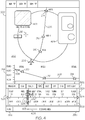
- FIG. 3 illustrates an HMI navigation display mechanism 300 in accordance with an exemplary embodiment.
- the mechanism includes a flight-phase indicator 302, a waypoint (WP) and estimated-time-of-arrival (ETA at that waypoint) or real time indicator 304, and a relative time scale 306.
- flight phase indicator includes a PREFLIGHT segment 310, a TAXI segment 312, a TAKEOFF segment 314, a CRS (cruise) segment 316 a DESC (descent) segment 318 APP (approach) segment 320, a TAXI segment 322, and a POSTFLIGHT segment 324, all together representing the entire flight.
- Segment 316 is visually distinguished to indicate that the flight is currently in the cruise segment.
- Waypoint and ETA indicator 304 shows that waypoints PABLB, KNIZE, SOSAL, HADLY, BODAL, BUKEV, TEMNO, ZLO, and BJAGA will be traversed by the flight, and the elapsed time will extend from before 11:22 until after 12:41.
- Relative time scale 306 display indicates the location of the flight in terms of elapsed time and remaining.
- HMI navigation display mechanism 300 also includes a time-forward button 326, a time-backward button 328, a feedback area 330, a return-to-home button 332, and a current-time indicator 334.
- Current time indicator 334 is slidable in both forward and backward directions (i.e. in both time and place) by means of dragging a handle 335 with a cursor in the case of a cursor-controlled device or dragging the handle 335 with a finger or stylus in the case of a touchscreen device.
- the entire time scale can be controlled via a knob on the cursor controlled device or a finger sliding the whole time scale.
- a notification icon 336 is also shown in FIG. 2 and is used to display a time-related notification. A user may activate the icon 336 by clicking, tapping, or the like, and more information relating to the notification will be displayed.
- FIG. 4 illustrates the navigation and vertical situation display shown and described in connection with FIG 2 having the HMI navigation display mechanism 300 incorporated therewith in accordance with a first exemplary embodiment.
- aircraft 206 is flying in the cruise segment (i.e. CRS 316 is highlighted) and following a path to WP SOSAL, continuing on to WP HADLY and then to WP BODAL.
- the crew detects (1) a temporarily restricted area 402 and (2) and a convection weather phenomena 404 that is active and to the left of flight plan 208.
- the flight crew may question what impact these have on the flight as it passes WP HADLY.
- a crewmember may slide time indicator 334 to the left (as indicated by arrow 406) in order to see the future situation. This is illustrated in FIG. 5 .
- the current aircraft position is depicted as a ghost aircraft 500 and begins moving along the flight path 208 until it reaches a location just prior to WP HADLY.
- the temporarily restricted area 402 in FIG. 4 will be inactive when aircraft reaches WP HADLY, but there will however be severe convection by the time WP HADLY is reached.
- the crew may decide to contact air traffic control and request rerouting in view of the weather.
- FIG. 6 is a flowchart of an interactive display process 600 for providing enhanced HMI navigation in accordance with an exemplary embodiment and capable of being carried out by the system shown and described in connection with FIG. 1 .
- airspace data e.g. traffic, weather, range, etc.
- a time/distance scale substantially coextensive with the region is also displayed (STEP 606).
- the time scale may a relative time scale, an absolute time scale, a scale delineated by flight phase, and a scale delineated by reference points such as waypoints.
- a slidable handle is provided on the displayed image to alter the region displayed (STEP 608). If a future time (region) is selected (STEP 612), the airspace data associated with the future region will be displayed. If a time (region) in the past is selected (STEP 614), the airspace data associated with the previous region will be displayed. If a current time (region) is selected (STEP 613), the airspace data associated with the current region will be displayed. When the appropriate region is displayed, the process ends (STEP 616). It is to be noted that the functions that are subject to the HMI navigation system may be continuous (i.e. temporal), sequential (i.e. flight phase, waypoints, etc.), or time-based (i.e. past, present, and future).
- a system and method for producing an HMI navigation mechanism that; is not limited to displaying forecast information but can also display time and position related data such as NOTAMs, predictions, and estimations; does not merely switch between present and future information and provides sequential and continuous navigation from past, through present to future; is reusable and consistent when manipulating timeline information, and (4) provides a moving-to-the-future capability that enables to see how things will look (e.g., remaining fuel estimate at a future point of interest); and provides a moving-to-the-past capability (e.g., previous weather trends as they relate to current and/or future position.
- time and position related data such as NOTAMs, predictions, and estimations
Landscapes
- Engineering & Computer Science (AREA)
- Physics & Mathematics (AREA)
- General Physics & Mathematics (AREA)
- Aviation & Aerospace Engineering (AREA)
- General Engineering & Computer Science (AREA)
- Theoretical Computer Science (AREA)
- Radar, Positioning & Navigation (AREA)
- Remote Sensing (AREA)
- Human Computer Interaction (AREA)
- Navigation (AREA)
- Traffic Control Systems (AREA)
- Automation & Control Theory (AREA)
Applications Claiming Priority (2)
| Application Number | Priority Date | Filing Date | Title |
|---|---|---|---|
| US14/299,197 US9335917B2 (en) | 2014-06-09 | 2014-06-09 | System and method for providing enhanced HMI navigation |
| EP15168543.5A EP2955484A1 (fr) | 2014-06-09 | 2015-05-20 | Système et procédé permettant d'obtenir une meilleure navigation dans l'ihm |
Related Parent Applications (1)
| Application Number | Title | Priority Date | Filing Date |
|---|---|---|---|
| EP15168543.5A Division EP2955484A1 (fr) | 2014-06-09 | 2015-05-20 | Système et procédé permettant d'obtenir une meilleure navigation dans l'ihm |
Publications (1)
| Publication Number | Publication Date |
|---|---|
| EP3693706A1 true EP3693706A1 (fr) | 2020-08-12 |
Family
ID=53275991
Family Applications (2)
| Application Number | Title | Priority Date | Filing Date |
|---|---|---|---|
| EP15168543.5A Ceased EP2955484A1 (fr) | 2014-06-09 | 2015-05-20 | Système et procédé permettant d'obtenir une meilleure navigation dans l'ihm |
| EP20158229.3A Ceased EP3693706A1 (fr) | 2014-06-09 | 2015-05-20 | Système et procédé permettant d'obtenir une meilleure navigation dans l'ihm |
Family Applications Before (1)
| Application Number | Title | Priority Date | Filing Date |
|---|---|---|---|
| EP15168543.5A Ceased EP2955484A1 (fr) | 2014-06-09 | 2015-05-20 | Système et procédé permettant d'obtenir une meilleure navigation dans l'ihm |
Country Status (3)
| Country | Link |
|---|---|
| US (1) | US9335917B2 (fr) |
| EP (2) | EP2955484A1 (fr) |
| CN (1) | CN105303893A (fr) |
Cited By (1)
| Publication number | Priority date | Publication date | Assignee | Title |
|---|---|---|---|---|
| WO2023287583A3 (fr) * | 2021-07-12 | 2023-03-09 | Termson Management Llc | Routage interactif |
Families Citing this family (28)
| Publication number | Priority date | Publication date | Assignee | Title |
|---|---|---|---|---|
| US10389396B1 (en) * | 2011-11-17 | 2019-08-20 | Michael L. Gibbons | Terrain awareness and warning aircraft indicator equipment |
| USD823312S1 (en) * | 2014-08-11 | 2018-07-17 | Sony Corporation | Display panel or screen with graphical user interface |
| US9672747B2 (en) * | 2015-06-15 | 2017-06-06 | WxOps, Inc. | Common operating environment for aircraft operations |
| US9581461B1 (en) | 2016-01-05 | 2017-02-28 | Allstate Insurance Company | Data processing system communicating with a map data processing system to generate a display of one or more segments of one or more vehicle routes |
| US10176721B2 (en) * | 2016-12-06 | 2019-01-08 | Honeywell International Inc. | System and method to depict geodetic reference datum non-compliance regions, airports, and flight planning elements on avionics based displays |
| JP6558393B2 (ja) | 2017-04-06 | 2019-08-14 | トヨタ自動車株式会社 | 進路設定装置及び進路設定方法 |
| US10311738B2 (en) | 2017-05-08 | 2019-06-04 | Honeywell International Inc. | Display system and method for indicating a time-based requirement |
| US10672279B2 (en) * | 2017-09-26 | 2020-06-02 | Honeywell International Inc. | Systems and methods for presenting an intuitive timeline visualization via an avionics primary flight display (PFD) |
| US10417916B2 (en) * | 2017-10-11 | 2019-09-17 | Honeywell International Inc. | Method and system to provide contextual auto-correlation of vertical situational display objects to objects displayed on a lateral map display based on a priority scheme |
| US10997865B2 (en) * | 2017-11-16 | 2021-05-04 | The Boeing Company | Airport congestion determination for effecting air navigation planning |
| DE102018202854B4 (de) * | 2018-02-26 | 2020-01-02 | Audi Ag | Verfahren zum Betrieb eines Bordnetzes eines Hybridkraftfahrzeugs und Hybridkraftfahrzeug |
| US11328610B2 (en) * | 2018-07-24 | 2022-05-10 | Honeywell International Inc. | Custom search queries for flight data |
| US11262900B1 (en) * | 2018-07-30 | 2022-03-01 | The Boeing Company | Graphical user interface in a computer system in an aircraft |
| DE102018120010A1 (de) * | 2018-08-16 | 2020-02-20 | Autel Robotics Europe Gmbh | Routenanzeigeverfahren, -vorrichtung und -system, bodenstation und computerlesbares speichermedium |
| US10847040B2 (en) * | 2018-08-21 | 2020-11-24 | The Boeing Company | Restricted airspace monitoring systems and methods |
| US10582354B1 (en) | 2018-10-05 | 2020-03-03 | Allstate Insurance Company | Systems and methods for automatic breakdown detection and roadside assistance |
| EP3660461B1 (fr) * | 2018-11-27 | 2022-04-06 | Honeywell International Inc. | Systèmes et procédés pour fournir une assistance à la déviation sur un affichage de gestion de vol intégré |
| US11417220B2 (en) * | 2018-11-27 | 2022-08-16 | Honeywell International Inc. | Systems and methods for providing an integrated flight management display with interactive time-based functionality |
| US12300043B1 (en) | 2019-07-12 | 2025-05-13 | Allstate Insurance Company | Roadside assistance detection |
| US10854092B1 (en) * | 2019-09-20 | 2020-12-01 | Honeywell International Inc. | Method and system to improve the situational awareness of all aerodrome ground operations including all turnaround airport collaborative decision making (A-CDM) milestones in the cockpit |
| US11447272B2 (en) * | 2020-07-08 | 2022-09-20 | Lockheed Martin Corporation | Interactive electronic checklists for autonomous aircraft |
| US20220147905A1 (en) * | 2020-11-12 | 2022-05-12 | Honeywell International Inc. | System and method for assisting flight crew with the execution of clearance messages |
| US11320980B1 (en) | 2021-02-25 | 2022-05-03 | Rockwell Collins, Inc. | Flight and task management timeline display with absolute and relative time scaling |
| US11787557B2 (en) * | 2021-04-30 | 2023-10-17 | Honeywell International Inc. | Methods and systems for representing a time scale on a cockpit display |
| US11912431B2 (en) * | 2021-09-20 | 2024-02-27 | Rockwell Collins, Inc. | Time based overlay for positional map displays |
| CN114202989B (zh) * | 2021-12-10 | 2023-11-03 | 安胜(天津)飞行模拟系统有限公司 | 用于不同电动垂直起降飞机的通用培训设备及方法 |
| US20250304255A1 (en) * | 2024-03-28 | 2025-10-02 | Thales Avionics, Inc. | System for displaying astronomical objects and events viewable by passengers along flight route |
| US20260015101A1 (en) * | 2024-07-12 | 2026-01-15 | Honeywell International Inc. | Systems, apparatuses, methods, and computer program products for initiating performance of one or more aviation related actions |
Citations (8)
| Publication number | Priority date | Publication date | Assignee | Title |
|---|---|---|---|---|
| US20100030401A1 (en) * | 2008-07-31 | 2010-02-04 | Honeywell International Inc. | Flight deck communication and display system |
| US20100315265A1 (en) * | 2008-08-20 | 2010-12-16 | Smith Robert P | Automated turbulence display system |
| US20110010082A1 (en) * | 2009-07-09 | 2011-01-13 | Honeywell International Inc. | Methods and systems for route-based scrolling of a navigational map |
| US20110118908A1 (en) * | 2009-11-18 | 2011-05-19 | The Boeing Company | Methods and systems for management of airplane speed profile |
| US20120232785A1 (en) * | 2011-03-11 | 2012-09-13 | Thorsten Wiesemann | Methods and systems for dynamically providing contextual weather information |
| EP2574965A2 (fr) * | 2011-09-30 | 2013-04-03 | The Boeing Company | Notification météorologique sélective |
| FR2984486A1 (fr) * | 2011-12-20 | 2013-06-21 | Thales Sa | Procede de representation temporelle des informations de navigation d'un aeronef sur un dispositif de visualisation |
| US20130268878A1 (en) * | 2010-12-17 | 2013-10-10 | Yannick Le Roux | Method for the temporal display of the mission of an aircraft |
Family Cites Families (7)
| Publication number | Priority date | Publication date | Assignee | Title |
|---|---|---|---|---|
| US7765061B1 (en) | 2006-05-18 | 2010-07-27 | Rockwell Collins, Inc. | Flight display system with enhanced temporal depiction of navigation information |
| FR2923008B1 (fr) | 2007-10-26 | 2010-01-08 | Thales Sa | Procede et dispositif d'affichage de previsions sur un plan de navigation |
| US20100153875A1 (en) | 2008-12-16 | 2010-06-17 | O'flynn Mark James | Air traffic control apparatus and air traffic control information processing method |
| US8471727B2 (en) | 2009-11-03 | 2013-06-25 | The Boeing Company | Method, apparatus and computer program product for displaying forecast weather products with actual and predicted ownship |
| US8682580B2 (en) | 2010-08-05 | 2014-03-25 | The Boeing Company | Data driven route strip |
| US9153137B2 (en) * | 2010-12-13 | 2015-10-06 | The Boeing Company | Temporally based weather symbology |
| FR2998959B1 (fr) | 2012-11-30 | 2015-11-20 | Thales Sa | Procede d'affichage d'un plan de vol aeronautique comprenant une etape de parametrage des donnees de vol |
-
2014
- 2014-06-09 US US14/299,197 patent/US9335917B2/en active Active
-
2015
- 2015-05-20 EP EP15168543.5A patent/EP2955484A1/fr not_active Ceased
- 2015-05-20 EP EP20158229.3A patent/EP3693706A1/fr not_active Ceased
- 2015-06-08 CN CN201510308541.5A patent/CN105303893A/zh active Pending
Patent Citations (8)
| Publication number | Priority date | Publication date | Assignee | Title |
|---|---|---|---|---|
| US20100030401A1 (en) * | 2008-07-31 | 2010-02-04 | Honeywell International Inc. | Flight deck communication and display system |
| US20100315265A1 (en) * | 2008-08-20 | 2010-12-16 | Smith Robert P | Automated turbulence display system |
| US20110010082A1 (en) * | 2009-07-09 | 2011-01-13 | Honeywell International Inc. | Methods and systems for route-based scrolling of a navigational map |
| US20110118908A1 (en) * | 2009-11-18 | 2011-05-19 | The Boeing Company | Methods and systems for management of airplane speed profile |
| US20130268878A1 (en) * | 2010-12-17 | 2013-10-10 | Yannick Le Roux | Method for the temporal display of the mission of an aircraft |
| US20120232785A1 (en) * | 2011-03-11 | 2012-09-13 | Thorsten Wiesemann | Methods and systems for dynamically providing contextual weather information |
| EP2574965A2 (fr) * | 2011-09-30 | 2013-04-03 | The Boeing Company | Notification météorologique sélective |
| FR2984486A1 (fr) * | 2011-12-20 | 2013-06-21 | Thales Sa | Procede de representation temporelle des informations de navigation d'un aeronef sur un dispositif de visualisation |
Cited By (1)
| Publication number | Priority date | Publication date | Assignee | Title |
|---|---|---|---|---|
| WO2023287583A3 (fr) * | 2021-07-12 | 2023-03-09 | Termson Management Llc | Routage interactif |
Also Published As
| Publication number | Publication date |
|---|---|
| US9335917B2 (en) | 2016-05-10 |
| US20150355832A1 (en) | 2015-12-10 |
| CN105303893A (zh) | 2016-02-03 |
| EP2955484A1 (fr) | 2015-12-16 |
Similar Documents
| Publication | Publication Date | Title |
|---|---|---|
| US9335917B2 (en) | System and method for providing enhanced HMI navigation | |
| EP3048424B1 (fr) | Procédés et systèmes pour affichage d'informations de prévisions météorologiques sur la base d'un itinéraire | |
| EP2922046B1 (fr) | Système et procédé permettant d'obtenir une meilleure gestion de plan de vol | |
| EP2679959B1 (fr) | Système d'affichage avionique assurant une meilleure gestion de plan de vol | |
| US9593961B2 (en) | System and method for integrated time based notification for improved situational awareness | |
| EP2273236B1 (fr) | Procédés et systèmes pour le défilement d'une carte de navigation basé sur l'itinéraire | |
| EP2623935B1 (fr) | Système et procédé d'affichage de plage et d'échelles de temps basé sur la performance sur un écran de navigation | |
| US9105183B2 (en) | System and method for graphically displaying aircraft traffic information using aircraft symbology | |
| US10854092B1 (en) | Method and system to improve the situational awareness of all aerodrome ground operations including all turnaround airport collaborative decision making (A-CDM) milestones in the cockpit | |
| US20120035849A1 (en) | Data Driven Route Strip | |
| EP2781884B1 (fr) | Système et procédé d'affichage graphique de données de vitesse dans l'espace aérien | |
| EP2282174A2 (fr) | Système de gestion de vols, procédé et produit de programme permettant la commutation dynamique d'un mode d'approche de non précision à l'autre | |
| EP2741053B1 (fr) | Procédé de génération graphique de cours d'approche | |
| US9168859B2 (en) | System and method for displaying visual flight reference points | |
| EP3657131B1 (fr) | Système et procédé de présentation de liste de point de cheminement | |
| US20160041001A1 (en) | System and method for enhancing altitude situational awareness on a vertical situation display | |
| EP4160572A1 (fr) | Systèmes et procédés d'alerte lorsqu'un vecteur de tendance d'intrusion est prédit pour s'intercepter avec un trajet de roulage au sol d'un aéronef | |
| US11787557B2 (en) | Methods and systems for representing a time scale on a cockpit display |
Legal Events
| Date | Code | Title | Description |
|---|---|---|---|
| PUAI | Public reference made under article 153(3) epc to a published international application that has entered the european phase |
Free format text: ORIGINAL CODE: 0009012 |
|
| STAA | Information on the status of an ep patent application or granted ep patent |
Free format text: STATUS: REQUEST FOR EXAMINATION WAS MADE |
|
| 17P | Request for examination filed |
Effective date: 20200219 |
|
| AC | Divisional application: reference to earlier application |
Ref document number: 2955484 Country of ref document: EP Kind code of ref document: P |
|
| AK | Designated contracting states |
Kind code of ref document: A1 Designated state(s): AL AT BE BG CH CY CZ DE DK EE ES FI FR GB GR HR HU IE IS IT LI LT LU LV MC MK MT NL NO PL PT RO RS SE SI SK SM TR |
|
| STAA | Information on the status of an ep patent application or granted ep patent |
Free format text: STATUS: EXAMINATION IS IN PROGRESS |
|
| 17Q | First examination report despatched |
Effective date: 20210304 |
|
| RAP3 | Party data changed (applicant data changed or rights of an application transferred) |
Owner name: HONEYWELL INTERNATIONAL INC. |
|
| STAA | Information on the status of an ep patent application or granted ep patent |
Free format text: STATUS: THE APPLICATION HAS BEEN REFUSED |
|
| 18R | Application refused |
Effective date: 20220528 |
|
| P01 | Opt-out of the competence of the unified patent court (upc) registered |
Effective date: 20230525 |