EP3748291A1 - Verfahren zur verarbeitung von peripherieinformationen - Google Patents
Verfahren zur verarbeitung von peripherieinformationen Download PDFInfo
- Publication number
- EP3748291A1 EP3748291A1 EP19746813.5A EP19746813A EP3748291A1 EP 3748291 A1 EP3748291 A1 EP 3748291A1 EP 19746813 A EP19746813 A EP 19746813A EP 3748291 A1 EP3748291 A1 EP 3748291A1
- Authority
- EP
- European Patent Office
- Prior art keywords
- information
- feature
- light transparent
- transparent region
- surrounding information
- Prior art date
- Legal status (The legal status is an assumption and is not a legal conclusion. Google has not performed a legal analysis and makes no representation as to the accuracy of the status listed.)
- Withdrawn
Links
- 230000010365 information processing Effects 0.000 title 1
- 230000002093 peripheral effect Effects 0.000 title 1
- 238000003672 processing method Methods 0.000 title 1
- 238000000034 method Methods 0.000 claims abstract description 22
- 230000005540 biological transmission Effects 0.000 claims description 7
- 238000005259 measurement Methods 0.000 description 15
- 230000004807 localization Effects 0.000 description 13
- 239000000463 material Substances 0.000 description 4
- 235000013305 food Nutrition 0.000 description 2
- 239000011521 glass Substances 0.000 description 2
- 230000003287 optical effect Effects 0.000 description 2
- 239000004925 Acrylic resin Substances 0.000 description 1
- 229920000178 Acrylic resin Polymers 0.000 description 1
- 238000001514 detection method Methods 0.000 description 1
- 238000010586 diagram Methods 0.000 description 1
- 239000005357 flat glass Substances 0.000 description 1
- 238000003384 imaging method Methods 0.000 description 1
- 238000002310 reflectometry Methods 0.000 description 1
- 239000011347 resin Substances 0.000 description 1
- 229920005989 resin Polymers 0.000 description 1
- 230000003068 static effect Effects 0.000 description 1
- 238000002834 transmittance Methods 0.000 description 1
Images

Classifications
-
- G—PHYSICS
- G01—MEASURING; TESTING
- G01S—RADIO DIRECTION-FINDING; RADIO NAVIGATION; DETERMINING DISTANCE OR VELOCITY BY USE OF RADIO WAVES; LOCATING OR PRESENCE-DETECTING BY USE OF THE REFLECTION OR RERADIATION OF RADIO WAVES; ANALOGOUS ARRANGEMENTS USING OTHER WAVES
- G01S7/00—Details of systems according to groups G01S13/00, G01S15/00, G01S17/00
- G01S7/003—Transmission of data between radar, sonar or lidar systems and remote stations
-
- G—PHYSICS
- G01—MEASURING; TESTING
- G01C—MEASURING DISTANCES, LEVELS OR BEARINGS; SURVEYING; NAVIGATION; GYROSCOPIC INSTRUMENTS; PHOTOGRAMMETRY OR VIDEOGRAMMETRY
- G01C21/00—Navigation; Navigational instruments not provided for in groups G01C1/00 - G01C19/00
- G01C21/38—Electronic maps specially adapted for navigation; Updating thereof
- G01C21/3804—Creation or updating of map data
-
- G—PHYSICS
- G01—MEASURING; TESTING
- G01S—RADIO DIRECTION-FINDING; RADIO NAVIGATION; DETERMINING DISTANCE OR VELOCITY BY USE OF RADIO WAVES; LOCATING OR PRESENCE-DETECTING BY USE OF THE REFLECTION OR RERADIATION OF RADIO WAVES; ANALOGOUS ARRANGEMENTS USING OTHER WAVES
- G01S17/00—Systems using the reflection or reradiation of electromagnetic waves other than radio waves, e.g. lidar systems
- G01S17/88—Lidar systems specially adapted for specific applications
- G01S17/89—Lidar systems specially adapted for specific applications for mapping or imaging
-
- G—PHYSICS
- G01—MEASURING; TESTING
- G01S—RADIO DIRECTION-FINDING; RADIO NAVIGATION; DETERMINING DISTANCE OR VELOCITY BY USE OF RADIO WAVES; LOCATING OR PRESENCE-DETECTING BY USE OF THE REFLECTION OR RERADIATION OF RADIO WAVES; ANALOGOUS ARRANGEMENTS USING OTHER WAVES
- G01S17/00—Systems using the reflection or reradiation of electromagnetic waves other than radio waves, e.g. lidar systems
- G01S17/88—Lidar systems specially adapted for specific applications
- G01S17/93—Lidar systems specially adapted for specific applications for anti-collision purposes
- G01S17/931—Lidar systems specially adapted for specific applications for anti-collision purposes of land vehicles
-
- G—PHYSICS
- G01—MEASURING; TESTING
- G01S—RADIO DIRECTION-FINDING; RADIO NAVIGATION; DETERMINING DISTANCE OR VELOCITY BY USE OF RADIO WAVES; LOCATING OR PRESENCE-DETECTING BY USE OF THE REFLECTION OR RERADIATION OF RADIO WAVES; ANALOGOUS ARRANGEMENTS USING OTHER WAVES
- G01S17/00—Systems using the reflection or reradiation of electromagnetic waves other than radio waves, e.g. lidar systems
- G01S17/02—Systems using the reflection of electromagnetic waves other than radio waves
- G01S17/06—Systems determining position data of a target
- G01S17/42—Simultaneous measurement of distance and other co-ordinates
-
- G—PHYSICS
- G01—MEASURING; TESTING
- G01S—RADIO DIRECTION-FINDING; RADIO NAVIGATION; DETERMINING DISTANCE OR VELOCITY BY USE OF RADIO WAVES; LOCATING OR PRESENCE-DETECTING BY USE OF THE REFLECTION OR RERADIATION OF RADIO WAVES; ANALOGOUS ARRANGEMENTS USING OTHER WAVES
- G01S17/00—Systems using the reflection or reradiation of electromagnetic waves other than radio waves, e.g. lidar systems
- G01S17/86—Combinations of lidar systems with systems other than lidar, radar or sonar, e.g. with direction finders
-
- G—PHYSICS
- G01—MEASURING; TESTING
- G01S—RADIO DIRECTION-FINDING; RADIO NAVIGATION; DETERMINING DISTANCE OR VELOCITY BY USE OF RADIO WAVES; LOCATING OR PRESENCE-DETECTING BY USE OF THE REFLECTION OR RERADIATION OF RADIO WAVES; ANALOGOUS ARRANGEMENTS USING OTHER WAVES
- G01S13/00—Systems using the reflection or reradiation of radio waves, e.g. radar systems; Analogous systems using reflection or reradiation of waves whose nature or wavelength is irrelevant or unspecified
- G01S13/88—Radar or analogous systems specially adapted for specific applications
- G01S13/93—Radar or analogous systems specially adapted for specific applications for anti-collision purposes
- G01S13/931—Radar or analogous systems specially adapted for specific applications for anti-collision purposes of land vehicles
- G01S2013/9316—Radar or analogous systems specially adapted for specific applications for anti-collision purposes of land vehicles combined with communication equipment with other vehicles or with base stations
-
- G—PHYSICS
- G01—MEASURING; TESTING
- G01S—RADIO DIRECTION-FINDING; RADIO NAVIGATION; DETERMINING DISTANCE OR VELOCITY BY USE OF RADIO WAVES; LOCATING OR PRESENCE-DETECTING BY USE OF THE REFLECTION OR RERADIATION OF RADIO WAVES; ANALOGOUS ARRANGEMENTS USING OTHER WAVES
- G01S13/00—Systems using the reflection or reradiation of radio waves, e.g. radar systems; Analogous systems using reflection or reradiation of waves whose nature or wavelength is irrelevant or unspecified
- G01S13/88—Radar or analogous systems specially adapted for specific applications
- G01S13/93—Radar or analogous systems specially adapted for specific applications for anti-collision purposes
- G01S13/931—Radar or analogous systems specially adapted for specific applications for anti-collision purposes of land vehicles
- G01S2013/9323—Alternative operation using light waves
Definitions
- the present invention relates to a method for processing surrounding information.
- a moving body e.g. a vehicle
- a sensor for recognizing an object which exists in surroundings of the moving body e.g. a moving body
- a moving body with a plurality of laser radars as sensors is proposed (see e.g. Patent Document 1).
- the moving body is configured so that a road feature can be recognized as a surrounding object by scanning with a laser light.
- Patent Document 1 JP 2011-196916 A
- Information about surroundings of the moving body (measurement vehicle) which is obtained with a method as disclosed in Patent Document 1 may be stored in a storage unit such as an external server and used for driver assistance.
- a storage unit such as an external server and used for driver assistance.
- each of moving bodies (travelling vehicles) may recognize an object in the surroundings by using a sensor individually and match it with information acquired from the storage unit in order to estimate a current position of the moving body.
- varying information about the object which is located in the surroundings of the moving body may be acquired depending on the environment at the time of measurement, even if the object is static. In this case, discrepancy may occur between the information stored previously and the newly acquired information, wherein an error may be generated in estimation of the current position.
- an example of objectives of the present invention may be to provide a method for processing surrounding information which enables improvement of accuracy for estimation of a current position of a moving body.
- a method for processing surrounding information according to the present invention as defined in claim 1 includes: a surrounding information acquisition step for acquiring surrounding information about an object with a sensor positioned at a moving body, the object existing in surroundings of the moving body; a feature data acquisition step for acquiring feature data including information about an attribute of a feature; and a generation step for generating information after removal by removing at least light transparent region information about a light transparent region from the surrounding information based on the attribute of the feature included in the feature data, the light transparent region being included in the feature.
- a method for processing surrounding information includes a surrounding information acquisition step for acquiring surrounding information about an object with a sensor positioned at a moving body, the object existing in surroundings of the moving body; a feature data acquisition step for acquiring feature data including information about an attribute of a feature; and a generation step for generating information after removal by removing at least light transparent region information about a light transparent region from the surrounding information based on the attribute of the feature included in the feature data, the light transparent region being included in the feature.
- a current position for each of moving bodies can be estimated with information after removal by removing at least the light transparent region information from the surrounding information and thereby generating this information after removal.
- the light transparent region has reflectivity and/or transmittance etc. which may vary depending on the environment, such as external brightness
- information to be acquired (information corresponding to the light transparent region itself, and information corresponding to an object located behind the light transparent region as seen from a sensor) may vary in case that the object is optically detected to acquire the information.
- the estimation accuracy can be improved by omitting the information about the light transparent region for which the acquired information may vary.
- the term "light transparent region” as used in the present embodiment generally means all light transparent elements which are provided along a travelling path of the moving body and e.g. at a building in the surroundings, wherein such light transparent elements may include e.g. a window glass for a building and a glass element which constitutes an entire wall of the building. It is further to be noted that material for the light transparent region is not limited to glass, but may be a resin, such as acrylic resin.
- the attribute of the feature indicates whether it is a residence or a store, wherein in case where the feature is a store, the attribute also indicates its business form.
- the business form of the store is e.g. a retail store for foods etc. (e.g. a supermarket, convenience store) or a store with a showroom (e.g. a clothing store, a car dealer)
- the building has a light transparent region with high likelihood.
- the attribute of the feature whether the feature includes a light transparent region or not, how much ratio of a wall surface of the building is occupied by the light transparent region, and so on.
- the feature is a residence, it may be determined that the building has a light transparent region on a south wall surface with high likelihood.
- the feature including a light transparent region determines a position of the light transparent region based on an associated attribute, it is only needed in the generation step to remove the light transparent region information, wherein if it is not possible to determine the position of the light transparent region, information about the whole feature (i.e. information including the light transparent region information) may be removed.
- the method for processing surrounding information further includes a transmission step for transmitting the information after removal to the outside.
- a transmission step for transmitting the information after removal to the outside.
- a method for processing surrounding information includes a surrounding information acquisition step for acquiring surrounding information about an object from a moving body with a sensor positioned thereon, the object existing in surroundings of the moving body, a generation step for generating information after removal by removing at least light transparent region information about a light transparent region from the surrounding information based on an attribute of a feature included in feature data, the light transparent region being included in the feature.
- current positions for moving bodies can be estimated with increased estimation accuracy by removing at least the light transparent region information from the surrounding information and thereby generating the information after removal, in a similar manner with the previous embodiment.
- a method according to the present invention may preferably include a map creation step for creating or updating map data based on the information after removal.
- a driver assistance system 1 is configured with a measurement vehicle 10 as a moving body, an external server 20 as a storage unit, a plurality of travelling vehicles 30 as moving bodies.
- the driver assistance system 1 is provided so that information is collected by the measurement vehicle 10 and the collected information is stored in the external server 20, wherein current positions are estimated in the travelling vehicles 30 by using the information in the external server 20.
- the measurement vehicle 10 is provided with an information acquisition device 11 for acquiring information about features as objects (path features located along a path for vehicles, and surrounding features located in the periphery of the road).
- the information acquisition device 11 includes a sensor 12, an input and output unit 13 and a controller 14.
- the measurement vehicle 10 is further provided with a current position acquisition unit 15 and configured to be capable of acquiring current positions.
- An example for the current position acquisition unit 15 may be a GPS receiver which receives radio waves transmitted from a plurality of GPS (Global Positioning System) satellites in a known manner.
- the sensor 12 includes a projection unit for projecting electromagnetic waves, and a receiving unit for receiving a reflected wave of the electromagnetic waves which is reflected by an irradiated object (object existing in the surroundings of the measurement vehicle 10).
- the sensor 12 may be any optical sensor which projects light and receives a reflected light which is reflected by the irradiated object (so-called LIDAR (Laser Imaging Detection and Ranging)).
- LIDAR Laser Imaging Detection and Ranging
- the sensor 12 performs scanning with electromagnetic waves and acquires point cloud information which is represented with three variables, i.e. a horizontal scanning angle ⁇ , a vertical scanning angle ⁇ , and a distance r where the object is detected.
- the information acquisition device 11 may include an auxiliary sensor such as a camera.
- the input and output unit 13 is formed from a circuit and/or antenna for communicating with a network such as the Internet and/or a public line, wherein the input and output unit 13 communicates with the external server 20 and transmits/receives information to/from it.
- the controller 14 is constituted from a CPU (Central Processing Unit) with a memory such as a RAM (Random Access Memory) and/or a ROM (Read Only Memory) and configured to manage the entire control of the information acquisition device 11, wherein the controller 14 processes information acquired by the sensor 12 and transmits the processed information to the outside via the input and output unit 13, as described below.
- a CPU Central Processing Unit
- a memory such as a RAM (Random Access Memory) and/or a ROM (Read Only Memory) and configured to manage the entire control of the information acquisition device 11, wherein the controller 14 processes information acquired by the sensor 12 and transmits the processed information to the outside via the input and output unit 13, as described below.
- the external server 20 includes a storage unit body 21, an input and output unit 22, and a controller 23.
- the external server 20 is capable of communicating with the information acquisition device 11 and the travelling vehicles 30 via a network such as the Internet, and acquires information from the information acquisition device 11 and/or travelling vehicles 30 via the network.
- a network such as the Internet
- the information acquisition of the external server 20 is not limited to the above configuration. For example, information may be moved manually by an operator etc. without a network from the information acquisition device 11 to the external server 20.
- information is transmitted/received via the network for providing/receiving the information between the information acquisition device 11 and the travelling vehicles 30 as well as the external server 20, all of these are not limited to this configuration as noted above, wherein information may be provided/received manually by an operator.
- the storage unit body 21 is constituted e.g. with a hard disk and/or a nonvolatile memory and configured to storage map data, wherein writing in and reading from the storage unit body 21 is performed under control of the controller 23.
- the map data includes feature data, wherein the feature data include attributes of individual features. For example, in case where the feature is a building, the attribute of the feature indicates whether it is a residence or a store. Particularly in case where the feature is a store, the attribute also indicates its business form. It is to be noted that due to a data structure for storage in the storage unit body 21, the storage unit body 21 may be configured to store the map data and the feature data separately.
- the input and output unit 22 is formed from a circuit and/or antenna for communicating with a network such as the Internet and/or a public line, wherein the input and output unit 22 communicates with the information acquisition device 11 and the travelling vehicles 30 and transmits/receives information to/from them.
- the controller 23 is constituted from a CPU with a memory such as a RAM and/or a ROM, and configured to manage the entire control of the external server 20.
- the travelling vehicles 30 are provided with localization units 31 for estimating current positions for the travelling vehicles 30.
- Each of the localization units 31 is used together with a current position acquisition unit (GPS receiver) 35 which is provided in a travelling vehicle 30 associated with the localization unit 31.
- GPS receiver current position acquisition unit
- Each of the localization units 31 includes a sensor 32, an input and output unit 33 and a controller 34.
- Each of the sensors 32 includes a projection unit for projecting electromagnetic waves, and a receiving unit for receiving a reflected wave of the electromagnetic waves which is reflected by an irradiated object (object existing in the surroundings of the travelling vehicle 30).
- An example for the sensor 32 may be an optical sensor which projects light and receives a reflected light which is reflected by the irradiated object.
- the input and output unit 33 is formed from a circuit and/or antenna for communicating with a network such as the Internet and/or a public line, wherein the input and output unit 33 communicates with the external server 20 and transmits/receives information to/from it.
- the input and output unit 33 may only receive information from the external server 20. It is to be noted that receiving the information from the external server 20 is not limited to the above configuration. For example, information may be moved manually by an operator etc. without a network from the external server 20 to the localization units 31.
- the controller 34 is constituted from a CPU with a memory such as a RAM and/or a ROM, and configured to manage the entire control of the localization unit 31.
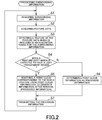
- step S1 surrounding information acquisition step
- the controller 14 acquires the feature data from the external server 20 via the input and output unit 13 (step S2, feature data acquisition step).
- the step S2 may be omitted by acquiring the feature data from the external server 20 and storing it in the information acquisition device 11 in advance.
- the controller 14 detects a feature of the acquired feature data which is included in an acquisition range for the surrounding information (step S3), and determines based on an attribute of the feature whether a feature which is expected to have a light transparent region exists or not (step S4).
- a retail store for foods etc. e.g. a supermarket, convenience store
- a store with a showroom e.g. a clothing store, a car dealer
- a plurality of features which are expected to have light transparent regions may be determined in step S4.
- step S4 If a feature which is to expected to have a light transparent region exists (Y in step S4), the controller 14 removes a point cloud corresponding to this whole feature from the point cloud information acquired by the sensor 12 in order to generate information after removal (step S5). This means that a point cloud at a position where the feature exists is eliminated.
- the processed information is determined as the information after removal.
- the steps S3 to S5 as described above form a generation step.
- step S4 determines the point cloud information acquired by the sensor 12 as the processed information (step S6). After steps S5 and S6, the controller 14 transmits the processed information to the external server 20 via the input and output unit 13 (step S7, transmission step). In step S7, the controller 14 further transmits the current position information for the measurement vehicle 10 together. After step S7, the process returns back to step S1 and the controller 14 repeats the above steps.
- the external server 20 receives the processed information transmitted according to the transmission step as described above (step S7) via the input and output unit 22.
- the controller 23 creates the map data based on this processed information (map creation step). It is to be noted that in case that the map data has been already stored in the storage unit body 21, this map data may be updated when receiving the processed information.
- the localization unit 31 acquires the map data from the external server 20 via the input and output unit 33 at predetermined timing.
- the localization unit 31 further acquires coarse information about a current position of a travelling vehicle 30 associated with the localization unit 31 from the current position acquisition unit 35.
- the localization unit 31 receives a reflected light via the sensor 32, the reflected light being reflected by a feature, wherein the localization unit 31 estimates a detailed current position for the travelling vehicle 30 by matching a distance from the feature with feature information included in the map data which is acquired from the external server 20.
- step S3 to S5 Even if the sensor 32 receives a reflected light reflected by a surface of the light transparent region and/or a reflected light reflected by an object behind the light transparent region, the information will not be used for the current position estimation, since at this time the point cloud corresponding to the whole feature including the light transparent region has been removed from the point cloud information in the above generation step (step S3 to S5). On the other hand, since a point cloud for a feature which does not have a light transparent region is not removed, information about this feature will used for current position estimation when the sensor 32 receives a reflected light reflected by the feature.
- the estimation accuracy can be improved by omitting the information about the light transparent region for which the acquired information may vary.
- the present invention is not limited to the exemplar embodiments as described above, but includes further configurations etc. which can achieve the objective of the present invention, wherein the present invention includes variations as shown below as well.
- the controller 14 in the measurement vehicle 10 performs processing the surrounding information which includes the surrounding information acquisition step, the feature data acquisition step, the generation step and the transmission step.
- the controller 23 in the external server 20 may perform processing the surrounding information which includes the surrounding information acquisition step, the feature data acquisition step and the generation step.
- the controller 14 in the information acquisition device 11 may transmit the surrounding information acquired by the sensor 12 to the external server 20 without processing the surrounding information. Then, the controller 23 in the external server 20 acquires this surrounding information via the input and output unit 22 (surrounding information acquisition step), acquires the feature data from the storage unit body 21 (feature data acquisition step), and generates the information after removal by removing the light transparent region information from the surrounding information (generation step). It is to be noted that it is sufficient if the generation step is similar with that according to the previous exemplar embodiment.
- the improved estimation accuracy can be achieved by omitting the information about the light transparent region in estimation of the current position, wherein the acquired information about the light transparent region may vary.
- the controller 14 in the information acquisition device 11 may perform the map creation step. This means that the information acquisition device 11 may create or update the map data and transmit this map data to the external server 20.
- the transmission step is included in processing the surrounding information carried out by the controller 14, the processing may not include the transmission step.
- the information acquisition device 11 may include a storage unit for storing the processed information, wherein data may be moved from the storage unit to the external server 20 after the measurement vehicle 10 has travelled through a predetermined area.
- the information about the feature including the light transparent region information is removed in the generation step.
- the feature including the light transparent region may be determined a position of the light transparent region based on an associated attribute.
- the "light transparent region information” refers to information indicative of the position of the light transparent region within the feature (in the previous exemplar embodiment, a point cloud at this position). This enables utilization of regions other than the light transparent regions of the feature for current position estimation of the travelling vehicles 30.
- the sensor 12 acquires the cloud information as the surrounding information, from which a point cloud corresponding the feature including the light transparent region is removed to generate the information after removal.
- the information acquisition method by the sensor is not limited thereto.
- the sensor may acquire image information as the surrounding information.
- the present invention is not limited thereto. Namely, while the present invention is particularly shown and described mainly with regard to the specific exemplar embodiments, the above mentioned exemplar embodiments may be modified in various manners in shape, material characteristics, amount or other detailed features without departing from the scope of the technical idea and purpose of the present invention. Therefore, the description with limited shapes, material characteristics etc. according to the above disclosure is not limiting the present invention, but merely illustrative for easier understanding the present invention so that the description using names of the elements without a part or all of the limitations to their shapes, material characteristics etc. is also included in the present invention.
Landscapes
- Engineering & Computer Science (AREA)
- Physics & Mathematics (AREA)
- Radar, Positioning & Navigation (AREA)
- Remote Sensing (AREA)
- General Physics & Mathematics (AREA)
- Computer Networks & Wireless Communication (AREA)
- Electromagnetism (AREA)
- Automation & Control Theory (AREA)
- Traffic Control Systems (AREA)
- Navigation (AREA)
- Instructional Devices (AREA)
- Optical Radar Systems And Details Thereof (AREA)
Applications Claiming Priority (2)
| Application Number | Priority Date | Filing Date | Title |
|---|---|---|---|
| JP2018015315 | 2018-01-31 | ||
| PCT/JP2019/002285 WO2019151106A1 (ja) | 2018-01-31 | 2019-01-24 | 周辺情報処理方法 |
Publications (2)
| Publication Number | Publication Date |
|---|---|
| EP3748291A1 true EP3748291A1 (de) | 2020-12-09 |
| EP3748291A4 EP3748291A4 (de) | 2021-10-27 |
Family
ID=67478171
Family Applications (1)
| Application Number | Title | Priority Date | Filing Date |
|---|---|---|---|
| EP19746813.5A Withdrawn EP3748291A4 (de) | 2018-01-31 | 2019-01-24 | Verfahren zur verarbeitung von peripherieinformationen |
Country Status (4)
| Country | Link |
|---|---|
| US (1) | US20210072392A1 (de) |
| EP (1) | EP3748291A4 (de) |
| JP (2) | JP6947853B2 (de) |
| WO (1) | WO2019151106A1 (de) |
Cited By (2)
| Publication number | Priority date | Publication date | Assignee | Title |
|---|---|---|---|---|
| WO2023129269A1 (en) * | 2022-01-03 | 2023-07-06 | Qualcomm Incorporated | Systems and methods for radio frequency (rf) ranging-aided localization and map generation |
| US12332362B2 (en) | 2022-01-03 | 2025-06-17 | Qualcomm Incorporated | Systems and methods for radio frequency (RF) ranging-aided localization and map generation |
Family Cites Families (9)
| Publication number | Priority date | Publication date | Assignee | Title |
|---|---|---|---|---|
| US8126642B2 (en) * | 2008-10-24 | 2012-02-28 | Gray & Company, Inc. | Control and systems for autonomously driven vehicles |
| US20110160919A1 (en) * | 2009-12-30 | 2011-06-30 | Orr David C | Mobile fluid delivery control system and method |
| JP2011196916A (ja) | 2010-03-23 | 2011-10-06 | Mitsubishi Electric Corp | 計測車両、道路地物計測システム |
| WO2012141235A1 (ja) * | 2011-04-13 | 2012-10-18 | 株式会社トプコン | 三次元点群位置データ処理装置、三次元点群位置データ処理システム、三次元点群位置データ処理方法およびプログラム |
| JP6354120B2 (ja) * | 2013-05-21 | 2018-07-11 | 株式会社デンソー | 道路情報送信装置、地図生成装置、道路情報収集システム |
| US9841763B1 (en) * | 2015-12-16 | 2017-12-12 | Uber Technologies, Inc. | Predictive sensor array configuration system for an autonomous vehicle |
| KR102373926B1 (ko) * | 2016-02-05 | 2022-03-14 | 삼성전자주식회사 | 이동체 및 이동체의 위치 인식 방법 |
| JP6685836B2 (ja) * | 2016-05-30 | 2020-04-22 | 株式会社東芝 | 情報処理装置、および、情報処理方法 |
| EP3467435A4 (de) * | 2016-06-01 | 2020-04-08 | Pioneer Corporation | Merkmalsdatenstruktur, speichermedium, informationsverarbeitungsvorrichtung und detektionsvorrichtung |
-
2019
- 2019-01-24 EP EP19746813.5A patent/EP3748291A4/de not_active Withdrawn
- 2019-01-24 JP JP2019569062A patent/JP6947853B2/ja not_active Expired - Fee Related
- 2019-01-24 US US16/965,288 patent/US20210072392A1/en not_active Abandoned
- 2019-01-24 WO PCT/JP2019/002285 patent/WO2019151106A1/ja not_active Ceased
-
2021
- 2021-09-15 JP JP2021149941A patent/JP2022003334A/ja active Pending
Cited By (2)
| Publication number | Priority date | Publication date | Assignee | Title |
|---|---|---|---|---|
| WO2023129269A1 (en) * | 2022-01-03 | 2023-07-06 | Qualcomm Incorporated | Systems and methods for radio frequency (rf) ranging-aided localization and map generation |
| US12332362B2 (en) | 2022-01-03 | 2025-06-17 | Qualcomm Incorporated | Systems and methods for radio frequency (RF) ranging-aided localization and map generation |
Also Published As
| Publication number | Publication date |
|---|---|
| WO2019151106A1 (ja) | 2019-08-08 |
| US20210072392A1 (en) | 2021-03-11 |
| EP3748291A4 (de) | 2021-10-27 |
| JP6947853B2 (ja) | 2021-10-13 |
| JPWO2019151106A1 (ja) | 2021-01-07 |
| JP2022003334A (ja) | 2022-01-11 |
Similar Documents
| Publication | Publication Date | Title |
|---|---|---|
| EP3631494B1 (de) | Kalibrierung integrierter sensoren in natürlichen szenen | |
| US10996072B2 (en) | Systems and methods for updating a high-definition map | |
| US10591594B2 (en) | Information processing apparatus, information processing method, and program | |
| EP3147884B1 (de) | Vorrichtung und verfahren zur erkennung einer verkehrsampel | |
| CN104035071B (zh) | 融合雷达/摄像机物体数据和LiDAR扫描点的方法和装置 | |
| JP4600357B2 (ja) | 測位装置 | |
| EP3358368A1 (de) | Signalverarbeitungsvorrichtung, signalverarbeitungsverfahren und programm | |
| JP6950832B2 (ja) | 位置座標推定装置、位置座標推定方法およびプログラム | |
| US10410072B2 (en) | Driving support apparatus, driving support system, driving support method, and computer readable recording medium | |
| JP2025065215A (ja) | 地図作成装置、制御方法、プログラム及び記憶媒体 | |
| JP2018189463A (ja) | 車両位置推定装置及びプログラム | |
| WO2020113425A1 (en) | Systems and methods for constructing high-definition map | |
| US20210072392A1 (en) | Method for processing surrounding information | |
| Pöppl et al. | Precise and efficient high-frequency trajectory estimation for LiDAR georeferencing | |
| JP2023068009A (ja) | 地図情報作成方法 | |
| WO2021056185A1 (en) | Systems and methods for partially updating high-definition map based on sensor data matching | |
| EP3748606A1 (de) | Verfahren zur erfassung von strassenoberflächeninformationen | |
| US11138448B2 (en) | Identifying a curb based on 3-D sensor data | |
| EP3748290A1 (de) | Verfahren zur verarbeitung von peripherieinformationen | |
| WO2019151105A1 (ja) | 周辺情報処理方法 | |
| JP2021179443A (ja) | 測定装置、測定方法およびプログラム | |
| WO2019151107A1 (ja) | 周辺情報処理方法 | |
| JPWO2018212280A1 (ja) | 測定装置、測定方法およびプログラム | |
| EP3742329A1 (de) | Dreidimensionale fahrstreifenverfolgung mit digitalem geländemodell | |
| WO2019151108A1 (ja) | 周辺情報処理方法 |
Legal Events
| Date | Code | Title | Description |
|---|---|---|---|
| STAA | Information on the status of an ep patent application or granted ep patent |
Free format text: STATUS: THE INTERNATIONAL PUBLICATION HAS BEEN MADE |
|
| PUAI | Public reference made under article 153(3) epc to a published international application that has entered the european phase |
Free format text: ORIGINAL CODE: 0009012 |
|
| STAA | Information on the status of an ep patent application or granted ep patent |
Free format text: STATUS: REQUEST FOR EXAMINATION WAS MADE |
|
| 17P | Request for examination filed |
Effective date: 20200731 |
|
| AK | Designated contracting states |
Kind code of ref document: A1 Designated state(s): AL AT BE BG CH CY CZ DE DK EE ES FI FR GB GR HR HU IE IS IT LI LT LU LV MC MK MT NL NO PL PT RO RS SE SI SK SM TR |
|
| AX | Request for extension of the european patent |
Extension state: BA ME |
|
| DAV | Request for validation of the european patent (deleted) | ||
| DAX | Request for extension of the european patent (deleted) | ||
| A4 | Supplementary search report drawn up and despatched |
Effective date: 20210928 |
|
| RIC1 | Information provided on ipc code assigned before grant |
Ipc: G01S 13/931 20200101ALN20210922BHEP Ipc: G01S 17/42 20060101ALN20210922BHEP Ipc: G01S 17/931 20200101ALI20210922BHEP Ipc: G01S 17/89 20200101ALI20210922BHEP Ipc: G01S 17/86 20200101ALI20210922BHEP Ipc: G01S 7/00 20060101ALI20210922BHEP Ipc: G01C 7/04 20060101ALI20210922BHEP Ipc: G01C 15/00 20060101AFI20210922BHEP |
|
| STAA | Information on the status of an ep patent application or granted ep patent |
Free format text: STATUS: THE APPLICATION HAS BEEN WITHDRAWN |
|
| 18W | Application withdrawn |
Effective date: 20231229 |