EP3842764A2 - Verfahren zur verarbeitung von navigationsdaten, pfadführungsverfahren, vorrichtung und speichermedium - Google Patents
Verfahren zur verarbeitung von navigationsdaten, pfadführungsverfahren, vorrichtung und speichermedium Download PDFInfo
- Publication number
- EP3842764A2 EP3842764A2 EP21164555.1A EP21164555A EP3842764A2 EP 3842764 A2 EP3842764 A2 EP 3842764A2 EP 21164555 A EP21164555 A EP 21164555A EP 3842764 A2 EP3842764 A2 EP 3842764A2
- Authority
- EP
- European Patent Office
- Prior art keywords
- lane
- road
- group
- link
- line
- Prior art date
- Legal status (The legal status is an assumption and is not a legal conclusion. Google has not performed a legal analysis and makes no representation as to the accuracy of the status listed.)
- Granted
Links
Images




Classifications
-
- G—PHYSICS
- G01—MEASURING; TESTING
- G01C—MEASURING DISTANCES, LEVELS OR BEARINGS; SURVEYING; NAVIGATION; GYROSCOPIC INSTRUMENTS; PHOTOGRAMMETRY OR VIDEOGRAMMETRY
- G01C21/00—Navigation; Navigational instruments not provided for in groups G01C1/00 - G01C19/00
- G01C21/26—Navigation; Navigational instruments not provided for in groups G01C1/00 - G01C19/00 specially adapted for navigation in a road network
- G01C21/34—Route searching; Route guidance
- G01C21/36—Input/output arrangements for on-board computers
- G01C21/3602—Input other than that of destination using image analysis, e.g. detection of road signs, lanes, buildings, real preceding vehicles using a camera
-
- G—PHYSICS
- G06—COMPUTING OR CALCULATING; COUNTING
- G06V—IMAGE OR VIDEO RECOGNITION OR UNDERSTANDING
- G06V20/00—Scenes; Scene-specific elements
- G06V20/50—Context or environment of the image
- G06V20/56—Context or environment of the image exterior to a vehicle by using sensors mounted on the vehicle
- G06V20/588—Recognition of the road, e.g. of lane markings; Recognition of the vehicle driving pattern in relation to the road
-
- B—PERFORMING OPERATIONS; TRANSPORTING
- B60—VEHICLES IN GENERAL
- B60W—CONJOINT CONTROL OF VEHICLE SUB-UNITS OF DIFFERENT TYPE OR DIFFERENT FUNCTION; CONTROL SYSTEMS SPECIALLY ADAPTED FOR HYBRID VEHICLES; ROAD VEHICLE DRIVE CONTROL SYSTEMS FOR PURPOSES NOT RELATED TO THE CONTROL OF A PARTICULAR SUB-UNIT
- B60W30/00—Purposes of road vehicle drive control systems not related to the control of a particular sub-unit, e.g. of systems using conjoint control of vehicle sub-units
- B60W30/10—Path keeping
- B60W30/12—Lane keeping
-
- B—PERFORMING OPERATIONS; TRANSPORTING
- B60—VEHICLES IN GENERAL
- B60W—CONJOINT CONTROL OF VEHICLE SUB-UNITS OF DIFFERENT TYPE OR DIFFERENT FUNCTION; CONTROL SYSTEMS SPECIALLY ADAPTED FOR HYBRID VEHICLES; ROAD VEHICLE DRIVE CONTROL SYSTEMS FOR PURPOSES NOT RELATED TO THE CONTROL OF A PARTICULAR SUB-UNIT
- B60W30/00—Purposes of road vehicle drive control systems not related to the control of a particular sub-unit, e.g. of systems using conjoint control of vehicle sub-units
- B60W30/18—Propelling the vehicle
- B60W30/18009—Propelling the vehicle related to particular drive situations
- B60W30/18163—Lane change; Overtaking manoeuvres
-
- G—PHYSICS
- G01—MEASURING; TESTING
- G01C—MEASURING DISTANCES, LEVELS OR BEARINGS; SURVEYING; NAVIGATION; GYROSCOPIC INSTRUMENTS; PHOTOGRAMMETRY OR VIDEOGRAMMETRY
- G01C21/00—Navigation; Navigational instruments not provided for in groups G01C1/00 - G01C19/00
- G01C21/26—Navigation; Navigational instruments not provided for in groups G01C1/00 - G01C19/00 specially adapted for navigation in a road network
- G01C21/34—Route searching; Route guidance
- G01C21/3407—Route searching; Route guidance specially adapted for specific applications
- G01C21/3415—Dynamic re-routing, e.g. recalculating the route when the user deviates from calculated route or after detecting real-time traffic data or accidents
-
- G—PHYSICS
- G01—MEASURING; TESTING
- G01C—MEASURING DISTANCES, LEVELS OR BEARINGS; SURVEYING; NAVIGATION; GYROSCOPIC INSTRUMENTS; PHOTOGRAMMETRY OR VIDEOGRAMMETRY
- G01C21/00—Navigation; Navigational instruments not provided for in groups G01C1/00 - G01C19/00
- G01C21/26—Navigation; Navigational instruments not provided for in groups G01C1/00 - G01C19/00 specially adapted for navigation in a road network
- G01C21/34—Route searching; Route guidance
- G01C21/36—Input/output arrangements for on-board computers
- G01C21/3605—Destination input or retrieval
- G01C21/3614—Destination input or retrieval through interaction with a road map, e.g. selecting a POI icon on a road map
-
- G—PHYSICS
- G01—MEASURING; TESTING
- G01C—MEASURING DISTANCES, LEVELS OR BEARINGS; SURVEYING; NAVIGATION; GYROSCOPIC INSTRUMENTS; PHOTOGRAMMETRY OR VIDEOGRAMMETRY
- G01C21/00—Navigation; Navigational instruments not provided for in groups G01C1/00 - G01C19/00
- G01C21/26—Navigation; Navigational instruments not provided for in groups G01C1/00 - G01C19/00 specially adapted for navigation in a road network
- G01C21/34—Route searching; Route guidance
- G01C21/36—Input/output arrangements for on-board computers
- G01C21/3605—Destination input or retrieval
- G01C21/3617—Destination input or retrieval using user history, behaviour, conditions or preferences, e.g. predicted or inferred from previous use or current movement
-
- G—PHYSICS
- G01—MEASURING; TESTING
- G01C—MEASURING DISTANCES, LEVELS OR BEARINGS; SURVEYING; NAVIGATION; GYROSCOPIC INSTRUMENTS; PHOTOGRAMMETRY OR VIDEOGRAMMETRY
- G01C21/00—Navigation; Navigational instruments not provided for in groups G01C1/00 - G01C19/00
- G01C21/26—Navigation; Navigational instruments not provided for in groups G01C1/00 - G01C19/00 specially adapted for navigation in a road network
- G01C21/34—Route searching; Route guidance
- G01C21/36—Input/output arrangements for on-board computers
- G01C21/3626—Details of the output of route guidance instructions
- G01C21/3629—Guidance using speech or audio output, e.g. text-to-speech
-
- G—PHYSICS
- G01—MEASURING; TESTING
- G01C—MEASURING DISTANCES, LEVELS OR BEARINGS; SURVEYING; NAVIGATION; GYROSCOPIC INSTRUMENTS; PHOTOGRAMMETRY OR VIDEOGRAMMETRY
- G01C21/00—Navigation; Navigational instruments not provided for in groups G01C1/00 - G01C19/00
- G01C21/26—Navigation; Navigational instruments not provided for in groups G01C1/00 - G01C19/00 specially adapted for navigation in a road network
- G01C21/34—Route searching; Route guidance
- G01C21/36—Input/output arrangements for on-board computers
- G01C21/3626—Details of the output of route guidance instructions
- G01C21/3644—Landmark guidance, e.g. using POIs or conspicuous other objects
-
- G—PHYSICS
- G01—MEASURING; TESTING
- G01C—MEASURING DISTANCES, LEVELS OR BEARINGS; SURVEYING; NAVIGATION; GYROSCOPIC INSTRUMENTS; PHOTOGRAMMETRY OR VIDEOGRAMMETRY
- G01C21/00—Navigation; Navigational instruments not provided for in groups G01C1/00 - G01C19/00
- G01C21/26—Navigation; Navigational instruments not provided for in groups G01C1/00 - G01C19/00 specially adapted for navigation in a road network
- G01C21/34—Route searching; Route guidance
- G01C21/36—Input/output arrangements for on-board computers
- G01C21/3626—Details of the output of route guidance instructions
- G01C21/3658—Lane guidance
-
- G—PHYSICS
- G01—MEASURING; TESTING
- G01C—MEASURING DISTANCES, LEVELS OR BEARINGS; SURVEYING; NAVIGATION; GYROSCOPIC INSTRUMENTS; PHOTOGRAMMETRY OR VIDEOGRAMMETRY
- G01C21/00—Navigation; Navigational instruments not provided for in groups G01C1/00 - G01C19/00
- G01C21/38—Electronic maps specially adapted for navigation; Updating thereof
- G01C21/3804—Creation or updating of map data
- G01C21/3807—Creation or updating of map data characterised by the type of data
- G01C21/3815—Road data
-
- B—PERFORMING OPERATIONS; TRANSPORTING
- B60—VEHICLES IN GENERAL
- B60W—CONJOINT CONTROL OF VEHICLE SUB-UNITS OF DIFFERENT TYPE OR DIFFERENT FUNCTION; CONTROL SYSTEMS SPECIALLY ADAPTED FOR HYBRID VEHICLES; ROAD VEHICLE DRIVE CONTROL SYSTEMS FOR PURPOSES NOT RELATED TO THE CONTROL OF A PARTICULAR SUB-UNIT
- B60W2552/00—Input parameters relating to infrastructure
- B60W2552/10—Number of lanes
-
- B—PERFORMING OPERATIONS; TRANSPORTING
- B60—VEHICLES IN GENERAL
- B60W—CONJOINT CONTROL OF VEHICLE SUB-UNITS OF DIFFERENT TYPE OR DIFFERENT FUNCTION; CONTROL SYSTEMS SPECIALLY ADAPTED FOR HYBRID VEHICLES; ROAD VEHICLE DRIVE CONTROL SYSTEMS FOR PURPOSES NOT RELATED TO THE CONTROL OF A PARTICULAR SUB-UNIT
- B60W2552/00—Input parameters relating to infrastructure
- B60W2552/53—Road markings, e.g. lane marker or crosswalk
Definitions
- the present application relates to a field of autonomous driving technology, in particular, to a field of advanced assisted driving technology and a field of road navigation technology, and more specifically, to a method and a device for processing navigation data, a path guidance method and device, an apparatus, and a storage medium.
- a navigation product such as a mobile Application (APP) may provide a road navigation service to a user.
- Providing such a road navigation service may generally include: finding an optimal path via a path planning algorithm based on city road network data, according to a travelling demand of a user, such as a place of departure or a destination; providing a user with map-based navigation guidance information and/or voice navigation prompt information after a path planning is completed.
- a user may travel from a place of departure to a destination by referring to the navigation information.
- a navigation product may provide a user with more and more information under the premise of completing a basic function of path planning. For example, if it is required to turn at an intersection ahead, a navigation product may prompt a user to enter a turning lane in advance, prompt for a congestion section, an accident-prone section, a speed limit, etc.
- traffic lanes also referred to as lane lines, on a road surface
- traffic lanes may guide vehicles to travel in an ordered-diversion manner.
- the amount and type of traffic lanes on a road surface are gradually increased, and there are more and more restrictions on traffic participants. Thus, it is required to optimize a navigation product.
- a method and device for processing navigation data, a path guidance method and device, an apparatus, and a storage medium are provided according to embodiments of the present application.
- a method for processing navigation data includes:
- a path guidance method is provided, which is based on data acquired by using the method for processing navigation data as described above.
- the path guidance method includes:
- a device for processing navigation data includes:
- a path guidance device which is based on data acquired by using the method for processing navigation data as described above.
- the path guidance device includes:
- an electronic apparatus includes:
- a non-transitory computer readable storage medium for storing computer instructions.
- the computer instructions when executed by a computer, cause the computer to perform the method described above.
- a road is divided into multiple lane groups, attribute information of lane lines on a road surface and the like are recorded in a grouping manner. Recorded data may be used to assist a basic navigation system to provide a more accurate navigation prompt, for example, in a road section with special lane lines or with complicated conditions, thereby improving the accuracy of a basic navigation system.
- FIG. 1 shows a flowchart of a method for processing navigation data provided according to an embodiment of the present application.
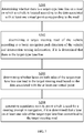
- the method includes:
- a road is divided into lane groups, for example, a road may be divided into multiple lane groups, detailed attribute information of lane lines on a road surface and the like are recorded in a grouping manner. Recorded data may be used to assist a basic navigation system to provide a more accurate and precise navigation prompt, for example, in a road section with special lane lines or with complicated conditions, thereby improving the preciseness and accuracy of a basic navigation system.
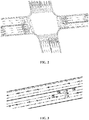
- relevant data may be acquired based on high-precision mapping technology. For example, by extracting a certain number of trajectory images obtained by a high-precision acquisition, high-precision Charge Coupled Device (CCD) camera images, and/or point cloud images, and then performing necessary processing on these images, such as trajectory calculating, coordinate matching, information fusion and/or top view mosaic, etc., a high-precision top view of roads as shown in FIG. 2 may be obtained.
- CCD Charge Coupled Device
- FIG. 3 shows an effect diagram of a road surface of a road with two-way traffic of the roads in the embodiment of FIG. 2 . Traffic orientations are denoted by arrows. The number of lanes with a traffic orientation towards left and the number of lanes with a traffic orientation towards right are 3, respectively.
- a lane line may be identified and attribute information of the lane line may be obtained, where the attribute information indicates, for example, the number of lane lines on a road, and the like.
- attribute information of a lane line may include at least one of: an amount of the lane line, a position of the lane line, a width of the lane line, a length of the lane line, a color of the lane line (e.g., white, yellow, and the like), a category of the lane line (e.g., line separation lines with same travelling directions or with opposite travelling directions, a dedicated lane sideline, a stop line, and the like), a line-type of a lane line (e.g., a broken line, a solid line), a traffic orientation of a lane line, an application type of a lane line (e.g., an ordinary lane, a bus lane, an emergency lane, and the like), restriction information related to a lane line (e.g., travelling time, speed limit, and the like), and a vehicle-travelling arrow of a lane line.
- attribute information of lane lines may include at least one of: an amount of the lane line,
- lane relationship information between an i th lane group and an (i + 1) th lane group includes: a continuation relation, a lane change relation and/or a crossing relation between respective lanes in the i th lane group and in the (i + 1) th lane group.
- a certain lane line it is a broken line in a first lane group, and it turns into a solid lane line when extending to a second lane group. That is, for lanes on both sides of the lane line in the first lane group, an occurrence of a lane change is allowed.
- Information associated with a conversion from "allowing an occurrence of a lane change" to "disallowing an occurrence of a lane change” belongs to lane relationship information between two lane groups.
- Attribute information of a lane line on a target road may be acquired via at least one of above methods, to provide a basis for a next group division step. After a road is divided into multiple lane groups, lane relationship information between lane groups may be obtained.
- a road is divided into multiple lane groups based on a grouping node and a dividing direction, where the grouping node is at a position where an attribute of a lane line changes and the dividing direction is perpendicular to a road axis.
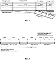
- FIG.4 shows a schematic diagram of an effect of dividing into lane groups according to an embodiment of the present application.
- the section of a road with a bifurcation is divided into six lane groups.
- Table 1 illustrates a way of group division of multiple lanes and related changes of attributes. Taking a position of group division being between a lane group A and a lane group B as an example. Because on the road surface, the number of lanes changes, that is, the road with three lanes changes to the road with four lanes, and there is a long solid line on the road surface, the lane group A and the lane group B may be obtained by taking the position the position where such change occurs as the position of the grouping node and dividing the road in the direction perpendicular to the solid line, where attributes of respective lane lines in the lane group A and in the lane group B themselves do not change.
- the lane group A connects forwards to the lane group B, and the lane group B bifurcates at its terminal end (including an off-ramp). Therefore, the lane group B connects forwards to the lane group C and the lane group F.
- Table 2 Current lane group Next forwardly connected lane group Lane group A Lane group A ⁇ Lane group B Lane group B Lane group B ⁇ Lane group C, and Lane group B ⁇ Lane group F Lane group C Lane group C ⁇ Lane group E Lane group F Lane group F ⁇ Lane group G
- attribute of each lane line maintains the same within respective lane groups, however, attribute of each lane line changes between different lane groups.
- different lane groups are used to demonstrate a change of attributes of lane lines on a road surface, to refine the granularity of an analysis of attribute information of lane lines, which is applicable to autonomous driving technology or advanced assisted driving technology, thereby improving navigation accuracy of a navigation product.
- corresponding virtual points are set for respective lane groups, attribute information of a lane line in an i th lane group is associated to an i th virtual point, and lane relationship information between the i th lane group and an (i + 1) th lane group is associated to an i th virtual point, where i is a positive integer, and wherein data associated with virtual points is used for road navigation.
- multiple lane groups, attribute information of related lane lines and lane relationship information between adjacent lane groups of lanes as illustrated in Table 1, Table 2 and FIG. 4 are stored in virtual dots set correspondingly.
- related data may be extracted and used for road navigation, such as for calculating a guidance path by using algorithms, for generating a voice prompt.
- a link group corresponding to the road is further acquired, and data associated with multiple virtual points corresponding to multiple lane groups is associated to a link group.
- data stored in virtual dots for example, attribute information of a lane line in the above embodiment is used in conjunction with a basic navigation system, rather than being used independently.
- a basic navigation system refers to the following scenario, vehicle-travelling roads in real world are denoted by connecting lines of roads "links", and when a user inputs a starting point / a destination, a navigation system may plan a group of forward travelling links "lines" (which may be referred to as a group of links) and prompt the user of a sequential travelling order in a vertical direction on a path, thereby realizing navigation.
- lane groups, virtual dots and attribute information of lane lines associated with virtual dots may be considered as an enhancement of data or function to a basic navigation system.
- a relationship between dots in an embodiment of the present application and links related to a basic navigation system, and a processing process is illustrated in detail in conjunction with Table 3, Table 4 and FIG. 5 .
- FIG. 5 schematically illustrates multiple links associated with a same road.
- the links are connected end to end in sequence in the embodiment of FIG. 5 .
- multiple links may share one starting point based on road topology.
- FIG. 5 also shows five lane groups from the lane group A to the lane group E, with three lanes in each lane group.
- Table 3 it is listed: corresponding relationships from lane groups to links along a traveling direction.
- Table 4 it is listed: corresponding relationships from links to lane groups along a traveling direction.
- Table 3 List of lane groups List of associated links Amount of associated links Sequence number of associated inks Lane group A One Link 1 Lane group B One Link 2 Lane group C One Link 3 Lane group D Two Link 4, Link 5 Lane group E Three Link 5, Link 6, Link 7 Table 4 List of links List of lane groups associated Amount of lane groups associated Sequence number of lane groups associated Link 1 One Lane group A Link 2 One Lane group B Link 3 One Lane group C Link 4 One Lane group D Link 5 Two Lane group D, Lane group E Link 6 One Lane group E Link 7 One Lane group E
- one lane group may be associated with one or more links, and one link may be associated with one or more lane groups.
- the association relationships between lane groups and links may be constructed based on a topological relation between actual roads.
- it refers to a line connecting roads, which is also referred to as a link line, a road link, or a link.
- a link group includes multiple links, where each of the links has a road node at a start end and a road node at a terminal end (corresponding to a bifurcation, an entry to a road, or an exit of a road, and the like), where the road nodes correspond to starting points and end points of a link, respectively.
- Multiple links connected end to end constitute a navigation path.
- road nodes at both ends of a link may be taken as a starting point and an end point of the link
- grouping nodes at both ends of a lane group may be taken as a starting point and an end point of the lane group.
- data associated with multiple virtual points corresponding to multiple lane groups may be associated with a link group in a following manner: associating data associated with the i th virtual point corresponding to the i th lane group to a road node at a start end of a first link in the link group, wherein the road node at the start end is located at the rear of the i th lane group in a road direction.
- the road direction refers to a traffic orientation of a lane line or a vehicle-traveling direction
- the rear may refer to a direction being away from a traffic orientation of a lane line or a vehicle-traveling direction.
- an enclosing frame of an i th lane group may be formed by using a lane separation line and a group dividing line in the i th lane group, and a link firstly falling within the enclosing frame of the i th lane group may be taken as the first link. In such a way, it is ensured that the starting point of the link is located at the rare of a lane group.
- an association relationship between vehicle-travelling lane lines and road links is established via taking a lane group as a unit. That is, an association relationship between dots of lane groups and road links is established. Based on such a relationship, in the process of providing basic navigation based on road links, data stored in the dots may be integrated into a path planning via basic navigation algorithm, thereby improving the accuracy of navigation.
- a start point of an i th lane group may be projected onto a first link in a direction perpendicular to the first link, to obtain a first projection point.
- a road node at the start end of the first link is then determined at the rear of the first projection point, and data associated with an i th virtual point is associated to the road node at the start end of the first link.
- a distance L between a first projection point and a road node at a start end of a first link may be determined, where the distance L is used for road navigation.
- FIG. 6 schematically shows an effect diagram of projection according to an embodiment of the present application.
- a starting point of a lane group B is projected onto a Link2 (corresponding to the foresaid first link), to obtain a first projection point T1.
- a road node is located at the rear of an i th lane group, and the first road node is located at the rear of the first projection point. That is, as to a starting point of a lane group and a starting point of a link, between which an association relationship is established, it is necessary to ensure that the starting point of the road link is located at the rear of the starting point of the lane group. Therefore, during a vehicle-traveling, a vehicle may always reach a starting point of a link first, and data associated with a dot corresponding to a lane group ahead may be triggered, thereby enabling the vehicle to acquire information of a special lane line in a lane group ahead in advance (e.g.
- An optimal path for lane change or changing lanes may be planned for a special lane line, and a special prompt may be made, such as a prompt for changing lanes in advance, to avoid a dilemma of changing lanes on a solid line, thereby providing an accurate navigation service for a driver.
- navigation information may be provided by applying a following path guidance method:
- data such as data including attribute information of a lane line, stored in a dot corresponding to a lane group in front of a vehicle may also be used for road navigation. Therefore, road data is enhanced during a navigation.
- An optimal path for lane change or changing lanes may be planned for a special lane line in the front, and a special prompt may be made, thereby providing an accurate navigation service for a driver.
- the determining whether there is a target-type lane line on the road on which a vehicle is located according to the data associated with the at least one virtual point corresponding to the road includes:
- attribute information of respective lane lines in a lane group is stored in a virtual dot corresponding to the lane group in advance
- attribute information of a lane line such as an amount of a lane line, on a road ahead may be acquired before a corresponding road node is reached, thereby providing data support for a further accurate lane-level navigation.
- the determining whether the lanes on both sides of the target-type lane line can lead to the target steering road based on the data associated with the at least one virtual point includes: determining whether the lanes on both sides of the target-type lane line can lead to the target steering road, according to the attribute information of the lane line associated with the virtual point corresponding to the lane group in front of the first road node and/or the lane relationship information between the lane groups.
- an unconventional lane/intersection for changing lanes associated with a special marking may be quickly and comprehensively identified in advance, an appropriate lane may be determined from horizontally arranged multi-lanes, and a prompt may be issued when it is required to change lanes in advance, to ensure that a vehicle may avoid any influence of a special lane line, so that the vehicle may successfully enter into a target steering road to complete a lane-level path planning.
- the method for route guidance further includes:
- a voice prompt at lane-level may be superimposed onto that of a basic navigation system, to provide an accurate navigation for a user.
- a starting point of a special marking is identified.
- a retrograde travelling direction calculation is performed according to a position of a bifurcation in navigation data, to find out a dot in the rear of the intersection, and to identify whether there is a special marking such as a long solid line. If there is such a special marking, it may turn to S302. If there exists no such a special marking, it is required to make a record that there is no need to issue a prompt for a special marking at this position.
- a direction matching calculation is performed in conjunction with information related to, such as a traveling direction and an intersection steering arrow, which is specifically as follows.
- a special guidance activity point is generated by performing a calculation in conjunction with a basic navigation guidance activity point, which is specifically as follows.
- the initial broadcast position may be integrated into the basic navigation guidance point, and the broadcast position is subject to the basic navigation guidance point. If there exists no basic navigation guidance point within a certain distance (e.g., 100 meters) forwardly or backwards from the initial broadcast position, an independent special guidance broadcast position is generated, and the broadcast position is subject to the initial position.
- a navigation device may broadcast one or two times.
- a lane-level navigation scheme is determined by calculating whether lanes on both sides of a long solid line may lead to a target steering road, and a voice broadcast prompt is issued, thereby providing an accurate navigation for a user.
- FIG. 8 shows a schematic diagram of a dots-guided path model according to an embodiment of the present application, where the dots correspond to lane groups.
- a scene of a road according to an embodiment of the present application is schematically shown.
- the travelling purpose of a car on the left of FIG.8 is to drive from link A to link E.
- lanes where the car may travel in each road link case are shown.
- a certain number of times of lane changes that the car should take to drive from link A to link E are also shown in FIG. 8 .
- the road is divided into nine lanes (from lane A to lane I).
- attribute information of lane lines associated with nine virtual dots (from dot A to dot I) corresponding to the nine lanes and lane relationship information between adjacent lane groups are listed.
- FIG. 9 a schematic diagram of a wrong driving route caused by not applying an embodiment of the present application is shown in FIG. 9 .
- FIG. 10 a schematic diagram of a right driving route guided by a lane-level navigation according to an embodiment of the present application is shown in FIG. 10 .
- a user's distraction may be reduced during high-speed running, and a clear and definite prompt for changing lanes or for a lane change may be provided to a user.
- a user may drive into a guided lane at an intersection ahead accurately, thereby realizing a high-definition navigation.
- a device for processing navigation data 100 is further provided as shown in FIG. 11 .
- the device includes:
- the link group includes multiple links, wherein each of the links has a road node at a start end of the link and a road node at a terminal end of the link, respectively;
- the second association module includes: a first association submodule, used to associate data associated with the i th virtual point corresponding to the i th lane group to a road node at a start end of a first link in the link group, wherein the road node at the start end is located at the rear of the i th lane group in a road direction.
- the first association submodule includes: a projection unit, used to project a start point of the i th lane group onto the first link in a direction perpendicular to the first link, to obtain a first projection point; a determination unit, used to determine the road node at the start end of the first link at the rear of the first projection point; an association unit, used to associate the data associated with the i th virtual point to the road node at the start end of the first link.
- the device for processing navigation data further includes: a determination module, used to determine a distance L between the first projection point and the road node at the start end of the first link, wherein the distance L is used for road navigation.
- the device for processing navigation data further includes: an enclosing frame processing module, used to form an enclosing frame of the i th lane group by using a lane separation line and a group dividing line in the i th lane group, and take a link firstly falling within the enclosing frame of the i th lane group as the first link.
- an enclosing frame processing module used to form an enclosing frame of the i th lane group by using a lane separation line and a group dividing line in the i th lane group, and take a link firstly falling within the enclosing frame of the i th lane group as the first link.
- the attribute information of the lane lines includes at least one of the following: an amount of the lane lines, positions of the lane lines, categories of the lane lines, colors of the lane lines, line-types of the lane lines, widths of the lane lines, traffic orientations of the lane lines, lengths of the lane lines, application types of the lane lines, restriction information related to the lane lines, and vehicle-travelling arrows of the lane lines.
- the lane relationship information between the i th lane group and the (i + 1) th lane group includes: a continuation relation, a lane change relation and/or a crossing relation between respective lanes in the i th lane group and in the (i + 1) th lane group.
- a path guidance device 200 is further provided as shown in FIG. 12 .
- the path guidance device includes:
- the path guidance device includes:
- the third determination module includes: a second determination submodule, used to determine whether the lanes on both sides of the target-type lane line can lead to the target steering road, according to the attribute information of the lane line associated with the virtual point corresponding to the lane group in front of the first road node and/or the lane relationship information between the lane groups.
- an electronic apparatus and a readable storage medium are provided in the present application.
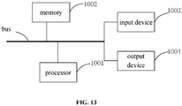
- FIG. 13 it is a block diagram showing an electronic apparatus applied with a method according to an embodiment of the present application.
- the electronic apparatus is intended to represent various forms of digital computers, such as laptop computers, desktop computers, workbenches, personal digital assistants, servers, blade servers, mainframe computers, and other suitable computers.
- the electronic apparatus may also represent various forms of mobile devices, such as personal digital processors, cellular phones, intelligent phones, wearable devices, and other similar computing devices.
- Components shown in the present application, their connections and relations, and their functions are merely examples, and are not intended to limit the implementation of the application described and/or required herein.
- the electronic apparatus includes: one or more processors 1001, a memory 1002, and interfaces for connecting various components, including a high-speed interface and a low-speed interface.
- the various components are interconnected using different buses and may be mounted on a common motherboard or otherwise installed as required.
- the processor may process instructions executed within the electronic apparatus, including instructions for storing in or on a memory, to display graphical information of a Graphical User Interface (GUI) on an external input/output device (such as a display device coupled to the interface).
- GUI Graphical User Interface
- multiple processors and/or multiple buses may be used with multiple memories and multiple memories, if desired.
- multiple electronic apparatuses may be connected, each apparatus providing some of the necessary operations (for example, as a server array, a group of blade servers, or a multiprocessor system).
- one processor 1001 is shown as an example.
- the memory 1002 is a non-transitory computer-readable storage medium provided in the present application.
- the memory stores instructions executable by at least one processor, so that the at least one processor executes a method provided in the present application.
- the non-transitory computer-readable storage medium of the present application stores computer instructions, which are configured to enable a computer to execute a method provided in the present application.
- the memory 1002 may be used to store non-transitory software programs, non-transitory computer executable programs, and modules, such as program instructions/modules corresponding to a method in embodiments of the present application.
- the processor 1001 executes various functional applications and data processing of the server by running non-transitory software programs, instructions, and modules stored in the memory 1002, that is, to implement an above method in foregoing method embodiments.
- the memory 1002 may include a storage program area and a storage data area, where the storage program area may be used to store an application program required by an operating system or for at least one function; the storage data area may be used to store data created according to the use of an electronic device applied with a method in any one of above embodiments of the present application.
- the memory 1002 may include a high-speed random-access memory, and may also include a non-transitory memory, such as at least one magnetic disk storage device, a flash memory device, or other non-transitory solid-state storage device.
- the memory 1002 may optionally include a memory set remotely relative to the processor 1001, and these remote memories may be connected to the electronic apparatus applied with a method in any one of above embodiments of the present application through a network.
- Examples of the above network include, but are not limited to, an Internet, an intranet, a local area network, a mobile communication network, and combinations thereof.
- An electronic apparatus applied with a method according to an embodiment of the present application may further include an input device 1003 and an output device 1004.
- the processor 1001, the memory 1002, the input device 1003, and the output device 1004 may be connected through a bus or in other manners. In FIG. 13 , a connection through a bus is shown as an example.
- the input device 1003 may receive input numeric or character information, and generate key signal inputs related to a user setting and a function control of an electronic apparatus applied with a method in any one of above embodiments of the present application, such as a touch screen, a keypad, a mouse, a trackpad, a touchpad, a pointing stick, one or more mouse buttons, a trackball, a joystick and other input devices.
- the output device 1004 may include a display device, an auxiliary lighting device (for example, an LED), a haptic feedback device (for example, a vibration motor), and the like.
- the display device may include, but is not limited to, a Liquid Crystal Display (LCD), a Light Emitting Diode (LED) display, and a plasma display. In some implementations, the display device may be a touch screen.
- implementations of the systems and technologies described herein may be implemented in a digital electronic circuit system, an integrated circuit system, an application specific integrated circuit (ASIC), a computer hardware, a firmware, a software, and/or combinations thereof.
- ASIC application specific integrated circuit
- These various implementations may include: implementations in one or more computer programs, where the one or more computer programs are executable and/or interpretable on a programmable system including at least one programmable processor, programmable processor, where the programmable processor may be a dedicated or general-purpose programmable processor that may receive data and instructions from a storage system, at least one input device, and at least one output device, and may transmit the data and instructions to the storage system, the at least one input device, and the at least one output device.
- machine-readable medium and “computer-readable medium” refer to any computer program product, apparatus, and/or device used to provide machine instructions and/or data to a programmable processor (for example, a magnetic disk, an optical disk, a memory, and a programmable logic device (PLD)), including machine-readable media that receives machine instructions as machine-readable signals.
- machine-readable signal refers to any signal used to provide machine instructions and/or data to a programmable processor.
- systems and techniques described herein may be implemented on a computer, where the computer includes: a display device (for example, a Cathode Ray Tube (CRT) or liquid crystal display (LCD) monitor) for displaying information to a user; and a keyboard and pointing device (such as a mouse or a trackball) through which a user may provide input to a computer.
- a display device for example, a Cathode Ray Tube (CRT) or liquid crystal display (LCD) monitor
- LCD liquid crystal display
- keyboard and pointing device such as a mouse or a trackball
- Other kinds of devices may also be used to provide interaction with a user.
- a feedback provided to a user may be a sensory feedback in any form (for example, a visual feedback, an auditory feedback, or a haptic feedback), and a user input (including an acoustic input, a voice input, or a tactile input) may be received in any form.
- the systems and technologies described herein may be implemented in a computing system including a background component (for example, as a data server), a computing system including a middleware component (for example, an application server), or a computing system including a front-end component (for example, a user computer with a graphical user interface or a web browser, through which the user may interact with an implementation of the systems and technologies described herein), or a computer system including any combination of such a background component, a middleware component, or a front-end component.
- the components of the system may be interconnected by any form or medium of digital data communication (such as, a communication network). Examples of a communication network include a Local Area Network (LAN), a Wide Area Network (WAN), and the Internet.
- LAN Local Area Network
- WAN Wide Area Network
- the Internet the global information network
Landscapes
- Engineering & Computer Science (AREA)
- Radar, Positioning & Navigation (AREA)
- Remote Sensing (AREA)
- Automation & Control Theory (AREA)
- General Physics & Mathematics (AREA)
- Physics & Mathematics (AREA)
- General Health & Medical Sciences (AREA)
- Health & Medical Sciences (AREA)
- Multimedia (AREA)
- Audiology, Speech & Language Pathology (AREA)
- Transportation (AREA)
- Mechanical Engineering (AREA)
- Social Psychology (AREA)
- Computer Vision & Pattern Recognition (AREA)
- Theoretical Computer Science (AREA)
- Navigation (AREA)
- Traffic Control Systems (AREA)
- Instructional Devices (AREA)
Applications Claiming Priority (1)
| Application Number | Priority Date | Filing Date | Title |
|---|---|---|---|
| CN202010508170.6A CN111595358B (zh) | 2020-06-05 | 2020-06-05 | 导航数据处理方法、路径诱导方法、设备及存储介质 |
Publications (3)
| Publication Number | Publication Date |
|---|---|
| EP3842764A2 true EP3842764A2 (de) | 2021-06-30 |
| EP3842764A3 EP3842764A3 (de) | 2022-04-20 |
| EP3842764B1 EP3842764B1 (de) | 2026-02-11 |
Family
ID=72188388
Family Applications (1)
| Application Number | Title | Priority Date | Filing Date |
|---|---|---|---|
| EP21164555.1A Active EP3842764B1 (de) | 2020-06-05 | 2021-03-24 | Verfahren zur verarbeitung von navigationsdaten, pfadführungsverfahren, vorrichtung und speichermedium |
Country Status (5)
| Country | Link |
|---|---|
| US (1) | US11645854B2 (de) |
| EP (1) | EP3842764B1 (de) |
| JP (1) | JP7278320B2 (de) |
| KR (1) | KR102619042B1 (de) |
| CN (1) | CN111595358B (de) |
Families Citing this family (48)
| Publication number | Priority date | Publication date | Assignee | Title |
|---|---|---|---|---|
| WO2020240274A1 (en) * | 2019-05-28 | 2020-12-03 | Mobileye Vision Technologies Ltd. | Systems and methods for vehicle navigation |
| CN112069280A (zh) * | 2020-09-04 | 2020-12-11 | 中国平安财产保险股份有限公司 | 道路数据处理方法、装置、设备及存储介质 |
| CN112577508B (zh) * | 2020-12-02 | 2022-03-08 | 武汉光庭信息技术股份有限公司 | 一种高精度道路导航道路计算方法及系统 |
| CN112732844B (zh) * | 2021-01-26 | 2022-09-23 | 腾讯科技(深圳)有限公司 | 将道路对象与道路自动关联的方法、装置、设备和介质 |
| KR102311826B1 (ko) * | 2021-02-18 | 2021-10-13 | 웨이즈원 주식회사 | 교통신호현시정보 서비스용 메시지 생성 장치 및 방법 |
| CN115218910B (zh) * | 2021-04-19 | 2025-03-25 | 逢甲大学 | 虚拟导航路径生成方法 |
| CN115495536B (zh) * | 2021-06-18 | 2026-02-06 | 高德软件有限公司 | 数据处理方法、装置、电子设备及计算机存储介质 |
| JP7538880B2 (ja) | 2021-06-29 | 2024-08-22 | ベイジン バイドゥ ネットコム サイエンス テクノロジー カンパニー リミテッド | 車線レベルのナビゲーション地図の構築方法、装置、機器および記憶媒体 |
| CN113390407A (zh) * | 2021-06-29 | 2021-09-14 | 北京百度网讯科技有限公司 | 车道级导航地图的构建方法、装置、设备以及存储介质 |
| CN113405561B (zh) * | 2021-07-06 | 2022-11-25 | 文诚恒远(天津)供应链管理服务有限公司 | 一种驾驶路线的推荐方法、装置、设备及存储介质 |
| CN113670308B (zh) * | 2021-07-14 | 2024-01-02 | 华为技术有限公司 | 引导车辆行驶的方法及相关系统、存储介质 |
| CN113327447B (zh) * | 2021-07-20 | 2022-08-19 | 北京百度网讯科技有限公司 | 导航提醒方法、装置、设备、车辆及存储介质 |
| CN113689715B (zh) * | 2021-07-20 | 2023-04-28 | 新奇点智能科技集团有限公司 | 信息推送方法、装置、电子设备及计算机可读存储介质 |
| CN113607182B (zh) * | 2021-08-05 | 2024-08-20 | 北京中交兴路信息科技有限公司 | 一种车辆行驶路线导航方法、装置、存储介质及终端 |
| JP2023033715A (ja) * | 2021-08-30 | 2023-03-13 | 株式会社Gsec | 道路網の定義方法、経路設定方法、情報処理装置、情報処理プログラム及び道路網の定義情報 |
| CN114023095B (zh) * | 2021-09-22 | 2022-12-30 | 北京百度网讯科技有限公司 | 一种交通限制识别方法、装置及电子设备 |
| US20240311400A1 (en) * | 2021-09-30 | 2024-09-19 | Beijing Baidu Netcom Science Technology Co., Ltd. | Traffic restriction identification method and electronic device |
| CN114020856A (zh) * | 2021-09-30 | 2022-02-08 | 北京百度网讯科技有限公司 | 一种交通限制识别方法、装置及电子设备 |
| CN114136327B (zh) * | 2021-11-22 | 2023-08-01 | 武汉中海庭数据技术有限公司 | 一种虚线段的查全率的自动化检查方法及系统 |
| CN116246477B (zh) * | 2021-12-08 | 2025-11-21 | 腾讯科技(深圳)有限公司 | 一种导航提示方法、装置、电子设备及存储介质 |
| CN114201568B (zh) * | 2021-12-10 | 2025-08-01 | 北京百度网讯科技有限公司 | 信息处理方法、生成方法、装置、电子设备以及存储介质 |
| JP7835078B2 (ja) * | 2021-12-14 | 2026-03-25 | 富士電機株式会社 | 電力変換装置 |
| CN114353815A (zh) * | 2021-12-16 | 2022-04-15 | 阿里巴巴新加坡控股有限公司 | 导航方法、装置、设备及计算机程序产品 |
| CN114332822B (zh) * | 2021-12-31 | 2025-02-21 | 北京百度网讯科技有限公司 | 确定车道组类型的方法、装置及电子设备 |
| CN114485705B (zh) * | 2022-01-12 | 2024-05-14 | 上海于万科技有限公司 | 一种基于路网地图的清扫路径确定方法及系统 |
| CN114674340B (zh) * | 2022-03-21 | 2025-02-21 | 北京百度网讯科技有限公司 | 地图数据的处理方法、装置、电子设备和存储介质 |
| CN114877912A (zh) * | 2022-04-27 | 2022-08-09 | 云控智行科技有限公司 | 一种车辆导航信息生成方法、装置及设备 |
| CN114792476B (zh) * | 2022-04-28 | 2024-03-05 | 北京百度网讯科技有限公司 | 导航播报方法、装置、电子设备和存储介质 |
| CN114863047B (zh) * | 2022-05-06 | 2025-06-27 | 高德软件有限公司 | 路口虚拟线绘制方法、装置、电子设备及计算机程序产品 |
| CN114889611B (zh) * | 2022-05-25 | 2024-05-14 | 重庆长安汽车股份有限公司 | 基于自学习的路口车道选择的控制系统及方法 |
| CN114724377B (zh) * | 2022-06-01 | 2022-10-18 | 华砺智行(武汉)科技有限公司 | 基于车路协同技术的无人驾驶车辆引导方法及系统 |
| CN117290570A (zh) * | 2022-06-17 | 2023-12-26 | 北京罗克维尔斯科技有限公司 | 导航路网数据生成方法、装置、设备及存储介质 |
| CN114879705B (zh) * | 2022-07-13 | 2022-10-28 | 智道网联科技(北京)有限公司 | 无人车变道的路径优化方法、设备和计算机可读存储介质 |
| CN115564097A (zh) * | 2022-09-08 | 2023-01-03 | 中铁十九局集团矿业投资有限公司 | 一种煤矿复杂条件下道路结构维护治理方法 |
| CN115683133B (zh) * | 2022-09-28 | 2025-04-25 | 武汉中海庭数据技术有限公司 | 一种高精度地图车道组平齐切割方法及系统 |
| CN115617934B (zh) * | 2022-10-17 | 2025-10-28 | 武汉中海庭数据技术有限公司 | 一种高精度地图车道组作用范围生成方法及系统 |
| CN115631476A (zh) * | 2022-10-19 | 2023-01-20 | 重庆长安汽车股份有限公司 | 一种车道数据处理方法、系统、电子设备及存储介质 |
| CN115690716A (zh) * | 2022-11-14 | 2023-02-03 | 智道网联科技(北京)有限公司 | 车道变化检测方法、装置及电子设备、存储介质 |
| CN115752440B (zh) * | 2022-11-23 | 2025-04-29 | 武汉中海庭数据技术有限公司 | 地物车道关联关系的筛选方法及系统 |
| US12286132B2 (en) * | 2022-12-08 | 2025-04-29 | GM Global Technology Operations LLC | Vehicle systems and methods for autonomous route following |
| CN116412812B (zh) * | 2023-03-28 | 2025-07-25 | 重庆长安汽车股份有限公司 | 车道面关系的配置方法及装置、存储介质、电子装置 |
| CN116734875A (zh) * | 2023-05-17 | 2023-09-12 | 斑马网络技术有限公司 | 一种智能汽车车道级导航语音播报方法及系统 |
| CN117163054B (zh) * | 2023-08-30 | 2024-03-12 | 广州方驰信息科技有限公司 | 一种用于虚拟实景视频融合的大数据分析系统及方法 |
| US12589767B2 (en) * | 2024-01-31 | 2026-03-31 | Toyota Jidosha Kabushiki Kaisha | Systems and methods for generating a driving trajectory |
| CN118746311B (zh) * | 2024-08-20 | 2025-01-14 | 比亚迪股份有限公司 | 车道推荐方法、存储介质、电子设备及目标车辆 |
| CN118710767B (zh) * | 2024-08-27 | 2024-12-06 | 浙江吉利控股集团有限公司 | 弯道虚线处理方法、装置、设备、介质及程序产品 |
| EP4730305A1 (de) * | 2024-10-18 | 2026-04-22 | TomTom Global Content B.V. | Verfahren, vorrichtung und computerprogramm zur erzeugung von kartendaten |
| CN120609376B (zh) * | 2025-05-30 | 2026-04-07 | 联通智网科技股份有限公司 | 车辆的行驶路径规划方法、装置、设备、存储介质及程序产品 |
Citations (1)
| Publication number | Priority date | Publication date | Assignee | Title |
|---|---|---|---|---|
| US20180149488A1 (en) * | 2016-11-29 | 2018-05-31 | Alpine Electronics, Inc. | Guide route setting apparatus and guide route setting method |
Family Cites Families (15)
| Publication number | Priority date | Publication date | Assignee | Title |
|---|---|---|---|---|
| JP4770702B2 (ja) * | 2006-10-31 | 2011-09-14 | アイシン・エィ・ダブリュ株式会社 | 経路案内システム及び経路案内方法 |
| JP4861850B2 (ja) | 2007-02-13 | 2012-01-25 | アイシン・エィ・ダブリュ株式会社 | レーン判定装置及びレーン判定方法 |
| US9689701B2 (en) * | 2010-07-23 | 2017-06-27 | Mitsubishi Electric Corporation | Navigation device |
| CN102162734B (zh) | 2011-01-11 | 2012-11-07 | 厦门雅迅网络股份有限公司 | 一种生成导航电子地图数据的方法 |
| US10637683B2 (en) * | 2016-12-23 | 2020-04-28 | Centurylink Intellectual Property Llc | Smart city apparatus, system, and method |
| US11307591B2 (en) | 2017-01-24 | 2022-04-19 | Honda Motor Co., Ltd. | Vehicle control system, vehicle control method, and vehicle control program |
| JP6789863B2 (ja) * | 2017-03-23 | 2020-11-25 | 株式会社日立製作所 | 移動体、移動体制御システム及び移動体制御方法 |
| CN108801273B (zh) * | 2017-04-28 | 2021-07-30 | 阿里巴巴(中国)有限公司 | 一种道路参考线的生成方法及装置 |
| CN108151751B (zh) * | 2017-11-21 | 2020-04-21 | 武汉中海庭数据技术有限公司 | 一种基于高精度地图和传统地图结合的路径规划方法及装置 |
| US10895468B2 (en) | 2018-04-10 | 2021-01-19 | Toyota Jidosha Kabushiki Kaisha | Dynamic lane-level vehicle navigation with lane group identification |
| US11255679B2 (en) * | 2018-04-19 | 2022-02-22 | Uatc, Llc | Global and local navigation for self-driving |
| US10761535B2 (en) * | 2018-08-21 | 2020-09-01 | GM Global Technology Operations LLC | Intelligent vehicle navigation systems, methods, and control logic for multi-lane separation and trajectory extraction of roadway segments |
| CN109785667B (zh) * | 2019-03-11 | 2021-08-03 | 百度在线网络技术(北京)有限公司 | 车道偏离识别方法、装置、设备和存储介质 |
| CN110375764A (zh) * | 2019-07-16 | 2019-10-25 | 中国第一汽车股份有限公司 | 变道提示方法、系统、车辆及存储介质 |
| CN110954128B (zh) * | 2019-12-03 | 2021-11-16 | 阿波罗智能技术(北京)有限公司 | 检测车道线位置变化的方法、装置、电子设备和存储介质 |
-
2020
- 2020-06-05 CN CN202010508170.6A patent/CN111595358B/zh active Active
- 2020-12-04 US US17/112,203 patent/US11645854B2/en active Active
-
2021
- 2021-03-16 KR KR1020210033936A patent/KR102619042B1/ko active Active
- 2021-03-22 JP JP2021047747A patent/JP7278320B2/ja active Active
- 2021-03-24 EP EP21164555.1A patent/EP3842764B1/de active Active
Patent Citations (1)
| Publication number | Priority date | Publication date | Assignee | Title |
|---|---|---|---|---|
| US20180149488A1 (en) * | 2016-11-29 | 2018-05-31 | Alpine Electronics, Inc. | Guide route setting apparatus and guide route setting method |
Also Published As
| Publication number | Publication date |
|---|---|
| EP3842764B1 (de) | 2026-02-11 |
| US11645854B2 (en) | 2023-05-09 |
| JP2021092592A (ja) | 2021-06-17 |
| EP3842764A3 (de) | 2022-04-20 |
| US20210383136A1 (en) | 2021-12-09 |
| JP7278320B2 (ja) | 2023-05-19 |
| KR102619042B1 (ko) | 2023-12-27 |
| KR20210151676A (ko) | 2021-12-14 |
| CN111595358A (zh) | 2020-08-28 |
| CN111595358B (zh) | 2022-03-29 |
Similar Documents
| Publication | Publication Date | Title |
|---|---|---|
| US11645854B2 (en) | Method for processing navigation data, path guidance method, apparatus and storage medium | |
| CN111081046B (zh) | 一种自动驾驶车辆变道方法、装置、电子设备和介质 | |
| US11724716B2 (en) | Method and apparatus of determining guide path, method and apparatus of controlling driving of vehicle, and electronic device | |
| US11741690B2 (en) | Method for generating parking model, electronic device, and storage medium | |
| US11447153B2 (en) | Method and apparatus for annotating virtual lane at crossing | |
| CN112164238B (zh) | 导航变道引导方法、装置、设备和存储介质 | |
| CN114572240B (zh) | 车辆行驶控制方法、装置、车辆、电子设备及存储介质 | |
| CN111216738B (zh) | 自动驾驶中车辆的控制方法、装置、电子设备及车辆 | |
| CN113223113B (zh) | 车道线处理方法、装置、电子设备和云控平台 | |
| CN111443709B (zh) | 车辆变道路线规划方法、装置、终端和存储介质 | |
| WO2022142849A1 (zh) | 导航提示信息的生成方法、提醒方法、装置及设备 | |
| CN110751825B (zh) | 编队行驶的避让方法、装置、设备和计算机可读存储介质 | |
| CN115050008B (zh) | 路口虚拟车道线确定方法、装置、电子设备及存储介质 | |
| CN111353466B (zh) | 车道线识别处理方法、设备、存储介质 | |
| CN112622924B (zh) | 一种驾驶规划方法及装置、车辆 | |
| JP7104215B2 (ja) | オフラインマップの生成方法、生成装置、電子機器及び記憶媒体 | |
| CN111540010B (zh) | 一种道路监测的方法、装置、电子设备及存储介质 | |
| CN111652112B (zh) | 一种车道流向的识别方法、装置、电子设备及存储介质 | |
| CN111998861B (zh) | 车辆提示方法、装置、设备以及存储介质 | |
| CN117842097A (zh) | 基于自动驾驶的车辆控制方法、装置、设备及存储介质 | |
| CN115535003A (zh) | 自动驾驶车辆的路口控制方法、装置、电子设备和介质 | |
| CN111750889A (zh) | 路径导航的方法、装置、电子设备及可读存储介质 | |
| CN111027423B (zh) | 一种自动驾驶车道线检测方法、装置和电子设备 | |
| CN115771526A (zh) | 自动驾驶中控制车辆左转的方法、装置与自动驾驶车辆 | |
| CN114792476B (zh) | 导航播报方法、装置、电子设备和存储介质 |
Legal Events
| Date | Code | Title | Description |
|---|---|---|---|
| PUAI | Public reference made under article 153(3) epc to a published international application that has entered the european phase |
Free format text: ORIGINAL CODE: 0009012 |
|
| STAA | Information on the status of an ep patent application or granted ep patent |
Free format text: STATUS: REQUEST FOR EXAMINATION WAS MADE |
|
| 17P | Request for examination filed |
Effective date: 20210324 |
|
| AK | Designated contracting states |
Kind code of ref document: A2 Designated state(s): AL AT BE BG CH CY CZ DE DK EE ES FI FR GB GR HR HU IE IS IT LI LT LU LV MC MK MT NL NO PL PT RO RS SE SI SK SM TR |
|
| RIC1 | Information provided on ipc code assigned before grant |
Ipc: G01C 21/32 20060101ALI20211012BHEP Ipc: G01C 21/36 20060101AFI20211012BHEP |
|
| PUAL | Search report despatched |
Free format text: ORIGINAL CODE: 0009013 |
|
| AK | Designated contracting states |
Kind code of ref document: A3 Designated state(s): AL AT BE BG CH CY CZ DE DK EE ES FI FR GB GR HR HU IE IS IT LI LT LU LV MC MK MT NL NO PL PT RO RS SE SI SK SM TR |
|
| RIC1 | Information provided on ipc code assigned before grant |
Ipc: G01C 21/32 20060101ALI20220318BHEP Ipc: G01C 21/36 20060101AFI20220318BHEP |
|
| STAA | Information on the status of an ep patent application or granted ep patent |
Free format text: STATUS: EXAMINATION IS IN PROGRESS |
|
| 17Q | First examination report despatched |
Effective date: 20231208 |
|
| RIC1 | Information provided on ipc code assigned before grant |
Ipc: G01C 21/36 20060101AFI20250630BHEP Ipc: G01C 21/32 20060101ALI20250630BHEP Ipc: G01C 21/00 20060101ALI20250630BHEP |
|
| GRAP | Despatch of communication of intention to grant a patent |
Free format text: ORIGINAL CODE: EPIDOSNIGR1 |
|
| STAA | Information on the status of an ep patent application or granted ep patent |
Free format text: STATUS: GRANT OF PATENT IS INTENDED |
|
| INTG | Intention to grant announced |
Effective date: 20250904 |
|
| GRAS | Grant fee paid |
Free format text: ORIGINAL CODE: EPIDOSNIGR3 |
|
| GRAA | (expected) grant |
Free format text: ORIGINAL CODE: 0009210 |
|
| STAA | Information on the status of an ep patent application or granted ep patent |
Free format text: STATUS: THE PATENT HAS BEEN GRANTED |
|
| AK | Designated contracting states |
Kind code of ref document: B1 Designated state(s): AL AT BE BG CH CY CZ DE DK EE ES FI FR GB GR HR HU IE IS IT LI LT LU LV MC MK MT NL NO PL PT RO RS SE SI SK SM TR |
|
| REG | Reference to a national code |
Ref country code: CH Ref legal event code: F10 Free format text: ST27 STATUS EVENT CODE: U-0-0-F10-F00 (AS PROVIDED BY THE NATIONAL OFFICE) Effective date: 20260211 Ref country code: GB Ref legal event code: FG4D |
|
| REG | Reference to a national code |
Ref country code: DE Ref legal event code: R096 Ref document number: 602021047593 Country of ref document: DE |
|
| REG | Reference to a national code |
Ref country code: IE Ref legal event code: FG4D |
|
| P01 | Opt-out of the competence of the unified patent court (upc) registered |
Free format text: CASE NUMBER: UPC_APP_0004688_3842764/2026 Effective date: 20260209 |
|
| PGFP | Annual fee paid to national office [announced via postgrant information from national office to epo] |
Ref country code: DE Payment date: 20260319 Year of fee payment: 6 |