EP3844523B1 - Procédés d'optimisation dans la géolocalisation à l'aide d'un équipement de mesure de distance électronique - Google Patents
Procédés d'optimisation dans la géolocalisation à l'aide d'un équipement de mesure de distance électronique Download PDFInfo
- Publication number
- EP3844523B1 EP3844523B1 EP19780389.3A EP19780389A EP3844523B1 EP 3844523 B1 EP3844523 B1 EP 3844523B1 EP 19780389 A EP19780389 A EP 19780389A EP 3844523 B1 EP3844523 B1 EP 3844523B1
- Authority
- EP
- European Patent Office
- Prior art keywords
- node
- nodes
- list
- confidence
- tag
- Prior art date
- Legal status (The legal status is an assumption and is not a legal conclusion. Google has not performed a legal analysis and makes no representation as to the accuracy of the status listed.)
- Active
Links
Images


Classifications
-
- G—PHYSICS
- G01—MEASURING; TESTING
- G01S—RADIO DIRECTION-FINDING; RADIO NAVIGATION; DETERMINING DISTANCE OR VELOCITY BY USE OF RADIO WAVES; LOCATING OR PRESENCE-DETECTING BY USE OF THE REFLECTION OR RERADIATION OF RADIO WAVES; ANALOGOUS ARRANGEMENTS USING OTHER WAVES
- G01S5/00—Position-fixing by co-ordinating two or more direction or position line determinations; Position-fixing by co-ordinating two or more distance determinations
- G01S5/02—Position-fixing by co-ordinating two or more direction or position line determinations; Position-fixing by co-ordinating two or more distance determinations using radio waves
- G01S5/0205—Details
- G01S5/0244—Accuracy or reliability of position solution or of measurements contributing thereto
-
- G—PHYSICS
- G01—MEASURING; TESTING
- G01S—RADIO DIRECTION-FINDING; RADIO NAVIGATION; DETERMINING DISTANCE OR VELOCITY BY USE OF RADIO WAVES; LOCATING OR PRESENCE-DETECTING BY USE OF THE REFLECTION OR RERADIATION OF RADIO WAVES; ANALOGOUS ARRANGEMENTS USING OTHER WAVES
- G01S5/00—Position-fixing by co-ordinating two or more direction or position line determinations; Position-fixing by co-ordinating two or more distance determinations
- G01S5/02—Position-fixing by co-ordinating two or more direction or position line determinations; Position-fixing by co-ordinating two or more distance determinations using radio waves
- G01S5/0205—Details
-
- G—PHYSICS
- G01—MEASURING; TESTING
- G01S—RADIO DIRECTION-FINDING; RADIO NAVIGATION; DETERMINING DISTANCE OR VELOCITY BY USE OF RADIO WAVES; LOCATING OR PRESENCE-DETECTING BY USE OF THE REFLECTION OR RERADIATION OF RADIO WAVES; ANALOGOUS ARRANGEMENTS USING OTHER WAVES
- G01S5/00—Position-fixing by co-ordinating two or more direction or position line determinations; Position-fixing by co-ordinating two or more distance determinations
- G01S5/02—Position-fixing by co-ordinating two or more direction or position line determinations; Position-fixing by co-ordinating two or more distance determinations using radio waves
- G01S5/0284—Relative positioning
-
- G—PHYSICS
- G01—MEASURING; TESTING
- G01S—RADIO DIRECTION-FINDING; RADIO NAVIGATION; DETERMINING DISTANCE OR VELOCITY BY USE OF RADIO WAVES; LOCATING OR PRESENCE-DETECTING BY USE OF THE REFLECTION OR RERADIATION OF RADIO WAVES; ANALOGOUS ARRANGEMENTS USING OTHER WAVES
- G01S5/00—Position-fixing by co-ordinating two or more direction or position line determinations; Position-fixing by co-ordinating two or more distance determinations
- G01S5/02—Position-fixing by co-ordinating two or more direction or position line determinations; Position-fixing by co-ordinating two or more distance determinations using radio waves
- G01S5/14—Determining absolute distances from a plurality of spaced points of known location
-
- G—PHYSICS
- G01—MEASURING; TESTING
- G01S—RADIO DIRECTION-FINDING; RADIO NAVIGATION; DETERMINING DISTANCE OR VELOCITY BY USE OF RADIO WAVES; LOCATING OR PRESENCE-DETECTING BY USE OF THE REFLECTION OR RERADIATION OF RADIO WAVES; ANALOGOUS ARRANGEMENTS USING OTHER WAVES
- G01S5/00—Position-fixing by co-ordinating two or more direction or position line determinations; Position-fixing by co-ordinating two or more distance determinations
- G01S5/02—Position-fixing by co-ordinating two or more direction or position line determinations; Position-fixing by co-ordinating two or more distance determinations using radio waves
- G01S5/0284—Relative positioning
- G01S5/0289—Relative positioning of multiple transceivers, e.g. in ad hoc networks
Definitions
- the present invention relates to methods for geolocation utilizing electronic distance measurement equipment.
- Geolocation using distance measurement equipment employs a plurality of distance measurements from a node to other nearby nodes with known positions in order to determine the local node's position.
- Many such systems are known in the art.
- Known methods usually attempt to obtain as many such measurements as possible in order to reduce error by averaging, filtering and other statistical and numerical techniques. Accuracy of position in such systems is improved with increased number of nodes, which makes it desirable to have as many nodes as possible.
- a node can only measure the distance to one other node at a time. Further, unless multiple channels are used, only one pair of nodes within range of radio transmissions can be measuring the distance between them at any given time, to avoid interference from other nodes using the same radio spectrum. Multiple scheduling and arbitration techniques are well known and practiced in the art, including TDMA, CDMA and others.
- methods of geolocation are disclosed that select a small subset of only the most favorable measurements among all that are available, based on the disclosed Confidence metric and the geometry of the relative positions of available nodes.
- only at most three measurements are used to determine the Position of any given node in accordance with the disclosed methods, while the rest are discarded.
- only at most (N*3)/2 measurements are actually used, providing potentially linear scalability as opposed to exponential for conventional approaches. What is needed is a means of determining in advance which measurements are likely to be the most favorable and only performing the requested measurements, greatly reducing the radio usage as a result.
- the present invention teaches methods that provide the desired means.
- Document US2007005292 describes adaptive rule-based methods to solve localization problems for ad hoc wireless sensor networks. The methods scale well and provide improved positioning accuracy. A dynamic version may be used for estimating moving sensors locations in a real-time environment.
- Document US2006050651 describes a method of determining coordinates for nodes in a network. In response to a node being selected, the node broadcasts a request to other nodes for respective coordinate information of the other nodes.
- the primary objective of the present invention is to significantly reduce the radio utilization required for accurate peer-to-peer geolocation of a plurality of nodes, in order to improve scalability and overall system response.
- the present invention achieves its objective by disclosing methods comprising a sequence of steps, starting with determining which among a set of available neighboring nodes would provide the most favorable distance measurements for determining a node's position, selecting only those nodes for distance measurement, and then performing only the selected distance measurements.
- the invention relates to a method of determining a new Position for a Node n, said Node having a distance measuring radio, said method comprising the steps of:
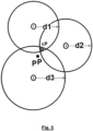
- the selection in step c) is based on most favorable geometric relationship of Nodes in said list to the predicted Position of Node n.
- the number of Nodes selected in step c) is at most 3.
- the method further comprises step f) transmitting said measured distances to said subset of Nodes.
- step a) further comprises receiving a previously measured distance from at least one among a plurality of neighboring Nodes, and comprising step d) Performing electronic distance measurements from Node n to each of said subset of Nodes for which a previously measured distance was not received in step a).
- the illustrative embodiment presented herein utilizes in part the methods disclosed in the above referenced co-pending application, in particular the methods for selecting a subset of Nodes based on geometry and Confidence, and the methods for determining the Position of Node n having two or three distance measurements to other Nodes. These methods are included in the following description for reference, however they are outside the scope of the present invention.
- the scope of the present invention pertains specifically to the sequence of first selecting a subset of Nodes from a plurality of available Nodes, subsequently performing distance measurements only to the selected nodes, and then determining a Node's Position based on said measurements, by any known or future method.
- Fig. 1 is a diagram of the overall data flow for an illustrative embodiment of the present invention.
- IMU inertial measurement unit
- magnetometer magnetometer
- altimeter altimeter
- the IMU and altimeter are contained within the hardware portion of a node.
- Information about the locations of neighboring nodes is transmitted to the node via a data radio.
- a single node will be designated as the Neighborhood Manager responsible for periodically collecting and dissiminating this information among the nodes.
- this information may be tranferred collaboratively peer-to-peer. Many methods for transferring information among a plurality of nodes are known. The details of such methods are outside the scope of the present invention.
- Distance measurements between nodes are performed by means of a distance measuring radio.
- a number of such methods are known.
- the illustrated embodiment utilizes Decawave DW1000 distance measuring radios, but a number of others are readily available.
- Confidence Key positioning values such as the coordinates and distances have an associated confidence value with a range of 0.0 to 1.0 where 0.0 indicates no confidence and 1.0 indicates absolute confidence. Other numeric scales can be used in different embodiments. Whenever positioning chooses among Node data for calculating a position estimate, it uses the confidence of the data to choose the best (most confident) data.
- a tag's confidence is calculated based on the confidence of the data is receives from sensors, distance measurement and neighbor Nodes used to calculate a tag's position.
- a tag's Position confidence can decrease over time due to data errors, lack of Precision, and time lag between data updates; confidence decreases with data age. As mentioned above, the confidence never increases on its own, it can only increase if the confidence of incoming new data is higher than currently available data.
- Positioning consists of the following modules:
- GEO Geometry Module
- GEO recalculates the estimated position at the same rate as Distance measurement is able to provide distances updates.
- Each Node implementation may have different Distance measurement technology and thus the update rates vary by Node.
- INS Inertial Navigation Module
- INS takes inertial inputs from the IMU and converts them X and Y offsets and adds them to the previous position to compute a new predicted Position and associated Confidence.
- a large amount of inertial activity will reduce Confidence, while little or no detected inertial activity will, in some embodiments, increase Confidence.
- a second function of the INS is to receive a list of geometric candidate Positions from the GEO module, and select among them based on distance from predicted Position and relative Confidence.
- the predicted Position may be selected over all candidate Positions.
- a new position may be calculated that is a weighted average of the closest candidate Position and predicted Position, with weights being at least in part proportional to respective Confidence.
- MOT takes inertial inputs from INS and computes whether the local Node is in motion and it computes the direction of travel (bearing). The result of motion computation is used to adjust Confidence of the node's Position and also is used to switch node roles between Anchor, Breadcrumb and Tag. Node roles are used by the GEO module as criteria for selecting most favorable sets of distance measurements, with the highest preference being given to Anchors, then Breadcrumbs, then Tags.
- a Breadcrumb within the context of the illustrated embodiment, is a Tag that has been stationary for an extended period of time. The primary difference between an Anchor and a Breadcrumb, in the illustrated embodiment, is that an Anchor's position is explicitly known and assigned when the Anchor is placed. A Breadcrumb's position was calculated when it was moving as a Tag, but has higher Confidence than that of a moving Tag due to having been stationary and having the benefit of a number of repetitive measurements being considered over time to reduce error.
Landscapes
- Physics & Mathematics (AREA)
- Engineering & Computer Science (AREA)
- General Physics & Mathematics (AREA)
- Radar, Positioning & Navigation (AREA)
- Remote Sensing (AREA)
- Position Fixing By Use Of Radio Waves (AREA)
- Radar Systems Or Details Thereof (AREA)
Claims (6)
- Procédé de détermination d'une nouvelle position d'un noeud n, ledit noeud n comportant une radio de mesure de distance, ledit procédé comprenant les étapes suivantes :a) obtenir une liste de positions d'une pluralité de noeuds voisins,b) analyser la relation géométrique entre les positions dans ladite liste et la position prédite (pP) du noeud n,c) sélectionner un sous-ensemble de noeuds dans ladite liste qui est inférieur au nombre total de noeuds dans ladite liste,d) effectuer des mesures de distance électroniques du noeud n à chacun desdits sous-ensembles de noeuds,e) utiliser les distances obtenues à l'étape d) pour déterminer une nouvelle position du noeud n,l'étape a) comprenant en outre l'obtention de métriques de confiance correspondantes pour chacune desdites positions dans ladite liste, et la sélection à l'étape c) étant basée au moins en partie sur lesdites métriques de confiance,caractérisé en ce que le procédé comprend en outre l'étape de calcul, avec prise en compte d'entrées inertielles d'un système de navigation inertielle, INS, si un noeud est en mouvement et de calcul de la direction de déplacement, le résultat du calcul de mouvement étant utilisé pour ajuster la confiance de la position du noeud et pour commuter les rôles de noeud entre ceux d'ancre, de fil d'Ariane et de balise,les rôles de noeud étant utilisés comme critères de sélection d'ensembles de mesures de distance les plus favorables, la préférence la plus élevée étant donnée aux ancres, puis aux fils d'Ariane, puis aux balises,un fil d'Ariane étant une balise qui est restée stationnaire pendant une période prolongée, la principale différence entre une ancre et un fil d'Ariane étant que la position d'une ancre est explicitement connue et attribuée lorsque l'ancre est placée alors que la position d'un fil d'Ariane a été calculée lorsqu'elle était en mouvement en tant que balise, mais a une confiance plus élevée que celle d'une balise en mouvement car elle est stationnaire et bénéficie d'un certain nombre de mesures répétitives prises en compte au fil du temps pour réduire les erreurs.
- Procédé selon la revendication 1, caractérisé en ce que la sélection à l'étape c) est basée sur la relation géométrique la plus favorable des noeuds dans ladite liste par rapport à la position prédite (pP) du noeud n.
- Procédé selon la revendication 1, caractérisé en ce que le nombre de noeuds sélectionnés à l'étape c) est d'au plus 3.
- Procédé selon la revendication 1, caractérisé en ce qu'il comprend en outre l'étape f) de transmission desdites distances mesurées audit sous-ensemble de noeuds.
- Procédé selon la revendication 1, caractérisé en ce que l'étape a) comprend en outre la réception d'une distance préalablement mesurée à partir d'au moins un parmi une pluralité de noeuds voisins, et comprenant l'étape d) de réalisation de mesures de distance électroniques du noeud n à chacun dudit sous-ensemble de noeuds pour lesquels une distance préalablement mesurée n'a pas été reçue à l'étape a) .
- Procédé selon la revendication 1, caractérisé en ce que si le noeud n est en mouvement, effectuer les étapes a) à e), sinon si le noeud η n'est pas en mouvement, ne pas effectuer de mesure et utiliser la position prédite (pP) du noeud n comme nouvelle Position du noeud n.
Applications Claiming Priority (2)
| Application Number | Priority Date | Filing Date | Title |
|---|---|---|---|
| FR1870968A FR3085489B1 (fr) | 2018-08-30 | 2018-08-30 | Procédés d’optimisation de géolocalisation à l’aide d’un équipement électronique de mesure de distance |
| PCT/IB2019/057285 WO2020044280A1 (fr) | 2018-08-30 | 2019-08-29 | Procédés d'optimisation dans la géolocalisation à l'aide d'un équipement de mesure de distance électronique |
Publications (3)
| Publication Number | Publication Date |
|---|---|
| EP3844523A1 EP3844523A1 (fr) | 2021-07-07 |
| EP3844523C0 EP3844523C0 (fr) | 2024-08-14 |
| EP3844523B1 true EP3844523B1 (fr) | 2024-08-14 |
Family
ID=65951698
Family Applications (1)
| Application Number | Title | Priority Date | Filing Date |
|---|---|---|---|
| EP19780389.3A Active EP3844523B1 (fr) | 2018-08-30 | 2019-08-29 | Procédés d'optimisation dans la géolocalisation à l'aide d'un équipement de mesure de distance électronique |
Country Status (6)
| Country | Link |
|---|---|
| US (1) | US11550025B2 (fr) |
| EP (1) | EP3844523B1 (fr) |
| CN (1) | CN112639504B (fr) |
| FR (1) | FR3085489B1 (fr) |
| SG (1) | SG11202101599TA (fr) |
| WO (1) | WO2020044280A1 (fr) |
Families Citing this family (6)
| Publication number | Priority date | Publication date | Assignee | Title |
|---|---|---|---|---|
| FR3085489B1 (fr) * | 2018-08-30 | 2021-01-29 | Second Bridge Inc | Procédés d’optimisation de géolocalisation à l’aide d’un équipement électronique de mesure de distance |
| US12140683B2 (en) * | 2019-11-25 | 2024-11-12 | Tupaia Ltd. | System and method for combined ranging and GNSS positioning |
| JP7283378B2 (ja) * | 2019-12-26 | 2023-05-30 | 株式会社豊田自動織機 | 自己位置推定装置、移動体、自己位置推定方法、及び自己位置推定プログラム |
| IT202100005318A1 (it) * | 2021-03-08 | 2022-09-08 | Stetel S R L | Sistema di tracciatura della posizione di oggetti in un ambiente di lavoro |
| KR20230164672A (ko) * | 2021-03-31 | 2023-12-04 | 퀄컴 인코포레이티드 | 포지셔닝을 위한 앵커 사용자 장비 선택 |
| WO2023120881A1 (fr) * | 2021-12-23 | 2023-06-29 | Samsung Electronics Co., Ltd. | Mécanisme à multiples chefs dynamiques intelligent à ultra-large bande sans ancrage |
Family Cites Families (6)
| Publication number | Priority date | Publication date | Assignee | Title |
|---|---|---|---|---|
| US20060050651A1 (en) * | 2004-08-19 | 2006-03-09 | Cyril Brignone | Establishing a coordinate system and coordinates for nodes in a network |
| US7970574B2 (en) * | 2005-06-22 | 2011-06-28 | The Board Of Trustees Of The Leland Stanford Jr. University | Scalable sensor localization for wireless sensor networks |
| EP1821116B1 (fr) * | 2006-02-15 | 2013-08-14 | Sony Deutschland Gmbh | Positionnement 3D relatif dans un réseau ad hoc basé sur les distances |
| WO2015049717A1 (fr) * | 2013-10-01 | 2015-04-09 | 株式会社日立製作所 | Dispositif permettant d'estimer la position d'un corps mobile et procédé permettant d'estimer la position d'un corps mobile |
| FR3085489B1 (fr) * | 2018-08-30 | 2021-01-29 | Second Bridge Inc | Procédés d’optimisation de géolocalisation à l’aide d’un équipement électronique de mesure de distance |
| CN117426071A (zh) * | 2021-06-24 | 2024-01-19 | 华为技术有限公司 | 使用路径属性扩展边界网关协议(BGP)FlowSpec发起授权 |
-
2018
- 2018-08-30 FR FR1870968A patent/FR3085489B1/fr active Active
-
2019
- 2019-08-29 US US17/272,347 patent/US11550025B2/en active Active
- 2019-08-29 SG SG11202101599TA patent/SG11202101599TA/en unknown
- 2019-08-29 CN CN201980055595.1A patent/CN112639504B/zh active Active
- 2019-08-29 WO PCT/IB2019/057285 patent/WO2020044280A1/fr not_active Ceased
- 2019-08-29 EP EP19780389.3A patent/EP3844523B1/fr active Active
Also Published As
| Publication number | Publication date |
|---|---|
| SG11202101599TA (en) | 2021-03-30 |
| FR3085489A1 (fr) | 2020-03-06 |
| EP3844523A1 (fr) | 2021-07-07 |
| EP3844523C0 (fr) | 2024-08-14 |
| US11550025B2 (en) | 2023-01-10 |
| FR3085489B1 (fr) | 2021-01-29 |
| CN112639504B (zh) | 2024-06-04 |
| US20210325504A1 (en) | 2021-10-21 |
| CN112639504A (zh) | 2021-04-09 |
| WO2020044280A1 (fr) | 2020-03-05 |
Similar Documents
| Publication | Publication Date | Title |
|---|---|---|
| EP3844523B1 (fr) | Procédés d'optimisation dans la géolocalisation à l'aide d'un équipement de mesure de distance électronique | |
| KR102116824B1 (ko) | 딥러닝 기반 측위 시스템 및 이의 구축 방법 | |
| Lee et al. | Indoor localization by Kalman filter based combining of UWB-positioning and PDR | |
| US9602960B2 (en) | Positioning method | |
| AU2010304861B2 (en) | Improvements in or relating to radio navigation | |
| US9285408B2 (en) | Determination of positions | |
| CN110506219B (zh) | 用于对无线通信系统的终端进行地理定位的方法和系统 | |
| US20080100505A1 (en) | Method For Determing Positional Data | |
| US20120330600A1 (en) | Electronic device, positioning method, positioning system, computer program product, and computer-readable recording medium | |
| US20110051608A1 (en) | Wireless location determination system and method | |
| CN102209382A (zh) | 一种基于rssi的无线传感器网络节点定位方法 | |
| CN102685886A (zh) | 一种应用于移动传感网的室内定位方法 | |
| CN111238480B (zh) | 基于距离残差的nlos识别方法及在室内定位中的应用 | |
| US12248081B2 (en) | Multi-layer statistical wireless terminal location determination | |
| US20120165040A1 (en) | Method for locating wireless nodes using difference triangulation | |
| EP3844522B1 (fr) | Procédés de géolocalisation à l'aide d'un équipement de mesure de distance électronique | |
| Kuxdorf-Alkirata et al. | Reliable and low-cost indoor localization based on bluetooth low energy | |
| KR20140119333A (ko) | 위치 정확도 향상을 위한 위치 측위 방법 및 장치 | |
| Gu et al. | The effect of ground truth accuracy on the evaluation of localization systems | |
| CN117241224A (zh) | 一种定位方法、设备及存储介质 | |
| KR20090065816A (ko) | 실내 측위 시스템에서 위치 좌표 결정 장치 및 방법 | |
| CN111868548B (zh) | 用于组进化终端的地理定位的方法和系统 | |
| Diallo et al. | Decentralized collaborative inertial tracking | |
| Kudeshia et al. | A cost-effective solution for pedestrian localization in complex indoor environment | |
| CN119997197B (zh) | 基于无线电的节点定位方法和装置、电子设备及存储介质 |
Legal Events
| Date | Code | Title | Description |
|---|---|---|---|
| STAA | Information on the status of an ep patent application or granted ep patent |
Free format text: STATUS: UNKNOWN |
|
| STAA | Information on the status of an ep patent application or granted ep patent |
Free format text: STATUS: THE INTERNATIONAL PUBLICATION HAS BEEN MADE |
|
| STAA | Information on the status of an ep patent application or granted ep patent |
Free format text: STATUS: REQUEST FOR EXAMINATION WAS MADE |
|
| PUAI | Public reference made under article 153(3) epc to a published international application that has entered the european phase |
Free format text: ORIGINAL CODE: 0009012 |
|
| 17P | Request for examination filed |
Effective date: 20210218 |
|
| AK | Designated contracting states |
Kind code of ref document: A1 Designated state(s): AL AT BE BG CH CY CZ DE DK EE ES FI FR GB GR HR HU IE IS IT LI LT LU LV MC MK MT NL NO PL PT RO RS SE SI SK SM TR |
|
| DAV | Request for validation of the european patent (deleted) | ||
| DAX | Request for extension of the european patent (deleted) | ||
| GRAP | Despatch of communication of intention to grant a patent |
Free format text: ORIGINAL CODE: EPIDOSNIGR1 |
|
| STAA | Information on the status of an ep patent application or granted ep patent |
Free format text: STATUS: GRANT OF PATENT IS INTENDED |
|
| INTG | Intention to grant announced |
Effective date: 20240328 |
|
| GRAS | Grant fee paid |
Free format text: ORIGINAL CODE: EPIDOSNIGR3 |
|
| GRAA | (expected) grant |
Free format text: ORIGINAL CODE: 0009210 |
|
| STAA | Information on the status of an ep patent application or granted ep patent |
Free format text: STATUS: THE PATENT HAS BEEN GRANTED |
|
| AK | Designated contracting states |
Kind code of ref document: B1 Designated state(s): AL AT BE BG CH CY CZ DE DK EE ES FI FR GB GR HR HU IE IS IT LI LT LU LV MC MK MT NL NO PL PT RO RS SE SI SK SM TR |
|
| REG | Reference to a national code |
Ref country code: GB Ref legal event code: FG4D |
|
| REG | Reference to a national code |
Ref country code: CH Ref legal event code: EP |
|
| REG | Reference to a national code |
Ref country code: DE Ref legal event code: R096 Ref document number: 602019057032 Country of ref document: DE |
|
| REG | Reference to a national code |
Ref country code: IE Ref legal event code: FG4D |
|
| U01 | Request for unitary effect filed |
Effective date: 20240826 |
|
| U07 | Unitary effect registered |
Designated state(s): AT BE BG DE DK EE FI FR IT LT LU LV MT NL PT RO SE SI Effective date: 20240903 |
|
| PG25 | Lapsed in a contracting state [announced via postgrant information from national office to epo] |
Ref country code: NO Free format text: LAPSE BECAUSE OF FAILURE TO SUBMIT A TRANSLATION OF THE DESCRIPTION OR TO PAY THE FEE WITHIN THE PRESCRIBED TIME-LIMIT Effective date: 20241114 |
|
| PG25 | Lapsed in a contracting state [announced via postgrant information from national office to epo] |
Ref country code: GR Free format text: LAPSE BECAUSE OF FAILURE TO SUBMIT A TRANSLATION OF THE DESCRIPTION OR TO PAY THE FEE WITHIN THE PRESCRIBED TIME-LIMIT Effective date: 20241115 Ref country code: PL Free format text: LAPSE BECAUSE OF FAILURE TO SUBMIT A TRANSLATION OF THE DESCRIPTION OR TO PAY THE FEE WITHIN THE PRESCRIBED TIME-LIMIT Effective date: 20240814 |
|
| PG25 | Lapsed in a contracting state [announced via postgrant information from national office to epo] |
Ref country code: IS Free format text: LAPSE BECAUSE OF FAILURE TO SUBMIT A TRANSLATION OF THE DESCRIPTION OR TO PAY THE FEE WITHIN THE PRESCRIBED TIME-LIMIT Effective date: 20241214 |
|
| PG25 | Lapsed in a contracting state [announced via postgrant information from national office to epo] |
Ref country code: HR Free format text: LAPSE BECAUSE OF FAILURE TO SUBMIT A TRANSLATION OF THE DESCRIPTION OR TO PAY THE FEE WITHIN THE PRESCRIBED TIME-LIMIT Effective date: 20240814 |
|
| PG25 | Lapsed in a contracting state [announced via postgrant information from national office to epo] |
Ref country code: RS Free format text: LAPSE BECAUSE OF FAILURE TO SUBMIT A TRANSLATION OF THE DESCRIPTION OR TO PAY THE FEE WITHIN THE PRESCRIBED TIME-LIMIT Effective date: 20241114 Ref country code: ES Free format text: LAPSE BECAUSE OF FAILURE TO SUBMIT A TRANSLATION OF THE DESCRIPTION OR TO PAY THE FEE WITHIN THE PRESCRIBED TIME-LIMIT Effective date: 20240814 |
|
| PG25 | Lapsed in a contracting state [announced via postgrant information from national office to epo] |
Ref country code: RS Free format text: LAPSE BECAUSE OF FAILURE TO SUBMIT A TRANSLATION OF THE DESCRIPTION OR TO PAY THE FEE WITHIN THE PRESCRIBED TIME-LIMIT Effective date: 20241114 Ref country code: PL Free format text: LAPSE BECAUSE OF FAILURE TO SUBMIT A TRANSLATION OF THE DESCRIPTION OR TO PAY THE FEE WITHIN THE PRESCRIBED TIME-LIMIT Effective date: 20240814 Ref country code: NO Free format text: LAPSE BECAUSE OF FAILURE TO SUBMIT A TRANSLATION OF THE DESCRIPTION OR TO PAY THE FEE WITHIN THE PRESCRIBED TIME-LIMIT Effective date: 20241114 Ref country code: IS Free format text: LAPSE BECAUSE OF FAILURE TO SUBMIT A TRANSLATION OF THE DESCRIPTION OR TO PAY THE FEE WITHIN THE PRESCRIBED TIME-LIMIT Effective date: 20241214 Ref country code: HR Free format text: LAPSE BECAUSE OF FAILURE TO SUBMIT A TRANSLATION OF THE DESCRIPTION OR TO PAY THE FEE WITHIN THE PRESCRIBED TIME-LIMIT Effective date: 20240814 Ref country code: GR Free format text: LAPSE BECAUSE OF FAILURE TO SUBMIT A TRANSLATION OF THE DESCRIPTION OR TO PAY THE FEE WITHIN THE PRESCRIBED TIME-LIMIT Effective date: 20241115 Ref country code: ES Free format text: LAPSE BECAUSE OF FAILURE TO SUBMIT A TRANSLATION OF THE DESCRIPTION OR TO PAY THE FEE WITHIN THE PRESCRIBED TIME-LIMIT Effective date: 20240814 |
|
| U21 | Renewal fee for the european patent with unitary effect paid with additional fee |
Year of fee payment: 6 Effective date: 20250122 |
|
| REG | Reference to a national code |
Ref country code: CH Ref legal event code: PL |
|
| PG25 | Lapsed in a contracting state [announced via postgrant information from national office to epo] |
Ref country code: SM Free format text: LAPSE BECAUSE OF FAILURE TO SUBMIT A TRANSLATION OF THE DESCRIPTION OR TO PAY THE FEE WITHIN THE PRESCRIBED TIME-LIMIT Effective date: 20240814 |
|
| PG25 | Lapsed in a contracting state [announced via postgrant information from national office to epo] |
Ref country code: CH Free format text: LAPSE BECAUSE OF NON-PAYMENT OF DUE FEES Effective date: 20240831 |
|
| PG25 | Lapsed in a contracting state [announced via postgrant information from national office to epo] |
Ref country code: CZ Free format text: LAPSE BECAUSE OF FAILURE TO SUBMIT A TRANSLATION OF THE DESCRIPTION OR TO PAY THE FEE WITHIN THE PRESCRIBED TIME-LIMIT Effective date: 20240814 |
|
| PG25 | Lapsed in a contracting state [announced via postgrant information from national office to epo] |
Ref country code: SK Free format text: LAPSE BECAUSE OF FAILURE TO SUBMIT A TRANSLATION OF THE DESCRIPTION OR TO PAY THE FEE WITHIN THE PRESCRIBED TIME-LIMIT Effective date: 20240814 |
|
| PLBE | No opposition filed within time limit |
Free format text: ORIGINAL CODE: 0009261 |
|
| STAA | Information on the status of an ep patent application or granted ep patent |
Free format text: STATUS: NO OPPOSITION FILED WITHIN TIME LIMIT |
|
| PG25 | Lapsed in a contracting state [announced via postgrant information from national office to epo] |
Ref country code: MC Free format text: LAPSE BECAUSE OF FAILURE TO SUBMIT A TRANSLATION OF THE DESCRIPTION OR TO PAY THE FEE WITHIN THE PRESCRIBED TIME-LIMIT Effective date: 20240814 |
|
| 26N | No opposition filed |
Effective date: 20250515 |
|
| GBPC | Gb: european patent ceased through non-payment of renewal fee |
Effective date: 20241114 |
|
| PG25 | Lapsed in a contracting state [announced via postgrant information from national office to epo] |
Ref country code: IE Free format text: LAPSE BECAUSE OF NON-PAYMENT OF DUE FEES Effective date: 20240829 |
|
| U20 | Renewal fee for the european patent with unitary effect paid |
Year of fee payment: 7 Effective date: 20250723 |
|
| PG25 | Lapsed in a contracting state [announced via postgrant information from national office to epo] |
Ref country code: GB Free format text: LAPSE BECAUSE OF NON-PAYMENT OF DUE FEES Effective date: 20241114 |
|
| PG25 | Lapsed in a contracting state [announced via postgrant information from national office to epo] |
Ref country code: CY Free format text: LAPSE BECAUSE OF FAILURE TO SUBMIT A TRANSLATION OF THE DESCRIPTION OR TO PAY THE FEE WITHIN THE PRESCRIBED TIME-LIMIT; INVALID AB INITIO Effective date: 20190829 |
|
| PG25 | Lapsed in a contracting state [announced via postgrant information from national office to epo] |
Ref country code: HU Free format text: LAPSE BECAUSE OF FAILURE TO SUBMIT A TRANSLATION OF THE DESCRIPTION OR TO PAY THE FEE WITHIN THE PRESCRIBED TIME-LIMIT; INVALID AB INITIO Effective date: 20190829 |