EP3862995A1 - Informationsverarbeitungssystem, informationsverarbeitungsvorrichtung und informationsverarbeitungsverfahren - Google Patents
Informationsverarbeitungssystem, informationsverarbeitungsvorrichtung und informationsverarbeitungsverfahren Download PDFInfo
- Publication number
- EP3862995A1 EP3862995A1 EP18936264.3A EP18936264A EP3862995A1 EP 3862995 A1 EP3862995 A1 EP 3862995A1 EP 18936264 A EP18936264 A EP 18936264A EP 3862995 A1 EP3862995 A1 EP 3862995A1
- Authority
- EP
- European Patent Office
- Prior art keywords
- map data
- vehicle
- communicator
- controller
- communication terminal
- Prior art date
- Legal status (The legal status is an assumption and is not a legal conclusion. Google has not performed a legal analysis and makes no representation as to the accuracy of the status listed.)
- Granted
Links
Images


Classifications
-
- G—PHYSICS
- G01—MEASURING; TESTING
- G01C—MEASURING DISTANCES, LEVELS OR BEARINGS; SURVEYING; NAVIGATION; GYROSCOPIC INSTRUMENTS; PHOTOGRAMMETRY OR VIDEOGRAMMETRY
- G01C21/00—Navigation; Navigational instruments not provided for in groups G01C1/00 - G01C19/00
- G01C21/38—Electronic maps specially adapted for navigation; Updating thereof
- G01C21/3885—Transmission of map data to client devices; Reception of map data by client devices
- G01C21/3889—Transmission of selected map data, e.g. depending on route
-
- G—PHYSICS
- G01—MEASURING; TESTING
- G01C—MEASURING DISTANCES, LEVELS OR BEARINGS; SURVEYING; NAVIGATION; GYROSCOPIC INSTRUMENTS; PHOTOGRAMMETRY OR VIDEOGRAMMETRY
- G01C21/00—Navigation; Navigational instruments not provided for in groups G01C1/00 - G01C19/00
- G01C21/38—Electronic maps specially adapted for navigation; Updating thereof
- G01C21/3804—Creation or updating of map data
-
- G—PHYSICS
- G01—MEASURING; TESTING
- G01C—MEASURING DISTANCES, LEVELS OR BEARINGS; SURVEYING; NAVIGATION; GYROSCOPIC INSTRUMENTS; PHOTOGRAMMETRY OR VIDEOGRAMMETRY
- G01C21/00—Navigation; Navigational instruments not provided for in groups G01C1/00 - G01C19/00
- G01C21/38—Electronic maps specially adapted for navigation; Updating thereof
- G01C21/3885—Transmission of map data to client devices; Reception of map data by client devices
- G01C21/3896—Transmission of map data from central databases
-
- G—PHYSICS
- G08—SIGNALLING
- G08G—TRAFFIC CONTROL SYSTEMS
- G08G1/00—Traffic control systems for road vehicles
- G08G1/123—Traffic control systems for road vehicles indicating the position of vehicles, e.g. scheduled vehicles; Managing passenger vehicles circulating according to a fixed timetable, e.g. buses, trains, trams
- G08G1/127—Traffic control systems for road vehicles indicating the position of vehicles, e.g. scheduled vehicles; Managing passenger vehicles circulating according to a fixed timetable, e.g. buses, trains, trams to a central station ; Indicators in a central station
- G08G1/13—Traffic control systems for road vehicles indicating the position of vehicles, e.g. scheduled vehicles; Managing passenger vehicles circulating according to a fixed timetable, e.g. buses, trains, trams to a central station ; Indicators in a central station the indicator being in the form of a map
-
- H—ELECTRICITY
- H04—ELECTRIC COMMUNICATION TECHNIQUE
- H04W—WIRELESS COMMUNICATION NETWORKS
- H04W4/00—Services specially adapted for wireless communication networks; Facilities therefor
- H04W4/02—Services making use of location information
- H04W4/024—Guidance services
-
- H—ELECTRICITY
- H04—ELECTRIC COMMUNICATION TECHNIQUE
- H04W—WIRELESS COMMUNICATION NETWORKS
- H04W4/00—Services specially adapted for wireless communication networks; Facilities therefor
- H04W4/30—Services specially adapted for particular environments, situations or purposes
- H04W4/40—Services specially adapted for particular environments, situations or purposes for vehicles, e.g. vehicle-to-pedestrians [V2P]
- H04W4/48—Services specially adapted for particular environments, situations or purposes for vehicles, e.g. vehicle-to-pedestrians [V2P] for in-vehicle communication
-
- H—ELECTRICITY
- H04—ELECTRIC COMMUNICATION TECHNIQUE
- H04W—WIRELESS COMMUNICATION NETWORKS
- H04W88/00—Devices specially adapted for wireless communication networks, e.g. terminals, base stations or access point devices
- H04W88/02—Terminal devices
- H04W88/06—Terminal devices adapted for operation in multiple networks or having at least two operational modes, e.g. multi-mode terminals
Definitions
- the present invention relates to an information processing system, an information processing apparatus, and an information processing method.
- a known method includes a step for updating map data of a car navigation apparatus for each area and type by using update data distributed from a map center storing a master map (for example, Patent Document 1).
- This method includes steps for predicting the map data of the area and the type to be used in the near future based on the usage status of the map data used by the running application, requesting the map center to distribute the updated data for the map data of the predicted area and type, and acquiring the updated data distributed in response to the request, updating the map data held in the storage.
- Patent Document 1 JP 2009-128162 A
- the map data updating method described above has a problem that the user fails to use the updated map after riding on the vehicle since the method predicts the map data to be used in the future from the usage status of the map data by the running application and the map data has not updated before the user rides on the vehicle.
- An object of the present invention is to provide an information processing apparatus, an information processing system, and an information processing method that enable updating map data regardless of whether a user is riding in a vehicle.
- the present invention solves the above problem by acquiring travel plan data from a communication terminal operated by a user, determining the necessity of updating map data used for travel in accordance with a travel plan from data stored in a recording medium of a vehicle, and transmitting an inquiry signal to inquire of a user whether to permit updating of map data to a communication terminal when determining that updating of map data is necessary, and transmitting an update instruction signal for instructing updating of map data to a vehicle-mounted communicator when receiving a permission signal for permitting updating of map data.
- the map data can be updated regardless of whether the user is riding on the vehicle.
- FIG. 1 is a block diagram showing an information processing system according to an embodiment of the present invention, and the system of the present embodiment includes a server 10, a communication terminal 20, a vehicle 30, and a network 40 constituting a telecommunication network.
- the system of the present embodiment determines whether to update the map data used for travel from the travel plan set by the user.
- the system inquires of the user about permission to update the map data when the update is necessary and updates the map data when the update is permitted.
- the server 10 includes a database 11, a server communicator 12, and a controller 13.
- the database 11 is a storage for storing map data.
- the map data includes information for representing road networks such as nodes and links, and facility information such as POI (Point of Interest).
- the map data includes update information for each area.
- the map data changes frequently, for example due to road construction.
- the map data is divided into areas, and when, for example, a new road is constructed, the map data of the area including the constructed road is updated, and the map data of the area not including the constructed road is not updated.
- the update information is, for example, numbers representing the timing of the update or the stage of the update.
- the area represents the update unit of updating the map data.
- the area is represented by a mesh, for example.
- Each area separating the map data is represented by an area code and is managed by the server 10 as area information.
- the updates unit of the map data need not necessarily be an area, and may be, for example, a link unit or a node unit.
- the update information is stored in correspondence with the position information indicating the node when the map data is updated on a node-by-node basis.
- the map data recorded in the database 11 represents the latest map information.
- the map data stored in the memory 33 of the vehicle 30 is not necessarily the latest map information, as will be described later.
- the map data may be any information necessary for the traveling of the vehicle, also includes collected three-dimensional coordinate point data of the road and the road periphery by a sensor such as a camera, three-dimensional map data (so-called, dynamic map or HD map).
- the map data includes detailed information on roads such as the number of lanes on the road, lane width, slope, curvature, height of guardrails and side-walls, separation strips, road signs, traffic lights, and the position of pedestrian crossings.
- the map data may include the location of the base stations of the roads and the communication infrastructure around the roads.
- the map data also includes the presence or absence of an infrastructure (roadside communication system) required for automatic for the vehicles capable of automatic travel.
- the server communication device 12 communicates with a plurality of vehicles 30 and a plurality of communication terminals 20 via a telecommunication network 40.
- the network 40 need not necessarily be a common communication network between the server 10, the communication terminal 20, and the vehicle 30, and the communication network between the server 10 and the communication terminal 20 and the communication network between the server 10 and the vehicle 30 may be a communication network of different communication types.
- the communication network may be either a wired or wireless communication network.
- the controller 13 includes hardware and software, and includes a ROM (Read Only Memory) storing a program, a CPU (Central Processing Unit) for executing a program stored in the ROM, and a RAM (Random Access Memory) that functions as an accessible storage device.
- ROM Read Only Memory
- CPU Central Processing Unit
- RAM Random Access Memory
- MPUs Micro Processing Unit
- DSPs Digital Signal Processor
- ASIC Application Specific Integrated Circuit
- FPGA Field Programmable Gate Array
- the controller 13 enables the communication using the server communication unit 12, determining whether to update the data, and instructing update of the map data, by executing the program stored in the ROM using the CPU. Each function of the controller 13 will be described below. In addition to the functions described below, the controller 13 has other functions such as a function for managing and updating map data recorded in the database 11.
- the controller 13 communicates with the communication terminal 20 using the server communication device 12, acquires information from the communication terminal 20, or outputs information to the communication terminal 20.
- the information acquired from the communication terminal 20 is, for example, travel plan data related to a travel plan of the vehicle.
- the travel plan data includes information about the travel plan set by the user before the user gets on the vehicle 30.
- the travel plan includes at least one element of a destination of the vehicle 30, a departure of the vehicle 30, a travel route of the vehicle 30, a time for the user to ride the vehicle, information about the user, and a travel purpose of the vehicle.
- the communication terminal 20 stores a program for a planning the travel plan, which is included in the software application.
- the user operates the communication terminal 20 to start the program, and then inputs the information to the communication terminal 20 including a destination, a ride time, a plan departure time, and a desired arrival time.
- the user may input personal information of the user as an element of the travel plan when an unspecified number of users use the vehicle 30, such as car sharing.
- the communication terminal 20 transmits the travel plan data including the input information to the server 10 when the user has finished inputting the information.
- the controller 13 acquires the travel plan data through the server communicator 12.
- the information output from the controller 13 to the communication terminal 20 includes information on the travel route, and information for inquiring whether the map data needs to be updated.
- the controller 13 calculates the travel route from the current position of the vehicle 30 to the destination when the controller 13 acquires the information such as a destination from the communication terminal 20. Then, the controller 13 outputs the information of the calculated travel route to the communication terminal 20. Further, the controller 13 asks the user whether to permit updating the map data before updating, when the controller 13 determines to need updating the map data recorded in the memory 33 of the vehicle 30. More specifically, the controller 13 outputs an inquiry signal to the communication terminal 20 to inquire of the user whether to permit the update of the map data.
- the controller 13 communications with the vehicle 30 using the server communicator 12, acquires information from the vehicle 30, or outputs information to the vehicle 30.
- the server communicator 12 transmits and receives signals to and from an on-vehicle communicator 32 mounted on the vehicle 30.
- the information acquired from the vehicle 30 is update history information of map data, hereinafter also referred to as vehicle map data, stored in the memory of the vehicle 30.
- the update time of the vehicle map data is different from the update time of the map data stored in the database 11 of the server 10 since the vehicle 30 is not always communicating with the data center for managing map data such as the sever 10.
- the map data stored in the database 11 is hereinafter also referred to as server map data.
- the controller 13 acquires the update information of the vehicle map data to grasp an update history of the vehicle map data.
- the controller 13 outputs the information about the travel route calculated based on the travel plan and the map data used for travel along the travel route to the on-vehicle communication device 32.
- the map data used for travel in accordance with the travel plan hereinafter also referred to as the used map data, is the map data necessary for traveling of the vehicle 30 or the map data used for the navigation system to calculate the route.
- the used map data is high-precision map data to be referred for executing the automatic traveling control.
- the controller 13 determines the necessity of updating the map data used for travel in accordance with the travel plan in the vehicle map data.
- the controller 13 acquires the update information of the used map data from the vehicle 30, specifies the server map data corresponding to the used map data from the map data of the database 11.
- the server map data corresponding to the used map data also includes the travel route from the departure point A to the destination point B when the used map data includes the travel route from the departure point A to the destination point B.
- the controller 13 compares the update history of the identified server map data with the update history of the used map data by the area of the map data.
- the controller 13 determines that the map data needs to be updated when the update history of the used map data is old.
- the controller 13 determines that the map data of the old area needs to be updated when the update history of the specific area is old among the map data including the travel route.
- the controller 13 outputs an update instruction signal for instructing the vehicle 30 to update the map data. That is, the controller 13 outputs an update instruction signal to the on-vehicle communicator 32 when the controller 13 determines that the map data needs to be updated and receives a signal to permit the update from the communication terminal 20.
- the update instruction signal includes instruction data for instructing the update of the map data.
- the server 10 outputs the update instruction signal including the updated map data, the latest version of the map data, to the on-vehicle communicator 32 since the server 10 also has a map management function of the map data.
- the updated map data is for rewriting the map data needing updated among vehicle map data used in the navigation system when the vehicle travels along the travel plan.
- the communication terminal 20 is a terminal device provided with an OS for a portable device and is operated by a user.
- the communication terminal 20 includes a memory for storing various programs, a processor for executing a program, a wireless communicator.
- the memory stores, for example, a software application for communicating with the vehicle 30 to transmit and receive various data.
- the communication terminal 20 transmits predetermined data from the wireless communicator to the vehicle 30 via the network based on an instruction operated by the user on the software application.
- the vehicle 30 has a vehicle-side controller 31, an on-vehicle communicator 32, and a memory 33.
- the vehicle-side controller 31 calculates the current position of the vehicle by the positioning system using GPS.
- the vehicle-side controller 31 refers to the map data stored in the memory 33 by using the navigation system and calculates a travel route from the current position of the vehicle to a predetermined destination.
- the on-vehicle communicator 32 is a communicator.
- the memory 33 records such as map data.
- FIG. 2 is a flowchart showing control processing in the information processing system of the present embodiment.
- "communication terminal” represents control processing of the communication terminal 20.
- the control flowchart shown in FIG. 2 before the user rides on the vehicle, i.e., the vehicle 30 is executed before starting the travel.
- step S1 the communication terminal 20 determines a travel plan based on the information input by the user's operation.
- the determined travel plan includes at least information on the destination designated by the user and user identification information for identifying the user.
- step S2 the communication terminal 20 transmits the travel plan data including the determined travel plan to the server 10.
- step S3 the controller 13 of the server 10 calculates travel routes based on the acquired travel plan data.
- the server 10 stores the identification information of the vehicle 30 owned by the user, the user identification information, and the parking position of the vehicle 30 in the database 11 in association with each other.
- the controller 13 specifies the identification information of the user from the travel plan data.
- the controller 13 refers to the database 11 to specify the vehicle corresponding to the user identification information and the parking position of the vehicle.
- the controller 13 registers the extracted parking position as a departure point and calculates travel routes from the departure point to the destination.
- the controller 13 calculates a plurality of travel routes, such as a route that can arrive at a destination in the shortest distance, and a route that can arrive at a destination without traveling on a toll road.
- the user may designate a departure point and a destination in step S1
- the communication terminal 20 may transmit the travel plan data to the server 10 including the departure point and the destination designated in step S2, and the server 10 may calculate travel routes according to the designated departure point and the destination in step S3. Further, the communication terminal 20 may calculate travel routes corresponding to a departure point and a destination designated in step S1 and transmit the travel routes to the server in step S2. In this case, steps S3 to S6 are omitted, and step S7 is performed after step S3.
- step S4 the controller 13 transmits the calculated plurality of route candidates to the communication terminal 20.
- step S5 the communication terminal 20 acquires information on the plurality of travel routes and displays the travel routes on the display. The user selects one travel route from the displayed routes. This causes the communication terminal 20 to determine the travel route.
- step S6 the communication terminal 20 transmits the determined travel route information to the server 10.
- step S7 the controller 13 specifies the map data to be used from the map data recorded in the database 11.
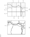
- the used map data will be described with reference to FIG. 3.
- FIG. 3 is a conceptual diagram for explaining the relationship among the travel route, the map data, and the update history.
- the controller 13 calculates the travel route R on the map represented by the map data.
- the controller 13 specifies the map data including the travel route R as the used map data.
- the used map data are the data of areas C, F, I, and J to L among the data of areas divided into A to L.
- the area of the used map data is an area along the travel route.
- the controller 13 specifies the map data to be used in units of areas including the travel route.
- step S8 the controller 13 transmits the information on the determined travel route transmitted from the communication terminal 20 in step S6 and the request for the update information on the used map data specified in step S7 to the vehicle 30.
- the information of the determined travel route is, for example, information including a departure place, a destination, and a driving route.
- the request for the update information on the used map data includes, for example, information for requesting the vehicle 30 to transmit the update history of the used map data for the vehicle from the vehicle 30 to the server 10.
- the used map data for the vehicle is map data used for the vehicle 30 traveling along the travel route, among the map data stored in the memory 33.
- the request for update information about the used map data also includes area information of the used map data.
- the update history is expressed by the version of the used map data or the update date and time.
- the area information includes the position of the area on the map by an area number or an area code.
- the vehicle-side controller 31 specifies the update history stored in correspondence with the area information in response to the request of the update information related to the used map data received from the server 10. Specifically, the vehicle-side controller 31 specifies an area included in the used map data among the vehicle map data in accordance with the area information of the map data included in the used map data received from the server 10. For example, the vehicle-side controller 31 compares the object number of the used map data with the area number of each area included in the vehicle map data, and specifies an area whose area number matches the area number as an area to be an update candidate.
- the vehicle-side controller 31 specifies an update history, hereinafter referred to as a vehicle update history, stored corresponding to the specified area, which is to be an update candidate, in response to the update information request regarding the used map data received from the server 10.
- the vehicle-side controller 31 transmits the identified vehicle update history to the server 10.
- the vehicle update history transmitted to the server 10 may be an update history of vehicle map data corresponding to at least an area of the used map data or may be an update history of the entire vehicle map data.
- the vehicle-side controller 31 specifies the area of the used map data in the vehicle map data in response to the request for information on the used map data transmitted from the server 10, but the embodiment is not limited thereto.
- the vehicle-side controller 31 may be configured to specify an area of the vehicle map data including the travel route based on the information of the determined travel route transmitted from the server 10.
- the areas indicated by the used map data are the same areas C, F, I, and J to L since the travel route used for specifying the used map data on the server side and the travel route used for specifying the used map data on the vehicle side are the same route.
- the update history transmitted from the vehicle 30 to the server 10 is history information stored in correspondence with the areas C, F, I, and J to L.
- the size of the area on the vehicle map data is the same as the size of the area of the server map data for easy explanation, but the area may be different between the vehicle map data and the server map data.
- step S10 the controller 13 of the server 10 compares the vehicle update history transmitted from the vehicle 30 with the update history, hereinafter also referred to as the server update history of the used map data specified from the server map data. For example, the controller 13 compares the update history for each corresponding area. Specifically, the controller 13 compares the vehicle update history with the server update history and determines whether the vehicle update history is older than the server update history. The controller 13 may determine whether the vehicle update history is old based on the update date and time included in each update history or the version number of the map. For example, the controller 13 determines that the vehicle update history is older than the server update history when the version number of the vehicle map data included in the vehicle update history is Version 1.0 and version number of the server map data included in the server update history is Version 2.0.
- the controller 13 determines that the vehicle update history is older than the server update history when the update date and time of the vehicle map data included in the vehicle update history is May 1 2018 and the update date and time of the server map data included in the server update history is August 1, 2018.
- step S11 the controller 13 determines whether the used map data for the vehicle needs to be updated based on the comparison result by the control process in step S10.
- the used map data for the vehicle is the data used for the vehicle to travel along the travel route.
- the map data used for the vehicle is the map data used for travel along the travel route out of the map data stored in the memory 33.
- step S10 the controller 13 compares the update history for each corresponding area and determines that the used map data needs to be updated when the vehicle update history has the older data of the area than the server update history.
- the controller 13 determines that the update is unnecessary when the controller determines that the vehicle update history is not older than the server update history in all the areas in the used map data of the vehicle map data.
- the controller 13 may determine to need the update when the area of the predetermined number or more of the areas in the used map data on the vehicle side is not the latest version.
- the control flowchart of the system ends when the controller has determined that the update is unnecessary.
- step 12 the controller 13 transmits an inquiry signal to inquire of the user whether to permit the update of the vehicle map data to the communication terminal 20 when the controller 12 determines to need the update.
- the controller 13 transmits communication environment information indicating a network state between the server 10 and the vehicle 30 when transmitting the inquiry signal.
- the server 10 transmit the update map data to the vehicle 30 to update the map data of the vehicle.
- any bad communication environment may take time for the server 10 to transmit data or fail to transmit accurate map data.
- an attempt to transmit a large amount of map data may incur a cost burden on the user under the network environment requiring billing.
- the system of the present embodiment inquires of the user whether to permit the update of the map data before the updating of the map data on the vehicle side. Further, the system provides the communication environment information indicating the network state of the vehicle 30 to the user for the user determining whether to permit the update.
- the communication environment information indicates, for example, a communication method used or available by the vehicle 30 for communication with the server 10 including the communication standard of the portable telephone communication network such as wireless LAN (Wi-Fi) and 3G, 4G, 5G.
- the vehicle 30 transmits information on the communication method of the present communication: "4G” and the available communication "wireless LAN (local area network)" to the server 10 if the vehicle 30 identifies that the on-vehicle communicator 32 communicates with the server 10 using 4G and detects that a wireless LAN network is available.
- the controller 13 Before transmitting the inquiry signal to the communication terminal 20, the controller 13 acquires the information on the above-mentioned communication system from the vehicle 30, and transmits the communication environment information indicating the network state of the vehicle generated based on the information on the communication system to the communication terminal 20 together with the inquiry signal.
- the inquiry signal is, for example, a message signal "Is it OK to update the vehicle map data used for travel the specified travel route? "Yes?" or "No?"”
- the communication environment information transmitted together is, for example, "The vehicle is currently communicating on 4G. Wireless LAN is available as another communication method. Switch the vehicle communication method to wireless LAN? “Yes” or "No?" message information.
- the controller 13 may determine the communication environment by measuring the communication speed in the control processing of steps S8 to S10. Further, the controller 13 may acquire information of the current position of the vehicle from the vehicle 30 and may identify the communication environment based on such current position. The controller 13 may transmit the specified communication environment to the communication terminal 20.
- the network may be, for example, a local network, which can communicate within a limited area of several meters to several tens of meters, formed between the user's home and the vehicle.
- step S13 the communication terminal 20 receives the inquiry signal and the communication environment information indicating the network state of the vehicle 30, and displays a display for allowing the user to determine whether to permit the update of the map data and the communication terminal communication environment information.
- the communication terminal 20 based on the message information contained in the inquiry signal and the communication environment information, causes the same screen to display the message " The vehicle map data to be used for travel the specified travel route is not latest. OK to update?" "A: Yes” or “B: No” and the message "The vehicle is currently communicating on 4G. Wireless LAN is available as another communication method. Switch the network and update the vehicle map data?" "C: Yes”.
- the messages shown in A to C can be determined by the user selecting any one by the operation of the communication terminal 20.
- the user checks the display screen and selects whether to permit update. For example, in the above-described message, when the user selects A "Yes” in step S14, the communication terminal 20 transmits an update permission signal to the server 10. On the other hand, when the user selects B "No", the controller 13 determines rejection to update and the control flowchart of the system ends.
- the communication terminal 20 transmits an update permission signal indicating the user permitting update and a communication method switching signal indicating switching the communication method to a predetermined method, here, wireless LAN, to the server 10.
- the communication terminal 20 may, on good communication environment, allow the user to select the high-precision map at the time of selecting whether to permit the update of the map data.
- step S15 the controller 13 of the server 10 outputs an update instruction signal for instructing the update of the map data and a communication system switching instruction signal to switch the communication method to a predetermined method to the vehicle 30. Further, the controller 13 includes the update map data in the update instruction signal and outputs the update map data to the on-vehicle communicator 32.
- the updated map data may include not only the data of the area whose update history is old and subject to update, but also the map data of the area around the area to be updated. This allows to update the map data of the area surrounding the area including the travel route, thus, to use the latest map data without updating the map data during the vehicle travel when changing the travel route, for example, by bypassing the congested area.
- step S16 the vehicle-side controller 31 receives the update instruction signal using the on-vehicle communicator 32 and updates the map data by rewriting the use map data of the vehicle to the update map data. Further, the controller 31 switches the communication method of the on-vehicle communicator 32 according to the switching instruction signal when receiving the signal. Then, the control flowchart of the system ends.
- the controller 13 of the server 10 acquires the travel plan data relating to the travel plan of the vehicle 30 from the communication terminal 20 via the server communicator 12, and determines whether the map data, which is used for the travel in accordance with the travel plan from the data stored in the memory 31 of the vehicle 30, need to be updated,
- the controller 13 transmits an inquiry signal to inquire of the user whether to permit updating of the map data to the communication terminal 20 via the server communicator 12 when the controller 13 has determined that the map data needs to be updated.
- the controller 13 transmits an update instruction signal including instruction data for instructing the update of the map data via the server communicator 12 to the on-vehicle communicator 32 when receiving a permission signal to update the map data via the server communicator 12.
- the vehicle 30 can prevent from interrupting to use the navigation system due to the updating of the map data because the update of the map data before the user riding eliminates the time for updating the map data to the latest version after the ride of the vehicle 30.
- the controller 13 determines whether the update is necessary based on the update history of the map data. This allows to determine whether the information on the update history of the map data is the latest.
- the controller 13 transmits a signal indicating whether the vehicle 30 is connected to a predetermined communication network to the communication terminal 20 via the server communicator 12. This allows the user operating the communication terminal 20 to grasp the communication environment used when updating the map data.
- the controller 13 determines whether the update is necessary based on the update history of the map data used for the travel along the travel route from the departure point to the destination in the memory 33. This allows to reduce the amount of data to be updated.
Landscapes
- Engineering & Computer Science (AREA)
- Radar, Positioning & Navigation (AREA)
- Remote Sensing (AREA)
- Physics & Mathematics (AREA)
- General Physics & Mathematics (AREA)
- Automation & Control Theory (AREA)
- Computer Networks & Wireless Communication (AREA)
- Signal Processing (AREA)
- Databases & Information Systems (AREA)
- Navigation (AREA)
- Traffic Control Systems (AREA)
Applications Claiming Priority (1)
| Application Number | Priority Date | Filing Date | Title |
|---|---|---|---|
| PCT/IB2018/001203 WO2020070532A1 (ja) | 2018-10-01 | 2018-10-01 | 情報処理システム、情報処理装置、及び情報処理方法 |
Publications (3)
| Publication Number | Publication Date |
|---|---|
| EP3862995A1 true EP3862995A1 (de) | 2021-08-11 |
| EP3862995A4 EP3862995A4 (de) | 2021-10-20 |
| EP3862995B1 EP3862995B1 (de) | 2026-04-15 |
Family
ID=70054710
Family Applications (1)
| Application Number | Title | Priority Date | Filing Date |
|---|---|---|---|
| EP18936264.3A Active EP3862995B1 (de) | 2018-10-01 | 2018-10-01 | Informationsverarbeitungssysteme und informationsverarbeitungsverfahren |
Country Status (5)
| Country | Link |
|---|---|
| US (2) | US11747168B2 (de) |
| EP (1) | EP3862995B1 (de) |
| JP (1) | JP7062785B2 (de) |
| CN (1) | CN112789671B (de) |
| WO (1) | WO2020070532A1 (de) |
Families Citing this family (9)
| Publication number | Priority date | Publication date | Assignee | Title |
|---|---|---|---|---|
| CN117073704A (zh) * | 2020-03-30 | 2023-11-17 | 御眼视觉技术有限公司 | 使用电子地平线导航交通工具 |
| JP7132368B2 (ja) * | 2021-01-12 | 2022-09-06 | 本田技研工業株式会社 | 車両システム |
| JP7164639B2 (ja) * | 2021-01-12 | 2022-11-01 | 本田技研工業株式会社 | 車両システム |
| JP7164640B2 (ja) * | 2021-01-12 | 2022-11-01 | 本田技研工業株式会社 | 車両システム |
| JP7307755B2 (ja) * | 2021-01-14 | 2023-07-12 | 本田技研工業株式会社 | 制御システム、移動体、サーバ、制御方法、及びプログラム |
| JP7753122B2 (ja) * | 2022-02-01 | 2025-10-14 | 矢崎エナジーシステム株式会社 | 管理システム、及びプログラム |
| US11543264B1 (en) * | 2022-02-23 | 2023-01-03 | Plusai, Inc. | Methods and apparatus for navigating an autonomous vehicle based on a map updated in regions |
| US12229712B1 (en) * | 2022-05-18 | 2025-02-18 | Amazon Technologies, Inc. | Systems and methods for road network aware geographical unit generation |
| WO2024262017A1 (ja) * | 2023-06-23 | 2024-12-26 | 三菱電機モビリティ株式会社 | 地図更新装置および地図更新方法 |
Family Cites Families (22)
| Publication number | Priority date | Publication date | Assignee | Title |
|---|---|---|---|---|
| JP3864734B2 (ja) * | 2001-08-30 | 2007-01-10 | 日産自動車株式会社 | 車載用ナビゲーション装置、ナビゲーション情報提供装置、および通信型ナビゲーションシステムのサービス提供方法 |
| WO2004008073A1 (ja) * | 2002-07-17 | 2004-01-22 | Xanavi Informatics Corporation | ナビゲーション方法、ナビゲーションシステムのための処理方法、地図データ管理装置、地図データ管理プログラム、及びコンピュータプログラム |
| JP4415825B2 (ja) * | 2004-10-28 | 2010-02-17 | 株式会社デンソー | 地図データ更新方法、地図データ更新システム、地図情報サーバ及び車載装置 |
| JP4415949B2 (ja) * | 2006-01-25 | 2010-02-17 | 株式会社日立製作所 | 走行制御システム及び走行制御方法 |
| JP5298417B2 (ja) * | 2006-10-03 | 2013-09-25 | 株式会社デンソー | 地図データ利用装置、ナビゲーション装置 |
| JP4725535B2 (ja) * | 2007-02-27 | 2011-07-13 | アイシン・エィ・ダブリュ株式会社 | 地図情報更新システム |
| JP4715827B2 (ja) * | 2007-10-11 | 2011-07-06 | 株式会社デンソー | 地図データ更新システム |
| JP5011074B2 (ja) * | 2007-11-22 | 2012-08-29 | 日立オートモティブシステムズ株式会社 | 地図データ更新方法、地図データ更新プログラムおよびカーナビゲーション装置 |
| JP5111175B2 (ja) * | 2008-03-13 | 2012-12-26 | 公益財団法人鉄道総合技術研究所 | 案内システム、携帯型電子機器及び制御プログラム |
| CN101556165A (zh) * | 2009-04-24 | 2009-10-14 | 方舟信息技术(苏州)有限公司 | 嵌入式移动电子地图数据库的实时更新方法 |
| US8849552B2 (en) * | 2010-09-29 | 2014-09-30 | Ford Global Technologies, Llc | Advanced map information delivery, processing and updating |
| IN2014DN08343A (de) * | 2012-03-16 | 2015-05-08 | Qoros Automotive Co Ltd | |
| CN103618826B (zh) * | 2013-11-25 | 2015-04-22 | 深圳市航盛电子股份有限公司 | 一种手机应用通过3g通道启动车载导航的方法 |
| KR101548953B1 (ko) * | 2013-12-24 | 2015-09-01 | 현대자동차주식회사 | 차량용 정보 갱신 방법 및 장치 |
| JP6553874B2 (ja) * | 2015-01-13 | 2019-07-31 | 株式会社 ミックウェア | 地図情報システム |
| US9880735B2 (en) * | 2015-08-10 | 2018-01-30 | Apple Inc. | Devices, methods, and graphical user interfaces for manipulating user interface objects with visual and/or haptic feedback |
| JP6798779B2 (ja) * | 2015-11-04 | 2020-12-09 | トヨタ自動車株式会社 | 地図更新判定システム |
| US11087291B2 (en) | 2015-11-24 | 2021-08-10 | Honda Motor Co., Ltd.. | Action planning and execution support device |
| JP2017096769A (ja) * | 2015-11-24 | 2017-06-01 | 本田技研工業株式会社 | 行動計画立案・実行支援装置 |
| JP6819076B2 (ja) * | 2016-05-17 | 2021-01-27 | 株式会社デンソー | 走行計画作成装置及びセンタ |
| JP6813347B2 (ja) * | 2016-12-12 | 2021-01-13 | アイシン・エィ・ダブリュ株式会社 | 通信端末、移動案内システム及びコンピュータプログラム |
| CN107677269B (zh) * | 2017-08-28 | 2018-08-14 | 广东工业大学 | 一种基于拓扑地图的弱信号区域智能导航方法 |
-
2018
- 2018-10-01 EP EP18936264.3A patent/EP3862995B1/de active Active
- 2018-10-01 US US17/282,165 patent/US11747168B2/en active Active
- 2018-10-01 WO PCT/IB2018/001203 patent/WO2020070532A1/ja not_active Ceased
- 2018-10-01 JP JP2020550927A patent/JP7062785B2/ja active Active
- 2018-10-01 CN CN201880098259.0A patent/CN112789671B/zh active Active
-
2023
- 2023-07-21 US US18/356,697 patent/US12025466B2/en active Active
Also Published As
| Publication number | Publication date |
|---|---|
| US20240019266A1 (en) | 2024-01-18 |
| US12025466B2 (en) | 2024-07-02 |
| US20220146278A1 (en) | 2022-05-12 |
| CN112789671A (zh) | 2021-05-11 |
| EP3862995A4 (de) | 2021-10-20 |
| JP7062785B2 (ja) | 2022-05-06 |
| EP3862995B1 (de) | 2026-04-15 |
| WO2020070532A1 (ja) | 2020-04-09 |
| JPWO2020070532A1 (ja) | 2021-09-24 |
| US11747168B2 (en) | 2023-09-05 |
| CN112789671B (zh) | 2022-10-28 |
Similar Documents
| Publication | Publication Date | Title |
|---|---|---|
| US12025466B2 (en) | Information processing systems, information processing apparatus, and information processing methods | |
| JP6959959B2 (ja) | ソフトウェア更新装置、サーバ装置、およびソフトウェア更新方法 | |
| CN115080672A (zh) | 一种地图更新方法、基于地图的驾驶决策方法及装置 | |
| CN103033191B (zh) | 地图数据分配设备、电子设备和地图更新系统 | |
| CN108062863A (zh) | 一种快速车道的规划方法及单元 | |
| JP2010210284A (ja) | 交通管理装置および交通管理方法 | |
| CN102027321A (zh) | 导航装置及方法 | |
| EP1582841B1 (de) | Server, system und verfahren zur routensuche | |
| JP2011214930A (ja) | 充電待ち時間情報提供装置およびカーナビゲーション装置 | |
| CN113748446A (zh) | 用于比较机动车辆行程的技术 | |
| US11105647B2 (en) | Information analysis device and path information analysis method | |
| CN103177562A (zh) | 一种获取交通状态预测所需信息的方法及装置 | |
| JP2012002667A (ja) | 情報提供装置および情報提供方法 | |
| CN101111741B (zh) | 导航设备及交通信息传输方法 | |
| JP2019074986A (ja) | 動態管理サーバ、動態管理方法および動態管理プログラム | |
| WO2019193852A1 (ja) | 情報分析装置及び情報分析方法 | |
| JP2007114857A (ja) | 交通情報処理装置 | |
| JP4075649B2 (ja) | 車両用情報通信装置 | |
| US11348457B2 (en) | Analysis device and analysis method | |
| JP6962659B2 (ja) | 電子装置 | |
| JP7218464B2 (ja) | 情報処理システム、情報処理装置、及び情報処理方法 | |
| JP7574452B2 (ja) | 駐車場情報分析装置及び駐車場情報分析方法 | |
| WO2022259862A1 (ja) | 車載装置、制御装置、システム、車載装置の制御方法及びコンピュータプログラム | |
| JP7099383B2 (ja) | 経路設定装置、経路設定方法、及びプログラム | |
| JP2005165809A (ja) | 経路探索装置、および経路探索方法 |
Legal Events
| Date | Code | Title | Description |
|---|---|---|---|
| STAA | Information on the status of an ep patent application or granted ep patent |
Free format text: STATUS: THE INTERNATIONAL PUBLICATION HAS BEEN MADE |
|
| PUAI | Public reference made under article 153(3) epc to a published international application that has entered the european phase |
Free format text: ORIGINAL CODE: 0009012 |
|
| STAA | Information on the status of an ep patent application or granted ep patent |
Free format text: STATUS: REQUEST FOR EXAMINATION WAS MADE |
|
| 17P | Request for examination filed |
Effective date: 20210423 |
|
| AK | Designated contracting states |
Kind code of ref document: A1 Designated state(s): AL AT BE BG CH CY CZ DE DK EE ES FI FR GB GR HR HU IE IS IT LI LT LU LV MC MK MT NL NO PL PT RO RS SE SI SK SM TR |
|
| REG | Reference to a national code |
Ref country code: DE Ref legal event code: R079 Free format text: PREVIOUS MAIN CLASS: G08G0001130000 Ipc: G01C0021000000 |
|
| A4 | Supplementary search report drawn up and despatched |
Effective date: 20210917 |
|
| RIC1 | Information provided on ipc code assigned before grant |
Ipc: G08G 1/13 20060101ALI20210914BHEP Ipc: G01C 21/32 20060101ALI20210914BHEP Ipc: G01C 21/00 20060101AFI20210914BHEP |
|
| DAV | Request for validation of the european patent (deleted) | ||
| DAX | Request for extension of the european patent (deleted) | ||
| RAP3 | Party data changed (applicant data changed or rights of an application transferred) |
Owner name: RENAULT S.A.S Owner name: NISSAN MOTOR CO., LTD. |
|
| RAP3 | Party data changed (applicant data changed or rights of an application transferred) |
Owner name: RENAULT S.A.S Owner name: NISSAN MOTOR CO., LTD. |
|
| STAA | Information on the status of an ep patent application or granted ep patent |
Free format text: STATUS: EXAMINATION IS IN PROGRESS |
|
| 17Q | First examination report despatched |
Effective date: 20231006 |
|
| GRAP | Despatch of communication of intention to grant a patent |
Free format text: ORIGINAL CODE: EPIDOSNIGR1 |
|
| STAA | Information on the status of an ep patent application or granted ep patent |
Free format text: STATUS: GRANT OF PATENT IS INTENDED |
|
| INTG | Intention to grant announced |
Effective date: 20260119 |
|
| GRAS | Grant fee paid |
Free format text: ORIGINAL CODE: EPIDOSNIGR3 |
|
| GRAA | (expected) grant |
Free format text: ORIGINAL CODE: 0009210 |
|
| STAA | Information on the status of an ep patent application or granted ep patent |
Free format text: STATUS: THE PATENT HAS BEEN GRANTED |
|
| AK | Designated contracting states |
Kind code of ref document: B1 Designated state(s): AL AT BE BG CH CY CZ DE DK EE ES FI FR GB GR HR HU IE IS IT LI LT LU LV MC MK MT NL NO PL PT RO RS SE SI SK SM TR |
|
| REG | Reference to a national code |
Ref country code: CH Ref legal event code: F10 Free format text: ST27 STATUS EVENT CODE: U-0-0-F10-F00 (AS PROVIDED BY THE NATIONAL OFFICE) Effective date: 20260415 Ref country code: GB Ref legal event code: FG4D |
|
| REG | Reference to a national code |
Ref country code: DE Ref legal event code: R096 Ref document number: 602018090685 Country of ref document: DE |