EP3901579A1 - Procédé d'aide à la navigation, dispositif d'aide à la navigation et programme d'aide à la navigation - Google Patents
Procédé d'aide à la navigation, dispositif d'aide à la navigation et programme d'aide à la navigation Download PDFInfo
- Publication number
- EP3901579A1 EP3901579A1 EP18943921.9A EP18943921A EP3901579A1 EP 3901579 A1 EP3901579 A1 EP 3901579A1 EP 18943921 A EP18943921 A EP 18943921A EP 3901579 A1 EP3901579 A1 EP 3901579A1
- Authority
- EP
- European Patent Office
- Prior art keywords
- vessel
- pattern
- speed
- data
- performance estimation
- Prior art date
- Legal status (The legal status is an assumption and is not a legal conclusion. Google has not performed a legal analysis and makes no representation as to the accuracy of the status listed.)
- Granted
Links
Images




Classifications
-
- G—PHYSICS
- G01—MEASURING; TESTING
- G01C—MEASURING DISTANCES, LEVELS OR BEARINGS; SURVEYING; NAVIGATION; GYROSCOPIC INSTRUMENTS; PHOTOGRAMMETRY OR VIDEOGRAMMETRY
- G01C21/00—Navigation; Navigational instruments not provided for in groups G01C1/00 - G01C19/00
- G01C21/10—Navigation; Navigational instruments not provided for in groups G01C1/00 - G01C19/00 by using measurements of speed or acceleration
- G01C21/12—Navigation; Navigational instruments not provided for in groups G01C1/00 - G01C19/00 by using measurements of speed or acceleration executed aboard the object being navigated; Dead reckoning
- G01C21/14—Navigation; Navigational instruments not provided for in groups G01C1/00 - G01C19/00 by using measurements of speed or acceleration executed aboard the object being navigated; Dead reckoning by recording the course traversed by the object
-
- G—PHYSICS
- G01—MEASURING; TESTING
- G01C—MEASURING DISTANCES, LEVELS OR BEARINGS; SURVEYING; NAVIGATION; GYROSCOPIC INSTRUMENTS; PHOTOGRAMMETRY OR VIDEOGRAMMETRY
- G01C21/00—Navigation; Navigational instruments not provided for in groups G01C1/00 - G01C19/00
- G01C21/20—Instruments for performing navigational calculations
- G01C21/203—Instruments for performing navigational calculations specially adapted for water-borne vessels
-
- B—PERFORMING OPERATIONS; TRANSPORTING
- B63—SHIPS OR OTHER WATERBORNE VESSELS; RELATED EQUIPMENT
- B63H—MARINE PROPULSION OR STEERING
- B63H25/00—Steering; Slowing-down otherwise than by use of propulsive elements; Dynamic anchoring, i.e. positioning vessels by means of main or auxiliary propulsive elements
- B63H25/02—Initiating means for steering, for slowing down, otherwise than by use of propulsive elements, or for dynamic anchoring
- B63H25/04—Initiating means for steering, for slowing down, otherwise than by use of propulsive elements, or for dynamic anchoring automatic, e.g. reacting to compass
-
- G—PHYSICS
- G01—MEASURING; TESTING
- G01C—MEASURING DISTANCES, LEVELS OR BEARINGS; SURVEYING; NAVIGATION; GYROSCOPIC INSTRUMENTS; PHOTOGRAMMETRY OR VIDEOGRAMMETRY
- G01C21/00—Navigation; Navigational instruments not provided for in groups G01C1/00 - G01C19/00
- G01C21/38—Electronic maps specially adapted for navigation; Updating thereof
- G01C21/3804—Creation or updating of map data
- G01C21/3807—Creation or updating of map data characterised by the type of data
- G01C21/3826—Terrain data
-
- G—PHYSICS
- G01—MEASURING; TESTING
- G01C—MEASURING DISTANCES, LEVELS OR BEARINGS; SURVEYING; NAVIGATION; GYROSCOPIC INSTRUMENTS; PHOTOGRAMMETRY OR VIDEOGRAMMETRY
- G01C21/00—Navigation; Navigational instruments not provided for in groups G01C1/00 - G01C19/00
- G01C21/38—Electronic maps specially adapted for navigation; Updating thereof
- G01C21/3804—Creation or updating of map data
- G01C21/3833—Creation or updating of map data characterised by the source of data
- G01C21/3837—Data obtained from a single source
-
- G—PHYSICS
- G01—MEASURING; TESTING
- G01C—MEASURING DISTANCES, LEVELS OR BEARINGS; SURVEYING; NAVIGATION; GYROSCOPIC INSTRUMENTS; PHOTOGRAMMETRY OR VIDEOGRAMMETRY
- G01C21/00—Navigation; Navigational instruments not provided for in groups G01C1/00 - G01C19/00
- G01C21/38—Electronic maps specially adapted for navigation; Updating thereof
- G01C21/3885—Transmission of map data to client devices; Reception of map data by client devices
- G01C21/3889—Transmission of selected map data, e.g. depending on route
-
- G—PHYSICS
- G08—SIGNALLING
- G08G—TRAFFIC CONTROL SYSTEMS
- G08G3/00—Traffic control systems for marine craft
-
- Y—GENERAL TAGGING OF NEW TECHNOLOGICAL DEVELOPMENTS; GENERAL TAGGING OF CROSS-SECTIONAL TECHNOLOGIES SPANNING OVER SEVERAL SECTIONS OF THE IPC; TECHNICAL SUBJECTS COVERED BY FORMER USPC CROSS-REFERENCE ART COLLECTIONS [XRACs] AND DIGESTS
- Y02—TECHNOLOGIES OR APPLICATIONS FOR MITIGATION OR ADAPTATION AGAINST CLIMATE CHANGE
- Y02T—CLIMATE CHANGE MITIGATION TECHNOLOGIES RELATED TO TRANSPORTATION
- Y02T70/00—Maritime or waterways transport
Definitions
- the present invention relates to a navigation support method and the like.
- a navigation support system in which the performance of a vessel is estimated based on vessel voyage data and past meteorological and hydrographic data, and an optimal route for this vessel is computed based on the estimated performance of the vessel and meteorological and hydrographic data (see, for example, Patent Documents 1 and 2).
- the system estimates the performance of the vessel (the vessel navigation speed and the fuel consumption amount) under predicted meteorological and hydrographic conditions, and searches for an optimal route that enables the arrival with less fuel consumption amount.
- the captain of a vessel selects a route with low wind and wave resistance at a normal output prescribed at the time of designing the vessel.
- the normal output mentioned here is an output that is normally used to obtain navigation velocity, and refers to an economical output from the viewpoint of engine efficiency and maintenance.
- a route selected at the normal output is a route that suits the captain's sense, and is deemed as a route that requires less fuel expense and takes less time.
- a conventional navigation support system has a disadvantage that it is not possible to present an accurate optimal route at the normal output.
- the conventional navigation support system searches for an optimal route by presuming a constant engine speed.
- the conventional navigation support system can calculate the arrival time when passing through the optimal route found by the search.
- it is difficult to keep the engine speed constant due to the influence of waves, wind, and ocean currents. It is known that keeping the engine speed constant will impose a load on the engine and lead to failure. Therefore, it can be said that the optimal route and arrival time found by the search in the conventional navigation support system do not match the reality. Accordingly, the conventional navigation support system cannot present an accurate optimal route at the normal output.
- the above-mentioned problem is a problem that arises not only in the normal output but also in other vessel maneuvering patterns similarly, such as a medium output that does not impose a load on the engine and a small output for reducing the fuel expense.
- an object of the present invention is to present an accurate optimal route according to a vessel maneuvering pattern.
- a computer executes processing including: storing performance estimation models regarding speed of a vessel for each of vessel maneuvering patterns; accepting one of the vessel maneuvering patterns to be used in a navigation; calculating the speed of the vessel on a route of the vessel, based on one of the performance estimation models that corresponds to the accepted one of the vessel maneuvering patterns among the performance estimation models, and meteorological and hydrographic forecast data; and displaying an arrival time on the route that is optimal, based on the speed of the vessel that has been calculated.
- an accurate optimal route according to a vessel maneuvering pattern can be presented.
- FIG. 1 is a functional block diagram illustrating a configuration of a navigation support device according to an embodiment.
- the navigation support device 1 classifies vessel navigation data according to each meteorological and hydrographic condition, and calculates the distribution of vessel speed for each meteorological and hydrographic condition used for the classification.
- the navigation support device 1 aggregates the vessel voyage data for each vessel maneuvering pattern extracted from vessel maneuvering distribution calculated for each meteorological and hydrographic condition used for the classification.
- the navigation support device 1 learns the vessel performance using the aggregated vessel voyage data and past meteorological and hydrographic data for each vessel maneuvering pattern, and constructs an estimation model for the vessel performance for each vessel maneuvering pattern.
- the navigation support device 1 calculates the speed of the vessel in the entire section from the start to the goal, based on the estimation model corresponding to the accepted vessel maneuvering pattern among the estimation models for the vessel performance.
- the navigation support device 1 displays the arrival time on the route that is optimal, based on the calculated speed of the vessel.
- the vessel performance mentioned here includes the navigation speed, fuel consumption amount, and the like of the vessel.
- the vessel maneuvering pattern mentioned here refers to a pattern that the captain actually selects when maneuvering the vessel.
- the vessel maneuvering pattern for example, "pattern a" in which the vessel is maneuvered at a normal output, “pattern b” in which the vessel is maneuvered with the engine output slightly lowered, “pattern c” in which the vessel is maneuvered on a voyage in deceleration, and the like are assumed.
- pattern a in which the vessel is maneuvered at a normal output
- pattern b in which the vessel is maneuvered with the engine output slightly lowered
- pattern c in which the vessel is maneuvered on a voyage in deceleration
- “Pattern a” is a pattern in which a vessel is maneuvered by selecting a route with low wind and wave resistance at a normal output prescribed at the time of designing the vessel.
- Normal output refers to an economical output from the viewpoint of engine efficiency and maintenance. A route selected at the normal output is deemed as a route that requires less fuel expense and takes less time.
- the pattern a is referred to as a vessel maneuvering pattern at the normal output.
- “Pattern b” is a pattern in which a vessel is maneuvered by lowering the output so as not to impose a load on the engine (not to cause a torque-rich phenomenon) under stormy weather.
- the pattern b is referred to as a vessel maneuvering pattern at a medium output.
- “Pattern c” is a pattern in which a vessel is decelerated and maneuvered in order to reduce fuel expense when there is no next navigation schedule and there is time to spare.
- the pattern c is referred to as a vessel maneuvering pattern at a small output. Note that the vessel maneuvering patterns are not limited to these patterns.
- the vessel maneuvering patterns may include a pattern d in which a vessel is maneuvered by increasing the output so as to impose a load on the engine when there is no time to spare.
- the pattern d is referred to as a vessel maneuvering pattern at a high output.
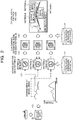
- FIG. 2 is a diagram illustrating an outline of navigation support according to the embodiment.
- the navigation support device 1 calculates the distribution of vessel speed from voyage data 21 relating to the vessel, and extracts a vessel maneuvering pattern (pattern) from the distribution of vessel speed ( ⁇ 1>).
- the distribution of vessel speed indicates the frequency distribution of vessel speed.
- the pattern is extracted based on the frequency of occurrence.
- a section with the highest frequency of occurrence is extracted as the pattern a at the normal output. This is because the captain often selects a route with low wind and wave resistance to navigate at the normal output prescribed at the time of designing the vessel.
- a section with the next highest frequency of occurrence is extracted as the pattern b at the medium output.
- a section with the slowest vessel speed is extracted as the pattern c at the small output.
- the distribution may be derived from engine speed or horsepower instead of vessel speed.
- the navigation support device 1 obtains voyage data 21' by aggregation for each pattern ( ⁇ 2>).
- the navigation support device 1 learns the vessel performance using the voyage data 21' aggregated for each pattern and actual meteorological/hydrographic data (actual/forecast) 22, and constructs an estimation model for the vessel performance for each pattern ( ⁇ 3>).
- the navigation support device 1 estimates the vessel performance from the start to the goal of the vessel for each pattern, on the basis of forecast meteorological/hydrographic data (actual/forecast) 22 and the estimation model for the vessel performance for each pattern.
- the vessel performance mentioned here indicates the navigation speed, fuel consumption amount, and the like of the vessel.
- the navigation support device 1 calculates an optimal route for the vessel based on the estimated vessel performance for each pattern, and displays the arrival time on the optimal route, for example, to the vessel as a source of acceptance ( ⁇ 4>).
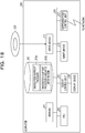
- the navigation support device 1 includes a control unit 10 and a storage unit 20.
- the control unit 10 corresponds to an electronic circuit such as a central processing unit (CPU). Then, the control unit 10 includes an internal memory for storing programs defining various processing procedures and control data, and executes a variety of types of processing using the programs and the control data.
- the control unit 10 includes a data collection unit 11, a voyage data classification unit 12, a pattern extraction unit 13, a voyage data aggregation unit 14, and a performance estimation model generation unit 15. Furthermore, the control unit 10 includes a performance estimation unit 16 and an optimal route search unit 17.
- the voyage data classification unit 12, the pattern extraction unit 13, the voyage data aggregation unit 14, and the performance estimation model generation unit 15 are functional units for a model learning phase.
- the performance estimation unit 16 and the optimal route search unit 17 are functional units for a service provision phase.
- the performance estimation unit 16 and the optimal route search unit 17 are an example of a calculation unit.
- the optimal route search unit 17 is an example of a display unit.
- the storage unit 20 is a semiconductor memory element such as a random access memory (RAM) or a flash memory, or a storage device such as a hard disk or an optical disc.
- the storage unit 20 has the voyage data 21, the meteorological/hydrographic data (actual/forecast) 22, voyage data (for each meteorological and hydrographic condition) 23, a pattern 24, voyage data (for each pattern) 25, and a performance estimation model 26.
- the performance estimation model 26 is an example of a storage unit.
- the voyage data 21 is data indicating, for example, when, where, at what speed, and in which direction the vessel was heading during voyage. In different terms, the voyage data 21 is data indicating the history of vessel maneuvering performed by the captain of the vessel.
- the voyage data 21 is collected using, for example, an automatic identification system (AIS), a voyage data recorder (VDR), and an engine logger.
- AIS automatic identification system
- VDR voyage data recorder
- FIG. 3 is a diagram illustrating an example of the voyage data according to the embodiment.
- the voyage data 21 stores the latitude, longitude, speed, traveling direction, ..., bow direction, time, ..., for each versel_name in association with each other.
- the item versel_name indicates the name of the vessel.
- the voyage data 21 is not limited to this example, and the engine speed and consumed fuel may be further added.
- the meteorological/hydrographic data (actual/forecast) 22 includes meteorological data and hydrographic data including the actual results and forecasts for the vessel.
- the meteorological/hydrographic data (actual/forecast) 22 can be collected using, for example, data delivered from a weather forecast data provider.
- FIG. 4 is a diagram illustrating an example of meteorological/hydrographic data according to the embodiment.
- the upper figure in FIG. 4 represents forecast wind data in the meteorological data.
- the middle figure in FIG. 4 represents forecast wave data in the hydrographic data.
- the lower figure in FIG. 4 represents forecast ocean current data in the hydrographic data.
- the wind data stores the latitude, longitude, wind speed, and wind direction in association with the forecast delivery date and time and the target date and time.
- the wave data stores the latitude, longitude, wave height, wave direction, and wave period in association with the forecast delivery date and time and the target date and time.
- the ocean current data stores the latitude, longitude, ocean current speed, ocean current direction, and layer in association with the forecast delivery date and time and the target date and time.
- the voyage data (for each meteorological and hydrographic condition) 23 is voyage data obtained by classifying the voyage data 21 according to each meteorological and hydrographic condition. Note that the voyage data (for each meteorological and hydrographic condition) 23 is classified by the voyage data classification unit 12.
- the pattern 24 is a vessel maneuvering pattern extracted from a plurality of vessel maneuvering patterns. Note that the pattern 24 is extracted by the pattern extraction unit 12.
- the voyage data (for each pattern) 25 is voyage data obtained by aggregating the voyage data 21 for each pattern. Note that the voyage data (for each pattern) 25 is aggregated by the voyage data aggregation unit 14.
- the performance estimation model 26 is an estimation model for the vessel performance for each pattern. Note that the performance estimation model 26 is generated by the performance estimation model generation unit 15.
- the data collection unit 11 collects various types of data. For example, the data collection unit 11 collects the voyage data 21 using an AIS. The data collection unit 11 receives the meteorological data (actual/forecast) and the hydrographic data (actual/forecast) delivered from the weather forecast data provider, and collects the meteorological/hydrographic data (actual/forecast) 22.
- the voyage data classification unit 12 classifies the voyage data 21 according to each meteorological and hydrographic condition.
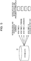
- FIG. 5 is a diagram illustrating an example of voyage data classification processing according to the embodiment.
- the voyage data classification unit 12 classifies the voyage data 21 according to each meteorological and hydrographic condition assigned in advance, and generates the voyage data 23 for each meteorological and hydrographic condition.
- the case indicated here is a case where the wind speed and the wind direction are applied as meteorological and hydrographic conditions.
- meteorological and hydrographic conditions a case where the wind force is "0", a case where the wind force is "1" and forward, a case where the wind force is "1" and backward,..., and a case where the wind force is "10" and backward on the port side are illustrated.
- the voyage data 21 is classified according to each of such meteorological and hydrographic conditions into the voyage data 23 for each meteorological and hydrographic condition.
- the pattern extraction unit 13 clusters vessel speed data of the voyage data 23 for each meteorological and hydrographic condition, and extracts the vessel maneuvering pattern (pattern). For example, the pattern extraction unit 13 clusters the vessel speed data using data including at least the position (latitude and longitude), time, and vessel speed during voyage in the voyage data 23 for each meteorological and hydrographic condition. For clustering, the k-means method or the like can be used as an example. Then, as a result of clustering, the pattern extraction unit 13 extracts, as an example, a vessel maneuvering pattern (pattern a) at the normal output, a vessel maneuvering pattern (pattern b) at the medium output, a vessel maneuvering pattern (pattern c) at the small output, and the like.
- the pattern extraction unit 13 saves the extracted patterns in the pattern 24.
- the pattern extraction unit 13 has been described to cluster the vessel speed data of the voyage data 23 for each meteorological and hydrographic condition to extract patterns, but is not limited to this example.
- the engine speed or horsepower may be used instead of the vessel speed data to perform clustering and extract patterns.
- the voyage data aggregation unit 14 calculates the distribution of vessel speed using the voyage data 23 for each meteorological and hydrographic condition.
- the distribution of vessel speed mentioned here refers to, for example, the distribution of frequency of occurrence of vessel speed.
- the voyage data aggregation unit 14 calculates the distribution of frequency of occurrence of vessel speed with respect to the voyage data 23 for each meteorological and hydrographic condition.
- the voyage data aggregation unit 14 divides the distribution into sections based on the frequency of occurrence in the distribution of vessel speed calculated for each meteorological and hydrographic condition.
- the divided sections are associated with the vessel maneuvering patterns. This allows the voyage data aggregation unit 14 to regard a section of vessel speed with the highest frequency of occurrence as the vessel maneuvering pattern at the normal output, by calculating the frequency of occurrence of vessel speed under the same meteorological and hydrographic condition. In other words, this is because it is assumed that the captain often selects the normal output, which is an economical output, when maneuvering a vessel.
- the voyage data aggregation unit 14 can regard a section of the distribution obtained from the frequency of occurrence and the vessel speed, as a predetermined vessel maneuvering pattern, by calculating the frequency of occurrence of vessel speed under the same meteorological and hydrographic condition.
- the voyage data aggregation unit 14 aggregates the voyage data 23 for each meteorological and hydrographic condition for each vessel maneuvering pattern, and generates the voyage data 25 for each vessel maneuvering pattern.
- the voyage data aggregation unit 14 may correct the voyage data 25 for each vessel maneuvering pattern when obtaining the voyage data 25 for each vessel maneuvering pattern by aggregation.
- the voyage data aggregation unit 14 designates the vessel maneuvering pattern based on the frequency of occurrence of vessel speed for the same meteorological and hydrographic condition.
- the voyage data aggregation unit 14 designates the vessel maneuvering pattern only according to the vessel speed, aggregation will result in the vessel maneuvering pattern to be switched in a very short period of time, but in reality, the vessel maneuvering pattern is not switched in a very short period of time.
- the voyage data aggregation unit 14 to correct the voyage data of the vessel maneuvering pattern by employing a most frequent vessel maneuvering pattern contained in a predetermined period of time as a vessel maneuvering pattern for that period of time.
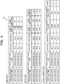
- FIG. 6 is a diagram illustrating an example of voyage data aggregation processing according to the embodiment.
- FIG. 6 describes a case where the voyage data aggregation unit 14 aggregates the voyage data 23 for each meteorological and hydrographic condition with respect to the vessel maneuvering pattern at the normal output, and generates the voyage data 25 of the vessel maneuvering pattern at the normal output.
- the voyage data aggregation unit 14 calculates a frequency distribution table of each vessel speed, using the voyage data 23 for each meteorological and hydrographic condition.
- the voyage data aggregation unit 14 divides the distribution into sections based on the frequency of occurrence in the calculated frequency distribution table of vessel speed.
- a section of vessel speed with the highest frequency of occurrence is regarded as the vessel maneuvering pattern at the normal output. This is because it is assumed that the captain often selects the normal output, which is an economical output, when maneuvering a vessel.
- the voyage data aggregation unit 14 aggregates the voyage data 23 for each meteorological and hydrographic condition, and generates the voyage data 25 of the vessel maneuvering pattern at the normal output.
- a section of vessel speed with the highest frequency of occurrence is regarded as the vessel maneuvering pattern at the normal output. Accordingly, the voyage data aggregation unit 14 aggregates the voyage data of the section of vessel speed with the highest frequency of occurrence from the respective frequency distribution tables calculated for each meteorological and hydrographic condition, and generates the voyage data 25 of the vessel maneuvering pattern at the normal output.
- a section of vessel speed with the next highest frequency of occurrence may be employed as the vessel maneuvering pattern at the medium output.
- the voyage data aggregation unit 14 aggregates the voyage data of the section of the distribution of vessel speed with the next highest frequency of occurrence from the respective frequency distribution tables calculated for each meteorological and hydrographic condition, and generates the voyage data 25 of the vessel maneuvering pattern at the medium output.
- a section of the distribution with the slowest vessel speed may be employed as the vessel maneuvering pattern at the small output.
- the voyage data aggregation unit 14 aggregates the voyage data of the section of the distribution with the slowest vessel speed from the respective frequency distribution tables calculated for each meteorological and hydrographic condition, and generates the voyage data 25 of the vessel maneuvering pattern at the small output. Furthermore, a section of the distribution with the fastest vessel speed may be employed as the vessel maneuvering pattern at the high output. In such a case, the voyage data aggregation unit 14 aggregates the voyage data of the section of the distribution with the fastest vessel speed from the respective frequency distribution tables calculated for each meteorological and hydrographic condition, and generates the voyage data 25 of the vessel maneuvering pattern at the high output.
- FIG. 7 is a diagram illustrating an example of correction processing for the voyage data for each pattern according to the embodiment.
- the voyage data aggregation unit 14 has obtained the voyage data 25 for each vessel maneuvering pattern by aggregation, such as the pattern a (normal output), the pattern b, and the pattern c.
- the voyage data for every one minute before correction is represented.
- Each piece of the voyage data switches the vessel maneuvering pattern based on the frequency of occurrence of vessel speed.
- the voyage data aggregation unit 14 designates the vessel maneuvering pattern only according to the vessel speed, the vessel maneuvering pattern will be switched in a very short period of time, but in reality, the vessel maneuvering pattern is not switched in a very short period of time. Accordingly, when the duration time of a vessel maneuvering pattern is within a predetermined period of time, the voyage data aggregation unit 14 corrects the voyage data of the vessel maneuvering pattern by employing a most frequent vessel maneuvering pattern contained in a predetermined period of time as a vessel maneuvering pattern for that period of time.
- the respective pieces of voyage data are corrected as the voyage data of the most frequent pattern a, as indicated by the reference sign d1'.
- the voyage data aggregation unit 14 corrects the voyage data of the pattern c and the voyage data of the pattern b to the voyage data of the pattern a.
- the pattern c is the most frequent among respective pieces of voyage data denoted by the reference sign d2
- the respective pieces of voyage data are corrected as the voyage data of the most frequent pattern c, as indicated by the reference sign d2'.
- the voyage data aggregation unit 14 corrects the voyage data of the pattern a and the voyage data of the pattern b to the voyage data of the pattern c. This allows the voyage data aggregation unit 14 to aggregate the voyage data for each vessel maneuvering pattern in a realistic manner.
- the performance estimation model generation unit 15 learns the vessel performance using the aggregated voyage data 25 and the actual meteorological/hydrographic data 22 for each vessel maneuvering pattern, and generates an estimation model for the vessel performance. For example, the performance estimation model generation unit 15 generates the performance estimation model 26 for each vessel maneuvering pattern, using the actual meteorological/hydrographic data 22 as an explanatory variable and the vessel performance according to the voyage data 25 aggregated for each vessel maneuvering pattern as an objective variable. As an example, the performance estimation model generation unit 15 generates the performance estimation model 26 for each vessel maneuvering pattern by the least squares method with the multiple regression equation in following equation (1). Note that y in equation (1) is an objective variable, and indicates, for example, the vessel speed.
- Each of x 1 to x 6 in equation (1) is an explanatory variable, and indicates, for example, the wind speed, wind direction, wave height, wave direction, ocean current speed, and ocean current direction.
- y ⁇ 0 + ⁇ 1 x 1 + ⁇ 2 x 2 + ⁇ 3 x 3 + ⁇ 4 x 4 + ⁇ 5 x 5 + ⁇ 6 x 6
- FIG. 8 is a diagram illustrating an example of performance estimation model generation processing according to the embodiment.
- the performance estimation model generation unit 15 learns the vessel performance using the aggregated voyage data 25 and the actual meteorological/hydrographic data 22 for each vessel maneuvering pattern, and generates an estimation model for the vessel performance.
- the voyage data 25 for each of the pattern a, pattern b, and pattern c vessel maneuvering patterns has been aggregated.
- the performance estimation model generation unit 15 learns the vessel performance using, for example, "wind speed” in the actual meteorological/hydrographic data 22 as an explanatory variable and, for example, "vessel speed” in the voyage data 25 of the pattern a as an objective variable, and generates the performance estimation model 26 for the pattern a.
- the performance estimation model generation unit 15 learns the vessel performance using, for example, "wind speed” in the actual meteorological/hydrographic data 22 as an explanatory variable and, for example, "vessel speed” in the voyage data 25 of the pattern b as an objective variable, and generates the performance estimation model 26 for the pattern b.
- the performance estimation model generation unit 15 learns the vessel performance using, for example, "wind speed” in the actual meteorological/hydrographic data 22 as an explanatory variable and, for example, "vessel speed” in the voyage data 25 of the pattern c as an objective variable, and generates the performance estimation model 26 for the pattern c.
- FIG. 9 is a diagram illustrating an idea of the performance estimation model generation processing according to the embodiment. Note that FIG. 9 describes a case where a performance estimation model when the vessel maneuvering pattern is the pattern a at the normal output is to be generated. For convenience of explanation, only "wind speed" is employed as the explanatory variable.
- the performance estimation model generation unit 15 works out a regression line from two-dimensional coordinates when the x-axis denotes "wind speed” and the y-axis denotes "vessel speed".
- the performance estimation model generation unit 15 searches the voyage data 25 of the pattern a and the actual meteorological/hydrographic data 22 for "vessel speed" and "wind speed” at the same time and the same position (latitude and longitude), and samples "vessel speed” and "wind speed” found by the search in the two-dimensional coordinates. Then, the performance estimation model generation unit 15 works out a regression line by the least squares method with a plurality of the sampled points.
- the explanatory variable is not limited to this example.
- "vessel speed” is employed as the objective variable, but the objective variable is not limited to this example.
- “fuel consumption” may be employed as the objective variable.
- the performance estimation unit 16 estimates the vessel performance of the specified vessel maneuvering pattern from the forecast meteorological/hydrographic data 22 and the performance estimation model 26. For example, when accepting the specification of the vessel maneuvering pattern, the performance estimation unit 16 acquires the performance estimation model 26 corresponding to the vessel maneuvering pattern. The performance estimation unit 16 estimates the vessel performance at the target position (latitude and longitude) using the acquired performance estimation model 26 and the forecast meteorological/hydrographic data 22.
- the vessel performance mentioned here refers to the vessel speed and fuel consumption.
- the optimal route search unit 17 searches for an optimal route for the vessel based on the vessel performance estimated by the performance estimation unit 16. For example, the optimal route search unit 17 accepts navigation conditions of a vessel from a using side who uses the navigation support processing. As an example, the using side mentioned here includes a vessel on the sea or a shipping company on the shore that use the navigation support processing. As an example, the navigation conditions of a vessel includes the departure place, arrival place, departure time, and vessel maneuvering pattern. The optimal route search unit 17 searches for an optimal route for the entire section from the departure place to the arrival place when departure is made at the specified departure time and the specified vessel maneuvering pattern is selected.
- the optimal route search unit 17 searches for the optimal route based on the estimated vessel performance at each position (latitude and longitude) included in the entire section, and displays the arrival time on the optimal route to the using side.
- the Dijkstra method which indicates an algorithm for solving the shortest path problem, can be used to search for the optimal route, but any conventional technology may be used as long as the estimated vessel performance is used.
- the optimal route search unit 17 saves the optimal route and the arrival time of the specified vessel maneuvering pattern in the storage unit 20 as the optimal route search result.
- the optimal route is a route that consumes less fuel and takes less time in operation in each selected vessel maneuvering pattern.
- the optimal route is a route that consumes less fuel and takes less time when making a voyage in the pattern a.
- the vessel maneuvering pattern is the pattern b at the medium output and a case where the vessel maneuvering pattern is the pattern c at the small output.
- the optimal route search unit 17 may modify a partial section of the optimal route with another vessel maneuvering pattern according to an instruction from the using side, and display the arrival time in consideration of the modified optimal route to the using side.
- the optimal route search unit 17 searches for an optimal route when the specified vessel maneuvering pattern is selected for a partial section in the entire section of the optimal route.
- the optimal route search unit 17 can modify a partial section of the optimal route based on the estimated vessel performance at each position (latitude and longitude) included in the partial section, and display the arrival time on the entire section of the optimal route.
- FIG. 10 is a diagram illustrating an example of the performance estimation processing and the optimal route search processing according to the embodiment.
- the optimal route search unit 17 accepts the departure place, the arrival place, the departure time, and the vessel maneuvering pattern, for example, from a vessel as navigation conditions for the vessel (S100).
- the optimal route search unit 17 makes an inquiry about the vessel performance (for example, the vessel speed) when the vessel is maneuvered in the accepted vessel maneuvering pattern for each position (latitude and longitude) included in the section from the departure place to the arrival place (S110).
- the performance estimation unit 16 When accepting the specification of the vessel maneuvering pattern and the target position, the performance estimation unit 16 acquires the performance estimation model 26 corresponding to the vessel maneuvering pattern. The performance estimation unit 16 estimates the vessel performance (for example, the vessel speed) at the target position (latitude and longitude) using the acquired performance estimation model 26 and the forecast meteorological/hydrographic data 22. Then, the performance estimation unit 16 feeds back with the estimated vessel performance (for example, the vessel speed) (S120). The performance estimation unit 16 repeatedly estimates the vessel performance for all the specified target positions, and feeds back with the estimated vessel performance.
- the vessel performance for example, the vessel speed
- the optimal route search unit 17 searches for an optimal route in the accepted vessel maneuvering pattern, based on the estimated vessel performance (for example, the vessel speed) at each position (latitude and longitude) included in the section, and displays the arrival time on the optimal route to the vessel (S130).
- the optimal route for each vessel maneuvering pattern is displayed.
- the optimal route whose vessel maneuvering pattern is the pattern a at the normal output is the route indicated by Optimal (normal).
- the optimal route whose vessel maneuvering pattern is the pattern b at the medium output is the route indicated by Optimal (slow x1).
- the optimal route whose vessel maneuvering pattern is the pattern c at the small output is the route indicated by Optimal (slow x2).
- the arrival time when a voyage is made in each pattern is displayed.
- the optimal route search unit 17 accepts the partial section and the another vessel maneuvering pattern, for example, from the vessel (S100).
- the optimal route search unit 17 makes an inquiry about the vessel performance (for example, the vessel speed) when the vessel is maneuvered in the accepted another vessel maneuvering pattern for each position (latitude and longitude) included in the partial section (S110).
- the performance estimation unit 16 When accepting the specification of the another vessel maneuvering pattern and the target position, the performance estimation unit 16 acquires the performance estimation model 26 corresponding to the another vessel maneuvering pattern.
- the performance estimation unit 16 estimates the vessel performance (for example, the vessel speed) at the target position (latitude and longitude) using the acquired performance estimation model 26 and the forecast meteorological/hydrographic data 22. Then, the performance estimation unit 16 feeds back with the estimated vessel performance (for example, the vessel speed) (S120).
- the performance estimation unit 16 repeatedly estimates the vessel performance for all the specified target positions, and feeds back with the estimated vessel performance.
- the optimal route search unit 17 modifies the partial section of the optimal route with the another vessel maneuvering pattern, based on the estimated vessel performance (for example, the vessel speed) at each position (latitude and longitude) included in the partial section. Thereafter, the optimal route search unit 17 displays the arrival time on the entire section of the optimal route to the vessel in consideration of the modified optimal route (S130).
- FIG. 11 is a diagram illustrating an example of the optimal route search result according to the embodiment.
- the upper figure in FIG. 11 illustrates summary data of the optimal route search result.
- the lower figure in FIG. 11 illustrates detailed data of the optimal route search result.
- FIG. 12 is a diagram illustrating an operation example for an optimal route search when a section is specified. Note that, in FIG. 12 , a case where the user selects the pattern c at the small output instead of the pattern a at the normal output for a partial section in order to decrease the fuel consumption amount is supposed. The user mentioned here is, for example, a captain.
- an option screen G0 including a plurality of voyage patterns is presented.
- the optimal route in the pattern a at the normal output is currently displayed.
- the user selects the pattern c option from the option screen G0 in order to change the partial section c1 of the optimal route in the pattern a to the pattern c at the small output (c2).
- the optimal route search unit 17 is allowed to execute the simulation in order to change the specified partial section c1 to a section c1' when the vessel is maneuvered in the pattern c different from the pattern a.
- FIG. 13 is a diagram illustrating an example of a simulation of an optimal route search when a section is specified. Note that, in FIG. 13 , a case where the user selects the pattern c at the small output instead of the pattern a at the normal output for a partial section in order to decrease the fuel consumption amount is supposed. The user mentioned here is, for example, a captain.
- the optimal route search unit 17 uses the pattern a to search for an optimal route from a position p0 of the departure place to a position p3 of the arrival place found by search using the performance estimation model for the pattern a, and displays the arrival time on the optimal route to the using side.
- the departure time at the position p0 is "6:00”.
- the time at a position p1 is "10:00”.
- the time at a position p2 is "14:00" indicated by t2.
- the arrival time at the position p3 is "18:00".
- the user selects the pattern c option from the option screen G0 for the section c2 from the position p1 to the position p2.
- the optimal route search unit 17 searches for an optimal route for the specified partial section c2 using the performance estimation model for the pattern c, and displays the arrival time on an optimal route c2'.
- the time at the position p1 is "10:00".
- the time at the position p2 is "15:00" indicated by t2'.
- the optimal route search unit 17 can display the optimal route and arrival time changed using the performance estimation model for the pattern c when a partial section when a voyage is made in the pattern a is changed to the pattern c.
- the optimal route search unit 17 searches for an optimal route succeeding the specified partial section using the performance estimation model for the pattern a, and displays the arrival time on an optimal route c3.
- the time at the position p2 is "15:00" indicated by t2'.
- the arrival time at the position p3 is "19:20" indicated by t3'.
- the optimal route search unit 17 can display the optimal route and the arrival time for the section succeeding the specified partial section using the performance estimation model for the pattern a.
- the arrival time is delayed as compared with the case of the pattern a because the user has changed a partial section to the pattern c at the small output instead of the pattern a at the normal output.
- FIG. 14 is a diagram illustrating an example of a flowchart of a model learning phase according to the embodiment.
- the voyage data classification unit 12 classifies the voyage data 21 (step S11), and generates the voyage data 23 for each meteorological and hydrographic condition.
- the pattern extraction unit 13 analyzes the pattern of vessel maneuvering from the voyage data 23 for each meteorological and hydrographic condition (step S12). As a result of the analysis, the voyage data aggregation unit 14 aggregates the voyage data 23 for each meteorological and hydrographic condition to obtain the voyage data by patterns of vessel maneuvering (step S13), and saves the voyage data 25 for each pattern. Then, the voyage data aggregation unit 14 corrects the voyage data aggregated by patterns of vessel maneuvering (step S14). Subsequently, the performance estimation model generation unit 15 generates the performance estimation model using the voyage data by patterns (the voyage data 25 for each pattern) (step S15) . Thereafter, the performance estimation model generation unit 15 saves the generated performance estimation model in the performance estimation model 26.
- FIG. 15 is a diagram illustrating an example of a flowchart of a service provision phase according to the embodiment.
- the optimal route search unit 17 determines whether navigation information such as the pattern has been accepted from the using side (step S21) .
- the using side mentioned here includes a vessel on the sea or a shipping company on the shore that use the navigation support processing.
- the optimal route search unit 17 ends the optimal route search processing.
- the performance estimation unit 16 acquires a performance estimation model corresponding to the accepted pattern (step S22).
- the performance estimation unit 16 estimates the vessel performance using the forecast meteorological/hydrographic data 22 and the performance estimation model (step S23).
- the optimal route search unit 17 searches for an optimal route for the vessel, based on the estimated vessel performance (step S24). Subsequently, the optimal route search unit 17 displays the optimal route found by the search to the using side (step S25) .
- the optimal route search unit 17 determines whether a change in the pattern for a partial section in the whole section of the optimal route has been accepted from the using side (step S26). When it is determined that a change in the pattern for a partial section has been accepted (step S26; Yes), the optimal route search unit 17 proceeds to step S22. For example, the optimal route search unit 17 proceeds to step S22 in order to search for a route with a pattern changed for the partial section and to search for a route with the original pattern for a section succeeding the partial section.
- the optimal route search unit 17 ends the optimal route search processing.
- the optimal route search unit 17 has been described to, when accepting an instruction from the using side, search for an optimal route according to the instruction and display the optimal route found by the search to the using side.
- the using side may use the optimal route to cooperate the optimal route with autopilot control that automatically operates the rudder.
- an autopilot cooperation unit 31 (not illustrated) on the vessel side can cooperate the optimal route found by search by the optimal route search unit 17 with the autopilot.
- the autopilot cooperation unit 31 acquires the optimal route search result for the optimal route found by search by the optimal route search unit 17.
- the autopilot cooperation unit 31 acquires the current position of the vessel using a global positioning system (GPS).
- GPS global positioning system
- the autopilot cooperation unit 31 calculates a direction in which the vessel is expected to move, using the current position of the vessel and the optimal route. Subsequently, the autopilot cooperation unit 31 calculates the steering angle indicating the angle between the calculated direction and the current direction, using the calculated direction and a direction sensor. Thereafter, the autopilot cooperation unit 31 instructs a steering unit of the vessel on the calculated steering angle. This allows the autopilot cooperation unit 31 to automatically operate the rudder of the vessel by cooperating the optimal route with the autopilot.
- FIG. 16 is a diagram illustrating an example of a flowchart of autopilot cooperation processing according to the embodiment. Note that it is supposed that the autopilot cooperation processing is performed by, for example, the autopilot cooperation unit 31 on the vessel side. Furthermore, on the vessel side, it is supposed that the optimal route displayed by the optimal route search unit 17 has been represented.
- the autopilot cooperation unit 31 determines whether an autopilot cooperation instruction has been accepted (step S31). When it is determined that the autopilot cooperation instruction has not been accepted (step S31; No), the autopilot cooperation unit 31 ends the autopilot cooperation processing.
- step S31 when it is determined that the autopilot cooperation instruction has been accepted (step S31; Yes), the autopilot cooperation unit 31 acquires the optimal route search result for the displayed optimal route (step S32). Then, the autopilot cooperation unit 31 acquires the current position of the vessel using the GPS, and calculates a direction in which the vessel is expected to move, using the current position of the vessel and the optimal route search result (step S33).
- the autopilot cooperation unit 31 performs autopilot using the calculated direction and the direction sensor, and calculates the steering angle (step S34). For example, the autopilot cooperation unit 31 acquires the direction in which the vessel is currently moving, using the direction sensor. The autopilot cooperation unit 31 calculates a steering angle indicating the angle between the currently moving direction and the calculated direction in which the vessel is expected to move.
- the autopilot cooperation unit 31 operates the steering unit using the steering angle (step S35). As a result, the rudder of the vessel is operated.
- FIG. 17 is a diagram illustrating a usage example of the navigation support processing according to the embodiment.
- the navigation support device 1 is connected through a network with a vessel on the sea (Sea) that uses the navigation support processing.
- the navigation support device 1 is connected through a network with a shipping company (Shipping company) on the shore (on shore).
- the navigation support device 1 is connected to various providers on the shore (on shore) through networks.
- Various providers include a provider of weather forecast data (Weather forecast data provider) and a provider of AIS data (AIS data provider).
- the navigation support device 1 collects actual and forecast meteorological and hydrographic data from the provider of weather forecast data.
- the navigation support device 1 collects voyage data from the provider of AIS data.
- the collected meteorological and hydrographic data and voyage data are reflected in the voyage data 21 and the meteorological/hydrographic data (actual/forecast) 22.
- the captain or on-shore staff inquires of the navigation support device 1 about the optimal route. Furthermore, the captain can also inquire of the navigation support device 1 about the optimal route during the navigation.
- the navigation support device 1 Upon accepting navigation conditions contained in the inquiry, the navigation support device 1 searches for an optimal route for the section from the departure place to the arrival place of the vessel when the departure is made at the departure time and the specified vessel maneuvering pattern is selected. Then, the navigation support device 1 responds to the inquiry source with the optimal route found by the search. Consequently, the navigation support device 1 can present an accurate optimal route according to the vessel maneuvering pattern.
- the navigation support device 1 further modifies a partial section of the optimal route with another vessel maneuvering pattern in response to an inquiry about a change in the partial section, and searches for a modified optimal route. Then, the navigation support device 1 responds to the inquiry source with the modified optimal route. Consequently, the navigation support device 1 can simulate the optimal route in which a partial section is replaced with another vessel maneuvering pattern.
- an information processing device in the vessel may include the autopilot cooperation unit 31.
- the autopilot cooperation unit 31 cooperates the simulated optimal route with the autopilot.
- the autopilot cooperation unit 31 calculates the steering angle using the optimal route, the current position of the vessel, and the current direction of the vessel, and instructs the steering unit of the vessel to operate the rudder of the vessel. This allows the autopilot cooperation unit 31 to automatically operate the rudder of the vessel by cooperating the optimal route with the autopilot.
- the navigation support device 1 stores the performance estimation models 26 regarding speed of a vessel for each of vessel maneuvering patterns.
- the navigation support device 1 accepts one of the vessel maneuvering patterns to be used in a navigation.
- the navigation support device 1 calculates the speed of the vessel on a route of the vessel, based on the one of the performance estimation models corresponding to the accepted one of the vessel maneuvering patterns among the performance estimation models 26, and the meteorological/hydrographic data 22 of the usage.
- the navigation support device 1 displays the arrival time on the route that is optimal, based on the calculated speed of the vessel.
- the navigation support device 1 can present an accurate optimal route according to the vessel maneuvering pattern, by using the performance estimation model 26 for the speed of the vessel (vessel performance) for each vessel maneuvering pattern.
- the navigation support device 1 calculates the speed of the vessel in the partial section, based on one of the performance estimation models of another one of the vessel maneuvering patterns among the performance estimation models 26.
- the navigation support device 1 modifies the route for the entire section that is optimal, based on the calculated speed of the vessel in the partial section, and displays the arrival time on the route that is optimal and modified.
- the navigation support device 1 can execute a simulation of an optimal route when a partial section of the optimal route is changed to another vessel maneuvering pattern.
- the navigation support device 1 can present an accurate optimal route according to the vessel maneuvering pattern even when a partial section of the optimal route is changed to another vessel maneuvering pattern.
- the autopilot cooperation unit 31 calculates a direction in which the vessel is expected to move with respect to the current position of the vessel, from the route that is optimal.
- the autopilot cooperation unit 31 calculates the steering angle using a direction in which the vessel is currently being maneuvered and the direction in which the vessel is expected to move.
- the autopilot cooperation unit 31 controls the steering of the vessel based on the calculated steering angle. According to such a configuration, the autopilot cooperation unit 31 can automatically operate the rudder of the vessel by cooperating the route that is optimal, with the autopilot.
- the navigation support device 1 classifies the voyage data 21 according to each meteorological and hydrographic condition.
- the navigation support device 1 calculates the characteristic distribution of vessel maneuvering for each meteorological and hydrographic condition using the classified voyage data 23.
- the navigation support device 1 extracts a plurality of vessel maneuvering patterns from the calculated characteristic distribution of vessel maneuvering for each meteorological and hydrographic condition, and aggregates the voyage data for each vessel maneuvering pattern.
- the navigation support device 1 generates a learning model for each vessel maneuvering pattern from the voyage data aggregated for each vessel maneuvering pattern, using meteorological and hydrographic actual data as the explanatory variable and the vessel performance as the objective variable.
- the navigation support device 1 can accurately recommend an optimal route according to the vessel maneuvering pattern, by using the learning model for the vessel performance for each vessel maneuvering pattern. For example, the navigation support device 1 is allowed to estimate the optimal route that suits the captain's sense by learning the vessel maneuvering actually performed by the captain. As a result, the navigation support device 1 can obtain an economic effect by reducing the fuel expense cost and reducing the navigation time, and an environmental effect by reducing carbon dioxide CO 2 .
- each illustrated component of the navigation support device 1 is not necessarily physically configured as illustrated in the drawings.
- specific aspects of separation and integration of the navigation support device 1 are not limited to the illustrated ones, and all or a part of the device can be functionally or physically separated and integrated in an optional unit according to various loads, use states, or the like.
- the voyage data classification unit 12 and the pattern extraction unit 13 may be integrated as one unit.
- the voyage data aggregation unit 14 may be split into an aggregation unit that aggregates the voyage data 23 for each meteorological and hydrographic condition to generate the voyage data 25 for each vessel maneuvering pattern, and a correction unit that corrects the voyage data 25 for each vessel maneuvering pattern.
- the storage unit 20 may be connected by way of a network as an external device of the navigation support device 1.
- FIG. 18 is a diagram illustrating an example of a computer that executes the navigation support program.
- a computer 200 includes a CPU 203 that executes various types of arithmetic processing, an input device 215 that accepts data input from a user, and a display control unit 207 that controls a display device 209. Furthermore, the computer 200 also includes a drive device 213 that reads a program or the like from a storage medium, and a communication control unit 217 that exchanges data with another computer via a network. In addition, the computer 200 includes a memory 201 that temporarily stores various types of information, and a hard disk drive (HDD) 205. Then, the memory 201, the CPU 203, the HDD 205, the display control unit 207, the drive device 213, the input device 215, and the communication control unit 217 are connected by a bus 219.
- HDD hard disk drive
- the drive device 213 is a device for a removable disk 210, for example.
- the HDD 205 stores a navigation support program 205a and navigation support processing-related information 205b.
- the CPU 203 reads the navigation support program 205a, and loads the navigation support program 205a into the memory 201 to execute the navigation support program 205a as a process.
- Such a process corresponds to the respective functional units of the navigation support device 1.
- the navigation support processing-related information 205b corresponds to the voyage data 21, the meteorological/hydrographic data (actual/forecast) 22, the voyage data (for each meteorological and hydrographic condition) 23, the pattern 24, the voyage data (for each pattern) 25, and the performance estimation model 26.
- the removable disk 210 stores each piece of information such as the navigation support program 205a.
- the navigation support program 205a may not necessarily be stored in the HDD 205 from the beginning.
- the program is stored in a "portable physical medium" such as a flexible disk (FD), a compact disk read only memory (CD-ROM), a digital versatile disk (DVD), a magneto-optical disk, or an integrated circuit (IC) card, which is inserted into the computer 200.
- the computer 200 may read the navigation support program 205a from these media to execute the navigation support program 205a.
Landscapes
- Engineering & Computer Science (AREA)
- Remote Sensing (AREA)
- Radar, Positioning & Navigation (AREA)
- Physics & Mathematics (AREA)
- General Physics & Mathematics (AREA)
- Automation & Control Theory (AREA)
- Ocean & Marine Engineering (AREA)
- Chemical & Material Sciences (AREA)
- Combustion & Propulsion (AREA)
- Mechanical Engineering (AREA)
- Navigation (AREA)
- Traffic Control Systems (AREA)
Applications Claiming Priority (1)
| Application Number | Priority Date | Filing Date | Title |
|---|---|---|---|
| PCT/JP2018/047101 WO2020129226A1 (fr) | 2018-12-20 | 2018-12-20 | Procédé d'aide à la navigation, dispositif d'aide à la navigation et programme d'aide à la navigation |
Publications (3)
| Publication Number | Publication Date |
|---|---|
| EP3901579A1 true EP3901579A1 (fr) | 2021-10-27 |
| EP3901579A4 EP3901579A4 (fr) | 2021-12-29 |
| EP3901579B1 EP3901579B1 (fr) | 2023-05-10 |
Family
ID=71102693
Family Applications (1)
| Application Number | Title | Priority Date | Filing Date |
|---|---|---|---|
| EP18943921.9A Active EP3901579B1 (fr) | 2018-12-20 | 2018-12-20 | Procédé d'aide à la navigation, dispositif d'aide à la navigation et programme d'aide à la navigation |
Country Status (5)
| Country | Link |
|---|---|
| US (1) | US20210293542A1 (fr) |
| EP (1) | EP3901579B1 (fr) |
| JP (1) | JP7207426B2 (fr) |
| DK (1) | DK3901579T3 (fr) |
| WO (1) | WO2020129226A1 (fr) |
Cited By (1)
| Publication number | Priority date | Publication date | Assignee | Title |
|---|---|---|---|---|
| EP4435380A4 (fr) * | 2021-12-28 | 2025-10-08 | Weatheri Inc | Serveur, procédé et programme informatique pour déduire un itinéraire optimal d'un navire |
Families Citing this family (1)
| Publication number | Priority date | Publication date | Assignee | Title |
|---|---|---|---|---|
| CN119293461B (zh) * | 2024-12-12 | 2025-03-21 | 交通运输部水运科学研究所 | 一种站点数字水位导航数据的集成配置校验方法及系统 |
Family Cites Families (18)
| Publication number | Priority date | Publication date | Assignee | Title |
|---|---|---|---|---|
| JPS62274500A (ja) * | 1986-05-23 | 1987-11-28 | 日本鋼管株式会社 | 船舶用衝突・座礁検知システム |
| JP2001291200A (ja) * | 2000-04-05 | 2001-10-19 | Mitsubishi Heavy Ind Ltd | 船舶運航管理装置 |
| US7434570B2 (en) | 2007-03-16 | 2008-10-14 | Tenneco Automotive Operating Company Inc. | Snap-action valve for exhaust system |
| US7698024B2 (en) * | 2007-11-19 | 2010-04-13 | Integrated Power Technology Corporation | Supervisory control and data acquisition system for energy extracting vessel navigation |
| JP4970346B2 (ja) * | 2008-05-28 | 2012-07-04 | 三井造船株式会社 | 船舶の運航支援システムと船舶の運航支援方法 |
| JP5276720B2 (ja) | 2009-11-04 | 2013-08-28 | 川崎重工業株式会社 | 操船制御方法及び操船制御システム |
| JP4934756B1 (ja) | 2011-11-10 | 2012-05-16 | 三井造船株式会社 | 船舶の最適航路計算システム、船舶の運航支援システム、船舶の最適航路計算方法、及び船舶の運航支援方法 |
| JP2013134089A (ja) | 2011-12-26 | 2013-07-08 | Mitsubishi Heavy Ind Ltd | 最適航路計算装置及び最適航路計算方法 |
| EP2669173A1 (fr) * | 2012-06-01 | 2013-12-04 | ABB Technology AG | Procédé et système dýévaluation de performance de bateau |
| EP2669630A1 (fr) * | 2012-06-01 | 2013-12-04 | ABB Technology AG | Procédé et système de détermination d'un itinéraire pour navire |
| DE102014208757A1 (de) * | 2014-05-09 | 2015-11-12 | Continental Automotive Gmbh | Verfahren zur Prädiktion eines Treibstoffverbrauchs und der Ankunftszeit für eine Fahrzeugnavigationsvorrichtung |
| AU2016205934B2 (en) * | 2015-01-09 | 2020-02-27 | Bae Systems Plc | Monitoring energy usage of a surface maritime vessel |
| US10467908B2 (en) * | 2016-04-08 | 2019-11-05 | Sea Machines Robotics, Inc. | Autonomous boat design for tandem towing |
| US20210304313A1 (en) * | 2016-10-28 | 2021-09-30 | State Farm Mutual Automobile Insurance Company | Driver profiles based upon compliance with driver-specific limitations |
| JP2019196103A (ja) * | 2018-05-10 | 2019-11-14 | 古野電気株式会社 | 自動操舵装置、自動操舵方法および自動操舵プログラム |
| US20200082287A1 (en) * | 2018-09-10 | 2020-03-12 | Here Global B.V. | Method and apparatus for selecting a vehicle using a passenger-based driving profile |
| EP3644014A1 (fr) * | 2018-10-23 | 2020-04-29 | Offshore Navigation Limited | Appareil permettant de déterminer un itinéraire optimal d'un navire maritime |
| US10703381B2 (en) * | 2018-11-28 | 2020-07-07 | International Business Machines Corporation | Intelligent vehicle action decisions |
-
2018
- 2018-12-20 WO PCT/JP2018/047101 patent/WO2020129226A1/fr not_active Ceased
- 2018-12-20 JP JP2020561107A patent/JP7207426B2/ja active Active
- 2018-12-20 DK DK18943921.9T patent/DK3901579T3/da active
- 2018-12-20 EP EP18943921.9A patent/EP3901579B1/fr active Active
-
2021
- 2021-06-08 US US17/342,062 patent/US20210293542A1/en not_active Abandoned
Cited By (1)
| Publication number | Priority date | Publication date | Assignee | Title |
|---|---|---|---|---|
| EP4435380A4 (fr) * | 2021-12-28 | 2025-10-08 | Weatheri Inc | Serveur, procédé et programme informatique pour déduire un itinéraire optimal d'un navire |
Also Published As
| Publication number | Publication date |
|---|---|
| US20210293542A1 (en) | 2021-09-23 |
| DK3901579T3 (da) | 2023-05-30 |
| JP7207426B2 (ja) | 2023-01-18 |
| JPWO2020129226A1 (ja) | 2021-09-30 |
| EP3901579B1 (fr) | 2023-05-10 |
| WO2020129226A1 (fr) | 2020-06-25 |
| EP3901579A4 (fr) | 2021-12-29 |
Similar Documents
| Publication | Publication Date | Title |
|---|---|---|
| EP3901580A1 (fr) | Procédé d'aide à la navigation, dispositif d'aide à la navigation et programme d'aide à la navigation | |
| US20210114698A1 (en) | Apparatus, method, and recording medium for autonomous ship navigation | |
| Shao et al. | Development of a novel forward dynamic programming method for weather routing | |
| Lehtola et al. | Finding safe and efficient shipping routes in ice-covered waters: A framework and a model | |
| EP2498056B1 (fr) | Procédé de commande de manoeuvre et système de commande de manoeuvre | |
| Simonsen et al. | State-of-the-art within ship weather routing | |
| JP7342515B2 (ja) | 推定方法、学習方法、推定プログラムおよび推定装置 | |
| JP2002259888A (ja) | シミュレーション制御プログラム、方法及び装置 | |
| CN112085286B (zh) | 一种船舶行为预测模型建立方法及系统 | |
| Guinness et al. | A method for ice-aware maritime route optimization | |
| US20210293542A1 (en) | Navigation support method, navigation support device, and computer-readable recording medium recording navigation support program | |
| JP5543037B1 (ja) | 航行解析装置、航行解析方法、プログラム及び記録媒体 | |
| KR20200004628A (ko) | 선박의 최적항로 도출 시스템 및 방법, 동 방법을 컴퓨터에서 실행하기 위한 컴퓨터 프로그램이 기록된, 컴퓨터 판독 가능한 기록 매체 | |
| Dalang et al. | Stochastic optimization of sailing trajectories in an upwind regatta | |
| US20180031376A1 (en) | Systems and methods for computing and displaying navigation indicators based on historic and real-time vessel data | |
| US12504285B2 (en) | System and method for estimating drift path of marine floating body | |
| WO2015008381A1 (fr) | Dispositif d'affectation de navire, procédé d'affectation de navire, programme et support d'enregistrement | |
| US9835458B2 (en) | Ship assignment device, ship assignment method, program, and recording medium | |
| JP2017090196A (ja) | 風向風速補正システム、風向風速提示システム、風向風速補正方法、風向風速提示方法及びプログラム | |
| WO2018163350A1 (fr) | Système et programme d'aide à la création de plans de navigation | |
| CN117581078A (zh) | 确定交通工具路线图和路线 | |
| US20240037481A1 (en) | Weather factor | |
| CN119149998B (zh) | 一种跨境物流数据信息处理方法及系统 | |
| CN113514059B (zh) | 一种重力辅助惯性导航系统仿真平台 | |
| WO2012089926A1 (fr) | Procédé de détermination de la répartition statistique de paramètres caractéristiques d'un navire |
Legal Events
| Date | Code | Title | Description |
|---|---|---|---|
| STAA | Information on the status of an ep patent application or granted ep patent |
Free format text: STATUS: THE INTERNATIONAL PUBLICATION HAS BEEN MADE |
|
| PUAI | Public reference made under article 153(3) epc to a published international application that has entered the european phase |
Free format text: ORIGINAL CODE: 0009012 |
|
| STAA | Information on the status of an ep patent application or granted ep patent |
Free format text: STATUS: REQUEST FOR EXAMINATION WAS MADE |
|
| 17P | Request for examination filed |
Effective date: 20210609 |
|
| AK | Designated contracting states |
Kind code of ref document: A1 Designated state(s): AL AT BE BG CH CY CZ DE DK EE ES FI FR GB GR HR HU IE IS IT LI LT LU LV MC MK MT NL NO PL PT RO RS SE SI SK SM TR |
|
| A4 | Supplementary search report drawn up and despatched |
Effective date: 20211130 |
|
| RIC1 | Information provided on ipc code assigned before grant |
Ipc: B63H 25/04 20060101ALI20211124BHEP Ipc: G08G 3/00 20060101ALI20211124BHEP Ipc: G01C 21/20 20060101AFI20211124BHEP |
|
| DAV | Request for validation of the european patent (deleted) | ||
| DAX | Request for extension of the european patent (deleted) | ||
| GRAP | Despatch of communication of intention to grant a patent |
Free format text: ORIGINAL CODE: EPIDOSNIGR1 |
|
| STAA | Information on the status of an ep patent application or granted ep patent |
Free format text: STATUS: GRANT OF PATENT IS INTENDED |
|
| INTG | Intention to grant announced |
Effective date: 20230203 |
|
| GRAS | Grant fee paid |
Free format text: ORIGINAL CODE: EPIDOSNIGR3 |
|
| GRAA | (expected) grant |
Free format text: ORIGINAL CODE: 0009210 |
|
| STAA | Information on the status of an ep patent application or granted ep patent |
Free format text: STATUS: THE PATENT HAS BEEN GRANTED |
|
| AK | Designated contracting states |
Kind code of ref document: B1 Designated state(s): AL AT BE BG CH CY CZ DE DK EE ES FI FR GB GR HR HU IE IS IT LI LT LU LV MC MK MT NL NO PL PT RO RS SE SI SK SM TR |
|
| REG | Reference to a national code |
Ref country code: GB Ref legal event code: FG4D |
|
| REG | Reference to a national code |
Ref country code: AT Ref legal event code: REF Ref document number: 1567074 Country of ref document: AT Kind code of ref document: T Effective date: 20230515 Ref country code: CH Ref legal event code: EP |
|
| REG | Reference to a national code |
Ref country code: DE Ref legal event code: R096 Ref document number: 602018049903 Country of ref document: DE |
|
| REG | Reference to a national code |
Ref country code: DK Ref legal event code: T3 Effective date: 20230522 |
|
| REG | Reference to a national code |
Ref country code: IE Ref legal event code: FG4D |
|
| REG | Reference to a national code |
Ref country code: SE Ref legal event code: TRGR |
|
| REG | Reference to a national code |
Ref country code: NO Ref legal event code: T2 Effective date: 20230510 |
|
| REG | Reference to a national code |
Ref country code: LT Ref legal event code: MG9D |
|
| REG | Reference to a national code |
Ref country code: NL Ref legal event code: MP Effective date: 20230510 |
|
| REG | Reference to a national code |
Ref country code: AT Ref legal event code: MK05 Ref document number: 1567074 Country of ref document: AT Kind code of ref document: T Effective date: 20230510 |
|
| PG25 | Lapsed in a contracting state [announced via postgrant information from national office to epo] |
Ref country code: PT Free format text: LAPSE BECAUSE OF FAILURE TO SUBMIT A TRANSLATION OF THE DESCRIPTION OR TO PAY THE FEE WITHIN THE PRESCRIBED TIME-LIMIT Effective date: 20230911 Ref country code: NL Free format text: LAPSE BECAUSE OF FAILURE TO SUBMIT A TRANSLATION OF THE DESCRIPTION OR TO PAY THE FEE WITHIN THE PRESCRIBED TIME-LIMIT Effective date: 20230510 Ref country code: ES Free format text: LAPSE BECAUSE OF FAILURE TO SUBMIT A TRANSLATION OF THE DESCRIPTION OR TO PAY THE FEE WITHIN THE PRESCRIBED TIME-LIMIT Effective date: 20230510 Ref country code: AT Free format text: LAPSE BECAUSE OF FAILURE TO SUBMIT A TRANSLATION OF THE DESCRIPTION OR TO PAY THE FEE WITHIN THE PRESCRIBED TIME-LIMIT Effective date: 20230510 |
|
| PG25 | Lapsed in a contracting state [announced via postgrant information from national office to epo] |
Ref country code: RS Free format text: LAPSE BECAUSE OF FAILURE TO SUBMIT A TRANSLATION OF THE DESCRIPTION OR TO PAY THE FEE WITHIN THE PRESCRIBED TIME-LIMIT Effective date: 20230510 Ref country code: PL Free format text: LAPSE BECAUSE OF FAILURE TO SUBMIT A TRANSLATION OF THE DESCRIPTION OR TO PAY THE FEE WITHIN THE PRESCRIBED TIME-LIMIT Effective date: 20230510 Ref country code: LV Free format text: LAPSE BECAUSE OF FAILURE TO SUBMIT A TRANSLATION OF THE DESCRIPTION OR TO PAY THE FEE WITHIN THE PRESCRIBED TIME-LIMIT Effective date: 20230510 Ref country code: LT Free format text: LAPSE BECAUSE OF FAILURE TO SUBMIT A TRANSLATION OF THE DESCRIPTION OR TO PAY THE FEE WITHIN THE PRESCRIBED TIME-LIMIT Effective date: 20230510 Ref country code: IS Free format text: LAPSE BECAUSE OF FAILURE TO SUBMIT A TRANSLATION OF THE DESCRIPTION OR TO PAY THE FEE WITHIN THE PRESCRIBED TIME-LIMIT Effective date: 20230910 Ref country code: HR Free format text: LAPSE BECAUSE OF FAILURE TO SUBMIT A TRANSLATION OF THE DESCRIPTION OR TO PAY THE FEE WITHIN THE PRESCRIBED TIME-LIMIT Effective date: 20230510 Ref country code: GR Free format text: LAPSE BECAUSE OF FAILURE TO SUBMIT A TRANSLATION OF THE DESCRIPTION OR TO PAY THE FEE WITHIN THE PRESCRIBED TIME-LIMIT Effective date: 20230811 |
|
| PGFP | Annual fee paid to national office [announced via postgrant information from national office to epo] |
Ref country code: SE Payment date: 20230918 Year of fee payment: 6 |
|
| PG25 | Lapsed in a contracting state [announced via postgrant information from national office to epo] |
Ref country code: FI Free format text: LAPSE BECAUSE OF FAILURE TO SUBMIT A TRANSLATION OF THE DESCRIPTION OR TO PAY THE FEE WITHIN THE PRESCRIBED TIME-LIMIT Effective date: 20230510 |
|
| PG25 | Lapsed in a contracting state [announced via postgrant information from national office to epo] |
Ref country code: SK Free format text: LAPSE BECAUSE OF FAILURE TO SUBMIT A TRANSLATION OF THE DESCRIPTION OR TO PAY THE FEE WITHIN THE PRESCRIBED TIME-LIMIT Effective date: 20230510 |
|
| PG25 | Lapsed in a contracting state [announced via postgrant information from national office to epo] |
Ref country code: SM Free format text: LAPSE BECAUSE OF FAILURE TO SUBMIT A TRANSLATION OF THE DESCRIPTION OR TO PAY THE FEE WITHIN THE PRESCRIBED TIME-LIMIT Effective date: 20230510 Ref country code: SK Free format text: LAPSE BECAUSE OF FAILURE TO SUBMIT A TRANSLATION OF THE DESCRIPTION OR TO PAY THE FEE WITHIN THE PRESCRIBED TIME-LIMIT Effective date: 20230510 Ref country code: RO Free format text: LAPSE BECAUSE OF FAILURE TO SUBMIT A TRANSLATION OF THE DESCRIPTION OR TO PAY THE FEE WITHIN THE PRESCRIBED TIME-LIMIT Effective date: 20230510 Ref country code: EE Free format text: LAPSE BECAUSE OF FAILURE TO SUBMIT A TRANSLATION OF THE DESCRIPTION OR TO PAY THE FEE WITHIN THE PRESCRIBED TIME-LIMIT Effective date: 20230510 Ref country code: CZ Free format text: LAPSE BECAUSE OF FAILURE TO SUBMIT A TRANSLATION OF THE DESCRIPTION OR TO PAY THE FEE WITHIN THE PRESCRIBED TIME-LIMIT Effective date: 20230510 |
|
| PGFP | Annual fee paid to national office [announced via postgrant information from national office to epo] |
Ref country code: DE Payment date: 20230925 Year of fee payment: 6 |
|
| REG | Reference to a national code |
Ref country code: DE Ref legal event code: R097 Ref document number: 602018049903 Country of ref document: DE |
|
| PLBE | No opposition filed within time limit |
Free format text: ORIGINAL CODE: 0009261 |
|
| STAA | Information on the status of an ep patent application or granted ep patent |
Free format text: STATUS: NO OPPOSITION FILED WITHIN TIME LIMIT |
|
| 26N | No opposition filed |
Effective date: 20240213 |
|
| PG25 | Lapsed in a contracting state [announced via postgrant information from national office to epo] |
Ref country code: SI Free format text: LAPSE BECAUSE OF FAILURE TO SUBMIT A TRANSLATION OF THE DESCRIPTION OR TO PAY THE FEE WITHIN THE PRESCRIBED TIME-LIMIT Effective date: 20230510 |
|
| PG25 | Lapsed in a contracting state [announced via postgrant information from national office to epo] |
Ref country code: SI Free format text: LAPSE BECAUSE OF FAILURE TO SUBMIT A TRANSLATION OF THE DESCRIPTION OR TO PAY THE FEE WITHIN THE PRESCRIBED TIME-LIMIT Effective date: 20230510 Ref country code: IT Free format text: LAPSE BECAUSE OF FAILURE TO SUBMIT A TRANSLATION OF THE DESCRIPTION OR TO PAY THE FEE WITHIN THE PRESCRIBED TIME-LIMIT Effective date: 20230510 |
|
| REG | Reference to a national code |
Ref country code: DK Ref legal event code: EBP Effective date: 20231231 |
|
| REG | Reference to a national code |
Ref country code: CH Ref legal event code: PL |
|
| PG25 | Lapsed in a contracting state [announced via postgrant information from national office to epo] |
Ref country code: LU Free format text: LAPSE BECAUSE OF NON-PAYMENT OF DUE FEES Effective date: 20231220 |
|
| PG25 | Lapsed in a contracting state [announced via postgrant information from national office to epo] |
Ref country code: MC Free format text: LAPSE BECAUSE OF FAILURE TO SUBMIT A TRANSLATION OF THE DESCRIPTION OR TO PAY THE FEE WITHIN THE PRESCRIBED TIME-LIMIT Effective date: 20230510 |
|
| GBPC | Gb: european patent ceased through non-payment of renewal fee |
Effective date: 20231220 |
|
| REG | Reference to a national code |
Ref country code: BE Ref legal event code: MM Effective date: 20231231 |
|
| PG25 | Lapsed in a contracting state [announced via postgrant information from national office to epo] |
Ref country code: MC Free format text: LAPSE BECAUSE OF FAILURE TO SUBMIT A TRANSLATION OF THE DESCRIPTION OR TO PAY THE FEE WITHIN THE PRESCRIBED TIME-LIMIT Effective date: 20230510 Ref country code: LU Free format text: LAPSE BECAUSE OF NON-PAYMENT OF DUE FEES Effective date: 20231220 |
|
| REG | Reference to a national code |
Ref country code: IE Ref legal event code: MM4A |
|
| PG25 | Lapsed in a contracting state [announced via postgrant information from national office to epo] |
Ref country code: IE Free format text: LAPSE BECAUSE OF NON-PAYMENT OF DUE FEES Effective date: 20231220 |
|
| PG25 | Lapsed in a contracting state [announced via postgrant information from national office to epo] |
Ref country code: GB Free format text: LAPSE BECAUSE OF NON-PAYMENT OF DUE FEES Effective date: 20231220 |
|
| PG25 | Lapsed in a contracting state [announced via postgrant information from national office to epo] |
Ref country code: BE Free format text: LAPSE BECAUSE OF NON-PAYMENT OF DUE FEES Effective date: 20231231 |
|
| PG25 | Lapsed in a contracting state [announced via postgrant information from national office to epo] |
Ref country code: FR Free format text: LAPSE BECAUSE OF NON-PAYMENT OF DUE FEES Effective date: 20231231 |
|
| PG25 | Lapsed in a contracting state [announced via postgrant information from national office to epo] |
Ref country code: CH Free format text: LAPSE BECAUSE OF NON-PAYMENT OF DUE FEES Effective date: 20231231 |
|
| PG25 | Lapsed in a contracting state [announced via postgrant information from national office to epo] |
Ref country code: NO Free format text: LAPSE BECAUSE OF NON-PAYMENT OF DUE FEES Effective date: 20231231 Ref country code: IE Free format text: LAPSE BECAUSE OF NON-PAYMENT OF DUE FEES Effective date: 20231220 Ref country code: GB Free format text: LAPSE BECAUSE OF NON-PAYMENT OF DUE FEES Effective date: 20231220 Ref country code: FR Free format text: LAPSE BECAUSE OF NON-PAYMENT OF DUE FEES Effective date: 20231231 Ref country code: CH Free format text: LAPSE BECAUSE OF NON-PAYMENT OF DUE FEES Effective date: 20231231 Ref country code: BE Free format text: LAPSE BECAUSE OF NON-PAYMENT OF DUE FEES Effective date: 20231231 |
|
| PG25 | Lapsed in a contracting state [announced via postgrant information from national office to epo] |
Ref country code: BG Free format text: LAPSE BECAUSE OF FAILURE TO SUBMIT A TRANSLATION OF THE DESCRIPTION OR TO PAY THE FEE WITHIN THE PRESCRIBED TIME-LIMIT Effective date: 20230510 |
|
| PG25 | Lapsed in a contracting state [announced via postgrant information from national office to epo] |
Ref country code: BG Free format text: LAPSE BECAUSE OF FAILURE TO SUBMIT A TRANSLATION OF THE DESCRIPTION OR TO PAY THE FEE WITHIN THE PRESCRIBED TIME-LIMIT Effective date: 20230510 |
|
| PG25 | Lapsed in a contracting state [announced via postgrant information from national office to epo] |
Ref country code: DK Free format text: LAPSE BECAUSE OF NON-PAYMENT OF DUE FEES Effective date: 20231231 |
|
| PG25 | Lapsed in a contracting state [announced via postgrant information from national office to epo] |
Ref country code: DK Free format text: LAPSE BECAUSE OF NON-PAYMENT OF DUE FEES Effective date: 20231231 |
|
| REG | Reference to a national code |
Ref country code: DE Ref legal event code: R119 Ref document number: 602018049903 Country of ref document: DE |
|
| PG25 | Lapsed in a contracting state [announced via postgrant information from national office to epo] |
Ref country code: CY Free format text: LAPSE BECAUSE OF FAILURE TO SUBMIT A TRANSLATION OF THE DESCRIPTION OR TO PAY THE FEE WITHIN THE PRESCRIBED TIME-LIMIT; INVALID AB INITIO Effective date: 20181220 |
|
| REG | Reference to a national code |
Ref country code: SE Ref legal event code: EUG |
|
| PG25 | Lapsed in a contracting state [announced via postgrant information from national office to epo] |
Ref country code: HU Free format text: LAPSE BECAUSE OF FAILURE TO SUBMIT A TRANSLATION OF THE DESCRIPTION OR TO PAY THE FEE WITHIN THE PRESCRIBED TIME-LIMIT; INVALID AB INITIO Effective date: 20181220 |
|
| PG25 | Lapsed in a contracting state [announced via postgrant information from national office to epo] |
Ref country code: DE Free format text: LAPSE BECAUSE OF NON-PAYMENT OF DUE FEES Effective date: 20250701 |
|
| PG25 | Lapsed in a contracting state [announced via postgrant information from national office to epo] |
Ref country code: TR Free format text: LAPSE BECAUSE OF FAILURE TO SUBMIT A TRANSLATION OF THE DESCRIPTION OR TO PAY THE FEE WITHIN THE PRESCRIBED TIME-LIMIT Effective date: 20230510 |