EP4026111B1 - Déduction d'informations de tourne-à-gauche à partir de mégacollecte - Google Patents
Déduction d'informations de tourne-à-gauche à partir de mégacollecte Download PDFInfo
- Publication number
- EP4026111B1 EP4026111B1 EP20860985.9A EP20860985A EP4026111B1 EP 4026111 B1 EP4026111 B1 EP 4026111B1 EP 20860985 A EP20860985 A EP 20860985A EP 4026111 B1 EP4026111 B1 EP 4026111B1
- Authority
- EP
- European Patent Office
- Prior art keywords
- data
- left turn
- vehicle
- turn
- processor
- Prior art date
- Legal status (The legal status is an assumption and is not a legal conclusion. Google has not performed a legal analysis and makes no representation as to the accuracy of the status listed.)
- Active
Links
Images


Classifications
-
- G—PHYSICS
- G01—MEASURING; TESTING
- G01C—MEASURING DISTANCES, LEVELS OR BEARINGS; SURVEYING; NAVIGATION; GYROSCOPIC INSTRUMENTS; PHOTOGRAMMETRY OR VIDEOGRAMMETRY
- G01C21/00—Navigation; Navigational instruments not provided for in groups G01C1/00 - G01C19/00
- G01C21/26—Navigation; Navigational instruments not provided for in groups G01C1/00 - G01C19/00 specially adapted for navigation in a road network
- G01C21/34—Route searching; Route guidance
- G01C21/3453—Special cost functions, i.e. other than distance or default speed limit of road segments
- G01C21/3492—Special cost functions, i.e. other than distance or default speed limit of road segments employing speed data or traffic data, e.g. real-time or historical
-
- G—PHYSICS
- G01—MEASURING; TESTING
- G01C—MEASURING DISTANCES, LEVELS OR BEARINGS; SURVEYING; NAVIGATION; GYROSCOPIC INSTRUMENTS; PHOTOGRAMMETRY OR VIDEOGRAMMETRY
- G01C21/00—Navigation; Navigational instruments not provided for in groups G01C1/00 - G01C19/00
- G01C21/38—Electronic maps specially adapted for navigation; Updating thereof
- G01C21/3804—Creation or updating of map data
- G01C21/3807—Creation or updating of map data characterised by the type of data
- G01C21/3815—Road data
- G01C21/3822—Road feature data, e.g. slope data
-
- G—PHYSICS
- G01—MEASURING; TESTING
- G01C—MEASURING DISTANCES, LEVELS OR BEARINGS; SURVEYING; NAVIGATION; GYROSCOPIC INSTRUMENTS; PHOTOGRAMMETRY OR VIDEOGRAMMETRY
- G01C19/00—Gyroscopes; Turn-sensitive devices using vibrating masses; Turn-sensitive devices without moving masses; Measuring angular rate using gyroscopic effects
-
- G—PHYSICS
- G01—MEASURING; TESTING
- G01C—MEASURING DISTANCES, LEVELS OR BEARINGS; SURVEYING; NAVIGATION; GYROSCOPIC INSTRUMENTS; PHOTOGRAMMETRY OR VIDEOGRAMMETRY
- G01C21/00—Navigation; Navigational instruments not provided for in groups G01C1/00 - G01C19/00
- G01C21/26—Navigation; Navigational instruments not provided for in groups G01C1/00 - G01C19/00 specially adapted for navigation in a road network
- G01C21/34—Route searching; Route guidance
- G01C21/3453—Special cost functions, i.e. other than distance or default speed limit of road segments
- G01C21/3461—Preferred or disfavoured areas, e.g. dangerous zones, toll or emission zones, intersections, manoeuvre types or segments such as motorways, toll roads or ferries
-
- G—PHYSICS
- G01—MEASURING; TESTING
- G01C—MEASURING DISTANCES, LEVELS OR BEARINGS; SURVEYING; NAVIGATION; GYROSCOPIC INSTRUMENTS; PHOTOGRAMMETRY OR VIDEOGRAMMETRY
- G01C21/00—Navigation; Navigational instruments not provided for in groups G01C1/00 - G01C19/00
- G01C21/38—Electronic maps specially adapted for navigation; Updating thereof
- G01C21/3804—Creation or updating of map data
- G01C21/3807—Creation or updating of map data characterised by the type of data
- G01C21/3811—Point data, e.g. Point of Interest [POI]
-
- G—PHYSICS
- G01—MEASURING; TESTING
- G01C—MEASURING DISTANCES, LEVELS OR BEARINGS; SURVEYING; NAVIGATION; GYROSCOPIC INSTRUMENTS; PHOTOGRAMMETRY OR VIDEOGRAMMETRY
- G01C21/00—Navigation; Navigational instruments not provided for in groups G01C1/00 - G01C19/00
- G01C21/38—Electronic maps specially adapted for navigation; Updating thereof
- G01C21/3804—Creation or updating of map data
- G01C21/3833—Creation or updating of map data characterised by the source of data
- G01C21/3841—Data obtained from two or more sources, e.g. probe vehicles
-
- G—PHYSICS
- G01—MEASURING; TESTING
- G01C—MEASURING DISTANCES, LEVELS OR BEARINGS; SURVEYING; NAVIGATION; GYROSCOPIC INSTRUMENTS; PHOTOGRAMMETRY OR VIDEOGRAMMETRY
- G01C21/00—Navigation; Navigational instruments not provided for in groups G01C1/00 - G01C19/00
- G01C21/38—Electronic maps specially adapted for navigation; Updating thereof
- G01C21/3804—Creation or updating of map data
- G01C21/3833—Creation or updating of map data characterised by the source of data
- G01C21/3848—Data obtained from both position sensors and additional sensors
-
- G—PHYSICS
- G01—MEASURING; TESTING
- G01S—RADIO DIRECTION-FINDING; RADIO NAVIGATION; DETERMINING DISTANCE OR VELOCITY BY USE OF RADIO WAVES; LOCATING OR PRESENCE-DETECTING BY USE OF THE REFLECTION OR RERADIATION OF RADIO WAVES; ANALOGOUS ARRANGEMENTS USING OTHER WAVES
- G01S19/00—Satellite radio beacon positioning systems; Determining position, velocity or attitude using signals transmitted by such systems
- G01S19/38—Determining a navigation solution using signals transmitted by a satellite radio beacon positioning system
- G01S19/39—Determining a navigation solution using signals transmitted by a satellite radio beacon positioning system the satellite radio beacon positioning system transmitting time-stamped messages, e.g. GPS [Global Positioning System], GLONASS [Global Orbiting Navigation Satellite System] or GALILEO
- G01S19/42—Determining position
-
- G—PHYSICS
- G06—COMPUTING OR CALCULATING; COUNTING
- G06F—ELECTRIC DIGITAL DATA PROCESSING
- G06F16/00—Information retrieval; Database structures therefor; File system structures therefor
- G06F16/20—Information retrieval; Database structures therefor; File system structures therefor of structured data, e.g. relational data
- G06F16/25—Integrating or interfacing systems involving database management systems
- G06F16/258—Data format conversion from or to a database
-
- G—PHYSICS
- G06—COMPUTING OR CALCULATING; COUNTING
- G06N—COMPUTING ARRANGEMENTS BASED ON SPECIFIC COMPUTATIONAL MODELS
- G06N3/00—Computing arrangements based on biological models
- G06N3/02—Neural networks
- G06N3/04—Architecture, e.g. interconnection topology
- G06N3/044—Recurrent networks, e.g. Hopfield networks
- G06N3/0442—Recurrent networks, e.g. Hopfield networks characterised by memory or gating, e.g. long short-term memory [LSTM] or gated recurrent units [GRU]
-
- G—PHYSICS
- G06—COMPUTING OR CALCULATING; COUNTING
- G06N—COMPUTING ARRANGEMENTS BASED ON SPECIFIC COMPUTATIONAL MODELS
- G06N3/00—Computing arrangements based on biological models
- G06N3/02—Neural networks
- G06N3/04—Architecture, e.g. interconnection topology
- G06N3/045—Combinations of networks
-
- G—PHYSICS
- G06—COMPUTING OR CALCULATING; COUNTING
- G06N—COMPUTING ARRANGEMENTS BASED ON SPECIFIC COMPUTATIONAL MODELS
- G06N3/00—Computing arrangements based on biological models
- G06N3/02—Neural networks
- G06N3/04—Architecture, e.g. interconnection topology
- G06N3/048—Activation functions
-
- G—PHYSICS
- G06—COMPUTING OR CALCULATING; COUNTING
- G06N—COMPUTING ARRANGEMENTS BASED ON SPECIFIC COMPUTATIONAL MODELS
- G06N3/00—Computing arrangements based on biological models
- G06N3/02—Neural networks
- G06N3/08—Learning methods
-
- G—PHYSICS
- G06—COMPUTING OR CALCULATING; COUNTING
- G06N—COMPUTING ARRANGEMENTS BASED ON SPECIFIC COMPUTATIONAL MODELS
- G06N3/00—Computing arrangements based on biological models
- G06N3/02—Neural networks
- G06N3/08—Learning methods
- G06N3/09—Supervised learning
Definitions
- the present disclosure relates to techniques for inferring left turn information from mobile crowdsensing.
- Left turns are one of the most dangerous driving maneuvers that account for a large percentage of fatal traffic accidents. For example, among the different driving maneuvers at intersections, left-turns are reported to be the deadliest due to oncoming (interrupting) traffic and pedestrians crossing the street the car is turning onto. According to a survey report by the U.S. Department of Transportation, left-turns-related accidents alone constitute 53% of all intersection-related crashes in the U.S. In fact, to mitigate left-turns-related accidents, some companies like UPS are enforcing their delivery trucks to avoid, if possible, all left turns.
- a left turn protection (e.g., a green leftward arrow in the U.S.) reserves a traffic phase - a time period assigned to certain traffic movements - exclusively for left turns.
- the information of left-turn settings is essential for drivers to enhance safety by using it before making dangerous left turns; for example, drivers can choose to avoid less-protected left turns when planning a trip route with Google maps.
- information of traffic lights/signs can be extracted from the images of intersections captured by a limited number of heavily instrumented road survey vehicles (e.g., mapping cars for Google StreetView).
- road survey vehicles e.g., mapping cars for Google StreetView.
- updating the road information is hampered by the prohibitive road-survey cost.
- updating the database of on-road images may take years even in well-developed regions.
- US 2018/129209 A1 discloses a method for classifying left turns of a vehicle as unprotected left turns based on map data.
- US 2016/318523 A1 discloses a method for classifying left turns of a vehicle as unprotected left turns based on image data at intersections.
- data indicative of left turn is extracted from the sensor data collected while the vehicle is moving.
- the method may further include converting the sensor signal from a coordinate system associated with the mobile phone to a geographic coordinate system, where the sensor signal is report by the sensor relative to the coordinate system associated with the mobile phone; and deriving, by the processor, an angular speed signal from the converted sensor signal, where the angular speed signal is indicative of angular speed of the vehicle about a vertical axis of the geographic coordinate system.
- the geolocation of neighboring bumps is analyzed. Specifically, the method includes: receiving geolocation of the mobile device (e.g., from GPS); associating geolocation with data points of the sensor signal, where the sensor signal is expressed as a time series; and determining two bumps in the sensor signal to be part of the same left turn based on proximity of geolocation of the two bumps to each other.
- mobile crowdsensing and machine learning are used to classify the protection settings of left turns. According to this aspect, there is provided a method according to claim 9.
- time series data from the feature vectors belong to a given cluster are concatenated to form training data for the classifier, and then the sequence of time series data from the feature vectors belong to the given cluster is randomly permutating to form additional training data.
- the feature vectors are spatially clustered using a density-based spatial clustering of applications with noise method.
- the classifier is further defined as a recurrent neural network.
- a classifier Once a classifier has been trained, it can be used to classify left turns. The classified turn can then be used to select a route for a vehicle.
- the protected left-turn setting is the most effective way to mitigate the safety risk at intersections.
- it is not feasible or even desirable to install the protection at every left-turn hotspot because strict protection of left turns degrades the overall traffic throughput.
- NHTSA suggests such a signal to be installed only at those intersections where all intersecting roads have a similar traffic volume. Since drivers (especially novice drivers with limited driving experience) may choose only protected turn lefts, the information of protection settings of left turns, if publicly available, will help them and automotive apps to enhance safety.
- autonomous cars can avoid such intersections by using the TurnsMap system to enhance safety for both cars and pedestrians by selecting paths with a minimum number of unprotected left turns in the path planning process.
- the TurnsMap system outsources the data collection task to the crowd and only processes the IMU sensor data, thus can enable a much larger coverage and faster update-rate than the existing road-survey (e.g., mapping cars of Google Street View) and camera-based approaches, which collect road images by using cameras on either dedicated mapping car or users' smartphones.
- road-survey e.g., mapping cars of Google Street View
- camera-based approaches which collect road images by using cameras on either dedicated mapping car or users' smartphones.
- understanding traffic scenes i.e., classifying left-turn enforcements
- image data - one of the most common data sources for legacy scene perception tasks could be hampered by both diverse real-world settings and limited resources, such as poor visibility of traffic signals and signs, limited coverage and the high cost/overhead of collecting road image from smartphones.
- the visibility of traffic signals/signs may be distorted due to the weather, lighting condition and even local regulations. Moreover, the location of traffic lights/signs may be different in different regions - they could be located at the middle of an intersection or above a waiting line (e.g., in European countries). In fact, determining a region-of-interest (ROI) based on computer vision is still a challenging open problem. The complexity of accounting for real-world environments makes it even harder for a computer vision task to function correctly on a large and diverse image dataset.
- ROI region-of-interest
- Processing image data requires high computational power and is thus expensive to run locally on the user's smartphone. Even if the developer chooses to upload the image(s) to the cloud service for processing, transmission of the bulky image and/or video data may exhaust mobile network bandwidth. Moreover, to have a clear view of an intersection, the user has to fix the phone on the windshield, which is a stringent and often undesirable requirement for various use-cases.
- FIG. 1 provides an overview of a proposed TurnsMap system 10.
- the TurnsMap system 10 is comprised of three key building blocks: a data collection component 12, a data mining component 14 and a classifier 16.
- the data collection component 12 collects sensor data from users.
- the data collection components is one or more mobile devices, where the mobile devices capture sensor data while the user is in a moving vehicle.
- the sensor data from multiple users is preferably accumulated at a server.
- the data mining component 14 analyzes the sensor data and extracts data which occurred while a vehicle made a left turn. To classify the left turns as being one of a protected left turn or an unprotected left turn, a classifier 16 and associated machine learning pipeline is used. In an example implementation, the data mining component 14 and the classifier 16 reside on a server. Once the classifier 16 has been trained, it can be used to classify intersections and other geolocations having a high concentration of left hand turns. These classifications are stored in a database for subsequent use, for example to assist with vehicle navigation.
- a software application i.e., app
- a mobile device such as a mobile phone or the like
- apps are used to collect real-world driving data.
- a software application i.e., app
- a mobile device such as a mobile phone or the like
- IMU sensor readings There are three key rationales behind the design of the mobile app for collecting the natural driving data.
- different phone postures e.g., sitting on a phone mount or cupholder
- the smartphone's screen is facing down, its yaw axis angular speed will be the inverse of the readings with the screen facing up.
- the data collection should incur low overhead on the users' devices - a high overhead will likely discourage the users in adopting and/or contributing to the TurnsMap system.
- a comprehensive database should cover heterogeneous intersection setups, i.e., the dataset should cover different drivers since different driving habits may incur diverse driving maneuvers at left turns. This is an essential requirement for building a comprehensive classifier that is resilient to the changing environment and users.
- Figure 2 depicts an example embodiment for a data collection app.
- the data collection app receives at 21 a sensor signal from a sensor residing in the mobile device while the vehicle is moving.
- the signal is indicative of angular speed of the vehicle.
- the sensor is further defined as a gyroscope although other types of sensors are contemplated by this disclosure.
- the data collection app receives geolocation for the mobile device, for example in the form of readings from a global positioning system (GPS) residing in the mobile device.
- GPS global positioning system
- the data collection app may also receive input from other types of sensors (e.g., an accelerometer) as well.
- the data collection app samples the thus-aligned IMU sensor data and GPS (i.e., (longitude, latitude) pair) data at 100Hz and 1Hz, respectively.
- An example data format for the collected data is shown in Figure 3 .
- the data format is comprised of coordinates for a geolocation, a timestamp, a gyroscope data vector, and an accelerometer data vector, where each vector consists of 100 data samples.
- the collection process incurs low overhead on users' mobile devices.
- data collection by the example embodiment is shown to generate only 6.2MB data per hour. To enhance the flexibility of using their data plan, the participants can choose to upload the data in real time, or when a free Wi-Fi connection is available.
- the data collection app is shown to incur only marginal CPU and energy overheads.
- the data collection app collected data in a region that includes both urban and suburban environments in Ann Arbor and in the Detroit metropolitan area of the U.S.
- the data-collection process yielded 1.6GB mobile IMU data, covering an area of approximately 300km 2 , with the accumulated travel distance of more than 3,589 km.
- the data collection was conducted between 7:30 am to 6:30 pm.
- Figure 4 shows a suburban area of driving data collected, where the red traces are the driving trajectories.
- the dataset includes 105 trips contributed by all participants, with the accumulated driving time 78.3 hours.
- the histogram of the average driving velocity is shown in Figure 5 .
- the majority of the trips has average speed between 20 - 45 km/h, reflect the normal average driving speed in cities. There are a few trips have high averaged speeds, e.g., exceed 80 km/h. These trips were collected from driving on highways.
- the data collection app aligns the phone coordinate with the earth coordinate as indicated at 22. That is, the sensor signal is converted from a coordinate system associated with the mobile phone to a geographic coordinate system, where the sensor signal is reported by the sensor relative to the coordinate system associated with the mobile phone.
- Techniques for transforming the data are readily known in the art. One example technique is further described by Dongyao Chen et al in "Invisible sensing of vehicle steering with smartphones" In Proceedings of the 13th Annual International Conference on Mobile Systems, Applications, and Services, MobiSys '15, 2015 . This capability enhances the systems usability by eliminating the restriction of the device's posture, i.e., a phone can be placed at any stable position, such as on a cupholder/phone mount, inside the car.
- the TurnsMap system 10 infers left-turn protection settings by using the mobile sensor data.
- the TurnsMap system 10 infers left-turn protection settings by using the mobile sensor data.
- How to differentiate intersection settings by using the mobile sensory data and how to organize the crowdsourced data for this purpose ?
- To answer the first question one can elaborate how IMU sensor readings can capture the interruptions between left-turning cars and the crossing traffic and/or pedestrians. These interruptions are then used to differentiate left turn setups.
- To answer the second question one can use data mining to extract and cluster the left-turn data snippets to discover left-turn hotspots, i.e., road segments with many left turns. Note that a hotspot could be an intersection and even an entrance of a popular plaza. These answers are essential for constructing a comprehensive dataset of left turns for the subsequent machine learning.
- left turns are likely to be interrupted on road segments without strict left-turn enforcements, such as left-turn signals or stop signs.
- this disclosure uncovers the root causes of interruptions which are identified by utilizing phone IMU sensor data.
- the root causes of these interruptions are (i) the enforcement-free intersection setup to increase the traffic throughput and (ii) pedestrians crossing the street the car is left-turning to. Due to the low priority given to left-turning cars, drivers need to pay full attention to any sudden situation change and prepare to pause and/or yield to the oncoming traffic and pedestrians crossing the street they are turning onto.
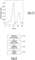
- Figure 6 shows possible interruptions that a car may experience while turning left at an intersection with a unprotected enforcement (i.e., circular traffic light).
- a unprotected enforcement i.e., circular traffic light.
- the most common (as stated in the driver manual) left-turn maneuver works as follows. A left-turning car first enters the intersection after the green light comes on and then suspends its turn if there is an oncoming car from the opposite direction. Upon resuming the left turn, the car needs to pay attention to, and prepare to pause for, pedestrians crossing the street/road it is turning onto. Finally, the left-turning car completes the turn by exiting the intersection.
- interruptions occur rarely at intersections with protected enforcements, because the protected traffic signal (i.e., the left-turn traffic arrow) grants left-turning cars an exclusive traffic phase, hence preventing pedestrians and oncoming vehicles from crossing the intersection.
- the protected traffic signal i.e., the left-turn traffic arrow
- one of the main purposes of enforcing left-turns protection is to reduce the left-turning cars' conflicts with the oncoming traffic and crossing pedestrians.
- the TurnsMap system 10 uses angular speed data (e.g., from a gyroscope) to detect the interruptions. Since an interruption is essentially a pause of steering maneuver, the coordinate-aligned gyroscope data (i.e., angular speed) can capture the differences between normal and interrupted left-turns. While reference is made to angular velocity of the vehicle in this disclosure, it is readily understood that metrics related to the motion of the vehicle can also be used to detect interruptions made during left turns.
- Figures 7A-7C show the gyroscope readings of three scenarios: no interruption, interruption at the middle of an intersection (interruption 1 in Fig. 6 ), and a left turn with an interruption at the crosswalk (interruption 2 in Fig. 6 ), respectively.
- the gyroscope reading captures the car's angular speed (w).
- the driver makes a (normal) left turn without interruption, s/he first turns the steering wheel counter-clockwise, creating a monotonic increase of the vehicle's angular speed w as seen in Figure 7A .
- the driver then makes a clockwise turn of steering wheel until the car's orientation returns to straight, or w returns to approximately 0.
- a smooth left turn generates a single bump in the gyroscope reading.
- the system preferably extracts signal features indicative of left turns (e.g., bumps) from the IMU and GPS sensor data of the driver's smartphone as indicated at 23 of Figure 2 .
- signal features indicative of left turns e.g., bumps
- the example technique detects vehicle steering maneuvers by harvesting the morphological patterns of the sequential gyroscope data.
- the technique analyzes the gyroscope data to detect the start and end points of a "bump"-shaped curve by using a predetermined threshold derived from the common driving behavior.
- the TurnsMap system 10 faces a unique challenge - one bump may not contain a complete left turn since the turn can be interrupted (e.g., by crossing pedestrian/cars), thus generating two or more bumps in a left turn.
- the neighboring bumps are geo-located adjacently. Specifically, if neighboring bumps on the same IMU trace are adjacent in geo-distance, i.e., great-circle distance between two points on the surface of the earth, then they together represent a single left-turn maneuver.
- geo-distance i.e., great-circle distance between two points on the surface of the earth
- the geo-distance between the centroids of geolocations of those bumps (let loc cur and loc pend denote the centroid of the geolocation of the current bump and the pending bump, respectively) is within a threshold ⁇ geo .
- the centroid is derived by using FindCentroid ( ⁇ ), which is the mean of latitude and longitude readings. Note that this averaging step can also mitigate the fluctuation of GPS readings.
- the geo-distance is calculated by using the haversine formula. Thus, if the current and pending bumps are from the same left turn, the current bump is merged with the pending bump(s).
- the current bump is a complete left turn.
- start and end timestamps i.e., t cur,start , and t cur,end
- t cur,start , and t cur,end can be used for cropping the left-turn data snippets from all necessary time-series data traces - gyroscope, accelerometer, and geolocation data. This example technique is summarized in the algorithm set forth below.
- L is the list that stores all left-turn tuples.
- a left turn made by the vehicle is classified at 26 as being a protected left turn based on number of bumps identified in the sensor signal, where the protected left turn has a traffic indicia which causes a time period assigned exclusively to making a left turn. More specifically, a left turn is classified as being a protected left turn in response to identifying one bump in the sensor signal; whereas, a left turn is classified as being an unprotected left turn in response to identifying two bumps in the sensor signal. It is to be understood that only the relevant steps of the data collection app are discussed in relation to Figure 1 , but that other software-implemented instructions may be needed to control and manage the overall operation of the data collection app.
- a plurality of feature vectors are received at 82, for example by the data mining component 14 of the TurnsMap system 10.
- the feature vectors in the plurality of feature vectors are indicative of a left turn made by a vehicle and may have been collected by the data collection component 12.
- Each feature vector includes geolocation of the vehicle during the left turn and time series data for the angular speed of the vehicle during the left turn.
- the plurality of feature vectors are spatially clustered at 83 based on geolocation to form one or more clusters of feature vectors.
- the feature vectors are clustered using a density-based spatial clustering of applications with noise method (DBSCAN) although other clustering methods are contemplated by this disclosure.
- DBSCAN is a density-based algorithm that does not require a pre-defined number of clusters and is proven to perform well in clustering spatial data.
- DBSCAN ( ⁇ ) uses the centroid of each left-turn instance as the clustering criterion.
- the output (i.e., C) of DBSCAN ( ⁇ ) is a collection of clusters, which is comprised of left-turn tuples ( Is ).
- Gyro, Acc, Loc denote the thus-aggregated gyroscope, accelerometer, and location traces, respectively.
- X is the list of left-turn hotspot tuples.
- Figure 9 shows part of a clustering result.
- the location traces are interpolated to show the trajectory of a left-turning car.
- one intersection is not covered due to lack of driving data, but the other intersections are clustered by DBSCAN.
- DBSCAN DBSCAN
- a ground truth is assigned at 84 to each of the clusters. Due to the lack of a ground truth for each hotspot's left-turn setting, the system will need to collect the ground truth from scratch.
- a human-in-the-loop method is used to collect this information efficiently.
- an annotation task is outsourced to the crowd on Amazon Mechanical Turk (AMT) and Google StreetView - a large-scale image database that includes traffic scene information collected by mapping cars - is used as the accessible reference for the annotators to identify the left-turn protection setting of each hotspot.
- AMT Amazon Mechanical Turk
- Google StreetView a large-scale image database that includes traffic scene information collected by mapping cars - is used as the accessible reference for the annotators to identify the left-turn protection setting of each hotspot.
- An easy-to-follow annotation process is essential to minimize the participants' confusion for good quality of annotation.
- an interactive labeling/annotation webpage as the participants' working platform. Described below is how to annotate each left-turn hotspot on this webpage.
- a backend system a php script running on the server for hosting the webpage
- the annotator then needs to inspect the StreetView (i.e., by zooming in/out and changing the viewing angle) to get a clear view of the left-turn protection setting.
- Option 1 represents the protected left-turn signal
- options 2-5 represent unprotected left turns
- option 6 signifies none of the five aforementioned options according to the participant's perception/judgement, e.g., parking lots and/or road segments without any StreetView image.
- the backend system will record the annotator's input, and a new hotspot will be displayed on the webpage.
- Quality of the collected annotations can be enhanced as follows. First, one can ensure the annotators' competence by only recruiting "master” workers - elite workers who have demonstrated superior performance in their previous tasks and have been acknowledged by the corresponding requesters.
- annotated data need to be filtered and refined for accuracy. To do so, one can ensure that each left-turn hotspot received multiple annotations from the participants. Specifically, any left-turn hotspot with less than three annotations are discarded. Then, for each remaining hotspot, we apply simple majority voting to determine its annotation. That is, we select the annotation with the largest number of repetitions. Note that a similar criterion is also commonly used in other large-scale ground truth collections, e.g., ImageNet and DeepDrive.
- each hotspot has an average of 5.47 annotations.
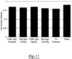
- the quality of the dataset was assessed by inspecting the inter-annotator reliability of each left-turn protection setting, which measures the consistency among different annotators. It is a commonly used evaluation metric for assessing the quality of annotations collected from the crowd. As shown in Figure 11 , the inter-annotator reliability of each category is around 85%.
- the annotation result can also help one to understand the performance of left-turn hotspot extraction. Since false detections of a hotspot may be due to cars' swerving in open areas (e.g., parking lots), one can use the annotators' feedback on each hotspot to inspect if the hotspot is indeed a road segment that can facilitate left turns. According to the aggregated annotation results, 96.5% (965 out of 1,000) of the annotated hotspots are road segments that can be categorized into one of the five scenarios. Thus, left-turn hotspot extractions are shown to be able to accurately identify road segments that can facilitate left turns.
- a dataset is constructed using the annotated hotspots.
- hotspot i denote its ground truth as y i if it has an annotation that passed our quality control test.
- X x 1 , ... , x i ... , x N 1
- Y y 1 , ... , y i , ... , y N 1
- y ⁇ ⁇ 1, 2,3,4, 5 ⁇ as shown in Fig. 10 ; i ⁇ ⁇ 1, ..., N 1 ⁇ , N 1 is the number of valid hotspots with valid annotations.
- N 1 965. Note that by associating X with Y, one can have ( x, y ) pairs, which can be applied in supervised machine learning.
- Classification of protected/unprotected left turns based on mobile sensing data at hotspots ( X ) can be cast as a supervised learning problem for binary classification of time-series data.
- a classifier is trained at 85 with the feature vectors in the one or more clusters using supervised learning.
- the supervised machine learning problem can be formally state as follows. Given N 1 pairs of data of the form ⁇ ( x 1 , y 1 ) , ..., (x n 1 , y n 1 ) ⁇ the objective is to learn a model X ⁇ Y, where y is an annotation, x is the measurement represented as a tuple of several time-series traces.
- each observation x is a single data trace (vector).
- each observation in the training set is a 2-dimensional vector of IMU sensor readings.
- the TurnsMap system each observation is a tuple of data traces.
- the data of each observation x is comprised of gyro and acc , which are sets of gyroscope and accelerometer data vectors of different lengths. Without such data formation, it is not possible to distinguish left-turn settings based on one time-series data vector.
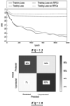
- the left side frame in Figure 12 illustrates the accelerometer and gyroscope data traces collected from an unprotected left turn. Note that not all traces exhibit the interruption pattern, i.e., some of the collected time-series traces are as smooth as if they were collected from a protected left turn. Therefore, a machine learning pipeline needs to pre-process the time-series data tuple to form data that can be used as input for the machine learning algorithm.
- this disclosure proposes a deep learning pipeline that is comprised by a novel data augmentation process and a deep Recurrent Neural Network (RNN) based on Long-Short Term Memory (LSTM) cells.
- the goal of the data augmentation is to construct and expand the training dataset without undermining the underlying pattern.
- randomly permuted concatenation (RPCat) is applied to each hotspot data, i.e., X.
- RPCat has two steps: (i) expand the set of observations by permuting the sequence within x ; and (ii) concatenate the data traces of each permuted observation.
- NLP natural language processing
- RPCat is illustrated using an example shown in Figure 12 .
- a hotspot's data x is comprised of J gyroscope and J accelerometer traces (i.e., J is the number of the clustered left-turn maneuvers at this hotspot).
- the sequence of data traces in x is originally organized according to the timestamp (e.g., epoch time in the TurnsMap system) of the collected data.
- timestamp e.g., epoch time in the TurnsMap system
- different left turns at this hotspot are independent of each other. That is, P T 1 , ... , T j , ... , T J , where T j is the j th left-turn event and P(T j ) is the probability of T j 's occurrence. Due to the independence of different left turns, the arrival sequence of these data traces should not affect the classification result.
- RPCat reflects this insight and reconstructs x as shown in the second frame in Figure 12 . Specifically, RPCat firstly permutes the sequence of data traces in x and then concatenates the data. Aftereach permutation, RPCat generates a new sequence of data traces. Finally, to unify the data size for machine learning, resize each trace to length FixLen. Repeat RPCat J times to obtain a J X FixLen X 2 tensor for x . One can execute the above process for all N 1 hotspots. Finally, after reshaping and splitting the data based on batch size, transfer the data into the input tensor for the LSTM network.
- FixLen 800. It is importation to note that the permutation does not undermine the sequential pattern of the data for the system.
- the sequential pattern e.g., interruptions
- the sequential pattern of left-turn data resides in each left-turn maneuver. Since the permutation only shuffles the order of left turns, it does not change the sequential pattern of each left-turn data.
- a deep RNN framework with LSTM cells is used to learn the underlying pattern(s) from the augmented data.
- LSTM has proven advantages over other machine learning algorithms, such as SVM, random forest, convolutional neural network, etc., for classifying sequential data.
- machine learning algorithms such as SVM, random forest, convolutional neural network, etc.
- the use of an RNN architecture is not limiting and other types of machine learning algorithms can be used within the broader aspects of this disclosure.
- each LSTM cell uses a forget gate to adjust the extent of passing the state variable to the next unit - an important feature for capturing dependencies through time.
- the forget gate design is shown to have a desirable effect on mitigating the vanishing gradient problem, a common limitation for the classical RNN architecture that may restrict the network from learning the pattern from sequential observations.
- Stacked LSTM is used since a deeper hierarchical structure enables the network to gain more accurate understanding of the intrinsic pattern by disseminating the learning task to each layer.
- the hyper-parameter settings of the network are: 2 LSTM layers, 32 LSTM cells per layer, batch size of 300, and the training rate of 0.001.
- the tanh function is used for updating the cell and hidden state, whereas the sigmoid function is used for the gates in LSTM cells.
- a 0.5 dropout rate is applied in each LSTM layer.
- the Adam optimizer is used for iteratively updating network weights.
- the network feeds the thus-learnt feature vector (1 X 32) into a softmax layer for generating the classification result.
- both training and testing losses decrease with the increasing number of epoch (in neural network epoch, one epoch means the number of times the entire dataset is processed by the algorithm). Specifically, training and testing losses are stabilized at 0.4 and 0.45, respectively, after about 900 epochs.
- An evaluation of the machine learning pipeline is described below.
- the machine learning pipeline can be evaluated using cross-validated performance metrics.
- Figure 14 shows a confusion matrix where each row represents the actual class and each column represents the predicted class.
- Figure 15 shows the precision, recall and F-1 score, where precision represents the ratio of true positive detections to the total positive detections, and recall represents the classifier's sensitivity with the ratio of true positive detections to the total actual positive observations. Accordingly, the classifier can identify different left-turn settings with high performance. Note that the number of instances of unprotected settings takes a large portion in the dataset due to its popularity in real-world, the classifier is not biased as evidenced by the performance metrics shown in Figure 15 . This shows the model trained on the augmented (and thus balanced) dataset is not biased and the LSTM framework successfully learns the feature(s) for differentiating left-turn protection schemes.
- the TurnsMap system errs on the safe side of misclassifications to mitigate the impact of erroneous classifications. Specifically, it has a lower rate of misclassifying unprotected left turns as protected ones than that of classifying protected left turns as unprotected ones. This means that while identifying protected left turns with good accuracy, the system achieves better performance in identifying the unprotected left turns.
- TurnsMap The performance of the TurnsMap system is essential for many applications, such as finding the safest left turns for novice drivers and route planning for self-driving cars.
- the classification performance is examined based on the unbalanced dataset.
- the threshold i.e., cutoff probability
- the ROC Receiver Operator Characteristic
- PR Precision-Recall
- both the ROC and PR curves show the efficacy of the classifier. Specifically, both curves have significantly better performance than their corresponding reference lines (i.e., random guess). Moreover, the area under curve (AUC) for ROC and PR curves is 0.954 and 0.926, respectively.
- the proposed model's performance is compared with the models trained by other learning algorithms based on the augmented dataset, and the averaged performance metrics are plotted in Figure 18 , where a standard RNN, which is known to have good performance for sequential data, was tested.
- a standard RNN which is known to have good performance for sequential data
- the standard RNN cell lacks gates (e.g., forget gate) for learning the sequential dependencies that may have varying (e.g., short- or long-term) timespans.
- the proposed model is compared with kernelized support vector machine (SVM), and random forest (RF).
- SVM kernelized support vector machine
- RF random forest
- the RNN uses the same hyper-parameter setting as the LSTM network. 200 decision trees were used for the RF algorithm. Note that the same training data setting was used for testing different algorithms. That is, the performance of RF and SVM with feature vector optimization is not the focus of this disclosure.
- LSTM outperforms the others in all metrics considered.
- the advantages of LSTM over others is its capability of capturing dependencies through time.
- RNN cells are susceptible to the vanishing gradient decent problem, making it very hard to capture the dependencies in time-series data.
- SVM has a low average F-1 score, because it misclassified many unprotected hotspots as protected ones while showing good performance in detecting protected hotspots.
- TurnsMap system Since left-turn enforcement is critical for driving safety, the TurnsMap system has potential for use in various app scenarios, such as navigation systems for both human- and self-driving cars, and reporting unprotected left-turn hotspots to the local transportation department.
- route/trip planning selects the route by minimizing the estimated time of arrival (ETA).
- ETA estimated time of arrival
- the navigation system may generate a route with many risky unprotected left turns.
- TurnsMap system's exemplary application is augmenting existing navigation app with left turn setting information at intersections. That is, with the left-turn information discovered by the TurnsMap system, the system can provide this information with the collaborating navigation app to plan a route that also considers left-turn safety at intersections- which is not yet achieved functionality by using state-of-the-art approaches. Specifically, users of a navigation app can enable unprotected left turn avoidance in the setting of the app. Thus, the app can suggest an alternative route which has safer turning maneuvers (e.g., right turns).
- the techniques described herein may be implemented by one or more computer programs executed by one or more processors.
- the computer programs include processor-executable instructions that are stored on a non-transitory tangible computer readable medium.
- the computer programs may also include stored data.
- Non-limiting examples of the non-transitory tangible computer readable medium are nonvolatile memory, magnetic storage, and optical storage.
- the present disclosure also relates to an apparatus for performing the operations herein.
- This apparatus may be specially constructed for the required purposes, or it may comprise a computer selectively activated or reconfigured by a computer program stored on a computer readable medium that can be accessed by the computer.
- a computer program may be stored in a tangible computer readable storage medium, such as, but is not limited to, any type of disk including floppy disks, optical disks, CD-ROMs, magnetic-optical disks, read-only memories (ROMs), random access memories (RAMs), EPROMs, EEPROMs, magnetic or optical cards, application specific integrated circuits (ASICs), or any type of media suitable for storing electronic instructions, and each coupled to a computer system bus.
- the computers referred to in the specification may include a single processor or may be architectures employing multiple processor designs for increased computing capability.
Landscapes
- Engineering & Computer Science (AREA)
- Remote Sensing (AREA)
- Radar, Positioning & Navigation (AREA)
- Physics & Mathematics (AREA)
- General Physics & Mathematics (AREA)
- Theoretical Computer Science (AREA)
- General Engineering & Computer Science (AREA)
- Data Mining & Analysis (AREA)
- Automation & Control Theory (AREA)
- Biophysics (AREA)
- Software Systems (AREA)
- Molecular Biology (AREA)
- Computing Systems (AREA)
- Evolutionary Computation (AREA)
- Computational Linguistics (AREA)
- Mathematical Physics (AREA)
- General Health & Medical Sciences (AREA)
- Biomedical Technology (AREA)
- Artificial Intelligence (AREA)
- Life Sciences & Earth Sciences (AREA)
- Health & Medical Sciences (AREA)
- Databases & Information Systems (AREA)
- Computer Networks & Wireless Communication (AREA)
- Traffic Control Systems (AREA)
- Navigation (AREA)
Claims (14)
- Procédé de classification de virages à gauche d'un véhicule, comprenant :la réception (21), par un processeur d'un dispositif mobile, d'un signal de capteur provenant d'un capteur résidant dans le dispositif mobile pendant que le véhicule se déplace, où le signal indique une vitesse angulaire du véhicule ;l'identification, par le processeur, d'une ou plusieurs bosses dans le signal de capteur ;la classification (26), par le processeur, d'un virage à gauche effectué par le véhicule comme étant un virage à gauche protégé sur la base du nombre de bosses identifiées dans le signal de capteur, dans lequel le virage à gauche est classifié comme un virage à gauche protégé en réponse à l'identification d'une bosse dans le signal de capteur et comme un virage à gauche non protégé en réponse à l'identification de deux bosses dans le signal de capteur ; etle stockage des classifications obtenues dans une base de données.
- Procédé selon la revendication 1 comprenant en outre la détection, par le processeur, d'un virage à gauche effectué par le véhicule à l'aide de signaux provenant d'un ou de plusieurs capteurs résidant dans le dispositif mobile ; et
l'identification de la ou des bosses dans le signal en réponse à la détection d'un virage à gauche du véhicule. - Procédé selon la revendication 1 comprenant en outre :la conversion, par le processeur, du signal de capteur provenant d'un système de coordonnées associé au dispositif mobile en un système de coordonnées géographiques, où le signal de capteur est rapporté par le capteur par rapport au système de coordonnées associé au dispositif mobile; etle calcul, par le processeur, d'un signal de vitesse angulaire à partir du signal de capteur converti, où le signal de vitesse angulaire indique la vitesse angulaire du véhicule autour d'un axe vertical du système de coordonnées géographiques.
- Procédé selon la revendication 1 comprenant en outrela réception, par le processeur, d'une géolocalisation du dispositif mobile ;l'association, par le processeur, de la géolocalisation aux points de données du signal de capteur, où le signal de capteur est exprimé sous la forme d'une série temporelle ; etle fait de déterminer, par le processeur, que deux bosses dans le signal de capteur font partie du même virage à gauche sur la base de la proximité de la géolocalisation des deux bosses l'une par rapport à l'autre.
- Procédé selon la revendication 4 comprenant en outre la réception de la géolocalisation du dispositif mobile comme lectures d'un système de positionnement global (GPS) résidant dans le dispositif mobile.
- Procédé selon la revendication 1 comprenant en outre la mesure de la vitesse angulaire du véhicule à l'aide d'un gyroscope résidant dans le dispositif mobile.
- Procédé selon la revendication 1 comprenant en outrela construction d'un vecteur de caractéristiques à partir de données reçues de la part du capteur ; etl'apprentissage d'un classifieur en partie sur la base du vecteur de caractéristiques, où le classifieur produit une probabilité qu'un virage à gauche effectué par le véhicule est un virage à gauche protégé.
- Procédé selon la revendication 8, dans lequel le classifieur est en outre défini comme un réseau neuronal.
- Procédé de classification de virages à gauche effectués par un véhicule, comprenant :la réception (82), par un processeur, d'une pluralité de vecteurs de caractéristiques, où chaque vecteur de caractéristiques indique un virage à gauche effectué par des véhicule et chaque vecteur de caractéristiques comporte la géolocalisation du véhicule pendant le virage à gauche et des données de série temporelle pour la vitesse angulaire du véhicule pendant le virage à gauche ;le regroupement spatial (83), par le processeur, de la pluralité de vecteurs de caractéristiques sur la base de la géolocalisation pour former un ou plusieurs groupes de vecteurs de caractéristiques ;l'attribution (84), par le processeur, d'une vérité de terrain au ou aux groupes ;l'apprentissage (85), par le processeur, d'un classifieur avec des vecteurs de caractéristiques dans le ou les groupes à l'aide de l'apprentissage supervisé, où le classifieur produit une probabilité qu'un virage à gauche effectué par le véhicule est un virage à gauche protégé, dans lequel le virage à gauche est classifié comme un virage à gauche protégé si une bosse est identifiée dans les données de série temporelle, et comme un virage à gauche non protégé si deux bosses sont identifiées dans les données de série temporelle ; etle stockage des classifications obtenues dans une base de données.
- Procédé selon la revendication 9, comprenant en outrela collecte de données de capteurs à partir d'un ou plusieurs capteurs résidant dans un dispositif mobile pendant qu'un véhicule effectue un virage à gauche ;la construction d'un vecteur de caractéristiques à partir des données de capteur associées à chaque virage à gauche ; etle téléchargement des vecteurs de caractéristiques à partir du dispositif mobile vers un serveur.
- Procédé selon la revendication 9, dans lequel chaque vecteur de caractéristiques comporte en outre des données de série temporelle provenant d'un accéléromètre du véhicule pendant le virage à gauche.
- Procédé selon la revendication 9 comprenant en outre, pour chaque groupe, la concaténation des données de série temporelle provenant des vecteurs de caractéristiques appartenant à un groupe donné pour former des données d'apprentissage pour le classifieur, et la permutation aléatoire de la séquence de données de série temporelle provenant des vecteurs de caractéristiques appartenant au groupe donné pour former des données d'apprentissage supplémentaires.
- Procédé selon la revendication 9 comprenant en outre le regroupement spatial de la pluralité de vecteurs de caractéristiques à l'aide d'un procédé de regroupement spatial basé sur la densité des applications avec bruit.
- Procédé selon la revendication 9, dans lequel le classifieur est défini en outre comme un réseau neuronal récurrent.
Applications Claiming Priority (3)
| Application Number | Priority Date | Filing Date | Title |
|---|---|---|---|
| US201962896926P | 2019-09-06 | 2019-09-06 | |
| US17/012,176 US11879744B2 (en) | 2019-09-06 | 2020-09-04 | Inferring left-turn information from mobile crowdsensing |
| PCT/US2020/049592 WO2021046489A1 (fr) | 2019-09-06 | 2020-09-05 | Déduction d'informations de tourne-à-gauche à partir de mégacollecte |
Publications (3)
| Publication Number | Publication Date |
|---|---|
| EP4026111A1 EP4026111A1 (fr) | 2022-07-13 |
| EP4026111A4 EP4026111A4 (fr) | 2023-09-27 |
| EP4026111B1 true EP4026111B1 (fr) | 2025-06-25 |
Family
ID=74849940
Family Applications (1)
| Application Number | Title | Priority Date | Filing Date |
|---|---|---|---|
| EP20860985.9A Active EP4026111B1 (fr) | 2019-09-06 | 2020-09-05 | Déduction d'informations de tourne-à-gauche à partir de mégacollecte |
Country Status (3)
| Country | Link |
|---|---|
| US (1) | US11879744B2 (fr) |
| EP (1) | EP4026111B1 (fr) |
| WO (1) | WO2021046489A1 (fr) |
Families Citing this family (3)
| Publication number | Priority date | Publication date | Assignee | Title |
|---|---|---|---|---|
| US12429355B2 (en) * | 2023-03-08 | 2025-09-30 | Microsoft Technology Licensing, Llc | Mining map data to predict turn restrictions |
| US12361829B2 (en) * | 2023-04-21 | 2025-07-15 | Toyota Motor Engineering & Manufacturing North America, Inc. | Omnidirectional collision avoidance |
| US20250021811A1 (en) * | 2023-07-11 | 2025-01-16 | National Yang Ming Chiao Tung University | Early classification method and electrical device for multi-objective optimization |
Family Cites Families (12)
| Publication number | Priority date | Publication date | Assignee | Title |
|---|---|---|---|---|
| JP2009190650A (ja) * | 2008-02-18 | 2009-08-27 | Panasonic Corp | 旋回方向指示装置 |
| KR20140088640A (ko) | 2012-12-31 | 2014-07-11 | 현대자동차주식회사 | 좌회전 보조 시스템 및 좌회전 보조 방법 |
| US9834222B2 (en) | 2015-04-24 | 2017-12-05 | The Regents Of The University Of Michigan | Detecting vehicle maneuvers with mobile phones |
| KR101663511B1 (ko) * | 2015-04-30 | 2016-10-14 | 엘지전자 주식회사 | 차량 운전 보조 장치, 차량 운전 보조 장치의 제어 방법 및 차량 |
| US9751506B2 (en) | 2015-10-27 | 2017-09-05 | GM Global Technology Operations LLC | Algorithms for avoiding automotive crashes at left and right turn intersections |
| US9928667B2 (en) | 2015-12-21 | 2018-03-27 | International Business Machines Corporation | Determining vehicle occupancy using sensors |
| SG11201909943SA (en) | 2017-05-01 | 2019-11-28 | Parkofon Inc | System and method for high accuracy location determination and parking |
| WO2019048034A1 (fr) | 2017-09-06 | 2019-03-14 | Swiss Reinsurance Company Ltd. | Système électronique d'identification de suivi et de consignation pour dispositifs télématiques, et procédé correspondant associé |
| US10585434B2 (en) | 2018-01-10 | 2020-03-10 | GM Global Technology Operations LLC | Relaxable turn boundaries for autonomous vehicles |
| US11919531B2 (en) * | 2018-01-31 | 2024-03-05 | Direct Current Capital LLC | Method for customizing motion characteristics of an autonomous vehicle for a user |
| US11908253B2 (en) * | 2018-12-12 | 2024-02-20 | Gm Cruise Holdings Llc | Dynamic data preservation based on autonomous vehicle performance needs |
| US11747142B2 (en) * | 2019-04-30 | 2023-09-05 | Stmicroelectronics, Inc. | Inertial navigation system capable of dead reckoning in vehicles |
-
2020
- 2020-09-04 US US17/012,176 patent/US11879744B2/en active Active
- 2020-09-05 WO PCT/US2020/049592 patent/WO2021046489A1/fr not_active Ceased
- 2020-09-05 EP EP20860985.9A patent/EP4026111B1/fr active Active
Also Published As
| Publication number | Publication date |
|---|---|
| US20210072039A1 (en) | 2021-03-11 |
| US11879744B2 (en) | 2024-01-23 |
| EP4026111A1 (fr) | 2022-07-13 |
| EP4026111A4 (fr) | 2023-09-27 |
| WO2021046489A1 (fr) | 2021-03-11 |
Similar Documents
| Publication | Publication Date | Title |
|---|---|---|
| US11776279B2 (en) | Method and apparatus for providing unknown moving object detection | |
| EP4211601B1 (fr) | Procédé de détection électronique de familiarité d'itinéraires de voyage | |
| You et al. | Carsafe app: Alerting drowsy and distracted drivers using dual cameras on smartphones | |
| US10579058B2 (en) | Apparatus and method for generating training data to train neural network determining information associated with road included in image | |
| Zhang et al. | Data-driven intelligent transportation systems: A survey | |
| US20190050711A1 (en) | Method, storage medium and electronic device for detecting vehicle crashes | |
| EP4026111B1 (fr) | Déduction d'informations de tourne-à-gauche à partir de mégacollecte | |
| Sun et al. | Combining machine learning and dynamic time wrapping for vehicle driving event detection using smartphones | |
| Anik et al. | inTformer: a time-embedded attention-based transformer for Crash Likelihood Prediction at intersections using connected Vehicle Data | |
| Cheng et al. | Modeling mixed traffic in shared space using lstm with probability density mapping | |
| Chen et al. | Turnsmap: enhancing driving safety at intersections with mobile crowdsensing and deep learning | |
| St-Aubin | Driver behaviour and road safety analysis using computer vision and applications in roundabout safety | |
| Bhandari et al. | Fullstop: A camera-assisted system for characterizing unsafe bus stopping | |
| Ahsan et al. | An ensemble time-embedded transformer model for traffic conflict prediction at RRFB pedestrian crossings | |
| AU2023213179B2 (en) | Crowdsourcing techniques to deploy artificial intelligence systems | |
| Uchiyama et al. | Risky traffic situation detection and classification using smartphones | |
| Grigoropoulos et al. | Detection and classification of bicyclist group behavior for automated vehicle applications | |
| CN113327414A (zh) | 车辆逆行检测方法、装置、计算机设备和存储介质 | |
| Das et al. | Dribe: on-road mobile telemetry for locality-neutral driving behavior annotation | |
| CN117882117A (zh) | 图像处理方法、装置和系统、可移动平台 | |
| Aradhya et al. | Real time vehicle tracking, information retrieval and motion analysis using machine learning | |
| CN113762030A (zh) | 数据处理方法、装置、计算机设备及存储介质 | |
| Martinelli et al. | A Method for Finding Distance in Real-Time Car Detection through Object Detection | |
| Jia et al. | Cloud-Based Collaborative Road Condition Monitoring Using In-Vehicle Smartphone Data | |
| Das et al. | Pervasive Sensing to Correlate Vehicle Driving Behavior With City-Scale Traffic Dynamics |
Legal Events
| Date | Code | Title | Description |
|---|---|---|---|
| STAA | Information on the status of an ep patent application or granted ep patent |
Free format text: STATUS: THE INTERNATIONAL PUBLICATION HAS BEEN MADE |
|
| PUAI | Public reference made under article 153(3) epc to a published international application that has entered the european phase |
Free format text: ORIGINAL CODE: 0009012 |
|
| STAA | Information on the status of an ep patent application or granted ep patent |
Free format text: STATUS: REQUEST FOR EXAMINATION WAS MADE |
|
| 17P | Request for examination filed |
Effective date: 20220324 |
|
| AK | Designated contracting states |
Kind code of ref document: A1 Designated state(s): AL AT BE BG CH CY CZ DE DK EE ES FI FR GB GR HR HU IE IS IT LI LT LU LV MC MK MT NL NO PL PT RO RS SE SI SK SM TR |
|
| DAV | Request for validation of the european patent (deleted) | ||
| DAX | Request for extension of the european patent (deleted) | ||
| P01 | Opt-out of the competence of the unified patent court (upc) registered |
Effective date: 20230502 |
|
| REG | Reference to a national code |
Ref country code: DE Ref legal event code: R079 Free format text: PREVIOUS MAIN CLASS: G08G0001096800 Ipc: G01C0021320000 Ref country code: DE Ref legal event code: R079 Ref document number: 602020053484 Country of ref document: DE Free format text: PREVIOUS MAIN CLASS: G08G0001096800 Ipc: G01C0021320000 |
|
| A4 | Supplementary search report drawn up and despatched |
Effective date: 20230829 |
|
| RIC1 | Information provided on ipc code assigned before grant |
Ipc: G06N 3/08 20060101ALI20230823BHEP Ipc: G06N 3/048 20230101ALI20230823BHEP Ipc: G06N 3/045 20230101ALI20230823BHEP Ipc: G06N 3/044 20230101ALI20230823BHEP Ipc: G08G 1/16 20060101ALI20230823BHEP Ipc: G08G 1/0968 20060101ALI20230823BHEP Ipc: G01C 21/34 20060101ALI20230823BHEP Ipc: G01C 21/32 20060101AFI20230823BHEP |
|
| GRAP | Despatch of communication of intention to grant a patent |
Free format text: ORIGINAL CODE: EPIDOSNIGR1 |
|
| STAA | Information on the status of an ep patent application or granted ep patent |
Free format text: STATUS: GRANT OF PATENT IS INTENDED |
|
| RIC1 | Information provided on ipc code assigned before grant |
Ipc: G06N 3/08 20060101ALI20240716BHEP Ipc: G06N 3/048 20230101ALI20240716BHEP Ipc: G06N 3/045 20230101ALI20240716BHEP Ipc: G06N 3/044 20230101ALI20240716BHEP Ipc: G01C 21/00 20060101ALI20240716BHEP Ipc: G01C 21/34 20060101ALI20240716BHEP Ipc: G01C 21/32 20060101AFI20240716BHEP |
|
| INTG | Intention to grant announced |
Effective date: 20240819 |
|
| GRAJ | Information related to disapproval of communication of intention to grant by the applicant or resumption of examination proceedings by the epo deleted |
Free format text: ORIGINAL CODE: EPIDOSDIGR1 |
|
| STAA | Information on the status of an ep patent application or granted ep patent |
Free format text: STATUS: REQUEST FOR EXAMINATION WAS MADE |
|
| GRAP | Despatch of communication of intention to grant a patent |
Free format text: ORIGINAL CODE: EPIDOSNIGR1 |
|
| STAA | Information on the status of an ep patent application or granted ep patent |
Free format text: STATUS: GRANT OF PATENT IS INTENDED |
|
| INTC | Intention to grant announced (deleted) | ||
| INTG | Intention to grant announced |
Effective date: 20250122 |
|
| GRAS | Grant fee paid |
Free format text: ORIGINAL CODE: EPIDOSNIGR3 |
|
| GRAA | (expected) grant |
Free format text: ORIGINAL CODE: 0009210 |
|
| STAA | Information on the status of an ep patent application or granted ep patent |
Free format text: STATUS: THE PATENT HAS BEEN GRANTED |
|
| AK | Designated contracting states |
Kind code of ref document: B1 Designated state(s): AL AT BE BG CH CY CZ DE DK EE ES FI FR GB GR HR HU IE IS IT LI LT LU LV MC MK MT NL NO PL PT RO RS SE SI SK SM TR |
|
| REG | Reference to a national code |
Ref country code: GB Ref legal event code: FG4D |
|
| REG | Reference to a national code |
Ref country code: CH Ref legal event code: EP |
|
| REG | Reference to a national code |
Ref country code: CH Ref legal event code: EP |
|
| REG | Reference to a national code |
Ref country code: IE Ref legal event code: FG4D |
|
| REG | Reference to a national code |
Ref country code: DE Ref legal event code: R096 Ref document number: 602020053484 Country of ref document: DE |
|
| PG25 | Lapsed in a contracting state [announced via postgrant information from national office to epo] |
Ref country code: FI Free format text: LAPSE BECAUSE OF FAILURE TO SUBMIT A TRANSLATION OF THE DESCRIPTION OR TO PAY THE FEE WITHIN THE PRESCRIBED TIME-LIMIT Effective date: 20250625 |
|
| PGFP | Annual fee paid to national office [announced via postgrant information from national office to epo] |
Ref country code: DE Payment date: 20250919 Year of fee payment: 6 |
|
| REG | Reference to a national code |
Ref country code: LT Ref legal event code: MG9D |
|
| PG25 | Lapsed in a contracting state [announced via postgrant information from national office to epo] |
Ref country code: NO Free format text: LAPSE BECAUSE OF FAILURE TO SUBMIT A TRANSLATION OF THE DESCRIPTION OR TO PAY THE FEE WITHIN THE PRESCRIBED TIME-LIMIT Effective date: 20250925 Ref country code: GR Free format text: LAPSE BECAUSE OF FAILURE TO SUBMIT A TRANSLATION OF THE DESCRIPTION OR TO PAY THE FEE WITHIN THE PRESCRIBED TIME-LIMIT Effective date: 20250926 |
|
| PG25 | Lapsed in a contracting state [announced via postgrant information from national office to epo] |
Ref country code: BG Free format text: LAPSE BECAUSE OF FAILURE TO SUBMIT A TRANSLATION OF THE DESCRIPTION OR TO PAY THE FEE WITHIN THE PRESCRIBED TIME-LIMIT Effective date: 20250625 |
|
| PG25 | Lapsed in a contracting state [announced via postgrant information from national office to epo] |
Ref country code: HR Free format text: LAPSE BECAUSE OF FAILURE TO SUBMIT A TRANSLATION OF THE DESCRIPTION OR TO PAY THE FEE WITHIN THE PRESCRIBED TIME-LIMIT Effective date: 20250625 |
|
| PGFP | Annual fee paid to national office [announced via postgrant information from national office to epo] |
Ref country code: FR Payment date: 20250922 Year of fee payment: 6 |
|
| PG25 | Lapsed in a contracting state [announced via postgrant information from national office to epo] |
Ref country code: RS Free format text: LAPSE BECAUSE OF FAILURE TO SUBMIT A TRANSLATION OF THE DESCRIPTION OR TO PAY THE FEE WITHIN THE PRESCRIBED TIME-LIMIT Effective date: 20250925 |
|
| PG25 | Lapsed in a contracting state [announced via postgrant information from national office to epo] |
Ref country code: LV Free format text: LAPSE BECAUSE OF FAILURE TO SUBMIT A TRANSLATION OF THE DESCRIPTION OR TO PAY THE FEE WITHIN THE PRESCRIBED TIME-LIMIT Effective date: 20250625 |
|
| REG | Reference to a national code |
Ref country code: NL Ref legal event code: MP Effective date: 20250625 |
|
| PG25 | Lapsed in a contracting state [announced via postgrant information from national office to epo] |
Ref country code: NL Free format text: LAPSE BECAUSE OF FAILURE TO SUBMIT A TRANSLATION OF THE DESCRIPTION OR TO PAY THE FEE WITHIN THE PRESCRIBED TIME-LIMIT Effective date: 20250625 |
|
| PG25 | Lapsed in a contracting state [announced via postgrant information from national office to epo] |
Ref country code: PT Free format text: LAPSE BECAUSE OF FAILURE TO SUBMIT A TRANSLATION OF THE DESCRIPTION OR TO PAY THE FEE WITHIN THE PRESCRIBED TIME-LIMIT Effective date: 20251027 |
|
| REG | Reference to a national code |
Ref country code: AT Ref legal event code: MK05 Ref document number: 1806838 Country of ref document: AT Kind code of ref document: T Effective date: 20250625 |
|
| PG25 | Lapsed in a contracting state [announced via postgrant information from national office to epo] |
Ref country code: IS Free format text: LAPSE BECAUSE OF FAILURE TO SUBMIT A TRANSLATION OF THE DESCRIPTION OR TO PAY THE FEE WITHIN THE PRESCRIBED TIME-LIMIT Effective date: 20251025 |
|
| PGFP | Annual fee paid to national office [announced via postgrant information from national office to epo] |
Ref country code: GB Payment date: 20251007 Year of fee payment: 6 |
|
| PG25 | Lapsed in a contracting state [announced via postgrant information from national office to epo] |
Ref country code: AT Free format text: LAPSE BECAUSE OF FAILURE TO SUBMIT A TRANSLATION OF THE DESCRIPTION OR TO PAY THE FEE WITHIN THE PRESCRIBED TIME-LIMIT Effective date: 20250625 Ref country code: SM Free format text: LAPSE BECAUSE OF FAILURE TO SUBMIT A TRANSLATION OF THE DESCRIPTION OR TO PAY THE FEE WITHIN THE PRESCRIBED TIME-LIMIT Effective date: 20250625 |
|
| PG25 | Lapsed in a contracting state [announced via postgrant information from national office to epo] |
Ref country code: CZ Free format text: LAPSE BECAUSE OF FAILURE TO SUBMIT A TRANSLATION OF THE DESCRIPTION OR TO PAY THE FEE WITHIN THE PRESCRIBED TIME-LIMIT Effective date: 20250625 |
|
| PG25 | Lapsed in a contracting state [announced via postgrant information from national office to epo] |
Ref country code: PL Free format text: LAPSE BECAUSE OF FAILURE TO SUBMIT A TRANSLATION OF THE DESCRIPTION OR TO PAY THE FEE WITHIN THE PRESCRIBED TIME-LIMIT Effective date: 20250625 |
|
| PG25 | Lapsed in a contracting state [announced via postgrant information from national office to epo] |
Ref country code: EE Free format text: LAPSE BECAUSE OF FAILURE TO SUBMIT A TRANSLATION OF THE DESCRIPTION OR TO PAY THE FEE WITHIN THE PRESCRIBED TIME-LIMIT Effective date: 20250625 |
|
| PG25 | Lapsed in a contracting state [announced via postgrant information from national office to epo] |
Ref country code: SK Free format text: LAPSE BECAUSE OF FAILURE TO SUBMIT A TRANSLATION OF THE DESCRIPTION OR TO PAY THE FEE WITHIN THE PRESCRIBED TIME-LIMIT Effective date: 20250625 |
|
| PG25 | Lapsed in a contracting state [announced via postgrant information from national office to epo] |
Ref country code: ES Free format text: LAPSE BECAUSE OF FAILURE TO SUBMIT A TRANSLATION OF THE DESCRIPTION OR TO PAY THE FEE WITHIN THE PRESCRIBED TIME-LIMIT Effective date: 20250625 |
|
| PG25 | Lapsed in a contracting state [announced via postgrant information from national office to epo] |
Ref country code: RO Free format text: LAPSE BECAUSE OF FAILURE TO SUBMIT A TRANSLATION OF THE DESCRIPTION OR TO PAY THE FEE WITHIN THE PRESCRIBED TIME-LIMIT Effective date: 20250625 |
|
| PG25 | Lapsed in a contracting state [announced via postgrant information from national office to epo] |
Ref country code: DK Free format text: LAPSE BECAUSE OF FAILURE TO SUBMIT A TRANSLATION OF THE DESCRIPTION OR TO PAY THE FEE WITHIN THE PRESCRIBED TIME-LIMIT Effective date: 20250625 |
|
| PG25 | Lapsed in a contracting state [announced via postgrant information from national office to epo] |
Ref country code: IT Free format text: LAPSE BECAUSE OF FAILURE TO SUBMIT A TRANSLATION OF THE DESCRIPTION OR TO PAY THE FEE WITHIN THE PRESCRIBED TIME-LIMIT Effective date: 20250625 |
|
| PLBE | No opposition filed within time limit |
Free format text: ORIGINAL CODE: 0009261 |
|
| STAA | Information on the status of an ep patent application or granted ep patent |
Free format text: STATUS: NO OPPOSITION FILED WITHIN TIME LIMIT |