EP4030139A2 - Procede et appareil pour determiner des informations routieres - Google Patents
Procede et appareil pour determiner des informations routieres Download PDFInfo
- Publication number
- EP4030139A2 EP4030139A2 EP22176768.4A EP22176768A EP4030139A2 EP 4030139 A2 EP4030139 A2 EP 4030139A2 EP 22176768 A EP22176768 A EP 22176768A EP 4030139 A2 EP4030139 A2 EP 4030139A2
- Authority
- EP
- European Patent Office
- Prior art keywords
- information
- positioning
- road
- positioning error
- road information
- Prior art date
- Legal status (The legal status is an assumption and is not a legal conclusion. Google has not performed a legal analysis and makes no representation as to the accuracy of the status listed.)
- Granted
Links
Images


Classifications
-
- G—PHYSICS
- G01—MEASURING; TESTING
- G01C—MEASURING DISTANCES, LEVELS OR BEARINGS; SURVEYING; NAVIGATION; GYROSCOPIC INSTRUMENTS; PHOTOGRAMMETRY OR VIDEOGRAMMETRY
- G01C21/00—Navigation; Navigational instruments not provided for in groups G01C1/00 - G01C19/00
- G01C21/26—Navigation; Navigational instruments not provided for in groups G01C1/00 - G01C19/00 specially adapted for navigation in a road network
- G01C21/28—Navigation; Navigational instruments not provided for in groups G01C1/00 - G01C19/00 specially adapted for navigation in a road network with correlation of data from several navigational instruments
- G01C21/30—Map- or contour-matching
-
- G—PHYSICS
- G01—MEASURING; TESTING
- G01C—MEASURING DISTANCES, LEVELS OR BEARINGS; SURVEYING; NAVIGATION; GYROSCOPIC INSTRUMENTS; PHOTOGRAMMETRY OR VIDEOGRAMMETRY
- G01C21/00—Navigation; Navigational instruments not provided for in groups G01C1/00 - G01C19/00
- G01C21/26—Navigation; Navigational instruments not provided for in groups G01C1/00 - G01C19/00 specially adapted for navigation in a road network
- G01C21/34—Route searching; Route guidance
- G01C21/3453—Special cost functions, i.e. other than distance or default speed limit of road segments
- G01C21/3461—Preferred or disfavoured areas, e.g. dangerous zones, toll or emission zones, intersections, manoeuvre types or segments such as motorways, toll roads or ferries
-
- G—PHYSICS
- G01—MEASURING; TESTING
- G01C—MEASURING DISTANCES, LEVELS OR BEARINGS; SURVEYING; NAVIGATION; GYROSCOPIC INSTRUMENTS; PHOTOGRAMMETRY OR VIDEOGRAMMETRY
- G01C21/00—Navigation; Navigational instruments not provided for in groups G01C1/00 - G01C19/00
- G01C21/38—Electronic maps specially adapted for navigation; Updating thereof
- G01C21/3804—Creation or updating of map data
- G01C21/3807—Creation or updating of map data characterised by the type of data
- G01C21/3815—Road data
-
- G—PHYSICS
- G01—MEASURING; TESTING
- G01C—MEASURING DISTANCES, LEVELS OR BEARINGS; SURVEYING; NAVIGATION; GYROSCOPIC INSTRUMENTS; PHOTOGRAMMETRY OR VIDEOGRAMMETRY
- G01C21/00—Navigation; Navigational instruments not provided for in groups G01C1/00 - G01C19/00
- G01C21/26—Navigation; Navigational instruments not provided for in groups G01C1/00 - G01C19/00 specially adapted for navigation in a road network
- G01C21/34—Route searching; Route guidance
- G01C21/3453—Special cost functions, i.e. other than distance or default speed limit of road segments
- G01C21/3492—Special cost functions, i.e. other than distance or default speed limit of road segments employing speed data or traffic data, e.g. real-time or historical
-
- G—PHYSICS
- G01—MEASURING; TESTING
- G01C—MEASURING DISTANCES, LEVELS OR BEARINGS; SURVEYING; NAVIGATION; GYROSCOPIC INSTRUMENTS; PHOTOGRAMMETRY OR VIDEOGRAMMETRY
- G01C21/00—Navigation; Navigational instruments not provided for in groups G01C1/00 - G01C19/00
- G01C21/26—Navigation; Navigational instruments not provided for in groups G01C1/00 - G01C19/00 specially adapted for navigation in a road network
- G01C21/34—Route searching; Route guidance
- G01C21/36—Input/output arrangements for on-board computers
- G01C21/3667—Display of a road map
- G01C21/367—Details, e.g. road map scale, orientation, zooming, illumination, level of detail, scrolling of road map or positioning of current position marker
-
- G—PHYSICS
- G01—MEASURING; TESTING
- G01C—MEASURING DISTANCES, LEVELS OR BEARINGS; SURVEYING; NAVIGATION; GYROSCOPIC INSTRUMENTS; PHOTOGRAMMETRY OR VIDEOGRAMMETRY
- G01C21/00—Navigation; Navigational instruments not provided for in groups G01C1/00 - G01C19/00
- G01C21/38—Electronic maps specially adapted for navigation; Updating thereof
- G01C21/3804—Creation or updating of map data
- G01C21/3833—Creation or updating of map data characterised by the source of data
- G01C21/3844—Data obtained from position sensors only, e.g. from inertial navigation
-
- G—PHYSICS
- G01—MEASURING; TESTING
- G01C—MEASURING DISTANCES, LEVELS OR BEARINGS; SURVEYING; NAVIGATION; GYROSCOPIC INSTRUMENTS; PHOTOGRAMMETRY OR VIDEOGRAMMETRY
- G01C21/00—Navigation; Navigational instruments not provided for in groups G01C1/00 - G01C19/00
- G01C21/38—Electronic maps specially adapted for navigation; Updating thereof
- G01C21/3804—Creation or updating of map data
- G01C21/3859—Differential updating map data
-
- G—PHYSICS
- G01—MEASURING; TESTING
- G01C—MEASURING DISTANCES, LEVELS OR BEARINGS; SURVEYING; NAVIGATION; GYROSCOPIC INSTRUMENTS; PHOTOGRAMMETRY OR VIDEOGRAMMETRY
- G01C21/00—Navigation; Navigational instruments not provided for in groups G01C1/00 - G01C19/00
- G01C21/38—Electronic maps specially adapted for navigation; Updating thereof
- G01C21/3885—Transmission of map data to client devices; Reception of map data by client devices
-
- G—PHYSICS
- G01—MEASURING; TESTING
- G01S—RADIO DIRECTION-FINDING; RADIO NAVIGATION; DETERMINING DISTANCE OR VELOCITY BY USE OF RADIO WAVES; LOCATING OR PRESENCE-DETECTING BY USE OF THE REFLECTION OR RERADIATION OF RADIO WAVES; ANALOGOUS ARRANGEMENTS USING OTHER WAVES
- G01S19/00—Satellite radio beacon positioning systems; Determining position, velocity or attitude using signals transmitted by such systems
- G01S19/38—Determining a navigation solution using signals transmitted by a satellite radio beacon positioning system
- G01S19/39—Determining a navigation solution using signals transmitted by a satellite radio beacon positioning system the satellite radio beacon positioning system transmitting time-stamped messages, e.g. GPS [Global Positioning System], GLONASS [Global Orbiting Navigation Satellite System] or GALILEO
- G01S19/42—Determining position
-
- G—PHYSICS
- G08—SIGNALLING
- G08G—TRAFFIC CONTROL SYSTEMS
- G08G1/00—Traffic control systems for road vehicles
- G08G1/01—Detecting movement of traffic to be counted or controlled
- G08G1/0104—Measuring and analyzing of parameters relative to traffic conditions
- G08G1/0137—Measuring and analyzing of parameters relative to traffic conditions for specific applications
-
- G—PHYSICS
- G01—MEASURING; TESTING
- G01C—MEASURING DISTANCES, LEVELS OR BEARINGS; SURVEYING; NAVIGATION; GYROSCOPIC INSTRUMENTS; PHOTOGRAMMETRY OR VIDEOGRAMMETRY
- G01C21/00—Navigation; Navigational instruments not provided for in groups G01C1/00 - G01C19/00
- G01C21/26—Navigation; Navigational instruments not provided for in groups G01C1/00 - G01C19/00 specially adapted for navigation in a road network
-
- G—PHYSICS
- G01—MEASURING; TESTING
- G01C—MEASURING DISTANCES, LEVELS OR BEARINGS; SURVEYING; NAVIGATION; GYROSCOPIC INSTRUMENTS; PHOTOGRAMMETRY OR VIDEOGRAMMETRY
- G01C21/00—Navigation; Navigational instruments not provided for in groups G01C1/00 - G01C19/00
- G01C21/38—Electronic maps specially adapted for navigation; Updating thereof
- G01C21/3885—Transmission of map data to client devices; Reception of map data by client devices
- G01C21/3889—Transmission of selected map data, e.g. depending on route
-
- G—PHYSICS
- G01—MEASURING; TESTING
- G01C—MEASURING DISTANCES, LEVELS OR BEARINGS; SURVEYING; NAVIGATION; GYROSCOPIC INSTRUMENTS; PHOTOGRAMMETRY OR VIDEOGRAMMETRY
- G01C21/00—Navigation; Navigational instruments not provided for in groups G01C1/00 - G01C19/00
- G01C21/38—Electronic maps specially adapted for navigation; Updating thereof
- G01C21/3885—Transmission of map data to client devices; Reception of map data by client devices
- G01C21/3896—Transmission of map data from central databases
-
- G—PHYSICS
- G08—SIGNALLING
- G08G—TRAFFIC CONTROL SYSTEMS
- G08G1/00—Traffic control systems for road vehicles
- G08G1/01—Detecting movement of traffic to be counted or controlled
- G08G1/0104—Measuring and analyzing of parameters relative to traffic conditions
- G08G1/0125—Traffic data processing
- G08G1/0129—Traffic data processing for creating historical data or processing based on historical data
-
- Y—GENERAL TAGGING OF NEW TECHNOLOGICAL DEVELOPMENTS; GENERAL TAGGING OF CROSS-SECTIONAL TECHNOLOGIES SPANNING OVER SEVERAL SECTIONS OF THE IPC; TECHNICAL SUBJECTS COVERED BY FORMER USPC CROSS-REFERENCE ART COLLECTIONS [XRACs] AND DIGESTS
- Y02—TECHNOLOGIES OR APPLICATIONS FOR MITIGATION OR ADAPTATION AGAINST CLIMATE CHANGE
- Y02D—CLIMATE CHANGE MITIGATION TECHNOLOGIES IN INFORMATION AND COMMUNICATION TECHNOLOGIES [ICT], I.E. INFORMATION AND COMMUNICATION TECHNOLOGIES AIMING AT THE REDUCTION OF THEIR OWN ENERGY USE
- Y02D30/00—Reducing energy consumption in communication networks
- Y02D30/70—Reducing energy consumption in communication networks in wireless communication networks
Definitions
- the present disclosure relates to the technical field of computers, specifically to the technical field of intelligent transport and navigation, and more specifically to a method for determining road information and an apparatus for determining road information.
- the generated positioning information has uneven quality due to different suppliers of GPS systems. If the positioning information has a large error, the effect of road binding will be directly affected, and then the planned driving route will be affected in the navigation process.
- the present disclosure provides a method for determining road information, an apparatus for determining road information, a storage medium, and a computer program product.
- an apparatus for determining road information, applied to a terminal including: an acquiring unit configured to acquire current positioning information of the terminal; a determining unit configured to determine a positioning error threshold of the current positioning information based on a historical positioning error value of historical positioning information of the terminal in a latest preset historical period; and a matching unit configured to obtain road information for use as target road information by matching, wherein a positioning error value between the road information and the current positioning information satisfied the positioning error threshold, and the road information includes at least one of: a road network unit, a driving route unit, or the current positioning information.
- the positioning error threshold can be determined in real time, thereby matching more accurate road information based on the latest positioning information error.
- the acquisition, storage, and application of personal information of a user involved are in conformity with relevant laws and regulations, and do not violate public order and good customs because of adopting necessary security measures.
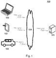
- the server 105 may be a server providing various services, such as a back-end server providing support for the terminal devices 101, 102, and 103.
- the back-end server may process, e.g., analyze, data such as received current positioning information, and return the processing result (e.g., update information of a positioning error threshold) to the terminal devices.
- terminal devices network, and server in Fig. 1 are merely illustrative. Any number of terminal devices, networks, and servers may be provided based on actual requirements.
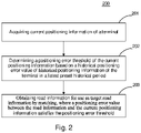
- Step 201 acquiring current positioning information of the terminal.
- positioning information of the terminal is position information of the terminal obtained through positioning by a module (such as a GPS module or a Beidou module) that has a positioning function on the terminal.
- a module such as a GPS module or a Beidou module
- Step 202 determining a positioning error threshold of the current positioning information based on a historical positioning error value of historical positioning information of the terminal in a latest preset historical period.
- the executing body may determine a positioning error threshold of the positioning information based on a historical positioning error value of historical positioning information of the terminal.
- the positioning error threshold here refers to a threshold defined for a value of positioning information deviating from a traveling road (a road network or a driving route). If the value of the positioning information deviating from a certain road exceeds the threshold, the road cannot be bound to the terminal.
- the executing body may use an error value within the latest preset historical period to determine the historical positioning error value, where the error value may specifically be a value such as a variance, a standard deviation, and an average value.
- the error value and the positioning error threshold e.g., the positioning error value, and the historical positioning error value
- the error value and the positioning error threshold may be obtained by wave filtering.
- the executing body may determine errors between positioning information and a traveling route within the latest historical 30S, calculate a standard deviation of these errors, and use the obtained variance of the errors as the historical positioning error value.
- the error value may include at least one value indicating an error between the road information and the positioning information.
- the error value may include a distance of projecting the positioning information onto the road information.
- an original value of the historical positioning error value may be provided by a server.
- the historical positioning error values corresponding to various machine types may be identical.
- the executing body may determine the positioning error threshold of the current positioning information based on the historical positioning error value by various approaches. For example, the positioning error threshold of the current positioning information is determined jointly based on the historical positioning error value and an existing positioning error threshold. For example, if the historical positioning error value is smaller than the existing positioning error threshold, the existing positioning error value is increased to obtain the positioning error threshold of the current positioning information, where the positioning error threshold is greater than the historical error threshold. If the historical positioning error value is greater than the existing positioning error threshold, the existing positioning error value is decreased.
- the executing body may input a current road type and the current positioning information into a preset model to obtain the positioning error threshold outputted from the preset model. The preset model may predict the positioning error threshold based on the current road type and the current positioning information.
- Step 203 obtaining road information for use as target road information by matching, wherein a positioning error value between the road information and the current positioning information satisfies the positioning error threshold, and the road information includes at least one of: a road network unit, a driving route unit, or the current positioning information.
- the executing body may obtain the target road information for the current positioning information based on the positioning error threshold, and the positioning error value between the target road information and the current positioning information satisfies the positioning error threshold.
- the road information here may include at least one of: a unit of a road network, a unit of a driving route obtained by navigation, or the current positioning information.
- the unit of the driving route refers to a road section in the driving route
- the unit of the road network refers to a road section in the road network (i.e., a road section in a road of the road network).
- the executing body may acquire a predetermined value determination condition between the positioning error value and the positioning error threshold, i.e., a condition for determining whether the positioning error value satisfies the positioning error threshold.
- a condition for determining whether the positioning error value satisfies the positioning error threshold may be that the positioning error value is smaller than the positioning error threshold, and then the positioning error value satisfies the positioning error threshold, or the condition may be that the positioning error value is greater than the positioning error threshold, and then the positioning error value satisfies the positioning error threshold.
- the positioning error value is an error value corresponding to the current positioning information.
- the positioning error threshold is a threshold set for the positioning error value.
- the method provided in the above embodiments of the present disclosure can determine the positioning error threshold in real time, thereby matching more accurate road information based on the latest positioning information error.
- the executing body may acquire the current road type of the terminal, and may determine the positioning error threshold of the current positioning information based on the historical positioning error value and the current road type.
- the current road type refers to a type of a road (i.e., a road section) on which the terminal is located.
- the current road type may be acquired by the executing body in various ways, for example, by sending a road type request to the server, and receiving the current road type returned from the server.
- the road type may be preset various road types.
- the road type may be a tunnel, a ring road, and the like. A road curvature of the tunnel is relatively small, and a road curvature of the ring road is large.
- These implementations may use a road type corresponding to the previous road matching cycle as the current road type, thereby improving the accuracy of the current road type as far as possible.
- Fig. 3 is a schematic diagram of an application scenario of the method for determining road information according to the present embodiment.
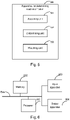
- an executing body 301 acquires current positioning information 302 of a terminal.
- the executing body 301 determines a positioning error threshold 304 of the current positioning information 302 based on a historical positioning error value 303 of the positioning information of the terminal in a latest preset historical period.
- the executing body 301 obtains road information or use as target road information 305 by matching, wherein a positioning error value between the road information and the current positioning information 302 satisfies the positioning error threshold 304, and the road information includes at least one of: a road network unit, a driving route unit, or the current positioning information.
- the historical positioning error value includes a historical error variance
- the method may include the following steps:
- Step 401 acquiring current positioning information of the terminal.
- the executing body may determine a positioning error threshold of the positioning information based on a historical positioning error value of historical positioning information of the terminal.
- the positioning error threshold here refers to a threshold defined for a value of positioning information deviating from a traveling road (a road network or a driving route).
- the executing body may determine at least two candidate road information of the terminal based on the current positioning information. That is, a terminal device first performs rough matching on the road information, and obtains at least two matching results.
- the executing body may perform the preset processing on the distance error and the angle error.
- the executing body may acquire a weight of the distance error obtained by the preset processing and a weight of the angle error obtained by the preset processing, weight the distance error obtained by the preset processing and weight the angle error obtained by the preset processing, and use the weighting results as the road binding confidence.
- the executing body may obtain the target road information from the at least two candidate road information by matching.
- the target road information is the road information with the road binding confidence reaching the confidence threshold.
- the positioning error threshold further includes a distance error threshold and an angle error threshold; and the obtaining the second road information for use as the target road information by matching, wherein the road binding confidence reaches the confidence threshold includes: obtaining candidate road information by matching, wherein for the candidate road information, a normalized distance error reaches the distance error threshold, a normalized angle error reaches the angle error threshold, and a road binding confidence reaches the confidence threshold, and using road information corresponding to the candidate road information as the target road information.
- the candidate road information matched by the executing body has the normalized distance error reaching the distance error threshold, the normalized angle error reaching the angle error threshold, and the road binding confidence reaching the confidence threshold.
- These alternative implementations may determine road information with a small distance error, a small angle error, and a small weighting result of the distance error and the angle error, thereby effectively improving the accuracy of the determined road.
- the obtaining the road information by matching, wherein the positioning error value between the road information and the current positioning information satisfies the positioning error threshold may include: uploading a threshold updating request to a server, and receiving update information about the positioning error threshold returned from the server; and updating the positioning error threshold using the update information to obtain an updated positioning error threshold, and obtaining the road information by matching, wherein the positioning error value between the road information and the current positioning information satisfies the updated positioning error threshold.
- These implementations may update the threshold using the server, thereby further improving the accuracy of the threshold.
- the threshold updating request includes a trajectory of the terminal and the target road information
- the uploading the threshold updating request to the server may include: uploading the threshold updating request to the server, where the server determines, based on the trajectory, the road information of the terminal as reference road information, and generates the update information about the positioning error threshold based on the reference road information and the target road information.
- the executing body may upload the trajectory of the terminal and the target road information to the server, such that the server may match the terminal with a piece of road information, i.e., the reference road information, and generate the update information based on the reference road information and the target road information.
- a piece of road information i.e., the reference road information
- the executing body may generate the update information based on the reference road information and the target road information by various approaches. For example, the executing body may compare the target road information with the reference road information, and directly use a difference value obtained from the comparison as the update information. Alternatively, the executing body may perform preset processing on the difference value, and use the result of the preset processing as the update information.
- the preset processing here may be, e.g., inputting the difference value into a preset equation, or multiplying the difference value by a preset coefficient.
- the executing body may alternatively input the reference road information and the target road information into a trained model, and obtain update information outputted from the model. The model may predict the update information based on the reference road and the target road information.
- the reference road information and the target road information may exist respectively in the forms of a plurality of points, where if there are some unmatching points between the reference road information and the target road information on the terminal, update information may be generated based on these unmatching points.
- These alternative implementations may determine the road information based on the trajectory of the terminal.
- the trajectory eliminates a local error of the road information determined by the terminal in real time, and determines more accurate road information relative to the terminal, thereby accurately correcting the positioning error threshold based on the update information.
- the method further includes: generating a new positioning error threshold based on the following parameters of a current road matching cycle: a positioning error threshold determined by the terminal, a confidence of the positioning error threshold, the number of iterations of the positioning error threshold at the terminal, a reference positioning error threshold determined by the server, a confidence of the reference positioning error threshold, and the number of iterations of the reference positioning error threshold at the server.
- the executing body may generate a new positioning error threshold based on the above parameters, and correct the positioning error threshold using the new positioning error threshold.
- the corrected positioning error threshold is the new positioning error threshold.
- the executing body may generate the new positioning error threshold by various approaches, for example, by inputting the above parameters into a pre-trained model, and obtaining a new positioning error threshold outputted from the model.
- the model may predict the new positioning error threshold.
- the positioning error threshold determined by the terminal may be set as A1 (for example, the positioning error threshold determined in step 202), the confidence of the positioning error threshold may be set as X1, and the number of iterations of the positioning error threshold at the terminal may be set as N1.
- the reference positioning error threshold determined by the server is A2
- a confidence of the reference positioning error threshold is X2
- the number of iterations of the reference positioning error threshold at the server is N2.
- the new positioning error threshold may be expressed as: N 1 * A 1 * X 1 + N 2 * A 2 * X 2 / N 1 * X 1 + N 2 * X 2 , where "*" is multiplication
- the confidence refers to a confidence degree of the positioning error threshold. With the increase of the number of iterations, the confidence increases.
- the iteration refers to the number of times of determining the positioning error threshold on an electronic device, and the determining the positioning error threshold will generally be iterated on the basis of the existing positioning error threshold.
- These implementations may correct the positioning error threshold of the terminal using the reference positioning error threshold of the server, thereby improving the accuracy of the positioning error threshold.
- the server may receive the positioning error threshold determined by the terminal, and then determine the reference positioning error threshold.
- the reference positioning error threshold may be determined by various approaches, for example, by inputting these parameters into a trained model, and obtaining the reference positioning error threshold outputted from the model.
- the model may predict the reference positioning error threshold.
- the road information is a road network unit, a driving route unit, or positioning information; and the obtaining the road information by the matching, where the positioning error value between the road information and the current positioning information satisfies the positioning error threshold includes: matching the current positioning information with the driving route; using, in response to obtaining a matching driving route, the matching driving route as the target road information; and matching, in response to not obtaining the matching driving route, the positioning information with the road network; using, in response to obtaining a matching road network, the matching road network as the target road information; and using, in response to not obtaining the matching road network, the current positioning information as the target road information.
- the executing body may first match the driving route unit. If the driving route unit is matched, i.e., it is determined that a driving route unit exists in an area where the current positioning information is located, where a positioning error value between the driving route unit and the current positioning information reaches the position error threshold, the executing body may use the driving route unit as the target road information. If no driving route unit is matched, i.e., a positioning error value between any driving route unit in the area where the current positioning information is located and the current positioning information does not reach the positioning error threshold, the executing body may match the road network unit.
- the executing body may use the road network unit as the target road information. If no road network unit is matched, i.e., a positioning error value between any road network unit in the area where the current positioning information is located and the current positioning information does not reach the positioning error threshold, the executing body may directly use the above current positioning information as the target road information.
- an embodiment of the present disclosure provides an apparatus for determining road information.
- the embodiment of the apparatus corresponds to the embodiment of the method shown in Fig. 2 .
- the embodiment of the apparatus may further include features or effects identical or corresponding to the embodiment of the method shown in Fig. 2 .
- the apparatus may be specifically applied to various electronic devices.
- the threshold updating request includes a trajectory of the terminal and the target road information; and the matching unit is further configured to execute the uploading the threshold updating request to the server by: uploading the threshold updating request to the server, where the server determines, based on the trajectory, the road information of the terminal as reference road information, and generates the update information about the positioning error threshold based on the reference road information and the target road information.
- the apparatus further includes: a generating unit configured to, after the determining the positioning error threshold of the current positioning information, generate a new positioning error threshold based on the following parameters of a current road matching cycle: a positioning error threshold determined by the terminal, a confidence of the positioning error threshold, the number of iterations of the positioning error threshold at the terminal, a reference positioning error threshold determined by the server, a confidence of the reference positioning error threshold, and the number of iterations of the positioning error threshold at the server.
- a generating unit configured to, after the determining the positioning error threshold of the current positioning information, generate a new positioning error threshold based on the following parameters of a current road matching cycle: a positioning error threshold determined by the terminal, a confidence of the positioning error threshold, the number of iterations of the positioning error threshold at the terminal, a reference positioning error threshold determined by the server, a confidence of the reference positioning error threshold, and the number of iterations of the positioning error threshold at the server.
- the historical positioning error value includes a distance error variance and an angle error variance
- the apparatus further includes: a weight determining unit configured to determine, for the at least two candidate road information, a weight of the distance error and a weight of the angle error based on the distance error variance and the angle error variance.
- the positioning error threshold further includes a distance error threshold and an angle error threshold; and the matching unit is further configured to execute the obtaining the second road information for use as the target road information by matching, wherein the road binding confidence reaches the confidence threshold by: obtaining candidate road information by matching, wherein for the candidate road information, the distance error obtained by the preset processing reaches the distance error threshold, an angle error obtained by the preset processing reaches the angle error threshold, and a road binding confidence reaches the confidence threshold, and using road information corresponding to the candidate road information as the target road information.
- the determining unit is further configured to execute the determining the positioning error threshold of the current positioning information based on the historical positioning error value of the historical positioning information of the terminal in the latest preset historical period by: acquiring a current road type of the terminal; and determining the positioning error threshold of the current positioning information based on the historical positioning error value and the current road type.
- the electronic device includes: one or more processors 601, a memory 602, and interfaces for connecting various components, including a high-speed interface and a low-speed interface.
- the various components are interconnected using different buses, and may be mounted on a common motherboard or in other manners as required.
- the processor may process instructions for execution within the electronic device, including instructions stored in the memory or on the memory to display graphical information for a GUI on an external input/output apparatus (e.g., a display device coupled to an interface).
- a plurality of processors and/or a plurality of buses may be used, as appropriate, along with a plurality of memories and a plurality of memories.
- a plurality of electronic devices may be connected, with each device providing portions of necessary operations (e.g., as a server array, a group of blade servers, or a multi-processor system).
- a processor 601 is taken as an example.
- the memory 602 is a non-transient computer readable storage medium provided in the present disclosure.
- the memory stores instructions executable by at least one processor, such that the at least one processor executes the method for determining road information provided in the present disclosure.
- the non-transient computer readable storage medium of the present disclosure stores computer instructions. The computer instructions are used for causing a computer to execute the method for determining road information provided in the present disclosure.
- the memory 602 may be configured to store non-transient software programs, non-transient computer executable programs and modules, such as the program instructions/modules (e.g., the acquiring unit 501, the determining unit 502, and the matching unit 503 shown in Fig. 5 ) corresponding to the method for determining road information in some embodiments of the present disclosure.
- the processor 601 runs non-transient software programs, instructions, and modules stored in the memory 602, so as to execute various function applications and data processing of a server, i.e., implementing the method for determining road information in the above embodiments of the method.
- the electronic device of the method for determining road information may further include: an input apparatus 603 and an output apparatus 604.
- the processor 601, the memory 602, the input apparatus 603, and the output apparatus 604 may be connected through a bus or in other manners. Bus connection is taken as an example in Fig. 6 .
- the systems and technologies described herein may be implemented in a computing system that includes a back-end component (e.g., as a data server), or a computing system that includes a middleware component (e.g., an application server), or a computing system that includes a front-end component (e.g., a user computer with a graphical user interface or a web browser through which the user can interact with an implementation of the systems and technologies described herein), or a computing system that includes any combination of such a back-end component, such a middleware component, or such a front-end component.
- the components of the system may be interconnected by digital data communication (e.g., a communication network) in any form or medium. Examples of the communication network include: a local area network (LAN), a wide area network (WAN), and the Internet.
- the present disclosure further provides a computer readable medium.
- the computer readable medium may be included in the apparatus described in the above embodiments, or a stand-alone computer readable medium without being assembled into the apparatus.
- the computer readable medium carries one or more programs.
Landscapes
- Engineering & Computer Science (AREA)
- Radar, Positioning & Navigation (AREA)
- Remote Sensing (AREA)
- Physics & Mathematics (AREA)
- General Physics & Mathematics (AREA)
- Automation & Control Theory (AREA)
- Computer Networks & Wireless Communication (AREA)
- Chemical & Material Sciences (AREA)
- Analytical Chemistry (AREA)
- Navigation (AREA)
- Information Retrieval, Db Structures And Fs Structures Therefor (AREA)
- Instructional Devices (AREA)
Applications Claiming Priority (1)
| Application Number | Priority Date | Filing Date | Title |
|---|---|---|---|
| CN202110640562.2A CN113380031B (zh) | 2021-06-09 | 2021-06-09 | 道路信息的确定方法和装置 |
Publications (3)
| Publication Number | Publication Date |
|---|---|
| EP4030139A2 true EP4030139A2 (fr) | 2022-07-20 |
| EP4030139A3 EP4030139A3 (fr) | 2022-12-21 |
| EP4030139B1 EP4030139B1 (fr) | 2024-07-24 |
Family
ID=77572966
Family Applications (1)
| Application Number | Title | Priority Date | Filing Date |
|---|---|---|---|
| EP22176768.4A Active EP4030139B1 (fr) | 2021-06-09 | 2022-06-01 | Procede et appareil pour determiner des informations routieres |
Country Status (5)
| Country | Link |
|---|---|
| US (1) | US20220291002A1 (fr) |
| EP (1) | EP4030139B1 (fr) |
| JP (1) | JP7372377B2 (fr) |
| KR (1) | KR102783761B1 (fr) |
| CN (1) | CN113380031B (fr) |
Families Citing this family (1)
| Publication number | Priority date | Publication date | Assignee | Title |
|---|---|---|---|---|
| CN116026352A (zh) * | 2023-02-10 | 2023-04-28 | 腾讯科技(深圳)有限公司 | 定位信号的处理方法、装置、介质及电子设备 |
Family Cites Families (20)
| Publication number | Priority date | Publication date | Assignee | Title |
|---|---|---|---|---|
| US5283575A (en) * | 1991-11-08 | 1994-02-01 | Zexel Corporation | System and method for locating a travelling vehicle |
| WO1998059214A1 (fr) * | 1997-06-20 | 1998-12-30 | Mitsubishi Denki Kabushiki Kaisha | Dispositif d'affichage d'informations cartographiques |
| US6680694B1 (en) * | 1997-08-19 | 2004-01-20 | Siemens Vdo Automotive Corporation | Vehicle information system |
| JP3960469B2 (ja) * | 2002-04-26 | 2007-08-15 | パイオニア株式会社 | ナビゲーションシステム及びナビゲーション装置 |
| KR20080101242A (ko) * | 2007-05-16 | 2008-11-21 | 팅크웨어(주) | 측위 오차를 이용한 내비게이션 맵매칭 방법 및 시스템 |
| US20110241935A1 (en) * | 2009-03-23 | 2011-10-06 | Srdjan Miocinovic | Method and apparatus for improving gps receiver accuracy using an embedded map database |
| JP4934167B2 (ja) * | 2009-06-18 | 2012-05-16 | クラリオン株式会社 | 位置検出装置および位置検出プログラム |
| CN102313556B (zh) * | 2010-07-01 | 2014-04-02 | 北京四维图新科技股份有限公司 | 环岛上的路径匹配的方法及装置 |
| CN104422459B (zh) * | 2013-09-06 | 2017-07-18 | 上海博泰悦臻电子设备制造有限公司 | 一种确定车辆位置的方法及装置、导航方法和导航系统 |
| JP6229523B2 (ja) * | 2014-02-12 | 2017-11-15 | 株式会社デンソー | 自車走行位置特定装置及び自車走行位置特定プログラム |
| US20150247931A1 (en) * | 2014-02-28 | 2015-09-03 | Hemisphere Gnss Inc. | Locally enhanced gnss wide-area augmentation system |
| JP2016138816A (ja) * | 2015-01-28 | 2016-08-04 | アルパイン株式会社 | ナビゲーション装置及びコンピュータプログラム |
| CN106969764B (zh) * | 2016-01-13 | 2020-05-01 | 北京四维图新科技股份有限公司 | 一种道路匹配方法、装置及车载地图采集系统 |
| CN107228677B (zh) * | 2016-03-23 | 2019-03-26 | 腾讯科技(深圳)有限公司 | 偏航识别方法和装置 |
| JP6805704B2 (ja) | 2016-10-11 | 2020-12-23 | 日産自動車株式会社 | 経路選択方法及び経路選択装置 |
| JP6870507B2 (ja) * | 2017-07-07 | 2021-05-12 | 株式会社デンソー | 測位装置 |
| CN111381263B (zh) * | 2018-12-28 | 2022-09-13 | 沈阳美行科技股份有限公司 | 定位方法、装置、电子设备和存储介质 |
| EP3693702A1 (fr) * | 2019-02-05 | 2020-08-12 | Visteon Global Technologies, Inc. | Procédé de localisation d'un véhicule |
| CN110031011B (zh) * | 2019-04-17 | 2021-05-11 | 首都师范大学 | 集成时空邻近与改进权重圆的车载实时地图匹配计算方法 |
| US20220299341A1 (en) * | 2021-03-19 | 2022-09-22 | Here Global B.V. | Method, apparatus, and system for providing route-identification for unordered line data |
-
2021
- 2021-06-09 CN CN202110640562.2A patent/CN113380031B/zh active Active
-
2022
- 2022-03-28 JP JP2022051653A patent/JP7372377B2/ja active Active
- 2022-04-18 KR KR1020220047839A patent/KR102783761B1/ko active Active
- 2022-06-01 EP EP22176768.4A patent/EP4030139B1/fr active Active
- 2022-06-01 US US17/830,029 patent/US20220291002A1/en active Pending
Also Published As
| Publication number | Publication date |
|---|---|
| JP7372377B2 (ja) | 2023-10-31 |
| CN113380031B (zh) | 2023-04-25 |
| KR20220056839A (ko) | 2022-05-06 |
| JP2022091887A (ja) | 2022-06-21 |
| KR102783761B1 (ko) | 2025-03-18 |
| EP4030139B1 (fr) | 2024-07-24 |
| US20220291002A1 (en) | 2022-09-15 |
| CN113380031A (zh) | 2021-09-10 |
| EP4030139A3 (fr) | 2022-12-21 |
Similar Documents
| Publication | Publication Date | Title |
|---|---|---|
| EP3961489B1 (fr) | Procédé et appareil permettant d'identifier des mises à jour de route, dispositif et support de stockage informatique | |
| US11626013B2 (en) | Traffic data analysis method, electronic device, vehicle and storage medium | |
| EP3842745B1 (fr) | Procede et appareil pour mettre a jour un nuage de points | |
| US12367373B2 (en) | Controlling robots using entropy constraints | |
| US11748895B2 (en) | Method and apparatus for processing video frame | |
| CN111563593B (zh) | 神经网络模型的训练方法和装置 | |
| US11486713B2 (en) | Method and apparatus for positioning autonomous vehicle | |
| EP3816999B1 (fr) | Détermination de la direction d'arrivée de la parole basée sur un réseau neuronal | |
| CN112699765B (zh) | 评估视觉定位算法的方法、装置、电子设备及存储介质 | |
| CN110706147B (zh) | 图像处理的环境确定方法、装置、电子设备和存储介质 | |
| EP3846050A2 (fr) | Méthode, appareil, dispositif, support de stockage et produit de programme informatique pour l'expansion des données | |
| KR20230008005A (ko) | 정보를 확정하기 위한 방법 및 장치 | |
| CN113670295B (zh) | 数据处理方法、装置、电子设备及可读存储介质 | |
| EP3958219A2 (fr) | Procédé et appareil de génération de modèle de classification des dégradations de plaques d'immatriculation, procédé et appareil de classification des dégradations de plaques d'immatriculation, dispositif électronique, support de stockage et produit-programme informatique | |
| US9953264B2 (en) | Smart process management | |
| EP4030139A2 (fr) | Procede et appareil pour determiner des informations routieres | |
| CN114443679A (zh) | 一种地图数据更新方法、装置、设备以及存储介质 | |
| CN111260722B (zh) | 车辆定位方法、设备及存储介质 | |
| CN118245341B (zh) | 业务模型的切换方法、装置、电子设备和计算机可读介质 | |
| CN116358530B (zh) | 姿态信息估计方法、装置、存储介质及设备 | |
| CN110370267B (zh) | 用于生成模型的方法和装置 | |
| CN116386026B (zh) | 点云3d检测模型的训练方法和点云检测方法 | |
| CN112926629B (zh) | 超参数确定方法、装置、深度强化学习框架、介质及设备 | |
| CN114844889A (zh) | 视频处理模型的更新方法、装置、电子设备及存储介质 | |
| US20250118091A1 (en) | Method for training map update model, method for updating lane-level map and method for navigating |
Legal Events
| Date | Code | Title | Description |
|---|---|---|---|
| PUAI | Public reference made under article 153(3) epc to a published international application that has entered the european phase |
Free format text: ORIGINAL CODE: 0009012 |
|
| STAA | Information on the status of an ep patent application or granted ep patent |
Free format text: STATUS: REQUEST FOR EXAMINATION WAS MADE |
|
| 17P | Request for examination filed |
Effective date: 20220601 |
|
| AK | Designated contracting states |
Kind code of ref document: A2 Designated state(s): AL AT BE BG CH CY CZ DE DK EE ES FI FR GB GR HR HU IE IS IT LI LT LU LV MC MK MT NL NO PL PT RO RS SE SI SK SM TR |
|
| PUAL | Search report despatched |
Free format text: ORIGINAL CODE: 0009013 |
|
| AK | Designated contracting states |
Kind code of ref document: A3 Designated state(s): AL AT BE BG CH CY CZ DE DK EE ES FI FR GB GR HR HU IE IS IT LI LT LU LV MC MK MT NL NO PL PT RO RS SE SI SK SM TR |
|
| RIC1 | Information provided on ipc code assigned before grant |
Ipc: G01C 21/30 20060101AFI20221117BHEP |
|
| GRAP | Despatch of communication of intention to grant a patent |
Free format text: ORIGINAL CODE: EPIDOSNIGR1 |
|
| STAA | Information on the status of an ep patent application or granted ep patent |
Free format text: STATUS: GRANT OF PATENT IS INTENDED |
|
| INTG | Intention to grant announced |
Effective date: 20240213 |
|
| GRAS | Grant fee paid |
Free format text: ORIGINAL CODE: EPIDOSNIGR3 |
|
| GRAA | (expected) grant |
Free format text: ORIGINAL CODE: 0009210 |
|
| STAA | Information on the status of an ep patent application or granted ep patent |
Free format text: STATUS: THE PATENT HAS BEEN GRANTED |
|
| AK | Designated contracting states |
Kind code of ref document: B1 Designated state(s): AL AT BE BG CH CY CZ DE DK EE ES FI FR GB GR HR HU IE IS IT LI LT LU LV MC MK MT NL NO PL PT RO RS SE SI SK SM TR |
|
| REG | Reference to a national code |
Ref country code: GB Ref legal event code: FG4D |
|
| REG | Reference to a national code |
Ref country code: CH Ref legal event code: EP |
|
| P01 | Opt-out of the competence of the unified patent court (upc) registered |
Free format text: CASE NUMBER: APP_40582/2024 Effective date: 20240709 |
|
| REG | Reference to a national code |
Ref country code: IE Ref legal event code: FG4D Ref country code: DE Ref legal event code: R096 Ref document number: 602022004736 Country of ref document: DE |
|
| REG | Reference to a national code |
Ref country code: LT Ref legal event code: MG9D |
|
| REG | Reference to a national code |
Ref country code: NL Ref legal event code: MP Effective date: 20240724 |
|
| PG25 | Lapsed in a contracting state [announced via postgrant information from national office to epo] |
Ref country code: PT Free format text: LAPSE BECAUSE OF FAILURE TO SUBMIT A TRANSLATION OF THE DESCRIPTION OR TO PAY THE FEE WITHIN THE PRESCRIBED TIME-LIMIT Effective date: 20241125 |
|
| REG | Reference to a national code |
Ref country code: AT Ref legal event code: MK05 Ref document number: 1706672 Country of ref document: AT Kind code of ref document: T Effective date: 20240724 |
|
| PG25 | Lapsed in a contracting state [announced via postgrant information from national office to epo] |
Ref country code: NL Free format text: LAPSE BECAUSE OF FAILURE TO SUBMIT A TRANSLATION OF THE DESCRIPTION OR TO PAY THE FEE WITHIN THE PRESCRIBED TIME-LIMIT Effective date: 20240724 |
|
| PG25 | Lapsed in a contracting state [announced via postgrant information from national office to epo] |
Ref country code: PT Free format text: LAPSE BECAUSE OF FAILURE TO SUBMIT A TRANSLATION OF THE DESCRIPTION OR TO PAY THE FEE WITHIN THE PRESCRIBED TIME-LIMIT Effective date: 20241125 Ref country code: NL Free format text: LAPSE BECAUSE OF FAILURE TO SUBMIT A TRANSLATION OF THE DESCRIPTION OR TO PAY THE FEE WITHIN THE PRESCRIBED TIME-LIMIT Effective date: 20240724 |
|
| PG25 | Lapsed in a contracting state [announced via postgrant information from national office to epo] |
Ref country code: NO Free format text: LAPSE BECAUSE OF FAILURE TO SUBMIT A TRANSLATION OF THE DESCRIPTION OR TO PAY THE FEE WITHIN THE PRESCRIBED TIME-LIMIT Effective date: 20241024 |
|
| PG25 | Lapsed in a contracting state [announced via postgrant information from national office to epo] |
Ref country code: GR Free format text: LAPSE BECAUSE OF FAILURE TO SUBMIT A TRANSLATION OF THE DESCRIPTION OR TO PAY THE FEE WITHIN THE PRESCRIBED TIME-LIMIT Effective date: 20241025 Ref country code: PL Free format text: LAPSE BECAUSE OF FAILURE TO SUBMIT A TRANSLATION OF THE DESCRIPTION OR TO PAY THE FEE WITHIN THE PRESCRIBED TIME-LIMIT Effective date: 20240724 Ref country code: FI Free format text: LAPSE BECAUSE OF FAILURE TO SUBMIT A TRANSLATION OF THE DESCRIPTION OR TO PAY THE FEE WITHIN THE PRESCRIBED TIME-LIMIT Effective date: 20240724 |
|
| PG25 | Lapsed in a contracting state [announced via postgrant information from national office to epo] |
Ref country code: BG Free format text: LAPSE BECAUSE OF FAILURE TO SUBMIT A TRANSLATION OF THE DESCRIPTION OR TO PAY THE FEE WITHIN THE PRESCRIBED TIME-LIMIT Effective date: 20240724 |
|
| PG25 | Lapsed in a contracting state [announced via postgrant information from national office to epo] |
Ref country code: LV Free format text: LAPSE BECAUSE OF FAILURE TO SUBMIT A TRANSLATION OF THE DESCRIPTION OR TO PAY THE FEE WITHIN THE PRESCRIBED TIME-LIMIT Effective date: 20240724 |
|
| PG25 | Lapsed in a contracting state [announced via postgrant information from national office to epo] |
Ref country code: IS Free format text: LAPSE BECAUSE OF FAILURE TO SUBMIT A TRANSLATION OF THE DESCRIPTION OR TO PAY THE FEE WITHIN THE PRESCRIBED TIME-LIMIT Effective date: 20241124 Ref country code: AT Free format text: LAPSE BECAUSE OF FAILURE TO SUBMIT A TRANSLATION OF THE DESCRIPTION OR TO PAY THE FEE WITHIN THE PRESCRIBED TIME-LIMIT Effective date: 20240724 |
|
| PG25 | Lapsed in a contracting state [announced via postgrant information from national office to epo] |
Ref country code: HR Free format text: LAPSE BECAUSE OF FAILURE TO SUBMIT A TRANSLATION OF THE DESCRIPTION OR TO PAY THE FEE WITHIN THE PRESCRIBED TIME-LIMIT Effective date: 20240724 |
|
| PG25 | Lapsed in a contracting state [announced via postgrant information from national office to epo] |
Ref country code: ES Free format text: LAPSE BECAUSE OF FAILURE TO SUBMIT A TRANSLATION OF THE DESCRIPTION OR TO PAY THE FEE WITHIN THE PRESCRIBED TIME-LIMIT Effective date: 20240724 Ref country code: RS Free format text: LAPSE BECAUSE OF FAILURE TO SUBMIT A TRANSLATION OF THE DESCRIPTION OR TO PAY THE FEE WITHIN THE PRESCRIBED TIME-LIMIT Effective date: 20241024 |
|
| PG25 | Lapsed in a contracting state [announced via postgrant information from national office to epo] |
Ref country code: RS Free format text: LAPSE BECAUSE OF FAILURE TO SUBMIT A TRANSLATION OF THE DESCRIPTION OR TO PAY THE FEE WITHIN THE PRESCRIBED TIME-LIMIT Effective date: 20241024 Ref country code: PL Free format text: LAPSE BECAUSE OF FAILURE TO SUBMIT A TRANSLATION OF THE DESCRIPTION OR TO PAY THE FEE WITHIN THE PRESCRIBED TIME-LIMIT Effective date: 20240724 Ref country code: NO Free format text: LAPSE BECAUSE OF FAILURE TO SUBMIT A TRANSLATION OF THE DESCRIPTION OR TO PAY THE FEE WITHIN THE PRESCRIBED TIME-LIMIT Effective date: 20241024 Ref country code: LV Free format text: LAPSE BECAUSE OF FAILURE TO SUBMIT A TRANSLATION OF THE DESCRIPTION OR TO PAY THE FEE WITHIN THE PRESCRIBED TIME-LIMIT Effective date: 20240724 Ref country code: IS Free format text: LAPSE BECAUSE OF FAILURE TO SUBMIT A TRANSLATION OF THE DESCRIPTION OR TO PAY THE FEE WITHIN THE PRESCRIBED TIME-LIMIT Effective date: 20241124 Ref country code: HR Free format text: LAPSE BECAUSE OF FAILURE TO SUBMIT A TRANSLATION OF THE DESCRIPTION OR TO PAY THE FEE WITHIN THE PRESCRIBED TIME-LIMIT Effective date: 20240724 Ref country code: GR Free format text: LAPSE BECAUSE OF FAILURE TO SUBMIT A TRANSLATION OF THE DESCRIPTION OR TO PAY THE FEE WITHIN THE PRESCRIBED TIME-LIMIT Effective date: 20241025 Ref country code: FI Free format text: LAPSE BECAUSE OF FAILURE TO SUBMIT A TRANSLATION OF THE DESCRIPTION OR TO PAY THE FEE WITHIN THE PRESCRIBED TIME-LIMIT Effective date: 20240724 Ref country code: ES Free format text: LAPSE BECAUSE OF FAILURE TO SUBMIT A TRANSLATION OF THE DESCRIPTION OR TO PAY THE FEE WITHIN THE PRESCRIBED TIME-LIMIT Effective date: 20240724 Ref country code: BG Free format text: LAPSE BECAUSE OF FAILURE TO SUBMIT A TRANSLATION OF THE DESCRIPTION OR TO PAY THE FEE WITHIN THE PRESCRIBED TIME-LIMIT Effective date: 20240724 Ref country code: AT Free format text: LAPSE BECAUSE OF FAILURE TO SUBMIT A TRANSLATION OF THE DESCRIPTION OR TO PAY THE FEE WITHIN THE PRESCRIBED TIME-LIMIT Effective date: 20240724 |
|
| PG25 | Lapsed in a contracting state [announced via postgrant information from national office to epo] |
Ref country code: SM Free format text: LAPSE BECAUSE OF FAILURE TO SUBMIT A TRANSLATION OF THE DESCRIPTION OR TO PAY THE FEE WITHIN THE PRESCRIBED TIME-LIMIT Effective date: 20240724 Ref country code: RO Free format text: LAPSE BECAUSE OF FAILURE TO SUBMIT A TRANSLATION OF THE DESCRIPTION OR TO PAY THE FEE WITHIN THE PRESCRIBED TIME-LIMIT Effective date: 20240724 Ref country code: DK Free format text: LAPSE BECAUSE OF FAILURE TO SUBMIT A TRANSLATION OF THE DESCRIPTION OR TO PAY THE FEE WITHIN THE PRESCRIBED TIME-LIMIT Effective date: 20240724 |
|
| PG25 | Lapsed in a contracting state [announced via postgrant information from national office to epo] |
Ref country code: EE Free format text: LAPSE BECAUSE OF FAILURE TO SUBMIT A TRANSLATION OF THE DESCRIPTION OR TO PAY THE FEE WITHIN THE PRESCRIBED TIME-LIMIT Effective date: 20240724 |
|
| PG25 | Lapsed in a contracting state [announced via postgrant information from national office to epo] |
Ref country code: CZ Free format text: LAPSE BECAUSE OF FAILURE TO SUBMIT A TRANSLATION OF THE DESCRIPTION OR TO PAY THE FEE WITHIN THE PRESCRIBED TIME-LIMIT Effective date: 20240724 |
|
| REG | Reference to a national code |
Ref country code: DE Ref legal event code: R097 Ref document number: 602022004736 Country of ref document: DE |
|
| PG25 | Lapsed in a contracting state [announced via postgrant information from national office to epo] |
Ref country code: SK Free format text: LAPSE BECAUSE OF FAILURE TO SUBMIT A TRANSLATION OF THE DESCRIPTION OR TO PAY THE FEE WITHIN THE PRESCRIBED TIME-LIMIT Effective date: 20240724 Ref country code: IT Free format text: LAPSE BECAUSE OF FAILURE TO SUBMIT A TRANSLATION OF THE DESCRIPTION OR TO PAY THE FEE WITHIN THE PRESCRIBED TIME-LIMIT Effective date: 20240724 |
|
| PLBE | No opposition filed within time limit |
Free format text: ORIGINAL CODE: 0009261 |
|
| STAA | Information on the status of an ep patent application or granted ep patent |
Free format text: STATUS: NO OPPOSITION FILED WITHIN TIME LIMIT |
|
| 26N | No opposition filed |
Effective date: 20250425 |
|
| PGFP | Annual fee paid to national office [announced via postgrant information from national office to epo] |
Ref country code: DE Payment date: 20250618 Year of fee payment: 4 |
|
| PGFP | Annual fee paid to national office [announced via postgrant information from national office to epo] |
Ref country code: FR Payment date: 20250612 Year of fee payment: 4 |
|
| PG25 | Lapsed in a contracting state [announced via postgrant information from national office to epo] |
Ref country code: SE Free format text: LAPSE BECAUSE OF FAILURE TO SUBMIT A TRANSLATION OF THE DESCRIPTION OR TO PAY THE FEE WITHIN THE PRESCRIBED TIME-LIMIT Effective date: 20240724 |
|
| REG | Reference to a national code |
Ref country code: CH Ref legal event code: H13 Free format text: ST27 STATUS EVENT CODE: U-0-0-H10-H13 (AS PROVIDED BY THE NATIONAL OFFICE) Effective date: 20260127 |
|
| PG25 | Lapsed in a contracting state [announced via postgrant information from national office to epo] |
Ref country code: MC Free format text: LAPSE BECAUSE OF FAILURE TO SUBMIT A TRANSLATION OF THE DESCRIPTION OR TO PAY THE FEE WITHIN THE PRESCRIBED TIME-LIMIT Effective date: 20240724 |
|
| PG25 | Lapsed in a contracting state [announced via postgrant information from national office to epo] |
Ref country code: LU Free format text: LAPSE BECAUSE OF NON-PAYMENT OF DUE FEES Effective date: 20250601 |
|
| REG | Reference to a national code |
Ref country code: BE Ref legal event code: MM Effective date: 20250630 |
|
| PG25 | Lapsed in a contracting state [announced via postgrant information from national office to epo] |
Ref country code: IE Free format text: LAPSE BECAUSE OF NON-PAYMENT OF DUE FEES Effective date: 20250601 |
|
| PG25 | Lapsed in a contracting state [announced via postgrant information from national office to epo] |
Ref country code: BE Free format text: LAPSE BECAUSE OF NON-PAYMENT OF DUE FEES Effective date: 20250630 |
|
| PG25 | Lapsed in a contracting state [announced via postgrant information from national office to epo] |
Ref country code: CH Free format text: LAPSE BECAUSE OF NON-PAYMENT OF DUE FEES Effective date: 20250630 |