EP4036610A1 - Procédé pour diriger un navire, système de navigation associé et procédé d'acquisition de données sismiques - Google Patents
Procédé pour diriger un navire, système de navigation associé et procédé d'acquisition de données sismiques Download PDFInfo
- Publication number
- EP4036610A1 EP4036610A1 EP21305119.6A EP21305119A EP4036610A1 EP 4036610 A1 EP4036610 A1 EP 4036610A1 EP 21305119 A EP21305119 A EP 21305119A EP 4036610 A1 EP4036610 A1 EP 4036610A1
- Authority
- EP
- European Patent Office
- Prior art keywords
- streamer
- vessel
- spread
- point
- given
- Prior art date
- Legal status (The legal status is an assumption and is not a legal conclusion. Google has not performed a legal analysis and makes no representation as to the accuracy of the status listed.)
- Withdrawn
Links
Images


Classifications
-
- G—PHYSICS
- G01—MEASURING; TESTING
- G01V—GEOPHYSICS; GRAVITATIONAL MEASUREMENTS; DETECTING MASSES OR OBJECTS; TAGS
- G01V1/00—Seismology; Seismic or acoustic prospecting or detecting
- G01V1/38—Seismology; Seismic or acoustic prospecting or detecting specially adapted for water-covered areas
- G01V1/3817—Positioning of seismic devices
- G01V1/3826—Positioning of seismic devices dynamic steering, e.g. by paravanes or birds
-
- B—PERFORMING OPERATIONS; TRANSPORTING
- B63—SHIPS OR OTHER WATERBORNE VESSELS; RELATED EQUIPMENT
- B63B—SHIPS OR OTHER WATERBORNE VESSELS; EQUIPMENT FOR SHIPPING
- B63B21/00—Tying-up; Shifting, towing, or pushing equipment; Anchoring
- B63B21/56—Towing or pushing equipment
- B63B21/66—Equipment specially adapted for towing underwater objects or vessels, e.g. fairings for tow-cables
-
- B—PERFORMING OPERATIONS; TRANSPORTING
- B63—SHIPS OR OTHER WATERBORNE VESSELS; RELATED EQUIPMENT
- B63B—SHIPS OR OTHER WATERBORNE VESSELS; EQUIPMENT FOR SHIPPING
- B63B79/00—Monitoring properties or operating parameters of vessels in operation
-
- B—PERFORMING OPERATIONS; TRANSPORTING
- B63—SHIPS OR OTHER WATERBORNE VESSELS; RELATED EQUIPMENT
- B63B—SHIPS OR OTHER WATERBORNE VESSELS; EQUIPMENT FOR SHIPPING
- B63B2211/00—Applications
- B63B2211/02—Oceanography
-
- G—PHYSICS
- G01—MEASURING; TESTING
- G01V—GEOPHYSICS; GRAVITATIONAL MEASUREMENTS; DETECTING MASSES OR OBJECTS; TAGS
- G01V2210/00—Details of seismic processing or analysis
- G01V2210/10—Aspects of acoustic signal generation or detection
- G01V2210/14—Signal detection
- G01V2210/142—Receiver location
- G01V2210/1423—Sea
Definitions
- Embodiments of the subject matter disclosed herein generally relate to marine surveys, in particular to marine seismic surveys.
- Seismic data acquisition and processing generate a profile (image) of the geophysical structure (subsurface) under the floor.
- seismic sources like “air guns”, “vibratory sources”, ”.
- the sensors are housed in cables, called streamers (or acoustic linear antennas or seismic cables).
- streamers can be used together to form an array of thousands of sensors.
- a vessel usually tows a plurality of streamers, or “streamer spread", which can be parallel to each other or have a funnel-type configuration, or any others.
- the streamers can be towed by one vessel or, according to a well-known "multi-vessel" survey, a plurality of vessels may tow a plurality of streamers.
- sources are towed by one or several vessels depending on the survey configuration.
- a same vessel can tow both sources and streamers (i.e. can tow one or several streamers and one or several seismic sources).
- a survey e.g. can comprise vessels towing only sources, and vessel(s) towing both sources and streamer spread.
- the relative position of a source vessel relative to a streamer spread can follow some specificities like for a TopSeis TM acquisition or as disclosed in WO 2020/008259 .
- the seismic sources are activated to generate single pulses or continuous sweep of energy.
- the signals generated by each source travels through the different layers of the earth crust and the reflected signals are captured by the sensors (such as hydrophones) housed in the streamers.
- the sensors such as hydrophones housed in the streamers.
- a seismic source should shoot at a specified point (also referred to as "shot point”), that is defined by its geographical coordinates (latitude/longitude and/or easting northing).
- shot point a specified point
- the set of shot points of the seismic sources is called “preplot” or “preplot line”.
- the marine seismic acquisition is controlled and monitored by a navigation system (also referred to as INS, for "Integrated Navigation System”), which is onboard the or each vessel.
- INS navigation system
- Each INS of a vessel allows computing position of sensors and seismic sources and driving the vessel along its acquisition path, according to a predetermined desired preplot line, and to activate seismic sources to perform seismic acquisition at desired shot points of the preplot line.
- the navigation system also determines the moment of firing a source for each shot point, according to the positions of the various system components. This moment of firing is referred to as "shot time”.
- the main purpose of an exploration e.g. offshore oil, or any other natural resources, exploration
- an exploration e.g. offshore oil, or any other natural resources, exploration
- the main purpose of an exploration is to cover its underlying area.
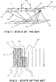
- bins 102 are virtually located at the bottom of the sea, and the purpose is to hit them through various kinds of reflected waves 108. These waves are captured by the receivers (sensors) 103.
- Source-receiver offset classes also referred to as “offset classes", are illustrated by vertical lines referenced 104, symbolizing the separators between offset classes.
- a source-receiver offset is an offset distance between source and receiver.
- Each bin 102 shall be hit enough through these offset classes, according to the client specification, so that the coverage can be considered correct.
- the wave 108 starts from the source 105, and ends at a receiver 103 after bouncing on a reflexion point 101.
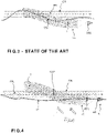
- the survey is discretized into preplot lines 124, 125, 126, etc.
- Those preplot lines are positioned on the survey area in such a way that following all of them with the streamers 107 aligned behind the vessel 106, would result in a perfect global coverage (a part of which corresponds to each of the preplot lines).
- the pilot of the vessel tries to steer the vessel to adjust the course of the vessel so that a dedicated part of the streamer spread remains in a corridor, corresponding to the desired coverage, which is defined around the preplot line.
- the line along which the vessel actually sails is called “sail line”.
- the sail line should be the preplot line, but can be different in some cases, e.g. if the vessel must avoid an obstacle located on the preplot line (oil platform, FPSO unit ("floating production, storage and offloading unit”), etc).
- the navigator human operator
- the usual process is to watch a binning software screen that illustrates the coverage provided by the vessel course with reference to the preplot lines, and to adjust the vessel course so as to juxtapose the coverage obtained when trying to follow a preplot line with the coverage obtained when trying to follow adjacent preplot line(s).
- Another drawback of the known solution is an excessive steering that often results in a too dynamic line, difficult to mimic in case of a future 4D survey based on the current one.
- the proposed method enables to take into account the impact of the water current on the streamer or streamer spread for various hypothetic vessel trajectories thanks to the modelling step, and then to determine an appropriate target course for the vessel according to which the vessel is steered.
- the method enables to anticipate and correct important streamer deviations compared to known solutions that are simply based on controlling birds, including major deviations.
- the proposed method can of course be further associated with other steering devices like birds on the streamer(s), for optimizing the position (trajectory) of the streamer(s).
- the method can include any features of the subclaims 2 to 11.
- the streamer vessel further tows one or a plurality of sources, also referred to as front sources, in front of the streamer or of the streamer spread.
- said one or plurality of sources towed by the source vessel also referred to as top sources, are towed above the streamer or the streamer spread.
- seismic vessel suitable for towing a streamer or a streamer spread, wherein the seismic vessel includes a navigation system as proposed above.
- the specification relates to a technique for steering a seismic vessel.
- the seismic vessel includes a towing system for towing at least one acoustic linear antenna, hereinafter named streamer.
- the streamer has the form of a cable that comprises sensors such as hydrophones.
- the sensors correspond to receivers that receive signals generated by at least one source and reflected by the subsurface layers at reflexion points, as already explained with regard to Figures 1 and 2 .
- the seismic vessel can tow a plurality of streamers which is referred to as a streamer spread.
- the streamers can be towed in parallel by the vessel or towed in a form of a funnel or according to another form.
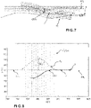
- the proposed technique enables to determine a target course of the vessel so that when the vessel is steered according to said target course, said point CS7 of the streamer 7 follows the desired trajectory PPL.
- it is represented the trajectory T7 of point P71 that is the beginning of the streamer 7 attached to the vessel. Said trajectory T7 of point P71 can be assimilated to the one of the vessel.
- the preplot line PPL corresponds to a line that the centre (mid-length and mid-width) of the streamer or streamer spread should follow during the survey.
- the description is provided for one preplot line but also applies for a plurality of preplot lines to obtain a desired corresponding bin coverage.
- the proposed technique also applies to any other desired trajectory.
- the point for which a trajectory is desired is the center of the streamer spread.
- the proposed technique also applies to any other point, or group of points, of the streamer spread or of a streamer.
- the description can thus also apply to one or more points of the streamer spread such as points between two streamers.
- the invention can apply to one streamer as well as a streamer spread.
- the description is provided for one seismic vessel but also applies to a plurality of seismic vessels.
- a streamer can be represented as a line of points of length noted L.
- Each point of the streamer can be defined by its distance along the streamer, noted h, to a given reference point, such as the extremity of the streamer that is on the vessel side, i.e. the beginning of the streamer.
- the vessel further includes a navigation system 60 that include a processing unit 610 and a steering unit 620 as detailed hereafter.
- the steering unit 620 is configured to steer the vessel 6 according to a determined target course T6, as illustrated in the example of Figure 8 , so that the vessel course (or sail line) resulting from the steering operation is consistent with the determined target course T6.
- the desired trajectory is the trajectory of the midpoint CS7 of the streamer 7 of the streamer spread 70 that follows a straight line corresponding to a preplot line PPL.
- the desired trajectory can be any one of the following:
- the desired trajectory can be provided to the navigation system via a user interface.
- the vessel comprises a processing unit 610 that is configured to acquire or determine water current values.
- Water current values can comprise values of water current in a zone that includes the desired trajectory PPL and/or values of the water current at a current and/or expected location of the streamer.
- the water current can be acquired or determined at current time, and predicted for a given future time, for instance 20-40 minutes after the current time.
- the water current can be data that are acquired or determined from an external source such as a marine database that can be accessible by a radio communication device of the processing unit 610.
- the processing unit 610 is also configured to take as input the desired trajectory PPL.
- the water current and the desired trajectory PPL for said point CS7 of the streamer 7, will thus be used by the processing unit 610 as inputs to determine a target course T6 for the vessel 6. Further inputs can be used to determine a target course T6 for the vessel 6. According to a particular embodiment, a target vessel speed is also determined and associated to the target course T6.
- the target course T6 is defined so that when the course (or sail line) of the vessel 6 follows said target course, the position TCS7 of point CS7 of the streamer 7, that results from such a vessel course, follows the desired trajectory PPL or follows a trajectory that is included in a predefined width corridor CR that contains said desired trajectory PPL.
- the processing unit 610 includes a streamer modelling system 611.
- the streamer modelling system 611 is described hereafter in the modelling case of one streamer, but this also applies to the modelling of a streamer spread.
- the various modelling of the trajectory of the streamer i.e. the positions that the points of the streamer take during a given hypothetic vessel course, is used for executing an inversion process, explained further below, that provides the vessel target course.
- the determination of the streamer shape enables to know the streamer positions (i.e. the positions taken by the points of the streamer all along the given hypothetic vessel course).
- the streamer modelling system 611 is configured for modelling the positions that the points of the streamer take, and thus the shape of the streamer, when said streamer is towed in water, in function of a given hypothetic vessel course, preferably along with a given hypothetic vessel speed, and in function of the water current that the streamer is assumed to be exposed during the given hypothetic vessel course.
- the modelling is repeated according to various given hypothetic vessel courses to provide various trajectories for the streamer.
- the modelling is iteratively executed by using as inputs the previous given hypothetic vessel course and the deviation between the corresponding previous modelled trajectory for the streamer and the desired trajectory.
- the streamer is considered as a line of points.
- the streamer can be defined by the vector C ⁇ ( h,t ), t being the time, and h being the distance of a point of the streamer, considered along the streamer, with reference to its extremity attached to the vessel.
- Figure 6 illustrates examples of forces that apply to a given point C ( h,t ) of a streamer when towed by a vessel according to an embodiment of the invention.
- the water current V is considered to be orthogonal to the tangent of the streamer 7 at said point CS7 of the cable.
- the modelling of the shape of the streamer is done by using as input a given hypothetic course, P ⁇ ( t ), of the vessel, along with a given hypothetic vessel speed, and the water current associated to this given course of the vessel.
- the speed and trajectory of the beginning point P71 of the streamer 7 can be considered as the vessel speed since the beginning of the streamer can be considered as fixed to the vessel.
- Equations can be solved by using these discrete quantities and finite difference approximations of differentials.
- the following approximations can be used for the x component of the streamer speed and streamer tangent respectively: ⁇ C i , j x ⁇ t ⁇ ⁇ C i , j x + C i , j + 1 x ⁇ t , ⁇ C i , j x ⁇ h ⁇ ⁇ C i ⁇ 1 , j x + C i , j x ⁇ h
- Further parameter(s) can be taken into account to model the shape of the streamer.
- physical properties of the streamer 7 related to its interaction with the water can be used as further inputs to enhance the modelling.
- Physical properties of the streamer can include at least one of the following: stiffness of the streamer, resistance of the streamer to side slip through the water (the s c parameter mentioned above), resistance to parallel slip (the s p parameter mentioned above), force of one or more steering devices attached to the streamer, and/or force of tail buoy(s) attached to the streamer.
- the processing unit 610 includes an inversion system 612 configured to apply an inversion scheme to determine the target course T6 for the vessel 6.
- the inversion system 612 takes as input various modelled trajectories of the streamer that result from various given hypothetic courses of the vessel, with associated vessel speed, that have been considered by the modelling system.
- the inversion system 612 is configured to determine among the various modelled trajectories of the extreme front of the streamer the one that corresponds to the desired property or position of the whole, or parts, of the streamer.
- the inversion scheme thus enables to find an optimum vessel course.
- an object function Obj ⁇ P ( t ) ⁇ is defined, which is a function of the trajectory of the streamer extremity attached to the vessel, given by the vector P ⁇ ( t ) where t is time.
- the object function Obj ⁇ P( t ) ⁇ is defined as Obj P t ⁇ ⁇ 0 T D t 2 d t where D ( t ) is the perpendicular distance from the centre of spread CP ( t ) to the desired trajectory for the centre of spread and P ⁇ ( t ) is the trajectory of the beginning point of the streamer 7 in the streamer spread 70
- the streamer modelling system computes the object function Obj ⁇ P( t ) ⁇ for a plurality of trajectories P( t ).
- the inversion consists in finding a specific P ⁇ ( t ) which minimizes Obj ⁇ P ⁇ ( t ) ⁇ .
- the inversion consists in finding the one, P ⁇ 0 ( t ), which minimizes the object function Obj ⁇ P ⁇ ( t ) ⁇ :
- Min Obj P ⁇ t Obj ⁇ P ⁇ 0 t
- the inversion is based on a steepest descent method.
- the steepest descent method can be executed by initially defining a first initial vessel course (path) and corresponding initial speed, corresponding to a guess of the vessel course and speed, and by comparing the resulting modelled position (trajectory) of the streamer with the desired trajectory for the streamer.
- This first initial vessel course and/ or initial speed is adjusted iteratively to minimize the misfit (difference) between the desired trajectory for the streamer and the modelled trajectory for the streamer obtained as a result of the vessel course.
- newton's method can be used.
- the above-described functions and steps related to the operations of modelling, inversion and steering may be implemented in the form of a computer program or via hardware components (e.g. programmable gate arrays).
- the functions and the steps performed by the modelling system, the inversion system and the steering system may be performed by sets of computer instructions or modules implemented by a processor or a controller or they may be performed by dedicated electronic components of the field-programmable gate array (FPGA) or application-specific integrated circuit (ASIC) type. It is also possible to combine computer parts and electronic parts.
- FPGA field-programmable gate array
- ASIC application-specific integrated circuit
- the computer programs, or computer instructions may be contained in program storage devices, e.g. computer-readable digital data storage media, or executable programs.
- the programs or instructions may also be executed from program storage peripherals.
- the navigation system 60 can comprise the processing unit 610 equipped for example with a microprocessor, and driven by a computer program implementing the steps of the method for determining a target trajectory T6 for the vessel as described herein.
- the processing unit 610 can take as inputs the desired trajectory for at least one point of the streamer or streamer spread, hypothetic given vessel courses and corresponding vessel speed, and the water current in the navigation area of the vessel.
- the modelling system 611 and the inversion system 612 can be part of the computer program.
- the determined target trajectory T6 outputted by the inversion system 612 can then be communicated to the steering system 620.
- the method is applied to a point CS7 of the streamer that is the middle of the streamer 7 or streamer spread 70, but the method can be applied to another point of the streamer or streamer spread, and for another desired trajectory that the preplot line PPL or to a plurality of preplot lines.
- the trajectory which is desired for point CS7 of the streamer is acquired or determined (for instance by computing data) by the processing unit.
- the trajectory can be defined for instance by an operator on a user interface of the navigation system.
- the desired trajectory which is defined is the preplot line PPL.
- the water current is acquired by the processing unit for a given range of time and with regard to the expected navigation zone.
- the water current V ( x ,t ) is perpendicular to the preplot line PPL, the preplot line PPL being parallel to the axis x.
- the modelling system 611 of the processing unit 610 models streamer trajectories with regard to hypothetic given vessel courses.
- the modelling system 611 models the streamer shape, i.e. positions taken by points of the streamer, during given hypothetic vessel courses and associated hypothetic speed values.
- the trajectory of the streamer can be modelled based on the determined shape of the streamer and on the position and speed of the beginning of the streamer attached to the vessel, that can be derived from the speed and given course of the vessel.
- the modelling can start with an initial guess for the given vessel course which is modified (perturbed) for the next modelling so as to generate next given vessel courses that differ from the previous ones.
- the inversion system 612 of the processing unit 6100 proceeds to an inversion process by determining among the modelled streamer trajectories, the one that provides a trajectory for point CS7 that is the closest to the desired trajectory PPL.
- the processing unit 610 thus determines as the target vessel source T6 and associated target speed value, the given hypothetic vessel course and associated hypothetic speed value that has been used to model the determined streamer trajectory that is the closest to the desired trajectory for point CS7.
- the vessel course used as input for the modelling can be modified until the resulting modelled streamer position is close enough to the desired properties.
- the processing unit 610 provides the determined target vessel course T6 to the steering device 620 so that at step 1060 the steering device 620 steers the vessel to correct the current vessel course according to the target T6 vessel course.
- the proposed navigation system and corresponding method thus enables to find an optimum course for the vessel, by using many possible trajectories (courses) for the vessel to model many versions of streamer trajectories and then to choose the vessel course that gives the streamer trajectory that is the closest to one or several of the desired properties mentioned above.
- the target vessel source T6 can be updated regularly as the streamer vessel moves along the sail line.
- the present invention allows to take the maximum of the TopSeis TM acquisition advantages, by optimizing the relative position of the source above the streamer spread, thereby enhancing the quality of the resulting data.
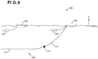
- TopSeis TM configuration 300 An example of a TopSeis TM configuration 300 is illustrated in Figure 9 .
- the TopSeis TM configuration 300 includes a streamer vessel 302 that tows a streamer spread 304, the streamer spread 304 including a given number of streamers 306, and a source vessel 320 that tows plural sources 322 over the streamer spread. These sources are called herein top sources because they are located above (along a vertical direction Z) the streamer spread.
- the streamer vessel 302 also tows plural sources 308, which are called herein front sources because these sources are located in front (along the inline direction X) of the streamer spread 304.
- Figure 9 shows the streamer spread 304 being connected at point 310 to the streamer vessel 302 by towlines 309, which are not part of the streamer spread.
- the front sources 308 are not directly above (along the vertical Z direction) the streamer spread 304.
- the streamer vessel 302 may be configured to tow both the front sources 308 and the top sources 322.
- Figure 9 shows two vessels towing the two sets of sources, in one application it is possible to tow all the sources, front and top, with the streamer vessel 302. In another application, it is possible to tow the front sources with the streamer vessel 302 and to have the top sources independently carried by their own carrier, e.g., small boat, autonomous underwater vehicle (AUV), etc.
- AUV autonomous underwater vehicle
- the front sources 308 are aligned (centered) with the sail line of the vessel (i.e the vessel course), preferably in the middle of the beginning of the streamer spread.
- the top sources 320 are preferably offset along a cross line direction from the front sources 308.
- the streamer spread positions are modelled as proposed above taking into account the water current, and the inversion process is executed, as proposed above, using the modelled positions of the streamer spread, to determine the vessel course that leads to the desired property for the streamer spread.
- desired property can be that a dedicated part or point of the streamer spread remains on a preplot line or in a corridor, corresponding to the desired coverage, which is defined around the preplot line.
- the dedicated part of the streamer spread can be a point positioned at the centre of the streamer spread (that point can be a point on a streamer or a point between two streamers). Then the streamer vessel 302 is steered according to the determined vessel course that is considered as a target vessel course.
- the present invention can be applied notably to the oil exploration industry, but may also be applied to any field using a geophysical data acquisition network in a marine environment. It may also be use in any situation when a streamer, or any cable, is pulled through the water, also not for acquiring geophysical data.
- the present invention can also be applied for having the desired trajectory defined through:
Landscapes
- Life Sciences & Earth Sciences (AREA)
- Engineering & Computer Science (AREA)
- Physics & Mathematics (AREA)
- Chemical & Material Sciences (AREA)
- Ocean & Marine Engineering (AREA)
- Mechanical Engineering (AREA)
- Combustion & Propulsion (AREA)
- Acoustics & Sound (AREA)
- General Life Sciences & Earth Sciences (AREA)
- General Physics & Mathematics (AREA)
- Geophysics (AREA)
- Remote Sensing (AREA)
- Geology (AREA)
- Environmental & Geological Engineering (AREA)
- Oceanography (AREA)
- Geophysics And Detection Of Objects (AREA)
- Control Of Position, Course, Altitude, Or Attitude Of Moving Bodies (AREA)
- Navigation (AREA)
- Steering Control In Accordance With Driving Conditions (AREA)
Priority Applications (6)
| Application Number | Priority Date | Filing Date | Title |
|---|---|---|---|
| EP21305119.6A EP4036610A1 (fr) | 2021-01-29 | 2021-01-29 | Procédé pour diriger un navire, système de navigation associé et procédé d'acquisition de données sismiques |
| EP22701635.9A EP4285164B1 (fr) | 2021-01-29 | 2022-01-25 | Procédé pour diriger un navire, système de navigation associé et procédé d'acquisition de données sismiques |
| PCT/EP2022/051651 WO2022161957A1 (fr) | 2021-01-29 | 2022-01-25 | Procédé de pilotage d'un navire, système de navigation associé et procédé d'acquisition de données sismiques |
| MX2023008226A MX2023008226A (es) | 2021-01-29 | 2022-01-25 | Metodo para dirigir una embarcacion, sistema de navegacion y metodo para adquisicion de datos sismicos relacionados. |
| US18/273,545 US20240159932A1 (en) | 2021-01-29 | 2022-01-25 | Method for steering a vessel, related navigation system and method for seismic data acquisition |
| AU2022212419A AU2022212419B2 (en) | 2021-01-29 | 2022-01-25 | Method for steering a vessel, related navigation system and method for seismic data acquisition |
Applications Claiming Priority (1)
| Application Number | Priority Date | Filing Date | Title |
|---|---|---|---|
| EP21305119.6A EP4036610A1 (fr) | 2021-01-29 | 2021-01-29 | Procédé pour diriger un navire, système de navigation associé et procédé d'acquisition de données sismiques |
Publications (1)
| Publication Number | Publication Date |
|---|---|
| EP4036610A1 true EP4036610A1 (fr) | 2022-08-03 |
Family
ID=74553762
Family Applications (2)
| Application Number | Title | Priority Date | Filing Date |
|---|---|---|---|
| EP21305119.6A Withdrawn EP4036610A1 (fr) | 2021-01-29 | 2021-01-29 | Procédé pour diriger un navire, système de navigation associé et procédé d'acquisition de données sismiques |
| EP22701635.9A Active EP4285164B1 (fr) | 2021-01-29 | 2022-01-25 | Procédé pour diriger un navire, système de navigation associé et procédé d'acquisition de données sismiques |
Family Applications After (1)
| Application Number | Title | Priority Date | Filing Date |
|---|---|---|---|
| EP22701635.9A Active EP4285164B1 (fr) | 2021-01-29 | 2022-01-25 | Procédé pour diriger un navire, système de navigation associé et procédé d'acquisition de données sismiques |
Country Status (5)
| Country | Link |
|---|---|
| US (1) | US20240159932A1 (fr) |
| EP (2) | EP4036610A1 (fr) |
| AU (1) | AU2022212419B2 (fr) |
| MX (1) | MX2023008226A (fr) |
| WO (1) | WO2022161957A1 (fr) |
Cited By (2)
| Publication number | Priority date | Publication date | Assignee | Title |
|---|---|---|---|---|
| CN115358100A (zh) * | 2022-10-21 | 2022-11-18 | 山东大学 | 一种海洋拖曳系统多目标优化方法及装置 |
| CN117540598A (zh) * | 2023-11-14 | 2024-02-09 | 重庆交通大学 | 一种超标横流条件下航道宽度的确定方法 |
Families Citing this family (2)
| Publication number | Priority date | Publication date | Assignee | Title |
|---|---|---|---|---|
| US20250113122A1 (en) * | 2023-09-29 | 2025-04-03 | GM Global Technology Operations LLC | Telematics system |
| CN117612409B (zh) * | 2024-01-23 | 2024-04-05 | 广州市勤思网络科技有限公司 | 水上物体的超区预警方法及装置 |
Citations (8)
| Publication number | Priority date | Publication date | Assignee | Title |
|---|---|---|---|---|
| US20070064526A1 (en) * | 2005-08-26 | 2007-03-22 | Holo Andreas T | Automatic systems and methods for positioning marine seismic equipment |
| US20110002193A1 (en) * | 2006-03-21 | 2011-01-06 | Eskild Storteig | Active steering systems and methods for marine seismic sources |
| US20150016218A1 (en) * | 2004-03-17 | 2015-01-15 | Westerngeco L.L.C. | Marine seismic survey method and system |
| EP2889645A1 (fr) | 2013-12-31 | 2015-07-01 | Sercel | Procédé et dispositif pour diriger un navire sismique |
| US9810802B2 (en) | 2015-04-08 | 2017-11-07 | Sercel | Method for managing the target location of a vessel |
| US20190235117A1 (en) * | 2016-10-19 | 2019-08-01 | Polarcus Dmcc | Positioning of seismic equipment in a towed marine array |
| US20190377348A1 (en) | 2018-06-10 | 2019-12-12 | Ion Geophysical Corporation | Control system for steerable towed marine equipment |
| WO2020008259A1 (fr) | 2018-07-06 | 2020-01-09 | Sercel | Procédé et système d'acquisition de données sismiques avec des sources avant et supérieure |
Family Cites Families (2)
| Publication number | Priority date | Publication date | Assignee | Title |
|---|---|---|---|---|
| US20110286302A1 (en) * | 2004-03-17 | 2011-11-24 | Westerngeco, L.L.C. | Marine Seismic Survey Method and System |
| MX2016006408A (es) * | 2013-11-18 | 2016-08-01 | Cgg Services Sa | Dispositivo y metodo para dirigir una embarcacion sismica. |
-
2021
- 2021-01-29 EP EP21305119.6A patent/EP4036610A1/fr not_active Withdrawn
-
2022
- 2022-01-25 EP EP22701635.9A patent/EP4285164B1/fr active Active
- 2022-01-25 WO PCT/EP2022/051651 patent/WO2022161957A1/fr not_active Ceased
- 2022-01-25 AU AU2022212419A patent/AU2022212419B2/en not_active Ceased
- 2022-01-25 US US18/273,545 patent/US20240159932A1/en active Pending
- 2022-01-25 MX MX2023008226A patent/MX2023008226A/es unknown
Patent Citations (8)
| Publication number | Priority date | Publication date | Assignee | Title |
|---|---|---|---|---|
| US20150016218A1 (en) * | 2004-03-17 | 2015-01-15 | Westerngeco L.L.C. | Marine seismic survey method and system |
| US20070064526A1 (en) * | 2005-08-26 | 2007-03-22 | Holo Andreas T | Automatic systems and methods for positioning marine seismic equipment |
| US20110002193A1 (en) * | 2006-03-21 | 2011-01-06 | Eskild Storteig | Active steering systems and methods for marine seismic sources |
| EP2889645A1 (fr) | 2013-12-31 | 2015-07-01 | Sercel | Procédé et dispositif pour diriger un navire sismique |
| US9810802B2 (en) | 2015-04-08 | 2017-11-07 | Sercel | Method for managing the target location of a vessel |
| US20190235117A1 (en) * | 2016-10-19 | 2019-08-01 | Polarcus Dmcc | Positioning of seismic equipment in a towed marine array |
| US20190377348A1 (en) | 2018-06-10 | 2019-12-12 | Ion Geophysical Corporation | Control system for steerable towed marine equipment |
| WO2020008259A1 (fr) | 2018-07-06 | 2020-01-09 | Sercel | Procédé et système d'acquisition de données sismiques avec des sources avant et supérieure |
Non-Patent Citations (1)
| Title |
|---|
| DR. GERARD T. SCHUSTER: "Seismic Inversion", 1 January 2017, SOCIETY OF EXPLORATION GEOPHYSICISTS, article "Steepest-Descent Method" |
Cited By (2)
| Publication number | Priority date | Publication date | Assignee | Title |
|---|---|---|---|---|
| CN115358100A (zh) * | 2022-10-21 | 2022-11-18 | 山东大学 | 一种海洋拖曳系统多目标优化方法及装置 |
| CN117540598A (zh) * | 2023-11-14 | 2024-02-09 | 重庆交通大学 | 一种超标横流条件下航道宽度的确定方法 |
Also Published As
| Publication number | Publication date |
|---|---|
| AU2022212419A1 (en) | 2023-07-20 |
| AU2022212419A9 (en) | 2025-01-30 |
| MX2023008226A (es) | 2023-07-20 |
| WO2022161957A1 (fr) | 2022-08-04 |
| AU2022212419B2 (en) | 2024-08-29 |
| US20240159932A1 (en) | 2024-05-16 |
| EP4285164B1 (fr) | 2025-08-13 |
| EP4285164A1 (fr) | 2023-12-06 |
Similar Documents
| Publication | Publication Date | Title |
|---|---|---|
| EP4285164B1 (fr) | Procédé pour diriger un navire, système de navigation associé et procédé d'acquisition de données sismiques | |
| US6477470B2 (en) | Method and system for deghosting | |
| CN1954239B (zh) | 增强盐下成像的低频采集和处理 | |
| AU2006252148B2 (en) | Methods and systems for efficiently acquiring towed streamer seismic surveys | |
| EP2904426B1 (fr) | Dispositif et procédé de direction de navire sismique | |
| MX2010013018A (es) | Metodo para determinar la desviacion del equipo sismico desde una trayectoria curvada planificada. | |
| CN105960600B (zh) | 在多个地震勘探船之间具有变化相对距离的地震数据获取 | |
| US20160259077A1 (en) | Method for determining a collision free sail path of at least one vessel of a fleet of vessels, corresponding device, computer program product and non-transitory computer-readable carrier medium | |
| Lamarche et al. | Benthic habitat mapping | |
| US20160259076A1 (en) | Method for determining a sail path of at least one vessel of a fleet of vessels, corresponding device, computer program product and non-transitory computer-readable carrier medium | |
| US9322946B2 (en) | Method for steering a towed acoustic linear antenna | |
| EP2690461B1 (fr) | Procédé pour estimer la vitesse de l'eau d'un noeud acoustique | |
| US9284033B2 (en) | Method and device for steering a seismic vessel, on the basis of boundaries of binning coverage zones | |
| US10042065B2 (en) | Method and device for steering a seismic vessel | |
| Caiti et al. | Innovative technologies in underwater archaeology: field experience, open problems, and research lines | |
| US11988791B2 (en) | Sparse seismic data acquisition | |
| RU2858700C1 (ru) | Комплекс и способ проведения морских синхронных инженерных и нефтегазовых сейсмических исследований | |
| US12379517B2 (en) | Using ambient acoustic energy as a passive source in marine seismic surveys | |
| Caiti et al. | Underwater archaeology: available techniques and open problems in fully automated search and inspection | |
| FR2947390A1 (fr) | Procede d'aide au positionnement d'antennes acoustiques lineaires remorquees, comprenant une etape de definition et une etape de generation de cyvles acoustiques distincts | |
| Thomas et al. | 3D High Resolution academic seismic: Raw data amplitude monitoring–A mandatory early processing step |
Legal Events
| Date | Code | Title | Description |
|---|---|---|---|
| PUAI | Public reference made under article 153(3) epc to a published international application that has entered the european phase |
Free format text: ORIGINAL CODE: 0009012 |
|
| STAA | Information on the status of an ep patent application or granted ep patent |
Free format text: STATUS: THE APPLICATION HAS BEEN PUBLISHED |
|
| AK | Designated contracting states |
Kind code of ref document: A1 Designated state(s): AL AT BE BG CH CY CZ DE DK EE ES FI FR GB GR HR HU IE IS IT LI LT LU LV MC MK MT NL NO PL PT RO RS SE SI SK SM TR |
|
| STAA | Information on the status of an ep patent application or granted ep patent |
Free format text: STATUS: THE APPLICATION IS DEEMED TO BE WITHDRAWN |
|
| 18D | Application deemed to be withdrawn |
Effective date: 20230204 |