EP4092985A1 - Positionierungsverfahren, -vorrichtung und -system für benutzerendgeräte - Google Patents
Positionierungsverfahren, -vorrichtung und -system für benutzerendgeräte Download PDFInfo
- Publication number
- EP4092985A1 EP4092985A1 EP20915919.3A EP20915919A EP4092985A1 EP 4092985 A1 EP4092985 A1 EP 4092985A1 EP 20915919 A EP20915919 A EP 20915919A EP 4092985 A1 EP4092985 A1 EP 4092985A1
- Authority
- EP
- European Patent Office
- Prior art keywords
- service area
- location service
- user terminal
- correction model
- cloud server
- Prior art date
- Legal status (The legal status is an assumption and is not a legal conclusion. Google has not performed a legal analysis and makes no representation as to the accuracy of the status listed.)
- Pending
Links
Images


Classifications
-
- H—ELECTRICITY
- H04—ELECTRIC COMMUNICATION TECHNIQUE
- H04L—TRANSMISSION OF DIGITAL INFORMATION, e.g. TELEGRAPHIC COMMUNICATION
- H04L67/00—Network arrangements or protocols for supporting network services or applications
- H04L67/01—Protocols
- H04L67/10—Protocols in which an application is distributed across nodes in the network
-
- G—PHYSICS
- G01—MEASURING; TESTING
- G01S—RADIO DIRECTION-FINDING; RADIO NAVIGATION; DETERMINING DISTANCE OR VELOCITY BY USE OF RADIO WAVES; LOCATING OR PRESENCE-DETECTING BY USE OF THE REFLECTION OR RERADIATION OF RADIO WAVES; ANALOGOUS ARRANGEMENTS USING OTHER WAVES
- G01S19/00—Satellite radio beacon positioning systems; Determining position, velocity or attitude using signals transmitted by such systems
- G01S19/01—Satellite radio beacon positioning systems transmitting time-stamped messages, e.g. GPS [Global Positioning System], GLONASS [Global Orbiting Navigation Satellite System] or GALILEO
- G01S19/03—Cooperating elements; Interaction or communication between different cooperating elements or between cooperating elements and receivers
- G01S19/07—Cooperating elements; Interaction or communication between different cooperating elements or between cooperating elements and receivers providing data for correcting measured positioning data, e.g. DGPS [differential GPS] or ionosphere corrections
- G01S19/071—DGPS corrections
-
- G—PHYSICS
- G01—MEASURING; TESTING
- G01S—RADIO DIRECTION-FINDING; RADIO NAVIGATION; DETERMINING DISTANCE OR VELOCITY BY USE OF RADIO WAVES; LOCATING OR PRESENCE-DETECTING BY USE OF THE REFLECTION OR RERADIATION OF RADIO WAVES; ANALOGOUS ARRANGEMENTS USING OTHER WAVES
- G01S19/00—Satellite radio beacon positioning systems; Determining position, velocity or attitude using signals transmitted by such systems
- G01S19/38—Determining a navigation solution using signals transmitted by a satellite radio beacon positioning system
- G01S19/39—Determining a navigation solution using signals transmitted by a satellite radio beacon positioning system the satellite radio beacon positioning system transmitting time-stamped messages, e.g. GPS [Global Positioning System], GLONASS [Global Orbiting Navigation Satellite System] or GALILEO
- G01S19/40—Correcting position, velocity or attitude
- G01S19/41—Differential correction, e.g. DGPS [differential GPS]
-
- G—PHYSICS
- G01—MEASURING; TESTING
- G01S—RADIO DIRECTION-FINDING; RADIO NAVIGATION; DETERMINING DISTANCE OR VELOCITY BY USE OF RADIO WAVES; LOCATING OR PRESENCE-DETECTING BY USE OF THE REFLECTION OR RERADIATION OF RADIO WAVES; ANALOGOUS ARRANGEMENTS USING OTHER WAVES
- G01S19/00—Satellite radio beacon positioning systems; Determining position, velocity or attitude using signals transmitted by such systems
- G01S19/38—Determining a navigation solution using signals transmitted by a satellite radio beacon positioning system
- G01S19/39—Determining a navigation solution using signals transmitted by a satellite radio beacon positioning system the satellite radio beacon positioning system transmitting time-stamped messages, e.g. GPS [Global Positioning System], GLONASS [Global Orbiting Navigation Satellite System] or GALILEO
- G01S19/42—Determining position
- G01S19/45—Determining position by combining measurements of signals from the satellite radio beacon positioning system with a supplementary measurement
- G01S19/46—Determining position by combining measurements of signals from the satellite radio beacon positioning system with a supplementary measurement the supplementary measurement being of a radio-wave signal type
-
- H—ELECTRICITY
- H04—ELECTRIC COMMUNICATION TECHNIQUE
- H04L—TRANSMISSION OF DIGITAL INFORMATION, e.g. TELEGRAPHIC COMMUNICATION
- H04L67/00—Network arrangements or protocols for supporting network services or applications
- H04L67/50—Network services
- H04L67/52—Network services specially adapted for the location of the user terminal
-
- H—ELECTRICITY
- H04—ELECTRIC COMMUNICATION TECHNIQUE
- H04W—WIRELESS COMMUNICATION NETWORKS
- H04W4/00—Services specially adapted for wireless communication networks; Facilities therefor
- H04W4/02—Services making use of location information
-
- G—PHYSICS
- G01—MEASURING; TESTING
- G01S—RADIO DIRECTION-FINDING; RADIO NAVIGATION; DETERMINING DISTANCE OR VELOCITY BY USE OF RADIO WAVES; LOCATING OR PRESENCE-DETECTING BY USE OF THE REFLECTION OR RERADIATION OF RADIO WAVES; ANALOGOUS ARRANGEMENTS USING OTHER WAVES
- G01S19/00—Satellite radio beacon positioning systems; Determining position, velocity or attitude using signals transmitted by such systems
- G01S19/01—Satellite radio beacon positioning systems transmitting time-stamped messages, e.g. GPS [Global Positioning System], GLONASS [Global Orbiting Navigation Satellite System] or GALILEO
- G01S19/03—Cooperating elements; Interaction or communication between different cooperating elements or between cooperating elements and receivers
- G01S19/09—Cooperating elements; Interaction or communication between different cooperating elements or between cooperating elements and receivers providing processing capability normally carried out by the receiver
-
- Y—GENERAL TAGGING OF NEW TECHNOLOGICAL DEVELOPMENTS; GENERAL TAGGING OF CROSS-SECTIONAL TECHNOLOGIES SPANNING OVER SEVERAL SECTIONS OF THE IPC; TECHNICAL SUBJECTS COVERED BY FORMER USPC CROSS-REFERENCE ART COLLECTIONS [XRACs] AND DIGESTS
- Y02—TECHNOLOGIES OR APPLICATIONS FOR MITIGATION OR ADAPTATION AGAINST CLIMATE CHANGE
- Y02D—CLIMATE CHANGE MITIGATION TECHNOLOGIES IN INFORMATION AND COMMUNICATION TECHNOLOGIES [ICT], I.E. INFORMATION AND COMMUNICATION TECHNOLOGIES AIMING AT THE REDUCTION OF THEIR OWN ENERGY USE
- Y02D30/00—Reducing energy consumption in communication networks
- Y02D30/70—Reducing energy consumption in communication networks in wireless communication networks
Definitions
- the disclosure belongs to the technical field of high-precision positioning, and in particular to a user terminal positioning method, an edge cloud server, a public cloud server, a user terminal, and a system.
- Satellite positioning technology means that a terminal calculates a coordinate location thereof by receiving a navigation signal broadcast by a satellite.
- the precision of the positioning technology is affected by ionosphere, troposphere, clock error and other factors.
- a ground-based satellite augmentation system is to build a reference station network at a known location to continuously observe the satellite navigation signal and transmit observed data back to a high-precision positioning platform.
- the high-precision positioning platform calculates location correction information of the whole network according to an observed value and a real value of the reference station network.
- the positioning terminal may calculate the high-precision location information thereof by observing the satellite navigation signal and receiving location correction information of an area where the positioning terminal is located.
- a network architecture of the high-precision positioning system in the related art is designed for wide-area service coverage (such as the whole country, the whole province, and the whole city).
- wide-area service coverage such as the whole country, the whole province, and the whole city.
- some local, closed and mobile service scenarios such as mining areas and forest areas
- the positioning service quality will be affected and the service construction and maintenance costs will be increased.
- Embodiments of the disclosure provide a user terminal positioning method, an edge cloud server, a public cloud server, a user terminal, and a system, which can improve the positioning accuracy of the user terminal.
- a user terminal positioning method is provided, which is applied to an edge cloud server and includes the following operations.
- Satellite positioning information is received from a user terminal.
- a location service area where the user terminal is located is determined.
- a differential correction model corresponding to the location service area is acquired from a public cloud server according to the location service area.
- Location calculation is performed using the satellite positioning information and the differential correction model to obtain location information of the user terminal.
- the location information is sent to the user terminal.
- the operation of acquiring the differential correction model corresponding to the location service area from the public cloud server according to the location service area includes the following operations.
- a location service area request corresponding to the location service area is sent to the public cloud server.
- the differential correction model corresponding to the location service area is received from the public cloud server.
- a user terminal positioning method is provided, which is applied to a public cloud server and includes the following operations.
- a location service area request is received from an edge cloud server.
- the location service area request is parsed and a location service area corresponding to the location service area request is determined.
- a differential correction model corresponding to the location service area is matched according to the location service area.
- the differential correction model is sent to the edge cloud server such that the edge cloud server determines location information of a user terminal according to the differential correction model.
- the following operations may further be included.
- a satellite observation data packet is received from a ground-based augmentation reference station network.
- the satellite observation data packet is parsed to obtain respective observation data of each reference station in the ground-based augmentation reference station network.
- a coverage area of the ground-based augmentation reference station network is divided to obtain a preset number of grid coverage areas.
- a differential correction model of any grid coverage area is determined according to observation data and accurate location coordinates of a reference station in the grid coverage area.
- the operation of matching the differential correction model corresponding to the location service area according to the location service area may include the following operations.
- a grid coverage area to which the location service area belongs is determined.
- the differential correction model corresponding to the location service area is matched.
- a user terminal positioning method is provided, which is applied to a user terminal and includes the following operations.
- Satellite positioning information is received from a satellite.
- the satellite positioning information is sent to an edge cloud server to acquire location information of the user terminal.
- an edge cloud server which includes: a satellite positioning information receiving module, a location service area determination module, a differential correction model acquisition module, a location calculation module, and a location information sending module.
- the satellite positioning information receiving module is configured to receive satellite positioning information from a user terminal.
- the location service area determination module is configured to determine a location service area where the user terminal is located.
- the differential correction model acquisition module is configured to acquire a differential correction model corresponding to the location service area from a public cloud server according to the location service area.
- the location calculation module is configured to perform location calculation using the satellite positioning information and the differential correction model to obtain location information of the user terminal.
- the location information sending module is configured to send the location information to the user terminal.
- the differential correction model acquisition module may include a location service area request sending unit and a differential correction model receiving unit.
- the location service area request sending unit is configured to send a location service area request corresponding to the location service area to the public cloud server.
- the differential correction model receiving unit is configured to receive the differential correction model corresponding to the location service area from the public cloud server.
- a public cloud server which includes: a location service area request receiving module, a location service area request parsing module, a differential correction model matching model, and a differential correction model sending module.
- the location service area request receiving module is configured to receive a location service area request from an edge cloud server.
- the location service area request parsing module is configured to parse the location service area request and determine a location service area corresponding to the location service area request.
- the differential correction model matching module is configured to match a differential correction model corresponding to the location service area according to the location service area.
- the differential correction model sending module is configured to send the differential correction model to the edge cloud server such that the edge cloud server determines location information of a user terminal according to the differential correction model.
- the public cloud server may further include: a satellite observation data packet receiving module, a satellite observation data packet parsing module, a coverage area division module, and a differential correction model determination module.
- the satellite observation data packet receiving module is configured to receive a satellite observation data packet from a ground-based augmentation reference station network.
- the satellite observation data packet parsing module is configured to parse a satellite observation data packet to obtain respective observation data of each reference station in the ground-based augmentation reference station network.
- the coverage area division module is configured to divide a coverage area of the ground-based augmentation reference station network to obtain a preset number of grid coverage areas.
- the differential correction model determination module is configured to determine a differential correction model of any grid coverage area according to observation data and accurate location coordinates of a reference station in the grid coverage area.
- the differential correction model matching module may include: a grid coverage area determination unit, and a differential correction model matching unit.
- the grid coverage area determination unit is configured to determine, based on the location service area, a grid coverage area to which the location service area belongs.
- the differential correction model matching unit is configured to match, according to the grid coverage area to which the location service area belongs, the differential correction model corresponding to the location service area.
- a user terminal which includes a satellite positioning information receiving module and a satellite positioning information sending module.
- the satellite positioning information receiving module is configured to receive satellite positioning information from a satellite.
- the satellite positioning information sending module is configured to send the satellite positioning information to an edge cloud server to acquire location information of the user terminal.
- a user terminal positioning system includes an edge cloud server, a public cloud server and a user terminal.
- the edge cloud server is configured to execute the user terminal positioning method of the first aspect.
- the public cloud server is configured to execute the user terminal positioning method of the second aspect.
- the user terminal is configured to execute the user terminal positioning method of the third aspect.
- the positioning precision of the user terminal can be improved.
- the differential correction model corresponding to the location service area is acquired from the public cloud server according to the location service area where the user terminal is located. Since the differential correction model corresponds to the location service area where the user terminal is located, the satellite positioning information and the differential correction model are used to perform location calculation to obtain the location information of the user terminal, which can improve the positioning precision of the user terminal.
- a network architecture of the high-precision positioning system in the related art is designed for wide-area service coverage (such as the whole country, the whole province and the whole city).
- wide-area service coverage such as the whole country, the whole province and the whole city.
- some local, closed and mobile service scenarios such as mining areas and forest areas
- the positioning service quality will be affected and the service construction and maintenance costs will be increased.
- the embodiments of the disclosure provide a user terminal positioning method, an edge cloud server, a public cloud server, a user terminal, and a system.
- the user terminal positioning method provided by the embodiments of the present disclosure is first introduced below.
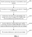
- FIG. 1 is a flowchart of a user terminal positioning method according to an embodiment of the disclosure. As shown in FIG. 1 , the user terminal positioning method is applied to an edge cloud server and includes the following operations.
- satellite positioning information is received from a user terminal.
- a location service area where the user terminal is located is determined.
- a differential correction model corresponding to the location service area is acquired from a public cloud server according to the location service area.
- the operation of acquiring the differential correction model corresponding to the location service area from the public cloud server according to the location service area includes that: a location service area request corresponding to the location service area is sent to the public cloud server; and the differential correction model corresponding to the location service area sent by the public cloud server is received.
- location calculation is performed using the satellite positioning information and the differential correction model to obtain location information of the user terminal.
- the location information is sent to the user terminal.
- the edge cloud server After acquiring the differential correction model corresponding to the location service area, the edge cloud server uses the satellite positioning information and the differential correction model to perform location calculation to obtain the location information of the user terminal, and sends the location information to the user terminal.
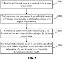
- FIG. 2 is a flowchart of another user terminal positioning method according to an embodiment of the disclosure. As shown in FIG. 2 , the user terminal positioning method is applied to a public cloud server, which includes the following operations.
- a location service area request is received from an edge cloud server.
- the location service area request is parsed and a location service area corresponding to the location service area request is determined.
- a differential correction model corresponding to the location service area is matched according to the location service area.
- the method before matching the differential correction model corresponding to the location service area according to the location service area, includes the following operations.
- a satellite observation data packet sent by a ground-based augmentation reference station network is received; the satellite observation data packet is parsed to obtain respective observation data of each reference station in the ground-based augmentation reference station network; a coverage area of the ground-based augmentation reference station network is divided to obtain a preset number of grid coverage areas; and a differential correction model of any grid coverage area is determined according to observation data and accurate location coordinates of a reference station in the grid coverage area.
- the operation of matching the differential correction model corresponding to the location service area according to the location service area may include that: a grid coverage area to which the location service area belongs is determined based on the location service area; and the differential correction model corresponding to the location service area is matched according to the grid coverage area to which the location service area belongs.
- the differential correction model is sent to the edge cloud server such that the edge cloud server determines location information of a user terminal according to the differential correction model.
- FIG. 3 is a flowchart of yet another user terminal positioning method according to an embodiment of the disclosure. As shown in FIG. 3 , the user terminal positioning method is applied to a user terminal, which includes the following operations.
- satellite positioning information is received from a satellite.
- the satellite positioning information is sent to an edge cloud server to acquire location information of the user terminal.
- the embodiment provides a positioning system and an implementation method based on edge cloud technology.
- public cloud is a public cloud server
- edge cloud is an edge cloud server
- a terminal is a user terminal.
- the positioning system consists of a ground-based augmentation station network composed of reference stations distributed in a positioning service area, a high-precision positioning platform configured on the public cloud server, a location calculation platform configured on the edge cloud server and the user terminal.
- the high-precision positioning platform is responsible for calculating the differential correction model of the whole network according to the observation data of the ground-based augmentation station network, and matching the corresponding area correction model according to the service area of the edge cloud server for broadcasting.
- the edge cloud server performs high-precision location calculation on the user terminal according to the area correction model and the observation data of the user terminal.
- an edge cloud computing network which is closer to users in a networking structure and more flexible in service deployment is introduced into the system architecture, so that the system can not only meet the wide-area service coverage requirements, but also flexibly meet local, closed and mobile service scenarios (such as a mining area and a forest area).
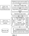
- the positioning method based on the edge cloud technology provided in the embodiment is implemented by the cooperation of the high-precision positioning platform on the public cloud server with the location calculation platform on the edge cloud server, and the system and module composition thereof is shown in FIG. 5 .
- the reference station network satellite observation data receiving module of the high-precision positioning platform is responsible for collecting respective satellite observation data packet of each station in the ground-based augmentation reference station network, calculating respective observation data of each reference station and transmitting the same to the differential correction model calculation module of the whole network.
- the whole network differential correction model calculation module divides the reference station network coverage area into grids, and generates respective differential correction model (including ionospheric and tropospheric models, etc.) of each grid based on the observation data of the reference station and the real coordinates thereof in the grid, and transmits the whole network differential correction model to the edge cloud service area matching module.
- a data broadcasting module is responsible for receiving a service area requirement uploaded by the location calculation platform of the edge cloud and transmitting the service area requirement to the service area matching module.
- the edge cloud service area matching module performs matching according to the edge cloud location service demand range and the grid area of the whole network, selects the grid correction data adjacent to the service area, calculates the differential correction model of a service demand area, and then transmits same to the data broadcasting module.
- the data broadcasting module sends the differential correction model of the service range required by the edge cloud to the edge cloud location calculation platform.
- the high-precision positioning platform may perform flexible match and calculation according to an actual location service area requirement of the edge cloud location calculation platform, thus improving the networking flexibility of the whole system.
- the area correction model acquiring module of the location calculation platform is responsible for uploading the required location service area to the high-precision positioning platform on the public cloud side, and acquiring the corresponding area correction model of the service demand area and transmitting the acquired area correction model to the terminal location calculation module.
- the terminal observation signal acquisition module is responsible for receiving a satellite signal observation value uploaded by the user terminal and then transmitting the received satellite signal observation value to the terminal location calculation module.
- the terminal location calculation module calculates the high-precision location information of the user terminal based on the area correction model and an original satellite observation signal of the user terminal, and then determines, according to a specific application requirement, whether to download the positioning information to the user terminal.
- Location calculation of the user terminal is performed at the location calculation platform on the edge cloud side, which may firstly reduce the physical transmission delay of acquiring the area differential correction model data from the high-precision platform on the public cloud server, and then may also ensure that the probability location of the user terminal is only transmitted in the edge cloud network, thus improving the privacy of users.
- the satellite signal receiving module is responsible for receiving a measurement satellite positioning and navigation signal
- the communication module is responsible for reporting the observation data to the location calculation platform on the edge cloud side and acquiring the positioning data.
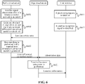
- FIG. 6 is a flowchart of a high-precision positioning method based on edge cloud technology according to an embodiment of the disclosure.
- the positioning system provided in the embodiment includes: a public cloud server, at least one edge cloud server and at least one user terminal.
- the number of public cloud servers, edge cloud servers and user terminals is not limited, and FIG. 6 is only an example.
- the public cloud server generates the differential correction model of the whole network according to the observation data of the reference station network, and generates the differential correction model of a target area according to a service demand area of the edge cloud server and transmits the area differential correction model to the edge cloud server.
- the edge cloud server performs high-precision location calculation on the user terminal according to the satellite signal observation value of the user terminal and the difference correction model of the target area. The detailed steps are shown in FIG. 6 .
- the high-precision positioning platform of the public cloud server receives the observation data of the reference station network; at S602, the high-precision platform divides the coverage area of the reference station network into a plurality of grids, and calculates respective differential correction model of each grid area; and at S603, the high-precision positioning platform matches the location service demand area uploaded by the edge cloud server with the grids, generates the differential correction model of the target area, and then transmits same back to the edge cloud server.
- the user terminal initiates a positioning request.
- the user terminal observes the satellite navigation signal and transmits an observation value to the edge cloud server.
- steps 601 (602, 603) and steps 611 (612) are independent of each other and processed in parallel, which can accordingly improve the flexibility of system networking and reduce the time delay for users to acquire location services.
- the edge cloud server calculates the high-precision location information of the user terminal, and transmits the high-precision location information back to the user terminal.
- the embodiments have the following beneficial effects.
- edge cloud server public cloud server, user terminal and system provided by the embodiment of the disclosure are introduced below, and the edge cloud server, public cloud server, user terminal and system described below may correspondingly refer to the user terminal positioning method described above.
- FIG. 7 is a structural schematic diagram of an edge cloud server according to an embodiment of the disclosure.
- the edge cloud server includes: a satellite positioning information receiving module 701, a location service area determination module 702, a differential correction model acquisition module 703, a location calculation module 704, and a location information sending module 705.
- the satellite positioning information receiving module 701 is configured to receive satellite positioning information from a user terminal.
- the location service area determination module 702 is configured to determine a location service area where the user terminal is located.
- the differential correction model acquisition module 703 is configured to acquire a differential correction model corresponding to the location service area from a public cloud server according to the location service area.
- the location calculation module 704 is configured to perform location calculation using the satellite positioning information and the differential correction model to obtain the location information of the user terminal.
- the location information sending module 705 is configured to send the location information to the user terminal.
- the differential correction model acquisition module 703 includes a location service area request sending unit and a differential correction model receiving unit.
- the location service area request sending unit is configured to send a location service area request corresponding to the location service area to the public cloud server.
- the differential correction model receiving unit is configured to receive a differential correction model corresponding to the location service area from the public cloud server.
- Modules in the edge cloud server provided in FIG. 7 have the functions of implementing steps in the example shown in FIG. 1 , and achieve the same technical effect as the user terminal positioning method shown in FIG. 1 , which are not repeated here, for briefness of description.
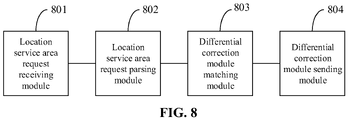
- the embodiments of the disclosure further provide a public cloud server.
- the public cloud server includes: a location service area request receiving module 801, a location service area request parsing module 802, a differential correction model matching model 803, and a differential correction model sending module 804.
- the location service area request receiving module 801 is configured to receive a location service area request from an edge cloud server.
- the location service area request parsing module 802 is configured to parse the location service area request and determine a location service area corresponding to the location service area request.
- the differential correction model matching model 803 is configured to match a differential correction model corresponding to the location service area according to the location service area.
- the differential correction model sending module 804 is configured to send the differential correction model to the edge cloud server for the edge cloud server to determine the location information of a user terminal according to the differential correction model.
- the public cloud server further includes: a satellite observation data packet receiving module, a satellite observation data packet parsing module, a coverage area division module, and a differential correction model determination module.
- the satellite observation data packet receiving module is configured to receive a satellite observation data packet from a ground-based augmentation reference station network.
- the satellite observation data packet parsing module is configured to parse a satellite observation data packet and acquire respective observation data of each reference station in the ground-based augmentation reference station network.
- the coverage area division module is configured to divide a coverage area of the ground-based augmentation reference station network to obtain a preset number of grid coverage areas.
- the differential correction model determination module is configured to determine a differential correction model of any grid coverage area according to the observation data and accurate location coordinates of the reference station in the grid coverage area.
- the differential correction model matching module 803 includes a grid coverage area determination unit and a differential correction model matching unit.
- the grid coverage area determination unit is configured to determine, based on the location service area, a grid coverage area to which the location service area belongs.
- the differential correction model matching unit is configured to match the differential correction model corresponding to the location service area according to the grid coverage area to which the location service area belongs.
- Modules in the public cloud server provided in FIG. 8 have the functions of implementing steps in the example shown in FIG. 2 , and achieve the same technical effect as the user terminal positioning method shown in FIG. 2 , which are not repeated here, for briefness of description.
- the embodiments of the disclosure further provide a user terminal.
- the user terminal includes a satellite positioning information receiving module 901 and a satellite positioning information sending module 902.
- the satellite positioning information receiving module 901 is configured to receive satellite positioning information from a satellite.
- the satellite positioning information sending module 902 is configured to send the satellite positioning information to an edge cloud server to acquire location information of the user terminal.
- Modules in the user terminal provided in FIG. 9 have the functions of implementing steps in the example shown in FIG. 3 , and achieve the same technical effect as the user terminal positioning method shown in FIG. 3 , which are not repeated here, for briefness of description.
- the embodiments of the disclosure further provide a user terminal positioning system.
- the user terminal positioning system includes an edge cloud server, a public cloud server and a user terminal.
- the edge cloud server is configured to execute the user terminal positioning method in the above embodiment.
- the public cloud server is configured to execute the user terminal positioning method in the above embodiment.
- the user terminal is configured to execute the user terminal positioning method in the above embodiment.
- the function block shown in the structure block diagram may be implemented as hardware, software, firmware, or a combination thereof.
- the function block may be, for example, an electronic circuit, an ASIC, and suitable firmware, plug-in, and functional card.
- the element of the disclosure is a program or code segment for executing a required task.
- the program or code segment may be stored in a machine-readable medium, or transmitted on a transmission medium or communication link by a data signal contained in a carrier.
- the "machine-readable medium” may include any medium capable of storing or transmitting information.
- Examples of the machine-readable medium include an electronic circuit, a semiconductor memory device, a ROM, a flash memory, an Erasable ROM (EROM), a floppy disk, a Compact Disc ROM (CD-ROM), an optical disk, a hard disk, an optical fiber medium, an RF link, etc.
- the code segment may be downloaded through a computer network, such as the Internet and an intranet.
- each module above is only logic function division, and the modules may be completely or partially integrated to a physical entity and may also be physically separated in actual implementation. And these modules may all be implemented in the form of software calling through processing elements and may all be implemented in the form of hardware. Also, partial modules may be implemented in the form of calling software by processing elements, and partial modules may be implemented in the form of hardware.
- the determination module may be a separate processing element, and may also be integrated to a certain chip in the above apparatus for implementation.
- the determination module may also be stored in a memory of the above apparatus in the form of a program code, and called by a certain processing unit in the above apparatus to execute the functions of the above determination module. Implementation of other modules is similar thereto.
- each module may completely or partially integrated together, and may also be independently implemented.
- the processing element herein may be an integrated circuit, and has a signal processing capability.
- each step of the method or each unit may be completed by means of instructions in the form of an integrated logic circuit of hardware in the processing element or software.
- each module, unit, sub-unit or sub-module may be one or more integrated circuits configured to implement the above method, such as one or more Application-Specific Integrated Circuits (ASICs), or, one or more Digital Signal Processors (DSPs), or, one or more Field-Programmable Gate Arrays (FPGAs).
- ASICs Application-Specific Integrated Circuits
- DSPs Digital Signal Processors
- FPGAs Field-Programmable Gate Arrays
- the processing element may be a generalpurpose processor, such as a Central Processing Unit (CPU) or other processors that may call the program code.
- CPU Central Processing Unit
- these modules may be integrated together and implemented in the form of System-On-a-Chip (SOC).
- SOC System-On-a-Chip
- a and/or B and/or C represents the following seven cases: A alone, B alone, C alone, both A and B exist, both B and C exist, both A and C exist, and A, B and C all exist.
- a and/or B and/or C represents the following seven cases: A alone, B alone, C alone, both A and B exist, both B and C exist, both A and C exist, and A, B and C all exist.
- the use of "at least one of A and B" in the specification and claims shall be understood as "A alone, B alone, or both A and B exist”.
Landscapes
- Engineering & Computer Science (AREA)
- Radar, Positioning & Navigation (AREA)
- Remote Sensing (AREA)
- Computer Networks & Wireless Communication (AREA)
- Physics & Mathematics (AREA)
- General Physics & Mathematics (AREA)
- Signal Processing (AREA)
- Position Fixing By Use Of Radio Waves (AREA)
Applications Claiming Priority (2)
| Application Number | Priority Date | Filing Date | Title |
|---|---|---|---|
| CN202010069444.6A CN113225360B (zh) | 2020-01-21 | 2020-01-21 | 用户终端定位方法、设备及系统 |
| PCT/CN2020/134914 WO2021147543A1 (zh) | 2020-01-21 | 2020-12-09 | 用户终端定位方法、设备及系统 |
Publications (2)
| Publication Number | Publication Date |
|---|---|
| EP4092985A1 true EP4092985A1 (de) | 2022-11-23 |
| EP4092985A4 EP4092985A4 (de) | 2024-02-28 |
Family
ID=76991807
Family Applications (1)
| Application Number | Title | Priority Date | Filing Date |
|---|---|---|---|
| EP20915919.3A Pending EP4092985A4 (de) | 2020-01-21 | 2020-12-09 | Positionierungsverfahren, -vorrichtung und -system für benutzerendgeräte |
Country Status (4)
| Country | Link |
|---|---|
| US (1) | US12282100B2 (de) |
| EP (1) | EP4092985A4 (de) |
| CN (1) | CN113225360B (de) |
| WO (1) | WO2021147543A1 (de) |
Families Citing this family (7)
| Publication number | Priority date | Publication date | Assignee | Title |
|---|---|---|---|---|
| CN114019585B (zh) * | 2021-10-11 | 2024-06-11 | 武汉大学 | 一种大高差地区高精度定位cors网fkp解算方法 |
| CN114327689B (zh) * | 2022-03-15 | 2022-07-12 | 浙江云针信息科技有限公司 | 一种面向复杂边缘计算环境的策略调度方法及系统 |
| CN117715178A (zh) * | 2022-09-09 | 2024-03-15 | 华为技术有限公司 | 卫星定位方法和相关产品 |
| CN115361438B (zh) * | 2022-10-19 | 2023-02-28 | 山东远联信息科技有限公司 | 一种面向云计算和大数据定位的业务处理方法和系统 |
| CN116879933A (zh) * | 2023-07-12 | 2023-10-13 | 银河航天(北京)网络技术有限公司 | 基于低轨卫星的定位方法、低轨卫星、定位系统及产品 |
| CN117098116B (zh) * | 2023-10-18 | 2023-12-26 | 湖北省国土测绘院 | 一种基于cors的gnss用户终端位置隐私保护方法 |
| CN118746848A (zh) * | 2024-06-21 | 2024-10-08 | 广东电网有限责任公司 | 定位无人机的卫星定位方法、装置、无人机终端和存储介质 |
Family Cites Families (29)
| Publication number | Priority date | Publication date | Assignee | Title |
|---|---|---|---|---|
| SG55053A1 (en) * | 1994-01-11 | 1998-12-21 | Erricsson Inc | Position registration for cellular satellite communication systems |
| CN101295014B (zh) | 2008-05-19 | 2011-01-05 | 中国测绘科学研究院 | 基于gnss的远距离高精度实时/快速定位方法和系统 |
| CN101299065A (zh) * | 2008-06-19 | 2008-11-05 | 宇龙计算机通信科技(深圳)有限公司 | 一种移动终端的定位方法及系统 |
| US8259008B2 (en) * | 2008-11-17 | 2012-09-04 | Qualcomm Incorporated | DGNSS correction for positioning |
| US8294573B2 (en) | 2008-12-11 | 2012-10-23 | International Business Machines Corporation | System and method for optimizing power consumption of container tracking devices through mesh networks |
| JP5392177B2 (ja) * | 2010-05-12 | 2014-01-22 | セイコーエプソン株式会社 | 電子機器 |
| CN103852773B (zh) * | 2012-11-30 | 2016-07-06 | 泰斗微电子科技有限公司 | 一种基于云计算技术的定位系统和定位方法 |
| CN103823228B (zh) * | 2014-01-29 | 2016-11-23 | 北京红旗胜利科技发展有限责任公司 | 定位系统、终端和定位方法 |
| EP3035080B1 (de) * | 2014-12-16 | 2022-08-31 | Trimble Inc. | Satellitennavigationssystem mit Positionierung mit Erzeugung von Korrektur-Informationen |
| CN105785410B (zh) * | 2014-12-25 | 2019-05-24 | 中国移动通信集团公司 | 一种提供位置信息的方法和系统 |
| CN104793219A (zh) * | 2015-01-15 | 2015-07-22 | 深圳市观复北斗航电仪器有限公司 | 卫星导航地面差分参考站及其系统 |
| CN104977596B (zh) * | 2015-06-08 | 2018-08-17 | 深圳北斗应用技术研究院有限公司 | 基于云计算的高精度位置修正定位系统 |
| CN106019336B (zh) * | 2015-08-28 | 2019-07-23 | 千寻位置网络有限公司 | 全球导航卫星系统的差分中继方法及其装置 |
| CN106569239B (zh) * | 2015-10-09 | 2019-08-23 | 唐颖哲 | 一种广播式网络rtk定位技术 |
| CN105334524B (zh) * | 2015-10-21 | 2018-06-05 | 山东天星北斗信息科技有限公司 | 一种基于虚拟网格的伪距差分定位方法 |
| CN108513248A (zh) * | 2017-02-24 | 2018-09-07 | 千寻位置网络有限公司 | 通信基站及其波束赋形方法 |
| CN107222468B (zh) * | 2017-05-22 | 2020-12-18 | 北京邮电大学 | 增强现实处理方法、终端、云端服务器和边缘服务器 |
| DE102017217017A1 (de) * | 2017-09-26 | 2019-03-28 | Robert Bosch Gmbh | Verfahren und Vorrichtung zum Bereitstellen von Korrekturdaten zur Satellitennavigation |
| CN107820204B (zh) * | 2017-10-23 | 2020-09-18 | 千寻位置网络有限公司 | 保护用户位置隐私的高精度定位方法及系统 |
| CN107872516A (zh) | 2017-10-23 | 2018-04-03 | 千寻位置网络有限公司 | 基于混合云的厘米级实时定位系统及实现方法 |
| CN107797127A (zh) | 2017-10-27 | 2018-03-13 | 千寻位置网络有限公司 | 高精度定位云端解算方法和系统 |
| CN109150818B (zh) * | 2017-12-25 | 2021-06-15 | 北极星云空间技术股份有限公司 | 分布式cors系统中的差分网格数据融合服务组件设计 |
| GB2571293A (en) * | 2018-02-22 | 2019-08-28 | Sageloc Ltd | System for providing location corrections |
| CN111090111A (zh) * | 2018-10-23 | 2020-05-01 | 千寻位置网络有限公司 | 基于边缘计算的动态差分定位方法及系统 |
| CN109951796B (zh) | 2019-03-07 | 2020-10-27 | 和芯星通科技(北京)有限公司 | 一种云+端的定位服务方法及系统 |
| CN110095797B (zh) * | 2019-05-28 | 2020-06-02 | 北京讯腾智慧科技股份有限公司 | 一种基于卫星导航系统的格网化精准定位服务方法和系统 |
| CN113050139B (zh) * | 2021-03-19 | 2023-09-29 | 交信北斗科技有限公司 | 基于格网化高精度卫星导航定位服务系统 |
| US11835633B1 (en) * | 2021-07-20 | 2023-12-05 | Spectrum Co, Llc | High power grid global navigation satellite systems corrections |
| CN113970773B (zh) * | 2021-10-29 | 2024-04-16 | 北京百度网讯科技有限公司 | 定位方法、装置及电子设备 |
-
2020
- 2020-01-21 CN CN202010069444.6A patent/CN113225360B/zh active Active
- 2020-12-09 WO PCT/CN2020/134914 patent/WO2021147543A1/zh not_active Ceased
- 2020-12-09 EP EP20915919.3A patent/EP4092985A4/de active Pending
- 2020-12-09 US US17/759,097 patent/US12282100B2/en active Active
Also Published As
| Publication number | Publication date |
|---|---|
| CN113225360A (zh) | 2021-08-06 |
| CN113225360B (zh) | 2023-04-18 |
| US12282100B2 (en) | 2025-04-22 |
| US20230041480A1 (en) | 2023-02-09 |
| EP4092985A4 (de) | 2024-02-28 |
| WO2021147543A1 (zh) | 2021-07-29 |
Similar Documents
| Publication | Publication Date | Title |
|---|---|---|
| US12282100B2 (en) | User terminal positioning method, device, and system | |
| US12127072B2 (en) | Positioning method and apparatus | |
| US20110009132A1 (en) | Positioning with several operators | |
| US20210109228A1 (en) | Identifying gnss navigation data as potentially manipulated or as trustworthy at least partially based on an estimated deviation of a second estimate of a satellite state from a first estimate of the satellite state | |
| EP2826315A1 (de) | Bestimmung von uhrenmodellen | |
| WO2022007901A1 (zh) | 一种云卡的分配方法、装置、电子设备及存储介质 | |
| US20210109229A1 (en) | Detection of gnss navigation data manipulation based on gnss system time differences | |
| EP1903349A1 (de) | Mobiles Kommunikationsendgerät zum Empfangen von Standortinformationen und Verfahren dafür | |
| EP2175291A2 (de) | Verfahren und System für individuell mit Standard-AGPS-Netzwerkvorrichtungen angepasste volle Ephemeriden | |
| EP3001621B1 (de) | Verfahren und vorrichtung zur signaldemodulation durch verwendung von geschwindigkeitsvektoren in einem mobilen endgerät | |
| CN115993623B (zh) | 一种自适应选星方法、装置、设备及可读存储介质 | |
| WO2020084888A1 (ja) | サーバ、衛星測位システム、及び、衛星測位方法 | |
| CN113316182A (zh) | 信息传输方法及装置 | |
| CN117793623A (zh) | 一种多重融合定位方法、系统、设备及介质 | |
| CN114814906B (zh) | 单频定位方法、装置、接收机设备及计算机可读存储介质 | |
| CN119816759A (zh) | 一种定位方法和装置 | |
| CN107843909B (zh) | 基于rtk的定位方法、系统及装置 | |
| US20140256354A1 (en) | Mobile broadband device and assisted positioning method therefor | |
| CN111123319B (zh) | 一种卫星定位装置、卫星信号接收机及终端设备 | |
| CN111158033B (zh) | 基于gnss的差分定位方法、装置、设备和存储介质 | |
| CN112200279A (zh) | 一种终端定位方法、系统、存储介质及电子设备 | |
| CN109150922A (zh) | 一种基于cors系统的gnss终端差分服务认证方法 | |
| CN114035203A (zh) | 伪距信号的发送方法、装置、存储介质及电子装置 | |
| EP3644096B1 (de) | Funkkarten für ortungs- und/oder positionierungsdienste | |
| CN111381261B (zh) | 一种定位解算方法、装置及卫星导航接收机 |
Legal Events
| Date | Code | Title | Description |
|---|---|---|---|
| STAA | Information on the status of an ep patent application or granted ep patent |
Free format text: STATUS: THE INTERNATIONAL PUBLICATION HAS BEEN MADE |
|
| PUAI | Public reference made under article 153(3) epc to a published international application that has entered the european phase |
Free format text: ORIGINAL CODE: 0009012 |
|
| STAA | Information on the status of an ep patent application or granted ep patent |
Free format text: STATUS: REQUEST FOR EXAMINATION WAS MADE |
|
| 17P | Request for examination filed |
Effective date: 20220819 |
|
| AK | Designated contracting states |
Kind code of ref document: A1 Designated state(s): AL AT BE BG CH CY CZ DE DK EE ES FI FR GB GR HR HU IE IS IT LI LT LU LV MC MK MT NL NO PL PT RO RS SE SI SK SM TR |
|
| DAV | Request for validation of the european patent (deleted) | ||
| DAX | Request for extension of the european patent (deleted) | ||
| REG | Reference to a national code |
Ref country code: DE Ref legal event code: R079 Free format text: PREVIOUS MAIN CLASS: H04L0029080000 Ipc: H04L0067520000 |
|
| A4 | Supplementary search report drawn up and despatched |
Effective date: 20240126 |
|
| RIC1 | Information provided on ipc code assigned before grant |
Ipc: H04L 67/52 20220101AFI20240122BHEP |
|
| RIC1 | Information provided on ipc code assigned before grant |
Ipc: H04L 67/52 20220101AFI20250602BHEP |
|
| STAA | Information on the status of an ep patent application or granted ep patent |
Free format text: STATUS: EXAMINATION IS IN PROGRESS |
|
| 17Q | First examination report despatched |
Effective date: 20250714 |
|
| GRAP | Despatch of communication of intention to grant a patent |
Free format text: ORIGINAL CODE: EPIDOSNIGR1 |
|
| STAA | Information on the status of an ep patent application or granted ep patent |
Free format text: STATUS: GRANT OF PATENT IS INTENDED |