EP4116676B1 - Horizon électronique pour fonction adas - Google Patents
Horizon électronique pour fonction adas Download PDFInfo
- Publication number
- EP4116676B1 EP4116676B1 EP21184886.6A EP21184886A EP4116676B1 EP 4116676 B1 EP4116676 B1 EP 4116676B1 EP 21184886 A EP21184886 A EP 21184886A EP 4116676 B1 EP4116676 B1 EP 4116676B1
- Authority
- EP
- European Patent Office
- Prior art keywords
- electronic horizon
- mobile device
- server
- data
- information
- Prior art date
- Legal status (The legal status is an assumption and is not a legal conclusion. Google has not performed a legal analysis and makes no representation as to the accuracy of the status listed.)
- Active
Links
Images



Classifications
-
- G—PHYSICS
- G01—MEASURING; TESTING
- G01C—MEASURING DISTANCES, LEVELS OR BEARINGS; SURVEYING; NAVIGATION; GYROSCOPIC INSTRUMENTS; PHOTOGRAMMETRY OR VIDEOGRAMMETRY
- G01C21/00—Navigation; Navigational instruments not provided for in groups G01C1/00 - G01C19/00
- G01C21/26—Navigation; Navigational instruments not provided for in groups G01C1/00 - G01C19/00 specially adapted for navigation in a road network
- G01C21/34—Route searching; Route guidance
- G01C21/3407—Route searching; Route guidance specially adapted for specific applications
-
- G—PHYSICS
- G01—MEASURING; TESTING
- G01C—MEASURING DISTANCES, LEVELS OR BEARINGS; SURVEYING; NAVIGATION; GYROSCOPIC INSTRUMENTS; PHOTOGRAMMETRY OR VIDEOGRAMMETRY
- G01C21/00—Navigation; Navigational instruments not provided for in groups G01C1/00 - G01C19/00
- G01C21/26—Navigation; Navigational instruments not provided for in groups G01C1/00 - G01C19/00 specially adapted for navigation in a road network
- G01C21/34—Route searching; Route guidance
- G01C21/36—Input/output arrangements for on-board computers
- G01C21/3605—Destination input or retrieval
- G01C21/3617—Destination input or retrieval using user history, behaviour, conditions or preferences, e.g. predicted or inferred from previous use or current movement
-
- G—PHYSICS
- G01—MEASURING; TESTING
- G01C—MEASURING DISTANCES, LEVELS OR BEARINGS; SURVEYING; NAVIGATION; GYROSCOPIC INSTRUMENTS; PHOTOGRAMMETRY OR VIDEOGRAMMETRY
- G01C21/00—Navigation; Navigational instruments not provided for in groups G01C1/00 - G01C19/00
- G01C21/38—Electronic maps specially adapted for navigation; Updating thereof
- G01C21/3804—Creation or updating of map data
- G01C21/3807—Creation or updating of map data characterised by the type of data
- G01C21/3815—Road data
-
- G—PHYSICS
- G01—MEASURING; TESTING
- G01C—MEASURING DISTANCES, LEVELS OR BEARINGS; SURVEYING; NAVIGATION; GYROSCOPIC INSTRUMENTS; PHOTOGRAMMETRY OR VIDEOGRAMMETRY
- G01C21/00—Navigation; Navigational instruments not provided for in groups G01C1/00 - G01C19/00
- G01C21/38—Electronic maps specially adapted for navigation; Updating thereof
- G01C21/3885—Transmission of map data to client devices; Reception of map data by client devices
- G01C21/3889—Transmission of selected map data, e.g. depending on route
Definitions
- the present disclosure pertains to the concept of electronic horizons and to the provision of advanced driver assistance systems (ADAS), such as an intelligent speed assistance (ISA).
- ADAS advanced driver assistance systems
- ISA intelligent speed assistance
- ADAS function is an intelligent speed assistance (ISA), which can be considered an advanced safety feature that prevents vehicles from exceeding the set speed limit helping to reduce collisions on roads.
- ISA intelligent speed assistance
- OEMs vehicle manufacturers
- other automotive providers require cost effective hardware components, which often end up with very limited data processing and storage capabilities.
- map data which is employed for this purpose, speed limits and other signs posted adjacent to roads are usually recorded as map objects, with their locations stored either in coordinate point format (WGS-84) or in relation to the road link (e.g. with a Link ID and an offset along that link).
- ADAS systems can then rely on map information that provides the relevant speed limit for the section of the road where the vehicle is currently located.
- the required data for the respective ADAS function may then be retrieved from the onboard map - assuming the data remains updated regularly. Updates to the map would need to be pushed over the air (i.e. over a wireless data connection) or via USB/SD cards.
- Information related to ADAS functions, such as the speed limit and other features which may aid in speed limit detection are then updated as part of a map tile or region update.
- the storage of a complete map database and the retrieval of the information of interest e.g. the speed limit information and possibly auxiliary location information to aid the on-vehicle camera-based speed limit detection for an ISA
- the information of interest e.g. the speed limit information and possibly auxiliary location information to aid the on-vehicle camera-based speed limit detection for an ISA
- map data For vehicles without an onboard map, such map data would need to be retrieved via an online connection, e.g. after providing the vehicle position to a server.
- a map tile or an individual map layer could be provided in response, either via a map update or streaming, containing the required information (e.g. location of speed limits) for the respective tiled portion of the map.
- the required information e.g. location of speed limits
- a tile would therefore usually contain both relevant and irrelevant features for supporting an ISA.
- the tile would often contain features of roads irrelevant to the vehicle path.
- data connections may not always be available, it may not even be possible to reach and query the remote server for respective map data in order to then extract the information of interest, such as speed limit and other posted sign information.
- the present disclosure thus inter alia addresses the problem of how to provide information required for certain ADAS functions (such as speed limit information for an ISA function) to vehicles with limited processing resources and - in particular - without a local map database.
- the present disclosure also addresses the problem of limited network coverage and limited network transfer for providing information required for ADAS functions via an online connection.
- the present disclosure also provides an improved data protection.
- a method, performed by a mobile device or a part thereof, is disclosed, as defined in claim 1.
- the mobile device performing the method of the first aspect may for instance be a vehicle, a car, a motor bike or the like.
- the mobile device or the part thereof may also be a navigation system integrated into a vehicle.
- the mobile device may also be a smartphone, for instance.
- a part of the mobile device may for instance be a software and/or hardware component of the aforementioned entities, such as a functional component, a client component, a module, a circuitry, a chip, a microprocessor or the like.
- a method, performed by a server or a part thereof, is disclosed, as defined in claim 13.
- the at least one server performing the method according to the second aspect may for instance be or comprise a server of a map provider or distributor.
- the at least one server may also be realized by multiple servers or a distributed architecture and may for instance be or comprise a distributed server, a network edge server, or a cloud server.
- the server may also comprise a database (e.g. a map database) or be in communication with an (e.g. external) database or a database server.
- a part of the server may for instance be a software and/or hardware component thereof, such as a functional component, a server component, module, a circuitry, a chip, a microprocessor or the like.
- the mobile device or part thereof performing the method of the first aspect and the at least one server performing the method of the second aspect may work together to perform embodiments of the methods of the first and/or second aspects.
- the computer program product may be stored on computer-readable storage medium, in particular a tangible and/or non-transitory medium.
- the computer readable storage medium could for example be a disk or a memory or the like.
- the computer program product could be stored in the computer readable storage medium in the form of instructions encoding the computer-readable storage medium.
- the computer readable storage medium may be intended for taking part in the operation of a device, like an internal or external memory, for instance a Read-Only Memory (ROM) or hard disk of a computer, or be intended for distribution of the program, like an optical disc.
- ROM Read-Only Memory
- an apparatus i.e. a mobile device or a part thereof/a server or a part thereof
- a mobile device configured to perform and/or control or comprising respective means for performing and/or controlling the method according to the respective exemplary aspect of the present invention.
- the means of the respective apparatus of any aspect can be implemented in hardware and/or software. They may comprise for instance at least one processor for executing computer program code for performing the required functions, at least one memory storing the program code, or both. Alternatively, they could comprise for instance circuitry that is designed to implement the required functions, for instance implemented in a chipset or a chip, like an integrated circuit. In general, the means may comprise for instance one or more processing means or processors.
- a respective apparatus i.e. a mobile device or a part thereof/a server or a part thereof
- a respective apparatus comprising at least one processor and at least one memory including computer program code, the at least one memory and the computer program code configured to, with the at least one processor, cause an apparatus at least to perform and/or to control the method according to the respective exemplary aspect of the present invention.
- the above-disclosed apparatus may be a module or a component for a device, for example a chip.
- the disclosed apparatus may comprise only the disclosed components, for instance means, processor, memory, or may further comprise one or more additional components.
- a system comprising a mobile device or a part thereof and a server or a part thereof together performing the method according to the first and/or second exemplary aspect.
- the mobile device or a part thereof may be configured to perform the method according to the first exemplary aspect and the server or a part thereof may be configured to perform the method according to the second exemplary aspect.
- a wireless communications network such as a cellular communication system (e.g. a communication system utilizing GSM, WCDMA, LTE, 5G and/or any future generation technology) and/or a non-cellular communication system (e.g. a wireless local area network).
- a cellular communication system may for instance be characterized by a basically seamless pavement of a geographical area (usually in the order of at least hundreds or thousands of square kilometers) with cells in which coverage is provided by respective nodes of the communication system that are operated by the same operator, which network may for instance support communication handover between cells.
- a non-cellular communication system may be characterized as a communication system that does not have all of these properties.
- examples of a cellular communication system or network are a second generation (2G, for instance the Global System for Mobile Communication (GSM), the General Packet Radio System (GPRS), the Enhanced Data Rates for GSM Evolution (EDGE) or the High Speed Circuit-Switched Data (HSCSD)), third generation (3G, for instance the Universal Mobile Telecommunication System, UMTS, WCDMA, TD-SCDMA or CDMA-2000), fourth generation (4G, for instance the Long Term Evolution, LTE system, the LTE Advanced (LTE-A) system or the IEEE 802.16m WiMAX system), fifth generation (5G) or newer communication system or network.
- GSM Global System for Mobile Communication
- GPRS General Packet Radio System
- EDGE Enhanced Data Rates for GSM Evolution
- HCSD High Speed Circuit-Switched Data
- third generation for instance the Universal Mobile Telecommunication System, UMTS, WCDMA,
- Non-cellular communication system or network examples include a WLAN (e.g. a WiFi or IEEE 802.11) system, a WiMAX (e.g. a IEEE 802.16) system, a Satellite Internet Access system, Bluetooth (LE) system, a ZigBee system, a radio-frequency identification (RFID) system, a broadcasting network such as for instance Digital Video Broadcasting (DVB), Digital Audio Broadcasting (DAB) or Frequency-Modulated (FM) / Amplitude-Modulated (AM) system, a Near Field Communication (NFC) system, etc.
- WLAN e.g. a WiFi or IEEE 802.11
- WiMAX e.g. a IEEE 802.16
- Satellite Internet Access system e.g. a satellite Internet Access system
- Bluetooth e.g., a ZigBee system
- RFID radio-frequency identification
- broadcasting network such as for instance Digital Video Broadcasting (DVB), Digital Audio Broadcasting (DAB) or Frequency-Modulated (FM)
- An advanced driver assistance system (ADAS) function may generally be understood as an electronic technology for assisting a driver in e.g. driving and/or parking.
- an ADAS may make use of a human-machine interface.
- An ADAS may use sensors (e.g. cameras), to detect nearby obstacles or driver errors, and respond accordingly.
- An ADAS function may for instance alert the driver to problems, implement safeguards, and/or take control of the vehicle if necessary.
- an ADAS function may provide speed limit assistance, automate lighting, adaptive cruise control, assist in avoiding collisions, incorporate satellite navigation and traffic warnings, alert drivers to possible obstacles, assist in lane departure and lane centering, provide navigational assistance through smartphones, to name a few examples.
- this function may for instance use information about the road or road side objects to determine an allowed or adequate speed, as will be explained in further detail below.
- the ISA function is understood only as an example of a possible ADAS function for the present invention.
- An electronic horizon may for instance refer to a partial representation of a traffic or road network.
- an electronic horizon may for instance comprise data on one or more road links or segments, intersections, road side objects, road geometry and/or attributes of roads or road objects.
- the representation of the traffic network may lead out from a current position of the mobile device e.g. to a certain limited (e.g. predicted depending on the specific circumstances) extent.
- the electronic horizon may represent the traffic network (e.g. road(s), attributes etc.) ahead of (or possibly behind) the mobile device.
- the electronic horizon may be representation of potential paths to be taken by the mobile device from its current position in the near future.
- the electronic horizon may be understood to refer to a collection of data representing a partial traffic network leading away from the current position of the mobile device to a limited extent and thereby forming the electronic horizon.
- the electronic horizon comprises data derived from map data about a portion of the traffic network ahead, which can then be used by a respective ADAS applications to implement the corresponding ADAS functionality with respect to the mobile device.
- the construction of the electronic horizon involves predicting the path or paths that the mobile device is likely to travel in the immediate future. This ensures that the necessary data is transmitted over to the mobile device to allow implementation of the respective ADAS function by the mobile device as it travels.
- the server may balance the provision of sufficient data to ensure that ADAS functionality may be adequately implemented by mobile device while avoiding overloading the mobile device and its ADAS applications.
- the determination of the size or extent of the electronic horizon to be constructed by the server may be data size driven. This may in particular allow for maintaining an optimal cache utilization (e.g. by delivering paths of lengths potentially crossing multiple tiles). Accordingly, the requests for obtaining an electronic horizon at the mobile device may be made at irregular intervals, which irregular may in particular provide a better privacy protection. This is in contrast to an approach, where the extent of each obtained electronic horizon is based on and in particular limited to the edge of a respective tile (meaning that there has to be at least one request per tile), which requests may allow to draw conclusions on the identity which may be a privacy protection issue.
- the described approach on the other hand may advantageously work on the basis of a path rather than a tile.
- the path can be dynamically scaled (i.e. shortened or prolonged), depending on various factors such as speed, available cache, expected connectivity, strategy to minimize data transfer cost etc (as will be described in more detail below).
- the requests can be managed without keeping state server-side, which 1) simplifies the implementation, 2) saves resources and 3) lowers the privacy risk of storing location data.
- the payload size of the electronic horizon can be tuned to fit on a fixed number of cell data packages (ideally, only on one), so that there is less communication overhead when providing the electronic horizon data.
- TCP has a maximum payload size of 64 kb, which could span several tiles (particularly on a highway away from population centers).
- the extent of the electronic horizon may be subject to further considerations as will be explained in more detail below.
- an electronic horizon covers one or more potential paths predicted to be taken an electronic horizon can be obtained which extends farther than it is currently needed by the respective ADAS applications, so data can be delivered to the ADAS applications for some time from a single electronic horizon data set from the server. This applies both when an ADAS application needs information just for the current location, or when it itself needs an electronic horizon (in the latter case the electronic horizon provided to the ADAS applications may be less extended than the one obtained from the server). Moreover, it is not necessary, to deliver the electronic horizon incrementally, continuously updating it with additional data relevant at the current position, rather a one-time sending (even though repeatedly) of a full electronic horizon (with more data than needed right now) can be done.
- the electronic horizon has been constructed from map data by the server specifically for enabling the mobile device to provide the respective ADAS function(s) or to at least for supporting the mobile device in providing the respective ADAS function(s).
- the electronic horizon may be considered to be specifically constructed for a certain situation or circumstances (e.g. based on a certain position of the mobile device, a certain potential paths predicted to be taken by the mobile device and/or certain ADAS function(s) to be provided).
- an electronic horizon may be considered to be dependent on the current position of the mobile device, the path(s) predicted to be taken by the mobile device and/or the ADAS function(s) to be supported by the electronic horizon.
- an electronic horizon is constructed or derived from this map data by the server.
- the data of the electronic horizon has already been extracted from this map data, so that only data specifically relevant or required for the respective ADAS function(s) maybe included in the electronic horizon.
- the electronic horizon may comprise less data than for instance the original map with the same geographic extent.
- ADASIS ADASIS version 1, version 2 or version 3
- specific implementation and data structure of the electronic horizon is not limited by the present disclosure.
- a current position such as a current car position CCP, the heading and speed of the mobile device, the local time etc.
- a current position such as a current car position CCP, the heading and speed of the mobile device, the local time etc.
- a certain number of the last position estimates may be considered, as will be explained in more detail below.
- other information such as expectations based on previously taken paths of mobile entities at the same position may be considered.
- the method according to the first and/or second aspect may further comprise the step of predicting one or more potential paths, which are likely to be taken by the mobile device so that the electronic horizon data can then cover the one or more potential paths. For instance, only paths which are taken with a probability above a (e.g. predefined or dynamically calculated) threshold may be considered. For instance, the electronic horizon may cover the most probably path and sub-paths, e.g. as long as they are above the threshold. For instance, only potential paths up to a (e.g. predetermined) maximum distance, radius and/or expected travel time from a current position of the mobile device may be used for the electronic horizon.
- a threshold e.g. predefined or dynamically calculated
- an ADAS performed by the mobile device may be based solely on the data from the electronic horizon
- an ADAS function typically considers further data, such as sensor inputs from the mobile device, as will be explained in more detail below. Accordingly, the ADAS functions(s) may at least partially be based on the electronic horizon.
- the mobile device determines that it is close to a border of the electronic horizon it may request a new or replacement electronic horizon.
- the server determines that the mobile device should be close to a border of the electronic horizon it may push a new or replacement electronic horizon to the mobile device.
- the electronic horizon only comprises electronic horizon data required and/or useful specifically for the one or more ADAS functions.
- the electronic horizon may not comprise electronic horizon data which may only be useful for other ADAS functions.
- the electronic horizon data may not comprise electronic horizon data which is not essential, required and/or not useful for the one or more ADAS functions.
- the electronic horizon comprises electronic horizon data only for one, two or three different ADAS functions.
- the all of the electronic horizon data of the electronic horizon may be required and/or useful for one ADAS function.
- the electronic horizon may be provided by a server specifically dedicated for providing an electronic horizon constructed for this ADAS function.
- the electronic horizon data shall enable or support an intelligent speed assistance function of a mobile device
- the electronic horizon may be provided by a speed limit online (SLO) server.
- SLO speed limit online
- the construction of the electronic horizon by the server may also comprise the steps of identifying one or more ADAS functions which shall be supported by the electronic horizon and then constructing the electronic horizon based on these one or more identified ADAS functions.
- the electronic horizon data comprises reduced road geometry information.
- Reduced road geometry information may in particular refer to reduced road geometry information compared to road geometry information which is comprised by the map data from which the electronic horizon is constructed.
- the electronic horizon data may not comprise a precise representation of the road geometry.
- the electronic horizon data may in particular not comprise one or more of the following road geometry information: latitude/longitude information of every point, a spline representation, a clothoid representation and/or a curve based representation of a road or road segment.
- the electronic horizon data may only comprise a linear road segments or links with information about the length of the individual links or segments but with no road geometry for the individual road links or segments.
- the electronic horizon data may however comprise speed limit information for the individual road links or segments.
- a reduced road geometry may make a matching of the position of the mobile device with respect to the electronic horizon more difficult or less precise, it may still reduce the required processing power, in particular in case the reduced road geometry is made up for or balanced by considering other information instead, such as data obtained from sensor of the mobile device, as will be explained in more detail below.
- the method according to the first exemplary aspect may further comprise:
- an internal (or local) electronic horizon may be constructed comprising a subset of the electronic horizon data comprised by the obtained electronic horizon (which may thus in contrast be considered as an "external", “cloud-based” or “remote” electronic horizon).
- the internal or local electronic horizon is only used for distributing data (from the obtained electronic horizon) internally or locally in the mobile device. This may further facilitate the distribution of the obtained electronic horizon to the respective components or modules in the mobile device.
- the mobile device may comprise a client component for receiving the electronic horizon and for constructing an internal electronic horizon in order to forward the electronic horizon data of the received electronic horizon (or a part thereof) to further components in the mobile device, e.g.
- Forwarding or providing the internal electronic horizon can be done in multiple ways, e.g. providing a proprietary API inside the mobile device (e.g. the ECU) or distributing it via a standard protocol like ADASISv2.
- the method according to the first exemplary aspect may further comprise:
- the sensors used for performing the ADAS function may depend on the specific ADAS function to be performed.
- a sensor of the mobile device may be a camera.
- a camera may be useful for performing an ISA function, as the camera may detect roadside signs (directly or indirectly) providing information about the currently valid speed limit to observe.
- other sensors such as an accelerometer, a gyroscope, an odometer, or various other sensors typically used and implemented in vehicles, may be used depending on the specific use case or ADAS function to be implemented.
- the obtained sensor data and the electronic horizon data (e.g. by means of the obtained electronic horizon or as a locally constructed internal electronic horizon) may be provided to a fusion component of the mobile device, which may then fuse or combine the electronic horizon data and the sensor data for providing the ADAS function (or data required therefore).
- the one or more ADAS functions comprise one or more of:
- an intelligent speed assistance (ISA) function may for instance use information about the road or roadside objects to determine an allowed or adequate speed. For instance, information can be obtained from knowledge of the position of the mobile device (with respect to the electronic horizon), taking into account speed limits known for the position, and/or by interpreting road features such as signs (respective data being obtained e.g. from sensor).
- an ISA may 1) inform the driver about the current speed limit, 2) alert the driver in case of overspeeding, and/or 3) assist the driver/car to stay below the speed limit by actively adjusting the vehicle speed (with in particular actions 2) and 3) being optional, while 1 is typically a mandatory implementation).
- an ISA may alert a driver (passive ISA, e.g.
- an ISA may provide information about driving hazards (e.g. high pedestrian movement areas, railway crossings, schools, hospitals, etc.) and limits enforced by e.g. radar or speed cameras.
- the method according to the first aspect may in particular comprise a respective method step of e.g. alerting the driver and or adapt the speed of the mobile device.
- the purpose of an ISA is to assist the driver to maintain a safe speed.
- a hazard warning function may indicate different in particular temporary and/or local hazards to the driver and/or actively engage into a driving functionality of the vehicle. Examples of such hazards are an accident, a flooding, a traffic jam, a road closure for instance.
- ADAS function may be an emergency vehicle indication function, which may indicate to the driver that an emergency vehicle is approaching and/or actively engage into a driving functionality of the vehicle, so that a corridor for an emergency vehicle can be formed.
- a traffic sign detection or recognition (TSR) function can recognize common traffic signs, such as a "stop” sign or a "turn ahead” sign, through image processing techniques (e.g. based on the sign's shape or color). Due to the use of camera-based technology, various factors (poor lighting, weather conditions, partial obstruction of the sign) can make the optical TSR less accurate.
- a traffic sign detection may also form part of the ISA function (e.g. as one input to a fusion component for merging the data with the electronic horizon data).
- V2V Vehicle-to-Vehicle
- V2I Vehicle-to-Infrastructure
- V2X Vehicle-to-Everything
- V2V systems allow vehicles to exchange information with each other about their current position and upcoming hazards (which may in particular be advantageous for the hazard warning function or emergency vehicle approaching function).
- V2I systems occur when the vehicle exchanges information with nearby infrastructure elements, such as street signs (which may in particular be advantageous for the traffic sign recognition or the intelligent speed assistance).
- V2X systems occur when the vehicle monitors its environment and takes in information about possible obstacles or pedestrians in its path.
- one or more of the following information is comprised by or derivable from the electronic horizon data:
- the above information is in particular helpful if the electronic horizon has at least been constructed for the ADAS function of an intelligent speed assistance.
- a country code information may be important as it provides for expected road sign characteristics to perform a detection, as e.g. speed limit signs differ slightly between countries. Also, a country code may provide information for implicit speed limits (e.g. a city entrance or exit sign may imply certain speed limits).
- Information on a type of road may refer to the category of road (e.g. Freeway, Highway, Local Road, etc.), which may also provide an indication of the expected size and position for the posted sign limits, especially in connection with the country code, and/or implicit speed limits applying to the road.
- category of road e.g. Freeway, Highway, Local Road, etc.
- Information on a side of driving i.e. a right or left hand drive attribute
- a side of driving provides an indication of for the mobile device to expect relevant (e.g. speed limit) signs on one side or the other.
- relevant e.g. speed limit
- the mobile device may only look for or detect signs on the right hand side and vice versa.
- this information may also be implied or derivable from the country code, for instance.
- Information on a distance to an intersection may provide additional information on where (along the road) or when to expect or search for (e.g. speed limits) signs, while information on the number of lanes in and/or opposite the driving direction may aid in an estimation of a lateral distance (i.e. transverse to the road) from the vehicle to the (e.g. speed limit) sign.
- An indication of an urban area may allow to derive further configurations or constrains to be considered e.g. for the detection of road signs, and which may require a detection algorithm to operate e.g. in a different manner or mode, e.g. employing a different segmentation of captured images than e.g. compared to in the open road.
- vehicle e.g. a fusion component
- vehicle sensors such as a camera
- the method according to the first exemplary aspect may further comprise one or more of:
- the indication of the trajectory comprises one or more position estimates heading information and/or speed information of the mobile device, and/or the indication of the trajectory is provided in response to determining that the electronic horizon needs to be updated.
- the mobile device may repeatedly check whether the electronic horizon needs to be updated. For this, the mobile device may determine its geographic position (e.g. by means of satellite positioning and/or sensors, such as odometer, gyroscope, accelerometer, etc.) and compare it identify this position in or with respect to the electronic horizon. As a result of this checking it may be determined that an update is required. For instance, in case the position is close (e.g. below a predefined threshold) to a border of the electronic horizon, the mobile device may determine that an update is required and may request an update of the electronic horizon.
- the mobile device may determine that an update is required and may request an update of the electronic horizon.
- the it may be decided whether the electronic horizon may need to be updated by defining a first or minimum electronic horizon extent or extension (in particular ahead of the vehicle, e.g. in distance or time units) and a second or desired electronic horizon extent or extension (in distance or time units) and by applying the following scheme: If the actual remaining extension (e.g. distance or time from current position to border of electronic horizon) becomes less than or equal to a pre-defined minimum extension, it is determined that the electronic horizon needs to be updated or replaced, and the new electronic horizon is then created (at least) with the desired extension and provided as an (incremental) update or a replacement electronic horizon.
- the extent may also be larger, e.g. because connectivity gaps may need to be avoided as described in more detail below.
- the mobile device may not be able to match its position to any feature of the current electronic horizon
- the mobile device may also be a reason to request a new electronic horizon.
- other events or circumstance which may demand an update of the electronic horizon are also possible.
- the mobile device may provide, to the server, one or more position estimates of the mobile device.
- the mobile device may provide the last n position estimates (e.g. the last 1, 2, 3 4 or 5 position estimates), which may for instance comprise latitude and longitude information. In case more than one position estimate is provided this may allow the server to also determine a heading and/or speed of the mobile device. Additionally or alternatively, the position estimate(s) may also directly comprise speed information and/or a heading information.
- positioning information of the mobile device may be useful for two different purpose.
- the positioning information may be used as (or together with other information, such as heading and/or speed information as apart of) the trajectory information in order to be sent to the server (e.g. when the position is or is about to be outside of the electronic horizon).
- the server e.g. when the position is or is about to be outside of the electronic horizon.
- a map matching can be done and an electronic horizon can be constructed, as described.
- positioning information can be done (e.g. regularly) at the mobile device based on the already obtained electronic horizon.
- the mobile device may for instance comprise a client component and a fusion component.
- the fusion component may for instance require information to be used for at least one of the one or more ADAS functions and may thus send a corresponding request to the client component, which in turns receives the request (for instance, the fusion component may send a request for speed limit information to the client component).
- the client component may actively provide this information to the fusion component (or generally within the mobile device), e.g. via the local or internal electronic horizon.
- the mobile device e.g. a client component
- the mobile device may identify a position of the mobile device with respect to the electronic horizon (i.e. an electronic horizon based map match).
- the mobile device may determine and/or provide information to be used for at least one of the one or more ADAS functions based on the electronic horizon. For instance, based on the identified position of the mobile device with respect to the electronic horizon, the mobile device (e.g. the client component) may determine and then provide information of the electronic horizon relevant for the relevant ADAS function (e.g. to the fusion component).
- the distribution or provision of the information to be used for the ADAS function(s) may in one example, as already mentioned, use an internal electronic horizon which is constructed (e.g. by the client component) based on the obtained electronic horizon and then this internal electronic horizon is transmitted internally within the mobile device (e.g. to the fusion component).
- an extent of the electronic horizon takes into account an expected availability of a network connectivity between the mobile device and the server.
- the server determines an extent of the electronic horizon at least in part based on an expected availability of a network connectivity between the mobile device and the server, wherein said constructing of said electronic horizon is then at least in part based on said determined extent.
- network coverage or connectivity information such as a connectivity map
- an extent may be understood as a geographic extent covered by the electronic horizon data.
- the (geographical) extent of the electronic horizon may be chosen such that the border of the electronic horizon is not located in an area with a connectivity gap.
- the network connectivity or gap may be specific to a certain service provider used by the mobile device for a connection to the server (e.g. a specific provider chosen by a car maker).
- the network service provider may be considered as a parameter and in particular also provided to the server for consideration when constructing the electronic horizon.
- a connectivity gap may be understood to be an area with no, low and/or slow connectivity (e.g. reception and/or bandwidth below a threshold).
- the electronic horizon covers one or more potential paths predicted to be taken by the mobile device. For instance, these predicted paths may be chosen such (e.g. sufficiently long) that connectivity gaps are avoided when the mobile device requires an updated electronic horizon. For instance, this aspect may be taken into account by the server when constructing the respective electronic horizon.
- network coverage information may be used in order to determine, whether there is the risk that an updated electronic horizon will need to be updated in a connectivity gap. For instance, it may be avoided that at least the most probably path (MPP) covered by electronic horizon ends in an area of a connectivity gap. Additionally or alternatively, this aspect may also be considered by the mobile device when requesting an electronic horizon (e.g. in case the mobile device is allowed to indicate a desired extent of the electronic horizon with the request).
- MPP most probably path
- the method according to the first exemplary aspect, for identifying a position of the mobile device with respect to the electronic horizon, may further comprise one or more of:
- the electronic horizon data may in particular comprise reduced road geometry information.
- further information of sensors of the mobile device may be utilized. For instance, a distance traveled by the mobile device from a position for which an indication of a trajectory of the mobile device was provided to the server may be determined (e.g. by means of an odometer and/or wheel rotation information) and then used to identify a position of the mobile device with respect to the electronic horizon.
- the indication of a trajectory may in particular comprise a position estimate indicating a respective position, as already mentioned.
- heading information or heading change information of the mobile device may be determined (e.g.by means of a gyroscope and/or an accelerometer) and then used to identify a position of the mobile device with respect to the electronic horizon.
- measured heading or heading change information of the mobile device can be compared to (expected) heading or heading change information in the electronic horizon.
- the comparison between heading (change) information in the electronic horizon and the heading (change) information registered by the sensor(s) further aids in determining a position of the mobile device in the electronic horizon.
- the method according to the second exemplary aspect may further comprise one or more of:
- the mobile device may provide, to the server, one or more position estimates of the mobile device (e.g. in response to determining that the electronic horizon needs to be updated). Accordingly, these position estimates are then obtained by the server.
- the server may first obtain relevant map data from a map database (e.g. based on the obtained position estimates). The server may then in identifying a position of the mobile device with respect to the map data (i.e. a map based map match). The server may then predict potential paths which may be taken by the mobile device and construct the electronic horizon not only including information with respect to the current position of the mobile device but also with respect to potential paths predicted to be taken by the mobile device.
- the electronic horizon is specifically designed for enabling a mobile device to either provide or support the mobile device in providing the one or more ADAS functions.
- the server may, instead of obtaining the one or more position estimates of the mobile device directly from the mobile device, obtain the position estimates from a further entity, such as a server of a vehicle manufacturer, which has received the request or position estimates from the respective vehicles and forwards the (e.g. anonymized) requests to the server. The server then returns the constructed electronic horizon directly or via the server of the manufacturer or via even another device to the vehicle.
- a further entity such as a server of a vehicle manufacturer
- FIG. 1 there is shown an exemplary message diagram 100 illustrating the internal communication within a vehicle 110 (as an example of a mobile device) and the communication between the vehicle 110 and a cloud server 120 (as an example of a server).
- vehicle 110 as an example of a mobile device
- cloud server 120 as an example of a server
- the vehicle 110 and the cloud server 120 form a system 110, 120.
- the vehicle 110 comprises a speed limit online client, SLO-Client 111, a positioning component 112 and a (sensor) fusion component 113 for combining sensor data with information from the electronic horizon.
- the cloud server 120 comprises a speed limit online server, SLO-Server 121 and a map database 122.
- Example block diagrams of vehicle 110 and server 120 will also be described further below with reference to Figs. 4 and 5 .
- exemplary aspects of the present disclosure now propose an online construction of an electronic horizon (EH) that can be provided to the vehicle 110 over a wireless data connection, even if network connectivity is not given for 100% of the driven roads, as will become apparent from the following description.
- EH electronic horizon
- vehicle client 111 (also referred to as SLO-Client) wants to know a legal speed limit for a current position from an online service.
- the positioning component 112 e.g. based on satellite positioning, such as GNSS positioning, cellular/non-cellular network-based positioning, e.g. base on WiFi or mobile networks, or the like
- the SLO-Client 111 may check whether the position is already covered by a locally stored electronic horizon and/or whether the vehicle 110 gets close (e.g. below a predefined threshold, e.g.
- the SLO-Client 111 determines that the electronic horizon needs to be extended or updated, the SLO-Client 111 in turn sends at least a current vehicle position optionally in combination with heading (e.g. in degrees), an estimated travelling speed information of the vehicle 110 potentially along with a timestamp for the measurement, to a backend server 121 of a cloud service 120, action 132.
- a vector e.g. comprising a single coordinate pair and heading
- adding speed may improve the prediction (e.g.
- the above described positioning and/or checking of the position may be performed time-based (e.g. every minute, every 30 seconds, every 5 seconds or the like) or distance-based (e.g. every 100 m, every 20 m, every km). While for a resting mobile device - a distance based approach is advantageous in order to provide meaningful data, for a moving mobile device a time-based or mixed approach is reasonable as well.
- the backend server 121 (also referred to as Speed Limit Online-Server, SLO-Server) obtains map data from map database 122, action 133, and performs a map based map matching of the obtained vehicle positions, action 134.
- the SLO-Server 121 ultimately constructs an electronic horizon, covering probable paths predicted to be taken by the vehicle 110, i.e. generally a certain area in front of the vehicle, as will be explained in more detail below and with reference to Fig. 2 .
- the electronic horizon is calculated by means of a cloud service 120, which has the advantages of powerful processing resources, an up-to-date map, as well as permanent connectivity to other services that may deliver required map attributes for speed limit relevant information, for example information on dynamic/variable speed limits on e.g. gantries and electronic signs, etc.
- the cloud service 120 may also have access to traffic information and other road network related information for the determination of the electronic horizon.
- the geographic area covered by the electronic horizon may be adapted (grow/shrink) e.g. based on a configuration, e.g. a pre-set length of the Most Probable Path (MPP), a pre-set degree of side or sub-paths and/or known cell/data coverage areas.
- MPP Most Probable Path
- the SLO-Server 121 responds by transmitting the constructed electronic horizon to the SLO-Client 111 of the vehicle 110 and the SLO-Client 111 receives and stores the electronic horizon locally, action 136.
- the electronic horizon may in particular include the Most Probable Path and certain potential sub-paths each with speed limits at the respective link offsets.
- the electronic horizon may however include certain references to the road geometry at the intersections, information about the lengths (but not geometry) of road links or segments and potentially any additional information required for the respective ADAS function, e.g. information required by sensor fusion component 113 (e.g. country/region specifics such as driving side or country code).
- an electronic horizon is available for a broad area in front of the vehicle 110 which can be provided to the fusion component 113 for combining the data with e.g. camera or other sensor data.
- the SLO-Client 111 regularly performs a matching of the vehicle position and the electronic horizon, so that the SLO-Client 111 is always aware where the vehicle is located and will request an extension of the electronic horizon if or before the vehicle reaches the edge or border of the electronic horizon to a certain degree.
- the SLO-Client 111 provides speed limit information and any additionally required information to the fusion component 113.
- the data may be provided as a Standard ADASIS messages, action 140.
- the SLO-Client 111 would work and appear as an electronic horizon provider for the further components of the vehicle-limiting the data to the messages required for the fusion. It is noted, however, that the data which is provided in the ADASIS format inside the vehicle 110 may only be a subset of the cached electronic horizon retrieved from the SLO-Server 121.
- the received electronic horizon after being received, reconstructed (i.e. decoded) and stored by the SLO-Client 111, actions 136, 137, the electronic horizon may be distributed (e.g. as an internal or local electronic horizon) within the vehicle, action 140
- the vehicle can advantageously rely on an online service for retrieving the relevant speed limit data in the vehicle.
- the described approach can advantageously deal with network outages to a certain degree (as will be described in more detail below). Even in regions or countries where the coverage of the mobile network is very good, unavailability areas (called grey-zones) will happen quite often for a short period of time.
- Another advantage of the described approach is the need for only minimal processing power, storage and cache. This will allow vehicle makers to ideally stay with an existing architecture for vehicles without navigation and saving effort for redesign the vehicle architecture to comply with e.g. ISA regulation.
- the described approach has the advantage of nevertheless being flexible to provide additional/secondary attributes to the vehicle - dependent on the required information of the respective fusion algorithm or ADAS function to be implemented.
- an electronic horizon may be understood as a set of data that provides digital road representations as an input to a vehicle's ADAS system.
- the electronic horizon may provide a collection of road information items (as described above) for roads in the vicinity of the vehicle.
- a typical implementation might represent roads and paths as sequence of road segments, each having a set of attributes.
- the electronic horizon may comprise a Most Probable Path where the vehicle is expected to drive e.g. based on the previously reported position estimates of the vehicle.
- the electronic horizon may further include sub-paths, i.e. other roads where the vehicle is likely to drive.
- attributes are provided as needed by the corresponding ADAS function.
- the speed limit itself will typically be the most important attribute, but further attributes may be used by the intelligent speed assistance function. Attributes generally consist of a value and a definition of the stretch of road they apply to.
- the information provided by the electronic horizon would reflect the ground truth fully and would be sufficient to produce information e.g. for warning the driver about the current speed limit (e.g. by visual, auditory or haptic means), and/or for a speed control system in the vehicle which prevents speeding.
- the camera itself may or may not require additional information to perform a road sign detection with high quality.
- the data from the camera is then aggregated and combined with the information from the electronic horizon (having been derived from the external map data) in the fusion component 113.
- the fusion component - and potentially the camera system itself - require support from the electronic horizon for speed limits in order to reach an acceptable level of precision so that additional/secondary attributes may support the fusion algorithm. These attributes may be provided based on a car-maker's individual needs.
- the country code is important as it provides for expected road sign characteristics to perform a detection, as e.g. speed limit signs differ slightly between countries. It also provides information for implicit speed limits - so a city exit sign can directly be correlated with the correct implicit speed limit
- the type of road refers to the category of road (Freeway, Highway, Local Road, etc.), which provides an indication of the expected size and position for the posted sign limits in connection with the country code, as well as of the implicit speed limit applying to the road.
- Further potentially useful attributes for the camera/fusion system are indications of: Lefthand Driving or Right-hand driving road, Distance to the next intersection, Number of Lanes in driving direction, Number of Lanes in the opposite direction and/or Urban Area Zone.
- the right/left hand drive attribute (although most probably derivable from country code) can provide an indication of whether to look for speed limit signs on one side or the other.
- Distances to intersections provide hints to where to search for posted speed limits signs, while the number of lanes in/opposite driving direction aid in estimation of a lateral distance from the vehicle to the speed limit sign.
- Urban areas may have other constrains for the detection, which may require the vehicle (e.g. a camera fusion algorithm) to operate in a different mode when an urban area is detected base on this attribute, e.g. perform a different segmentation of the captured images than in the open road.
- the map In case the map is stored somewhere remote of the vehicle, it can usually only be accessed via an Internet service and the map data would need to be retrieved by the vehicle as needed.
- the smallest unit of storage that can be downloaded individually is a tile of a certain map layer. Even this smallest unit will, however, contain much more information than the vehicle actually needs about the current road for performing a certain ADAS function, thus consuming significant resources both for data transfer and for processing the map data to extract the relevant information.
- Exemplary aspects of the present disclosure first optimizes this approach by using a service outside of the vehicle (i.e. accessible via the Internet) that can provide the vehicle with the exact information that is currently needed depending on the current position of the vehicle and the respective ADAS function(s) to be implemented. This reduces the need for network bandwidth, for storage inside the vehicle, and for processing power on the vehicle side, since the data may basically already come prepared in the way it is needed inside the vehicle.
- a service outside of the vehicle i.e. accessible via the Internet
- the concept of exemplary aspects of the present disclosure can resolve these two issues by using a service provided by the SLO-Server 121 of the cloud 120. More specifically, the SLO-Sever 121 transfers to the vehicle not just information relevant at the current location of the vehicle, but an electronic horizon data set providing information about the road the vehicle is traveling for some distance ahead and optionally as well as for side roads that the vehicle might turn into. The software inside the vehicle, i.e. the SLO-Client 111 then extracts from this (already reduced) data set again only the data that currently is relevant for the intelligent speed assistance or other ADAS functions.
- electronic horizon shall be understood in a generic meaning, which does not refer to a specific standard or implementation. Rather, an implementation of this concept may use a proprietary electronic horizon structure which may be optimized for the described purpose.
- this can optimize the amount of data to be transferred form the SLO-Server 121 to the SLO-Client 111 in the vehicle 110 by using a compact representation providing attribute values together with a definition of the road segment they apply to (instead of needing to resend the same attribute value every time the vehicle needs the value).
- the approach described above may also enable the vehicle to cope with gaps in network connectivity, as once data has been downloaded from the SLO-Server 121, the vehicle 110 does not need to connect to the service again until it is short of reaching the end of a last road segment covered by the electronic horizon data currently available in the vehicle.
- the risk of being in a connectivity gap just when new data is needed can be mitigated either by requesting new data from the SLO-Server 121 well in time before reaching the border of the currently available electronic horizon, so the there is sufficient time to retry and a sufficiently high likelihood of establishing a network connection at least once until reaching the border of the currently available electronic horizon.
- This approach may be further refined if information about the network connectivity along the road is available at the vehicle 110 or the SLO-server 121.
- the (geographical) extent of the electronic horizon data provided by the SLO-Server 121 can be adapted to be large enough to bridge eventual connectivity gaps, for instance, adjusting the extent of the electronic horizon based on data network coverage zones.
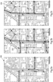
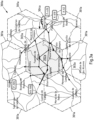
- Fig. 3a , b show schematic diagrams of exemplary coverage maps 300a, 300b of a communication network for illustrating this approach for different extents of electronic horizons.
- cells 301a sufficient network connectivity is provided, while in cell 302a, no coverage is provided.
- the geographical extent of the electronic horizon can be calculated in dependence of the vehicle's location 304a within the area of data coverage. For example, when a vehicle is expected to drive across the area 302a with no network coverage, the geographical extent of the electronic horizon can be increased so as to not end in this area 302a. Rather the road link(s) 303a included in the electronic horizon end in the adjacent areas 301a, where network coverage will be available again.
- the electronic horizon bridges the area 302a and continues to provide respective ADAS functionality (e.g. speed limit information) even in this area 302a.
- ADAS functionality e.g. speed limit information
- the number or extent of the road links 303b and thus the extent of the electronic horizon can be reduced to optimize the electronic horizon data payload size.
- Fig. 3a , b show a regular hexagon depiction for simplicity, coverage areas can take different, irregular shapes and irregular sizes, of course.
- the cloud service 120 receives the electronic horizon build request (action 132) directly from the vehicle 110
- the request may also come from other entities in alternative embodiments.
- a vehicle OEM may receive its vehicle fleet's requests and forwards them to the SLO-Server 121 in the cloud 120.
- This setup may allow for shifting the anonymization requirements to the OEM, i.e. the SLO-Server 121 could reply to the requests with communication session IDs with an unknown relation to a specific vehicle.
- the SLO-Server again uses the n recent position estimates to create an electronic horizon, containing the attributes discussed in the previous section.
- the electronic horizon is then provided to the vehicle (e.g. directly or alternatively via the OEM).
- Protocol Buffers may be used for the above described client server communication and for encoding of an electronic horizon data structure to optimize on data volume.
- the electronic horizon data structure may contain a list of road segments or paths, where each segment or path has a list of attributes e.g. with attribute type, value and/or offset range along the segment or path that the attribute applies to, and optionally a list of intersections each containing a list of side paths (making this a recursive data structure) with their headings or turn angles.
- the electronic horizon data contains the full road geometry information (e.g. latitude and longitude of shape points along the road, or possibly a spline, clothoid or other curve based representation), as this approach requires a significant data transfer volume for the geometry data, as well as a complex map matching algorithm consuming processing power.
- this approach requires a significant data transfer volume for the geometry data, as well as a complex map matching algorithm consuming processing power.
- one or more of the following approaches may be employed:
- FIG. 4 showing a block diagram with relevant components of a mobile device 400, such as vehicle 110 described above.
- block diagram of Fig. 4 may also be representative of other mobile device such as a smartphone, a tablet computer, a notebook computer, a navigation system or the like.
- Mobile device 400 comprises a processor 401.
- Processor 401 may represent a single processor or two or more processors, which are for instance at least partially coupled, for instance via a bus.
- Processor 401 executes a program code stored in program memory 402 (for instance program code causing mobile device 400 to perform one or more of the embodiments of a method according to the present disclosure or parts thereof, when executed on processor 401), and interfaces with a main memory 403.
- Program memory 402 may also contain an operating system for processor 401. Some or all of memories 402 and 403 may also be included into processor 401.
- One of or both of a main memory and a program memory of a processor could be fixedly connected to the processor (e.g. processor 401) or at least partially removable from the processor, for instance in the form of a memory card or stick.
- a program memory may for instance be a non-volatile memory. It may for instance be a FLASH memory (or a part thereof), any of a ROM, PROM, EPROM, MRAM or a FeRAM (or a part thereof) or a hard disc (or a part thereof), to name but a few examples.
- a program memory may for instance comprise a first memory section that is fixedly installed, and a second memory section that is removable from, for instance in the form of a removable SD memory card.
- a main memory (e.g. main memory 403) may for instance be a volatile memory. It may for instance be a DRAM memory, to give non-limiting example. It may for instance be used as a working memory for processor 401 when executing an operating system and/or programs.
- Any of the memories 402, 403 may be used for (at least temporarily) storing electronic horizon data, as described above.
- Radio interface 404 configured to receive and/or output data and/or information.
- radio interface 404 may be configured to receive radio signals from a radio node.
- the radio interface 404 is configured to receive radio signals that are transmitted by radio nodes of e.g. a WiFi (WLAN) network and/or any other radio communications system.
- radio interface 404 may comprise a WLAN radio interface including at least a WLAN receiver (RX).
- the WLAN receiver may also be a part of a WLAN transceiver. The WLAN receiver may aid in determining a position of the mobile device.
- processor 401 controls a communication interface 405 which is for example configured to communicate according to a cellular communication system like a 2G/3G/4G/5G or future generation cellular communication system.
- Mobile device 400 may use communication interface 405 to communicate with a server, e.g. with SLO-Server 121 depicted in Fig. 1 . Accordingly, the mobile device 400 may obtain an electronic horizon over communication interface 405, as described above.
- processor 401 may control a GNSS positioning sensor 406 (e.g. a GPS sensor or any other GNSS positioning techniques).
- GNSS positioning sensor may be configured to receive satellite signals of a GNSS system (e.g. GPS satellite signals) and to determine a position of the mobile device 400 at least partially based on satellite signals of the GNSS system that are receivable at this position.
- processor 401 may control further optional means and in particular sensors for performing ADAS functions.
- mobile device may in particular comprise one or more of a camera 407 (which may provide data to fusion component 113 or which may obtain information from the SLO-Client 111 for supporting the working of the camera 407), a motion sensor 408, such as an accelerometer or a gyroscope, and/or an odometer 409, which may be used in determining a position of the mobile device.
- a camera 407 which may provide data to fusion component 113 or which may obtain information from the SLO-Client 111 for supporting the working of the camera 407
- a motion sensor 408 such as an accelerometer or a gyroscope
- an odometer 409 which may be used in determining a position of the mobile device.
- the components 402 to 409 of mobile device 400 may for instance be connected with processor 401 by means of one or more serial and/or parallel busses.
- mobile device 400 may comprise various other component, such as a user interface (e.g. a touch-sensitive display, a keyboard, a touchpad, a display, etc.) to name but one example.
- a user interface e.g. a touch-sensitive display, a keyboard, a touchpad, a display, etc.
- FIG. 5 there is shown a block diagram of an exemplary embodiment of a server 500, such as SLO-Server 121 of Fig. 1 .
- server 500 may be used for the online construction of electronic horizons in order to provide respective electronic horizons to the vehicles, as described in detail above.
- Server 500 comprises a processor 501.
- Processor 501 may represent a single processor or two or more processors, which are for instance at least partially coupled, for instance via a bus.
- Processor 501 executes a program code stored in program memory 502 (for instance program code causing server 500 to perform one or more of the embodiments of a method according to the present disclosure or parts thereof, and interfaces with a main memory 503.
- Program memory 502 may also comprise an operating system for processor 501. Some or all of memories 502 and 503 may also be included into processor 501. Any memory may be used for storing map data and for storing constructed electronic horizons. As illustrated in Fig. 1 , server 500 may also comprise a map database or have access to a map database server, for obtaining respective map data.
- processor 501 controls a communication interface 504 which is for example configured to communicate according to a cellular communication system like a 2G/3G/4G/5G or future generation cellular communication system.
- Communication interface 504 of server 500 may be provided for communicate between mobile device 400 and server 500 (e.g. vehicle 110 and SLO-Server 120 of Fig. 1 ).
- Server 500 may further comprise a user interface 505 (e.g. a touch-sensitive display, a keyboard, a touchpad, a display, etc.).
- a user interface 505 e.g. a touch-sensitive display, a keyboard, a touchpad, a display, etc.
- server 500 may comprise various other components.
- Fig. 6 is a schematic illustration of examples of tangible and non-transitory computer-readable storage media according to the present invention that may for instance be used to implement memory 402 of Fig. 4 or memory 502 of Fig. 5 .
- Fig. 6 displays a flash memory 600, which may for instance be soldered or bonded to a printed circuit board, a solid-state drive 601 comprising a plurality of memory chips (e.g. Flash memory chips), a magnetic hard drive 602, a Secure Digital (SD) card 603, a Universal Serial Bus (USB) memory stick 604, an optical storage medium 605 (such as for instance a CD-ROM or DVD) and a magnetic storage medium 606.
- SD Secure Digital
- USB Universal Serial Bus
- connection in the described embodiments is to be understood in a way that the involved components are operationally coupled.
- connections can be direct or indirect with any number or combination of intervening elements, and there may be merely a functional relationship between the components.
- circuitry refers to any of the following:
- circuitry' also covers an implementation of merely a processor (or multiple processors) or section of a processor and its (or their) accompanying software and/or firmware.
- the term 'circuitry' also covers, for example, a baseband integrated circuit or applications processor integrated circuit for a mobile phone.
- Any processor may comprise but is not limited to one or more microprocessors, one or more processor(s) with accompanying digital signal processor(s), one or more processor(s) without accompanying digital signal processor(s), one or more special-purpose computer chips, one or more field-programmable gate arrays (FPGAS), one or more controllers, one or more application-specific integrated circuits (ASICS), or one or more computer(s).
- FPGAS field-programmable gate arrays
- ASICS application-specific integrated circuits
- the relevant structure/hardware has been programmed in such a way to carry out the described function.
- any of the actions or steps described or illustrated herein may be implemented using executable instructions in a general-purpose or special-purpose processor and stored on a computer-readable storage medium (e.g., disk, memory, or the like) to be executed by such a processor.
- a computer-readable storage medium e.g., disk, memory, or the like
- References to 'computer-readable storage medium' should be understood to encompass specialized circuits such as FPGAs, ASICs, signal processing devices, and other devices.
- any of the actions described or illustrated herein may be implemented using executable instructions in a general-purpose or special-purpose processor and stored on a computer-readable storage medium (e.g., disk, memory, or the like) to be executed by such a processor.
- a computer-readable storage medium e.g., disk, memory, or the like
- References to 'computer-readable storage medium' should be understood to encompass specialized circuits such as FPGAs, ASICs, signal processing devices, and other devices.
- A, or B, or C, or a combination thereof or "at least one of A, B and C” may be understood to be not exhaustive and to include at least the following: (i) A, or (ii) B, or (iii) C, or (iv) A and B, or (v) A and C, or (vi) B and C, or (vii) A and B and C.
Landscapes
- Engineering & Computer Science (AREA)
- Radar, Positioning & Navigation (AREA)
- Remote Sensing (AREA)
- Automation & Control Theory (AREA)
- Physics & Mathematics (AREA)
- General Physics & Mathematics (AREA)
- Health & Medical Sciences (AREA)
- General Health & Medical Sciences (AREA)
- Social Psychology (AREA)
- Traffic Control Systems (AREA)
- Telephonic Communication Services (AREA)
- User Interface Of Digital Computer (AREA)
Claims (20)
- Une méthode exécutée par un dispositif mobile (110, 400) ou une partie de celui-ci, la méthode comprenant:- fournir une indication d'une trajectoire du dispositif mobile (100, 400) à un serveur distant (121, 500) ;- obtenir (136), à partir du serveur distant (121, 500), un horizon électronique comprenant des données d'horizon électronique, sur la base de l'indication de la trajectoire ;- exécuter une ou plusieurs fonctions ADAS au moins partiellement basé sur l'horizon électronique obtenu ;caractérisée en ce que la méthode comprend en outre- déterminer une étendue souhaitée de l'horizon électronique au moins en partie basé sur une disponibilité attendue d'une connectivité réseau entre le dispositif mobile (110, 400) et le serveur distant (121, 500), et- fournir une demande pour l'horizon électronique, où l'étendue souhaitée de l'horizon électronique demandé est indiquée dans la demande ;- où l'horizon électronique obtenu est en outre basé sur la demande.
- Méthode selon la revendication 1, où l'horizon électronique est obtenu par une obtention répétée d'un horizon électronique de remplacement comprenant des données d'horizon électronique de remplacement.
- Méthode selon la revendication 1 ou 2, où l'horizon électronique ne comprend que des données d'horizon électronique nécessaires et/ou utiles spécifiquement pour une ou plusieurs fonctions ADAS.
- Méthode selon l'une des revendications 1 à 3, où les données électroniques d'horizon comprennent des informations de géométrie de route réduites.
- Méthode selon l'une des revendications 1 à 4, où la méthode comprend en outre :- construire, sur la base de l'horizon électronique obtenu, un horizon électronique interne pour distribuer les données d'horizon électronique obtenues avec l'horizon électronique à l'intérieur du dispositif mobile (110, 400).
- Méthode selon l'une des revendications 1 à 5, où la méthode comprend en outre- obtenir des données de capteur à partir d'un ou plusieurs capteurs du dispositif mobile, où l'exécution d'au moins une des fonctions ADAS est en outre au moins partiellement basée sur les données de capteur obtenues.
- Méthode selon l'une des revendications 1 à 6, où la ou les fonctions ADAS comprennent une ou plusieurs des fonctions suivantes :- une fonction intelligente d'assistance à la vitesse ;- une fonction d'avertissement de danger ;- une fonction d'indication de véhicule d'urgence ; et/ou- une fonction de détection des panneaux de signalisation.
- Méthode selon l'une des revendications 1 à 7, où une ou plusieurs des informations suivantes sont comprises dans les données électroniques relatives à l'horizon ou peuvent être dérivées de celles-ci :- un code de pays ;- un type de route ;- un cap de la route ;- une partie de la conduite ;- une distance jusqu'à la prochaine intersection.- un certain nombre de voies dans le sens de la conduite ;- un certain nombre de voies opposées à la direction de la conduite ; et/ou- l'indication d'une zone urbaine.
- Méthode selon l'une des revendications 1 à 8, où la méthode comprend en outre un ou plusieurs des éléments suivants :- vérifier (131) si l'horizon électronique doit être mis à jour ou remplacé ;- identifier (139) une position du dispositif mobile (110, 400) par rapport à l'horizon électronique.
- Méthode selon l'une des revendications 1 à 9, où l'indication de la trajectoire comprend une ou plusieurs estimations de la position, des informations sur le cap et/ou des informations sur la vitesse du dispositif mobile (110, 400) et/ou où l'indication de la trajectoire est fournie en réponse à la détermination de la nécessité de mettre à jour l'horizon électronique.
- Méthode selon l'une des revendications 1 à 10, où la méthode comprend en outre :- déterminer que l'horizon électronique doit être mis à jour ou remplacé si l'étendue restante de l'horizon électronique est inférieure ou égale à une étendue minimale ;- obtenir un horizon électronique mis à jour ou de remplacement avec l'étendue souhaitée.
- Méthode selon la revendication 9, où, pour identifier une position du dispositif mobile (110, 400) par rapport à l'horizon électronique, la méthode comprend en outre un ou plusieurs des suivants :- déterminer une distance parcourue par le dispositif mobile (110, 400) à partir d'une position pour laquelle une indication de trajectoire du dispositif mobile (110, 400) a été fournie au serveur (121, 500) ; et/ou- détecter les informations de cap ou de changement de cap du dispositif mobile (110, 400).
- Une méthode exécutée par un serveur (121, 500) ou une partie de celui-ci, comprenant- obtenir, à partir d'un dispositif mobile distant (110, 400), une indication d'une trajectoire du dispositif mobile (110, 400),- construire (135) un horizon électronique à partir de données cartographiques spécifiquement destinées à permettre au dispositif mobile (110, 400) de fournir une ou plusieurs fonctions ADAS, où l'horizon électronique comprend des données d'horizon électronique pour la ou les fonctions ADAS du dispositif mobile (110, 400), où les données d'horizon électronique couvrent une ou plusieurs trajectoires potentielles (204, 205, 303a, 303b) (110, 400) prédites d'être utilisées par le dispositif mobile sur la base de l'indication de la trajectoire ; et- fournir (136), au dispositif mobile (110, 400), l'horizon électronique caractérisé par la méthode comprenant en outre :- déterminer une étendue de l'horizon électronique au moins en partie sur la base de une disponibilité attendue d'une connectivité réseau entre le dispositif mobile (110, 400) et le serveur (121), où la construction de l'horizon électronique est au moins en partie basée sur l'étendue déterminée.
- Méthode de la revendication 13, où l'indication de la trajectoire comprend une ou plusieurs estimations de position du dispositif mobile (110, 400).
- La méthode de la revendication 13 ou 14, où la méthode comprend en outre un ou plusieurs des suivants :- obtenir (133) les données cartographiques à partir d'une base de données cartographiques (122) ; et/ou- identifier (134) une position du dispositif mobile (110, 400) par rapport aux données cartographiques.
- un dispositif mobile (110, 400) ou partie de celui-ci comprenant des moyens pour exécuter la méthode selon l'une des revendications 1 à 12.
- Un serveur (121, 500) ou partie de celui-ci comprenant des moyens pour exécuter la méthode selon l'une des revendications 13 à 15.
- Système (110, 120) comprenant un dispositif mobile ou une partie de celui-ci et un serveur ou une partie de celui-ci exécutant ensemble une méthode comprenant:- fournir, par le dispositif mobile (110, 400), au serveur (121, 500), une indication d'une trajectoire du dispositif mobile (110, 400) ;- obtenir, par le serveur (121, 500), du dispositif mobile (110, 400), l'indication d'une trajectoire du dispositif mobile (110, 400),- construire (135), par le serveur, un horizon électronique à partir de données cartographiques spécifiquement destinées à permettre au dispositif mobile (110, 400) de fournir une ou plusieurs fonctions ADAS, où l'horizon électronique comprend des données d'horizon électronique pour la ou les fonctions ADAS du dispositif mobile (110, 400), où les données d'horizon électronique couvrent une ou plusieurs trajectoires potentielles (204, 205, 303a, 303b) prédites d'être utilisées par le dispositif mobile (110, 400) sur la base de l'indication de la trajectoire ;- fournir (136), par le serveur (121, 500), au dispositif mobile (110, 400), l'horizon électronique ;- obtenir (136), par le dispositif mobile (110, 400), à partir du serveur (121, 500), l'horizon électronique ; et- exécuter, par le dispositif mobile (110, 400), au moins une des fonctions ADAS, au moins partiellement basée sur l'horizon électronique
caractérisé en ce que :- l'étendue de l'horizon électronique est déterminée par le serveur (121, 500) au moins en partie sur la base de la disponibilité attendue d'une connectivité réseau entre le dispositif mobile (110, 400) et le serveur (121, 500), et/ou- l'étendue de l'horizon électronique est déterminée par le dispositif mobile (110, 400) au moins en partie sur la base de la disponibilité attendue d'une connectivité réseau entre le dispositif mobile (110, 400) et le serveur distant (121, 500). - Produit de programme d'ordinateur, le produit de programme d'ordinateur, lorsqu'il est exécuté par un processeur d'un appareil, entraînant l'appareil à exécuter une méthode selon l'une des revendications 1 à 15.
- Support de stockage lisible par ordinateur comprenant le produit de programme informatique selon la revendication 19.
Priority Applications (5)
| Application Number | Priority Date | Filing Date | Title |
|---|---|---|---|
| ES21184886T ES3024372T3 (en) | 2021-07-09 | 2021-07-09 | Electronic horizon for adas function |
| EP21184886.6A EP4116676B1 (fr) | 2021-07-09 | 2021-07-09 | Horizon électronique pour fonction adas |
| PCT/EP2022/068944 WO2023280993A1 (fr) | 2021-07-09 | 2022-07-07 | Horizon électronique pour fonction de système avancé d'aide à la conduite (adas) |
| US18/575,759 US12601605B2 (en) | 2021-07-09 | 2022-07-07 | Electronic horizon for ADAS function |
| EP22741260.8A EP4367478A1 (fr) | 2021-07-09 | 2022-07-07 | Horizon électronique pour fonction de système avancé d'aide à la conduite (adas) |
Applications Claiming Priority (1)
| Application Number | Priority Date | Filing Date | Title |
|---|---|---|---|
| EP21184886.6A EP4116676B1 (fr) | 2021-07-09 | 2021-07-09 | Horizon électronique pour fonction adas |
Publications (3)
| Publication Number | Publication Date |
|---|---|
| EP4116676A1 EP4116676A1 (fr) | 2023-01-11 |
| EP4116676B1 true EP4116676B1 (fr) | 2025-04-09 |
| EP4116676C0 EP4116676C0 (fr) | 2025-04-09 |
Family
ID=76859560
Family Applications (2)
| Application Number | Title | Priority Date | Filing Date |
|---|---|---|---|
| EP21184886.6A Active EP4116676B1 (fr) | 2021-07-09 | 2021-07-09 | Horizon électronique pour fonction adas |
| EP22741260.8A Pending EP4367478A1 (fr) | 2021-07-09 | 2022-07-07 | Horizon électronique pour fonction de système avancé d'aide à la conduite (adas) |
Family Applications After (1)
| Application Number | Title | Priority Date | Filing Date |
|---|---|---|---|
| EP22741260.8A Pending EP4367478A1 (fr) | 2021-07-09 | 2022-07-07 | Horizon électronique pour fonction de système avancé d'aide à la conduite (adas) |
Country Status (4)
| Country | Link |
|---|---|
| US (1) | US12601605B2 (fr) |
| EP (2) | EP4116676B1 (fr) |
| ES (1) | ES3024372T3 (fr) |
| WO (1) | WO2023280993A1 (fr) |
Families Citing this family (2)
| Publication number | Priority date | Publication date | Assignee | Title |
|---|---|---|---|---|
| DE102023202623B3 (de) | 2023-03-23 | 2024-08-01 | Volkswagen Aktiengesellschaft | Verfahren zur Verwendung von Navigationsdaten in einem Fahrerassistenzsystem |
| DE102024100210A1 (de) * | 2024-01-04 | 2025-07-10 | Valeo Schalter Und Sensoren Gmbh | Bestimmen eines Umfangs von einem Fahrzeug bereitzustellenden Umgebungsinformationen nach der Art eines elektronischen Horizonts |
Family Cites Families (6)
| Publication number | Priority date | Publication date | Assignee | Title |
|---|---|---|---|---|
| US8965685B1 (en) | 2006-04-07 | 2015-02-24 | Here Global B.V. | Method and system for enabling precautionary actions in a vehicle |
| WO2009101163A2 (fr) * | 2008-02-15 | 2009-08-20 | Continental Teves Ag & Co. Ohg | Système embarqué de navigation et/ou d'aide à la conduite de véhicules |
| US9377313B2 (en) * | 2009-06-16 | 2016-06-28 | Tomtom North America Inc. | Methods and systems for creating digital street network database |
| US9747506B2 (en) | 2015-10-21 | 2017-08-29 | Ford Global Technologies, Llc | Perception-based speed limit estimation and learning |
| US11486716B2 (en) * | 2018-11-01 | 2022-11-01 | Lg Electronics Inc. | Vehicular electronic device, operation method of vehicular electronic device, and system |
| WO2021045256A1 (fr) * | 2019-09-04 | 2021-03-11 | 엘지전자 주식회사 | Appareil de fourniture d'itinéraire et son procédé de fourniture d'itinéraire |
-
2021
- 2021-07-09 EP EP21184886.6A patent/EP4116676B1/fr active Active
- 2021-07-09 ES ES21184886T patent/ES3024372T3/es active Active
-
2022
- 2022-07-07 WO PCT/EP2022/068944 patent/WO2023280993A1/fr not_active Ceased
- 2022-07-07 US US18/575,759 patent/US12601605B2/en active Active
- 2022-07-07 EP EP22741260.8A patent/EP4367478A1/fr active Pending
Also Published As
| Publication number | Publication date |
|---|---|
| US20240318972A1 (en) | 2024-09-26 |
| ES3024372T3 (en) | 2025-06-04 |
| WO2023280993A1 (fr) | 2023-01-12 |
| US12601605B2 (en) | 2026-04-14 |
| EP4116676A1 (fr) | 2023-01-11 |
| EP4116676C0 (fr) | 2025-04-09 |
| EP4367478A1 (fr) | 2024-05-15 |
Similar Documents
| Publication | Publication Date | Title |
|---|---|---|
| US10488868B2 (en) | Dynamic feature availability mapping for a vehicle | |
| US10902720B2 (en) | Traffic light signal adjustment notification improvement | |
| US10739147B2 (en) | Hierarchical route generation, provision, and selection | |
| CN110164122B (zh) | 用于路口的车辆列队系统控制 | |
| EP3244165B1 (fr) | Boucle de rétroaction basée sur une carte pour demander des observations supplémentaires à un véhicule | |
| EP3222973B1 (fr) | Mises à jour de carte provenant d'une flotte de véhicules reliés | |
| US10553110B2 (en) | Detection and estimation of variable speed signs | |
| EP3578924A2 (fr) | Polygones d'avertissement pour la météo à partir de données de capteur de véhicule | |
| CN114080537B (zh) | 收集与可导航网络有关的用户贡献数据 | |
| US20110047338A1 (en) | Self-learning map on basis on environment sensors | |
| WO2022193995A1 (fr) | Procédé de mise à jour de carte ainsi que procédé et appareil de prise de décision de conduite basée sur une carte | |
| WO2017145650A1 (fr) | Dispositif embarqué et système d'avertissement d'anomalie routière | |
| CN108242169A (zh) | 用于机动车的驾驶员辅助 | |
| US20200250864A1 (en) | Hazard warning polygons constrained based on end-use device | |
| JP2016033500A (ja) | 出発地・目的地抽出装置、出発地・目的地抽出方法 | |
| US12601605B2 (en) | Electronic horizon for ADAS function | |
| CN116206476A (zh) | 用于操作设计域边界的估计的方法和系统 | |
| JP2018190035A (ja) | 画像送信プログラム、及び、画像送信装置 | |
| CN111516684B (zh) | 驾驶支持装置 | |
| JP2020046194A (ja) | 地図データ更新システム、地図データ更新方法、及び地図データ更新プログラム | |
| US12205047B2 (en) | Method, apparatus, and computer program product for anonymized parking likelihood estimation | |
| CN114764411A (zh) | 地图更新系统 | |
| US20240194056A1 (en) | System and method for determining road work zone start location | |
| US20240191999A1 (en) | System and method for generating navigation instructions | |
| EP3742124A1 (fr) | Procédé, appareil et produit programme informatique pour un guidage d'itinéraire en fonction de la circulation |
Legal Events
| Date | Code | Title | Description |
|---|---|---|---|
| PUAI | Public reference made under article 153(3) epc to a published international application that has entered the european phase |
Free format text: ORIGINAL CODE: 0009012 |
|
| STAA | Information on the status of an ep patent application or granted ep patent |
Free format text: STATUS: THE APPLICATION HAS BEEN PUBLISHED |
|
| AK | Designated contracting states |
Kind code of ref document: A1 Designated state(s): AL AT BE BG CH CY CZ DE DK EE ES FI FR GB GR HR HU IE IS IT LI LT LU LV MC MK MT NL NO PL PT RO RS SE SI SK SM TR |
|
| STAA | Information on the status of an ep patent application or granted ep patent |
Free format text: STATUS: REQUEST FOR EXAMINATION WAS MADE |
|
| 17P | Request for examination filed |
Effective date: 20230705 |
|
| RBV | Designated contracting states (corrected) |
Designated state(s): AL AT BE BG CH CY CZ DE DK EE ES FI FR GB GR HR HU IE IS IT LI LT LU LV MC MK MT NL NO PL PT RO RS SE SI SK SM TR |
|
| STAA | Information on the status of an ep patent application or granted ep patent |
Free format text: STATUS: EXAMINATION IS IN PROGRESS |
|
| 17Q | First examination report despatched |
Effective date: 20240102 |
|
| GRAP | Despatch of communication of intention to grant a patent |
Free format text: ORIGINAL CODE: EPIDOSNIGR1 |
|
| STAA | Information on the status of an ep patent application or granted ep patent |
Free format text: STATUS: GRANT OF PATENT IS INTENDED |
|
| INTG | Intention to grant announced |
Effective date: 20241105 |
|
| GRAS | Grant fee paid |
Free format text: ORIGINAL CODE: EPIDOSNIGR3 |
|
| GRAA | (expected) grant |
Free format text: ORIGINAL CODE: 0009210 |
|
| STAA | Information on the status of an ep patent application or granted ep patent |
Free format text: STATUS: THE PATENT HAS BEEN GRANTED |
|
| AK | Designated contracting states |
Kind code of ref document: B1 Designated state(s): AL AT BE BG CH CY CZ DE DK EE ES FI FR GB GR HR HU IE IS IT LI LT LU LV MC MK MT NL NO PL PT RO RS SE SI SK SM TR |
|
| REG | Reference to a national code |
Ref country code: GB Ref legal event code: FG4D |
|
| REG | Reference to a national code |
Ref country code: CH Ref legal event code: EP |
|
| REG | Reference to a national code |
Ref country code: DE Ref legal event code: R096 Ref document number: 602021028794 Country of ref document: DE |
|
| REG | Reference to a national code |
Ref country code: IE Ref legal event code: FG4D |
|
| REG | Reference to a national code |
Ref country code: ES Ref legal event code: FG2A Ref document number: 3024372 Country of ref document: ES Kind code of ref document: T3 Effective date: 20250604 |
|
| U01 | Request for unitary effect filed |
Effective date: 20250505 |
|
| U07 | Unitary effect registered |
Designated state(s): AT BE BG DE DK EE FI FR IT LT LU LV MT NL PT RO SE SI Effective date: 20250509 |
|
| PGFP | Annual fee paid to national office [announced via postgrant information from national office to epo] |
Ref country code: GB Payment date: 20250529 Year of fee payment: 5 |
|
| PGFP | Annual fee paid to national office [announced via postgrant information from national office to epo] |
Ref country code: ES Payment date: 20250804 Year of fee payment: 5 |
|
| PG25 | Lapsed in a contracting state [announced via postgrant information from national office to epo] |
Ref country code: GR Free format text: LAPSE BECAUSE OF FAILURE TO SUBMIT A TRANSLATION OF THE DESCRIPTION OR TO PAY THE FEE WITHIN THE PRESCRIBED TIME-LIMIT Effective date: 20250710 Ref country code: NO Free format text: LAPSE BECAUSE OF FAILURE TO SUBMIT A TRANSLATION OF THE DESCRIPTION OR TO PAY THE FEE WITHIN THE PRESCRIBED TIME-LIMIT Effective date: 20250709 |
|
| PG25 | Lapsed in a contracting state [announced via postgrant information from national office to epo] |
Ref country code: PL Free format text: LAPSE BECAUSE OF FAILURE TO SUBMIT A TRANSLATION OF THE DESCRIPTION OR TO PAY THE FEE WITHIN THE PRESCRIBED TIME-LIMIT Effective date: 20250409 |
|
| PG25 | Lapsed in a contracting state [announced via postgrant information from national office to epo] |
Ref country code: HR Free format text: LAPSE BECAUSE OF FAILURE TO SUBMIT A TRANSLATION OF THE DESCRIPTION OR TO PAY THE FEE WITHIN THE PRESCRIBED TIME-LIMIT Effective date: 20250409 |
|
| PG25 | Lapsed in a contracting state [announced via postgrant information from national office to epo] |
Ref country code: RS Free format text: LAPSE BECAUSE OF FAILURE TO SUBMIT A TRANSLATION OF THE DESCRIPTION OR TO PAY THE FEE WITHIN THE PRESCRIBED TIME-LIMIT Effective date: 20250709 |
|
| PG25 | Lapsed in a contracting state [announced via postgrant information from national office to epo] |
Ref country code: IS Free format text: LAPSE BECAUSE OF FAILURE TO SUBMIT A TRANSLATION OF THE DESCRIPTION OR TO PAY THE FEE WITHIN THE PRESCRIBED TIME-LIMIT Effective date: 20250809 |
|
| U21 | Renewal fee for the european patent with unitary effect paid with additional fee |
Year of fee payment: 5 Effective date: 20251023 |
|
| PG25 | Lapsed in a contracting state [announced via postgrant information from national office to epo] |
Ref country code: SM Free format text: LAPSE BECAUSE OF FAILURE TO SUBMIT A TRANSLATION OF THE DESCRIPTION OR TO PAY THE FEE WITHIN THE PRESCRIBED TIME-LIMIT Effective date: 20250409 |
|
| PG25 | Lapsed in a contracting state [announced via postgrant information from national office to epo] |
Ref country code: CZ Free format text: LAPSE BECAUSE OF FAILURE TO SUBMIT A TRANSLATION OF THE DESCRIPTION OR TO PAY THE FEE WITHIN THE PRESCRIBED TIME-LIMIT Effective date: 20250409 |
|
| PG25 | Lapsed in a contracting state [announced via postgrant information from national office to epo] |
Ref country code: SK Free format text: LAPSE BECAUSE OF FAILURE TO SUBMIT A TRANSLATION OF THE DESCRIPTION OR TO PAY THE FEE WITHIN THE PRESCRIBED TIME-LIMIT Effective date: 20250409 |
|
| PLBE | No opposition filed within time limit |
Free format text: ORIGINAL CODE: 0009261 |
|
| STAA | Information on the status of an ep patent application or granted ep patent |
Free format text: STATUS: NO OPPOSITION FILED WITHIN TIME LIMIT |
|
| REG | Reference to a national code |
Ref country code: CH Ref legal event code: L10 Free format text: ST27 STATUS EVENT CODE: U-0-0-L10-L00 (AS PROVIDED BY THE NATIONAL OFFICE) Effective date: 20260218 |
|
| REG | Reference to a national code |
Ref country code: CH Ref legal event code: H13 Free format text: ST27 STATUS EVENT CODE: U-0-0-H10-H13 (AS PROVIDED BY THE NATIONAL OFFICE) Effective date: 20260224 |
|
| 26N | No opposition filed |
Effective date: 20260112 |