EP4131208A1 - Dispositif d'arbitrage d'itinéraire, dispositif de commande d'entraînement automatisé et système d'arbitrage d'itinéraire et d'entraînement automatisé - Google Patents
Dispositif d'arbitrage d'itinéraire, dispositif de commande d'entraînement automatisé et système d'arbitrage d'itinéraire et d'entraînement automatisé Download PDFInfo
- Publication number
- EP4131208A1 EP4131208A1 EP20926826.7A EP20926826A EP4131208A1 EP 4131208 A1 EP4131208 A1 EP 4131208A1 EP 20926826 A EP20926826 A EP 20926826A EP 4131208 A1 EP4131208 A1 EP 4131208A1
- Authority
- EP
- European Patent Office
- Prior art keywords
- vehicle
- travel
- priority
- route
- area
- Prior art date
- Legal status (The legal status is an assumption and is not a legal conclusion. Google has not performed a legal analysis and makes no representation as to the accuracy of the status listed.)
- Withdrawn
Links
Images


Classifications
-
- G—PHYSICS
- G01—MEASURING; TESTING
- G01C—MEASURING DISTANCES, LEVELS OR BEARINGS; SURVEYING; NAVIGATION; GYROSCOPIC INSTRUMENTS; PHOTOGRAMMETRY OR VIDEOGRAMMETRY
- G01C21/00—Navigation; Navigational instruments not provided for in groups G01C1/00 - G01C19/00
- G01C21/26—Navigation; Navigational instruments not provided for in groups G01C1/00 - G01C19/00 specially adapted for navigation in a road network
- G01C21/34—Route searching; Route guidance
- G01C21/3453—Special cost functions, i.e. other than distance or default speed limit of road segments
- G01C21/3461—Preferred or disfavoured areas, e.g. dangerous zones, toll or emission zones, intersections, manoeuvre types or segments such as motorways, toll roads or ferries
-
- B—PERFORMING OPERATIONS; TRANSPORTING
- B60—VEHICLES IN GENERAL
- B60W—CONJOINT CONTROL OF VEHICLE SUB-UNITS OF DIFFERENT TYPE OR DIFFERENT FUNCTION; CONTROL SYSTEMS SPECIALLY ADAPTED FOR HYBRID VEHICLES; ROAD VEHICLE DRIVE CONTROL SYSTEMS FOR PURPOSES NOT RELATED TO THE CONTROL OF A PARTICULAR SUB-UNIT
- B60W60/00—Drive control systems specially adapted for autonomous road vehicles
- B60W60/001—Planning or execution of driving tasks
-
- G—PHYSICS
- G08—SIGNALLING
- G08G—TRAFFIC CONTROL SYSTEMS
- G08G1/00—Traffic control systems for road vehicles
- G08G1/09—Arrangements for giving variable traffic instructions
- G08G1/0962—Arrangements for giving variable traffic instructions having an indicator mounted inside the vehicle, e.g. giving voice messages
- G08G1/0965—Arrangements for giving variable traffic instructions having an indicator mounted inside the vehicle, e.g. giving voice messages responding to signals from another vehicle, e.g. emergency vehicle
-
- G—PHYSICS
- G08—SIGNALLING
- G08G—TRAFFIC CONTROL SYSTEMS
- G08G1/00—Traffic control systems for road vehicles
- G08G1/09—Arrangements for giving variable traffic instructions
- G08G1/0962—Arrangements for giving variable traffic instructions having an indicator mounted inside the vehicle, e.g. giving voice messages
- G08G1/0967—Systems involving transmission of highway information, e.g. weather, speed limits
- G08G1/096708—Systems involving transmission of highway information, e.g. weather, speed limits where the received information might be used to generate an automatic action on the vehicle control
- G08G1/096716—Systems involving transmission of highway information, e.g. weather, speed limits where the received information might be used to generate an automatic action on the vehicle control where the received information does not generate an automatic action on the vehicle control
-
- G—PHYSICS
- G08—SIGNALLING
- G08G—TRAFFIC CONTROL SYSTEMS
- G08G1/00—Traffic control systems for road vehicles
- G08G1/09—Arrangements for giving variable traffic instructions
- G08G1/0962—Arrangements for giving variable traffic instructions having an indicator mounted inside the vehicle, e.g. giving voice messages
- G08G1/0967—Systems involving transmission of highway information, e.g. weather, speed limits
- G08G1/096708—Systems involving transmission of highway information, e.g. weather, speed limits where the received information might be used to generate an automatic action on the vehicle control
- G08G1/096725—Systems involving transmission of highway information, e.g. weather, speed limits where the received information might be used to generate an automatic action on the vehicle control where the received information generates an automatic action on the vehicle control
-
- G—PHYSICS
- G08—SIGNALLING
- G08G—TRAFFIC CONTROL SYSTEMS
- G08G1/00—Traffic control systems for road vehicles
- G08G1/16—Anti-collision systems
- G08G1/161—Decentralised systems, e.g. inter-vehicle communication
- G08G1/162—Decentralised systems, e.g. inter-vehicle communication event-triggered
-
- G—PHYSICS
- G08—SIGNALLING
- G08G—TRAFFIC CONTROL SYSTEMS
- G08G1/00—Traffic control systems for road vehicles
- G08G1/16—Anti-collision systems
- G08G1/164—Centralised systems, e.g. external to vehicles
-
- G—PHYSICS
- G08—SIGNALLING
- G08G—TRAFFIC CONTROL SYSTEMS
- G08G1/00—Traffic control systems for road vehicles
- G08G1/16—Anti-collision systems
- G08G1/166—Anti-collision systems for active traffic, e.g. moving vehicles, pedestrians, bikes
-
- G—PHYSICS
- G08—SIGNALLING
- G08G—TRAFFIC CONTROL SYSTEMS
- G08G1/00—Traffic control systems for road vehicles
- G08G1/16—Anti-collision systems
- G08G1/167—Driving aids for lane monitoring, lane changing, e.g. blind spot detection
-
- G—PHYSICS
- G08—SIGNALLING
- G08G—TRAFFIC CONTROL SYSTEMS
- G08G1/00—Traffic control systems for road vehicles
- G08G1/09—Arrangements for giving variable traffic instructions
- G08G1/0962—Arrangements for giving variable traffic instructions having an indicator mounted inside the vehicle, e.g. giving voice messages
- G08G1/0968—Systems involving transmission of navigation instructions to the vehicle
- G08G1/096833—Systems involving transmission of navigation instructions to the vehicle where different aspects are considered when computing the route
- G08G1/096844—Systems involving transmission of navigation instructions to the vehicle where different aspects are considered when computing the route where the complete route is dynamically recomputed based on new data
-
- G—PHYSICS
- G08—SIGNALLING
- G08G—TRAFFIC CONTROL SYSTEMS
- G08G1/00—Traffic control systems for road vehicles
- G08G1/09—Arrangements for giving variable traffic instructions
- G08G1/0962—Arrangements for giving variable traffic instructions having an indicator mounted inside the vehicle, e.g. giving voice messages
- G08G1/0968—Systems involving transmission of navigation instructions to the vehicle
- G08G1/096855—Systems involving transmission of navigation instructions to the vehicle where the output is provided in a suitable form to the driver
- G08G1/096861—Systems involving transmission of navigation instructions to the vehicle where the output is provided in a suitable form to the driver where the immediate route instructions are output to the driver, e.g. arrow signs for next turn
Definitions
- the present disclosure is related with a route arbitration apparatus, an automatic driving controller, and an automatic driving and route arbitration system.
- Patent document 1 WO 2016/147623
- patent document 1 is configured in such a way that a vehicle which carries out a lane change transmits a lane change request to a vehicle traveling in a lane which is a lane change destination.
- the technology of patent document 1 is such that a vehicle which receives a lane change request only evaluates the safety of its own traveling and permits a lane change, and does not evaluate safety in a broader perspective by considering behavior of a third party vehicle.
- patent document 1 is such that when, for example, a first vehicle traveling in a first traveling lane and a third vehicle traveling in a third traveling lane simultaneously plan a lane change to a second traveling lane, and a transmit a request to change lane to the second traveling lane to a second vehicle traveling in the second traveling lane, there is a possibility that the second vehicle, when able to travel safely itself, will permit the first vehicle and the third vehicle to change lane. Therefore, there is a possibility that the first vehicle and the second vehicle, which have simultaneously changed lane to the second traveling lane, will come into proximity, and a sudden evasive operation will be necessary.
- the necessity to carry out a lane change differs depending on a vehicle, such as a vehicle that carries out a merging or a diverging, a vehicle that avoids an obstacle, or an emergency vehicle. Therefore, there is a need to allow a vehicle with a high necessity to change lane to change lane with priority.
- the purpose of the present disclosure is to provide a route arbitration apparatus, an automatic driving controller, and an automatic driving and route arbitration system which can avoid an overlapping between travel routes and make vehicles carry out a traveling operation smoothly while considering priority between vehicles, in a broad perspective, about a multiple of vehicles existing in a periphery.
- a route arbitration apparatus including:
- An automatic driving controller including:
- An automatic driving and route arbitration system including:
- an overlapping of travel routes can be predicted in advance, based on a received multiple of vehicle target travel routes. Then, the priority between vehicles is determined, and the priority travel area which is an area where the highest priority vehicle can travel in accordance with the target travel route of the highest priority vehicle is determined and transmitted to the highest priority vehicle with the highest priority.
- the highest priority vehicle can be made to travel in accordance with the target travel route of the highest priority vehicle within the priority travel area preferentially.
- the avoidance travel area which is an area where the low priority can travel while avoiding the priority travel area is determined and transmitted to the priority vehicle. The low priority vehicle can be made to travel within the avoidance travel area, and an avoidance travel for avoiding contact with the highest priority vehicle can be performed.
- each vehicle can be made to carry out a smooth traveling operation.
- a travel route is not transmitted to each vehicle but the travel area where each vehicle can travel is transmitted, while making each vehicle consider a peripheral traveling state that each vehicle recognized, each vehicle can travel safely and appropriately within the travel area with flexibility.
- the automatic driving controller of the present disclosure since a travel route is not transmitted to each vehicle from the route arbitration apparatus but the travel area where each vehicle can travel is transmitted, while making each vehicle consider a peripheral traveling state that each vehicle recognized, each vehicle can travel safely and appropriately within the travel area with flexibility.
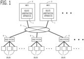
- Fig. 1 is a figure showing a schematic overall configuration of the automatic driving and route arbitration system.
- the route arbitration apparatus 1 is provided in a server 2 connected to a network 3. That is, a function of the route arbitration apparatus 1 is realized by the server 2 executing an application (a program) of the route arbitration apparatus 1.
- a multiple of route arbitration apparatus 1 is provided, and shares and arbitrates traveling routes of a multiple of vehicles.
- the server 2 is a MEC (Multi-access Edge Computing) server, for example. The details of MEC are described in literature (ETSI GS MEC 003 V2.1.1 (2019-01)), for example.
- the network 3 is a core network, for example.
- the route arbitration apparatus 1 and the server 2 may be disposed close to an area to control.
- Each vehicle 20 is connected to a near base station 4 via wireless communication.
- a multiple of base stations 4 are distributed and provided at each point so as to cover a road network.
- the base station 4 is a wireless station that performs wireless communication with a mobile terminal instrument mounted in a vehicle existing within a communication area, using a cellular wireless communications standard such as 4G or 5G, and is connected to the network 3. Therefore, each vehicle 20 and the route arbitration apparatus 1 are communicatively connected via the base station 4 and the network 3.
- FIG. 2 shows a schematic configuration diagram of the route arbitration apparatus 1.
- the route arbitration apparatus 1 is provided with a communication unit 40, a target route receiving unit 41, a route overlapping determining unit 42, a priority determining unit 43, a travel area determining unit 44, a travel area transmitting unit 45, an avoidance reason transmitting unit 46, a transfer information receiving unit 47, a determination delay unit 48, and the like.
- the communication unit 40 communicates with a multiple of vehicles.
- the communication unit 40 is connected to the network 3, and communicates with an arbitration object vehicle via the network 3 and the base station 4.
- the arbitration object vehicle is, for example, a vehicle positioned in a region being controlled by the route arbitration apparatus 1.
- the target route receiving unit 41 receives a target travel route from each vehicle.
- the target travel route is time series data, such as a vehicle position (latitude, longitude, and altitude), a vehicle speed, and a vehicle orientation of each time.
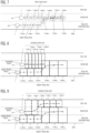
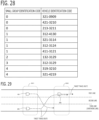
- Fig. 3 shows an example of the time series data of the target travel route.
- the time series data is formed of a time, a latitude, a longitude, a vehicle speed, and a vehicle orientation (for example, an azimuth of the forward and backward direction of the vehicle).
- the target travel route data includes basic information of vehicle, such as such as a vehicle category, a vehicle outline form, vehicle information, and a degree of urgency of the vehicle.
- the vehicle category is an ambulance, a police car, a route bus, a cargo vehicle, a taxi, a general passenger car, and a two-wheel motorbike, and the like, for example.
- the vehicle information is a vehicle performance, a vehicle state, a number of occupants, and the like, for example.
- the transfer information receiving unit 47 receives transfer permission information indicating that a travel route may be transferred to other vehicle, from each vehicle.
- the determination delay unit 48 makes the determination of the route overlapping determining unit 42 described later delay, until the target travel routes are received from respective vehicles. According to this configuration, the determination of the route overlapping determining unit 42 can be performed in a state where the target travel routes of respective vehicles were received, and a determination accuracy of the route overlapping determining unit 42 can be improved.
- the determination delay unit 48 may manage the reception of the target travel routes for each a multiple of vehicles which are close with each other. When the target travel routes of respective vehicles are not received despite a preliminarily set waiting time elapsing, the determination delay unit 45 may make the determination of the route overlapping determining unit 42 start.
- the waiting time for each vehicle as described above, may be set to a waiting time transmitted from each vehicle together with the target travel route.
- the avoidance reason transmitting unit 46 transmits an avoidance reason that the avoidance travel area is determined, to the low priority vehicle in which the avoidance travel area is determined by the travel area determining unit 44 described below.
- a vehicle which receives the avoidance reason informs the avoidance reason to the occupant using the speaker 24b or the display 24c, as described later.
- the avoidance reason is, for example, "carrying out a lane change in order to give way to an emergency vehicle", "carrying out a lane change in order to give way to a vehicle on the right", “reducing speed in order to give way to a vehicle on the right", or "changing a travel route considering a peripheral traveling state". According to this configuration, the occupant of the low priority vehicle can be aware of the own vehicle traveling state, and convenience of the occupant can be improved.
- the target travel routes between vehicles When a mutual overlapping of the target travel routes between vehicles occurs, it is necessary to arbitrate so that the target travel routes between vehicles do not overlap mutually in order to prevent contact of vehicles. Especially, when a multiple of vehicles carry out a lane change at the same timing, since it is relatively difficult to predict the lane change of other vehicle beforehand, the target travel routes between vehicles may overlap mutually. In particular, the difficulty of predicting increases when two or more vehicles carry out a lane change simultaneously.
- FIG. 4 An overlapping of travel routes accompanied with the lane change will be described using the example of Fig. 4 .
- target travel routes received from a first vehicle 100 and a second vehicle 200 are visualized by being superimposed on a road form.
- the first vehicle 100 is starting a lane change 300 ms after a current time T (T + 300 ms)
- the second vehicle 200 is starting a lane change 300 ms after the current time T (T + 300 ms) .
- a position of the first vehicle 100 and a position of the second vehicle 200 overlap with each other 500 ms (T + 500 ms) and 600 ms (T + 600 ms) after the current time T.
- the route overlapping determining unit 42 determines whether or not target travel routes of respective vehicles overlap with each other.
- the priority determining unit 43 determines priority between vehicles.
- the travel area determining unit 44 determines a priority travel area which is an area where the highest priority vehicle which is a vehicle with the highest priority among the overlapping vehicles whose target traveling routes were determined to overlap mutually can travel in accordance with the target traveling route of the highest priority vehicle.
- the travel area determining unit 44 determines an avoidance travel area which is an area where a low priority vehicle which is a vehicle other than the highest priority vehicle among the overlapping vehicles can travel while avoiding the priority travel area.
- the travel area determining unit 44 transmits the priority travel area to the highest priority vehicle via the communication unit 40 and makes the highest priority vehicle travel within the priority travel area, and transmits the avoidance travel area to the low priority vehicle and makes the low priority vehicle travel within the avoidance travel area.
- an overlapping of travel routes can be predicted in advance, based on a received multiple of vehicle target travel routes. Then, the priority between vehicles is determined, and the priority travel area which is an area where the highest priority vehicle can travel in accordance with the target travel route of the highest priority vehicle is determined and transmitted to the highest priority vehicle with the highest priority.
- the highest priority vehicle can be made to travel in accordance with the target travel route of the highest priority vehicle within the priority travel area preferentially.
- the avoidance travel area which is an area where the low priority vehicle can travel while avoiding the priority travel area is determined and transmitted to the low priority vehicle.
- the low priority vehicle can be made to travel within the avoidance travel area, and an avoidance travel for avoiding contact with the highest priority vehicle can be performed. Therefore, an overlapping of travel routes is avoided in advance, and each vehicle can be made to carry out a smooth traveling operation.
- the route overlapping determining unit 42 determines whether or not the received target travel routes of respective vehicles overlap with each other. For example, the route overlapping determining unit 42 determines whether or not the target travel routes of respective vehicles overlap with each other accompanied with a lane change.
- the lane change includes a changing a traveling lane on a road having a multiple of traveling lanes, a changing a traveling lane accompanied with moving from a current traveling road to another road (for example, a merging or a detachment at a point at which roads merge or diverge, or a left or right turn), and the like.
- the route overlapping determining unit 42 determines a vehicle which carry out a lane change, based on the target travel route of each vehicle. For example, the route overlapping determining unit 42 compares the target travel route of each vehicle and high accuracy map data, and identifies a vehicle whose lane is changing, or identifies a vehicle that will carry out a lane change from a change in orientation of the vehicle. Then, the route overlapping determining unit 42 determines whether or not the position of a vehicle that will carry out a lane change is closer than a determination distance to the position of each other vehicle at each time. When there are two or more vehicles that will carry out a lane change, the route overlapping determining unit 42 carries out the same determination for each vehicle that will carry out a lane change.
- the route overlapping determining unit 42 determines whether or not the target travel routes of respective vehicles overlaps mutually due to a difference of each vehicle speed in the same lane and the like although not accompanied with a lane change.
- the route overlapping determining unit 42 determines inter-vehicle proximity by also considering the outline form of each vehicle and the orientation of each vehicle. A determination distance in the left and right direction from a vehicle is set to be shorter than a determination distance in the forward and backward direction from a vehicle so that two vehicles traveling side by side are not determined to be in proximity. The route overlapping determining unit 42 determines whether or not an inter-vehicle outline is closer than the left and right direction determination distance in the left or right direction from each vehicle, and determines whether or not the inter-vehicle outline is closer than the forward and backward direction determination distance in the forward or backward direction from each vehicle.
- the priority determining unit 43 determines priority between vehicles.
- the priority between vehicles can also be expressed as an order of priority between vehicles.
- the priority determining unit 43 may determine priority between vehicles that were determined to be overlapped with each other, or may determine priority among vehicles that were determined to be overlapped with each other and vehicles in a periphery of the overlapping vehicles . In the latter case, a case where the travel routes of the vehicles in a periphery of the overlapping vehicles is affected by a change in the travel route of an overlapping vehicle can also be accommodated.
- the priority determining unit 43 determines the priority between vehicles by combining a multiple of rules. For example, evaluation points are set for each rule, and higher evaluation points are set for a rule with higher priority. The priority determining unit 43 determines whether or not each rule is satisfied for each vehicle, totals up the evaluation points of the satisfied rules, and sets the total value as the evaluation points of the respective vehicle. Then, the priority determining unit 43 determines that a vehicle with higher evaluation points is a vehicle with higher priority. When there are a multiple of vehicles with the same evaluation points, the priority determining unit 43 prioritizes a vehicle selected at random.
- the following kinds of rules are included in the multiple of rules.
- the following rules are examples, and other arbitrary rules and evaluation points can be used.
- a rule of rule 1 and a rule of rule 2 may be replaced.
- Information necessary for determining whether each rule is satisfied can also be obtained from each vehicle, high accuracy map data, and the like.
- Rule 7 whether a vehicle is a vehicle whose speed is higher than other vehicle that is an object of priority determination.
- a set speed of an ACC adaptive cruise control
- Evaluation points 4 4.
- the priority determining unit 43 at least determines priority between vehicles by combining a multiple of rules relating to the necessity of a lane change.
- rule 1, rule 3, rule 4, rule 10, and the like correspond to rules relating to the necessity of a lane change.
- the priority determining unit 43 makes the priority of a vehicle from which transfer permission information was received lower than the priority of a vehicle from which transfer permission information was not received. For example, when there are a multiple of vehicles with the same evaluation points, the priority determining unit 43 makes the priority of a vehicle from which transfer permission information was received lower. Also, the priority determining unit 43 may reduce the evaluation points of a vehicle from which transfer permission information was received.
- the travel area determining unit 44 determines a priority travel area which is an area where the highest priority vehicle which is a vehicle with the highest priority among the overlapping vehicles whose target traveling routes were determined to overlap mutually can travel in accordance with the target traveling route of the highest priority vehicle. And, the travel area determining unit 44 determines an avoidance travel area which is an area where a low priority vehicle which is a vehicle other than the highest priority vehicle among the overlapping vehicles can travel while avoiding the priority travel area.
- the priority travel area where the highest priority vehicle can travel in accordance with the target travel route of the highest priority vehicle can be expressed as "an area where the highest priority vehicle can travel on the basis of the target travel route of the highest priority vehicle", "an area where the highest priority vehicle can travel including the target travel route of the highest priority vehicle", or the like.
- the travel area determining unit 44 determines an area at each time point where the highest priority vehicle can travel in accordance with the target traveling route of the highest priority vehicle at future each time point, as the priority travel area.
- the travel area determining unit 44 determines an area at each time point where the low priority vehicle can travel while avoiding the priority travel area at each time point, as the avoidance travel area. That is to say, the travel area determining unit 44 determines time series areas, as the priority travel area and the avoidance travel area.
- each travel area is set so as not to overlap with each other at each time point, the same area can be set to each travel area by shifting time. Accordingly, the travel area can be set more intricately. Then, each vehicle can travel within the travel area at each time point with flexibility.
- the travel area determining unit 44 determines, as the priority travel area, an area which includes a multiple of traveling lanes including a traveling lane where the highest priority vehicle can travel and which does not become the disturbance of traveling of peripheral vehicle. And, the travel area determining unit 44 determines, as the avoidance travel area, an area which includes a multiple of traveling lanes including a traveling lane where the low priority vehicle can travel and which does not become the disturbance of traveling of peripheral vehicle.
- the highest priority vehicle can travel safely and appropriately with flexibility within the multiple of traveling lanes determined in the priority travel area. Since an area including a multiple of traveling lanes is determined as the avoidance travel area if it is settable, the low priority vehicle can travel safely and appropriately with flexibility within the multiple of traveling lanes determined in the avoidance travel area. Since these multiple of traveling lanes include traveling lanes which does not become the disturbance of traveling of peripheral vehicle, traveling of the peripheral vehicle is not restricted more than necessary.
- the travel area determining unit 44 When determining the priority travel area of the highest priority vehicle, the travel area determining unit 44 considers a peripheral traveling state of the highest priority vehicle. When determining the avoidance travel area of the low priority vehicle, the travel area determining unit 44 considers a peripheral traveling state of the low priority vehicle. According to this configuration, appropriate and safe the priority travel route and the avoidance travel route where the peripheral traveling state was considered can be determined.
- the peripheral traveling state includes a traveling state of the peripheral vehicle of the highest priority vehicle or the low priority vehicle, a state of the traveling road in the periphery of the highest priority vehicle or the low priority vehicle, and the like.
- the target travel route of the vehicle is used as the traveling state of the peripheral vehicle.
- a current traveling state of the vehicle for example, the speed and the vehicle orientation
- a road form, a lane, sign information, and the like, obtained from high accuracy map data is used as the state of the peripheral traveling road.
- the road monitoring system is a system that monitors a road state, a traffic light state, a traveling vehicle state, and the like, based on various kinds of information.
- the travel area determining unit 44 determines an area where the highest priority vehicle can travel along a traveling lane which is a destination for the lane change and a current traveling lane, as the priority travel area.
- the travel area determining unit 44 determines an area where the second vehicle 200 can travel along the second lane of a lane change destination and the third lane of the current traveling lane, as the priority travel area.
- the travel area determining unit 44 sets a lane area which has an area setting width in the forward and backward direction and a lane width, centering on a position at each time point of the target travel route of the second vehicle 200, as the priority travel area at each time point.
- the travel area determining unit 44 expands the priority travel area at each time point in the lateral direction so that the current traveling lane is included. If a traveling of the peripheral vehicle is disturbed by expansion to the current traveling lane (for example, if the target travel route of the other vehicle whose target travel route does not overlap exists in this area expanded to the current traveling lane), expansion is not performed.
- the area setting width in the forward and backward direction is increased.
- the peripheral traveling state of the highest priority vehicle is considered at this determination of the priority travel area, since there is no traveling state of peripheral vehicle other than the low priority vehicle and no state of the peripheral traveling road which should be especially considered, setting is done as mentioned above.
- the highest priority vehicle can carry out the lane change preferentially and travel according to the initial target travel route, without possibility of contact to other vehicles. Even when it becomes impossible to carry out the lane change due to some factors, such as occurrence of an obstacle, since the current traveling lane is also included in the priority travel area, the highest priority vehicle can also travel the current traveling lane preferentially without possibility of contact to other vehicles. Accordingly, the highest priority vehicle can travel safely according to the initial target travel route, and the highest priority vehicle can travel safely and appropriately with flexibility within the priority travel area including the current traveling lane and the traveling lane of the lane change destination, while considering the peripheral traveling state that the highest priority vehicle recognized.
- the travel area determining unit 44 determines, as the avoidance travel area, an area where the low priority vehicle can carry out a lane change while avoiding the priority travel area of the highest priority vehicle by performing acceleration or deceleration.
- the travel area determining unit 44 determines an avoidance travel route of time series which makes the first vehicle 100 decelerate and carry out a lane change behind the priority travel area; and sets a lane area which has an area setting width in the forward and backward direction and the lane width, centering on a position at each time point of the avoidance travel route, as the avoidance travel area at each time point.
- the travel area determining unit 44 expands the avoidance travel area at each time point in the lateral direction so that the current traveling lane is included. If a traveling of the peripheral vehicle is disturbed by expansion to the current traveling lane (for example, if the target travel route of the other vehicle whose target travel route does not overlap exists in this area expanded to the current traveling lane), expansion is not performed.
- the peripheral traveling state of the low priority vehicle is considered at this determination of the avoidance travel area, since there is no traveling state of peripheral vehicle other than the highest priority vehicle and no state of the peripheral traveling road which should be especially considered, setting is done as mentioned above.
- the travel area determining unit 44 may determine an avoidance travel route which makes the low priority vehicle accelerate and carry out a lane change in front of the priority travel area.
- the low priority vehicle transfers route to the highest priority vehicle, and can carry out a lane change and travel while avoiding contact with the highest priority vehicle. Even when it becomes impossible to carry out the lane change due to some factors, such as occurrence of an obstacle, since the current traveling lane is also included in the avoidance travel area, the low priority vehicle can also travel the current traveling lane without possibility of contact to the highest priority vehicle. Accordingly, the low priority vehicle can avoid contact with the highest priority vehicle and carry out a lane change safely, and the low priority vehicle can travel safely and appropriately with flexibility within the avoidance travel area including the current traveling lane and the traveling lane of the lane change destination, while considering the peripheral traveling state that the low priority vehicle recognized.
- the travel area determining unit 44 determines an area where the low priority vehicle can travel along the current traveling lane while avoiding the priority travel area, as the avoidance travel area.
- the travel area determining unit 44 sets, as the avoidance travel area at each time point, a lane area which has an area setting width in the forward and backward direction and a lane width, centering on a position at each time point when traveling the current traveling lane with the vehicle speed at each time point of the target travel route of the first vehicle 100 which is the low priority vehicle or the current vehicle speed.
- the peripheral traveling state of the low priority vehicle is considered at this determination of the avoidance travel area, since there is no traveling state of peripheral vehicle other than the highest priority vehicle and no state of the peripheral traveling road which should be especially considered, setting is done as mentioned above.
- the avoidance travel area is set in this way, by traveling the current traveling lane, the low priority vehicle transfers route to the highest priority vehicle, and can carry out a lane change and travel while avoiding contact with the highest priority vehicle.
- the low priority vehicle can travel safely and appropriately within the avoidance travel area with flexibility such as performing deceleration or acceleration.
- FIG. 7 shows the received target travel routes of the first vehicle 100 and the second vehicle 200.
- FIG. 8 shows the priority travel area and the avoidance travel area after determination of the travel area determining unit 44.
- the target travel route of the second vehicle 200 is starting a lane change 300 ms after the current time T (T + 300 ms), and the target travel route of the first vehicle 100 is maintaining the current traveling lane.
- the position of the first vehicle 100 and the position of the second vehicle 200 overlap with each other from 400 ms (T + 400 ms) to 600 ms (T + 600 ms) after the current time T accompanied with the lane change by the second vehicle 200.
- the priority of the second vehicle 200 is higher than the priority of the first vehicle 100. Therefore, the second vehicle 200 is determined as the highest priority vehicle, and the first vehicle 100 is determined as the low priority vehicle.
- the travel area determining unit 44 determines an area where the low priority vehicle can travel while avoiding the priority travel area by performing deceleration or acceleration, as the avoidance travel area.
- the travel area determining unit 44 determines an avoidance travel route of time series which makes the first vehicle 100 decelerate and travel behind the priority travel area in the current traveling lane; and sets a lane area which has the area setting width in the forward and backward direction and the lane width, centering on a position at each time point of the avoidance travel route, as the avoidance travel area at each time point. In this case, the travel area determining unit 44 expands the avoidance travel area at each time point to the first lane in the lateral direction.
- expansion is not performed.
- expansion to the third lane is not performed since the third lane is a lane where the highest priority vehicle travels, it may be expanded after the highest priority vehicle passes forward.
- the low priority vehicle By decelerating and traveling the current traveling lane, the low priority vehicle transfers route to the highest priority vehicle, and can carry out a lane change and travel while avoiding contact with the highest priority vehicle. And, the low priority vehicle can travel safely and appropriately within the avoidance travel area while adjusting speed in accordance with characteristics of vehicle. It is also possible to perform a lane change to some factors.
- the travel area determining unit 44 determines an area where the low priority vehicle can travel while avoiding the priority travel area by carrying out a lane change, as the avoidance travel area.
- the travel area determining unit 44 determines an avoidance travel route of time series which makes the first vehicle 100 carry out a lane change and avoid the priority travel area; and sets a lane area which has the area setting width in the forward and backward direction and the lane width, centering on a position at each time point of the avoidance travel route, as the avoidance travel area at each time point.
- the travel area determining unit 44 considers, as the peripheral traveling state, that a lane exists on the left side which is a side opposite to the highest priority vehicle, and that other vehicle, an obstacle, and the like do not exist on its left side lane.
- the avoidance travel area which makes it decelerate or accelerate like the third case mentioned above is determined.
- the travel area determining unit 44 determines an area where the highest priority vehicle can travel along the current traveling lane, as the priority travel area.
- the highest priority vehicle when a lane change is not included in the target travel route of the highest priority vehicle, the highest priority vehicle can travel safely and appropriately within the priority travel area which is set along the current traveling lane, with flexibility such as performing deceleration or acceleration.
- FIG. 10 shows the received target travel routes of the first vehicle 100 and the second vehicle 200.
- FIG. 11 shows the priority travel area and the avoidance travel area after determination of the travel area determining unit 44.
- the target travel route of the first vehicle 100 is starting a lane change to the right side lane 300 ms after the current time T (T + 300 ms), and the target travel route of the second vehicle 200 is maintaining the current traveling lane.
- the position of the first vehicle 100 and the position of the second vehicle 200 overlap with each other in the vicinity of 400 ms after the current time T (T + 400 ms), accompanied with the lane change by the first vehicle 100.
- the priority of the second vehicle 200 is higher than the priority of the first vehicle 100. Therefore, the second vehicle 200 is determined as the highest priority vehicle, and the first vehicle 100 is determined as the low priority vehicle.
- the travel area determining unit 44 determines an area where the second vehicle 200 can travel along the second lane which is the current traveling lane, as the priority travel area. For example, the travel area determining unit 44 sets a lane area which has an area setting width in the forward and backward direction and a lane width centering on a position at each time point of the target travel route of the second vehicle 200, as the priority travel area at each time point. The travel area determining unit 44 expands the priority travel area at each time point to the third lane in the lateral direction.
- expansion is not performed. Expansion to the first lane is not performed since the first lane is a lane where the low priority vehicle travels.
- peripheral traveling state of the highest priority vehicle is considered at this determination of the priority travel area, since there is no traveling state of peripheral vehicle other than the low priority vehicle and no state of the peripheral traveling road which should be especially considered, setting is done as mentioned above.
- the travel area determining unit 44 determines, as the avoidance travel area, an area where the low priority vehicle can carry out a lane change while avoiding the priority travel area of the highest priority vehicle by performing deceleration.
- the travel area determining unit 44 may determine an area where the low priority vehicle can travel along the current traveling lane while avoiding the priority travel area, as the avoidance travel area.
- the travel area determining unit 44 determines an area where the low priority vehicle with the lower priority can travel while avoiding the priority travel area of the highest priority vehicle and while avoiding the avoidance travel area of the low priority vehicle with the higher priority, as the avoidance travel area of the multiple of low priority vehicles.
- FIG. 12 shows the received target travel routes of the first vehicle 100, the second vehicle 200, and the third vehicle 300.
- FIG. 13 shows the priority travel area and the avoidance travel area after determination of the travel area determining unit 44.
- the target travel route of the first vehicle 100 is starting a lane change to the right side lane 300 ms after the current time T (T + 300 ms)
- the target travel route of the second vehicle 200 is maintaining the current traveling lane
- the target travel route of the third vehicle 300 is starting a lane change to the left side lane 300 ms after the current time T (T + 300 ms) .
- the positions of the first vehicle 100, the second vehicle 200, and the third vehicle 300 overlap with each other 400 ms after the current time T (T + 400 ms) accompanied with the lane changes by the first vehicle 100 and the third vehicle 300.
- the evaluation points are higher than those of other coinciding vehicles, the second vehicle 200 is determined as the highest priority vehicle, and the first vehicle 100 and the third vehicle 300 are determined as the low priority vehicles. Then, since the first vehicle 100 is positioned farther forward than the third vehicle 300, rule 6 is satisfied, and 4 points are added to the evaluation points of the first vehicle 100. And, since the speed of the third vehicle 300 is higher than the speed of the first vehicle 100, rule 7 is satisfied, and 4 points are added to the evaluation points of the third vehicle 300. On the other hand, since the third vehicle 300 is traveling in the overtaking lane, rule 9 is satisfied, and 4 points are added to the evaluation points of the third vehicle 300. Therefore, since the third vehicle 300 has a total of 8 evaluation points, and the first vehicle 100 has a total of 4 evaluation points, the priority of the third vehicle 300 is higher than the priority of the first vehicle 100.
- the travel area determining unit 44 determines an area where the second vehicle 200 can travel along the second lane which is the current traveling lane, as the priority travel area. For example, the travel area determining unit 44 sets a lane area which has an area setting width in the forward and backward direction and a lane width, centering on a position at each time point of the target travel route of the second vehicle 200, as the priority travel area at each time point. The travel area determining unit 44 does not expand the priority travel area at each time point to the first lane and the third lane in the lateral direction. This is because the first vehicle 100 and the third vehicle 300 are traveling in the first lane and the third lane, and traveling of these peripheral vehicles are disturbed.
- the travel area determining unit 44 determines the avoidance travel route of the third vehicle 300 whose priority is higher than the first vehicle 100, among the low priority vehicles. Since the mutual overlapping of the target travel routes occurs accompanied with the lane change of the third vehicle 300, the travel area determining unit 44 determines, as the avoidance travel area, an area where the third vehicle 300 can carry out a lane change while avoiding the priority travel area by delaying timing of the lane change .
- the travel area determining unit 44 determines an avoidance travel route of time series which makes the third vehicle 300 delay timing of the lane change and carry out the lane change behind the priority travel area; and sets a lane area which has the area setting width in the forward and backward direction and the lane width centering on a position at each time point of the avoidance travel route, as the avoidance travel area at each time point.
- the travel area determining unit 44 expands the avoidance travel area at each time point in the lateral direction so that the current traveling lane is included. If a traveling of the peripheral vehicle is disturbed by expansion to the current traveling lane (for example, if the target travel route of the other vehicle whose target travel route does not overlap exists in this area expanded to the current traveling lane), expansion is not performed.
- the travel area determining unit 44 determines an area where the first vehicle 100 can carry out a lane change while avoiding the priority travel area of the second vehicle 200 and the avoidance travel area of the third vehicle 300 by performing deceleration. As shown in FIG.
- the travel area determining unit 44 determines an avoidance travel route of time series which makes the first vehicle 100 decelerate and carry out a lane change behind the priority travel area of the second vehicle 200 and the avoidance travel area of the third vehicle 300; and sets a lane area which has the area setting width in the forward and backward direction and the lane width, centering on a position at each time point of the avoidance travel route, as the avoidance travel area at each time point.
- the travel area determining unit 44 expands the avoidance travel area at each time point in the lateral direction so that the current traveling lane is included. If a traveling of the peripheral vehicle is disturbed by expansion to the current traveling lane (for example, if the target travel route of the other vehicle whose target travel route does not overlap exists in this area expanded to the current traveling lane), expansion is not performed.
- the route arbitration apparatus 1 is provided with an arithmetic processor 70 (computer) such as a CPU (Central Processing Unit), storage devices 71 such as a RAM (Random Access Memory), a ROM (Read Only Memory), and a hard disk (HDD), an communication device 72 which performs data communication, and the like.
- the communication device 72 is connected to the network 3, and carries out wired data communication.
- a program for each function, high accuracy map data, and the like are stored in the storage device 71, such as the hard disk, of the route arbitration apparatus 1.
- Each processing of the route arbitration apparatus 1 is realized by the arithmetic processing processor 70 executing a program (software) stored in the storage device 71, and collaborating with other hardware devices such as the storage device 71 and the communication device 72.
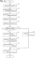
- Processing of the route arbitration apparatus 1 will be explained using the flowchart of FIG. 15 .
- Processing of the flowchart of FIG. 15 is executed repeatedly every constant calculation period, for example.
- the target route receiving unit 41 receives a target travel route from each vehicle via the communication unit 40.
- the transfer information receiving unit 47 receives transfer permission information from each vehicle.
- the determination delay unit 48 makes the determination of the route overlapping determining unit 42 delay, until the target travel routes are received from respective vehicles.
- the route overlapping determining unit 42 determines whether or not the received target travel routes of respective vehicles overlap with each other. When determining that it is overlapping, it advances to the step S06, and when determining that it is not overlapping, it advances to the step S05. In the step S05, the travel area determining unit 44 transmits a command to maintain the target travel route to each vehicle via the communication unit 40.
- the priority determining unit 43 determines priority between vehicles. Then, in the step S07, as mentioned above, the travel area determining unit 44 determines a priority travel area which is an area where the highest priority vehicle which is a vehicle with the highest priority among the overlapping vehicles whose target traveling routes were determined to overlap mutually can travel in accordance with the target traveling route of the highest priority vehicle. Then, the travel area transmitting unit 45 transmits the priority travel area to the highest priority vehicle via the communication unit 40, and makes the highest priority vehicle travel within the priority travel area.
- the travel area determining unit 44 determines an avoidance travel area which is an area where a low priority vehicle which is a vehicle other than the highest priority vehicle among the overlapping vehicles can travel while avoiding the priority travel area. Then, the travel area transmitting unit 45 transmits the avoidance travel area to the low priority vehicle via the communication unit 40, and makes the low priority vehicle travel within the avoidance travel area.
- the avoidance reason transmitting unit 46 transmits an avoidance reason that the avoidance travel area is determined, to the low priority vehicle in which the avoidance travel area is determined by the travel area determining unit 44.
- Fig. 16 shows a schematic configuration of a system mounted in each vehicle 20.
- Each vehicle 20 includes a vehicle-mounted network 21, a communication device 22, a locator 23, a navigation device 24, an automatic driving controller 25, a power controller 26, a brake controller 27, an automatic steering controller 28, a light controller 29, and the like.
- the vehicle-mounted network 21 is a network that carries out reciprocal communication among the vehicle-mounted devices 22 to 29.
- a communications standard such as a CAN (controller area network), Ethernet, or FlexRay (both registered trademarks) is used.
- the communication device 22 is a communication device that carries out wireless communication with the base station 4 existing within a communication area using an antenna 22a, and carries out a communication of data with the route arbitration apparatus 1. Also, the communication device 22 may communicate with a nearby vehicle.
- the locator 23 is a device that recognizes a position of the own vehicle, and has a GPS antenna, an acceleration sensor, a direction sensor, and the like.
- the locator 23 matches own vehicle positional information (latitude, longitude, altitude) obtained from the GPS antenna or the like, information obtained from a periphery monitoring device 25a, and the like, and high accuracy map data, thereby recognizing highly accurate own vehicle positional information.
- the navigation device 24 determines a target route from the current position to the target point, based on the current position of the own vehicle obtained from the locator 23, the target point, the map data, and the road state.
- the navigation device 24 includes a human interface 24a, and receives a setting of a target point by a vehicle occupant.
- the navigation device 24 can output navigation-related information to a speaker 24b and a display 24c, thereby providing the information to the vehicle occupant.
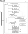
- the automatic driving controller 25 is a device that carries out recognition, evaluation, and control for automatic driving. As shown in FIG. 17 , the automatic driving controller 25 is provided with a sensor information acquisition unit 251, a recognition unit 252, a communication unit 253, a target travel route generation unit 254, a management unit 255, a target travel route changing unit 256, a vehicle control unit 257, and the like.
- the communication unit 253 communicates with other vehicle-mounted device via the vehicle-mounted network 21.
- the sensor information acquisition unit 251 acquires information from the periphery monitoring device 25a.
- the periphery monitoring device 25a is a camera, a radar, and the like, that monitors the periphery of the own vehicle.
- As the radar a millimeter wave radar, a laser radar, an ultrasonic radar, and the like are used.
- the recognition unit 252 recognizes a peripheral traveling state of the own vehicle.
- the recognition unit 252 recognizes a peripheral traveling state such as a traveling state of a peripheral vehicle and a state of a traveling road, based on the own vehicle positional information, the high accuracy map data, and the peripheral information obtained from the periphery monitoring device 25a.
- a traveling state of the peripheral vehicle a position, a speed, a traveling direction, a traveling lane, a size, a category, and the like of the peripheral vehicle are recognized.
- a road form, a lane, an existence or nonexistence of an obstacle, an existence or nonexistence of a pedestrian, road sign information, a road traffic rule such as a section in which a lane change is prohibited, signal information, traffic jam information, and the like are recognized.
- the target travel route generation unit 254 determines a target travel route where the own vehicle travels, considering the peripheral traveling state of the own vehicle.
- the target travel route generating unit 254 determines a short distance target travel route for traveling along the target route to the target point set by the navigation device 24 in accordance with the recognized peripheral travel state.
- the short distance target travel route is a target travel route from the current point to a point a predetermined distance forward or until a predetermined time ahead. How far in the future the target travel route is determined is arbitrary, but as an example, a target travel route within a range corresponding to a range that can be detected by the periphery monitoring device 25a is determined.
- the target travel route generating unit 254 determines the target travel route that contact with the other vehicle, the obstacle, the pedestrian, or the like is avoided. And, when a road form different from the high accuracy map data is recognized by the periphery monitoring device 25a, the target travel route generating unit 254 determines the target travel route that is in accordance with the recognized road form. And, when sign information or signal information is recognized by the periphery monitoring device 25a, the target travel route generating unit 254 determines the target travel route that is in accordance with the recognized sign information or signal information.
- the target travel route generating unit 254 determines the target travel route that is in accordance with the travel route of the navigation device 24.
- the target travel route is a travel plan of time series for a vehicle position, a vehicle traveling direction, a vehicle speed, a traveling lane, a position where a lane change is carried out, and the like, at each time in the future.
- the management unit 255 transmits a determined target travel route to the route arbitration apparatus 1 via the communication device 22.
- the management unit 255 transmits, as target travel route data, time series data such as the vehicle position (latitude, longitude, altitude), the vehicle speed, and the vehicle orientation at each time.
- time series data such as the vehicle position (latitude, longitude, altitude), the vehicle speed, and the vehicle orientation at each time.
- the example of the time series data of the target travel route is shown in FIG. 3 .
- the time series data is formed of a time, a latitude, a longitude, a vehicle speed, and a vehicle orientation (for example, an azimuth of the forward and backward direction of the vehicle).
- Basic information of vehicle is included in the target travel route data to be transmitted.
- a vehicle category for example, an ambulance, a police car, a route bus, a cargo vehicle, a taxi, a general passenger car, a two-wheeled motorbike), a vehicle outline form, vehicle information (for example, a vehicle performance, a vehicle state, a number of occupants), and information relating to a degree of urgency of the vehicle.
- the management unit 255 transmits transfer permission information to the route arbitration apparatus 1 together with target travel route data. Transfer permission is set by an occupant via the human interface 24a or the like, or set as default in the vehicle.
- the management unit 255 may transmit a waiting time that the determination delay unit 48 of the route arbitration apparatus 1 described later waits for a reception of a target travel route, to the route arbitration apparatus 1 together with target travel route data.
- the waiting time transmitted by the management unit 255 is set to a difference between a time farthest in the future at which the target travel route will be traveled and the current time.
- the route arbitration apparatus 1 determines whether or not the received target travel routes of respective vehicles overlap with each other; determines the priority travel area which is an area where the highest priority vehicle can travel in accordance with the target travel route, and the avoidance travel area which is an area where the low priority vehicle can travel while avoiding the priority travel area, considering the priority between vehicles determined to be overlapped; and transmits the priority travel area to the highest priority vehicle and transmits the avoidance travel area to the low priority vehicle.
- the management unit 255 receives the priority travel area transmitted from the route arbitration apparatus 1.
- the management unit 255 receives the avoidance travel area transmitted from the route arbitration apparatus 1.
- the management unit 255 When the management unit 255 receives an avoidance reason that the avoidance travel area is determined, from the route arbitration apparatus 1, the management unit 255 informs the avoidance reason to the occupant via the communication unit 253 and the navigation device 24 using one or both of the speaker 24b and the display 24c.
- the target travel route changing unit 256 changes the target travel route considering the peripheral traveling state of the own vehicle so that the target travel route of the own vehicle becomes within the priority travel area or the avoidance travel area.
- the target travel route changing unit 256 of the second vehicle 200 which is the highest priority vehicle determines a target travel route similar to the transmitted target travel route, as shown in FIG. 18 by a thick dashed dotted line.
- the target travel route changing unit 256 of the first vehicle 100 which is the low priority vehicle changes the target travel route so as to be within the avoidance travel area, considering the current peripheral traveling state of the own vehicle, as shown by a thick dotted line. Specifically, the target travel route changing unit 256 changes into a target travel route which decelerates the first vehicle 100 and carries out a lane change.
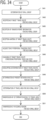
- FIG. 19 shows a different example.
- the recognition units 252 of the first vehicle 100 and the second vehicle 200 newly recognize a broken down vehicle 400 before and after receiving the priority travel area or the avoidance travel area. Accordingly, although the transmitted target travel route is within the received priority travel area as shown in FIG. 19 by a thin dashed dotted line, the target travel route changing unit 256 of the second vehicle 200 which is the highest priority vehicle changes into a target travel route which avoids the broken down vehicle 400 within the priority travel area, considering the newly recognized broken down vehicle 400, as shown in FIG. 19 by a thick dashed dotted line.
- the target travel route changing unit 256 changed into a target travel route which maintains the third lane which is the current traveling lane in order to avoid the broken down vehicle 400 which exists in the second lane.
- the target travel route changing unit 256 of the first vehicle 100 which is the low priority vehicle changes the target travel route so as to be within the avoidance travel area, considering the newly recognized broken down vehicle 400, as shown by a thick dotted line.
- the target travel route changing unit 256 changed into a target travel route which maintains the first lane which is the current traveling lane in order to avoid the broken down vehicle 400 which exists in the second lane.
- each vehicle can travel safely and appropriately within the travel area with flexibility, considering the peripheral traveling state that each vehicle recognized.
- the management unit 255 transmits the target travel route after change to the vehicle control unit 257.
- the management unit 255 transmits the target travel route generated by the target travel route generation unit 254 to the vehicle control unit 257.
- the vehicle control unit 257 makes the own vehicle travel along with the target travel route transmitted from the management unit 255.
- the vehicle control unit 257 determines a target speed, a target steering angle, an operation command of the direction indicator, and the like, in order to travel along the target travel route; commands the target speed to the power controller 26 and the brake controller27; commands the target steering angle to the automatic driving controller 28; and commands the operation command of the direction indicator to the light controller 29.
- the power controller 26 controls an output of the power machine 26a, such as an internal combustion engine or a motor, so that the speed of the own vehicle follows the target speed.
- the brake controller 27 controls a braking operation of the electric brake device 27a so that the speed of the own vehicle follows the target speed.
- the automatic steering controller 28 controls the electric steering device 28a so that the steering angle follows the target steering angle.
- the light controller 29 controls the direction indicator 29a in accordance with the operation command of the direction indicator.
- a configuration may differ from the configuration described in the present application.
- the automatic driving and route arbitration system of the present application can be configured.
- the automatic driving controller 25 is provided with an arithmetic processor 80 (computer) such as a CPU (Central Processing Unit), storage devices 81 such as a R_AM (Random Access Memory), a ROM (Read Only Memory), and a hard disk (HDD), an communication device 82 which performs data communication, and the like.
- the communication device 82 is connected to the vehicle-mounted network 21, the periphery monitoring device 25a, and the like, and carries out data communication.
- a program for each function and the like are stored in the storage device 81, such as the hard disk, of the automatic driving controller 25.
- Each processing of the automatic driving controller 25 is realized by the arithmetic processing processor 80 executing a program (software) stored in the storage device 81, and collaborating with other hardware devices such as the storage device 81 and the communication device 82.
- Processing of the automatic driving controller 25 will be explained using the flowchart of FIG. 21 .
- Processing of the flowchart of FIG. 21 is executed repeatedly every constant calculation period, for example.
- the communication unit 253 communicates with other vehicle-mounted device, such as the navigation device 24 or the locator 23, via the vehicle-mounted network 21, and acquires information such as the target route to the target point, the positional information of the own vehicle, and the high accuracy map data.
- the communication unit 253 communicates at an appropriate time and as necessary.
- the sensor information acquisition unit 251 acquires information from the periphery monitoring device 25a.
- the recognition unit 252 recognizes a peripheral traveling state such as a traveling state of a peripheral vehicle and a state of a traveling road, based on the own vehicle positional information, the high accuracy map data, and the peripheral information obtained from the periphery monitoring device 25a.
- the target travel route generating unit 254 determines a short distance target travel route for traveling along the target route to the target point set by the navigation device 24, in accordance with the recognized peripheral travel state.
- the management unit 255 transmits the target travel route determined by the target travel route generation unit 254, to the route arbitration apparatus 1 via the communication unit 253 and the communication device 22. And, when transfer permission is set, the management unit 255 transmits the transfer permission information to the route arbitration apparatus 1 together with the target travel route data.
- the management unit 255 After transmitting the target travel route, waits to receive the priority travel area or the avoidance travel area from the route arbitration apparatus 1 until a preset waiting time elapses, advances to the step S27 at the time of receiving when receiving, and advances to step S28 when not receiving despite the waiting time elapsing.
- the management unit 255 transmits the target travel route to the vehicle control unit 257, since the time for receiving from the route arbitration apparatus 1 has expired.
- the target travel route changing unit 256 changes the target travel route considering the peripheral traveling state of the own vehicle so that the target travel route of the own vehicle becomes within the priority travel area or the avoidance travel area.
- the management unit 255 transmits the target travel route after changing processing by the target travel route changing unit 256, to the vehicle control unit 257. And, in the step S30, when an avoidance reason that the avoidance travel area is determined is received from the route arbitration apparatus 1, the management unit 255 informs the avoidance reason to the occupant via the communication unit 253 and the navigation device 24 using one or both of the speaker 24b and the display 24c.
- the vehicle control unit 257 determines a target speed, a target steering angle, an operation command of the direction indicator, and the like, in order to travel along with the target travel route transmitted from the management unit 255; and commands the power controller 26, the brake controller 27, the automatic steering controller 28, and the light controller 29. Then, each controller carries out a control of the each device in accordance with a command value.
- Embodiment 2 Next, the automatic driving and route arbitration system according to Embodiment 2 will be explained. The explanation for constituent parts the same as those in Embodiment 1 will be omitted.
- the basic configuration of the automatic driving and route arbitration system according to the present embodiment is the same as that of Embodiment 1.
- Embodiment 2 is different from Embodiment 1 in that, after performing the route change to the received target travel route of each vehicle considering the peripheral traveling state, processing of the route overlapping determining unit 42, the priority determining unit 43, the travel area determining unit 44 and the like is performed.
- FIG. 22 shows the schematic configuration diagram of the route arbitration apparatus 1 according to the present embodiment.
- the route arbitration apparatus 1 is further provided with a traveling state considering unit 49 in addition to from the communication unit 40 to the determination delay unit 48.
- the traveling state considering unit 49 changes the received target travel route of each vehicle considering the peripheral traveling state.
- the route overlapping determining unit 42 and the priority determining unit 43 carry out a determination using the target travel route after changing processing performed by the traveling state considering unit 49.
- the travel area determining unit 44 determines the priority travel area and the avoidance travel area using the target travel route after changing processing performed by the traveling state considering unit 49, considering the peripheral traveling state. About a vehicle whose target travel route was not changed by the traveling state considering unit 49, the received target travel route is used in the processing of each unit.
- the target travel route of each vehicle is changed considering the peripheral traveling state grasped by the route arbitration apparatus 1. Then, the determination of travel area is performed using the target travel route after changing processing, and the determination result becomes a more appropriate result that is in accordance with the peripheral traveling state.
- a traveling state of a vehicle peripheral to each vehicle whose target travel route was received, a state of a peripheral traveling road, and the like are included in the peripheral traveling state.
- a current traveling state of vehicle for example, the speed and the vehicle orientation
- a road form, a lane, sign information, and the like obtained from high accuracy map data is used.
- an obstacle, a pedestrian, signal information, traffic jam information, and the like, obtained from a road monitoring system or each vehicle is used as the state of the peripheral traveling road.
- the traveling state considering unit 49 changes the target travel route so as to avoid the impediment.
- traffic information such as traffic jam information, sign information, or traffic light information in the target travel route as the peripheral traveling state
- the traveling state considering unit 49 changes the target travel route so as to perform a deceleration, a stopping, an acceleration, or the like, of the vehicle.
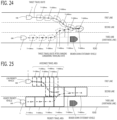
- FIG. 23 shows the received target travel routes of the first vehicle 100 and the second vehicle 200.
- FIG. 24 shows the target travel routes after changing processing of each vehicle considering the peripheral traveling state.
- FIG. 25 shows the priority travel area and the avoidance travel area after determination which used the target travel route after changing processing of each vehicle.
- the target travel route of the second vehicle 200 is a route that maintains the traveling lane. However, there is a broken down stationary vehicle that the second vehicle 200 has not yet recognized farther ahead in the traveling lane of the second vehicle 200.
- the route arbitration apparatus 1 recognized the broken down stationary vehicle from information obtained by a road monitoring system or a preceding vehicle.
- the target travel route of the first vehicle 100 is starting a lane change to the right side lane 300 ms after the current time T (T + 300 ms) .
- the route arbitration apparatus 1 did not recognize any peripheral traveling state to be paid particular attention, about the target travel route of the first vehicle 100.
- the traveling state considering unit 49 changed the target travel route of the second vehicle 200 so as to avoid the broken down stationary vehicle, considering the broken down stationary vehicle. That is, the traveling state considering unit 49 changed into a target travel route of the second vehicle 200 that starts a lane change to the left side lane 300 ms after the current time T (T + 300 ms), which is before the broken down stationary vehicle. On the other hand, the traveling state considering unit 49 did not change the target travel route of the first vehicle 100. As the result, the position of the first vehicle 100 and the position of the second vehicle 200 overlap with each other 400 ms after the current time T (T + 400 ms) accompanied with the lane changes by the first vehicle 100 and the second vehicle 200. Accordingly, the route overlapping determining unit 42 determines that the target travel route of the first vehicle 100 after changing processing and the target travel route of the second vehicle 200 overlap with each other.
- the priority determining unit 43 determines priority between the second vehicle 200 and the first vehicle 100 after changing processing performed by the traveling state considering unit 49. Since the second vehicle 200 avoids an obstacle ahead of the vehicle, rule 1 is satisfied, and 10 points are added to the evaluation points of the second vehicle 200. As the result, the priority of the second vehicle 200 is higher than the priority of the first vehicle 100. Therefore, the second vehicle 200 is determined as the highest priority vehicle, and the first vehicle 100 is determined as the low priority vehicle.
- the travel area determining unit 44 determines the priority travel area which is an area where the second vehicle 200 which is the highest priority vehicle can travel in accordance with the target travel route of the second vehicle 200 after changing processing, considering the peripheral traveling state.
- the travel area determining unit 44 determines the avoidance travel area which is an area where the first vehicle 100 which is the low priority vehicle can travel while avoiding the priority travel area, considering the peripheral traveling state.
- the travel area determining unit 44 sets a lane area which has an area setting width in the forward and backward direction and a lane width, centering on a position at each time point of the target travel route of the second vehicle 200 after changing processing, as the priority travel area at each time point. Since the broken down stationary vehicle exists in the current traveling lane unlike the case of FIG. 5 , the priority travel area is not expanded to the current traveling lane.
- the travel area determining unit 44 determines an avoidance travel route of time series which makes the first vehicle 100 decelerate and carry out a lane change behind the priority travel area; and sets a lane area which has the area setting width in the forward and backward direction and the lane width, centering on a position at each time point of the avoidance travel route, as the avoidance travel area at each time point.
- the travel area determining unit 44 expands the avoidance travel area at each time point in the lateral direction so that the current traveling lane is included.
- the second vehicle 200 changes into a target travel route that avoids the broken down stationary vehicle at the time point of recognizing the broken down stationary vehicle by the periphery monitoring device 25a, and the route arbitration apparatus 1 determines travel area of each vehicle according to it. Accordingly, no serious problem occurs. However, there is a possibility that traveling operation smoothness will worsen slightly due to the first vehicle 100 canceling a lane change, returning to the original lane, or the like, after starting the lane change.
- Processing of the route arbitration apparatus 1 according to the present embodiment will be explained using the flowchart of FIG. 26 .
- Processing of the flowchart of FIG. 26 is executed repeatedly every constant calculation period, for example.
- the target route receiving unit 41 receives a target travel route from each vehicle via the communication unit 40.
- the transfer information receiving unit 47 receives transfer permission information from each vehicle.
- the determination delay unit 48 makes the determination of the route overlapping determining unit 42 delay, until the target travel routes are received from respective vehicles.
- the traveling state considering unit 49 acquires a peripheral traveling state from a road monitoring system, each vehicle, and the like via the communication unit 40.
- the traveling state considering unit 49 changes the received target travel route of each vehicle, considering the peripheral traveling state.
- the route overlapping determining unit 42 determines whether or not the target travel routes of respective vehicles after changing processing performed by the traveling state considering unit 49 overlap with each other accompanied with a lane change. When determining that it is overlapping, it advances to the step S39, and when determining that it is not overlapping, it advances to the step S37.
- the route overlapping determining unit 42 performs the overlapping determination using the received target travel route, about a vehicle whose target travel route was not changed by the traveling state considering unit 49.
- the travel area determining unit 44 determines whether or not a vehicle whose target travel route was changed by the traveling state considering unit 49 exists. When determining that it exists, it advances to the step S38, and when determining that it does not exist, it ends processing.
- the travel area determining unit 44 determines a changed travel area which is an area where a changed vehicle whose target travel route was changed can travel in accordance with the changed target travel route of the changed vehicle, considering a peripheral traveling state. Then, the travel area transmitting unit 45 transmits the changed travel area to the vehicle whose target travel route was changed via the communication unit 40, and makes the changed vehicle whose target travel route was changed travel within the changed travel area.
- the priority determining unit 43 determines priority between vehicles based on the target travel routes of respective vehicles after changing processing performed by the traveling state considering unit 49.
- the priority determining unit 43 determines the priority of a vehicle whose target travel route was not changed by the traveling state considering unit 49, based on the received target travel route.
- the travel area determining unit 44 determines the priority travel area which is an area where the highest priority vehicle which is a vehicle with the highest priority among the overlapping vehicles whose target traveling routes after changing processing were determined to overlap mutually can travel in accordance with the target traveling route after changing processing of the highest priority vehicle, considering the peripheral traveling state. Then, the travel area transmitting unit 45 transmits the priority travel area to the highest priority vehicle via the communication unit 40, and makes the highest priority vehicle travel within the priority travel area.
- the travel area determining unit 44 determines an avoidance travel area which is an area where a low priority vehicle which is a vehicle other than the highest priority vehicle among the overlapping vehicles can travel while avoiding the priority travel area, considering the peripheral traveling state. Then, the travel area transmitting unit 45 transmits the avoidance travel area to the low priority vehicle via the communication unit 40, and makes the low priority vehicle travel within the avoidance travel area.
- the avoidance reason transmitting unit 46 transmits an avoidance reason that the avoidance travel area is determined, to the low priority vehicle in which the avoidance travel area is determined via communication unit 40.
- the change reason transmitting unit 46 transmits an avoidance reason such as "the travel route is changed considering the peripheral traveling state" to the highest priority vehicle.
- Embodiment 3 Next, the automatic driving and route arbitration system according to Embodiment 3 will be explained. The explanation for constituent parts the same as those in each of Embodiments 1 and 2 will be omitted.
- the basic configuration of the automatic driving and route arbitration system according to the present embodiment is the same as that of Embodiments 1 and 2.
- Embodiment 3 is different from Embodiments 1 and 2 in that a travel area is determined for each small group.
- FIG. 27 shows the schematic configuration diagram of the route arbitration apparatus 1 according to the present embodiment.
- the route arbitration apparatus 1 is further provided with a small group managing unit 50 in addition to the communication unit 40 to the traveling state considering unit 49.
- route arbitration apparatus 1 processes the travel routes of all arbitrated vehicles at one time, there is a problem that an amount of arithmetic processing carried out at one time increases. Also, when a vehicle with high latency is included, there is a possibility that this will adversely affect an overall travel route computation.
- the small group managing unit 50 determines a small group formed of one or more vehicles whose distances are close. And, the route overlapping determining unit 42 determines, for each small group, whether or not vehicle target travel routes overlap with each other, accompanied with a lane change .
- the priority determining unit 43 determines priority between vehicles for each small group.
- the travel area determining unit 44 for each small group, determines a travel area of each vehicle so that travel routes do not overlap with each other, considering the priority between vehicles.
- travel areas can be appropriately determined for each small group in which distances are close and travel routes affect each other.
- Vehicles outside the small group, whose distances are long and whose travel routes do not affect each other, can be excluded from the travel area determination, whereby the determination process can be facilitated. Accordingly, the amount of arithmetic processing carried out at one time can be reduced, and even if a vehicle with high latency is included in a certain small group, an adverse effect on computing the travel routes of other small group can be restricted.
- the small group managing unit 50 determines a small group formed of one or a multiple of vehicles whose distance, speed, and direction of travel are closer than a determination value, based on a position, a traveling speed, a direction of travel, and the like received from each vehicle. For example, the small group managing unit 50 determines one or more vehicles wherein an inter-vehicle distance is within a determination distance, an inter-vehicle difference in direction of travel is within a determination angle difference, and an inter-vehicle difference in speed is within a determination speed difference, as one small group. When the inter-vehicle distance is equal to or greater than the determination distance, the small group managing unit 50 sets a limit of the small group at that inter-vehicle distance. Vehicles traveling in the same direction in one or a multiple of lanes can be selected by determining the direction of travel and the speed.
- the small group managing unit 50 may determine a small group formed of one or more vehicles within a specific range on a road, based on positional information and the like received from each vehicle. For example, the small group managing unit 50 determines one or more vehicles existing on the same road link as one small group, based on road map data and positional information of each vehicle.
- the road link is a road section between nodes such as freeway ramps or intersections. A section such that the road link is divided into appropriate lengths may also be seen as a road link.
- a lane change may be dangerous, or a lane change may be prohibited by the traffic rule, in a vicinity of a freeway ramp or a vicinity of an intersection. Accordingly, a vehicle existing at this kind of road converging point may be excluded from a small group.
- one or more vehicles existing at this kind of road converging point may be determined to be one small group.
- a multiple of route arbitration apparatus 1 is provided, and shares and arbitrates traveling routes of a multiple of vehicles.
- One or more vehicles in the same small group are arbitrated by the same route arbitration apparatus 1.
- the small group managing unit 50 creates and updates a small group list whenever determining a small group.
- the small group list is, for example, a kind of list shown in Fig. 28 showing a correspondence relationship between a small group identification code and a vehicle identification code.
- the route overlapping determining unit 42 sets a small group for which a determination is performed as a determination object small group, and determines whether or not the travel routes of the respective vehicles in the determination object small group overlap with the travel routes of the respective vehicles in a small group in the periphery of (for example, ahead or behind) the determination object small group.
- the priority determining unit 43 determines priority between vehicles, considering the vehicles of the peripheral small group determined to be overlapped.
- the priority determining unit 43 determines priority between vehicles in the determination object small group.
- the travel area determining unit 44 determines the priority travel area and the avoidance travel area about the overlapping vehicles determined to be overlapped, considering the priority between vehicles.
- the travel area determining unit 44 determines the priority travel area and the avoidance travel area, considering the priority between vehicles, in the determination object small group. According to this configuration, travel areas can be determined so as not to overlap with the travel routes of a peripheral small group, even when determining travel routes for each small group.
- the first vehicle 100 and the second vehicle 200 are determined as a first small group 501, as the distances, speeds, and directions of travel are close, and the third vehicle 300 is determined as a second small group 502, as the distance between the first vehicle 100 or the second vehicle 200 and the third vehicle 300 is equal to or greater than a determination distance.
- the second vehicle 200 needs to reduce speed sharply after changing lane. Then, the route overlapping determining unit 42 determines that the travel route of the second vehicle 200 of the first small group 501 overlaps with the travel route of the third vehicle 300 of the second small group 502. As shown in FIG. 30 , the travel area determining unit 44 determines an avoidance travel area of the second vehicle 200 so as not to overlap with the travel route of the third vehicle 300.
- the second vehicle 200 when considering only the first small group 501, the second vehicle 200 has a higher priority than the first vehicle 100, but the priority determining unit 43 considers the third vehicle 300, lowers the priority of the second vehicle 200, and determines that the first vehicle 100 has a higher priority than the second vehicle 200. Then, the travel area determining unit 44 determines a priority travel area which is an area where the first vehicle 100 which is the highest priority vehicle can travel in accordance with the target travel route of the first vehicle 100. The travel area determining unit 44 determines an avoidance travel area which is an area where the second vehicle 200 which is the low priority vehicle can carry out a lane change while avoiding the target travel route and the priority travel area of the third vehicle 300 by performing deceleration. By considering travel routes between small groups in this way, each vehicle can be made to carry out a smoother traveling operation.
- Fig. 31 similarly to the example of Fig. 29 , the first vehicle 100 and the second vehicle 200 are determined as the first small group 501, and the third vehicle 300 is determined as the second small group 502.
- the target travel route of the second vehicle 200 does not approach the target travel route of the third vehicle 300. Accordingly, the second vehicle 200 can travel without changing after changing lane. Then, the route overlapping determining unit 42 determines that the travel routes of the vehicles of the first small group 501 and the travel route of the vehicle of the second small group 502 do not overlap.
- the priority determining unit 43 determines that the second vehicle 200 has a higher priority than the first vehicle 100. Then, as shown in FIG. 32 , the travel area determining unit 44 determines a priority travel area which is an area where the second vehicle 200 which is the highest priority vehicle can travel in accordance with the target travel route of the second vehicle 200. The travel area determining unit 44 determines an avoidance travel area which is an area where the first vehicle 100 which is the low priority vehicle can carry out a lane change while avoiding the priority travel area by performing deceleration.
- the route overlapping determining unit 42 determines whether or not the travel routes of the vehicles in the determination object small group overlap with the travel routes of the vehicles in a small group in the periphery of the determination object small group.
- the priority determining unit 43 may determine priority between the vehicles whose travel routes overlap between the small groups.
- the travel area determining unit 44 may change the travel area of a vehicle with lower priority, among vehicles whose travel routes overlap between small groups, so as not to overlap with the travel area of a vehicle with higher priority.
- the priority determining unit 43 determines priority between the second vehicle 200 of the first small group 501 and the third vehicle 300 of the second small group 502, whose target travel routes overlap with each other, and determines that the second vehicle 200 has higher priority than the third vehicle 300. Then, as shown in FIG. 33 , the travel area determining unit 44 determines a priority travel area which is an area where the second vehicle 200 which is a higher priority vehicle can travel in accordance with the target travel route of the second vehicle 200. Then, the travel area determining unit 44 determines an avoidance travel area which is an area where the third vehicle 300 which is a lower priority vehicle can carry out a lane change in order to avoid the priority travel area of the second vehicle 200.
- the travel area determining unit 44 determines an avoidance travel area which is an area where the first vehicle 100 which is a lower priority vehicle can carry out a lane change while avoiding the priority travel area of the second vehicle 200. By considering priority between small groups in this way, a vehicle with high priority between small groups can be made to travel with priority.
- Processing of the route arbitration apparatus 1 according to the present embodiment will be explained using the flowchart of FIG. 34 .
- Processing of the flowchart of FIG. 34 is executed repeatedly every constant calculation period, for example.
- the small group managing unit 50 determines a small group formed of one more vehicles whose distances are close, based on positional information and the like received from each vehicle of arbitration object via the communication unit 40.
- the target route receiving unit 41 receives a target travel route from each vehicle via the communication unit 40, for each small group. At this time, the target route receiving unit 41 also receives a target travel route from each vehicle in a peripheral small group. And, in the step S43, the transfer information receiving unit 47 receives transfer permission information from each vehicle, for each small group. In the step S44, the determination delay unit 48 makes the determination of the route overlapping determining unit 42 delay, until the target travel routes are received from respective vehicles of the same small group.
- the traveling state considering unit 49 acquires a peripheral traveling state from a road monitoring system, each vehicle, and the like via the communication unit 40, for each small group.
- the traveling state considering unit 49 changes the received target travel route of each vehicle considering the peripheral traveling state, for each small group.
- the route overlapping determining unit 42 determines whether or not the target travel routes of respective vehicles overlap with each other accompanied with a lane change, for each small group.
- the route overlapping determining unit 42 sets the small group for which a determination is performed as a determination object small group, and determines whether or not target travel routes of respective vehicles in the determination object small group overlap with travel routes of respective vehicles in the small group in a periphery of the determination object small group.
- the priority determining unit 43 determines priority between vehicles for each small group.
- the priority determining unit 43 determines priority between vehicles, considering the vehicles of the peripheral small group determined to be overlapped. At this time, the priority determining unit may determine priority between the vehicles whose traveling routes overlap between the small groups.
- the travel area determining unit 44 determines the priority travel area and the avoidance travel area, considering the priority between vehicles, for each small group.
- the travel area determining unit 44 determines the priority travel area and the avoidance travel area about the overlapping vehicles whose traveling routes overlap with the peripheral small group, considering priority between vehicles.
- the travel area determining unit 44 may determine, as the avoidance travel area of the low priority vehicle with lower priority, an area where the low priority vehicle can travel while avoiding the priority travel area of the highest priority vehicle with higher priority.
- the travel area transmitting unit 45 transmits the determination result of travel area to each vehicle, for each small group.
- the avoidance reason transmitting unit 46 transmits an avoidance reason that the avoidance travel area is determined, to the low priority vehicle in which the avoidance travel area is determined, for each small group.
- Embodiment 4 Next, the automatic driving and route arbitration system according to Embodiment 4 will be explained. The explanation for constituent parts the same as those in each of Embodiments 1, 2, and 3 will be omitted.
- the basic configuration of the automatic driving and route arbitration system according to the present embodiment is the same as that of Embodiments 1, 2, and 3.
- Embodiment 4 is different from Embodiments 1, 2, and 3 in that the route arbitration apparatus is mounted in a vehicle.
- FIG. 35 shows the schematic configuration diagram of the route arbitration apparatus 1 according to the present embodiment.
- the route arbitration apparatus 1 is further provided with a master unit determining unit 51, in addition to from the communication unit 40 to the small group managing unit 50.
- the route arbitration apparatus 1 is mounted in each vehicle.
- the master unit determining unit 51 determines a master unit that operates among a multiple of peripheral vehicles in which the route arbitration apparatus 1 is mounted. Then, the route arbitration apparatus 1 controls travel routes of the multiple of peripheral vehicles when it is determined that the route arbitration apparatus 1 itself is the master unit.
- a master unit is determined among vehicles in which the route arbitration apparatus 1 is mounted, and inter-vehicle communication is carried out, whereby an inter-vehicle management of travel routes can be carried out autonomously.
- the route arbitration apparatus 1 (the communication unit 40) of each vehicle carries out wireless communication with the route arbitration apparatus 1 of a peripheral vehicle.
- the route arbitration apparatus 1 of each vehicle may carry out wireless communication with the route arbitration apparatus 1 of a peripheral vehicle via a base station.
- the route arbitration apparatus 1 may be connected to the automatic driving controller 25, the communication device 22, and the like, via the vehicle-mounted network 21, and may carry out wireless communication with the route arbitration apparatus 1 of a peripheral vehicle using the communication device 72, which is adopted as a wireless communication device.
- the master unit determining unit 51 exchanges a master unit management list of vehicle ID, area ID, master unit ID, and the like, with the route arbitration apparatus 1 (the master unit determining unit 51) of each vehicle existing in the periphery, and manages setting of a master unit and a slave unit.
- Vehicle ID is an identification code for identifying a vehicle
- area ID is an identification code of a region in which a vehicle is positioned
- master unit ID is an identification code of the route arbitration apparatus 1 that is the master unit.
- the master unit determining unit 51 of an arbitrary vehicle may determine the route arbitration apparatus 1 that is to be the master unit randomly from among vehicles existing in the same arbitration region, or may determine a vehicle that exists in a vicinity of a center of the same arbitration region. Also, when the vehicle set as the master unit departs from the arbitration region, the master unit determining unit 50 transmits departure information to the peripheral route arbitration apparatus 1, and transfers the master unit to other route arbitration apparatus 1.
- the route arbitration apparatus 1 which is set as the master unit receives a target travel route and the like from the automatic driving controller 25 of each vehicle positioned in the same arbitration region, and after determining the travel area of each vehicle, transmits a travel area determination result and the like to the automatic driving controller 25 of each vehicle.
- the route arbitration apparatus 1 which is set as the master unit acquires information from a road monitoring system or the like via a base station.
- the route arbitration apparatus 1 of each vehicle which is not set as the master unit stops functions other than the master unit determining unit 51 that manages master unit setting.
- the automatic driving controller 25 of each vehicle which is not set as the master unit transmits a target travel route and the like to the route arbitration apparatus 1 of the vehicle which is set as the master unit, and receives a travel area determination result and the like from the route arbitration apparatus 1 of the vehicle which is set as the master unit.
Landscapes
- General Physics & Mathematics (AREA)
- Physics & Mathematics (AREA)
- Engineering & Computer Science (AREA)
- Remote Sensing (AREA)
- Radar, Positioning & Navigation (AREA)
- Automation & Control Theory (AREA)
- Atmospheric Sciences (AREA)
- Life Sciences & Earth Sciences (AREA)
- Human Computer Interaction (AREA)
- Transportation (AREA)
- Mechanical Engineering (AREA)
- Emergency Management (AREA)
- Business, Economics & Management (AREA)
- Traffic Control Systems (AREA)
Applications Claiming Priority (1)
| Application Number | Priority Date | Filing Date | Title |
|---|---|---|---|
| PCT/JP2020/012850 WO2021191995A1 (fr) | 2020-03-24 | 2020-03-24 | Dispositif d'arbitrage d'itinéraire, dispositif de commande d'entraînement automatisé et système d'arbitrage d'itinéraire et d'entraînement automatisé |
Publications (2)
| Publication Number | Publication Date |
|---|---|
| EP4131208A1 true EP4131208A1 (fr) | 2023-02-08 |
| EP4131208A4 EP4131208A4 (fr) | 2023-03-29 |
Family
ID=77891556
Family Applications (1)
| Application Number | Title | Priority Date | Filing Date |
|---|---|---|---|
| EP20926826.7A Withdrawn EP4131208A4 (fr) | 2020-03-24 | 2020-03-24 | Dispositif d'arbitrage d'itinéraire, dispositif de commande d'entraînement automatisé et système d'arbitrage d'itinéraire et d'entraînement automatisé |
Country Status (5)
| Country | Link |
|---|---|
| US (1) | US12241750B2 (fr) |
| EP (1) | EP4131208A4 (fr) |
| JP (1) | JP7292495B2 (fr) |
| CN (1) | CN115280392A (fr) |
| WO (1) | WO2021191995A1 (fr) |
Families Citing this family (8)
| Publication number | Priority date | Publication date | Assignee | Title |
|---|---|---|---|---|
| US10909866B2 (en) * | 2018-07-20 | 2021-02-02 | Cybernet Systems Corp. | Autonomous transportation system and methods |
| US12528442B2 (en) | 2020-03-06 | 2026-01-20 | Sonatus, Inc. | System, method, and apparatus for managing vehicle data collection |
| US12573245B2 (en) | 2020-03-06 | 2026-03-10 | Sonatus, Inc. | System, method, and apparatus for managing vehicle automation |
| WO2025151377A1 (fr) * | 2024-01-09 | 2025-07-17 | Sonatus, Inc. | Système, procédé et appareil de collecte de données de véhicule configurable |
| US12202476B2 (en) * | 2022-05-27 | 2025-01-21 | Ford Global Technologies, Llc | Vehicle map data management |
| CN115848417B (zh) * | 2023-02-27 | 2023-06-06 | 苏州星恒通导航技术有限公司 | 用于自动驾驶车辆施工交集区的防撞仲裁方法及仲裁系统 |
| KR102885804B1 (ko) * | 2023-10-18 | 2025-11-14 | 주식회사 오비고 | 제1 차량이 호스트 레인을 주행하고 있고 제2 차량이 타겟 레인을 주행하고 있는 상태에서, v2x 통신을 통해 상기 제1 차량이 상기 제2 차량과 이동 경로를 공유하고, 상기 제1 차량이 주행 차로를 상기 호스트 레인에서 상기 타겟 레인으로 변경하는 방법 및 이를 사용한 컴퓨팅 장치 |
| DE102023210698A1 (de) * | 2023-10-27 | 2025-04-30 | Volkswagen Aktiengesellschaft | Verfahren zur Erstellung und/oder Aktualisierung einer für die Routenplanung eines autonomen Kraftfahrzeuges geeigneten digitalen Straßenkarte |
Family Cites Families (19)
| Publication number | Priority date | Publication date | Assignee | Title |
|---|---|---|---|---|
| JP6015329B2 (ja) * | 2012-10-11 | 2016-10-26 | 株式会社デンソー | 隊列走行システム及び隊列走行装置 |
| DE102015200765A1 (de) * | 2015-01-20 | 2016-07-21 | Robert Bosch Gmbh | Verfahren zum Planen eines Fahrspurwechselvorgangs für ein automatisiert fahrbares Kraftfahrzeug |
| JP6222137B2 (ja) * | 2015-03-02 | 2017-11-01 | トヨタ自動車株式会社 | 車両制御装置 |
| WO2016147623A1 (fr) | 2015-03-18 | 2016-09-22 | 日本電気株式会社 | Dispositif de commande de conduite, procédé de de commande de conduite et système de communication de véhicule à véhicule |
| JP2017045385A (ja) * | 2015-08-28 | 2017-03-02 | 株式会社デンソー | 運転支援装置及びプログラム |
| JP6558239B2 (ja) * | 2015-12-22 | 2019-08-14 | アイシン・エィ・ダブリュ株式会社 | 自動運転支援システム、自動運転支援方法及びコンピュータプログラム |
| JP6308233B2 (ja) * | 2016-02-29 | 2018-04-11 | トヨタ自動車株式会社 | 車両制御装置及び車両制御方法 |
| JP6464500B2 (ja) * | 2016-03-11 | 2019-02-06 | パナソニックIpマネジメント株式会社 | 自動車両配車システム及びサーバ装置 |
| JP6658292B2 (ja) * | 2016-05-16 | 2020-03-04 | 株式会社デンソー | 走行支援装置 |
| KR101786352B1 (ko) * | 2016-05-27 | 2017-11-15 | 현대자동차주식회사 | 우선순위 고려 차선 변경 제어 장치 및 방법 |
| JP6819177B2 (ja) * | 2016-09-21 | 2021-01-27 | 日産自動車株式会社 | 運転支援方法及び運転支援装置 |
| US20190308625A1 (en) * | 2016-11-29 | 2019-10-10 | Mazda Motor Corporation | Vehicle control device |
| JP6460580B2 (ja) * | 2017-03-17 | 2019-01-30 | マツダ株式会社 | 運転支援制御装置 |
| JP2018181035A (ja) * | 2017-04-17 | 2018-11-15 | 株式会社ゼンリン | 走行支援装置、走行支援方法およびそのためのデータ構造 |
| WO2019138488A1 (fr) * | 2018-01-11 | 2019-07-18 | 住友電気工業株式会社 | Dispositif de réglage et de transmission de données de comportement de déplacement prédit, procédé de réglage et de transmission de données de comportement de déplacement prédit,programme d'ordinateur et structure de données de trame de communication |
| JP7047482B2 (ja) * | 2018-03-09 | 2022-04-05 | 株式会社Jvcケンウッド | 測長システム、車両連結システム、測長方法、およびプログラム |
| JP2019158646A (ja) * | 2018-03-14 | 2019-09-19 | 本田技研工業株式会社 | 車両制御装置、車両制御方法、及びプログラム |
| JP7137347B2 (ja) * | 2018-04-26 | 2022-09-14 | 株式会社デンソー | 走行支援装置 |
| JP2019200529A (ja) | 2018-05-15 | 2019-11-21 | 株式会社東芝 | 走行支援システム、および、走行支援方法 |
-
2020
- 2020-03-24 EP EP20926826.7A patent/EP4131208A4/fr not_active Withdrawn
- 2020-03-24 JP JP2022509802A patent/JP7292495B2/ja active Active
- 2020-03-24 CN CN202080098324.7A patent/CN115280392A/zh active Pending
- 2020-03-24 WO PCT/JP2020/012850 patent/WO2021191995A1/fr not_active Ceased
- 2020-03-24 US US17/799,108 patent/US12241750B2/en active Active
Also Published As
| Publication number | Publication date |
|---|---|
| US20230078294A1 (en) | 2023-03-16 |
| US12241750B2 (en) | 2025-03-04 |
| CN115280392A (zh) | 2022-11-01 |
| JP7292495B2 (ja) | 2023-06-16 |
| JPWO2021191995A1 (fr) | 2021-09-30 |
| EP4131208A4 (fr) | 2023-03-29 |
| WO2021191995A1 (fr) | 2021-09-30 |
Similar Documents
| Publication | Publication Date | Title |
|---|---|---|
| US12211380B2 (en) | Lane change route instructing device and lane change route instructing system | |
| US12241750B2 (en) | Route arbitration apparatus, automatic driving controller, and automatic driving and route arbitration system | |
| US12351206B2 (en) | Vehicle control device, vehicle control method, and storage medium | |
| US10399564B2 (en) | Vehicle roundabout management | |
| US11402844B2 (en) | Vehicle control apparatus, vehicle control method, and storage medium | |
| US10783789B2 (en) | Lane change estimation device, lane change estimation method, and storage medium | |
| CN111771234B (zh) | 车辆控制系统、车辆控制方法及存储介质 | |
| JP6738957B2 (ja) | 車両制御システム、車両制御方法、および車両制御プログラム | |
| US11136039B2 (en) | Apparatus and method for controlling running of vehicle | |
| US20210192956A1 (en) | Vehicle control system, vehicle control method, and vehicle control program | |
| US20190023273A1 (en) | Vehicle control device, vehicle control method, and vehicle control program | |
| US11299152B2 (en) | Vehicle control system, vehicle control method, and storage medium | |
| US20140316671A1 (en) | Platoon travel system | |
| CN108778881A (zh) | 车辆控制系统、车辆控制方法及车辆控制程序 | |
| WO2020031238A1 (fr) | Procédé de commande de véhicule et dispositif de commande de véhicule | |
| JP2018169895A (ja) | 運転支援システム | |
| US20230166767A1 (en) | Path checking device, path checking method and vehicle control method | |
| US12110010B2 (en) | Driving assistance device | |
| JP2022048583A (ja) | 車両制御装置、車両制御方法、およびプログラム | |
| JP2023176732A (ja) | 追従走行支援装置、追従走行支援方法及びコンピュータプログラム | |
| JP7019768B1 (ja) | 走行経路指示装置及び走行経路指示システム | |
| JP6946809B2 (ja) | 走行支援システム | |
| US12168453B2 (en) | Vehicle control system | |
| JP7270673B2 (ja) | 交通管制装置 | |
| JP2020164074A (ja) | 車両制御方法及び車両制御装置 |
Legal Events
| Date | Code | Title | Description |
|---|---|---|---|
| STAA | Information on the status of an ep patent application or granted ep patent |
Free format text: STATUS: THE INTERNATIONAL PUBLICATION HAS BEEN MADE |
|
| PUAI | Public reference made under article 153(3) epc to a published international application that has entered the european phase |
Free format text: ORIGINAL CODE: 0009012 |
|
| STAA | Information on the status of an ep patent application or granted ep patent |
Free format text: STATUS: REQUEST FOR EXAMINATION WAS MADE |
|
| 17P | Request for examination filed |
Effective date: 20220824 |
|
| AK | Designated contracting states |
Kind code of ref document: A1 Designated state(s): AL AT BE BG CH CY CZ DE DK EE ES FI FR GB GR HR HU IE IS IT LI LT LU LV MC MK MT NL NO PL PT RO RS SE SI SK SM TR |
|
| A4 | Supplementary search report drawn up and despatched |
Effective date: 20230227 |
|
| RIC1 | Information provided on ipc code assigned before grant |
Ipc: G08G 1/16 20060101ALI20230221BHEP Ipc: G08G 1/0968 20060101ALI20230221BHEP Ipc: G08G 1/09 20060101AFI20230221BHEP |
|
| DAV | Request for validation of the european patent (deleted) | ||
| DAX | Request for extension of the european patent (deleted) | ||
| STAA | Information on the status of an ep patent application or granted ep patent |
Free format text: STATUS: THE APPLICATION HAS BEEN WITHDRAWN |
|
| 18W | Application withdrawn |
Effective date: 20250307 |