EP4180765A1 - Verfahren und system zur sammlung von hochpräzisen kartendaten - Google Patents
Verfahren und system zur sammlung von hochpräzisen kartendaten Download PDFInfo
- Publication number
- EP4180765A1 EP4180765A1 EP22202441.6A EP22202441A EP4180765A1 EP 4180765 A1 EP4180765 A1 EP 4180765A1 EP 22202441 A EP22202441 A EP 22202441A EP 4180765 A1 EP4180765 A1 EP 4180765A1
- Authority
- EP
- European Patent Office
- Prior art keywords
- subproject
- data collection
- server
- collection
- track points
- Prior art date
- Legal status (The legal status is an assumption and is not a legal conclusion. Google has not performed a legal analysis and makes no representation as to the accuracy of the status listed.)
- Withdrawn
Links
Images


Classifications
-
- G—PHYSICS
- G01—MEASURING; TESTING
- G01C—MEASURING DISTANCES, LEVELS OR BEARINGS; SURVEYING; NAVIGATION; GYROSCOPIC INSTRUMENTS; PHOTOGRAMMETRY OR VIDEOGRAMMETRY
- G01C21/00—Navigation; Navigational instruments not provided for in groups G01C1/00 - G01C19/00
- G01C21/38—Electronic maps specially adapted for navigation; Updating thereof
- G01C21/3863—Structures of map data
- G01C21/387—Organisation of map data, e.g. version management or database structures
-
- G—PHYSICS
- G01—MEASURING; TESTING
- G01C—MEASURING DISTANCES, LEVELS OR BEARINGS; SURVEYING; NAVIGATION; GYROSCOPIC INSTRUMENTS; PHOTOGRAMMETRY OR VIDEOGRAMMETRY
- G01C21/00—Navigation; Navigational instruments not provided for in groups G01C1/00 - G01C19/00
- G01C21/38—Electronic maps specially adapted for navigation; Updating thereof
- G01C21/3804—Creation or updating of map data
- G01C21/3833—Creation or updating of map data characterised by the source of data
-
- G—PHYSICS
- G01—MEASURING; TESTING
- G01C—MEASURING DISTANCES, LEVELS OR BEARINGS; SURVEYING; NAVIGATION; GYROSCOPIC INSTRUMENTS; PHOTOGRAMMETRY OR VIDEOGRAMMETRY
- G01C21/00—Navigation; Navigational instruments not provided for in groups G01C1/00 - G01C19/00
- G01C21/38—Electronic maps specially adapted for navigation; Updating thereof
- G01C21/3804—Creation or updating of map data
- G01C21/3833—Creation or updating of map data characterised by the source of data
- G01C21/3841—Data obtained from two or more sources, e.g. probe vehicles
-
- G—PHYSICS
- G01—MEASURING; TESTING
- G01C—MEASURING DISTANCES, LEVELS OR BEARINGS; SURVEYING; NAVIGATION; GYROSCOPIC INSTRUMENTS; PHOTOGRAMMETRY OR VIDEOGRAMMETRY
- G01C21/00—Navigation; Navigational instruments not provided for in groups G01C1/00 - G01C19/00
- G01C21/26—Navigation; Navigational instruments not provided for in groups G01C1/00 - G01C19/00 specially adapted for navigation in a road network
- G01C21/34—Route searching; Route guidance
- G01C21/3407—Route searching; Route guidance specially adapted for specific applications
- G01C21/343—Calculating itineraries
-
- G—PHYSICS
- G01—MEASURING; TESTING
- G01C—MEASURING DISTANCES, LEVELS OR BEARINGS; SURVEYING; NAVIGATION; GYROSCOPIC INSTRUMENTS; PHOTOGRAMMETRY OR VIDEOGRAMMETRY
- G01C21/00—Navigation; Navigational instruments not provided for in groups G01C1/00 - G01C19/00
- G01C21/26—Navigation; Navigational instruments not provided for in groups G01C1/00 - G01C19/00 specially adapted for navigation in a road network
- G01C21/34—Route searching; Route guidance
- G01C21/3453—Special cost functions, i.e. other than distance or default speed limit of road segments
- G01C21/3492—Special cost functions, i.e. other than distance or default speed limit of road segments employing speed data or traffic data, e.g. real-time or historical
-
- G—PHYSICS
- G01—MEASURING; TESTING
- G01C—MEASURING DISTANCES, LEVELS OR BEARINGS; SURVEYING; NAVIGATION; GYROSCOPIC INSTRUMENTS; PHOTOGRAMMETRY OR VIDEOGRAMMETRY
- G01C21/00—Navigation; Navigational instruments not provided for in groups G01C1/00 - G01C19/00
- G01C21/38—Electronic maps specially adapted for navigation; Updating thereof
- G01C21/3804—Creation or updating of map data
- G01C21/3807—Creation or updating of map data characterised by the type of data
- G01C21/3815—Road data
-
- G—PHYSICS
- G01—MEASURING; TESTING
- G01C—MEASURING DISTANCES, LEVELS OR BEARINGS; SURVEYING; NAVIGATION; GYROSCOPIC INSTRUMENTS; PHOTOGRAMMETRY OR VIDEOGRAMMETRY
- G01C21/00—Navigation; Navigational instruments not provided for in groups G01C1/00 - G01C19/00
- G01C21/38—Electronic maps specially adapted for navigation; Updating thereof
- G01C21/3804—Creation or updating of map data
- G01C21/3833—Creation or updating of map data characterised by the source of data
- G01C21/3837—Data obtained from a single source
-
- G—PHYSICS
- G01—MEASURING; TESTING
- G01C—MEASURING DISTANCES, LEVELS OR BEARINGS; SURVEYING; NAVIGATION; GYROSCOPIC INSTRUMENTS; PHOTOGRAMMETRY OR VIDEOGRAMMETRY
- G01C21/00—Navigation; Navigational instruments not provided for in groups G01C1/00 - G01C19/00
- G01C21/38—Electronic maps specially adapted for navigation; Updating thereof
- G01C21/3885—Transmission of map data to client devices; Reception of map data by client devices
- G01C21/3896—Transmission of map data from central databases
-
- G—PHYSICS
- G06—COMPUTING OR CALCULATING; COUNTING
- G06Q—INFORMATION AND COMMUNICATION TECHNOLOGY [ICT] SPECIALLY ADAPTED FOR ADMINISTRATIVE, COMMERCIAL, FINANCIAL, MANAGERIAL OR SUPERVISORY PURPOSES; SYSTEMS OR METHODS SPECIALLY ADAPTED FOR ADMINISTRATIVE, COMMERCIAL, FINANCIAL, MANAGERIAL OR SUPERVISORY PURPOSES, NOT OTHERWISE PROVIDED FOR
- G06Q50/00—Information and communication technology [ICT] specially adapted for implementation of business processes of specific business sectors, e.g. utilities or tourism
- G06Q50/40—Business processes related to the transportation industry
-
- G—PHYSICS
- G08—SIGNALLING
- G08G—TRAFFIC CONTROL SYSTEMS
- G08G1/00—Traffic control systems for road vehicles
- G08G1/01—Detecting movement of traffic to be counted or controlled
- G08G1/0104—Measuring and analyzing of parameters relative to traffic conditions
- G08G1/0108—Measuring and analyzing of parameters relative to traffic conditions based on the source of data
- G08G1/0112—Measuring and analyzing of parameters relative to traffic conditions based on the source of data from the vehicle, e.g. floating car data [FCD]
-
- G—PHYSICS
- G08—SIGNALLING
- G08G—TRAFFIC CONTROL SYSTEMS
- G08G1/00—Traffic control systems for road vehicles
- G08G1/01—Detecting movement of traffic to be counted or controlled
- G08G1/0104—Measuring and analyzing of parameters relative to traffic conditions
- G08G1/0125—Traffic data processing
- G08G1/0129—Traffic data processing for creating historical data or processing based on historical data
-
- G—PHYSICS
- G08—SIGNALLING
- G08G—TRAFFIC CONTROL SYSTEMS
- G08G1/00—Traffic control systems for road vehicles
- G08G1/01—Detecting movement of traffic to be counted or controlled
- G08G1/0104—Measuring and analyzing of parameters relative to traffic conditions
- G08G1/0125—Traffic data processing
- G08G1/0133—Traffic data processing for classifying traffic situation
-
- G—PHYSICS
- G08—SIGNALLING
- G08G—TRAFFIC CONTROL SYSTEMS
- G08G1/00—Traffic control systems for road vehicles
- G08G1/01—Detecting movement of traffic to be counted or controlled
- G08G1/0104—Measuring and analyzing of parameters relative to traffic conditions
- G08G1/0137—Measuring and analyzing of parameters relative to traffic conditions for specific applications
- G08G1/0141—Measuring and analyzing of parameters relative to traffic conditions for specific applications for traffic information dissemination
-
- G—PHYSICS
- G08—SIGNALLING
- G08G—TRAFFIC CONTROL SYSTEMS
- G08G1/00—Traffic control systems for road vehicles
- G08G1/09—Arrangements for giving variable traffic instructions
- G08G1/0962—Arrangements for giving variable traffic instructions having an indicator mounted inside the vehicle, e.g. giving voice messages
- G08G1/0968—Systems involving transmission of navigation instructions to the vehicle
- G08G1/096805—Systems involving transmission of navigation instructions to the vehicle where the transmitted instructions are used to compute a route
- G08G1/096827—Systems involving transmission of navigation instructions to the vehicle where the transmitted instructions are used to compute a route where the route is computed onboard
-
- G—PHYSICS
- G08—SIGNALLING
- G08G—TRAFFIC CONTROL SYSTEMS
- G08G1/00—Traffic control systems for road vehicles
- G08G1/09—Arrangements for giving variable traffic instructions
- G08G1/0962—Arrangements for giving variable traffic instructions having an indicator mounted inside the vehicle, e.g. giving voice messages
- G08G1/0968—Systems involving transmission of navigation instructions to the vehicle
- G08G1/096833—Systems involving transmission of navigation instructions to the vehicle where different aspects are considered when computing the route
- G08G1/096844—Systems involving transmission of navigation instructions to the vehicle where different aspects are considered when computing the route where the complete route is dynamically recomputed based on new data
Definitions
- the present disclosure relates to the field of computer technologies, and particularly relates to the fields of big data technologies, autonomous driving technologies, intelligent transportation technologies, or the like, and more particularly to a high-precision-map data collection method and system.
- a high-precision map is also known as a high-accuracy map, and is used by an autonomous vehicle.
- the high-precision map has precise vehicle location information and rich road element data information, and may help an automobile to predict complex road surface information, such as a gradient, curvature, direction, or the like, so as to better avoid potential risks.
- the high-precision map is an important component of an autonomous driving technology.
- Map data collection is a basis of constructing the high-precision map. The map data collection is a production process of implementing data collection by a set of vehicles according to a collection plan.
- the present disclosure provides a high-precision-map data collection method and system as recited in independent claim 1 and 9.
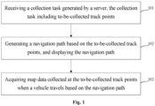
- a data collection method including: receiving a collection task generated by a server, where the collection task includes to-be-collected track points; generating a navigation path based on the to-be-collected track points, and displaying the navigation path; and acquiring map data collected at the to-be-collected track points when a vehicle travels based on the navigation path.
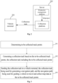
- a data collection method including: determining to-be-collected track points; generating a collection task based on the to-be-collected track points, where the collection task includes the to-be-collected track points; and sending the collection task to a vehicle terminal, where the collection task is used for generating a navigation path, and the navigation path is used for guiding a vehicle to travel and collect map data at the to-be-collected track points.
- a data collection apparatus including: a receiving module configured to receive a collection task generated by a server, where the collection task includes to-be-collected track points; a generating module configured to generate a navigation path based on the to-be-collected track points, and display the navigation path; and an acquiring module configured to acquire map data collected at the to-be-collected track points when a vehicle travels based on the navigation path.
- a data collection apparatus including: a determining module configured to determine to-be-collected track points; a task generating module configured to generate a collection task based on the to-be-collected track points, where the collection task includes the to-be-collected track points; and a sending module configured to send the collection task to a vehicle terminal, where the collection task is used for generating a navigation path, and the navigation path is used for guiding a vehicle to travel and collect map data at the to-be-collected track points.
- an electronic device including: at least one processor; and a memory connected with the at least one processor communicatively, where the memory stores instructions executable by the at least one processor to enable the at least one processor to perform the method according to any one of the above-mentioned aspects.
- a non-transitory computer readable storage medium with computer instructions stored thereon, where the computer instructions are used for causing a computer to perform the method according to any one of the above-mentioned aspects.
- a computer program product including a computer program which, when executed by a processor, implements the method according to any one of the above-mentioned aspects.
- an autonomous vehicle including the electronic device according to any one of the above-mentioned aspects.
- the technical solution according to the present disclosure may improve a data collection efficiency.
- every two persons use one vehicle to perform map data collection.
- One person is responsible for driving the vehicle, and the other person is responsible for planning a driving path and supervising a collection state.
- the method has a high cost and a low efficiency, and also has a collection missing problem.
- Fig. 1 is a schematic diagram according to a first embodiment of the present disclosure, and this embodiment provides a data collection method, including:
- An execution subject of this embodiment may be a data collection apparatus, and the apparatus may be software, hardware, or a combination of software and hardware.
- the apparatus may be located in an electronic device.
- the electronic device may be a user terminal, and the user terminal may include a mobile device (such as a mobile phone and a tablet computer), a vehicle-mounted terminal (such as an in-vehicle infotainment system), or the like.
- the in-vehicle infotainment system means an in-vehicle infotainment product mounted in a vehicle, and information communication between persons and vehicles and between vehicles and the outside (vehicles and vehicles) may be realized functionally by the in-vehicle infotainment system.
- the in-vehicle infotainment system may communicate with the server by a client installed on the in-vehicle infotainment system, and the client mounted on the in-vehicle infotainment system may be called a vehicle terminal.
- the server 202 may specifically include a collection platform and a production management platform, the production management platform may generate a data collection subproject (subproject for short) and send the subproject to the collection platform, and the collection platform may generate the collection task based on the subproject and send the collection task to the vehicle terminal 201.
- the vehicle terminal 201 may generate the navigation path based on the collection task, and guide the vehicle to travel based on the navigation path.
- the to-be-collected track points are track points where map data is to be collected, and may be appointed by a collector; for example, after logging in the collection platform, the collector appoints the to-be-collected track points in the collection task when the collection task is generated; usually, there are multiple to-be-collected track points, and the collector may also appoint a collection sequence of the multiple to-be-collected track points; for example, in the order of collection, the to-be-collected track points include point A, point B, point C, or the like.
- the navigation path may be generated based on the to-be-collected track points in the collection task.
- the collector receives the collection task on the vehicle terminal, and after the collection task is selected to be executed, the vehicle terminal may respond to an execution instruction of the collection task to generate the navigation path, and the navigation path is displayed to the collector on a display interface of the vehicle terminal.
- the collection task may include the collection sequence of the to-be-collected track points, and the navigation path between every two points may be generated sequentially; for example, a starting point of the vehicle is represented by point O, and assuming that the to-be-collected track points are point A, point B and point C in sequence, the navigation paths between OA, between AB, and between BC are generated sequentially.
- the navigation path between every two points may be implemented based on a related technology; for example, the vehicle terminal may send a navigation path planning request to a server of a map APP, and the server of the map APP may plan the navigation path between the two points based on the related technology and feed the navigation path back to the in-vehicle infotainment system.
- the collector may control the vehicle to travel along the navigation path based on the navigation path.
- the collection task may also include a sensor type, and a corresponding sensor is selected to collect data based on the sensor type; for example, if the sensor type means a laser radar, a laser radar is used for collecting data, such as a point cloud of the surrounding environment collected by the laser radar; or, if the sensor type means a camera, a camera is used to collect data, such as pictures of the surrounding environment collected by the camera, or the like. It may be understood that there may exist one or more sensor types, such that one or more sensors may be used for data collection, thereby obtaining one or more types of map data.
- the collection, storage, usage, processing, transmission, provision, disclosure, or the like, of involved user personal information are in compliance with relevant laws and regulations, and do not violate public order and good customs.
- the collection task of the server is received, the navigation path is generated based on the collection task, and no specially-assigned person is required to plan the navigation path, thereby realizing a one-vehicle and one-person data collection method, and improving a data collection efficiency.
- the method further includes: thinning the map data to obtain thinned data; and saving the thinned data.
- the thinning operation means that the map data is selected at intervals, such that a data size of the selected map data is less than that of the original map data; for example, the original map data includes: map data at point A, map data at point B, map data at point C and map data at point D, and the thinned data may include: the map data at point A and the map data at point C.
- the thinned data may be saved after acquired.
- the thinned data may be saved in a memory, such as a double data rate (DDR) synchronous dynamic random access memory, or a non-volatile memory, such as an embedded multimedia card (eMMC).
- DDR double data rate
- eMMC embedded multimedia card
- the method further includes: displaying the collected track points on the navigation path in a specific manner.
- the specific manner is a preset display manner, for example, highlighted display.
- point A may be displayed in a highlighted manner.
- the collected track points are displayed in the specific manner, such that the collector may know collected information visually, and subsequent processing operations of the collector are facilitated.
- the collection task is generated based on a subproject range of the data collection subproject, and the method further includes: generating a collected track based on the collected track points; and uploading the collected track to the server, where the collected track is used for updating the subproject range in the server.
- the data collection subproject may be generated by the server, each subproject corresponds to one subproject range, and the subproject range may be a certain administrative region, a certain polygonal region, or the like.
- the server may also have road network data, thereby obtaining road network data in the subproject range.
- a road network refers to a network in a certain region in which various roads are interconnected and interlaced into mesh distribution.
- the road network data is used for describing the road network, and may include road data in the corresponding road network.
- the collected track points may be connected into the collected track after obtained, and the collected track is matched with the road in the subproject range; for example, the subproject range initially includes road X, road Y and road Z, and assuming that the collected track is matched with road X, the subproject range may be updated to road Y and road Z.
- various related technologies may be used for the matching operation; for example, if the collected track is located in a certain road, the road is used as the matched road.
- Fig. 3 is a schematic diagram according to a third embodiment of the present disclosure, and this embodiment takes the execution at the server as an example, and provides a data collection method, including:
- An execution subject of 301 to 303 may be a collection platform of the server specifically.
- a collector may appoint the to-be-collected track points; for example, the collection platform may receive a data collection subproject, the subproject may include a subproject range (for example, a certain administrative region), and the collector may appoint the to-be-collected track points in the subproject range.
- the collection platform may receive a data collection subproject
- the subproject may include a subproject range (for example, a certain administrative region)
- the collector may appoint the to-be-collected track points in the subproject range.
- the collection task is sent to the vehicle terminal, such that the navigation path may be generated by the vehicle terminal based on the collection task, and no specially-assigned person is required to plan the navigation path, thereby realizing a one-vehicle and one-person data collection method, and improving a data collection efficiency.
- the collector appoints the to-be-collected track points, and individual requirements of the collector may be met.
- the method further includes:
- the selectable data collection subprojects include: subproject-1, subproject-2, subproject-3, or the like, and the selectable subprojects may be displayed; the collector may select one subproject from the multiple selectable data collection subprojects as the to-be-adopted data collection subproject according to personal requirements, for example, selects subproject-1 as the to-be-adopted data collection subproject.
- Each subproject may correspond to a respective subproject range; for example, the subproject range of subproject-1 is region-1, the subproject range of subproject-2 is region-2, or the like, and when subproject-1 is the to-be-adopted data collection subproject, region-1 may be displayed, such that the collector may appoint the to-be-collected track points in region-1.
- the selectable subproject may be provided for the collector, and by displaying the subproject range, the collector may appoint the to-be-collected track points in the subproject range.
- the above operation of displaying the selectable data collection subproject and the subproject range may also be performed by the collection platform of the server specifically.
- the method further includes:
- the operations of creating the data collection project (project for short) and dividing the project into the subprojects may be performed by a production management platform in the server.
- the demander may provide the data collection requirement; for example, map data of a certain city (such as city Q) is required to be collected, the production management platform may create a data collection project corresponding to city Q, and a project range is a geographic region range of city Q.
- map data of a certain city such as city Q
- the production management platform may create a data collection project corresponding to city Q
- a project range is a geographic region range of city Q.
- the project range may be divided after determined by the production management platform; for example, the geographic region range of city Q is divided according to administrative regions, and the whole geographic region range of city Q is divided into region Q1, region Q2, or the like.
- a corresponding subproject may be generated; for example, a subproject corresponding to Q1, a subproject corresponding to Q2, or the like, are generated, and the subprojects may be provided for the collector as the selectable subprojects.
- Fig. 4 is a schematic diagram according to a fourth embodiment of the present disclosure, this embodiment provides a data collection method and takes interaction between the server and the vehicle terminal as an example, the server includes a production management platform and a collection platform, and the method includes:
- the data collection project is referred to as the project for short
- the data collection subproject is referred to as the subproject for short for description.
- the production management platform may perform the following operations:
- An administrator is a user of the production management platform, and after login, may create the project and divide the project to obtain the subprojects.
- the collection platform may perform the following operations:
- a collector is a user of the collection platform, and after login, may receive the subproject; that is, at this point, the received subproject is used to indicate the subproject selected by the collector from the multiple selectable subprojects.
- the vehicle terminal may perform the following operation: 701: vehicle terminal collection.
- Execution content of vehicle terminal collection may be shown in 101 to 103, and the specific execution content may be shown in Fig. 7 .
- the server may generate the project, the subproject and the collection task based on road network data of the server, and the road network data is not required to be sent to a navigator of the vehicle, such that offline circulation of the road network data may be avoided, and risks may be managed and controlled.
- the vehicle terminal may generate the navigation path based on the collection task, and manual navigation is not required, thereby reducing a cost and improving an efficiency.
- the map data of the to-be-collected track points is obtained, and the collected track points are displayed, thus avoiding collection missing.
- Fig. 8 is a schematic diagram according to an eighth embodiment of the present disclosure, which provides a data collection apparatus.
- the apparatus 800 includes: a receiving module 801, a generating module 802 and an acquiring module 803.
- the receiving module 801 is configured to receive a collection task generated by a server, where the collection task includes to-be-collected track points; the generating module 802 is configured to generate a navigation path based on the to-be-collected track points, and display the navigation path; and the acquiring module 803 is configured to acquire map data collected at the to-be-collected track points when a vehicle travels based on the navigation path.
- the apparatus 800 further includes: a thinning module configured to thin the map data to obtain thinned data; and a saving module configured to save the thinned data.
- the apparatus 800 further includes: a displaying module configured to display the collected track points on the navigation path in a specific manner.
- the collection task is generated based on a subproject range of the data collection subproject
- the apparatus further includes: an updating module configured to generate a collected track based on the collected track points; and upload the collected track to the server, where the collected track is used for updating the subproject range in the server.
- the collection task of the server is received, the navigation path is generated based on the collection task, and no specially-assigned person is required to plan the navigation path, thereby realizing a one-vehicle and one-person data collection method, and improving a data collection efficiency.
- Fig. 9 is a schematic diagram according to an eighth embodiment of the present disclosure, which provides a data collection apparatus.
- the apparatus 900 includes: a determining module 901, a task generating module 902 and a sending module 903.
- the determining module 901 is configured to determine to-be-collected track points; the task generating module 902 is configured to generate a collection task based on the to-be-collected track points, where the collection task includes the to-be-collected track points; and the sending module 903 is configured to send the collection task to a vehicle terminal, where the collection task is used for generating a navigation path, and the navigation path is used for guiding a vehicle to travel and collect map data at the to-be-collected track points.
- the determining module 901 is specifically configured to: acquire to-be-collected track points appointed by a collector in a subproject range.
- the apparatus 900 further includes: a first displaying module configured to display selectable data collection subprojects; a selecting module configured to select a to-be-adopted data collection subproject from the selectable data collection subprojects, where the to-be-adopted data collection subproject includes a subproject range; and a second displaying module configured to display the subproject range of the to-be-adopted data collection subproject.
- the apparatus 900 further includes: a creating module configured to create a data collection project based on a data collection requirement of a demander, where the data collection project includes a project range; a dividing module configured to divide the project range into multiple subproject ranges; and a subproject generating module configured to generate the selectable data collection subproject based on the subproject range.
- the collection task is sent to the vehicle terminal, such that the navigation path may be generated by the vehicle terminal based on the collection task, and no specially-assigned person is required to plan the navigation path, thereby realizing a one-vehicle and one-person data collection method, and improving a data collection efficiency.
- the collection, storage, usage, processing, transmission, provision, disclosure, or the like, of involved user personal information are in compliance with relevant laws and regulations, and do not violate public order and good customs.
- an electronic device a readable storage medium and a computer program product.
- the present disclosure further provides an autonomous vehicle, including the above-mentioned electronic device.
- Fig. 10 shows a schematic block diagram of an exemplary electronic device 1000 which may be configured to implement the embodiment of the present disclosure.
- the electronic device is intended to represent various forms of digital computers, such as laptop computers, desktop computers, workstations, servers, blade servers, mainframe computers, and other appropriate computers.
- the electronic device may also represent various forms of mobile apparatuses, such as personal digital assistants, cellular telephones, smart phones, wearable devices, and other similar computing apparatuses.
- the components shown herein, their connections and relationships, and their functions, are meant to be exemplary only, and are not meant to limit implementation of the present disclosure described and/or claimed herein.
- the electronic device 1000 includes a computing unit 1001 which may perform various appropriate actions and processing operations according to a computer program stored in a read only memory (ROM) 1002 or a computer program loaded from a storage unit 1008 into a random access memory (RAM) 1003.
- ROM read only memory
- RAM random access memory
- Various programs and data necessary for the operation of the electronic device 1000 may be also stored in the RAM 1003.
- the computing unit 1001, the ROM 1002, and the RAM 1003 are connected with one other through a bus 1004.
- An input/output (I/O) interface 1005 is also connected to the bus 1004.
- the multiple components in the electronic device 1000 are connected to the I/O interface 1005, and include: an input unit 1006, such as a keyboard, a mouse, or the like; an output unit 1007, such as various types of displays, speakers, or the like; the storage unit 1008, such as a magnetic disk, an optical disk, or the like; and a communication unit 1009, such as a network card, a modem, a wireless communication transceiver, or the like.
- the communication unit 1009 allows the electronic device 1000 to exchange information/data with other devices through a computer network, such as the Internet, and/or various telecommunication networks.
- the computing unit 1001 may be a variety of general and/or special purpose processing components with processing and computing capabilities. Some examples of the computing unit 1001 include, but are not limited to, a central processing unit (CPU), a graphic processing unit (GPU), various dedicated artificial intelligence (AI) computing chips, various computing units running machine learning model algorithms, a digital signal processor (DSP), and any suitable processor, controller, microcontroller, or the like.
- the computing unit 1001 performs the methods and processing operations described above, such as the data collection method.
- the data collection method may be implemented as a computer software program tangibly contained in a machine readable medium, such as the storage unit 1008.
- part or all of the computer program may be loaded and/or installed into the electronic device 1000 via the ROM 1002 and/or the communication unit 1009.
- the computer program When the computer program is loaded into the RAM 1003 and executed by the computing unit 1001, one or more steps of the data collection method described above may be performed.
- the computing unit 1001 may be configured to perform the data collection method by any other suitable means (for example, by means of firmware).
- Various implementations of the systems and technologies described herein above may be implemented in digital electronic circuitry, integrated circuitry, field programmable gate arrays (FPGA), application specific integrated circuits (ASIC), application specific standard products (ASSP), systems on chips (SOC), complex programmable logic devices (CPLD), computer hardware, firmware, software, and/or combinations thereof.
- the systems and technologies may be implemented in one or more computer programs which are executable and/or interpretable on a programmable system including at least one programmable processor, and the programmable processor may be special or general, and may receive data and instructions from, and transmit data and instructions to, a storage system, at least one input apparatus, and at least one output apparatus.
- Program codes for implementing the method according to the present disclosure may be written in any combination of one or more programming languages. These program codes may be provided to a processor or a controller of a general purpose computer, a special purpose computer, or other programmable map data collection apparatuses, such that the program code, when executed by the processor or the controller, causes functions/operations specified in the flowchart and/or the block diagram to be implemented.
- the program code may be executed entirely on a machine, partly on a machine, partly on a machine as a stand-alone software package and partly on a remote machine, or entirely on a remote machine or a server.
- the machine readable medium may be a tangible medium which may contain or store a program for use by or in connection with an instruction execution system, apparatus, or device.
- the machine readable medium may be a machine readable signal medium or a machine readable storage medium.
- the machine readable medium may include, but is not limited to, an electronic, magnetic, optical, electromagnetic, infrared, or semiconductor system, apparatus, or device, or any suitable combination of the foregoing.
- machine readable storage medium may include an electrical connection based on one or more wires, a portable computer disk, a hard disk, a random access memory (RAM), a read only memory (ROM), an erasable programmable read only memory (EPROM or flash memory), an optical fiber, a portable compact disc read only memory (CD-ROM), an optical storage device, a magnetic storage device, or any suitable combination of the foregoing.
- RAM random access memory
- ROM read only memory
- EPROM or flash memory erasable programmable read only memory
- CD-ROM compact disc read only memory
- magnetic storage device or any suitable combination of the foregoing.
- a computer having: a display apparatus (for example, a cathode ray tube (CRT) or liquid crystal display (LCD) monitor) for displaying information to a user; and a keyboard and a pointing apparatus (for example, a mouse or a trackball) by which a user may provide input for the computer.
- a display apparatus for example, a cathode ray tube (CRT) or liquid crystal display (LCD) monitor
- a keyboard and a pointing apparatus for example, a mouse or a trackball
- Other kinds of apparatuses may also be used to provide interaction with a user; for example, feedback provided for a user may be any form of sensory feedback (for example, visual feedback, auditory feedback, or tactile feedback); and input from a user may be received in any form (including acoustic, speech or tactile input).
- the systems and technologies described here may be implemented in a computing system (for example, as a data server) which includes a back-end component, or a computing system (for example, an application server) which includes a middleware component, or a computing system (for example, a user computer having a graphical user interface or a web browser through which a user may interact with an implementation of the systems and technologies described here) which includes a front-end component, or a computing system which includes any combination of such back-end, middleware, or front-end components.
- the components of the system may be interconnected through any form or medium of digital data communication (for example, a communication network). Examples of the communication network include: a local area network (LAN), a wide area network (WAN) and the Internet.
- a computer system may include a client and a server.
- the client and the server are remote from each other and interact through the communication network.
- the relationship between the client and the server is generated by virtue of computer programs which run on respective computers and have a client-server relationship to each other.
- the server may be a cloud server, also called a cloud computing server or a cloud host, and is a host product in a cloud computing service system, so as to overcome the defects of high management difficulty and weak service expansibility in conventional physical host and virtual private server (VPS) service.
- the server may also be a server of a distributed system, or a server incorporating a blockchain.
Landscapes
- Engineering & Computer Science (AREA)
- Radar, Positioning & Navigation (AREA)
- Remote Sensing (AREA)
- Physics & Mathematics (AREA)
- General Physics & Mathematics (AREA)
- Automation & Control Theory (AREA)
- Chemical & Material Sciences (AREA)
- Analytical Chemistry (AREA)
- Databases & Information Systems (AREA)
- Business, Economics & Management (AREA)
- Tourism & Hospitality (AREA)
- Strategic Management (AREA)
- Navigation (AREA)
- General Health & Medical Sciences (AREA)
- Human Resources & Organizations (AREA)
- Marketing (AREA)
- Primary Health Care (AREA)
- General Business, Economics & Management (AREA)
- Mathematical Physics (AREA)
- Economics (AREA)
- Theoretical Computer Science (AREA)
- Health & Medical Sciences (AREA)
- Information Retrieval, Db Structures And Fs Structures Therefor (AREA)
- Instructional Devices (AREA)
- Operations Research (AREA)
Applications Claiming Priority (1)
| Application Number | Priority Date | Filing Date | Title |
|---|---|---|---|
| CN202111334511.3A CN114323039B (zh) | 2021-11-11 | 2021-11-11 | 高精地图的数据采集方法、装置、车辆、设备和存储介质 |
Publications (1)
| Publication Number | Publication Date |
|---|---|
| EP4180765A1 true EP4180765A1 (de) | 2023-05-17 |
Family
ID=81044931
Family Applications (1)
| Application Number | Title | Priority Date | Filing Date |
|---|---|---|---|
| EP22202441.6A Withdrawn EP4180765A1 (de) | 2021-11-11 | 2022-10-19 | Verfahren und system zur sammlung von hochpräzisen kartendaten |
Country Status (5)
| Country | Link |
|---|---|
| US (1) | US20230147521A1 (de) |
| EP (1) | EP4180765A1 (de) |
| JP (1) | JP7419645B2 (de) |
| KR (1) | KR20230068994A (de) |
| CN (1) | CN114323039B (de) |
Families Citing this family (2)
| Publication number | Priority date | Publication date | Assignee | Title |
|---|---|---|---|---|
| CN115049288A (zh) * | 2022-06-20 | 2022-09-13 | 北京京东振世信息技术有限公司 | 轨迹生成方法、装置、设备及介质 |
| CN119459771B (zh) * | 2024-09-30 | 2026-01-27 | 广州汽车集团股份有限公司 | 车辆控制方法、装置、车辆及存储介质 |
Citations (5)
| Publication number | Priority date | Publication date | Assignee | Title |
|---|---|---|---|---|
| CN108932331A (zh) * | 2018-07-05 | 2018-12-04 | 腾讯科技(深圳)有限公司 | 一种地图数据更新方法、装置及系统 |
| US20200208994A1 (en) * | 2016-10-28 | 2020-07-02 | Zoox, Inc. | Verification and updating of map data |
| EP3696510A2 (de) * | 2019-02-14 | 2020-08-19 | HERE Global B.V. | Verfahren, vorrichtung und system zur bereitstellung einer kampagnenverwaltungsplattform zum auffinden von kartendaten |
| US20210302170A1 (en) * | 2020-03-31 | 2021-09-30 | Gm Cruise Holdings Llc | Map maintenance and verification |
| US20210302981A1 (en) * | 2020-03-31 | 2021-09-30 | Gm Cruise Holdings Llc | Proactive waypoints for accelerating autonomous vehicle testing |
Family Cites Families (10)
| Publication number | Priority date | Publication date | Assignee | Title |
|---|---|---|---|---|
| JP3392116B2 (ja) | 2000-10-03 | 2003-03-31 | パイオニア株式会社 | ナビゲーション装置 |
| CN102136162B (zh) * | 2010-12-25 | 2015-11-18 | 江西九江供电公司 | 一种输电线路巡检系统 |
| CN103455634A (zh) * | 2013-09-24 | 2013-12-18 | 国家电网公司 | 一种基于移动设备的电力gis数据采集系统及方法 |
| JP2016217820A (ja) | 2015-05-19 | 2016-12-22 | 日産自動車株式会社 | 経路案内装置 |
| JP2016223790A (ja) | 2015-05-27 | 2016-12-28 | 日産自動車株式会社 | 経路案内装置 |
| CN108267152B (zh) * | 2016-12-31 | 2020-11-10 | 中国移动通信集团辽宁有限公司 | 确定导航地图的方法及装置 |
| CN108549370A (zh) | 2018-03-23 | 2018-09-18 | 西安理工大学 | 数据采集方法及采集装置 |
| JP7064463B2 (ja) | 2019-03-22 | 2022-05-10 | 株式会社ゼンリンデータコム | ルート関連情報取得装置およびルート関連情報取得方法 |
| CN111192341A (zh) * | 2019-12-31 | 2020-05-22 | 北京三快在线科技有限公司 | 生成高精地图的方法、装置、自动驾驶设备及存储介质 |
| CN111928863A (zh) * | 2020-08-20 | 2020-11-13 | 新石器慧义知行智驰(北京)科技有限公司 | 一种高精地图数据采集方法、装置及系统 |
-
2021
- 2021-11-11 CN CN202111334511.3A patent/CN114323039B/zh active Active
-
2022
- 2022-10-17 US US18/047,186 patent/US20230147521A1/en not_active Abandoned
- 2022-10-18 KR KR1020220134113A patent/KR20230068994A/ko not_active Withdrawn
- 2022-10-18 JP JP2022166864A patent/JP7419645B2/ja active Active
- 2022-10-19 EP EP22202441.6A patent/EP4180765A1/de not_active Withdrawn
Patent Citations (5)
| Publication number | Priority date | Publication date | Assignee | Title |
|---|---|---|---|---|
| US20200208994A1 (en) * | 2016-10-28 | 2020-07-02 | Zoox, Inc. | Verification and updating of map data |
| CN108932331A (zh) * | 2018-07-05 | 2018-12-04 | 腾讯科技(深圳)有限公司 | 一种地图数据更新方法、装置及系统 |
| EP3696510A2 (de) * | 2019-02-14 | 2020-08-19 | HERE Global B.V. | Verfahren, vorrichtung und system zur bereitstellung einer kampagnenverwaltungsplattform zum auffinden von kartendaten |
| US20210302170A1 (en) * | 2020-03-31 | 2021-09-30 | Gm Cruise Holdings Llc | Map maintenance and verification |
| US20210302981A1 (en) * | 2020-03-31 | 2021-09-30 | Gm Cruise Holdings Llc | Proactive waypoints for accelerating autonomous vehicle testing |
Also Published As
| Publication number | Publication date |
|---|---|
| US20230147521A1 (en) | 2023-05-11 |
| CN114323039A (zh) | 2022-04-12 |
| CN114323039B (zh) | 2023-10-27 |
| JP2023071599A (ja) | 2023-05-23 |
| KR20230068994A (ko) | 2023-05-18 |
| JP7419645B2 (ja) | 2024-01-23 |
Similar Documents
| Publication | Publication Date | Title |
|---|---|---|
| EP3967980B1 (de) | Routenverarbeitungsverfahren und -vorrichtung | |
| EP4119896A2 (de) | Verfahren und vorrichtung zur verarbeitung hochauflösender kartendaten, elektronische vorrichtung, medium und produkt | |
| US12209873B2 (en) | Method and apparatus for unmanned vehicle dispatching management, device, storage medium and program | |
| US20230058261A1 (en) | Navigation processing method and apparatus, service side device, intelligent terminal, and storage medium | |
| JP7258938B2 (ja) | 交差点仮想レーンをマークする方法、交差点仮想レーンをマークする装置、電子機器、コンピュータ可読記憶媒体及びコンピュータプログラム | |
| CN114187412B (zh) | 高精地图生成方法、装置、电子设备及存储介质 | |
| CN113868532B (zh) | 一种地点推荐方法、装置、电子设备及存储介质 | |
| EP4180765A1 (de) | Verfahren und system zur sammlung von hochpräzisen kartendaten | |
| CN113139118A (zh) | 停车场推荐方法、装置、电子设备和介质 | |
| EP4187205A2 (de) | Navigationsverfahren und -vorrichtung und medium | |
| CN111597287A (zh) | 地图生成方法、装置及设备 | |
| CN106846881A (zh) | 共享车辆方法、装置及系统 | |
| CN114238790A (zh) | 用于确定最大感知范围的方法、装置、设备以及存储介质 | |
| CN113420235A (zh) | 地图查询方法、装置及电子设备 | |
| CN113868554A (zh) | 一种路线推荐方法、装置、电子设备和存储介质 | |
| US11244400B1 (en) | Representing investment options as travel options on a map | |
| US20220381574A1 (en) | Multipath generation method, apparatus, device and storage medium | |
| WO2020185442A1 (en) | Computerized vehicle delivery coordination | |
| CN115410410A (zh) | 车位推荐方法、装置、设备以及存储介质 | |
| CN115691206B (zh) | 车位推荐方法、装置、设备以及存储介质 | |
| CN114166231A (zh) | 众包数据采集方法、装置、设备、存储介质以及程序产品 | |
| CN115412595A (zh) | 一种请求处理方法、装置、电子设备及存储介质 | |
| CN121067889A (zh) | 一种高精地图匹配方法、装置、电子设备及存储介质 | |
| CN115062240A (zh) | 一种停车场排序方法、装置、电子设备和存储介质 | |
| CN115098607A (zh) | 地图数据融合方法、装置、电子设备及存储介质 |
Legal Events
| Date | Code | Title | Description |
|---|---|---|---|
| PUAI | Public reference made under article 153(3) epc to a published international application that has entered the european phase |
Free format text: ORIGINAL CODE: 0009012 |
|
| STAA | Information on the status of an ep patent application or granted ep patent |
Free format text: STATUS: REQUEST FOR EXAMINATION WAS MADE |
|
| 17P | Request for examination filed |
Effective date: 20221019 |
|
| AK | Designated contracting states |
Kind code of ref document: A1 Designated state(s): AL AT BE BG CH CY CZ DE DK EE ES FI FR GB GR HR HU IE IS IT LI LT LU LV MC ME MK MT NL NO PL PT RO RS SE SI SK SM TR |
|
| STAA | Information on the status of an ep patent application or granted ep patent |
Free format text: STATUS: THE APPLICATION HAS BEEN WITHDRAWN |
|
| 18W | Application withdrawn |
Effective date: 20240311 |