EP4235211A1 - Rétroflecteur sur des véhicules autonomes pour caméra d'amis automatisée, détection et télémétrie de lumière, et étalonnage de détection et de télémétrie radio - Google Patents
Rétroflecteur sur des véhicules autonomes pour caméra d'amis automatisée, détection et télémétrie de lumière, et étalonnage de détection et de télémétrie radio Download PDFInfo
- Publication number
- EP4235211A1 EP4235211A1 EP23151302.9A EP23151302A EP4235211A1 EP 4235211 A1 EP4235211 A1 EP 4235211A1 EP 23151302 A EP23151302 A EP 23151302A EP 4235211 A1 EP4235211 A1 EP 4235211A1
- Authority
- EP
- European Patent Office
- Prior art keywords
- data
- location
- associated vehicle
- features
- sensors
- Prior art date
- Legal status (The legal status is an assumption and is not a legal conclusion. Google has not performed a legal analysis and makes no representation as to the accuracy of the status listed.)
- Withdrawn
Links
Images


Classifications
-
- B—PERFORMING OPERATIONS; TRANSPORTING
- B60—VEHICLES IN GENERAL
- B60W—CONJOINT CONTROL OF VEHICLE SUB-UNITS OF DIFFERENT TYPE OR DIFFERENT FUNCTION; CONTROL SYSTEMS SPECIALLY ADAPTED FOR HYBRID VEHICLES; ROAD VEHICLE DRIVE CONTROL SYSTEMS FOR PURPOSES NOT RELATED TO THE CONTROL OF A PARTICULAR SUB-UNIT
- B60W50/00—Details of control systems for road vehicle drive control not related to the control of a particular sub-unit, e.g. process diagnostic or vehicle driver interfaces
- B60W50/02—Ensuring safety in case of control system failures, e.g. by diagnosing, circumventing or fixing failures
- B60W50/0225—Failure correction strategy
-
- G—PHYSICS
- G01—MEASURING; TESTING
- G01S—RADIO DIRECTION-FINDING; RADIO NAVIGATION; DETERMINING DISTANCE OR VELOCITY BY USE OF RADIO WAVES; LOCATING OR PRESENCE-DETECTING BY USE OF THE REFLECTION OR RERADIATION OF RADIO WAVES; ANALOGOUS ARRANGEMENTS USING OTHER WAVES
- G01S13/00—Systems using the reflection or reradiation of radio waves, e.g. radar systems; Analogous systems using reflection or reradiation of waves whose nature or wavelength is irrelevant or unspecified
- G01S13/88—Radar or analogous systems specially adapted for specific applications
- G01S13/93—Radar or analogous systems specially adapted for specific applications for anti-collision purposes
- G01S13/931—Radar or analogous systems specially adapted for specific applications for anti-collision purposes of land vehicles
-
- B—PERFORMING OPERATIONS; TRANSPORTING
- B60—VEHICLES IN GENERAL
- B60W—CONJOINT CONTROL OF VEHICLE SUB-UNITS OF DIFFERENT TYPE OR DIFFERENT FUNCTION; CONTROL SYSTEMS SPECIALLY ADAPTED FOR HYBRID VEHICLES; ROAD VEHICLE DRIVE CONTROL SYSTEMS FOR PURPOSES NOT RELATED TO THE CONTROL OF A PARTICULAR SUB-UNIT
- B60W50/00—Details of control systems for road vehicle drive control not related to the control of a particular sub-unit, e.g. process diagnostic or vehicle driver interfaces
- B60W50/02—Ensuring safety in case of control system failures, e.g. by diagnosing, circumventing or fixing failures
- B60W50/0205—Diagnosing or detecting failures; Failure detection models
-
- G—PHYSICS
- G01—MEASURING; TESTING
- G01S—RADIO DIRECTION-FINDING; RADIO NAVIGATION; DETERMINING DISTANCE OR VELOCITY BY USE OF RADIO WAVES; LOCATING OR PRESENCE-DETECTING BY USE OF THE REFLECTION OR RERADIATION OF RADIO WAVES; ANALOGOUS ARRANGEMENTS USING OTHER WAVES
- G01S13/00—Systems using the reflection or reradiation of radio waves, e.g. radar systems; Analogous systems using reflection or reradiation of waves whose nature or wavelength is irrelevant or unspecified
- G01S13/86—Combinations of radar systems with non-radar systems, e.g. sonar, direction finder
- G01S13/865—Combination of radar systems with lidar systems
-
- G—PHYSICS
- G01—MEASURING; TESTING
- G01S—RADIO DIRECTION-FINDING; RADIO NAVIGATION; DETERMINING DISTANCE OR VELOCITY BY USE OF RADIO WAVES; LOCATING OR PRESENCE-DETECTING BY USE OF THE REFLECTION OR RERADIATION OF RADIO WAVES; ANALOGOUS ARRANGEMENTS USING OTHER WAVES
- G01S13/00—Systems using the reflection or reradiation of radio waves, e.g. radar systems; Analogous systems using reflection or reradiation of waves whose nature or wavelength is irrelevant or unspecified
- G01S13/86—Combinations of radar systems with non-radar systems, e.g. sonar, direction finder
- G01S13/867—Combination of radar systems with cameras
-
- G—PHYSICS
- G01—MEASURING; TESTING
- G01S—RADIO DIRECTION-FINDING; RADIO NAVIGATION; DETERMINING DISTANCE OR VELOCITY BY USE OF RADIO WAVES; LOCATING OR PRESENCE-DETECTING BY USE OF THE REFLECTION OR RERADIATION OF RADIO WAVES; ANALOGOUS ARRANGEMENTS USING OTHER WAVES
- G01S17/00—Systems using the reflection or reradiation of electromagnetic waves other than radio waves, e.g. lidar systems
- G01S17/86—Combinations of lidar systems with systems other than lidar, radar or sonar, e.g. with direction finders
-
- G—PHYSICS
- G01—MEASURING; TESTING
- G01S—RADIO DIRECTION-FINDING; RADIO NAVIGATION; DETERMINING DISTANCE OR VELOCITY BY USE OF RADIO WAVES; LOCATING OR PRESENCE-DETECTING BY USE OF THE REFLECTION OR RERADIATION OF RADIO WAVES; ANALOGOUS ARRANGEMENTS USING OTHER WAVES
- G01S17/00—Systems using the reflection or reradiation of electromagnetic waves other than radio waves, e.g. lidar systems
- G01S17/88—Lidar systems specially adapted for specific applications
- G01S17/93—Lidar systems specially adapted for specific applications for anti-collision purposes
- G01S17/931—Lidar systems specially adapted for specific applications for anti-collision purposes of land vehicles
-
- G—PHYSICS
- G01—MEASURING; TESTING
- G01S—RADIO DIRECTION-FINDING; RADIO NAVIGATION; DETERMINING DISTANCE OR VELOCITY BY USE OF RADIO WAVES; LOCATING OR PRESENCE-DETECTING BY USE OF THE REFLECTION OR RERADIATION OF RADIO WAVES; ANALOGOUS ARRANGEMENTS USING OTHER WAVES
- G01S7/00—Details of systems according to groups G01S13/00, G01S15/00, G01S17/00
- G01S7/003—Transmission of data between radar, sonar or lidar systems and remote stations
-
- G—PHYSICS
- G01—MEASURING; TESTING
- G01S—RADIO DIRECTION-FINDING; RADIO NAVIGATION; DETERMINING DISTANCE OR VELOCITY BY USE OF RADIO WAVES; LOCATING OR PRESENCE-DETECTING BY USE OF THE REFLECTION OR RERADIATION OF RADIO WAVES; ANALOGOUS ARRANGEMENTS USING OTHER WAVES
- G01S7/00—Details of systems according to groups G01S13/00, G01S15/00, G01S17/00
- G01S7/02—Details of systems according to groups G01S13/00, G01S15/00, G01S17/00 of systems according to group G01S13/00
- G01S7/40—Means for monitoring or calibrating
- G01S7/4004—Means for monitoring or calibrating of parts of a radar system
- G01S7/4026—Antenna boresight
- G01S7/403—Antenna boresight in azimuth, i.e. in the horizontal plane
-
- G—PHYSICS
- G01—MEASURING; TESTING
- G01S—RADIO DIRECTION-FINDING; RADIO NAVIGATION; DETERMINING DISTANCE OR VELOCITY BY USE OF RADIO WAVES; LOCATING OR PRESENCE-DETECTING BY USE OF THE REFLECTION OR RERADIATION OF RADIO WAVES; ANALOGOUS ARRANGEMENTS USING OTHER WAVES
- G01S7/00—Details of systems according to groups G01S13/00, G01S15/00, G01S17/00
- G01S7/02—Details of systems according to groups G01S13/00, G01S15/00, G01S17/00 of systems according to group G01S13/00
- G01S7/40—Means for monitoring or calibrating
- G01S7/4004—Means for monitoring or calibrating of parts of a radar system
- G01S7/4026—Antenna boresight
- G01S7/4034—Antenna boresight in elevation, i.e. in the vertical plane
-
- G—PHYSICS
- G01—MEASURING; TESTING
- G01S—RADIO DIRECTION-FINDING; RADIO NAVIGATION; DETERMINING DISTANCE OR VELOCITY BY USE OF RADIO WAVES; LOCATING OR PRESENCE-DETECTING BY USE OF THE REFLECTION OR RERADIATION OF RADIO WAVES; ANALOGOUS ARRANGEMENTS USING OTHER WAVES
- G01S7/00—Details of systems according to groups G01S13/00, G01S15/00, G01S17/00
- G01S7/02—Details of systems according to groups G01S13/00, G01S15/00, G01S17/00 of systems according to group G01S13/00
- G01S7/40—Means for monitoring or calibrating
- G01S7/4052—Means for monitoring or calibrating by simulation of echoes
- G01S7/4082—Means for monitoring or calibrating by simulation of echoes using externally generated reference signals, e.g. via remote reflector or transponder
- G01S7/4091—Means for monitoring or calibrating by simulation of echoes using externally generated reference signals, e.g. via remote reflector or transponder during normal radar operation
-
- G—PHYSICS
- G01—MEASURING; TESTING
- G01S—RADIO DIRECTION-FINDING; RADIO NAVIGATION; DETERMINING DISTANCE OR VELOCITY BY USE OF RADIO WAVES; LOCATING OR PRESENCE-DETECTING BY USE OF THE REFLECTION OR RERADIATION OF RADIO WAVES; ANALOGOUS ARRANGEMENTS USING OTHER WAVES
- G01S7/00—Details of systems according to groups G01S13/00, G01S15/00, G01S17/00
- G01S7/48—Details of systems according to groups G01S13/00, G01S15/00, G01S17/00 of systems according to group G01S17/00
- G01S7/497—Means for monitoring or calibrating
-
- G—PHYSICS
- G01—MEASURING; TESTING
- G01S—RADIO DIRECTION-FINDING; RADIO NAVIGATION; DETERMINING DISTANCE OR VELOCITY BY USE OF RADIO WAVES; LOCATING OR PRESENCE-DETECTING BY USE OF THE REFLECTION OR RERADIATION OF RADIO WAVES; ANALOGOUS ARRANGEMENTS USING OTHER WAVES
- G01S7/00—Details of systems according to groups G01S13/00, G01S15/00, G01S17/00
- G01S7/48—Details of systems according to groups G01S13/00, G01S15/00, G01S17/00 of systems according to group G01S17/00
- G01S7/497—Means for monitoring or calibrating
- G01S7/4972—Alignment of sensor
-
- G—PHYSICS
- G06—COMPUTING OR CALCULATING; COUNTING
- G06T—IMAGE DATA PROCESSING OR GENERATION, IN GENERAL
- G06T7/00—Image analysis
- G06T7/80—Analysis of captured images to determine intrinsic or extrinsic camera parameters, i.e. camera calibration
-
- G—PHYSICS
- G07—CHECKING-DEVICES
- G07C—TIME OR ATTENDANCE REGISTERS; REGISTERING OR INDICATING THE WORKING OF MACHINES; GENERATING RANDOM NUMBERS; VOTING OR LOTTERY APPARATUS; ARRANGEMENTS, SYSTEMS OR APPARATUS FOR CHECKING NOT PROVIDED FOR ELSEWHERE
- G07C5/00—Registering or indicating the working of vehicles
- G07C5/008—Registering or indicating the working of vehicles communicating information to a remotely located station
-
- B—PERFORMING OPERATIONS; TRANSPORTING
- B60—VEHICLES IN GENERAL
- B60W—CONJOINT CONTROL OF VEHICLE SUB-UNITS OF DIFFERENT TYPE OR DIFFERENT FUNCTION; CONTROL SYSTEMS SPECIALLY ADAPTED FOR HYBRID VEHICLES; ROAD VEHICLE DRIVE CONTROL SYSTEMS FOR PURPOSES NOT RELATED TO THE CONTROL OF A PARTICULAR SUB-UNIT
- B60W50/00—Details of control systems for road vehicle drive control not related to the control of a particular sub-unit, e.g. process diagnostic or vehicle driver interfaces
- B60W2050/0062—Adapting control system settings
- B60W2050/0075—Automatic parameter input, automatic initialising or calibrating means
- B60W2050/0083—Setting, resetting, calibration
- B60W2050/0086—Recalibrating datum positions, e.g. by using check cycles
-
- B—PERFORMING OPERATIONS; TRANSPORTING
- B60—VEHICLES IN GENERAL
- B60W—CONJOINT CONTROL OF VEHICLE SUB-UNITS OF DIFFERENT TYPE OR DIFFERENT FUNCTION; CONTROL SYSTEMS SPECIALLY ADAPTED FOR HYBRID VEHICLES; ROAD VEHICLE DRIVE CONTROL SYSTEMS FOR PURPOSES NOT RELATED TO THE CONTROL OF A PARTICULAR SUB-UNIT
- B60W50/00—Details of control systems for road vehicle drive control not related to the control of a particular sub-unit, e.g. process diagnostic or vehicle driver interfaces
- B60W50/02—Ensuring safety in case of control system failures, e.g. by diagnosing, circumventing or fixing failures
- B60W50/0205—Diagnosing or detecting failures; Failure detection models
- B60W2050/0215—Sensor drifts or sensor failures
-
- B—PERFORMING OPERATIONS; TRANSPORTING
- B60—VEHICLES IN GENERAL
- B60W—CONJOINT CONTROL OF VEHICLE SUB-UNITS OF DIFFERENT TYPE OR DIFFERENT FUNCTION; CONTROL SYSTEMS SPECIALLY ADAPTED FOR HYBRID VEHICLES; ROAD VEHICLE DRIVE CONTROL SYSTEMS FOR PURPOSES NOT RELATED TO THE CONTROL OF A PARTICULAR SUB-UNIT
- B60W2420/00—Indexing codes relating to the type of sensors based on the principle of their operation
- B60W2420/40—Photo, light or radio wave sensitive means, e.g. infrared sensors
- B60W2420/403—Image sensing, e.g. optical camera
-
- B—PERFORMING OPERATIONS; TRANSPORTING
- B60—VEHICLES IN GENERAL
- B60W—CONJOINT CONTROL OF VEHICLE SUB-UNITS OF DIFFERENT TYPE OR DIFFERENT FUNCTION; CONTROL SYSTEMS SPECIALLY ADAPTED FOR HYBRID VEHICLES; ROAD VEHICLE DRIVE CONTROL SYSTEMS FOR PURPOSES NOT RELATED TO THE CONTROL OF A PARTICULAR SUB-UNIT
- B60W2420/00—Indexing codes relating to the type of sensors based on the principle of their operation
- B60W2420/40—Photo, light or radio wave sensitive means, e.g. infrared sensors
- B60W2420/408—Radar; Laser, e.g. lidar
-
- B—PERFORMING OPERATIONS; TRANSPORTING
- B60—VEHICLES IN GENERAL
- B60W—CONJOINT CONTROL OF VEHICLE SUB-UNITS OF DIFFERENT TYPE OR DIFFERENT FUNCTION; CONTROL SYSTEMS SPECIALLY ADAPTED FOR HYBRID VEHICLES; ROAD VEHICLE DRIVE CONTROL SYSTEMS FOR PURPOSES NOT RELATED TO THE CONTROL OF A PARTICULAR SUB-UNIT
- B60W2556/00—Input parameters relating to data
- B60W2556/45—External transmission of data to or from the vehicle
-
- G—PHYSICS
- G01—MEASURING; TESTING
- G01S—RADIO DIRECTION-FINDING; RADIO NAVIGATION; DETERMINING DISTANCE OR VELOCITY BY USE OF RADIO WAVES; LOCATING OR PRESENCE-DETECTING BY USE OF THE REFLECTION OR RERADIATION OF RADIO WAVES; ANALOGOUS ARRANGEMENTS USING OTHER WAVES
- G01S13/00—Systems using the reflection or reradiation of radio waves, e.g. radar systems; Analogous systems using reflection or reradiation of waves whose nature or wavelength is irrelevant or unspecified
- G01S13/88—Radar or analogous systems specially adapted for specific applications
- G01S13/93—Radar or analogous systems specially adapted for specific applications for anti-collision purposes
- G01S13/931—Radar or analogous systems specially adapted for specific applications for anti-collision purposes of land vehicles
- G01S2013/9316—Radar or analogous systems specially adapted for specific applications for anti-collision purposes of land vehicles combined with communication equipment with other vehicles or with base stations
-
- G—PHYSICS
- G01—MEASURING; TESTING
- G01S—RADIO DIRECTION-FINDING; RADIO NAVIGATION; DETERMINING DISTANCE OR VELOCITY BY USE OF RADIO WAVES; LOCATING OR PRESENCE-DETECTING BY USE OF THE REFLECTION OR RERADIATION OF RADIO WAVES; ANALOGOUS ARRANGEMENTS USING OTHER WAVES
- G01S13/00—Systems using the reflection or reradiation of radio waves, e.g. radar systems; Analogous systems using reflection or reradiation of waves whose nature or wavelength is irrelevant or unspecified
- G01S13/88—Radar or analogous systems specially adapted for specific applications
- G01S13/93—Radar or analogous systems specially adapted for specific applications for anti-collision purposes
- G01S13/931—Radar or analogous systems specially adapted for specific applications for anti-collision purposes of land vehicles
- G01S2013/9323—Alternative operation using light waves
-
- G—PHYSICS
- G01—MEASURING; TESTING
- G01S—RADIO DIRECTION-FINDING; RADIO NAVIGATION; DETERMINING DISTANCE OR VELOCITY BY USE OF RADIO WAVES; LOCATING OR PRESENCE-DETECTING BY USE OF THE REFLECTION OR RERADIATION OF RADIO WAVES; ANALOGOUS ARRANGEMENTS USING OTHER WAVES
- G01S13/00—Systems using the reflection or reradiation of radio waves, e.g. radar systems; Analogous systems using reflection or reradiation of waves whose nature or wavelength is irrelevant or unspecified
- G01S13/88—Radar or analogous systems specially adapted for specific applications
- G01S13/93—Radar or analogous systems specially adapted for specific applications for anti-collision purposes
- G01S13/931—Radar or analogous systems specially adapted for specific applications for anti-collision purposes of land vehicles
- G01S2013/9327—Sensor installation details
- G01S2013/93271—Sensor installation details in the front of the vehicles
-
- G—PHYSICS
- G01—MEASURING; TESTING
- G01S—RADIO DIRECTION-FINDING; RADIO NAVIGATION; DETERMINING DISTANCE OR VELOCITY BY USE OF RADIO WAVES; LOCATING OR PRESENCE-DETECTING BY USE OF THE REFLECTION OR RERADIATION OF RADIO WAVES; ANALOGOUS ARRANGEMENTS USING OTHER WAVES
- G01S13/00—Systems using the reflection or reradiation of radio waves, e.g. radar systems; Analogous systems using reflection or reradiation of waves whose nature or wavelength is irrelevant or unspecified
- G01S13/88—Radar or analogous systems specially adapted for specific applications
- G01S13/93—Radar or analogous systems specially adapted for specific applications for anti-collision purposes
- G01S13/931—Radar or analogous systems specially adapted for specific applications for anti-collision purposes of land vehicles
- G01S2013/9329—Radar or analogous systems specially adapted for specific applications for anti-collision purposes of land vehicles cooperating with reflectors or transponders
-
- G—PHYSICS
- G06—COMPUTING OR CALCULATING; COUNTING
- G06T—IMAGE DATA PROCESSING OR GENERATION, IN GENERAL
- G06T2207/00—Indexing scheme for image analysis or image enhancement
- G06T2207/10—Image acquisition modality
- G06T2207/10024—Color image
-
- G—PHYSICS
- G06—COMPUTING OR CALCULATING; COUNTING
- G06T—IMAGE DATA PROCESSING OR GENERATION, IN GENERAL
- G06T2207/00—Indexing scheme for image analysis or image enhancement
- G06T2207/10—Image acquisition modality
- G06T2207/10028—Range image; Depth image; 3D point clouds
-
- G—PHYSICS
- G06—COMPUTING OR CALCULATING; COUNTING
- G06T—IMAGE DATA PROCESSING OR GENERATION, IN GENERAL
- G06T2207/00—Indexing scheme for image analysis or image enhancement
- G06T2207/30—Subject of image; Context of image processing
- G06T2207/30248—Vehicle exterior or interior
- G06T2207/30252—Vehicle exterior; Vicinity of vehicle
Definitions
- the present disclosure is generally related to calibrating a sensing apparatus. More specifically, the present disclosure is directed to solutions that prevent drift in a sensing apparatus.
- AVs Autonomous vehicles
- AVs are vehicles having computers and control systems that perform driving and navigation tasks that are conventionally performed by a human driver.
- AV technologies continue to advance, they will be increasingly used to improve transportation efficiency and safety.
- AVs will need to perform many of the functions that are conventionally performed by human drivers, such as performing navigation and routing tasks necessary to provide a safe and efficient transportation.
- Such tasks may require the collection and processing of large quantities of data using various sensor types, including but not limited to cameras and/or Light Detection and Ranging (LiDAR) sensors, and radio detection and ranging (radar) elements disposed on the AV.
- LiDAR Light Detection and Ranging
- radar radio detection and ranging
- FIG. 1 illustrates a series of steps that may be implemented when calibration of a sensing apparatus is maintained.
- the steps of FIG. 1 may be performed at a sensing apparatus installed in a first vehicle of a group of associated vehicles.
- Each vehicle of this group of vehicles may be associated with each other for various reasons, they may have been manufactured for or by an entity that manages operation of a fleet of autonomous vehicles (AVs), the may be associated based on each of the vehicles including a sensing apparatus made for or by a same company, they may be associated based on a standard that links operation of a different AVs, or they may be associated with each other for other reasons.
- AVs autonomous vehicles
- FIG. 1 includes step 110 where data is received that identifies a location of an associated vehicle.
- the data received in step 110 may be received based on a first vehicle being located within a proximal distance of a second vehicle of the group of associated vehicles.
- the data received in step 110 may also identify a speed and/or a heading of the associated vehicle and may also include a timestamp.
- This location data may be received directly from a transmitter at the associated vehicle or may be received from a computer that communicates with electronic devices at each of the first vehicle and the second vehicle.
- the compensation factor may be used to adjust the calibration of the sensing apparatus. This may include adjusting parameters used to evaluate data from either a first type of sensor (e.g., a camera sensor), a second type of sensor (e.g., a LiDAR or radar sensor), or sets of combined sensors. Exemplary formula(s) of the calculation performed in step 150 is provided and described below.
- the estimated position of feature (i) on the associated vehicle with respect to the first vehicle's sensor (j) can be denoted by zenith angle ⁇ ij and azimuth angle ⁇ ij.
- the actual position of the feature (i) on the associated vehicle as measured by sensor (j) on the first vehicle is as measured by the angle ⁇ 'ij and azimuth angle ⁇ 'ij.
- the angular calibration error of the sensor e.g.
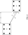
- FIG. 2 illustrates two different vehicles that include features that a sensing apparatus may use to maintain calibration of the sensing apparatus.
- FIG. 2 includes a first vehicle 210 and a second vehicle 240. Each of these vehicles includes several features F that may be identified by a sensing apparatus.
- the first vehicle 210 includes a LiDAR sensor 220 and a camera sensor 230. Line 225 is associated with an angle that the LiDAR sensor senses one of the features F of the second vehicle 240 and line 235 is associated with an angle that the camera sensor senses the same feature F of the second vehicle 240.
- Data from the sensors 220 & 230 may include data associated with several of the features F located at vehicle 240 that are visible to each of the sensors 220 & 230. This can allow a calibration process to evaluate data from several different points of a vehicle in order to more accurately perform a calibration function.
- FIG. 2 does not show relative motion between vehicle 210 and vehicle 240. This is because in certain instances, these vehicles may be moving in a same direction, possibly at a same or similar speed. When the two vehicles are moving in a same direction, vehicle 210 may maintain a same relative position relative to vehicle 240 when the calibration of the sensing apparatus is checked and possibly updated. This process could also include evaluating radar data to identify a distance that the two vehicles are separated during a calibration check or update process.
- FIG. 3 illustrates an example of an AV management system 300.
- AV management system 300 and any system discussed in the present disclosure, there can be additional or fewer components in similar or alternative configurations.
- the illustrations and examples provided in the present disclosure are for conciseness and clarity. Other embodiments may include different numbers and/or types of elements, but one of ordinary skill the art will appreciate that such variations do not depart from the scope of the present disclosure.
- the AV management system 300 includes an AV 302, a data center 350, and a client computing device 370.
- the AV 302, the data center 350, and the client computing device 370 can communicate with one another over one or more networks (not shown), such as a public network (e.g., the Internet, an Infrastructure as a Service (IaaS) network, a Platform as a Service (PaaS) network, a Software as a Service (SaaS) network, other Cloud Service Provider (CSP) network, etc.), a private network (e.g., a Local Area Network (LAN), a private cloud, a Virtual Private Network (VPN), etc.), and/or a hybrid network (e.g., a multi-cloud or hybrid cloud network, etc.).
- a public network e.g., the Internet, an Infrastructure as a Service (IaaS) network, a Platform as a Service (PaaS) network, a Software as a Service (SaaS) network, other
- the AV 302 can navigate roadways without a human driver based on sensor signals generated by multiple sensor systems 304, 306, and 308.
- the sensor systems 304-308 can include different types of sensors and can be arranged about the AV 302.
- the sensor systems 304-308 can comprise Inertial Measurement Units (IMUs), cameras (e.g., still image cameras, video cameras, etc.), light sensors (e.g., LIDAR systems, ambient light sensors, infrared sensors, etc.), RADAR systems, GPS receivers, audio sensors (e.g., microphones, Sound Navigation and Ranging (SONAR) systems, ultrasonic sensors, etc.), engine sensors, speedometers, tachometers, odometers, altimeters, tilt sensors, impact sensors, airbag sensors, seat occupancy sensors, open/closed door sensors, tire pressure sensors, rain sensors, and so forth.
- the sensor system 304 can be a camera system
- the sensor system 306 can be a LIDAR system
- the sensor system 308 can
- the AV 302 can also include several mechanical systems that can be used to maneuver or operate the AV 302.
- the mechanical systems can include a vehicle propulsion system 330, a braking system 332, a steering system 334, a safety system 336, and a cabin system 338, among other systems.
- the vehicle propulsion system 330 can include an electric motor, an internal combustion engine, or both.
- the braking system 332 can include an engine brake, brake pads, actuators, and/or any other suitable componentry configured to assist in decelerating the AV 302.
- the steering system 334 can include suitable componentry configured to control the direction of movement of the AV 302 during navigation.
- the safety system 336 can include lights and signal indicators, a parking brake, airbags, and so forth.
- the cabin system 338 can include cabin temperature control systems, in-cabin entertainment systems, and so forth.
- the AV 302 might not include human driver actuators (e.g., steering wheel, handbrake, foot brake pedal, foot accelerator pedal, turn signal lever, window wipers, etc.) for controlling the AV 302.
- the cabin system 338 can include one or more client interfaces (e.g., Graphical User Interfaces (GUIs), Voice User Interfaces (VUls), etc.) for controlling certain aspects of the mechanical systems 330-338.
- GUIs Graphical User Interfaces
- VUls Voice User Interfaces
- the AV 302 can additionally include a local computing device 310 that is in communication with the sensor systems 304-308, the mechanical systems 330-338, the data center 350, and the client computing device 370, among other systems.
- the local computing device 310 can include one or more processors and memory, including instructions that can be executed by the one or more processors. The instructions can make up one or more software stacks or components responsible for controlling the AV 302; communicating with the data center 350, the client computing device 370, and other systems; receiving inputs from riders, passengers, and other entities within the AV's environment; logging metrics collected by the sensor systems 304-308; and so forth.
- the local computing device 310 includes a perception stack 312, a mapping and localization stack 314, a prediction stack 316, a planning stack 318, a communications stack 320, a control stack 322, an AV operational database 324, and an HD geospatial database 326, among other stacks and systems.
- the perception stack 312 can enable the AV 302 to "see” (e.g., via cameras, LIDAR sensors, infrared sensors, etc.), “hear” (e.g., via microphones, ultrasonic sensors, RADAR, etc.), and “feel” (e.g., pressure sensors, force sensors, impact sensors, etc.) its environment using information from the sensor systems 304-308, the mapping and localization stack 314, the HD geospatial database 326, other components of the AV, and other data sources (e.g., the data center 350, the client computing device 370, third party data sources, etc.).
- the perception stack 312 can detect and classify objects and determine their current locations, speeds, directions, and the like.
- the mapping and localization stack 314 can determine the AV's position and orientation (pose) using different methods from multiple systems (e.g., GPS, IMUs, cameras, LIDAR, RADAR, ultrasonic sensors, the HD geospatial database 322, etc.).
- the AV 302 can compare sensor data captured in real-time by the sensor systems 304-308 to data in the HD geospatial database 326 to determine its precise (e.g., accurate to the order of a few centimeters or less) position and orientation.
- the AV 302 can focus its search based on sensor data from one or more first sensor systems (e.g., GPS) by matching sensor data from one or more second sensor systems (e.g., LIDAR). If the mapping and localization information from one system is unavailable, the AV 302 can use mapping and localization information from a redundant system and/or from remote data sources.
- the planning stack 318 can determine how to maneuver or operate the AV 302 safely and efficiently in its environment.
- the planning stack 316 can receive the location, speed, and direction of the AV 302, geospatial data, data regarding objects sharing the road with the AV 302 (e.g., pedestrians, bicycles, vehicles, ambulances, buses, cable cars, trains, traffic lights, lanes, road markings, etc.) or certain events occurring during a trip (e.g., emergency vehicle blaring a siren, intersections, occluded areas, street closures for construction or street repairs, double-parked cars, etc.), traffic rules and other safety standards or practices for the road, user input, and other relevant data for directing the AV 302 from one point to another and outputs from the perception stack 312, localization stack 314, and prediction stack 316.
- objects sharing the road with the AV 302 e.g., pedestrians, bicycles, vehicles, ambulances, buses, cable cars, trains, traffic lights, lanes, road markings, etc.
- the planning stack 318 can determine multiple sets of one or more mechanical operations that the AV 302 can perform (e.g., go straight at a specified rate of acceleration, including maintaining the same speed or decelerating; turn on the left blinker, decelerate if the AV is above a threshold range for turning, and turn left; turn on the right blinker, accelerate if the AV is stopped or below the threshold range for turning, and turn right; decelerate until completely stopped and reverse; etc.), and select the best one to meet changing road conditions and events. If something unexpected happens, the planning stack 318 can select from multiple backup plans to carry out. For example, while preparing to change lanes to turn right at an intersection, another vehicle may aggressively cut into the destination lane, making the lane change unsafe. The planning stack 318 could have already determined an alternative plan for such an event. Upon its occurrence, it could help direct the AV 302 to go around the block instead of blocking a current lane while waiting for an opening to change lanes.
- the control stack 322 can manage the operation of the vehicle propulsion system 330, the braking system 332, the steering system 334, the safety system 336, and the cabin system 338.
- the control stack 322 can receive sensor signals from the sensor systems 304-308 as well as communicate with other stacks or components of the local computing device 310 or a remote system (e.g., the data center 350) to effectuate operation of the AV 302.
- the control stack 322 can implement the final path or actions from the multiple paths or actions provided by the planning stack 318. This can involve turning the routes and decisions from the planning stack 318 into commands for the actuators that control the AV's steering, throttle, brake, and drive unit.
- the communication stack 320 can also facilitate the local exchange of information, such as through a wired connection (e.g., a user's mobile computing device docked in an in-car docking station or connected via Universal Serial Bus (USB), etc.) or a local wireless connection (e.g., Wireless Local Area Network (WLAN), Bluetooth ® , infrared, etc.).
- a wired connection e.g., a user's mobile computing device docked in an in-car docking station or connected via Universal Serial Bus (USB), etc.
- a local wireless connection e.g., Wireless Local Area Network (WLAN), Bluetooth ® , infrared, etc.
- the HD geospatial database 326 can store HD maps and related data of the streets upon which the AV 302 travels.
- the HD maps and related data can comprise multiple layers, such as an areas layer, a lanes and boundaries layer, an intersections layer, a traffic controls layer, and so forth.
- the areas layer can include geospatial information indicating geographic areas that are drivable (e.g., roads, parking areas, shoulders, etc.) or not drivable (e.g., medians, sidewalks, buildings, etc.), drivable areas that constitute links or connections (e.g., drivable areas that form the same road) versus intersections (e.g., drivable areas where two or more roads intersect), and so on.
- the lanes and boundaries layer can include geospatial information of road lanes (e.g., lane centerline, lane boundaries, type of lane boundaries, etc.) and related attributes (e.g., direction of travel, speed limit, lane type, etc.).
- the lanes and boundaries layer can also include 3D attributes related to lanes (e.g., slope, elevation, curvature, etc.).
- the intersections layer can include geospatial information of intersections (e.g., crosswalks, stop lines, turning lane centerlines and/or boundaries, etc.) and related attributes (e.g., permissive, protected/permissive, or protected only left turn lanes; legal or illegal u-turn lanes; permissive or protected only right turn lanes; etc.).
- the traffic controls lane can include geospatial information of traffic signal lights, traffic signs, and other road objects and related attributes.
- the AV operational database 324 can store raw AV data generated by the sensor systems 304-308, stacks 312 - 322, and other components of the AV 302 and/or data received by the AV 302 from remote systems (e.g., the data center 350, the client computing device 370, etc.).
- the raw AV data can include HD LIDAR point cloud data, image data, RADAR data, GPS data, and other sensor data that the data center 350 can use for creating or updating AV geospatial data or for creating simulations of situations encountered by AV 302 for future testing or training of various machine learning algorithms that are incorporated in the local computing device 310.
- the data center 350 can be a private cloud (e.g., an enterprise network, a co-location provider network, etc.), a public cloud (e.g., an Infrastructure as a Service (IaaS) network, a Platform as a Service (PaaS) network, a Software as a Service (SaaS) network, or other Cloud Service Provider (CSP) network), a hybrid cloud, a multi-cloud, and so forth.
- the data center 350 can include one or more computing devices remote to the local computing device 310 for managing a fleet of AVs and AV-related services.
- the data center 350 may also support a ridesharing service, a delivery service, a remote/roadside assistance service, street services (e.g., street mapping, street patrol, street cleaning, street metering, parking reservation, etc.), and the like.
- a ridesharing service e.g., a delivery service, a remote/roadside assistance service, street services (e.g., street mapping, street patrol, street cleaning, street metering, parking reservation, etc.), and the like.
- street services e.g., street mapping, street patrol, street cleaning, street metering, parking reservation, etc.
- the data center 350 can send and receive various signals to and from the AV 302 and the client computing device 370. These signals can include sensor data captured by the sensor systems 304-308, roadside assistance requests, software updates, ridesharing pick-up and drop-off instructions, and so forth.
- the data center 350 includes a data management platform 352, an Artificial Intelligence/Machine Learning (AI/ML) platform 354, a simulation platform 356, a remote assistance platform 358, and a ridesharing platform 360, among other systems.
- AI/ML Artificial Intelligence/Machine Learning
- the data management platform 352 can be a "big data" system capable of receiving and transmitting data at high velocities (e.g., near real-time or real-time), processing a large variety of data and storing large volumes of data (e.g., terabytes, petabytes, or more of data).
- the varieties of data can include data having different structured (e.g., structured, semi-structured, unstructured, etc.), data of different types (e.g., sensor data, mechanical system data, ridesharing service, map data, audio, video, etc.), data associated with different types of data stores (e.g., relational databases, key-value stores, document databases, graph databases, column-family databases, data analytic stores, search engine databases, time series databases, object stores, file systems, etc.), data originating from different sources (e.g., AVs, enterprise systems, social networks, etc.), data having different rates of change (e.g., batch, streaming, etc.), or data having other heterogeneous characteristics.
- the various platforms and systems of the data center 350 can access data stored by the data management platform 352 to provide their respective services.
- the AI/ML platform 354 can provide the infrastructure for training and evaluating machine learning algorithms for operating the AV 302, the simulation platform 356, the remote assistance platform 358, the ridesharing platform 360, the cartography platform 362, and other platforms and systems.
- data scientists can prepare data sets from the data management platform 352; select, design, and train machine learning models; evaluate, refine, and deploy the models; maintain, monitor, and retrain the models; and so on.
- the simulation platform 356 can enable testing and validation of the algorithms, machine learning models, neural networks, and other development efforts for the AV 302, the remote assistance platform 358, the ridesharing platform 360, the cartography platform 362, and other platforms and systems.
- the simulation platform 356 can replicate a variety of driving environments and/or reproduce real-world scenarios from data captured by the AV 302, including rendering geospatial information and road infrastructure (e.g., streets, lanes, crosswalks, traffic lights, stop signs, etc.) obtained from the cartography platform 362; modeling the behavior of other vehicles, bicycles, pedestrians, and other dynamic elements; simulating inclement weather conditions, different traffic scenarios; and so on.
- geospatial information and road infrastructure e.g., streets, lanes, crosswalks, traffic lights, stop signs, etc.
- the remote assistance platform 358 can generate and transmit instructions regarding the operation of the AV 302. For example, in response to an output of the AI/ML platform 354 or other system of the data center 350, the remote assistance platform 358 can prepare instructions for one or more stacks or other components of the AV 302.
- the ridesharing platform 360 can interact with a customer of a ridesharing service via a ridesharing application 372 executing on the client computing device 370.
- the client computing device 370 can be any type of computing system, including a server, desktop computer, laptop, tablet, smartphone, smart wearable device (e.g., smartwatch, smart eyeglasses or other Head-Mounted Display (HMD), smart ear pods, or other smart in-ear, on-ear, or over-ear device, etc.), gaming system, or other general purpose computing device for accessing the ridesharing application 372.
- the client computing device 370 can be a customer's mobile computing device or a computing device integrated with the AV 302 (e.g., the local computing device 310).
- the ridesharing platform 360 can receive requests to pick up or drop off from the ridesharing application 372 and dispatch the AV 302 for the trip.
- computing system 400 is a distributed system in which the functions described in this disclosure can be distributed within a datacenter, multiple data centers, a peer network, etc.
- one or more of the described system components represents many such components each performing some or all of the function for which the component is described.
- the components can be physical or virtual devices.
- a service can be software that resides in memory of a client device and/or one or more servers of a content management system and perform one or more functions when a processor executes the software associated with the service.
- a service is a program or a collection of programs that carry out a specific function.
- a service can be considered a server.
- the memory can be a non-transitory computer-readable medium.
- Devices implementing methods according to these disclosures can comprise hardware, firmware and/or software, and can take any of a variety of form factors. Typical examples of such form factors include servers, laptops, smartphones, small form factor personal computers, personal digital assistants, and so on.
- the functionality described herein also can be embodied in peripherals or add-in cards. Such functionality can also be implemented on a circuit board among different chips or different processes executing in a single device, by way of further example.
Landscapes
- Engineering & Computer Science (AREA)
- Remote Sensing (AREA)
- Radar, Positioning & Navigation (AREA)
- Physics & Mathematics (AREA)
- General Physics & Mathematics (AREA)
- Computer Networks & Wireless Communication (AREA)
- Automation & Control Theory (AREA)
- Mechanical Engineering (AREA)
- Transportation (AREA)
- Human Computer Interaction (AREA)
- Electromagnetism (AREA)
- Computer Vision & Pattern Recognition (AREA)
- Theoretical Computer Science (AREA)
- Traffic Control Systems (AREA)
Applications Claiming Priority (1)
| Application Number | Priority Date | Filing Date | Title |
|---|---|---|---|
| US17/682,312 US20230271619A1 (en) | 2022-02-28 | 2022-02-28 | Retroflector on autonomous vehicles for automated buddy camera, light detecting and ranging, and radio detection and ranging calibration |
Publications (1)
| Publication Number | Publication Date |
|---|---|
| EP4235211A1 true EP4235211A1 (fr) | 2023-08-30 |
Family
ID=84943154
Family Applications (1)
| Application Number | Title | Priority Date | Filing Date |
|---|---|---|---|
| EP23151302.9A Withdrawn EP4235211A1 (fr) | 2022-02-28 | 2023-01-12 | Rétroflecteur sur des véhicules autonomes pour caméra d'amis automatisée, détection et télémétrie de lumière, et étalonnage de détection et de télémétrie radio |
Country Status (2)
| Country | Link |
|---|---|
| US (1) | US20230271619A1 (fr) |
| EP (1) | EP4235211A1 (fr) |
Citations (2)
| Publication number | Priority date | Publication date | Assignee | Title |
|---|---|---|---|---|
| WO2020203657A1 (fr) * | 2019-04-04 | 2020-10-08 | ソニー株式会社 | Dispositif de traitement d'informations, procédé de traitement d'informations et programme de traitement d'informations |
| US20210221390A1 (en) * | 2020-01-21 | 2021-07-22 | Qualcomm Incorporated | Vehicle sensor calibration from inter-vehicle communication |
-
2022
- 2022-02-28 US US17/682,312 patent/US20230271619A1/en not_active Abandoned
-
2023
- 2023-01-12 EP EP23151302.9A patent/EP4235211A1/fr not_active Withdrawn
Patent Citations (3)
| Publication number | Priority date | Publication date | Assignee | Title |
|---|---|---|---|---|
| WO2020203657A1 (fr) * | 2019-04-04 | 2020-10-08 | ソニー株式会社 | Dispositif de traitement d'informations, procédé de traitement d'informations et programme de traitement d'informations |
| US20220180561A1 (en) * | 2019-04-04 | 2022-06-09 | Sony Group Corporation | Information processing device, information processing method, and information processing program |
| US20210221390A1 (en) * | 2020-01-21 | 2021-07-22 | Qualcomm Incorporated | Vehicle sensor calibration from inter-vehicle communication |
Also Published As
| Publication number | Publication date |
|---|---|
| US20230271619A1 (en) | 2023-08-31 |
Similar Documents
| Publication | Publication Date | Title |
|---|---|---|
| US20230256999A1 (en) | Simulation of imminent crash to minimize damage involving an autonomous vehicle | |
| US20230192077A1 (en) | Adjustment of object trajectory uncertainty by an autonomous vehicle | |
| US20230195830A1 (en) | Calibration metrics for measuring trajectory prediction | |
| EP4209805A1 (fr) | Filtre multivoie radar avec priorité de piste | |
| US12230009B2 (en) | Determining object behavior and trajectories | |
| US12397806B2 (en) | Autonomous vehicle chassis frame estimation by minimizing distortion from CAD model | |
| US20230399008A1 (en) | Multistatic radar point cloud formation using a sensor waveform encoding schema | |
| US11904870B2 (en) | Configuration management system for autonomous vehicle software stack | |
| US20240012106A1 (en) | Multiple sensor calibration in autonomous vehicles performed in an undefined environment | |
| US12270655B2 (en) | Estimating road grade for inertial measurement unit calibration in an unmapped environment | |
| US12386057B2 (en) | Continuous radar calibration check | |
| US12187316B2 (en) | Camera calibration for underexposed cameras using traffic signal targets | |
| US12560696B2 (en) | Radar tracking association with velocity matching by leveraging kinematics priors | |
| US12517241B2 (en) | Radar detector with velocity profiling | |
| US12153121B2 (en) | Unified radar perception architecture | |
| EP4202476A1 (fr) | Hiérarchisation d'anomalies à l'aide d'un radar adaptatif à double mode | |
| US12151691B2 (en) | Filtering perception-related artifacts | |
| US12258008B1 (en) | Object collision path prediction | |
| US12122422B2 (en) | Secondary autonomous vehicle interceptor in difficult map areas to provide additional sensor data | |
| US12481806B2 (en) | Generating simulations based on real-world scenarios | |
| US12091044B2 (en) | Hierarchical mode anchoring | |
| US20230204738A1 (en) | Emulation of a lidar sensor using historical data collected by a lidar having different intrinsic attributes | |
| US20230192144A1 (en) | Uncertainty prediction for a predicted path of an object that avoids infeasible paths | |
| US20230271619A1 (en) | Retroflector on autonomous vehicles for automated buddy camera, light detecting and ranging, and radio detection and ranging calibration | |
| US12087163B2 (en) | Autonomous vehicle fleet acting as a phase array for imaging and tomography |
Legal Events
| Date | Code | Title | Description |
|---|---|---|---|
| PUAI | Public reference made under article 153(3) epc to a published international application that has entered the european phase |
Free format text: ORIGINAL CODE: 0009012 |
|
| STAA | Information on the status of an ep patent application or granted ep patent |
Free format text: STATUS: REQUEST FOR EXAMINATION WAS MADE |
|
| 17P | Request for examination filed |
Effective date: 20230112 |
|
| AK | Designated contracting states |
Kind code of ref document: A1 Designated state(s): AL AT BE BG CH CY CZ DE DK EE ES FI FR GB GR HR HU IE IS IT LI LT LU LV MC ME MK MT NL NO PL PT RO RS SE SI SK SM TR |
|
| 18D | Application deemed to be withdrawn |
Effective date: 20240301 |