EP4287122B1 - Verfahren zur erzeugung eines reliefdarstellungsmodells mittels photogrammetrie - Google Patents
Verfahren zur erzeugung eines reliefdarstellungsmodells mittels photogrammetrie Download PDFInfo
- Publication number
- EP4287122B1 EP4287122B1 EP23176117.2A EP23176117A EP4287122B1 EP 4287122 B1 EP4287122 B1 EP 4287122B1 EP 23176117 A EP23176117 A EP 23176117A EP 4287122 B1 EP4287122 B1 EP 4287122B1
- Authority
- EP
- European Patent Office
- Prior art keywords
- representation model
- relief representation
- stereo images
- pairs
- disparities
- Prior art date
- Legal status (The legal status is an assumption and is not a legal conclusion. Google has not performed a legal analysis and makes no representation as to the accuracy of the status listed.)
- Active
Links
Images


Classifications
-
- G—PHYSICS
- G06—COMPUTING OR CALCULATING; COUNTING
- G06T—IMAGE DATA PROCESSING OR GENERATION, IN GENERAL
- G06T7/00—Image analysis
- G06T7/50—Depth or shape recovery
- G06T7/55—Depth or shape recovery from multiple images
- G06T7/593—Depth or shape recovery from multiple images from stereo images
-
- G—PHYSICS
- G06—COMPUTING OR CALCULATING; COUNTING
- G06T—IMAGE DATA PROCESSING OR GENERATION, IN GENERAL
- G06T17/00—Three-dimensional [3D] modelling for computer graphics
- G06T17/05—Geographic models
-
- G—PHYSICS
- G06—COMPUTING OR CALCULATING; COUNTING
- G06T—IMAGE DATA PROCESSING OR GENERATION, IN GENERAL
- G06T2207/00—Indexing scheme for image analysis or image enhancement
- G06T2207/10—Image acquisition modality
- G06T2207/10016—Video; Image sequence
- G06T2207/10021—Stereoscopic video; Stereoscopic image sequence
-
- G—PHYSICS
- G06—COMPUTING OR CALCULATING; COUNTING
- G06T—IMAGE DATA PROCESSING OR GENERATION, IN GENERAL
- G06T2207/00—Indexing scheme for image analysis or image enhancement
- G06T2207/10—Image acquisition modality
- G06T2207/10032—Satellite or aerial image; Remote sensing
-
- G—PHYSICS
- G06—COMPUTING OR CALCULATING; COUNTING
- G06T—IMAGE DATA PROCESSING OR GENERATION, IN GENERAL
- G06T2210/00—Indexing scheme for image generation or computer graphics
- G06T2210/61—Scene description
Definitions
- the present invention relates to the field of generation of relief representation models by photogrammetry.
- a common relief representation model generation technique is schematically represented in the Fig. 1 .
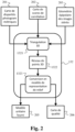
- step 132 of converting the correlation results into unitary relief representation models is carried out, for each of the N pairs of stereo images, using a 3D triangulation step 1321 carried out from a photogrammetric disparity map 201, a correlation score map 202, and an epipolar geometry of the stereo images 203.
- the epipolar geometry of the stereo images 203 provides correspondence information between relief points and epipolar image pixels.
- the photogrammetric disparity map 201, the correlation score map 202, and the epipolar geometry of the stereo images 203 are obtained by executing the correlation calculation step 131 for the pair of stereo images considered.
- the 3D triangulation step 1321 makes it possible to obtain, for the pair of stereo images considered, a 3D point network 1322, which is then converted, in a step 1323, into a relief representation model.
- a unitary relief representation model 205 and a quality map 206 are thus obtained at the output of step 132, for each of the N pairs of stereo images.
- the unitary relief representation models 205, accompanied by their respective quality maps 206, are then merged in order to form the finished relief representation model corresponding to the region of interest ROI or the area of interest AOI.
- a disadvantage of the approach outlined above is the loss of information related to the conversion of unitary correlation results (i.e., per stereo pair) into unitary relief representation models, and the subsequent fusion of these unitary relief representation models to form the finished relief representation model.
- a relief representation model cannot capture all the information present in a correlation result.
- overhanging terrain structures cannot be represented in a digital elevation model, while these overhanging terrain structures can be represented in the correlation result.
- the relief representation model is sampled on a certain grid, which is distinct from the grid on which the correlation calculation; moving from one grid to another involves resampling which necessarily degrades the information.
- a method for generating a relief representation model from a plurality of N pairs of stereo images, each of the N pairs of stereo images being associated with a photogrammetric disparity map which is obtained by correlation calculation from the pair of stereo images in question, the method being characterized in that it comprises the following iterative steps: calculation of geometric disparity maps from a predetermined relief representation model, by projection of the predetermined relief representation model into an epipolar geometry of the pairs of stereo images; calculation of a cost function, representative of a difference between the geometric and photogrammetric disparities, associated with the predetermined relief representation model; and updating the predetermined relief representation model by gradient descent type optimization of the cost function, and reiteration until a predefined stopping criterion is reached.
- FC ⁇ k ⁇ i j W k , 0 i j N m D k i j ⁇ D k , 0 i j
- k is a traversal index of the N pairs of stereo images
- N m is a normalization function
- D k (i,j) is the disparity value for pixel (i,j) in the disparity map geometric associated with the stereo image pair pointed to by the index value k
- D k,0 (i,j) is the disparity value for pixel (i,j) in the photogrammetric disparity map associated with the stereo image pair pointed to by the index value k
- W k,0 (i,j) is the corresponding value for pixel (i,j) in a correlation score map associated, at the end of the correlation calculation, with said photogrammetric disparity map associated with the stereo image pair pointed to by the index value k .
- the relief representation model is a digital elevation model.
- a computer program product comprising instructions for implementing the method according to any of the embodiments presented above, when said instructions are executed by a processor.
- a (non-transitory) information storage medium storing a computer program comprising instructions for implementing the method according to any of the embodiments presented above, when said instructions are read from the information storage medium and executed by a processor.
- a system for generating a relief representation model from a plurality of N pairs of stereo images each of the N pairs of stereo images being associated with a photogrammetric disparity map which is obtained by correlation calculation from the pair of stereo images in question
- the system comprising electronic circuitry configured to implement the following iterative steps: calculation of geometric disparity maps from a predetermined relief representation model, by projection of the predetermined relief representation model into an epipolar geometry of the pairs of stereo images; calculation of a cost function, representative of a difference between the geometric and photogrammetric disparities, associated with the predetermined relief representation model; and updating the predetermined relief representation model by gradient descent type optimization of the cost function, and reiteration until a predefined stopping criterion is reached.
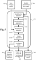
- FIG. 3 schematically illustrates a flowchart of a relief representation model generation algorithm, in one embodiment of the present invention.
- Fig. 3 resumes step 110, in which a computer system obtains a plurality of stereo image pairs of the scene, thus constituting a set of N stereo image pairs 120 covering a region of interest ROI or an area of interest AOI.
- Fig. 3 also resumes, for each of the N pairs of stereo images, step 131 of calculating the correlation between the stereo images of said pair of stereo images.
- step 131 of calculating the correlation between the stereo images of said pair of stereo images.
- a particular embodiment is detailed below in relation to the Fig. 5 .
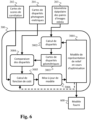
- the algorithm of the Fig. 3 differs from that of the Fig. 1 , as detailed below, in particular in relation to the Fig. 6 .
- the computer system transforms the relief representation model 3001 into a triangular mesh, which defines a continuous and piecewise planar surface.
- Each quadruplet of neighboring pixels is thus divided into four 3D triangles (therefore taking into account the elevation information of said neighboring pixels) around the centroid of said neighboring pixels.
- the geometric disparity calculation is carried out 3D triangle by 3D triangle by the computer system.
- the computer system calculates its projection into the primary epipolar image, then the computer system scans each pixel of the primary epipolar image contained within this 3D triangle.
- the computer system calculates a cost function, representative of a difference between the geometric and photogrammetric disparities, associated with the relief representation model 3001.
- the cost function FC is built around a normalization function N m applied to each point difference resulting from the comparison and summed over all disparity pixels and over all stereo image pairs.
- N m the parameter between the quadratic part and the linear part of the pseudo-Huber norm is chosen equal to one disparity pixel.
- the result of the pseudo-Huber norm is preferentially multiplied point by point for each stereo image pair by the corresponding correlation score value provided in the correlation score maps 202.
- FC ⁇ k ⁇ i j W k , 0 i j N m D k i j ⁇ D k , 0 i j
- FC ⁇ k ⁇ i j W k , 0 i j N m D k i j ⁇ D k , 0 i j
- ⁇ is a weighting factor of the regularization of the relief representation model 3001 in the result of the cost function.
- the weighting factor ⁇ depends on the context of use of the generated relief representation model 3001 and is typically defined by laboratory tests.
- the regulation term R of the relief representation model 3001 is preferably the variant of the total variation, called Huber-TV.
- Other types of regulation can be used when the relief representation model 3001 is a digital model of another type, such as a digital surface model MNS.
- the computer system performs an update of the relief representation model 3001.
- the cost function having a precise analytical definition, the computer system is capable of calculating formal derivatives thereof with respect to the problem variables which are the relief values of the pixels of the relief representation model 3001.
- the update consists of a gradient descent type optimization, such as a conjugate gradient method.
- the stages of the Fig. 6 are repeated until a predefined stopping criterion is reached.
- the stopping criterion is a decrease in cost below a predefined threshold, or reaching a predefined maximum number of iterations, or reaching a predefined maximum execution time of step 300, or upon the occurrence of an external event (for example, upon command from an external control unit).
Landscapes
- Engineering & Computer Science (AREA)
- Physics & Mathematics (AREA)
- Geometry (AREA)
- Software Systems (AREA)
- General Physics & Mathematics (AREA)
- Theoretical Computer Science (AREA)
- Remote Sensing (AREA)
- Computer Graphics (AREA)
- Computer Vision & Pattern Recognition (AREA)
- Image Processing (AREA)
Claims (11)
- Verfahren zur Erzeugung eines Reliefdarstellungsmodells ausgehend von einer Mehrzahl von N Stereobildpaaren (120), wobei jedes der N Stereobildpaare (120) einer Karte mit photogrammetrischen Disparitäten (201) zugeordnet ist, die durch Korrelationsberechnung (1315) ausgehend von dem betreffenden Stereobildpaar (120) erhalten wird, wobei das Verfahren dadurch gekennzeichnet ist, dass es die folgenden iterativen Schritte umfasst:- Berechnen (3002) von Karten mit geometrischen Disparitäten (3003) ausgehend von einem vorbestimmten Reliefdarstellungsmodell (3001) durch Projektion des vorbestimmten Reliefdarstellungsmodells in eine Epipolargeometrie (203) der Stereobildpaare (120);- Berechnen (3005) einer für eine Differenz zwischen den geometrischen und photogrammetrischen Disparitäten repräsentativen Kostenfunktion, die dem vorbestimmten Reliefdarstellungsmodell (3001) zugeordnet ist; und- Aktualisieren (3006) des vorbestimmten Reliefdarstellungsmodells (3001) durch Optimierung vom Typ Gradientenabstieg der Kostenfunktion und Wiederholung bis zum Erreichen eines vorgegebenen Stoppkriteriums.
- Verfahren nach Anspruch 1, wobei die Kostenfunktion FC folgendermaßen ausgedrückt wird:

- Verfahren nach Anspruch 2, wobei die Normalisierungsfunktion Nm die folgendermaßen angewandte Pseudo-Huber-Norm ist:

- Verfahren nach Anspruch 2 oder 3, wobei die Kostenfunktion FC mit einem Term R zur Regularisierung des Reliefdarstellungsmodells angepasst wird, so dass:

- Verfahren nach Anspruch 4, wobei der Term R zur Regularisierung des Reliefdarstellungsmodells (3001) die Gesamtvariation des Reliefdarstellungsmodells (3001) oder seine Huber-TV-Variante ist, die durch ein Rastermaß des Reliefdarstellungsmodells (3001) normalisiert wird.
- Verfahren nach einem der Ansprüche 1 bis 5, wobei die Projektion des vorbestimmten Reliefdarstellungsmodells (3001) in die Epipolargeometrie (203) der Stereobildpaare (120), hier anfängliche Epipolargeometrie genannt, in einer aufwärts abgetasteten Epipolargeometrie durchgeführt wird und das Ergebnis der Projektion anschließend in der anfänglichen Epipolargeometrie abwärts abgetastet wird.
- Verfahren nach Anspruch 6, wobei das Ergebnis der Projektion in der anfänglichen Epipolargeometrie mithilfe eines bilinearen Konvolutionskerns abwärts abgetastet wird, wobei eine Tiefpassfilterung ausgeführt wird.
- Verfahren nach einem der Ansprüche 1 bis 7, wobei das Reliefdarstellungsmodell (3001) ein digitales Höhenmodell ist.
- Computerprogrammprodukt, das Anweisungen umfasst, die bei der Ausführung der Anweisungen durch einen Prozessor das Verfahren nach einem der Ansprüche 1 bis 8 implementieren.
- Informationsspeichermedium, das ein Computerprogramm speichert, das Anweisungen umfasst, die beim Lesen der Anweisungen von dem Informationsspeichermedium und Ausführen durch einen Prozessor das Verfahren nach einem der Ansprüche 1 bis 8 implementieren.
- System zur Erzeugung eines Reliefdarstellungsmodells ausgehend von einer Mehrzahl von N Stereobildpaaren (120), wobei jedes der N Stereobildpaare (120) einer Karte mit photogrammetrischen Disparitäten (201) zugeordnet ist, die durch Korrelationsberechnung (1315) ausgehend von dem betreffenden Stereobildpaar (120) erhalten wird, wobei das System eine elektronische Schaltungsanordnung umfasst, die dazu ausgestaltet ist, die folgenden iterativen Schritte zu implementieren:- Berechnen (3002) von Karten mit geometrischen Disparitäten (3003) ausgehend von einem vorbestimmten Reliefdarstellungsmodell (3001) durch Projektion des vorbestimmten Reliefdarstellungsmodells (3001) in eine Epipolargeometrie (203) der Stereobildpaare (120);- Berechnen (3005) einer für eine Differenz zwischen den geometrischen und photogrammetrischen Disparitäten repräsentativen Kostenfunktion, die dem vorbestimmten Reliefdarstellungsmodell (3001) zugeordnet ist; und- Aktualisieren (3006) des vorbestimmten Reliefdarstellungsmodells (3001) durch Optimierung vom Typ Gradientenabstieg der Kostenfunktion und Wiederholung bis zum Erreichen eines vorgegebenen Stoppkriteriums.
Applications Claiming Priority (1)
| Application Number | Priority Date | Filing Date | Title |
|---|---|---|---|
| FR2205303A FR3136303B1 (fr) | 2022-06-02 | 2022-06-02 | Procede de generation de modele de representation de relief par photogrammetrie |
Publications (3)
| Publication Number | Publication Date |
|---|---|
| EP4287122A1 EP4287122A1 (de) | 2023-12-06 |
| EP4287122B1 true EP4287122B1 (de) | 2025-07-02 |
| EP4287122C0 EP4287122C0 (de) | 2025-07-02 |
Family
ID=83690024
Family Applications (1)
| Application Number | Title | Priority Date | Filing Date |
|---|---|---|---|
| EP23176117.2A Active EP4287122B1 (de) | 2022-06-02 | 2023-05-30 | Verfahren zur erzeugung eines reliefdarstellungsmodells mittels photogrammetrie |
Country Status (3)
| Country | Link |
|---|---|
| US (1) | US12541922B2 (de) |
| EP (1) | EP4287122B1 (de) |
| FR (1) | FR3136303B1 (de) |
Family Cites Families (3)
| Publication number | Priority date | Publication date | Assignee | Title |
|---|---|---|---|---|
| EP3545444A4 (de) * | 2016-11-30 | 2020-09-30 | Fited, Inc. | 3d-modellierungssysteme und verfahren |
| US10839543B2 (en) * | 2019-02-26 | 2020-11-17 | Baidu Usa Llc | Systems and methods for depth estimation using convolutional spatial propagation networks |
| US11879732B2 (en) * | 2019-04-05 | 2024-01-23 | Ikegps Group Limited | Methods of measuring structures |
-
2022
- 2022-06-02 FR FR2205303A patent/FR3136303B1/fr active Active
-
2023
- 2023-05-30 EP EP23176117.2A patent/EP4287122B1/de active Active
- 2023-05-31 US US18/326,559 patent/US12541922B2/en active Active
Also Published As
| Publication number | Publication date |
|---|---|
| FR3136303B1 (fr) | 2024-05-17 |
| US12541922B2 (en) | 2026-02-03 |
| US20230394760A1 (en) | 2023-12-07 |
| EP4287122C0 (de) | 2025-07-02 |
| FR3136303A1 (fr) | 2023-12-08 |
| EP4287122A1 (de) | 2023-12-06 |
Similar Documents
| Publication | Publication Date | Title |
|---|---|---|
| Remondino et al. | State of the art in high density image matching | |
| EP2724203B1 (de) | Erzeugung von kartendaten | |
| Bailer et al. | Scale robust multi view stereo | |
| EP3018632B1 (de) | Automatisierte texturierungsabbildung und animation aus bildern | |
| EP2333481B1 (de) | Optronisches System und Verfahren zur Herstellung dreidimensionaler Bilder zur Identifikation | |
| FR3084951A1 (fr) | Procede et systeme de tranformation de cartes normales en cartes de hauteurs | |
| EP3679517B1 (de) | Verfahren zur bestimmung von vorstehenden kanten eines ziels auf einem bild | |
| US11032534B1 (en) | Planar deviation based image reprojection | |
| US20140211286A1 (en) | Apparatus and method for generating digital hologram | |
| EP0731960B1 (de) | Synthetisches bilderzeugungsverfahren mit sphärischem puffer | |
| FR2999325A1 (fr) | Procede iteratif de determination d'une image en deux dimensions ou trois dimensions a partir de signaux issus de tomographie par rayons x | |
| EP3326147A1 (de) | Verfahren und vorrichtung zur darstellung einer dreidimensionalen szene auf einer anzeigefläche mit einer willkürlichen unebenen form | |
| Wei et al. | Joint bilateral propagation upsampling for unstructured multi-view stereo | |
| Gao et al. | Gaussian Building Mesh (GBM): Extract a Building’s 3D Mesh with Google Earth and Gaussian Splatting | |
| EP4287122B1 (de) | Verfahren zur erzeugung eines reliefdarstellungsmodells mittels photogrammetrie | |
| US20210400217A1 (en) | Time-of-flight down-up sampling using a compressed guide | |
| EP3814850B1 (de) | Verfahren zur erzeugung eines digitalen hologramms, zugehörige vorrichtung, holographisches anzeigesystem und computerprogramm | |
| Sun et al. | Adaptive pixelwise inference multi-view stereo | |
| Sabater et al. | Review of low-baseline stereo algorithms and benchmarks | |
| Imperatore et al. | Contribution of super resolution to 3D reconstruction from pairs of satellite images | |
| FR2994500A1 (fr) | Procede d'optimisation de l'execution d'un pipeline graphique | |
| Chapell et al. | NeRF-based 3D reconstruction and orthographic novel view synthesis experiments using City-scale aerial images | |
| WO2009101327A2 (fr) | Procede et dispositif de simulation de contact par images a plan de profondeur | |
| Cao et al. | Orienting raw point sets by global contraction and visibility voting | |
| Leupolz et al. | Impact of tessellation surface model generation process on acoustical tire features |
Legal Events
| Date | Code | Title | Description |
|---|---|---|---|
| PUAI | Public reference made under article 153(3) epc to a published international application that has entered the european phase |
Free format text: ORIGINAL CODE: 0009012 |
|
| STAA | Information on the status of an ep patent application or granted ep patent |
Free format text: STATUS: THE APPLICATION HAS BEEN PUBLISHED |
|
| AK | Designated contracting states |
Kind code of ref document: A1 Designated state(s): AL AT BE BG CH CY CZ DE DK EE ES FI FR GB GR HR HU IE IS IT LI LT LU LV MC ME MK MT NL NO PL PT RO RS SE SI SK SM TR |
|
| STAA | Information on the status of an ep patent application or granted ep patent |
Free format text: STATUS: REQUEST FOR EXAMINATION WAS MADE |
|
| 17P | Request for examination filed |
Effective date: 20240605 |
|
| RBV | Designated contracting states (corrected) |
Designated state(s): AL AT BE BG CH CY CZ DE DK EE ES FI FR GB GR HR HU IE IS IT LI LT LU LV MC ME MK MT NL NO PL PT RO RS SE SI SK SM TR |
|
| GRAP | Despatch of communication of intention to grant a patent |
Free format text: ORIGINAL CODE: EPIDOSNIGR1 |
|
| STAA | Information on the status of an ep patent application or granted ep patent |
Free format text: STATUS: GRANT OF PATENT IS INTENDED |
|
| INTG | Intention to grant announced |
Effective date: 20250130 |
|
| GRAS | Grant fee paid |
Free format text: ORIGINAL CODE: EPIDOSNIGR3 |
|
| GRAA | (expected) grant |
Free format text: ORIGINAL CODE: 0009210 |
|
| STAA | Information on the status of an ep patent application or granted ep patent |
Free format text: STATUS: THE PATENT HAS BEEN GRANTED |
|
| AK | Designated contracting states |
Kind code of ref document: B1 Designated state(s): AL AT BE BG CH CY CZ DE DK EE ES FI FR GB GR HR HU IE IS IT LI LT LU LV MC ME MK MT NL NO PL PT RO RS SE SI SK SM TR |
|
| REG | Reference to a national code |
Ref country code: GB Ref legal event code: FG4D Free format text: NOT ENGLISH |
|
| REG | Reference to a national code |
Ref country code: CH Ref legal event code: EP |
|
| REG | Reference to a national code |
Ref country code: DE Ref legal event code: R096 Ref document number: 602023004450 Country of ref document: DE |
|
| REG | Reference to a national code |
Ref country code: IE Ref legal event code: FG4D Free format text: LANGUAGE OF EP DOCUMENT: FRENCH |
|
| U01 | Request for unitary effect filed |
Effective date: 20250722 |
|
| U07 | Unitary effect registered |
Designated state(s): AT BE BG DE DK EE FI FR IT LT LU LV MT NL PT RO SE SI Effective date: 20250729 |
|
| PG25 | Lapsed in a contracting state [announced via postgrant information from national office to epo] |
Ref country code: IS Free format text: LAPSE BECAUSE OF FAILURE TO SUBMIT A TRANSLATION OF THE DESCRIPTION OR TO PAY THE FEE WITHIN THE PRESCRIBED TIME-LIMIT Effective date: 20251102 |
|
| PG25 | Lapsed in a contracting state [announced via postgrant information from national office to epo] |
Ref country code: NO Free format text: LAPSE BECAUSE OF FAILURE TO SUBMIT A TRANSLATION OF THE DESCRIPTION OR TO PAY THE FEE WITHIN THE PRESCRIBED TIME-LIMIT Effective date: 20251002 |
|
| PG25 | Lapsed in a contracting state [announced via postgrant information from national office to epo] |
Ref country code: HR Free format text: LAPSE BECAUSE OF FAILURE TO SUBMIT A TRANSLATION OF THE DESCRIPTION OR TO PAY THE FEE WITHIN THE PRESCRIBED TIME-LIMIT Effective date: 20250702 |
|
| PG25 | Lapsed in a contracting state [announced via postgrant information from national office to epo] |
Ref country code: GR Free format text: LAPSE BECAUSE OF FAILURE TO SUBMIT A TRANSLATION OF THE DESCRIPTION OR TO PAY THE FEE WITHIN THE PRESCRIBED TIME-LIMIT Effective date: 20251003 |
|
| PG25 | Lapsed in a contracting state [announced via postgrant information from national office to epo] |
Ref country code: CZ Free format text: LAPSE BECAUSE OF FAILURE TO SUBMIT A TRANSLATION OF THE DESCRIPTION OR TO PAY THE FEE WITHIN THE PRESCRIBED TIME-LIMIT Effective date: 20250702 |
|
| PG25 | Lapsed in a contracting state [announced via postgrant information from national office to epo] |
Ref country code: PL Free format text: LAPSE BECAUSE OF FAILURE TO SUBMIT A TRANSLATION OF THE DESCRIPTION OR TO PAY THE FEE WITHIN THE PRESCRIBED TIME-LIMIT Effective date: 20250702 |
|
| PG25 | Lapsed in a contracting state [announced via postgrant information from national office to epo] |
Ref country code: RS Free format text: LAPSE BECAUSE OF FAILURE TO SUBMIT A TRANSLATION OF THE DESCRIPTION OR TO PAY THE FEE WITHIN THE PRESCRIBED TIME-LIMIT Effective date: 20251002 |
|
| PG25 | Lapsed in a contracting state [announced via postgrant information from national office to epo] |
Ref country code: ES Free format text: LAPSE BECAUSE OF FAILURE TO SUBMIT A TRANSLATION OF THE DESCRIPTION OR TO PAY THE FEE WITHIN THE PRESCRIBED TIME-LIMIT Effective date: 20250702 |
|
| PG25 | Lapsed in a contracting state [announced via postgrant information from national office to epo] |
Ref country code: SM Free format text: LAPSE BECAUSE OF FAILURE TO SUBMIT A TRANSLATION OF THE DESCRIPTION OR TO PAY THE FEE WITHIN THE PRESCRIBED TIME-LIMIT Effective date: 20250702 |
|
| PG25 | Lapsed in a contracting state [announced via postgrant information from national office to epo] |
Ref country code: SK Free format text: LAPSE BECAUSE OF FAILURE TO SUBMIT A TRANSLATION OF THE DESCRIPTION OR TO PAY THE FEE WITHIN THE PRESCRIBED TIME-LIMIT Effective date: 20250702 |