EP4307247A1 - Procédé permettant de générer des cartes de couverture du sol - Google Patents
Procédé permettant de générer des cartes de couverture du sol Download PDFInfo
- Publication number
- EP4307247A1 EP4307247A1 EP22185206.4A EP22185206A EP4307247A1 EP 4307247 A1 EP4307247 A1 EP 4307247A1 EP 22185206 A EP22185206 A EP 22185206A EP 4307247 A1 EP4307247 A1 EP 4307247A1
- Authority
- EP
- European Patent Office
- Prior art keywords
- land
- cover
- image
- mesh
- probability values
- Prior art date
- Legal status (The legal status is an assumption and is not a legal conclusion. Google has not performed a legal analysis and makes no representation as to the accuracy of the status listed.)
- Pending
Links
Images



Classifications
-
- G—PHYSICS
- G06—COMPUTING OR CALCULATING; COUNTING
- G06V—IMAGE OR VIDEO RECOGNITION OR UNDERSTANDING
- G06V20/00—Scenes; Scene-specific elements
- G06V20/10—Terrestrial scenes
- G06V20/13—Satellite images
-
- G—PHYSICS
- G06—COMPUTING OR CALCULATING; COUNTING
- G06T—IMAGE DATA PROCESSING OR GENERATION, IN GENERAL
- G06T17/00—Three-dimensional [3D] modelling for computer graphics
- G06T17/05—Geographic models
-
- G—PHYSICS
- G06—COMPUTING OR CALCULATING; COUNTING
- G06T—IMAGE DATA PROCESSING OR GENERATION, IN GENERAL
- G06T17/00—Three-dimensional [3D] modelling for computer graphics
- G06T17/20—Finite element generation, e.g. wire-frame surface description, tesselation
-
- G—PHYSICS
- G06—COMPUTING OR CALCULATING; COUNTING
- G06T—IMAGE DATA PROCESSING OR GENERATION, IN GENERAL
- G06T7/00—Image analysis
- G06T7/10—Segmentation; Edge detection
- G06T7/11—Region-based segmentation
-
- G—PHYSICS
- G06—COMPUTING OR CALCULATING; COUNTING
- G06T—IMAGE DATA PROCESSING OR GENERATION, IN GENERAL
- G06T7/00—Image analysis
- G06T7/50—Depth or shape recovery
-
- G—PHYSICS
- G06—COMPUTING OR CALCULATING; COUNTING
- G06V—IMAGE OR VIDEO RECOGNITION OR UNDERSTANDING
- G06V10/00—Arrangements for image or video recognition or understanding
- G06V10/20—Image preprocessing
- G06V10/26—Segmentation of patterns in the image field; Cutting or merging of image elements to establish the pattern region, e.g. clustering-based techniques; Detection of occlusion
-
- G—PHYSICS
- G06—COMPUTING OR CALCULATING; COUNTING
- G06V—IMAGE OR VIDEO RECOGNITION OR UNDERSTANDING
- G06V10/00—Arrangements for image or video recognition or understanding
- G06V10/70—Arrangements for image or video recognition or understanding using pattern recognition or machine learning
- G06V10/764—Arrangements for image or video recognition or understanding using pattern recognition or machine learning using classification, e.g. of video objects
-
- G—PHYSICS
- G06—COMPUTING OR CALCULATING; COUNTING
- G06V—IMAGE OR VIDEO RECOGNITION OR UNDERSTANDING
- G06V10/00—Arrangements for image or video recognition or understanding
- G06V10/70—Arrangements for image or video recognition or understanding using pattern recognition or machine learning
- G06V10/77—Processing image or video features in feature spaces; using data integration or data reduction, e.g. principal component analysis [PCA] or independent component analysis [ICA] or self-organising maps [SOM]; Blind source separation
- G06V10/80—Fusion, i.e. combining data from various sources at the sensor level, preprocessing level, feature extraction level or classification level
- G06V10/809—Fusion, i.e. combining data from various sources at the sensor level, preprocessing level, feature extraction level or classification level of classification results, e.g. where the classifiers operate on the same input data
-
- G—PHYSICS
- G06—COMPUTING OR CALCULATING; COUNTING
- G06V—IMAGE OR VIDEO RECOGNITION OR UNDERSTANDING
- G06V10/00—Arrangements for image or video recognition or understanding
- G06V10/70—Arrangements for image or video recognition or understanding using pattern recognition or machine learning
- G06V10/82—Arrangements for image or video recognition or understanding using pattern recognition or machine learning using neural networks
-
- G—PHYSICS
- G06—COMPUTING OR CALCULATING; COUNTING
- G06V—IMAGE OR VIDEO RECOGNITION OR UNDERSTANDING
- G06V20/00—Scenes; Scene-specific elements
- G06V20/10—Terrestrial scenes
- G06V20/17—Terrestrial scenes taken from planes or by drones
-
- G—PHYSICS
- G06—COMPUTING OR CALCULATING; COUNTING
- G06V—IMAGE OR VIDEO RECOGNITION OR UNDERSTANDING
- G06V20/00—Scenes; Scene-specific elements
- G06V20/10—Terrestrial scenes
- G06V20/176—Urban or other man-made structures
-
- G—PHYSICS
- G06—COMPUTING OR CALCULATING; COUNTING
- G06V—IMAGE OR VIDEO RECOGNITION OR UNDERSTANDING
- G06V20/00—Scenes; Scene-specific elements
- G06V20/50—Context or environment of the image
- G06V20/56—Context or environment of the image exterior to a vehicle by using sensors mounted on the vehicle
-
- G—PHYSICS
- G06—COMPUTING OR CALCULATING; COUNTING
- G06V—IMAGE OR VIDEO RECOGNITION OR UNDERSTANDING
- G06V20/00—Scenes; Scene-specific elements
- G06V20/60—Type of objects
- G06V20/64—Three-dimensional [3D] objects
- G06V20/647—Three-dimensional [3D] objects by matching two-dimensional images to three-dimensional objects
-
- G—PHYSICS
- G06—COMPUTING OR CALCULATING; COUNTING
- G06V—IMAGE OR VIDEO RECOGNITION OR UNDERSTANDING
- G06V20/00—Scenes; Scene-specific elements
- G06V20/70—Labelling scene content, e.g. deriving syntactic or semantic representations
-
- G—PHYSICS
- G06—COMPUTING OR CALCULATING; COUNTING
- G06N—COMPUTING ARRANGEMENTS BASED ON SPECIFIC COMPUTATIONAL MODELS
- G06N3/00—Computing arrangements based on biological models
- G06N3/02—Neural networks
- G06N3/04—Architecture, e.g. interconnection topology
-
- G—PHYSICS
- G06—COMPUTING OR CALCULATING; COUNTING
- G06N—COMPUTING ARRANGEMENTS BASED ON SPECIFIC COMPUTATIONAL MODELS
- G06N3/00—Computing arrangements based on biological models
- G06N3/02—Neural networks
- G06N3/08—Learning methods
-
- G—PHYSICS
- G06—COMPUTING OR CALCULATING; COUNTING
- G06T—IMAGE DATA PROCESSING OR GENERATION, IN GENERAL
- G06T2200/00—Indexing scheme for image data processing or generation, in general
- G06T2200/08—Indexing scheme for image data processing or generation, in general involving all processing steps from image acquisition to 3D model generation
-
- G—PHYSICS
- G06—COMPUTING OR CALCULATING; COUNTING
- G06T—IMAGE DATA PROCESSING OR GENERATION, IN GENERAL
- G06T2207/00—Indexing scheme for image analysis or image enhancement
- G06T2207/10—Image acquisition modality
- G06T2207/10028—Range image; Depth image; 3D point clouds
-
- G—PHYSICS
- G06—COMPUTING OR CALCULATING; COUNTING
- G06T—IMAGE DATA PROCESSING OR GENERATION, IN GENERAL
- G06T2207/00—Indexing scheme for image analysis or image enhancement
- G06T2207/10—Image acquisition modality
- G06T2207/10032—Satellite or aerial image; Remote sensing
-
- G—PHYSICS
- G06—COMPUTING OR CALCULATING; COUNTING
- G06T—IMAGE DATA PROCESSING OR GENERATION, IN GENERAL
- G06T2207/00—Indexing scheme for image analysis or image enhancement
- G06T2207/20—Special algorithmic details
- G06T2207/20084—Artificial neural networks [ANN]
Definitions
- the present invention pertains to a computer-implemented method for automatically generating maps comprising land-cover information of an area based on a plurality of input images.
- a texture comprising the generated land-cover information is generated and used for texturing a three-dimensional mesh or an orthoimage of the area for providing the land-cover information, e.g. as a two-dimensional land-cover map, to a user.
- the land-cover information is created based on a plurality of input images and using artificial intelligence (AI).
- AI artificial intelligence
- the land-cover information of some parts of the area may not be determined with sufficient certainty.
- some areas may be occluded in the single view, e.g. because of objects blocking the view between a satellite or aerial camera and the ground (e.g. vegetation such as trees, mobile objects such as vehicles, or roofing such as covered walkways). In this case the land-cover information related to the ground at these areas cannot be determined directly but has to be guessed, e.g. based on the visible surrounding areas.
- a first aspect of the invention pertains to a computer-implemented method for generating one or more land-cover maps of an area.
- the method comprises the following steps that are executed in a computer system:
- the method further comprises:
- the method comprises
- a plurality of different land-cover maps are generated for the same area, and the method comprises receiving a user input that comprises a selection of one of the plurality of generated land-cover maps to be displayed, and displaying the selected land-cover map on the screen.
- a user input that comprises a selection of one of the plurality of generated land-cover maps to be displayed
- displaying the selected land-cover map on the screen
- indicators of selectable land-cover maps of the plurality of land-cover maps are displayed and the user input comprises selecting one of the selectable land-cover maps.
- the one or more land-cover maps comprise at least a combined land-cover map showing the most probable land-cover class for every pixel of the map.
- the one or more land-cover maps comprise at least one or more per-class land-cover maps showing the probability of one land-cover class for every pixel of the map.
- the one or more land-cover maps comprise at least one 2D land-cover map that is generated based on the 3D mesh.
- the 2D land-cover map may be generated by rasterization of the 3D mesh to an orthographic view.
- a ray is created for each pixel of said 2D land-cover map, which ray runs in vertical direction from the respective pixel through the 3D mesh, the ray crossing a surface of the 3D mesh at one or more crossing points.
- the area comprises 3D objects including buildings, vehicles and/or trees.
- the at least one 2D land-cover map may comprise:
- the one or more land-cover maps comprise at least one 3D model of the area, which 3D model is generated based on the 3D mesh.
- the 3D model is a classified mesh or point cloud, and/or shows the most probable land-cover class.
- the method comprises receiving an orthoimage of the area.
- the pixels of the land-cover map may correspond to at least a subset of the pixels of the orthoimage.
- the plurality of cameras is selected based on the orthoimage.
- the plurality of input images comprise
- the method comprises receiving depth information and using the depth information for generating the 3D mesh.
- the cameras may be embodied as a stereo camera or as a range-imaging camera and configured to provide said depth information.
- the semantic segmentation in the input images is performed using artificial intelligence (AI) and a trained neural network, e.g. using a machine-learning, deep-learning or feature-learning algorithm.
- AI artificial intelligence
- the set of land-cover classes comprises at least ten land-cover classes, more particularly at least twenty land-cover classes.
- the weighting comprises weighting probabilities of a set of single-image probability values the higher, the more acute the angle of an image axis of the input image of the respective set of single-image probability values is relative to the 3D mesh at a surface point of the 3D mesh onto which the set of single-image probability values is projected.
- the weighting may comprise using the cosine of the angle.
- the weighting comprises assigning a confidence value to each set of single-image probability values.
- the weighted set of single-image probability values may be calculated by multiplying the respective set of single-image probability values and the confidence value.
- a second aspect of the invention pertains to a computer system comprising a processing unit and a data storage unit, wherein the data storage unit is configured to receive and store input data, e.g. comprising input-image data, to store one or more algorithms, and to store and provide output data.
- the algorithms comprise at least an SfM algorithm and optionally also a machine-learning, deep-learning or feature-learning algorithm.
- the processing unit is configured to generate, based on the input data and using the algorithms, at least one land-cover map of an area as output data by performing the method according to the first aspect of the invention.
- a third aspect of the invention pertains to a computer programme product comprising programme code which is stored on a machine-readable medium, or being embodied by an electromagnetic wave comprising a programme code segment, and having computer-executable instructions for performing, particularly when executed on a processing unit of a computer system according to the second aspect of the invention, the method according to the first aspect.
- Figure 1 shows an orthoimage 10 of an urban area.
- the orthoimage may have been produced based on images captured by means of satellite imaging or aerial photography.
- the imaged area comprises several buildings, roads, vehicles and vegetation.
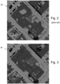
- Figures 2 and 3 each shows a land-cover map 20, 20' of the area imaged in the orthoimage 10 of Figure 1 .
- land-cover information may be added to the orthoimage to generate the map 20, 20'.
- the land-cover information is generated by determining for each pixel of the orthoimage 10 the most probable land cover using artificial intelligence (AI).
- AI artificial intelligence
- the map 20' depicted in Figure 2 is based on only a single view, i.e. that of the orthoimage 10 itself, so that the land-cover information of some parts of the area has not been determined correctly. For instance, relying only on orthoimages AI often misclassifies flat roofs or roof terraces as ground.
- Figure 3 shows another land-cover map 20 of the area depicted in the orthoimage 10 of Figure 1 , wherein - according to the present invention - the map 20 comprises land-cover information that is generated not only from the orthoimage but from a multitude of input images captured by a multitude of cameras from different angles and positions. In each of these images for each pixel the probabilities of all land cover classes are determined using AI. In the shown example, the produced land-cover map 20 is a combined land-cover map showing the most probable land-cover class for each pixel of the map.
- Figure 4 shows an exemplary camera distribution for capturing images of an area 1 as a source for generating the land-cover information of the area to generate land-cover maps like the map 20 of Figure 3 .
- the area comprises 3D objects such as buildings 71, vehicles 72 and trees 73.
- a single orthoimage can only produce a 2D representation of the 3D objects.
- a plurality of input images is used.
- the cameras in Figure 4 comprise a number of aerial cameras 31, 32 which capture digital images of the area 1 with an aerial view, i.e. nadir or oblique images - optionally comprising orthoimages.
- These cameras 31, 32 may be mounted on satellites, airplanes or unmanned aerial vehicles (UAV).
- the aerial cameras 31, 32 may capture several different aerial images 11, 12 of the same area 1 or of different parts of the same area 1 from different positions.
- the cameras further comprise a number of additional (i.e. non-aerial) cameras 33-35 which capture additional digital images 13-15 of parts of the area 1 from different positions.
- Some of these cameras may be fixedly installed in the area 1, e.g. installed on buildings 71 as surveillance cameras or for surveying traffic, others may be installed on ground vehicles 72 moving through the area 1.
- the positions and orientations of the cameras 31-35 while capturing the images 11-15 is known, e.g. with respect to a common coordinate system.
- the relative positions and orientations need to be deduced from the captured images, e.g. using image overlaps and image-recognition approaches.
- the input images can be captured at various locations, with different camera systems, under possibly different lightning conditions and can span a range of resolutions.
- the ground sample distance (GSD) in each image may vary between 2 and 15 cm.
- the cameras 31-35 are calibrated, which allows easy transition between world points (points in real world) and pixels in individual images capturing the respective world point.
- At least a subset of the cameras 31-35 is embodied as stereo cameras or range-imaging cameras providing depth information and/or allowing feature or topography extraction. Also, data from one or more LIDAR devices or 3D laser scanners (not shown here) may be used for providing depth or range information.
- This approach using a plurality of input images, allows more robust predictions compared to predictions based on single-view orthoimages and may be divided into two main stages.
- the input images 11-15 are segmented into several semantic classes, i.e. pre-defined land-cover classes.
- This stage may be run on every input image 11-15 separately and includes determining probabilities of the land-cover classes for each pixel of each input image 11-15.
- the segmentation may be based on publicly available neural networks trained on data processed by a computer vision pipeline. This includes using a training dataset and various data augmentation techniques during the training to ensure generality of the model.
- publicly available up-to-date neural network architectures may be used. Suitable network architectures comprise, e.g., "Deeplab v3+" or "Hierarchical Multi-Scale Attention".
- the second stage is based on structure-from-motion (SfM) approaches combining the segmented images to generate a single 3D model (e.g. a mesh or point cloud).
- generating the 3D model additionally comprises using depth or range information that is captured using 3D scanners (e.g. LIDAR), stereo cameras and/or range-imaging cameras.
- the individually segmented images - together with the probabilities determined during semantic segmentation for each image - are then projected onto the 3D model, e.g. onto vertices of the 3D mesh created by SfM algorithms.
- the projected probabilities are weighted by the angle of impact to the mesh and averaged.
- Weighting the probabilities adds a confidence factor that is based on the respective angle of the image axis relative to the surface of the 3D mesh (or other 3D model) onto which the image pixel is projected. For instance, the probabilities of a certain image pixel may be weighted the higher the more acute the impact angle of the respective image axis is relative to the mesh at that surface point of the mesh onto which said image pixel is projected. In some embodiments, this weighting comprises using the cosine of the angle. Since each impact angle is between 0° and 90°, the respective cosine values are between 1 and 0, wherein a value of 1 means the highest weighting and a value of 0 means the lowest weighting. Thus, acute angles having high cosine values are weighted higher, whereas right angles are given the lowest weight.
- the land-cover predictions are not limited to 2D space only. This can be beneficial, for example in extraction of trees and buildings, i.e. to determine the land cover below roofs or vegetation.
- Figure 5 shows a classified mesh 24 which can be generated directly from the 3D mesh and may be displayed as a 3D land-cover map on a screen to a user. Additionally or alternatively, the 3D mesh or the classified mesh 24 can be rasterized from ortho view to generate a two-dimensional (2D) raster output, e.g. the 2D land-cover map 20 of Figure 3 .
- 2D two-dimensional
- the approach according to the invention allows generating and presenting to a user for instance:
- the combined land-cover maps 20 and the per-class land-cover maps 21-23 may be displayed as 2D maps, whereas the classified point clouds or meshes 24 may be displayed as 3D maps.
- the 2D maps may either respect the occlusions by the 3D mesh from orthographic view ("vision related"), or ignore the occlusions by the 3D mesh, thus allowing to see under trees and overhangs of buildings ("ground related”), optionally showing the highest probability through all mesh layers without occlusions from orthographic view.
- a ray For each pixel of a 2D map, a ray is created that runs in vertical direction from the respective pixel through the mesh 25. This ray thus crosses the mesh 25 at one or more points.
- a vision-related (e.g. top-view) map For a vision-related (e.g. top-view) map, only the highest of those crossing points is used and the most probable class is chosen from the averaged probabilities. For a ground-related map, only the lowest of those crossing points is used and the most probable class is chosen from the averaged probabilities.
- the highest probability in every pixel for every land-cover class is required separately.
- the maximum probability of a given class in the crossing points may be used.
- non-rigid objects such as moving cars can be identified in the scene. This information can be used to remove moving objects that cause visually unpleasing effects from the texturing. This removing of moving vehicles from a texture is disclosed in the applicant's earlier application with the application number EP21204032.3 . Similarly to removing the moving objects from the texture, they may also be ignored in land-cover information, instead showing the land-cover information of the ground beneath the moving objects.
- Figures 6a-c show three examples of a per-class land-cover map 21-23 that can be generated using a method according to the invention. In these maps, only information related to a certain land-cover class is shown. In the illustrated examples, high brightness values mean high probability and low brightness values mean low probability, so that white areas have a 100% probability and black areas have a 0% probability.
- per-class land-cover maps 21-23 may be generated for each land-cover class.
- the land-cover class shown in the map 21 is impervious ground, i.e. comprising roads, pavements, car parks etc.
- the land-cover class shown in the map 22 is trees
- the land-cover class shown in the map 23 is vehicles.
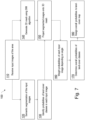
- Figure 7 shows a flow chart illustrating steps of an exemplary embodiment of a method 100 according to the invention.
- predictions of images from several views are combined in 3D space using known camera positions and a 3D mesh. This increases robustness of the resulting land cover.
- Ortho projection is the used to create a 2D land-cover map. This approach not only allows accurate predictions for orthographic view, but also allows classifying areas that are occluded from orthographic view.
- the method starts with receiving 110 a plurality of digital input images of the area, e.g. from the cameras 31-35 shown in Figure 4 .
- Semantic segmentation 120 is performed in each of the input images. For instance, at least ten or twenty land-cover classes are provided that are automatically detected as semantic classes during semantic segmentation.
- a number of possible land-cover classes for each pixel is detected and the probabilities of the possible land-cover classes are identified 130 for each pixel of each input image.
- a 3D mesh of the area is generated 140 using the input images and a structure-from-motion (SfM) algorithm. The identified probabilities are then projected 150 onto this mesh.
- the probabilities provided by the single segmented images for each of their image pixels are then weighted 160 by adding a confidence factor that is based on the respective angle of the image axis relative to the mesh surface.
- this weighting 160 comprises using the cosine of the angle. Since each angle is between 0° and 90°, the respective cosine values are between 1 and 0, wherein a value of 1 means the highest weighting and a value of 0 means the lowest weighting. Right angles are weighted the lowest and acute angles having high cosine values are weighted higher. Consequently, the probabilities of a certain image pixel are weighted the higher the more acute the angle of the respective image axis is relative to the mesh at that surface point of the mesh onto which said image pixel is projected.
- a certain pixel of the map may be visible in three input images. Probabilities of all classes in every image are then multiplied with the angle-dependent weighting value (confidence factor) of the respective image. The resulting values (including both the probability and the confidence factor) of all images can then be used to determine the overall probabilities and assign the most probable land-cover class to the respective pixel of the land-cover map.
- Colours or other graphical indicators such as brightness values or patterns, might be assigned to the land-cover classes, and a land-cover map may be displayed to a user, wherein each pixel has the colour assigned to its most probable land-cover class.
- the colours may be assigned through a user input or pre-defined, e.g. assigning the colours at least partially to allow the user intuitively recognizing the land-cover class from the displayed colour. For instance, trees might be assigned a green colour, streets a grey colour etc.
- FIG. 8 illustrates an exemplary computer system for executing a method according to the invention.
- the depicted computer 4 comprises a processing unit 41 and a storage unit 42.
- the storage unit 42 is configured to store algorithms for executing the method, i.e. SfM algorithms and ML algorithms. It is also configured to store received input data, generated output data and any intermediate data generated in the process.
- the computer 4 receives as input at least the plurality of input images 11-15 of the area and calculates and outputs one or more land-cover maps 20-24 of the area.
- land-cover maps 20-24 may be output on a display of the computer 4, printed and/or provided to other computer systems, e.g. via an Internet connection.
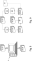
- Figure 9 illustrates a flow of data in a computer system, e.g. the computer 4 of Figure 8 , while performing an exemplary method according to the invention.
- An SfM algorithm 45 of the computer system generates a 3D mesh 25 using the plurality input images 11-15 - and optionally additionally from available depth information or range information.
- Semantic segmentation is performed for each input image 11 of the plurality of input images 11-15 using an ML algorithm 44.
- the resulting segmented images 11'-15' provide sets of single-image probability values 51-55, i.e. probability values for each pixel of the segmented image.
- the segmented images 11'-15' are projected onto the 3D mesh 25 and confidence values 61-65 are assigned to each pixel of the segmented images 11'-15' based on the angle of the image axis of the respective projected segmented image relative to the mesh surface.
- the probability values are averaged to receive a set of overall probability values 50 for each pixel.
- the sets of overall probability values 50 are then assigned to the pixels of the land-cover map(s) 20-24, which may be generated, optionally, based on a received orthoimage 10 of the area.
Landscapes
- Engineering & Computer Science (AREA)
- Physics & Mathematics (AREA)
- Theoretical Computer Science (AREA)
- General Physics & Mathematics (AREA)
- Multimedia (AREA)
- Software Systems (AREA)
- Computer Vision & Pattern Recognition (AREA)
- Geometry (AREA)
- Evolutionary Computation (AREA)
- Remote Sensing (AREA)
- Computer Graphics (AREA)
- Artificial Intelligence (AREA)
- Computing Systems (AREA)
- Databases & Information Systems (AREA)
- General Health & Medical Sciences (AREA)
- Medical Informatics (AREA)
- Health & Medical Sciences (AREA)
- Astronomy & Astrophysics (AREA)
- Computational Linguistics (AREA)
- Image Processing (AREA)
Priority Applications (3)
| Application Number | Priority Date | Filing Date | Title |
|---|---|---|---|
| EP22185206.4A EP4307247A1 (fr) | 2022-07-15 | 2022-07-15 | Procédé permettant de générer des cartes de couverture du sol |
| CN202310856687.8A CN117409155A (zh) | 2022-07-15 | 2023-07-12 | 用于生成土地覆盖地图的方法 |
| US18/222,276 US20240020924A1 (en) | 2022-07-15 | 2023-07-14 | Method for generating land-cover maps |
Applications Claiming Priority (1)
| Application Number | Priority Date | Filing Date | Title |
|---|---|---|---|
| EP22185206.4A EP4307247A1 (fr) | 2022-07-15 | 2022-07-15 | Procédé permettant de générer des cartes de couverture du sol |
Publications (1)
| Publication Number | Publication Date |
|---|---|
| EP4307247A1 true EP4307247A1 (fr) | 2024-01-17 |
Family
ID=82838905
Family Applications (1)
| Application Number | Title | Priority Date | Filing Date |
|---|---|---|---|
| EP22185206.4A Pending EP4307247A1 (fr) | 2022-07-15 | 2022-07-15 | Procédé permettant de générer des cartes de couverture du sol |
Country Status (3)
| Country | Link |
|---|---|
| US (1) | US20240020924A1 (fr) |
| EP (1) | EP4307247A1 (fr) |
| CN (1) | CN117409155A (fr) |
Families Citing this family (3)
| Publication number | Priority date | Publication date | Assignee | Title |
|---|---|---|---|---|
| US20240054731A1 (en) * | 2022-08-10 | 2024-02-15 | Faro Technologies, Inc. | Photogrammetry system for generating street edges in two-dimensional maps |
| WO2025203558A1 (fr) * | 2024-03-29 | 2025-10-02 | 三菱電機株式会社 | Appareil, procédé et programme de détermination de condition de terrain |
| WO2025220170A1 (fr) * | 2024-04-18 | 2025-10-23 | 三菱電機株式会社 | Dispositif de détermination d'état de terrain, procédé de détermination d'état de terrain et programme de détermination d'état de terrain |
Citations (3)
| Publication number | Priority date | Publication date | Assignee | Title |
|---|---|---|---|---|
| US20120041722A1 (en) * | 2009-02-06 | 2012-02-16 | The Hong Kong University Of Science And Technology | Generating three-dimensional models from images |
| US9437034B1 (en) * | 2014-12-15 | 2016-09-06 | Google Inc. | Multiview texturing for three-dimensional models |
| US20190213413A1 (en) * | 2015-08-31 | 2019-07-11 | Cape Analytics, Inc. | Systems and methods for analyzing remote sensing imagery |
Family Cites Families (1)
| Publication number | Priority date | Publication date | Assignee | Title |
|---|---|---|---|---|
| US12350888B2 (en) * | 2019-08-27 | 2025-07-08 | The Regents Of The University Of California | AI-powered autonomous 3D printer |
-
2022
- 2022-07-15 EP EP22185206.4A patent/EP4307247A1/fr active Pending
-
2023
- 2023-07-12 CN CN202310856687.8A patent/CN117409155A/zh active Pending
- 2023-07-14 US US18/222,276 patent/US20240020924A1/en active Pending
Patent Citations (3)
| Publication number | Priority date | Publication date | Assignee | Title |
|---|---|---|---|---|
| US20120041722A1 (en) * | 2009-02-06 | 2012-02-16 | The Hong Kong University Of Science And Technology | Generating three-dimensional models from images |
| US9437034B1 (en) * | 2014-12-15 | 2016-09-06 | Google Inc. | Multiview texturing for three-dimensional models |
| US20190213413A1 (en) * | 2015-08-31 | 2019-07-11 | Cape Analytics, Inc. | Systems and methods for analyzing remote sensing imagery |
Non-Patent Citations (3)
| Title |
|---|
| D. HESTER ET AL.: "Photogrammetric Engineering & Remote Sensing", April 2008, AMERICAN SOCIETY FOR PHOTOGRAMMETRY AND REMOTE SENSING, article "Per-pixel Classification of High Spatial Resolution Satellite Imagery for Urban Land-cover Mapping", pages: 463 - 471 |
| KEMKER RONALD ET AL: "Algorithms for semantic segmentation of multispectral remote sensing imagery using deep learning", ISPRS JOURNAL OF PHOTOGRAMMETRY AND REMOTE SENSING, AMSTERDAM [U.A.] : ELSEVIER, AMSTERDAM, NL, vol. 145, 30 April 2018 (2018-04-30), pages 60 - 77, XP085499063, ISSN: 0924-2716, DOI: 10.1016/J.ISPRSJPRS.2018.04.014 * |
| M. HEROLD ET AL.: "The spectral dimension in urban land cover mapping from high-resolution optical remote sensing data", PROCEEDINGS OF THE 3RD SYMPOSIUM ON REMOTE SENSING OF URBAN AREAS, June 2002 (2002-06-01) |
Also Published As
| Publication number | Publication date |
|---|---|
| US20240020924A1 (en) | 2024-01-18 |
| CN117409155A (zh) | 2024-01-16 |
Similar Documents
| Publication | Publication Date | Title |
|---|---|---|
| US20240020924A1 (en) | Method for generating land-cover maps | |
| US7983474B2 (en) | Geospatial modeling system and related method using multiple sources of geographic information | |
| US20050243323A1 (en) | Method and apparatus for automatic registration and visualization of occluded targets using ladar data | |
| US11922572B2 (en) | Method for 3D reconstruction from satellite imagery | |
| US9576373B2 (en) | Geospatial imaging system providing segmentation and classification features and related methods | |
| JP2020516853A (ja) | ビデオベースの位置決め及びマッピングの方法及びシステム | |
| JP7418281B2 (ja) | 地物の分類システム、分類方法及びそのプログラム | |
| US20210027055A1 (en) | Methods and Systems for Identifying Topographic Features | |
| US12026929B2 (en) | Method for using target pixels to remove objects from texture | |
| US20250166225A1 (en) | Computer Vision Systems and Methods for Detecting Structures Using Aerial Imagery and Heightmap Data | |
| Steinwendner et al. | Vector segmentation using multiband spatial subpixel analysis for object extraction | |
| Bénitez et al. | Automatic production of occlusion-free rectified facade textures using vehicle-based imagery | |
| US12196552B2 (en) | System and method for providing improved geocoded reference data to a 3D map representation | |
| Zhu | A pipeline of 3D scene reconstruction from point clouds | |
| Wan et al. | Tracking of vector roads for the determination of seams in aerial image mosaics | |
| JP5012703B2 (ja) | 目標物検出システム | |
| Wang et al. | Automated Road Extraction and Centreline Fitting in LiDAR Point Clouds | |
| EP4614437A1 (fr) | Projection dynamique de contenu multimédia multidimensionnel | |
| Xie et al. | Urban 3D building model applied to true orthoimage generation | |
| Kraub et al. | Coarse and fast modelling of urban areas from high resolution stereo satellite images | |
| Disa et al. | Ghost effects and obscured areas in true orthophoto generation | |
| Cover | MODELING OF URBAN AREAS FROM HIGH RESOLUTION STEREO SATELLITE IMAGES |
Legal Events
| Date | Code | Title | Description |
|---|---|---|---|
| PUAI | Public reference made under article 153(3) epc to a published international application that has entered the european phase |
Free format text: ORIGINAL CODE: 0009012 |
|
| STAA | Information on the status of an ep patent application or granted ep patent |
Free format text: STATUS: THE APPLICATION HAS BEEN PUBLISHED |
|
| AK | Designated contracting states |
Kind code of ref document: A1 Designated state(s): AL AT BE BG CH CY CZ DE DK EE ES FI FR GB GR HR HU IE IS IT LI LT LU LV MC MK MT NL NO PL PT RO RS SE SI SK SM TR |
|
| STAA | Information on the status of an ep patent application or granted ep patent |
Free format text: STATUS: REQUEST FOR EXAMINATION WAS MADE |
|
| 17P | Request for examination filed |
Effective date: 20240712 |
|
| RBV | Designated contracting states (corrected) |
Designated state(s): AL AT BE BG CH CY CZ DE DK EE ES FI FR GB GR HR HU IE IS IT LI LT LU LV MC MK MT NL NO PL PT RO RS SE SI SK SM TR |
|
| GRAP | Despatch of communication of intention to grant a patent |
Free format text: ORIGINAL CODE: EPIDOSNIGR1 |
|
| STAA | Information on the status of an ep patent application or granted ep patent |
Free format text: STATUS: GRANT OF PATENT IS INTENDED |