EP4375619A2 - Verfahren zur bestimmung eines transportmodus eines von mindestens einem benutzer durchströmten weges - Google Patents
Verfahren zur bestimmung eines transportmodus eines von mindestens einem benutzer durchströmten weges Download PDFInfo
- Publication number
- EP4375619A2 EP4375619A2 EP23209954.9A EP23209954A EP4375619A2 EP 4375619 A2 EP4375619 A2 EP 4375619A2 EP 23209954 A EP23209954 A EP 23209954A EP 4375619 A2 EP4375619 A2 EP 4375619A2
- Authority
- EP
- European Patent Office
- Prior art keywords
- transport
- mode
- steps
- succession
- data
- Prior art date
- Legal status (The legal status is an assumption and is not a legal conclusion. Google has not performed a legal analysis and makes no representation as to the accuracy of the status listed.)
- Pending
Links
Images


Classifications
-
- G—PHYSICS
- G01—MEASURING; TESTING
- G01C—MEASURING DISTANCES, LEVELS OR BEARINGS; SURVEYING; NAVIGATION; GYROSCOPIC INSTRUMENTS; PHOTOGRAMMETRY OR VIDEOGRAMMETRY
- G01C21/00—Navigation; Navigational instruments not provided for in groups G01C1/00 - G01C19/00
- G01C21/20—Instruments for performing navigational calculations
-
- H—ELECTRICITY
- H04—ELECTRIC COMMUNICATION TECHNIQUE
- H04W—WIRELESS COMMUNICATION NETWORKS
- H04W4/00—Services specially adapted for wireless communication networks; Facilities therefor
- H04W4/02—Services making use of location information
- H04W4/024—Guidance services
Definitions
- the field of transport is an essential aspect of daily life on which the global economy depends heavily. However, it also plays a major role in deteriorating air quality and increasing CO 2 emissions, particularly in urban areas. According to the World Health Organization (WHO), transport is one of the main sources of air pollution, and it is directly linked to multiple respiratory and cardiovascular diseases. Additionally, global transportation accounts for around 24% of direct CO2 emissions from fuel combustion, almost three-quarters of which come from cars, trucks, buses and motorcycles, making the problem even worse. of global warming. Other types of harmful emissions include nitrogen oxides (NOx), ground-level ozone (O 3 ) and particulate matter (PM), which generally exceed recommended limits.
- NOx nitrogen oxides
- O 3 ground-level ozone
- PM particulate matter
- Mobility data can be retrieved by different types of sensors including: cellular network, WiFi, Bluetooth and GPS sensor, which were first made available on a mobile phone around the year 1999.
- CDRs which can be translated as call detail recording
- geolocation data for example GPS from the English “Global Positioning System” which can be translated as global positioning system
- the applications for mobility data are innumerable and cover distinct areas such as: exploring mobility patterns, urban and road planning, traffic forecasting, health and transport monitoring, etc.
- an essential characteristic is the mode of transport used, and asking the user to provide information is problematic (lack of motivation or attention, and/or difficulties linked to multimodal travel, etc.).
- GIS geographic information system
- simple heuristic rules are described in particular in the document: STOPHER, P., CLIFFORD, E., ZHANG, J.
- Common transportation mode detection algorithms include: artificial neural networks, Bayesian networks, convolutional neural networks, discrete hidden Markov models, decision trees, expectation maximization techniques, rules of “fuzzy logic” (which can be translated as fuzzy logic), algorithms based on geographic information systems GIS (or in English GIS for “Geography information system”), graphic convolutional networks, “K-nearest neighbors” (which can be translated as K nearest neighbors), logistic regressions, random forests, recurrent neural networks, support vector machines, unsupervised deep learning, etc.
- the input variables of GPS sensors are very varied, they include for example: latitude and longitude pairs, travel time/length, speed, acceleration, jerk and/or heading signal functions (mean, median, standard deviation, percentiles, covariances, etc.), GPS signal quality, stopping rate, “critical point” information, and others.
- latitude and longitude pairs include for example: latitude and longitude pairs, travel time/length, speed, acceleration, jerk and/or heading signal functions (mean, median, standard deviation, percentiles, covariances, etc.), GPS signal quality, stopping rate, “critical point” information, and others.
- the output is the predicted transportation mode or, sometimes, the transportation mode category.
- Most studies are able to detect between four and five modes, and tend to include walking, car and bus (rarely motorbike). Accuracy can reach up to 90%, but interpretation and/or comparison of results between different studies is often meaningless; the datasets used range from a single user and a few trips to hundreds of users, the quality differs and is often unrealistic, the GPS frequency varies considerably (from 1 to 1/30 Hz), etc.
- the first research applies a supervised learning approach which consists of a segmentation method, an inference model (decision tree, Bayesian network, etc.), and a post-processing algorithm based on conditional probability.
- the modes considered are walking, bus, cycling and car.
- a decision tree followed by a first-order hidden Markov model can then be proposed to distinguish between stationary, walking, running, cycling and motorized modes.
- the patent application FR3112398 ( US 2022/010220 ) allows a method of determining a mode of transport of a journey to be determined, by a study of similarity between the acquired route and previous journeys by means of a discrete modified Fréchet distance. The precision and robustness of the determination of the mode of transport obtained by this method can be further improved.
- the present invention aims to determine the mode of transport of a journey traveled by a user in real time (just at the end of the journey), in a robust manner, and taking into account a large number of possible modes of transport, including including the motorcycle.
- the present invention relates to a method for determining the mode of transport of a journey traveled.
- Each step in the succession of steps is linked to a different category of transport mode, with certain steps implementing models trained on time-stamped geolocation learning data.
- the use of one step per category of transport mode within a succession of steps allows for more robustness.
- the use of data-driven models allows for rapid determination, and therefore, real-time usage.
- historical travel data of said user is acquired, and said succession of steps further comprises a step of comparing said time-stamped geolocation data acquired with said historical data, and the mode of transport if the acquired time-stamped geolocation data is similar with said historical data of at least one journey, preferably a similarity is determined by means of calculating a distance, such as the Fréchet distance or the Hausdorff distance.
- said mode of transport is determined from walking, running, cycling, motorcycle, tram, plane, train, metro, motor vehicle and bus.
- the method comprises a prior step of determining at least one descriptor of said path from said acquired time-stamped geolocation data, and at least one step of said succession of steps takes into account said at least one descriptor.
- the determination of a mode of public transport not circulating on a road network is implemented by means of a mapping algorithm and the Hausdorff distance.
- vehicle data belonging to said user is acquired, and said succession of steps is adapted according to said vehicle data belonging to said user.
- said models are trained from time-stamped geolocation data learned by machine learning using at least one neural network.
- said succession of steps first implements the determination of a motorized or non-motorized mode of transport.
- said succession of steps implements the determination of a mode of transport by motorcycle before the determination of a mode of transport by public transport not circulating on a road network and before the determination of a mode of transport circulating on a road network.
- said succession of steps implements the determination of a mode of public transport not circulating on a road network before the determination of a mode of transport circulating on a road network.
- said heuristic filter is based on a statistical analysis of said time-stamped learning geolocation data.
- a mapping algorithm is applied by mode of public transport not circulating on a road network.
- said driven model and/or said heuristic filter further determines the type of non-motorized transport.
- the invention relates to a method for determining a mode of transport of a journey traveled by a user, by means of a geolocation sensor.
- the method determines which means of transport was used for this journey traveled, for example by bicycle, by bus, by train, by motorcycle, etc.
- the journey traveled by the user can be a monomodal journey, that is to say a journey using a single mode of transport between departure and arrival.
- a geolocation sensor is a sensor that measures the user's position as well as the time of measurement. We then speak of time-stamped geolocation. Such a geolocation sensor may use GPS technology, Galliléo technology or any equivalent technology.
- the geolocation sensor can be provided in the smart phone (from the English “smartphone”) of the user, or in a connected watch, or any connected object or any similar object.
- the method according to the invention also uses a set of previous data of journeys traveled (by the same user and/or by other users). For this previous dataset, we know the time-stamped geolocation data as well as the mode of transport that was used. This set of previous data is called, in the remainder of the request, time-stamped geolocation training data.
- the method according to the invention may include a step of acquiring or even measuring time-stamped learning geolocation data.
- Step 1 is implemented by means of the geolocation sensor
- step 2 can be implemented by computer means, such as a computer, a server, or a mobile phone.
- steps will be detailed in the remainder of the description.
- steps can preferably be carried out in real time, that is to say immediately after the end of the journey. Indeed, the process according to the invention can be carried out in a few seconds.
- FIG 1 illustrates, schematically and in a non-limiting manner, the steps of the method according to a first embodiment of the invention.
- There figure 1 illustrates a possible ordering of the steps. However, other orderings are possible.
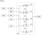
- Within the succession of SET steps we can initially implement a step of determining a non-motorized mode of transport NMO. This NMO step also uses DAP training geolocation data.
- this NMO step determines a non-motorized mode of transport: "yes”, then the succession of steps stops, and the MDT mode of transport is a non-motorized mode of transport. On the contrary, if this NMO step does not determine a non-motorized mode of transport: "no”, then the succession of SET steps continues towards a step of determining a mode of transport by motorcycle MOT, which also uses data from DAP learning geolocation. If this MOT step determines a mode of transport by motorcycle: “yes”, then the succession of SET steps stops, and the mode of transport MDT is a mode of transport by motorcycle.
- this MOT step does not determine a mode of transport by motorcycle: "no”
- the succession of SET steps continues towards a step of determining a mode of public transport outside the TRC road network (for example: train, plane, metro, tram). If this TRC step determines a mode of public transport outside the road network: “yes”, then the succession of SET steps stops, and the mode of transport MDT is a mode of public transport outside the road network.
- this TRC step does not determine a mode of public transport outside the road network: "no”
- the succession of SET steps continues towards a step of determining a mode of transport by motorized vehicle on the road network VER (e.g. bus or motor vehicle), which also uses DAP learning geolocation data. If this step determines a mode of transport by motorized vehicle on the road network: "yes”, then the succession of SET steps stops and the mode of transport MDT is a mode of transport by motorized vehicle on the road network.
- VER e.g. bus or motor vehicle
- the method may comprise a preliminary step of determining at least one descriptor of said route traveled from the acquired time-stamped geolocation data.
- a descriptor may be user speed, user acceleration, specific power, etc.
- the steps of the succession of steps can take into account at least one descriptor of the determined path. Indeed, such a descriptor promotes the implementation of the different stages of the succession of stages.
- Step 1' can also be implemented by computer means, in particular a computer, a server or a mobile telephone. These steps will be detailed in the remainder of the description.
- the step of the succession of steps of determining a mode of public transport outside the road network can be carried out by means of at least one geographic information system GIS (or in English GIS for “Geography information system”).
- GIS geographic information system
- Such a geographic information system may include the tracks of at least one mode of public transport outside the road network, for example railway tracks, metro tracks, the positioning of airports, etc.
- the method includes an additional step of determining at least one DES descriptor of the route traveled from GPS time-stamped geolocation data. This step of determining at least one DES descriptor is also applied to the DAP learning geolocation data. The at least one DES descriptor is implemented in the different stages of the succession of SET stages.
- a GIS geographic information system is used for the step of determining a mode of public transportation outside the TRC road network.
- the method can implement a step of acquiring data from the user's vehicles, and can adapt the succession of steps by adapting the steps according to the data from the user's vehicles. the user.
- the user For example, it is possible to acquire, in particular by means of a man-machine interface, all the vehicles belonging to a user, for example: motorcycle, bicycle, motor vehicle, etc.
- This data can then be used in the succession of steps to to improve the accuracy of determining the mode of transport. Indeed, a mode of transport for which the user owns a vehicle becomes more likely.
- the method can implement a step of acquiring the history of the user's journeys.
- the user's travel history may include time-stamped geolocation data associated with a mode of transportation.
- the succession of steps may include an additional step of determining the mode of transport by comparing the route traveled with the user's historical journey data.
- This additional step can also make it possible to reduce the time for determining the mode of transport, because fewer steps in the succession of steps can be useful.
- Step 2.5 can also be implemented by computer means, in particular a computer, a server or a mobile telephone. These steps will be detailed in the remainder of the description.
- FIG. 3 illustrates, schematically and in a non-limiting manner, the steps of the method according to this third embodiment.
- the steps described in relation to the figure 1 or the figure 2 are not re-detailed.
- This figure illustrates a combination of the two configurations described above (acquiring the user's vehicles and acquiring the user's travel histories), however, these realizations are independent and can be applied alone.
- at least one vehicle belonging to to the user GAR, and in at least one step of the succession of steps, for example the step of determining a mode of transport by motorcycle MOT, the vehicle belonging to the user is taken into account.
- the succession of SET steps includes an additional COM comparison step of the acquired GPS geolocation data and the HIS historical data.
- this comparison step COM is carried out between the step of determining a mode of transport by motorcycle MOT and the step of determining a mode of public transport outside the TRC road network.
- this step can be carried out at another location in the succession of steps, for example first. If this COM comparison makes it possible to identify a “yes” mode of transport, then the MDT mode of transport is that identified by the COM comparison, and the succession of SET steps ends. On the contrary, if this COM comparison does not make it possible to identify a “no” mode of transport, then the succession of SET steps continues with the next step, for the embodiment illustrated by the step of determining transport in common outside the TRC road network.
- the step of determining a mode of public transport outside the road network may comprise several sub-steps, each sub-step relating to the determination of a single mode of public transport outside the road network.
- the step of determining a mode of public transport outside the road network may include a sub-step of determining a mode of transport by plane, and/or a sub-step of determining a mode of transport by train and/or a sub-step of determining a mode of transport by tram and/or a sub-step of determining transport by metro, etc.
- the step of determining a mode of motorized transport on the road network may comprise several sub-steps, each sub-step relating to the determination of a single mode of motorized transport on the road network.
- the step of determining a mode of motorized transport on a road network may comprise a sub-step of determining a mode of transport by motor vehicle and/or a sub-step of determining a bus mode of transport.
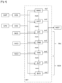
- FIG. 4 illustrates, schematically and in a non-limiting manner, the steps of the method according to this fourth embodiment.
- the steps described in relation to the figures 1 to 3 are not re-detailed.
- This figure illustrates a combination of the two configurations described above (sub-steps for determining the mode of public transport and sub-steps for determining the mode of motorized transport on the road network), however, these achievements are independent and can be applied alone.
- the succession of SET steps includes a step of determining a mode of public transport outside the TRC road network.
- This step of determining a mode of public transport outside the TRC road network comprises a sub-step of determining a mode of transport by plane AVI, a sub-step of determining a mode of transport by tramway TRM and a sub-step of determining a TRN train transport mode.
- Each of these sub-steps can take into account data from a GIS geographic information system.
- each sub-step can implement a different geographic information system, denoted respectively SIG1, SIG2, SIG3.
- a single GIS geographic information system can be used for all three substeps. If the AVI substep determines a mode of public transport by plane: “yes”, then the succession of SET steps stops, and the mode of transport MDT is a mode of transport by plane.
- this AVI sub-step does not determine a mode of public transport by plane, then the succession of SET steps continues towards a sub-step of determining a mode of transport by TRM tram. If this TRM sub-step determines a mode of public transport by tram: “yes”, then the succession of SET steps stops, and the mode of transport MDT is a mode of transport by tram. On the contrary, if this TRM sub-step does not determine a mode of public transport by tram, then the succession of SET steps continues towards a sub-step of determining a mode of transport by train TRN. If this TRN substep determines a mode of public transport by train: “yes”, then the succession of SET steps stops and the mode of transport MDT is a mode of transport by train.
- this TRN sub-step does not determine a mode of public transport by train, then the succession of SET steps continues towards a step of determining a mode of transport by vehicle on a road network VER.
- This step of determining a mode of transport by vehicle on a road network VER comprises a sub-step of determining a mode of transport by motor vehicle AUT, and a sub-step of determining a mode of transport by bus BUS. If this substep AUT determines a mode of transport by motor vehicle: “yes”, then the succession of steps SET stops, and the mode of transport MDT is a mode of transport by motor vehicle.
- this AUT substep does not determine a mode of transport by motor vehicle, then the succession of SET steps continues towards a substep of determining a mode of transport by bus BUS. If this BUS substep determines a bus mode of public transport: “yes”, then the succession of SET steps stops, and the MDT mode of transport is a bus mode of transport.
- the mode of carrying out the Figure 4 can be combined with one of the configurations of the Figure 3 : acquisition of vehicle data belonging to the user and/or acquisition of historical data of journeys traveled by the user and implementation of a comparison step.
- time-stamped geolocation data is acquired from the route traveled by the user, using the geolocation sensor.
- the acquisition of the time-stamped geolocation data may include the implementation of the measurement during the journey of the time-stamped geolocation.
- time-stamped geolocation data of the route traveled by the user is measured, using the geolocation sensor.
- the time-stamped geolocation data of the route traveled by the user can be recorded on a smartphone, a connected object, a computer or a server.
- this step of acquiring time-stamped geolocation data may include a step of pre-processing the data.
- Data pre-processing may include removing outliers, completing the trajectory, for example by an interpolation method, and filtering the data.
- At least one descriptor of the route is determined using the time-stamped geolocation data acquired from the route traveled (and possibly preprocessed).
- a descriptor is a characteristic of the journey that is deduced from time-stamped geolocation data. This optional step makes it possible to obtain characteristics of the route traveled, which can help determine the mode of transport. For example, an average speed may be a useful characteristic for determining a non-motorized mode of transportation.
- a descriptor can be defined by a function as a function of time. This may be the acceleration as a function of time.
- the method can also determine at least one pre-descriptor.
- the pre-descriptors are optionally multidimensional vectors that are used to define the one-dimensional scalars.
- the important functions of the pre-descriptors may include the following: distances between consecutive points obtained by the geolocation sensor, cumulative total distance, speed, acceleration, specific power and jerk signals, stopping and near-stopping positions ( a short partial stop of a journey, which may correspond to a break induced by a red light), etc.
- the important functions of the descriptors can be the following: functions of speed, acceleration, specific power and jerk, such as averages, standard deviations, maximums, averages on the positive points/ negative or after stopping, different percentiles, entropies; stopping frequency, average/deviation of distance between stopping points; several different measurements of the quality of the geolocation signal, etc. Therefore, this step results in a large number of preprocessed values that describe the main properties of the traveled path.
- a mode of transport for the route traveled is determined by means of time-stamped geolocation data, and possibly by means of the descriptors determined in step 1', by means of a succession of steps.
- the steps in the succession of steps are carried out until a mode of transport is determined. In other words, once a step has identified a mode of transport, the other steps are not carried out.
- Each step makes it possible to determine a mode of transport category. The specificity of each step allows better precision of the determination.
- This succession of stages can be considered as a sequence of “divide and conquer”. This succession of steps makes it possible to not have to carry out all the steps for each journey, which simplifies the implementation of determining the mode of transport. Furthermore, at each stage, the number of possible modes of transport is increasingly restricted, which promotes reliability and robustness in determining the mode of transport.
- a step of determining at least one descriptor can be implemented for the time-stamped geolocation training data, preferably in accordance with step 1') described above.
- the term learning geolocation database includes the at least one determined descriptor.
- the succession of steps can first implement the determination of the mode of motorized transport or not.
- a first discrimination of the mode of transport can be implemented.
- the journey traveled is not determined in non-motorized mode of transport, only motorized modes of transport remain.
- the succession of steps can implement the determination of a mode of transport by motorcycle before the determination of a mode of common transport outside a road network, and before the determination of a mode of transport by vehicle motorized on a road network.
- this step can be implemented after the step of determining a mode of public transport outside the road network.
- the succession of steps can implement the determination of a mode of public transport outside the road network before the step of determining a mode of motorized transport on the road network.
- the determination of a mode of public transport outside the road network can be implemented after the step of determining a mode of motorized transport on the road network.
- the step of comparison between the historical data and the acquired time-stamped geolocation data can be implemented at the start of the succession of steps, to avoid carrying out other steps, if the comparison step makes it possible to directly determine a mode of transport.
- this step can be carried out directly after the step of determining the modes of motorized transport and/or directly after the step of determining a mode of transport by motorcycle. The earlier this step is implemented in the succession of steps, the more it can avoid carrying out a number of steps if this comparison determines a mode of transport.
- step 1 we determine, based on the geolocation data acquired in step 1, whether the journey traveled is made in a non-motorized mode of transport, by means of a model trained from the time-stamped geolocation data d learning and/or by means of a heuristic filter constructed from time-stamped geolocation training data.
- the trained model and/or the heuristic filter can also determine a probability of a non-motorized mode of transport, chosen in particular between walking, running and cycling. We can then determine a mode of transport in the case of a probability greater than a predetermined threshold.
- this step can implement both the trained model and the heuristic filter for verification of the results, which allows good reliability of the detection of a non-motorized or motorized mode of transport.
- a trained model is a model built from data.
- the model can be trained from time-stamped geolocation data using machine learning.
- the training time-stamped geolocation data forms a training base for machine learning.
- machine learning may be an artificial neural network.
- machine learning can leverage other machine learning methods.
- the neural network can comprise an input layer with a number of nodes corresponding to the number of descriptor, two hidden layers of respective sizes eight and four, and an output layer providing the probabilities of each mode.
- Activation functions can be Rectified Linear Unit (ReLU) and Softmax, optimizer can be adaptive moment estimation (Adam), loss function can be categorical cross entropy, maximized metric precision, L2 regularization to avoid overfitting.
- ReLU Rectified Linear Unit
- Softmax Softmax
- optimizer can be adaptive moment estimation (Adam)
- loss function can be categorical cross entropy, maximized metric precision, L2 regularization to avoid overfitting.
- the heuristic filter is based on a statistical analysis of said learning geolocation data.
- the heuristic filter is a set of simple and conservative conditions on selected characteristics and based on statistical analyses. Its main goal is to avoid aberrant errors that can disrupt the user experience.
- the output is a vector of possible modes remaining after elimination.
- step 1 we determine, based on the geolocation data acquired in step 1, whether the journey traveled is made in a motorcycle mode of transport, by means of a model trained from the time-stamped geolocation data d 'learning.
- a trained model is a model built from data. This model can give a probability of a trip traveled by motorcycle.
- the model can be trained from time-stamped geolocation data using machine learning.
- the training time-stamped geolocation data forms a training base for machine learning.
- machine learning may be an artificial neural network.
- the artificial neural network can comprise an input layer with a number of nodes corresponding to the number of descriptors, two hidden layers of respective sizes eight and four, and an output layer providing the probability of the mode of motorcycle transportation.
- Activation functions can be Rectified Linear Unit (ReLU) and Softmax, optimizer can be adaptive moment estimation (Adam), loss function can be categorical cross entropy, maximized metric precision, L2 regularization to avoid overfitting.
- ReLU Rectified Linear Unit
- Softmax Softmax
- optimizer can be adaptive moment estimation (Adam)
- loss function can be categorical cross entropy, maximized metric precision, L2 regularization to avoid overfitting.
- the probability of the motorcycle mode of transport obtained by the trained model can be increased.
- the mode of transport is determined as a motorcycle.
- mapping algorithm we determine, based on the geolocation data acquired in step 1, whether the journey traveled is made in a mode of public transport outside the road network, by means of at least one mapping algorithm (from the English “mapmatching” can also be translated as geographic correspondence).
- GIS geographic information system
- Maps TM , Google Maps TM , OpenStreetMap TM , etc. are examples of GIS geographic information systems.
- GIS geographic information system can contain the dedicated lanes of public transport modes outside the road network, for example railways, the position of airports, etc.
- the step of determining a mode of public transport outside the road network may comprise several sub-steps, each sub-step relating to the determination of a single mode of public transport outside the road network.
- the step of determining a mode of public transport outside the road network may include a sub-step of determining a mode of transport by plane, and/or a sub-step of determining a mode of transport by train and/or a sub-step of determining a mode of transport by tram and/or a sub-step of determining transport by metro, etc.
- a mapping algorithm can be applied by mode of public transport outside the road network.
- a geographic information system per mode of transport can be provided, or a single geographic information system which includes all the modes of transport considered.
- the similarity between the route traveled and the specific route identified by the GIS can be obtained by means of a determined distance between the route and the route identified for example by means of the Hausdorff distance.
- the sub-step of determining a mode of transport by plane can be based on cartographic and standard conditions. Standard conditions can be based on descriptors such as cumulative total distance and average speed or above a filtered signal. Map conditions can be intersection-based and can use the entire trajectory, relatively small neighborhoods around trajectory start and end points, and the geographic position of multiple airports around the world. As a result, this sub-step is capable of providing a binary response indicating whether the path corresponds to an aircraft or not. In the first case, according to one embodiment, a degree of confidence can also be given (for example low, medium or high).
- this sub-step may contain an additional trajectory cleaning operation, for example to remove repeated geolocation points.
- the main tool for map matching in this case can be the Hausdorff distance between the tram rail network and the route traveled (with the acquired time-stamped geolocation data).
- the path traveled can be called trajectory.
- the Hausdorff distance is a popular choice for measuring the similarity between geometric objects.
- this sub-step can follow the following steps: 1) an expansion of the trajectory is intersected with the tram network, 2) we measure the Hausdorff distance between the trajectory and this intersection, 3) we define an overlap tram as the ratio between: 3.1) the number of points of the trajectory inside a dilated version of the previous intersection (the dilation depends on the precision of the signal), and 3.2) the number of points of the trajectory , 4) we define the weighted Hausdorff distance as the ratio between the Hausdorff distance and the railway coverage determined in 3). Finally, a threshold on the distance is set in order to determine whether a trajectory is carried out by a tram or not, in other words whether the mode of transport is the tram or not.
- the same operations can be implemented as those for the tramway.
- the difference may lie in the parameter setting, in particular, the distance threshold can be considerably larger.
- the same operations can be implemented as those for the tramway.
- the difference may lie in the parameter setting, for example the distance threshold.
- step 1 we determine, based on the geolocation data acquired in step 1, whether the journey traveled is made in a mode of transport by motorized vehicle on the road network, by means of at least one model trained from time-stamped geolocation training data.
- a trained model is a model built from data.
- the model can be trained from time-stamped geolocation data using machine learning.
- the training time-stamped geolocation data forms a training base for machine learning.
- machine learning may be an artificial neural network.
- the artificial neural network may comprise an input layer with one node per descriptor, two hidden layers of size eight and four, and an output layer providing the probability of the mode of transport by bus or vehicle.
- Activation functions can be Rectified Linear Unit (ReLU) and Softmax, Optimizer can be Adaptive Moment Estimation (Adam), Loss Function can be Categorical Cross Entropy, Maximized Metric Precision, Regularization L2 to avoid overfitting.
- this step may include a sub-step of determining a mode of transport by motor vehicle and a sub-step of determining a mode of transport by bus. This makes it easier to discriminate between the mode of transport used.
- a product of two neural networks can be implemented: a first neural network trained to distinguish the motor vehicle of the bus (for this first neural network, the descriptors may include the number of stops per kilometer, the average and standard deviation of the speed, a percentile of the highest speeds, the specific power, etc. .), and the second neural network trained to distinguish the motor vehicle from the motorcycle (for this second neural network, the descriptors can be in particular the average acceleration for the points where the speed is positive, the average acceleration after a stop, specific power, maximum acceleration, etc.). Thanks to these two neural networks, the determination of a mode of transport in a motor vehicle is reliable.
- a neural network which determines one or two specific characteristics. For the first characteristic, a score can be determined based on the proximity of the trajectory of the geolocation data to nearby bus stops (which can be obtained by map information, for example by means of a geographic information system). . For the second characteristic, we can determine, where appropriate (for the embodiment for which historical travel data of the user is acquired), a ratio between the number of bus journeys over the total number of journeys made by the user. 'user.
- the user's trip history may include, for previous trips, the user's time-stamped geolocation data with which a mode of transportation is associated.
- the succession of steps may include an additional step of determining the mode of transport by comparing the route traveled with the user's historical journey data.
- This additional step can also make it possible to reduce the time for determining the mode of transport, because fewer steps in the succession of steps can be useful.
- the mode of transport can be determined by means of a similarity between the route traveled and at least one route in the history.
- This similarity can be determined by a distance between the route traveled and a route in the history, the distance can for example be a Hausdorff distance (in particular when comparing speed signals) or a Fréchet distance (in particular when comparing geolocation data).
- certain data collection rules can be set to find a subset of candidate history journeys among those carried out by the user. Then, we can classify these paths according to a notion of similarity and overlap between the pairs of paths.
- the notion used may be a modified version of the discrete Fréchet distance which was notably described in the patent application FR3112398 ( US 2022/010220 ), in particular in the section “Determination of the discrete modified Fréchet distance”. This distance makes it possible to measure the similarity between two multi-dimensional trajectories, of possibly different sizes, on the basis of an optimized association of their points.
- the so-called optimal matching between the trajectories can also be obtained explicitly. For example, instead of considering the maximum, we can use the average distance which is more robust to remaining aberrations in the geolocation trajectories. As a by-product, the same association of points gives rise to a notion of trajectory coverage. Finally, in order to avoid errors in labeling spatially similar journeys made on different modes of transport, the method can be reinforced with the so-called Hausdorff distance between the corresponding speed signals. If this step is able to find a satisfactory historical route candidate, the transport mode of this historical route is assigned to the traveled route.
- the invention thus aims to analyze the mobility of people, and more precisely their choice of mode of transport for their trips, in order to note the impacts of mobility on pollutant emissions and air quality. . It can thus make it possible to determine pollutant emissions.
- Another object of the invention consists of monitoring the evolution of people's choices of mode of transport during their travels over time in order to evaluate the strategies put in place by public authorities (road developments, public transport, soft mobility) and to guide the development choices of road developments, public transport and soft mobility according to users' modes of transport.
- the invention can be used to determine the transport mode choices of users in a geographical area more regularly (e.g. every month), without having to wait for new statistical surveys (household-travel surveys carried out every 5 to 10 years old).
- the process is applied according to the mode of carrying out the figure 4 , with regard to the ordering of the steps of the succession of steps, by adding the comparison step to the user's historical journey data (step 2.5) as illustrated in Figure 3 .
- the method implements a step of pre-processing the acquired time-stamped geolocation data.
- the Geolocation data used for learning represents approximately 90 million km traveled with an identified mode of transport.
- the geographic information system is OpenStreetMap TM .
- time-stamped geolocation data of a first journey are acquired by means of a GPS system present on a smartphone. Identifying the mode of transport for this trajectory is particularly difficult: short and relatively slow trajectory within a city and close to rail networks. For the acquired journey, we obtain a total duration of approximately 25 min and a total distance of approximately 7 km.
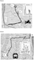
- FIG. 5 illustrates, schematically, on a road map the route acquired between a starting point D and an arrival A. This Figure 5 also illustrates a descriptor of the acquired journey: the speed of the vehicle.
- recorded GPS points remain affected by noise and associated path characteristics can be misleading when considered in isolation. This further complicates the task of determining the mode of transport.
- the heuristic filter works with the neural network for the non-motorized mode of transport to eliminate the non-motorized modes of transport: walking, running, cycling and scootering. Indeed, the probability of a motorized mode of transport given by this model is close to one. Then, the neural network of a motorcycle mode of transportation determines a probability of 0.88, which is much higher than the corresponding predetermined threshold set at 0.65. Consequently, the succession of steps stops at this stage and determines the “motorcycle” mode of transport. The user approved this classification manually. Consequently, the method according to the invention makes it possible to identify the correct mode of transport used.
- time-stamped geolocation data is acquired from a second route using a GPS system present on a smartphone.
- FIG. 6 illustrates, schematically, on a road map the route acquired between a starting point D and an arrival A.
- This Figure 6 also illustrates a descriptor of the acquired journey: the speed of the vehicle.
- the heuristic filter works with the neural network for the non-motorized mode of transport to eliminate the modes of transport: walking, running, cycling and scootering. Indeed, the probability of a motorized mode of transport given by this model is close to 0.65. Then, the neural network of a motorcycle mode of transport determines a probability of 0.2, which is much lower than the corresponding predetermined threshold fixed at 0.65.
- the comparison step (using the discrete Fréchet distance) with historical trip data is not conclusive.
- the mapping algorithms with the plane and the train respectively do not make it possible to determine the mode of transport: no correspondence is found between polygons of an airport or with train rails. Then a match is found by the mapping algorithm with the tram, with a matching distance of 0.3 units and a rail coverage of 70%. Therefore, the succession stops at this stage and determines the "tram" mode of transport. The user approved this classification manually. Consequently, the method according to the invention makes it possible to identify the correct mode of transport used.
- time-stamped geolocation data from a third route are acquired using a GPS system present on a smartphone.
- FIG 7 illustrates, schematically on a road map, the journey acquired between a starting point D and an arrival A.
- This figure 7 also illustrates a descriptor of the acquired journey: the speed of the vehicle.
- the heuristic filter works with the neural network for the non-motorized mode of transport to eliminate the modes of transport: walking, running, cycling and scootering. Indeed, the probability of a motorized mode of transport given by this model is close to 0.7. Then, the neural network of a motorcycle mode of transportation determines a probability of 0.3, which is much lower than the corresponding fixed threshold of 0.65.
- the comparison step (by means of the discrete Fréchet distance) with historical journey data makes it possible to identify a similarity with a historical journey taken in a motor vehicle. Consequently, the succession stops at this stage and determines the mode of transport “motor vehicle”. The user approved this classification manually. Consequently, the method according to the invention makes it possible to identify the correct mode of transport used.
- the succession of steps had continued, the same mode of transport would have been identified: the plane, tram and train connections are beyond the correspondence threshold, unlike the product of the two neural networks to identify a mode of transport by motor vehicle.
Landscapes
- Engineering & Computer Science (AREA)
- Radar, Positioning & Navigation (AREA)
- Remote Sensing (AREA)
- Computer Networks & Wireless Communication (AREA)
- Signal Processing (AREA)
- Automation & Control Theory (AREA)
- Physics & Mathematics (AREA)
- General Physics & Mathematics (AREA)
- Navigation (AREA)
- Position Fixing By Use Of Radio Waves (AREA)
- Traffic Control Systems (AREA)
Applications Claiming Priority (1)
| Application Number | Priority Date | Filing Date | Title |
|---|---|---|---|
| FR2212388A FR3142643B1 (fr) | 2022-11-28 | 2022-11-28 | Procédé de détermination d’un mode de transport d’un trajet parcouru par au moins un utilisateur |
Publications (2)
| Publication Number | Publication Date |
|---|---|
| EP4375619A2 true EP4375619A2 (de) | 2024-05-29 |
| EP4375619A3 EP4375619A3 (de) | 2024-08-07 |
Family
ID=85569771
Family Applications (1)
| Application Number | Title | Priority Date | Filing Date |
|---|---|---|---|
| EP23209954.9A Pending EP4375619A3 (de) | 2022-11-28 | 2023-11-15 | Verfahren zur bestimmung eines transportmodus eines von mindestens einem benutzer durchströmten weges |
Country Status (2)
| Country | Link |
|---|---|
| EP (1) | EP4375619A3 (de) |
| FR (1) | FR3142643B1 (de) |
Citations (2)
| Publication number | Priority date | Publication date | Assignee | Title |
|---|---|---|---|---|
| US20220010220A1 (en) | 2020-07-08 | 2022-01-13 | Axens | Process for Hydroprocessing of Biological Feedstocks |
| FR3112398A1 (fr) | 2020-07-08 | 2022-01-14 | IFP Energies Nouvelles | Procédé de caractérisation d’un trajet parcouru par un utilisateur |
-
2022
- 2022-11-28 FR FR2212388A patent/FR3142643B1/fr active Active
-
2023
- 2023-11-15 EP EP23209954.9A patent/EP4375619A3/de active Pending
Patent Citations (2)
| Publication number | Priority date | Publication date | Assignee | Title |
|---|---|---|---|---|
| US20220010220A1 (en) | 2020-07-08 | 2022-01-13 | Axens | Process for Hydroprocessing of Biological Feedstocks |
| FR3112398A1 (fr) | 2020-07-08 | 2022-01-14 | IFP Energies Nouvelles | Procédé de caractérisation d’un trajet parcouru par un utilisateur |
Non-Patent Citations (1)
| Title |
|---|
| GONZALEZ, P.A. ET AL.: "Automating mode détection for travel behaviour analysis by using global positioning systems enabled mobile phones and neural networks", INTELLIGENT TRANSPORT SYSTEMS, 2010 |
Also Published As
| Publication number | Publication date |
|---|---|
| EP4375619A3 (de) | 2024-08-07 |
| FR3142643B1 (fr) | 2024-12-13 |
| FR3142643A1 (fr) | 2024-05-31 |
Similar Documents
| Publication | Publication Date | Title |
|---|---|---|
| EP4075408A1 (de) | Verfahren zur bestimmung der menge der von einem fahrzeug auf einem strassenabschnitt ausgestossenen schadstoffemissionen | |
| EP3462404A1 (de) | Verfahren zur bestimmung der indikatoren für die verschmutzung durch verkehrsmittel unter berücksichtigung der tatsächlichen benutzung | |
| EP3936824A1 (de) | Verfahren zur charakterisierung einer von einem nutzer zurückgelegten strecke | |
| WO2020239503A1 (fr) | Procede de prediction d'au moins un profil de la vitesse d'un vehicule sur un reseau routier | |
| WO2020058234A1 (fr) | Dispositif de prédiction de trajet le plus probable d'un véhicule | |
| EP4181100A1 (de) | Verfahren zur bestimmung eines maximalen durchsatzes und/oder eines logistischen durchflusses von fahrzeugen auf einem strassennetz | |
| EP2235477A1 (de) | Schätzung des kürzesten weges auf zeitbasis in einem strassennetzwerk | |
| CN110969861A (zh) | 一种车辆识别方法、装置、设备及计算机存储介质 | |
| FR3076775A1 (fr) | Procede d'optimisation du profil de vitesse d'un vehicule ferroviaire et dispositifs associes | |
| EP4239289A1 (de) | Verfahren zur bestimmung mindestens einer route zwischen einem geographischen gebiet der herkunft und einem geografischen zielbereich | |
| Dabbas et al. | Benchmarking machine learning algorithms by inferring transportation modes from unlabeled GPS data | |
| EP4261802B1 (de) | Verfahren zur bestimmung einer fahrzeuggeschwindigkeit auf mindestens einem strang eines strassennetzes aus geolokationsdaten | |
| EP4195709A1 (de) | Verfahren zur bestimmung eines transportmodus eines von einem benutzer durchströmten weges | |
| EP2861937A1 (de) | Verfahren zur schätzung einer reisezeit eines fahrzeugs auf einem strassennetz | |
| FR3142643A1 (fr) | Procédé de détermination d’un mode de transport d’un trajet parcouru par au moins un utilisateur | |
| EP4575943A1 (de) | Verfahren zur bestimmung einer menge mindestens eines von einem satz von fahrzeugen in einem strassennetz abgegebenen schadstoffes | |
| EP4198941A1 (de) | Verfahren zur vorhersage mindestens eines geschwindigkeitsprofils eines fahrzeugs für eine bewegung in einem strassennetz | |
| EP4229618B1 (de) | Verfahren zur auswahl von informationselementen zur übertragung an ein bordsystem eines fahrzeugs und zugehörige vorrichtung | |
| FR3152602A1 (fr) | Procédé de regroupement de trajets parcourus | |
| EP4572281A1 (de) | Verfahren zur bestimmung einer übertragungsrate und/oder schadstoffemissionen auf mindestens einem netzstrang | |
| CN116340446B (zh) | 出行方式确定方法、装置及非易失性存储介质 | |
| EP4621644A1 (de) | Verfahren zur bestimmung eines fahrzeugdurchsatzes über ein strassennetz | |
| FR3088113A1 (fr) | Procede de prediction du prochain trajet d’une personne | |
| EP4488626A1 (de) | Verfahren zur bestimmung einer ähnlichkeit zwischen einem durchströmten pfadpaar | |
| Javaheri et al. | Predicting Micromobility Demand in University Campus Environments |
Legal Events
| Date | Code | Title | Description |
|---|---|---|---|
| PUAI | Public reference made under article 153(3) epc to a published international application that has entered the european phase |
Free format text: ORIGINAL CODE: 0009012 |
|
| STAA | Information on the status of an ep patent application or granted ep patent |
Free format text: STATUS: THE APPLICATION HAS BEEN PUBLISHED |
|
| AK | Designated contracting states |
Kind code of ref document: A2 Designated state(s): AL AT BE BG CH CY CZ DE DK EE ES FI FR GB GR HR HU IE IS IT LI LT LU LV MC ME MK MT NL NO PL PT RO RS SE SI SK SM TR |
|
| PUAL | Search report despatched |
Free format text: ORIGINAL CODE: 0009013 |
|
| AK | Designated contracting states |
Kind code of ref document: A3 Designated state(s): AL AT BE BG CH CY CZ DE DK EE ES FI FR GB GR HR HU IE IS IT LI LT LU LV MC ME MK MT NL NO PL PT RO RS SE SI SK SM TR |
|
| RIC1 | Information provided on ipc code assigned before grant |
Ipc: H04W 4/02 20180101ALI20240703BHEP Ipc: G01C 21/20 20060101AFI20240703BHEP |
|
| STAA | Information on the status of an ep patent application or granted ep patent |
Free format text: STATUS: REQUEST FOR EXAMINATION WAS MADE |
|
| 17P | Request for examination filed |
Effective date: 20250207 |
|
| STAA | Information on the status of an ep patent application or granted ep patent |
Free format text: STATUS: EXAMINATION IS IN PROGRESS |
|
| 17Q | First examination report despatched |
Effective date: 20250722 |