EP4394323A1 - Verfahren, vorrichtung und computerprogrammprodukt zur mindestens ungefähren intelligenten echtzeitlückenplatzierung in mobilitätsdaten mit anhand von merkmalen der mobilitätsdaten abgeleiteten übergängen - Google Patents
Verfahren, vorrichtung und computerprogrammprodukt zur mindestens ungefähren intelligenten echtzeitlückenplatzierung in mobilitätsdaten mit anhand von merkmalen der mobilitätsdaten abgeleiteten übergängen Download PDFInfo
- Publication number
- EP4394323A1 EP4394323A1 EP23212394.3A EP23212394A EP4394323A1 EP 4394323 A1 EP4394323 A1 EP 4394323A1 EP 23212394 A EP23212394 A EP 23212394A EP 4394323 A1 EP4394323 A1 EP 4394323A1
- Authority
- EP
- European Patent Office
- Prior art keywords
- data points
- probe data
- location probe
- sequence
- location
- Prior art date
- Legal status (The legal status is an assumption and is not a legal conclusion. Google has not performed a legal analysis and makes no representation as to the accuracy of the status listed.)
- Pending
Links
Images




Classifications
-
- G—PHYSICS
- G01—MEASURING; TESTING
- G01C—MEASURING DISTANCES, LEVELS OR BEARINGS; SURVEYING; NAVIGATION; GYROSCOPIC INSTRUMENTS; PHOTOGRAMMETRY OR VIDEOGRAMMETRY
- G01C21/00—Navigation; Navigational instruments not provided for in groups G01C1/00 - G01C19/00
- G01C21/26—Navigation; Navigational instruments not provided for in groups G01C1/00 - G01C19/00 specially adapted for navigation in a road network
-
- G—PHYSICS
- G06—COMPUTING OR CALCULATING; COUNTING
- G06F—ELECTRIC DIGITAL DATA PROCESSING
- G06F21/00—Security arrangements for protecting computers, components thereof, programs or data against unauthorised activity
- G06F21/60—Protecting data
- G06F21/62—Protecting access to data via a platform, e.g. using keys or access control rules
- G06F21/6218—Protecting access to data via a platform, e.g. using keys or access control rules to a system of files or objects, e.g. local or distributed file system or database
- G06F21/6245—Protecting personal data, e.g. for financial or medical purposes
- G06F21/6254—Protecting personal data, e.g. for financial or medical purposes by anonymising data, e.g. decorrelating personal data from the owner's identification
-
- G—PHYSICS
- G01—MEASURING; TESTING
- G01C—MEASURING DISTANCES, LEVELS OR BEARINGS; SURVEYING; NAVIGATION; GYROSCOPIC INSTRUMENTS; PHOTOGRAMMETRY OR VIDEOGRAMMETRY
- G01C21/00—Navigation; Navigational instruments not provided for in groups G01C1/00 - G01C19/00
- G01C21/38—Electronic maps specially adapted for navigation; Updating thereof
- G01C21/3804—Creation or updating of map data
- G01C21/3807—Creation or updating of map data characterised by the type of data
-
- G—PHYSICS
- G01—MEASURING; TESTING
- G01C—MEASURING DISTANCES, LEVELS OR BEARINGS; SURVEYING; NAVIGATION; GYROSCOPIC INSTRUMENTS; PHOTOGRAMMETRY OR VIDEOGRAMMETRY
- G01C21/00—Navigation; Navigational instruments not provided for in groups G01C1/00 - G01C19/00
- G01C21/38—Electronic maps specially adapted for navigation; Updating thereof
- G01C21/3804—Creation or updating of map data
- G01C21/3833—Creation or updating of map data characterised by the source of data
- G01C21/3841—Data obtained from two or more sources, e.g. probe vehicles
-
- G—PHYSICS
- G01—MEASURING; TESTING
- G01C—MEASURING DISTANCES, LEVELS OR BEARINGS; SURVEYING; NAVIGATION; GYROSCOPIC INSTRUMENTS; PHOTOGRAMMETRY OR VIDEOGRAMMETRY
- G01C21/00—Navigation; Navigational instruments not provided for in groups G01C1/00 - G01C19/00
- G01C21/38—Electronic maps specially adapted for navigation; Updating thereof
- G01C21/3885—Transmission of map data to client devices; Reception of map data by client devices
- G01C21/3896—Transmission of map data from central databases
-
- G—PHYSICS
- G08—SIGNALLING
- G08G—TRAFFIC CONTROL SYSTEMS
- G08G1/00—Traffic control systems for road vehicles
- G08G1/01—Detecting movement of traffic to be counted or controlled
- G08G1/0104—Measuring and analyzing of parameters relative to traffic conditions
- G08G1/0108—Measuring and analyzing of parameters relative to traffic conditions based on the source of data
- G08G1/0112—Measuring and analyzing of parameters relative to traffic conditions based on the source of data from the vehicle, e.g. floating car data [FCD]
-
- H—ELECTRICITY
- H04—ELECTRIC COMMUNICATION TECHNIQUE
- H04W—WIRELESS COMMUNICATION NETWORKS
- H04W12/00—Security arrangements; Authentication; Protecting privacy or anonymity
- H04W12/02—Protecting privacy or anonymity, e.g. protecting personally identifiable information [PII]
-
- H—ELECTRICITY
- H04—ELECTRIC COMMUNICATION TECHNIQUE
- H04W—WIRELESS COMMUNICATION NETWORKS
- H04W4/00—Services specially adapted for wireless communication networks; Facilities therefor
- H04W4/02—Services making use of location information
- H04W4/029—Location-based management or tracking services
-
- G—PHYSICS
- G08—SIGNALLING
- G08G—TRAFFIC CONTROL SYSTEMS
- G08G1/00—Traffic control systems for road vehicles
- G08G1/01—Detecting movement of traffic to be counted or controlled
- G08G1/0104—Measuring and analyzing of parameters relative to traffic conditions
- G08G1/0125—Traffic data processing
- G08G1/0129—Traffic data processing for creating historical data or processing based on historical data
-
- H—ELECTRICITY
- H04—ELECTRIC COMMUNICATION TECHNIQUE
- H04W—WIRELESS COMMUNICATION NETWORKS
- H04W4/00—Services specially adapted for wireless communication networks; Facilities therefor
- H04W4/30—Services specially adapted for particular environments, situations or purposes
- H04W4/40—Services specially adapted for particular environments, situations or purposes for vehicles, e.g. vehicle-to-pedestrians [V2P]
Definitions
- the computer program code instructions are configured to, when executed by the processing circuitry, cause the apparatus to encode the first subsequence of the location probe data points in the database as a first modified version of the data chunk. In one or more embodiments, the computer program code instructions are configured to, when executed by the processing circuitry, cause the apparatus to encode the second subsequence of the location probe data points in the database as a second modified version of the data chunk.
- the computer program code instructions are configured to, when executed by the processing circuitry, cause the apparatus to apply the gap placement in the sequence of location probe data points based on a set of anonymization parameters associated with a size for gap placements.
- the computer program code instructions are configured to, when executed by the processing circuitry, cause the apparatus to apply the one or more data features to a deterministic model configured to classify a portion of the sequence of location probe data points as the junction behavior. In one or more embodiments, the computer program code instructions are configured to, when executed by the processing circuitry, cause the apparatus to configure the deterministic model based on a set of rules associated with junction probe data points and non-junction probe data points.
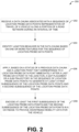
- the computer-implemented method includes applying, based on a status of a previous data chunk and a junction point that corresponds to a location probe data point immediately after a last probe data point in the junction, a gap placement or a sub-trajectory in the sequence of location probe data points to generate at least a first subsequence of the location probe data points and a second subsequence of the location probe data points.
- the computer-implemented method includes encoding at least the first subsequence of the location probe data points and the second subsequence of the location probe data points in a database to provide anonymized mobility data for the vehicle.
- the computer-executable program code instructions are also configured to apply the one or more data features to a machine learning model configured to classify a portion of the sequence of location probe data points as the junction behavior. In one or more embodiments, the computer-executable program code instructions are also configured to train the machine learning model based on a set of labels associated with junction probe data points and non-junction probe data points.
- the computer-executable program code instructions are also configured to identify a first portion in the sequence of location probe data points as a potential origin location of the vehicle during a journey associated with the travel of the vehicle along the portion of the road network. In one or more embodiments, the computer-executable program code instructions are also configured to identify the junction behavior in the first portion in the sequence of location probe data points based on the one or more features for the sequence of location probe data points. In one or more embodiments, the computer-executable program code instructions are also configured to apply the gap placement in the first portion in the sequence of location probe data points.
- the computer program code instructions are also configured to, when executed by the processing circuitry, cause the apparatus to apply, based on a status of a previous data chunk and a junction point that corresponds to a location probe data point immediately after a last probe data point in the junction, a gap placement or a sub-trajectory in the sequence of location probe data points to generate at least a first subsequence of the location probe data points and a second subsequence of the location probe data points.
- at least the first subsequence of the location probe data points and the second subsequence of the location probe data points correspond to anonymized mobility data for the vehicle associated with the road network.
- the computer program code instructions are also configured to, when executed by the processing circuitry, cause the apparatus to cause transmission of the anonymized mobility data to a server computing device.
- the computer program code instructions are configured to, when executed by the processing circuitry, cause the apparatus to apply the gap placement in the sequence of location probe data points based on a set of anonymization parameters associated with a size for gap placements or a size for sub-trajectories.
- the computer-implemented method includes applying, based on a status of a previous data chunk and a junction point that corresponds to a location probe data point immediately after a last probe data point in the junction, a gap placement or a sub-trajectory in the sequence of location probe data points to generate at least a first subsequence of the location probe data points and a second subsequence of the location probe data points.
- at least the first subsequence of the location probe data points and the second subsequence of the location probe data points correspond to anonymized mobility data for the vehicle associated with the road network.
- the computer-implemented method includes causing transmission of the anonymized mobility data to a server computing device.
- the computer-implemented method also includes determining whether to apply the gap placement or the sub-trajectory in the sequence of location probe data points based on a last probe data point in the previous data chunk.
- the computer-implemented method also includes applying the gap placement in the sequence of location probe data points based on a set of anonymization parameters associated with a size for gap placements or a size for sub-trajectories.
- a computer program product in another example embodiment, includes at least one non-transitory computer readable storage medium having computer-executable program code instructions stored therein with the computer-executable program code instructions including program code instructions configured, upon execution, to determine a data chunk associated with a sequence of location probe data points representative of travel of a vehicle along a portion of a road network during an interval of time.
- the computer-executable program code instructions are also configured to identify junction behavior in the data chunk based on one or more features for the sequence of location probe data points.
- the computer-executable program code instructions are also configured to determine whether to apply the gap placement or the sub-trajectory in the sequence of location probe data points based on a last probe data point in the previous data chunk.
- the computer-executable program code instructions are also configured to apply the gap placement in the sequence of location probe data points based on a set of anonymization parameters associated with a size for gap placements or a size for sub-trajectories.
- At least the first subsequence of the location probe data points and the second subsequence of the location probe data points correspond to anonymized mobility data for the vehicle associated with the road network.
- the apparatus of this example embodiment also comprises means for causing transmission of the anonymized mobility data to a server computing device.
- the apparatus of this example embodiment also comprises means for determining whether to apply the gap placement or the sub-trajectory in the sequence of location probe data points based on a last probe data point in the previous data chunk.
- the apparatus of this example embodiment also comprises means for applying the gap placement in the sequence of location probe data points based on a set of anonymization parameters associated with a size for gap placements or a size for sub-trajectories.
- Location-based services for technologies such as, for example, autonomous vehicle navigation, vehicle fleet management, real-time traffic applications, etc. benefit from mobility data collected from vehicles or mobile device in a geographical area.
- the quality of the mobility data is associated with an accuracy value and a privacy value.
- the accuracy value is generally related to the intrinsic utility of the mobility data towards generation of a particular location-based service.
- the privacy value generally reflects the sensitive information that the mobility data reveals about a respective user's habits, behaviors and/or personal information, such as, for example, the user's home address.
- the privacy value also generally reflects risk of the mobility data being related to an inadvertent disclosure or misuse of the mobility data.
- a privacy-enhancing algorithm can be applied to the mobility data.
- Privacy-enhancing algorithms generally function by removing or altering privacy-revealing features of the mobility data.
- traditional privacy-enhancing algorithms often render the mobility data less accurate and therefore less valuable for location-based services and/or related technologies.
- Mobility data may be defined as a set of probe data points (e.g., location probe data points) related to geospatial observations, each of which includes at least a latitude, and/or longitude location. Additional information may be associated with the probe data points, such as, for example, speed, acceleration, heading, a timestamp, and/or other data.
- the mobility data can include additional data derived from a sequence of probe data points such as, for example, a time-windowed headings difference between probe data points computed by a mobile device and/or augmented to a probe data point tuple.
- a trajectory can include a set of probe data points, where probe data points of a trajectory may include a trajectory identifier that associates the probe data points of the trajectory with one another.
- Mobility data captured in trajectories can be partitioned in a set of trajectories (e.g., trajectory data), each of which identifies the movement of a vehicle or mobile device over time.
- a trajectory can correspond to a portion of a road network or other path.
- a model can be trained to predict whether a probe data point is a first point of a trajectory after a junction.
- the model can provide the prediction regarding a probe data point (e.g., whether a probe data point is a first point of a trajectory after a junction) based on one or more features associated with the trajectory and/or the junction.
- the one or more features associated with the trajectory and/or junction can include, but is not limited to, a time-windowed headings difference between probe data points along the trajectory, a speed of one or more probe data points, acceleration of a vehicle or mobile device at one or more probe data points, time data indicative of a duration of time for a turn maneuver related to a vehicle or mobile device at a potential junction, latitude data related to a vehicle or mobile device at one or more probe data points, longitude data related to a vehicle or mobile device at one or more probe data points, timestamp data related to capture of one or more probe data points, heading data indicative of a direction of travel associated with a vehicle or mobile device at one or more probe data points, sensor data associated with a vehicle or mobile device, predetermined map data associated with one or more probe data points, and/or another feature associated with a trajectory.
- the one or more features can be weighted based on road network characteristics, a sampling rate for the mobility data, and/or other criteria associated with the trajectory.
- the model can be a machine learning model such as, for example, a classification model, a decision tree model, or another type of machine learning model that takes into account similar features amongst the mobility data.
- a model configured as a machine learning model can be trained based on labels associated with junction probe data points and non-junction probe data points such that the machine learning model can learn combinations of probe data points that correspond to a junction.
- the model can alternatively be another type of model such as, for example, a deterministic model.
- a model configured as a deterministic model can apply a set of rules to classify a portion a trajectory that corresponds to a junction.
- the model can be deployed (e.g., via a junction detection mode) to determine a probability of respective probe data points from a set of probe data points corresponding to a junction.
- configuration of a trajectory and/or a sub-trajectory can be optimally configured. For example, one or more portions of a trajectory and/or a sub-trajectory can be optimally removed from a trajectory and/or a sub-trajectory to further improve anonymization of mobility data.
- a first set of probe data points at a beginning of a trajectory can be removed (e.g., a start of a trajectory can be cropped) and/or a second set of probe data points at an ending of a trajectory can be removed (e.g., an end of a trajectory can be cropped) to further improve anonymization of mobility data.
- a first set of probe data points at a beginning of a sub-trajectory can be removed (e.g., a start of a sub-trajectory can be cropped) and/or a second set of probe data points at an ending of a sub-trajectory can be removed (e.g., an end of a sub-trajectory can be cropped) to further improve anonymization of mobility data.
- the anonymized mobility data can be published as a content product. For example, completion of anonymization of the mobility data can trigger publication of the anonymized mobility data as a content product.
- the anonymized mobility data may additionally facilitate improved navigation of a vehicle, improved route guidance for a vehicle, improved semi-autonomous vehicle control, and/or improved fully autonomous vehicle control.
- autonomous driving has become a focus of recent technology with recent advances in machine learning, computer vision, and computing power able to conduct real-time mapping and sensing of a vehicle's environment.
- real-time or near real-time sensing of the environment can provide information about potential obstacles, the behavior of others on the roadway, and areas that are navigable by the vehicle.
- An understanding of the location of other vehicles and/or what the other vehicles have done and may be predicted to do may be useful for a vehicle to safely plan a route.
- various embodiments described herein can employ sensors to collect probe data points to identify a location of vehicles along a road network which can provide vehicle localization to enhance location data, navigation, and/or traffic predictions for vehicles.
- the apparatus 102 can be embodied by any of a wide variety of computing devices including, for example, a computer system of a vehicle, a vehicle system of a vehicle, a navigation system of a vehicle, a control system of a vehicle, an electronic control unit of a vehicle, an autonomous vehicle control system (e.g., an autonomous-driving control system) of a vehicle, a mapping system of a vehicle, an Advanced Driver Assistance System (ADAS) module of a vehicle, or any other type of computing device carried by or remote from the vehicle including, for example, a server or a distributed network of computing devices.
- a computer system of a vehicle e.g., a vehicle system of a vehicle, a navigation system of a vehicle, a control system of a vehicle, an electronic control unit of a vehicle, an autonomous vehicle control system (e.g., an autonomous-driving control system) of a vehicle, a mapping system of a vehicle, an Advanced Driver Assistance System (ADAS) module of a vehicle, or any other type
- the apparatus 102 can be embodied or partially embodied by a computing device of a vehicle that supports safety-critical systems such as the powertrain (engine, transmission, electric drive motors, etc.), steering (e.g., steering assist or steer-by-wire), and/or braking (e.g., brake assist or brake-by-wire).
- the computing device may be a fixed computing device, such as a built-in vehicular navigation device, assisted driving device, or the like.
- the processing circuitry 106 (and/or co-processors or any other processors assisting or otherwise associated with the processing circuitry 106) can be in communication with the memory 108 via a bus for passing information among components of the apparatus 102.
- the memory 108 can be non-transitory and can include, for example, one or more volatile and/or non-volatile memories.
- the memory 108 may be an electronic storage device (for example, a computer readable storage medium) comprising gates configured to store data (for example, bits) that can be retrievable by a machine (for example, a computing device like the processing circuitry 106).
- the processing circuitry 106 can be embodied in a number of different ways.
- the processing circuitry 106 may be embodied as one or more of various hardware processing means such as a processor, a coprocessor, a microprocessor, a controller, a digital signal processor (DSP), a processing element with or without an accompanying DSP, or various other processing circuitry including integrated circuits such as, for example, an ASIC (application specific integrated circuit), an FPGA (field programmable gate array), a microcontroller unit (MCU), a hardware accelerator, a special-purpose computer chip, or the like.
- the processing circuitry 106 can include one or more processing cores configured to perform independently.
- a multi-core processor can enable multiprocessing within a single physical package.
- the processing circuitry 106 can include one or more processors configured in tandem via the bus to enable independent execution of instructions, pipelining and/or multithreading.
- the processing circuitry 106 when the processing circuitry 106 is embodied as an executor of software instructions, the instructions can specifically configure the processing circuitry 106 to perform the algorithms and/or operations described herein when the instructions are executed.
- the processing circuitry 106 can be a processor of a specific device (for example, a computing device) configured to employ an embodiment of the present disclosure by further configuration of the processor by instructions for performing the algorithms and/or operations described herein.
- the processing circuitry 106 can include, among other things, a clock, an arithmetic logic unit (ALU) and/or one or more logic gates configured to support operation of the processing circuitry 106.
- ALU arithmetic logic unit
- the apparatus 102 of an example embodiment can also optionally include the communication interface 110 that can be any means such as a device or circuitry embodied in either hardware or a combination of hardware and software that is configured to receive and/or transmit data from/to other electronic devices in communication with the apparatus 102, such as the probe database 104 that stores data (e.g., probe data, location probe data points, geo-referenced locations, global navigation satellite system (GNSS) probe data, global positioning system (GPS) probe data, Galileo probe data, GLONASS probe data, BeiDou probe data, etc.) generated and/or employed by the processing circuitry 106.
- data e.g., probe data, location probe data points, geo-referenced locations, global navigation satellite system (GNSS) probe data, global positioning system (GPS) probe data, Galileo probe data, GLONASS probe data, BeiDou probe data, etc.
- the communication interface 110 can be configured to communicate in accordance with various wireless protocols including, but not limited to, fourth-generation (4G), fifth-generation (5G), sixth-generation (6G), Global System for Mobile Communications (GSM), Long Term Evolution (LTE), etc.
- the communication interface 110 can include, for example, an antenna (or multiple antennas) and supporting hardware and/or software for enabling communications with a wireless communication network.
- the communication interface 110 can include, for example, an antenna (or multiple antennas) and supporting hardware and/or software for enabling communications with a wireless communication network.
- the communication interface 110 can include the circuitry for interacting with the antenna(s) to cause transmission of signals via the antenna(s) or to handle receipt of signals received via the antenna(s).
- the communication interface 110 can alternatively or also support wired communication and/or may alternatively support vehicle to vehicle or vehicle to infrastructure wireless links.
- the apparatus 102 can also optionally include or otherwise be in communication with a user interface 112.
- the user interface 112 can include a display, a touch screen display, a keyboard, a mouse, a joystick, speakers or other input/output mechanisms.
- the processing circuitry 106 can comprise user interface circuitry configured to control at least some functions of one or more input/output mechanisms of the user interface 112.
- the processing circuitry 106 can be configured to control one or more functions of one or more input/output mechanisms of the user interface 112 through computer program instructions (e.g., software and/or firmware) stored on a memory (e.g., the memory 108 and/or the like) accessible to the processing circuitry 106.
- the apparatus 102 can be in communication with one or more sensors 114, such as one or more GNSS sensors, one or more GPS sensors, one or more Galileo sensors, one or more GLONASS sensors, one or more BeiDou sensors, one or more accelerometer sensors, one or more LiDAR sensors, one or more radar sensors, one or more gyroscope sensors, and/or one or more other sensors. Any of the one or more sensors 114 may be used to sense information regarding movement, positioning, and/or orientation of a vehicle for use in navigation assistance and/or autonomous vehicle control, as described herein according to example embodiments.
- sensors 114 such as one or more GNSS sensors, one or more GPS sensors, one or more Galileo sensors, one or more GLONASS sensors, one or more BeiDou sensors, one or more accelerometer sensors, one or more LiDAR sensors, one or more radar sensors, one or more gyroscope sensors, and/or one or more other sensors. Any of the one or more sensors 114 may be used to sense information regarding movement, positioning
- the apparatus 102 includes means, such as the processing circuitry 106, the memory 108, or the like, configured to receive a data chunk associated with a sequence of location probe data points representative of travel of a vehicle along a portion of a road network during an interval of time.
- the data chunk can be a data structure that comprises the sequence of location probe data points.
- the location probe data points can be captured via the one or more sensors 114.
- the location probe data points can be captured via one or more GNSS sensors (e.g., one or more GPS sensors, one or more Galileo sensors, one or more GLONASS sensors, one or more BeiDou sensors, etc.) associated with the vehicle traveling along the road network.
- the location probe data points can be captured via respective navigation systems and/or respective location tracking systems associated with the vehicle.
- the one or more sensors 114 can be carried by the vehicle, for example, as the vehicles travel along the road network (e.g., as the vehicles travel along a road segment of the road network).
- At least a portion of the location probe data points can be stored locally by a memory (e.g., the memory 108) or the like accessible by the processing circuitry 106. Additionally or alternatively, at least a portion of the location data probe points can be stored remotely by cloud storage, a remote server, a remote database or the like accessible by the processing circuitry 106. For instance, in an embodiment, at least a portion of the location data probe points can be stored in the probe database 104.
- the apparatus 102 can be configured to communicate with the vehicle 302 and/or one or more other vehicles via a network 306.
- the network 306 can be one or more wireless networks and/or one or more wired networks such as, for example, a wired or wireless Personal Area Network (PAN), Local Area Network (LAN), Metropolitan Area Network (MAN), Wide Area Network (WAN), cellular network, and/or the like.
- the network 306 can include an automotive cloud, a digital transportation infrastructure (DTI), a radio data system (RDS), a high definition (HD) radio, another digital radio system, and/or the like.
- DTI digital transportation infrastructure
- RDS radio data system
- HD high definition
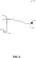
- the scenario 400 as illustrated includes a sequence of location probe data points 402a-n that represent travel of the vehicle 302 along a road network.
- the sequence of location probe data points 402a-n can correspond to a trajectory.
- the road network can be defined by a starting location 404 and an ending location 406.
- the road network can also include a junction 408 between the starting location 404 and the ending location 406.
- the sequence of location probe data points 402a-n can also correspond to mobility data captured by the vehicle 302.
- the sequence of location probe data points 402a-n can represent a non-anonymized trajectory.
- the apparatus 102 can be configured to determine whether to apply the gap placement or the sub-trajectory in the sequence of location probe data points based on a last probe data point in the previous data chunk.
- the apparatus 102 can be configured to apply the gap placement in the sequence of location probe data points based on a set of anonymization parameters associated with a size for gap placements.
- the set of anonymization parameters associated with a size for gap placements can be related to a minimum gap size and/or a maximum gap size.
- one or more other sequences of location probe data points received by the apparatus 102 can be tuned based on predetermined targets of the proportions of junctions and/or a probability to keep or remove a junction. In certain embodiments, the probability can additionally or alternatively be tuned.
- the apparatus 102 such as the processing circuitry 106, can be configured to cause transmission of the first subsequence of the location probe data points and/or the second subsequence of the location probe data points to a server computing device (e.g., the map data service provider 1008) associated with a location-based service, a traffic service, a mapping service, another type of service, etc.
- a server computing device e.g., the map data service provider 1008 associated with a location-based service, a traffic service, a mapping service, another type of service, etc.
- the map database 1010 can include data about places, such as cities, towns, or other communities, and other geographic features such as bodies of water, mountain ranges, etc. Such place or feature data can be part of the POI data or can be associated with POIs or POI data records (such as a data point used for displaying or representing a position of a city).
- the map database 1010 can include event data (e.g., traffic incidents, construction activities, scheduled events, unscheduled events, etc.) associated with the POI data records or other records of the map database 1010.
- remote sensing such as aerial or satellite photography and/or LiDAR
- vehicle data provided by vehicles, such as provided, e.g., as probe points, by mobile device 1004, as they travel the roads throughout a region.
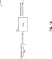
- one or more data features 1206 associated with the sequence of location probe data points 1204 can be applied to the model 1202 (e.g., the model 1202 configured as a machine learning model) to classify a portion of the sequence of location probe data points 1204 as a junction behavior classification 1208.
- labeled examples of junctions employed as training data for the model 1202 can be obtained by map-matching probe data points to corresponding locations of known junctions and/or verified junctions of the map database 1010.
Landscapes
- Engineering & Computer Science (AREA)
- Radar, Positioning & Navigation (AREA)
- Remote Sensing (AREA)
- Physics & Mathematics (AREA)
- General Physics & Mathematics (AREA)
- Automation & Control Theory (AREA)
- Theoretical Computer Science (AREA)
- General Health & Medical Sciences (AREA)
- Health & Medical Sciences (AREA)
- Bioethics (AREA)
- Databases & Information Systems (AREA)
- Computer Security & Cryptography (AREA)
- Software Systems (AREA)
- Computer Hardware Design (AREA)
- General Engineering & Computer Science (AREA)
- Medical Informatics (AREA)
- Computer Networks & Wireless Communication (AREA)
- Signal Processing (AREA)
- Chemical & Material Sciences (AREA)
- Analytical Chemistry (AREA)
- Traffic Control Systems (AREA)
Applications Claiming Priority (1)
| Application Number | Priority Date | Filing Date | Title |
|---|---|---|---|
| US18/059,273 US20240175703A1 (en) | 2022-11-28 | 2022-11-28 | Method, apparatus, and computer program product for at least approximate real-time intelligent gap placement within mobility data using junctions inferred by features of the mobility data |
Publications (1)
| Publication Number | Publication Date |
|---|---|
| EP4394323A1 true EP4394323A1 (de) | 2024-07-03 |
Family
ID=88975544
Family Applications (1)
| Application Number | Title | Priority Date | Filing Date |
|---|---|---|---|
| EP23212394.3A Pending EP4394323A1 (de) | 2022-11-28 | 2023-11-27 | Verfahren, vorrichtung und computerprogrammprodukt zur mindestens ungefähren intelligenten echtzeitlückenplatzierung in mobilitätsdaten mit anhand von merkmalen der mobilitätsdaten abgeleiteten übergängen |
Country Status (2)
| Country | Link |
|---|---|
| US (1) | US20240175703A1 (de) |
| EP (1) | EP4394323A1 (de) |
Citations (3)
| Publication number | Priority date | Publication date | Assignee | Title |
|---|---|---|---|---|
| US20190373403A1 (en) * | 2018-04-27 | 2019-12-05 | Here Global B.V. | Dynamic mix zones |
| US20220026225A1 (en) * | 2020-07-22 | 2022-01-27 | Here Global B.V. | Method, apparatus, and computer program product for anonymizing trajectories |
| US20220136841A1 (en) * | 2020-11-03 | 2022-05-05 | Here Global B.V. | Method, apparatus, and computer program product for anonymizing trajectories |
-
2022
- 2022-11-28 US US18/059,273 patent/US20240175703A1/en active Pending
-
2023
- 2023-11-27 EP EP23212394.3A patent/EP4394323A1/de active Pending
Patent Citations (3)
| Publication number | Priority date | Publication date | Assignee | Title |
|---|---|---|---|---|
| US20190373403A1 (en) * | 2018-04-27 | 2019-12-05 | Here Global B.V. | Dynamic mix zones |
| US20220026225A1 (en) * | 2020-07-22 | 2022-01-27 | Here Global B.V. | Method, apparatus, and computer program product for anonymizing trajectories |
| US20220136841A1 (en) * | 2020-11-03 | 2022-05-05 | Here Global B.V. | Method, apparatus, and computer program product for anonymizing trajectories |
Non-Patent Citations (2)
| Title |
|---|
| ALIREZA FATHI ET AL: "Detecting Road Intersections from GPS Traces", 14 September 2010, GEOGRAPHIC INFORMATION SCIENCE, SPRINGER BERLIN HEIDELBERG, BERLIN, HEIDELBERG, PAGE(S) 56 - 69, ISBN: 978-3-642-15299-3, XP019149355 * |
| ZUBERI RUBINA SHAHIN ET AL: "DETECTION OF ROAD INTERSECTIONS USING HISTORY TRAJECTORY DATA FOR EVOLVING MIX-ZONES", INTERNATIONAL JOURNAL ON ADVANCED COMPUTER THEORY AND ENGINEERING (IJACTE), vol. 3, no. 1, 1 January 2014 (2014-01-01), pages 28 - 32, XP093150107, ISSN: 2319-2526, Retrieved from the Internet <URL:http://www.irdindia.in/journal_ijacte/pdf/vol3_iss1/5.pdf> [retrieved on 20240410] * |
Also Published As
| Publication number | Publication date |
|---|---|
| US20240175703A1 (en) | 2024-05-30 |
Similar Documents
| Publication | Publication Date | Title |
|---|---|---|
| US10928819B2 (en) | Method and apparatus for comparing relevant information between sensor measurements | |
| EP4300336B1 (de) | Verfahren, vorrichtung und computerprogrammprodukt zur schätzung des datenschutzrisikos von anonymisierten bahndaten | |
| US11193789B2 (en) | Method, apparatus, and computer program product for identifying at-risk road infrastructure | |
| EP3992828B1 (de) | Verfahren, vorrichtung und computerprogrammprodukt zur anonymisierung von trajektorien | |
| US20220063639A1 (en) | Method, apparatus, and computer program product for predicting autonomous transition regions using historical information | |
| US20220137641A1 (en) | Method, apparatus, and computer program product for generating an autonomous driving profile map index | |
| US11914747B2 (en) | Method, apparatus, and computer program product for quantifying the linkability of trajectory data | |
| US10899348B2 (en) | Method, apparatus and computer program product for associating map objects with road links | |
| EP3961154A1 (de) | Verfahren, vorrichtung und computerprogrammprodukt zur erzeugung eines automatisierten fahrfähigkeitskartenindex | |
| EP4002763A1 (de) | Verfahren, vorrichtung und computerprogrammprodukt zur identifizierung von datenschutzrisiken in datensätzen | |
| US12507035B2 (en) | Method, apparatus, and computer program product for anonymizing trajectories and stay points | |
| US12282846B2 (en) | Method, apparatus, and computer program product for surveillance of road environments via deep learning | |
| EP4099725B1 (de) | Verfahren, gerät und computerprogrammprodukt zum anonymisieren von bahnverläufen und aufenthaltspunkten | |
| US20230135578A1 (en) | Method and apparatus for generating structured trajectories from geospatial observations | |
| US20230137263A1 (en) | Method and apparatus for generating structured trajectories from geospatial observations | |
| US11713979B2 (en) | Method, apparatus, and computer program product for generating a transition variability index related to autonomous driving | |
| US20240375678A1 (en) | Method, apparatus, and computer program product for generating speed profiles for autonomous vehicles in safety risk situations for a road segment | |
| EP4382865A1 (de) | Verfahren, vorrichtung und computerprogrammprodukt für intelligente trajektorienkonfigurationen in mobilitätsdaten unter verwendung von durch merkmale der mobilitätsdaten abgeleiteten übergängen | |
| US11687094B2 (en) | Method, apparatus, and computer program product for organizing autonomous vehicles in an autonomous transition region | |
| US12205047B2 (en) | Method, apparatus, and computer program product for anonymized parking likelihood estimation | |
| US20240378998A1 (en) | Method, apparatus, and computer program product for defining a geo-defense area related to presence of a roadworker entity | |
| EP4093063B1 (de) | Verfahren, vorrichtung und computerprogrammprodukt zur quantifizierung des datenschutzrisikos von trajektoriedaten | |
| EP4375620A1 (de) | Verfahren, vorrichtung und computerprogrammprodukt zur intelligenten lückenplatzierung in mobilitätsdaten unter verwendung von durch merkmale der mobilitätsdaten abgeleiteten übergängen | |
| US20240175703A1 (en) | Method, apparatus, and computer program product for at least approximate real-time intelligent gap placement within mobility data using junctions inferred by features of the mobility data | |
| US12604182B2 (en) | Method and apparatus for generating sub-trajectories for a trajectory |
Legal Events
| Date | Code | Title | Description |
|---|---|---|---|
| PUAI | Public reference made under article 153(3) epc to a published international application that has entered the european phase |
Free format text: ORIGINAL CODE: 0009012 |
|
| STAA | Information on the status of an ep patent application or granted ep patent |
Free format text: STATUS: THE APPLICATION HAS BEEN PUBLISHED |
|
| AK | Designated contracting states |
Kind code of ref document: A1 Designated state(s): AL AT BE BG CH CY CZ DE DK EE ES FI FR GB GR HR HU IE IS IT LI LT LU LV MC ME MK MT NL NO PL PT RO RS SE SI SK SM TR |
|
| P01 | Opt-out of the competence of the unified patent court (upc) registered |
Free format text: CASE NUMBER: APP_52427/2024 Effective date: 20240918 |
|
| STAA | Information on the status of an ep patent application or granted ep patent |
Free format text: STATUS: REQUEST FOR EXAMINATION WAS MADE |
|
| 17P | Request for examination filed |
Effective date: 20241219 |