EP4394448A1 - Atténuation de trajets multiples pour détermination de localisation gnss à l'aide de deux antennes - Google Patents
Atténuation de trajets multiples pour détermination de localisation gnss à l'aide de deux antennes Download PDFInfo
- Publication number
- EP4394448A1 EP4394448A1 EP23217758.4A EP23217758A EP4394448A1 EP 4394448 A1 EP4394448 A1 EP 4394448A1 EP 23217758 A EP23217758 A EP 23217758A EP 4394448 A1 EP4394448 A1 EP 4394448A1
- Authority
- EP
- European Patent Office
- Prior art keywords
- antenna
- gnss
- sdcp
- observables
- weight
- Prior art date
- Legal status (The legal status is an assumption and is not a legal conclusion. Google has not performed a legal analysis and makes no representation as to the accuracy of the status listed.)
- Pending
Links
Images




Classifications
-
- G—PHYSICS
- G01—MEASURING; TESTING
- G01S—RADIO DIRECTION-FINDING; RADIO NAVIGATION; DETERMINING DISTANCE OR VELOCITY BY USE OF RADIO WAVES; LOCATING OR PRESENCE-DETECTING BY USE OF THE REFLECTION OR RERADIATION OF RADIO WAVES; ANALOGOUS ARRANGEMENTS USING OTHER WAVES
- G01S19/00—Satellite radio beacon positioning systems; Determining position, velocity or attitude using signals transmitted by such systems
- G01S19/01—Satellite radio beacon positioning systems transmitting time-stamped messages, e.g. GPS [Global Positioning System], GLONASS [Global Orbiting Navigation Satellite System] or GALILEO
- G01S19/13—Receivers
- G01S19/22—Multipath-related issues
-
- G—PHYSICS
- G01—MEASURING; TESTING
- G01S—RADIO DIRECTION-FINDING; RADIO NAVIGATION; DETERMINING DISTANCE OR VELOCITY BY USE OF RADIO WAVES; LOCATING OR PRESENCE-DETECTING BY USE OF THE REFLECTION OR RERADIATION OF RADIO WAVES; ANALOGOUS ARRANGEMENTS USING OTHER WAVES
- G01S19/00—Satellite radio beacon positioning systems; Determining position, velocity or attitude using signals transmitted by such systems
- G01S19/01—Satellite radio beacon positioning systems transmitting time-stamped messages, e.g. GPS [Global Positioning System], GLONASS [Global Orbiting Navigation Satellite System] or GALILEO
- G01S19/13—Receivers
- G01S19/32—Multimode operation in a single same satellite system, e.g. GPS L1/L2
-
- G—PHYSICS
- G01—MEASURING; TESTING
- G01S—RADIO DIRECTION-FINDING; RADIO NAVIGATION; DETERMINING DISTANCE OR VELOCITY BY USE OF RADIO WAVES; LOCATING OR PRESENCE-DETECTING BY USE OF THE REFLECTION OR RERADIATION OF RADIO WAVES; ANALOGOUS ARRANGEMENTS USING OTHER WAVES
- G01S19/00—Satellite radio beacon positioning systems; Determining position, velocity or attitude using signals transmitted by such systems
- G01S19/01—Satellite radio beacon positioning systems transmitting time-stamped messages, e.g. GPS [Global Positioning System], GLONASS [Global Orbiting Navigation Satellite System] or GALILEO
- G01S19/13—Receivers
- G01S19/35—Constructional details or hardware or software details of the signal processing chain
- G01S19/36—Constructional details or hardware or software details of the signal processing chain relating to the receiver frond end
-
- G—PHYSICS
- G01—MEASURING; TESTING
- G01S—RADIO DIRECTION-FINDING; RADIO NAVIGATION; DETERMINING DISTANCE OR VELOCITY BY USE OF RADIO WAVES; LOCATING OR PRESENCE-DETECTING BY USE OF THE REFLECTION OR RERADIATION OF RADIO WAVES; ANALOGOUS ARRANGEMENTS USING OTHER WAVES
- G01S19/00—Satellite radio beacon positioning systems; Determining position, velocity or attitude using signals transmitted by such systems
- G01S19/38—Determining a navigation solution using signals transmitted by a satellite radio beacon positioning system
- G01S19/39—Determining a navigation solution using signals transmitted by a satellite radio beacon positioning system the satellite radio beacon positioning system transmitting time-stamped messages, e.g. GPS [Global Positioning System], GLONASS [Global Orbiting Navigation Satellite System] or GALILEO
- G01S19/42—Determining position
- G01S19/43—Determining position using carrier phase measurements, e.g. kinematic positioning; using long or short baseline interferometry
Definitions
- GNSS Global navigation satellite systems
- GPS Global Positioning System
- GLONASS Global Positioning System
- Galileo operated by the European Space Agency
- BeiDou BeiDou
- Each satellite emits signals that include satellite identifiers, ephemeris data (indicative of the location and health of the satellite), and timestamps.
- a GNSS receiver unit can receive signals from multiple satellites in one or more constellations and use the timestamps to determine the propagation delay time from the satellite to the receiver.
- Location determination using GNSS is subject to various sources of error, including variable delays in the ionosphere and/or troposphere, clock synchronization errors, ephemeris errors, and multipath errors (where the signal may not take a direct path to the receiver). Accuracy of location determination using GNSS triangulation techniques is often limited to a few meters under open sky conditions and becomes worse under limited-view conditions.
- RTK real-time kinematic positioning
- RTK uses phase tracking of the GNSS carrier wave in addition to the information content of the signal to enhance location accuracy.
- RTK generally requires two receivers: a "base” unit located at a fixed position and a “rover” unit, each of which has a GNSS receiver system that is capable of determining the phase of the carrier wave in addition to the information content of the signal.
- the base unit is placed in an open area with a clear view of the sky and remains stationary, allowing a location fix to be determined and maintained.
- the rover unit is moved about the survey site to determine locations of various points of interest.
- the base unit transmits its observed carrier phase information to the rover unit, and the rover unit can use this additional input in generating its own location estimates.
- RTK can achieve location accuracy on the order of 1 cm under favorable conditions.
- Precise point positioning (PPP) is another technique that uses carrier phase in addition to the information content of the signal in determining a location. Unlike RTK, PPP does not require a base unit, but centimeter-level accuracy may require that the receiver remain stationary for a sufficient period of time, which can be on the order of minutes.
- a "geometry-free" SDCP can be computed, e.g., by subtracting SDCPs determined for different frequencies.
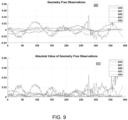
- the geometry-free SDCP can provide an estimate of the degree to which the observations are affected by multipath.
- the degree of multipath effect estimated from a given SDCP (including a geometry-free SDCP) can be used to assign a weight to the corresponding observations, with observations having a higher degree of multipath effect being assigned lower weight (or discarded entirely).
- the weights assigned to different observations can be used when determining location of one (or both) of the antennas using signals from multiple GNSS satellites, thereby providing mitigation of multipath errors.
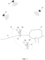
- Some embodiments relate to methods of determining location of a receiver system having a first antenna and a second antenna mounted on a movable structure in fixed locations relative to each other and defining a baseline.
- the first antenna and the second antenna can receive global navigation satellite system (GNSS) signals from a plurality of GNSS satellites.
- GNSS global navigation satellite system
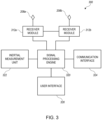
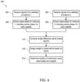
- the receiver system can: extract a first set of observables from the GNSS signal as received by the first antenna, the first set of observables including a first carrier phase; extract a second set of observables from the GNSS signal as received by the second antenna, the second set of observables including a second carrier phase; and compute a single difference carrier phase (SDCP) between the first carrier phase and the second carrier phase.
- SDCP single difference carrier phase
- the receiver system can assign a weight for each GNSS satellite based at least in part on the SDCP computed for each received GNSS signal and can determine a location of the receiver system using the first and second sets of observables extracted from the received GNSS signals and the weights.
- the receiver circuitry can be configured to extract a third set of observables from a second GNSS signal from the first one of the GNSS satellites as received by the first antenna and a fourth set of observables from the second GNSS signal as received by the second antenna, wherein the second GNSS signal has a frequency different from a frequency of the first GNSS signal, wherein the third set of observables includes a third carrier phase and the fourth set of observables includes a fourth carrier phase.
- a given GNSS receiver system may be configured to detect and process signals from any or all of these or other GNSS satellites and may use conventional or other techniques to extract a location measurement from received satellite signals based on code phase and other data encoded in the signal (e.g., ephemeris data indicating satellite locations); other information such as carrier phase, Doppler shift, and the like may also be exploited.
- code phase and other data encoded in the signal e.g., ephemeris data indicating satellite locations
- other information such as carrier phase, Doppler shift, and the like may also be exploited.
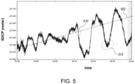
- ⁇ ⁇ is removed, remaining variation between data points is assumed to be dominated by multipath effect ⁇ m f 1,2 .
- the multipath effect is highly variable. For instance, in region 510, ⁇ m f 1,2 is small, while in region 512, ⁇ m f 1,2 is significantly larger. This is due to movement of the satellite across the sky relative to the antenna; the signal paths from the same satellite at different times may encounter different obstacles (or no obstacles).
- ⁇ ⁇ between antenna 1 and antenna 2 can be estimated by performing an RTK computation between antenna 1 and antenna 2, using one of the antennas as the "base” and the other as the “rover.”
- RTK uses the SDCP between the two antennas and uses a priori estimates of the variance or standard deviation of each antenna to assign weights to observations from different satellites. These a priori estimates can be a function of signal-to-noise ratio, satellite elevation angle, and a calibrated model of antenna behavior; conventional or other techniques can be used.
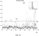
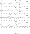
- weights can be assigned based on a geometry-free analysis (e.g., as described below with reference to FIGs. 7-11 ), rather than relying on a priori estimates.
- a location of one or both of the antennas can be determined using the observables and weights for observations of multiple GNSS satellites (at one frequency or multiple frequencies).
- the same observations used to compute SDCP and assign weights can also be used for location determination.
- determining the location of an antenna can include observing multiple GNSS satellites and extracting observables for each satellite, determining a distance to each satellite using the set of observables, and computing a location of the antenna using triangulation of the distances and/or other techniques. All of the observations can be used, with different observations being given different weights.
- the weight for each observation can be the weight assigned at block 416.
- Assignment of weights at block 718 can incorporate this information, e.g., de-weighting the observations from a satellite at a particular frequency (L2 in this example) relative to other observations from the same satellite.
Landscapes
- Engineering & Computer Science (AREA)
- Radar, Positioning & Navigation (AREA)
- Remote Sensing (AREA)
- Computer Networks & Wireless Communication (AREA)
- Physics & Mathematics (AREA)
- General Physics & Mathematics (AREA)
- Signal Processing (AREA)
- Position Fixing By Use Of Radio Waves (AREA)
Applications Claiming Priority (1)
| Application Number | Priority Date | Filing Date | Title |
|---|---|---|---|
| US18/091,675 US20240219581A1 (en) | 2022-12-30 | 2022-12-30 | Multipath mitigation for gnss location determination using dual antennas |
Publications (1)
| Publication Number | Publication Date |
|---|---|
| EP4394448A1 true EP4394448A1 (fr) | 2024-07-03 |
Family
ID=89223695
Family Applications (1)
| Application Number | Title | Priority Date | Filing Date |
|---|---|---|---|
| EP23217758.4A Pending EP4394448A1 (fr) | 2022-12-30 | 2023-12-18 | Atténuation de trajets multiples pour détermination de localisation gnss à l'aide de deux antennes |
Country Status (2)
| Country | Link |
|---|---|
| US (1) | US20240219581A1 (fr) |
| EP (1) | EP4394448A1 (fr) |
Citations (3)
| Publication number | Priority date | Publication date | Assignee | Title |
|---|---|---|---|---|
| US20180284287A1 (en) * | 2017-03-30 | 2018-10-04 | Mitsubishi Electric Research Laboratories, Inc. | Positioning System for Global Navigational Satellite System |
| WO2020041383A1 (fr) * | 2018-08-20 | 2020-02-27 | Hemisphere GNSS, Inc. | Système et procédé de détection de signaux satellitaires de système mondial de navigation par satellite |
| US20210333415A1 (en) * | 2020-04-24 | 2021-10-28 | Honeywell International Inc. | Multiple faulty global navigation satellite system signal detecting system |
Family Cites Families (6)
| Publication number | Priority date | Publication date | Assignee | Title |
|---|---|---|---|---|
| FR2823309B1 (fr) * | 2001-04-06 | 2005-05-06 | Thomson Csf | Recepteur de determination d'orientation d'un mobile |
| US8638257B2 (en) * | 2009-10-15 | 2014-01-28 | Novatel, Inc. | Ultra short baseline GNSS receiver |
| US20110267225A1 (en) * | 2010-04-28 | 2011-11-03 | Liwen Dai | System and method for determining the heading angle of a vehicle |
| US11378697B2 (en) * | 2019-10-30 | 2022-07-05 | Qualcomm Incorporated | Multipath mitigation for multiband GNSS receiver |
| RU2020114350A (ru) * | 2020-04-22 | 2021-10-22 | Тримбл Инк. | Приемник gnss, приспособленный для создания, использования и передачи программно-сформированных данных спутникового сигнала |
| CN111580136B (zh) * | 2020-04-26 | 2022-11-01 | 北京时代民芯科技有限公司 | 一种接收机自主完好性故障检测方法 |
-
2022
- 2022-12-30 US US18/091,675 patent/US20240219581A1/en active Pending
-
2023
- 2023-12-18 EP EP23217758.4A patent/EP4394448A1/fr active Pending
Patent Citations (3)
| Publication number | Priority date | Publication date | Assignee | Title |
|---|---|---|---|---|
| US20180284287A1 (en) * | 2017-03-30 | 2018-10-04 | Mitsubishi Electric Research Laboratories, Inc. | Positioning System for Global Navigational Satellite System |
| WO2020041383A1 (fr) * | 2018-08-20 | 2020-02-27 | Hemisphere GNSS, Inc. | Système et procédé de détection de signaux satellitaires de système mondial de navigation par satellite |
| US20210333415A1 (en) * | 2020-04-24 | 2021-10-28 | Honeywell International Inc. | Multiple faulty global navigation satellite system signal detecting system |
Non-Patent Citations (1)
| Title |
|---|
| MORADI RAMIN ET AL: "Reducing GPS Wide Lane Ambiguity Resolution Time: A Novel Carrier Phase Multipath Mitigation Technique", ITM 2013 - PROCEEDINGS OF THE 2013 INTERNATIONAL TECHNICAL MEETING OF THE INSTITUTE OF NAVIGATION, THE INSTITUTE OF NAVIGATION, 8551 RIXLEW LANE SUITE 360 MANASSAS, VA 20109, USA, 27 January 2013 (2013-01-27), pages 343 - 350, XP056007976 * |
Also Published As
| Publication number | Publication date |
|---|---|
| US20240219581A1 (en) | 2024-07-04 |
Similar Documents
| Publication | Publication Date | Title |
|---|---|---|
| JP7153427B2 (ja) | 衛星測位システムを用いた測位方法および測位装置 | |
| US9538336B2 (en) | Performing data collection based on internal raw observables using a mobile data collection platform | |
| US9544737B2 (en) | Performing data collection based on external raw observables using a mobile data collection platform | |
| US5812961A (en) | Method and reciever using a low earth orbiting satellite signal to augment the global positioning system | |
| US9405012B2 (en) | Advanced global navigation satellite systems (GNSS) positioning using precise satellite information | |
| US10739471B2 (en) | GNSS receiver with a capability to resolve ambiguities using an uncombined formulation | |
| US20070075896A1 (en) | Attitude determination exploiting geometry constraints | |
| CN101680943A (zh) | 实时动态(rtk)定位中距离相关的误差减轻 | |
| US10234565B2 (en) | Global navigation satellite system receiver convergence selection | |
| CA2631479A1 (fr) | Procede pour l'utilisation combinee d'un systeme de positionnement local, d'un systeme local de cinematique en temps reel (rtk) et d'un systeme de positionnement a phase de porteuse regional, longue portee ou mondial | |
| JP7696629B2 (ja) | 拡張リアルタイムキネマティック(rtk) | |
| US12032077B2 (en) | System and method for compensating for scintillation and for facilitation of long-baseline RTK | |
| CN110568464A (zh) | 基于bds/gnss多模芯片的精密定位方法及装置 | |
| Yi | On improving the accuracy and reliability of GPS/INS-based direct sensor georeferencing | |
| Angrisano et al. | Using local redundancy to improve GNSS absolute positioning in harsh scenario | |
| AMAMI | Enhancing Stand-Alone GPS Code Positioning Using Stand-Alone Double Differencing Carrier Phase Relative Positioning | |
| EP4397999A1 (fr) | Détermination de localisation gnss à l'aide d'une antenne virtuelle | |
| US6104339A (en) | All-terrain error correction | |
| EP4394448A1 (fr) | Atténuation de trajets multiples pour détermination de localisation gnss à l'aide de deux antennes | |
| Cheng-wei et al. | Performance analysis of MADOCA-enhanced tightly coupled PPP/IMU | |
| CN111337959A (zh) | 终端的定位方法及装置、定位系统及移动终端 | |
| Althaf et al. | High-accuracy static baseline estimation using NavIC L5 observables | |
| Luo | Mathematical models for GPS positioning | |
| US12618983B2 (en) | Methods and systems for excess path length corrections for GNSS receivers | |
| Ganguly et al. | Space-Borne GPS Receivers for Remote Sensing of the Ionosphere and the Troposphere |
Legal Events
| Date | Code | Title | Description |
|---|---|---|---|
| PUAI | Public reference made under article 153(3) epc to a published international application that has entered the european phase |
Free format text: ORIGINAL CODE: 0009012 |
|
| STAA | Information on the status of an ep patent application or granted ep patent |
Free format text: STATUS: THE APPLICATION HAS BEEN PUBLISHED |
|
| AK | Designated contracting states |
Kind code of ref document: A1 Designated state(s): AL AT BE BG CH CY CZ DE DK EE ES FI FR GB GR HR HU IE IS IT LI LT LU LV MC ME MK MT NL NO PL PT RO RS SE SI SK SM TR |
|
| STAA | Information on the status of an ep patent application or granted ep patent |
Free format text: STATUS: REQUEST FOR EXAMINATION WAS MADE |
|
| 17P | Request for examination filed |
Effective date: 20241218 |