EP4529042A1 - Verfahren zur herstellung einer verbindung zwischen satelliten und kommunikationsvorrichtung - Google Patents
Verfahren zur herstellung einer verbindung zwischen satelliten und kommunikationsvorrichtung Download PDFInfo
- Publication number
- EP4529042A1 EP4529042A1 EP23822932.2A EP23822932A EP4529042A1 EP 4529042 A1 EP4529042 A1 EP 4529042A1 EP 23822932 A EP23822932 A EP 23822932A EP 4529042 A1 EP4529042 A1 EP 4529042A1
- Authority
- EP
- European Patent Office
- Prior art keywords
- satellite
- track
- ground
- address
- inter
- Prior art date
- Legal status (The legal status is an assumption and is not a legal conclusion. Google has not performed a legal analysis and makes no representation as to the accuracy of the status listed.)
- Pending
Links
Images






Classifications
-
- H—ELECTRICITY
- H04—ELECTRIC COMMUNICATION TECHNIQUE
- H04B—TRANSMISSION
- H04B7/00—Radio transmission systems, i.e. using radiation field
- H04B7/14—Relay systems
- H04B7/15—Active relay systems
- H04B7/185—Space-based or airborne stations; Stations for satellite systems
- H04B7/1851—Systems using a satellite or space-based relay
- H04B7/18519—Operations control, administration or maintenance
-
- H—ELECTRICITY
- H04—ELECTRIC COMMUNICATION TECHNIQUE
- H04B—TRANSMISSION
- H04B7/00—Radio transmission systems, i.e. using radiation field
- H04B7/14—Relay systems
- H04B7/15—Active relay systems
- H04B7/185—Space-based or airborne stations; Stations for satellite systems
- H04B7/18521—Systems of inter linked satellites, i.e. inter satellite service
-
- H—ELECTRICITY
- H04—ELECTRIC COMMUNICATION TECHNIQUE
- H04L—TRANSMISSION OF DIGITAL INFORMATION, e.g. TELEGRAPHIC COMMUNICATION
- H04L45/00—Routing or path finding of packets in data switching networks
- H04L45/74—Address processing for routing
-
- H—ELECTRICITY
- H04—ELECTRIC COMMUNICATION TECHNIQUE
- H04W—WIRELESS COMMUNICATION NETWORKS
- H04W40/00—Communication routing or communication path finding
- H04W40/02—Communication route or path selection, e.g. power-based or shortest path routing
- H04W40/20—Communication route or path selection, e.g. power-based or shortest path routing based on geographic position or location
-
- H—ELECTRICITY
- H04—ELECTRIC COMMUNICATION TECHNIQUE
- H04B—TRANSMISSION
- H04B7/00—Radio transmission systems, i.e. using radiation field
- H04B7/14—Relay systems
- H04B7/15—Active relay systems
- H04B7/185—Space-based or airborne stations; Stations for satellite systems
- H04B7/18502—Airborne stations
- H04B7/18504—Aircraft used as relay or high altitude atmospheric platform
-
- H—ELECTRICITY
- H04—ELECTRIC COMMUNICATION TECHNIQUE
- H04B—TRANSMISSION
- H04B7/00—Radio transmission systems, i.e. using radiation field
- H04B7/14—Relay systems
- H04B7/15—Active relay systems
- H04B7/185—Space-based or airborne stations; Stations for satellite systems
- H04B7/1851—Systems using a satellite or space-based relay
Definitions
- Embodiments of this application relate to the field of communication technologies, and in particular, to an inter-satellite link construction method and a communication apparatus.
- 5th generation (5th generation, 5G) new radio new radio (new radio, NR) has entered a commercial deployment phase from a standardization phase.
- An NR standard is researched and designed for a characteristic of terrestrial communication, and has characteristics of providing high-rate, high-reliability, and low-latency communication for a user terminal.
- non-terrestrial network non-terrestrial network, NTN
- NTN non-terrestrial network
- research institutes, communication organizations, companies, and the like have participated in researching NTN communication technologies and standards, aiming to build an integrated communication network for space-air-ground communication.
- a large-scale communication satellite constellation is usually designed by using a Walker (Walker) constellation.
- a constellation consists of several satellites distributed on one or more orbital planes as required. All satellites in a same constellation use circular orbits having a same altitude and a same inclination angle. Orbital planes are evenly distributed along the equator, and the satellites are evenly distributed on the orbits. There is a specific relationship between phases of satellites in different orbital planes. Generally, each satellite may establish an inter-satellite link to a front satellite and a rear satellite on an orbital plane, and may further establish an inter-satellite link to a satellite on an adjacent orbital plane.
- This application provides an inter-satellite link construction method and a communication apparatus, to establish an inter-satellite link in a satellite constellation with discrete orbits.
- this application provides an inter-satellite link construction method.
- the method may be performed by a satellite.
- the satellite may be a geostationary satellite, a non-geostationary satellite, an artificial satellite, a low earth orbit satellite, a medium earth orbit satellite, a high earth orbit satellite, or the like. This is not specifically limited herein in this application.
- the method includes: A first satellite receives an inter-satellite link creation message of a second satellite, where the inter-satellite link creation message includes at least one of the following: an address of the second satellite and a satellite number of the second satellite, and the address of the second satellite is determined based on a projection location of the second satellite on a second ground projected track; and if the second satellite and the first satellite satisfy an inter-satellite link matching rule, the first satellite creates an inter-satellite link between the first satellite and the second satellite, where the inter-satellite link matching rule is determined based on at least one of the following parameters: the address of the second satellite and the satellite number of the second satellite.
- the construction of the inter-satellite link is determined based on an address of the satellite or a satellite number of the satellite, and is irrelevant to an orbit on which the satellite is located.
- the inter-satellite link constructed in this manner can adapt to a requirement of a satellite constellation with discrete orbits.
- the inter-satellite link matching rule includes at least one of the following: the address of the second satellite and an address of the first satellite satisfy a satellite address difference, the satellite number of the second satellite and a satellite number of the first satellite satisfy a satellite number difference, and there is a mapping relationship between a track segment in which the second satellite is located and a track segment in which the first satellite is located; and the address of the first satellite is determined based on a projection location of the first satellite on a first ground projected track.
- an inter-satellite link matching rule may be determined based on the address of the satellite and the number of the satellite, and depending on whether there is a mapping relationship between tracks in which the satellites are located. In this manner, it can be ensured that the satellite can establish an appropriate inter-satellite link, to ensure efficiency of constructing an inter-satellite link between ground co-track satellites.
- the inter-satellite link matching rule is included in the creation message, or is not included in the creation message, but may be transmitted together with the creation message.
- the inter-satellite link matching rule is pre-stored in the first satellite. This manner can reduce signaling overheads.
- the creation message further includes an identifier of the ground projected track of the second satellite.
- the creation message further includes the identifier of the ground projected track of the second satellite, so that the first satellite can simply determine, based on the identifier of the ground projected track of the second satellite, whether the second satellite can construct the inter-satellite link to the first satellite.
- the address of the second satellite is alternatively determined based on the identifier of the second ground projected track.
- the address of the second satellite is determined based on the identifier of the ground projected track of the second satellite, and satellite addressing is performed based on the identifier of the ground projected track of the second satellite, to more quickly construct the inter-satellite link.
- a condition that satisfies the satellite address difference includes: the address of the first satellite and the address of the second satellite are less than a first address threshold.
- a condition that satisfies the satellite address difference includes: a distance between the first satellite and the second satellite is less than a first distance threshold, or a distance between the first satellite and the second satellite is less than a first latitude threshold.
- a condition that satisfies the satellite number difference includes: the satellite number of the first satellite and the satellite number of the second satellite are less than a first number threshold, where the ground co-track satellite chain includes a plurality of satellites that have a same ground projected track; and the track circle is a track segment that is of the ground projected track of the ground co-track satellite chain and that traverses a reference line twice in a same direction, and latitude of the reference line is fixed.
- a condition that satisfies the satellite number difference includes: a distance between the first satellite and the second satellite is less than a second distance threshold, or a distance between the first satellite and the second satellite is less than a second latitude threshold.
- the inter-satellite link is constructed based on a distance difference, a latitude difference, an address difference, and the like, to ensure the efficiency of constructing the inter-satellite link between the ground co-track satellites.
- a condition that satisfies the satellite address difference includes: a distance between the first satellite and the second satellite is less than a third distance threshold, or a distance between the first satellite and the second satellite is less than a third latitude threshold, where satellites in the similar ground co-track satellite chains have a same orbital altitude and a same orbital inclination angle, and have only a longitude offset between ground projected tracks.
- a condition that satisfies the satellite number difference includes: a distance between the first satellite and the second satellite is less than a fourth distance threshold, or a distance between the first satellite and the second satellite is less than a fourth latitude threshold.
- the inter-satellite link is constructed based on a distance difference, a latitude difference, an address difference, and the like, to ensure the efficiency of constructing the inter-satellite link between the ground co-track satellites.
- the mapping relationship indicates that an identifier of a first track segment in which the first satellite is located corresponds to an identifier of a second track segment in which the second satellite is located.
- the inter-satellite link is constructed depending on whether there is a mapping relationship between the track segments in which the first satellite and the second satellite are located, to ensure the efficiency of constructing the inter-satellite link between the ground co-track satellites.
- This manner is applicable to any one of the following cases: the first satellite and the second satellite belong to a same ground co-track satellite chain; the first satellite and the second satellite belong to similar ground co-track satellite chains; or the first satellite and the second satellite belong to different ground co-track satellite chains, and the first satellite and the second satellite do not belong to similar ground co-track satellite chains.
- the address of the first satellite indicates a track point of the first satellite on the ground projected track or a point in a neighborhood range of the track point; or the address of the first satellite indicates a track segment of the first satellite on the ground projected track or a track segment in a neighborhood range of the track segment; and the address of the second satellite indicates a track point of the second satellite on the ground projected track or a point in a neighborhood range of the track point; or the address of the second satellite indicates a track segment of the second satellite on the ground projected track or a track segment in a neighborhood range of the track segment.
- the address of the satellite is indicated by using a track point or a track segment on a ground projected track of the satellite, so that a property that satellites in a ground co-track satellite chain have a same ground projected track can be fully used.
- routing and addressing routing and addressing complexity is reduced, and routing and addressing efficiency is improved.
- the track point is indicated by using one of the following parameters: a distance from a reference point moving along a first projected track to the track point, a satellite motion phase difference accumulated from the reference point moving along the first projected track to the track point, and a latitude difference accumulated from the reference point moving along the first projected track to the track point, where the reference point is any point on the first projected track, and the first projected track is a ground projected track of any ground co-track satellite chain.
- the track point may be indicated by using a distance from the reference point to the track point.
- the reference point is any point on a projected track 1, and a location 10 meters away from the reference point is the track point. In this case, the track point may be indicated by using 10 meters.
- the track point may be indicated by using a satellite motion phase difference accumulated from the reference point to the track point.
- the reference point is any point on a projected track 1, a satellite ground projection is located at the reference point at a moment 1, and the satellite ground projection is located at the track point after X moments.
- the track point may be indicated by using a satellite motion phase difference accumulated from the moment 1 to a moment X+1.
- the track point may be indicated by using a latitude difference accumulated from the reference point to the track point.
- the reference point is any point on a projected track 1
- the reference point is located at latitude 1
- Y latitude needs to be passed from the reference point to the track point.
- the track point may be indicated by using the Y latitude.
- the track point may be indicated in a plurality of different manners by using the foregoing parameters.
- the first satellite establishes an inter-satellite link between the first satellite and another satellite, where the establishing an inter-satellite link between the first satellite and another satellite includes at least one of the following trigger conditions: the inter-satellite link between the first satellite and the second satellite is faulty, a satellite address difference between the first satellite and the second satellite exceeds a value of the satellite address difference, a satellite number difference between the first satellite and the second satellite exceeds a value of the satellite number difference, and there is no mapping relationship between the track segment in which the second satellite is located and the track segment in which the first satellite is located.
- the first satellite re-establishes an inter-satellite link between the first satellite and the second satellite, where the re-establishing an inter-satellite link between the first satellite and the second satellite includes at least one of the following trigger conditions: a value of the satellite address difference is changed, a value of the satellite number difference is changed, or the mapping relationship between the track segment in which the second satellite is located and the track segment in which the first satellite is located is changed.
- the inter-satellite link matching rule when the inter-satellite link matching rule is changed, the inter-satellite link between the first satellite and the second satellite is reconstructed, to ensure the data transmission.
- this application provides an inter-satellite link construction method.
- the method may be performed by a satellite.
- the satellite may be a geostationary satellite, a non-geostationary satellite, an artificial satellite, a low earth orbit satellite, a medium earth orbit satellite, a high earth orbit satellite, or the like. This is not specifically limited herein in this application.
- the method includes: A second satellite determines an inter-satellite link creation message, and sends the inter-satellite link creation message to a first satellite, where the inter-satellite link creation message includes at least one of the following: an address of the second satellite and a satellite number of the second satellite, and the address of the second satellite is determined based on a projection location of the second satellite on a second ground projected track; and an inter-satellite link matching rule is determined based on at least one of the following parameters: the address of the second satellite and the satellite number of the second satellite.
- the inter-satellite link matching rule includes at least one of the following: the address of the second satellite and an address of the first satellite satisfy a satellite address difference, the satellite number of the second satellite and a satellite number of the first satellite satisfy a satellite number difference, and there is a mapping relationship between a track segment in which the second satellite is located and a track segment in which the first satellite is located; and the address of the first satellite is determined based on a projection location of the first satellite on a first ground projected track.
- the inter-satellite link matching rule is included in the creation message, or is not included in the creation message, but may be transmitted together with the creation message.
- the inter-satellite link matching rule is pre-stored in the first satellite.
- the creation message further includes an identifier of a ground projected track of the second satellite.
- the address of the second satellite is alternatively determined based on the identifier of the second ground projected track.
- a condition that satisfies the satellite address difference includes: the address of the first satellite and the address of the second satellite are less than a first address threshold.
- a condition that satisfies the satellite address difference includes: a distance between the first satellite and the second satellite is less than a first distance threshold, or a distance between the first satellite and the second satellite is less than a first latitude threshold, where the ground co-track satellite chain includes a plurality of satellites that have a same ground projected track; and the track circle is a track segment that is of the ground projected track of the ground co-track satellite chain and that traverses a reference line twice in a same direction, and latitude of the reference line is fixed.
- a condition that satisfies the satellite number difference includes: the satellite number of the first satellite and the satellite number of the second satellite are less than a first number threshold, where the ground co-track satellite chain includes a plurality of satellites that have a same ground projected track.
- a condition that satisfies the satellite number difference includes: a distance between the first satellite and the second satellite is less than a second distance threshold, or a distance between the first satellite and the second satellite is less than a second latitude threshold.
- a condition that satisfies the satellite address difference includes: a distance between the first satellite and the second satellite is less than a third distance threshold, or a distance between the first satellite and the second satellite is less than a third latitude threshold; or when the first satellite and the second satellite belong to similar ground co-track satellite chains, and the first satellite and the second satellite belong to closest track circles, a condition that satisfies the satellite number difference includes: a distance between the first satellite and the second satellite is less than a fourth distance threshold, or a distance between the first satellite and the second satellite is less than a fourth latitude threshold, where satellites in the similar ground co-track satellite chains have a same orbital altitude and a same orbital inclination angle, and have only a longitude offset between ground projected tracks.
- the mapping relationship indicates that an identifier of a first track segment in which the first satellite is located corresponds to an identifier of a second track segment in which the second satellite is located.
- the address of the first satellite indicates a track point of the first satellite on the ground projected track or a point in a neighborhood range of the track point; or the address of the first satellite indicates a track segment of the first satellite on the ground projected track or a track segment in a neighborhood range of the track segment; and the address of the second satellite indicates a track point of the second satellite on the ground projected track or a point in a neighborhood range of the track point; or the address of the second satellite indicates a track segment of the second satellite on the ground projected track or a track segment in a neighborhood range of the track segment.
- the track point is indicated by using one of the following parameters: a distance from a reference point moving along a first projected track to the track point, a satellite motion phase difference accumulated from the reference point moving along the first projected track to the track point, and a latitude difference accumulated from the reference point moving along the first projected track to the track point, where the reference point is any point on the first projected track, and the first projected track is a ground projected track of any ground co-track satellite chain.
- an embodiment of this application provides a communication apparatus.
- the communication apparatus may be a first satellite (for example, the first satellite in the first aspect) or a chip disposed in the first satellite.
- the communication apparatus may be a second satellite (for example, the second satellite in the second aspect) or a chip disposed in the second satellite.
- the communication apparatus has a function of implementing the first aspect.
- the communication apparatus includes corresponding modules, units, or means (means) for performing the steps in the first aspect or the second aspect.
- the function, unit, or means may be implemented by using software, implemented by using hardware, or implemented by hardware executing corresponding software.
- the communication apparatus is configured to implement the method in any possible design of the first aspect.
- the communication apparatus includes a processing unit and a transceiver unit.
- the transceiver unit may be configured to send and receive a signal, to implement communication between the communication apparatus and another apparatus.
- the transceiver unit is configured to receive an inter-satellite link creation message of a second satellite; and the processing unit may be configured to perform some internal operations of the communication apparatus.
- the transceiver unit may be referred to as an input/output unit, a communication unit, or the like, and the transceiver unit may be a transceiver.
- the processing unit may be a processor.
- the transceiver unit may be an input/output interface, an input/output circuit, an input/output pin, or the like, and may also be referred to as an interface, a communication interface, an interface circuit, or the like; and the processing unit may be a processor, a processing circuit, a logic circuit, or the like.
- the transceiver unit is configured to receive an inter-satellite link creation message of a second satellite, where the inter-satellite link creation message includes at least one of the following: an address of the second satellite and a satellite number of the second satellite, and the address of the second satellite is determined based on a projection location of the second satellite on a second ground projected track; and the processing unit is configured to: if the second satellite and the first satellite satisfy an inter-satellite link matching rule, the first satellite creates an inter-satellite link between the first satellite and the second satellite, where the inter-satellite link matching rule is determined based on at least one of the following parameters: the address of the second satellite and the satellite number of the second satellite.
- the communication apparatus is configured to implement the method in any possible design of the second aspect, and the processing unit is configured to determine an inter-satellite link creation message; and the transceiver unit is configured to send the inter-satellite link creation message to a first satellite, where the inter-satellite link creation message includes at least one of the following: an address of the second satellite and a satellite number of the second satellite, and the address of the second satellite is determined based on a projection location of the second satellite on a second ground projected track; and an inter-satellite link matching rule is determined based on at least one of the following parameters: the address of the second satellite and the satellite number of the second satellite.
- the inter-satellite link matching rule includes at least one of the following: the address of the second satellite and an address of the first satellite satisfy a satellite address difference, the satellite number of the second satellite and a satellite number of the first satellite satisfy a satellite number difference, and there is a mapping relationship between a track segment in which the second satellite is located and a track segment in which the first satellite is located; and the address of the first satellite is determined based on a projection location of the first satellite on a first ground projected track.
- the inter-satellite link matching rule is included in the creation message, or is pre-stored in the first satellite.
- the creation message further includes an identifier of a ground projected track of the second satellite.
- the address of the second satellite is alternatively determined based on the identifier of the second ground projected track.
- a condition that satisfies the satellite address difference includes: the address of the first satellite and the address of the second satellite are less than a first address threshold; and/or when the first satellite and the second satellite belong to a same ground co-track satellite chain, and the first satellite and the second satellite belong to adjacent track circles, a condition that satisfies the satellite address difference includes: a distance between the first satellite and the second satellite is less than a first distance threshold, or a distance between the first satellite and the second satellite is less than a first latitude threshold; or when the first satellite and the second satellite belong to a same ground co-track satellite chain, a condition that satisfies the satellite number difference includes: the satellite number of the first satellite and the satellite number of the second satellite are less than a first number threshold; and/or when the first satellite and the second satellite belong to a same ground co-track satellite chain, and the first satellite and the second satellite belong to adjacent track circles,
- a condition that satisfies the satellite address difference includes: a distance between the first satellite and the second satellite is less than a third distance threshold, or a distance between the first satellite and the second satellite is less than a third latitude threshold; or when the first satellite and the second satellite belong to similar ground co-track satellite chains, and the first satellite and the second satellite belong to closest track circles, a condition that satisfies the satellite number difference includes: a distance between the first satellite and the second satellite is less than a fourth distance threshold, or a distance between the first satellite and the second satellite is less than a fourth latitude threshold, where satellites in the similar ground co-track satellite chains have a same orbital altitude and a same orbital inclination angle, and have only a longitude offset between ground projected tracks.
- the mapping relationship indicates that an identifier of a first track segment in which the first satellite is located corresponds to an identifier of a second track segment in which the second satellite is located.
- the first satellite and the second satellite belong to a same ground co-track satellite chain; the first satellite and the second satellite belong to similar ground co-track satellite chains; or the first satellite and the second satellite belong to different ground co-track satellite chains, and the first satellite and the second satellite do not belong to similar ground co-track satellite chains.
- the address of the first satellite indicates a track point of the first satellite on the ground projected track or a point in a neighborhood range of the track point; or the address of the first satellite indicates a track segment of the first satellite on the ground projected track or a track segment in a neighborhood range of the track segment; and the address of the second satellite indicates a track point of the second satellite on the ground projected track or a point in a neighborhood range of the track point; or the address of the second satellite indicates a track segment of the second satellite on the ground projected track or a track segment in a neighborhood range of the track segment.
- the track point is indicated by using one of the following parameters: a distance from a reference point moving along a first projected track to the track point, a satellite motion phase difference accumulated from the reference point moving along the first projected track to the track point, and a latitude difference accumulated from the reference point moving along the first projected track to the track point, where the reference point is any point on the first projected track, and the first projected track is a ground projected track of any ground co-track satellite chain.
- the processing unit is further configured to establish an inter-satellite link between the first satellite and another satellite, where the establishing an inter-satellite link between the first satellite and another satellite includes at least one of the following trigger conditions: the inter-satellite link between the first satellite and the second satellite is faulty, a satellite address difference between the first satellite and the second satellite exceeds a value of the satellite address difference, a satellite number difference between the first satellite and the second satellite exceeds a value of the satellite number difference, and there is no mapping relationship between the track segment in which the second satellite is located and the track segment in which the first satellite is located.
- the processing unit is further configured to re-establish an inter-satellite link between the first satellite and the second satellite, where the re-establishing an inter-satellite link between the first satellite and the second satellite includes at least one of the following trigger conditions: a value of the satellite address difference is changed, a value of the satellite number difference is changed, or the mapping relationship between the track segment in which the second satellite is located and the track segment in which the first satellite is located is changed.
- the communication apparatus includes a processor, and may further include a transceiver.
- the transceiver is configured to send and receive a signal, and the processor executes program instructions, to complete the method in any possible design or implementation of the first aspect.
- the communication apparatus may further include one or more memories.
- the memory is configured to be coupled to the processor, and the memory may store a necessary computer program or instructions for implementing the function in the first aspect or the second aspect.
- the processor may execute the computer program or the instructions stored in the memory. When the computer program is executed or the instructions are executed, the communication apparatus is enabled to implement the method in any possible design or implementation of the first aspect or the second aspect.
- the communication apparatus includes a processor.
- the processor may be configured to be coupled to a memory.
- the memory may store a necessary computer program or necessary instructions for implementing the function in the first aspect or the second aspect.
- the processor may execute the computer program or the instructions stored in the memory. When the computer program is executed or the instructions are executed, the communication apparatus is enabled to implement the method in any possible design or implementation of the first aspect or the second aspect.
- the communication apparatus includes a processor and an interface circuit.
- the processor is configured to: communicate with another apparatus through the interface circuit, and perform the method in any possible design or implementation of the first aspect or the second aspect.
- the processor may be implemented by using hardware or software.
- the processor When the processor is implemented by using hardware, the processor may be a logic circuit, an integrated circuit, or the like.
- the processor When the processor is implemented by using software, the processor may be a general-purpose processor, and is implemented by reading software code stored in the memory.
- there may be one or more processors, and one or more memories.
- the memory may be integrated with the processor, or the memory and the processor are disposed separately. In a specific implementation process, the memory and the processor may be integrated into one chip, or may be disposed on different chips. A type of the memory and a manner in which the memory and the processor are disposed are not limited in embodiments of this application.
- an embodiment of this application provides a communication system.
- the communication system includes the first satellite and the second satellite in the first aspect.
- this application provides a chip system.
- the chip system includes a processor, configured to implement the method in any possible design of the first aspect through a logic circuit or by executing computer instructions.
- the chip system may further include a memory, configured to store the computer instructions.
- the chip system may include a chip; or may include a chip and another discrete component.
- this application further provides a computer-readable storage medium.
- the computer-readable storage medium stores computer-readable instructions.
- the computer-readable instructions When the computer-readable instructions are run on a computer, the computer is enabled to perform the method in any possible design of the first aspect.
- this application provides a computer program product including instructions.
- the computer program product runs on a computer, the computer is enabled to perform the method in various embodiments of the first aspect.
- FIG. 1 shows an architecture of a terrestrial network communication system.
- the communication system 100 may include a network device 110 and terminal devices 101 to 106. It should be understood that the communication system 100 may include more or fewer network devices or terminal devices.
- the network device or the terminal device may be hardware, may be software obtained through function division, or may be a combination thereof.
- terminal devices 104 to 106 may also form a communication system.
- the terminal device 105 may send downlink data to the terminal device 104 or the terminal device 106.
- the network device and the terminal device may communicate with each other through another device or network element.
- the network device 110 may send downlink data to the terminal devices 101 to 106, or may receive uplink data sent by the terminal devices 101 to 106.
- the terminal devices 101 to 106 may also send uplink data to the network device 110, or may receive downlink data sent by the network device 110.
- the network device 110 is a node in a radio access network (radio access network, RAN), and may also be referred to as a base station or a RAN node (or device).
- radio access network radio access network
- RAN radio access network
- some examples of an access network device are a next generation NodeB (next generation NodeB, gNB), a transmission point (transmitting point, TP), a transmission reception point (transmission reception point, TRP), a home base station (for example, a home evolved NodeB or a home NodeB, HNB), a macro base station, a micro base station (also referred to as a small cell), a relay station, or a baseband unit (baseband unit, BBU) in a 5G network; or a network device in a communication system evolved after 5G.
- next generation NodeB next generation NodeB
- TP transmission point
- TRP transmission reception point
- HNB home base station
- macro base station for example, a home evolved Node
- the network device 110 may alternatively be another device having a network device function.
- the network device 110 may alternatively be a device that undertakes a base station function in device-to-device (device-to-device, D2D), vehicle-to-everything (vehicle-to-everything, V2X), or machine-to-machine (machine-to-machine, M2M) communication; may include a central unit (central unit, CU) and a distributed unit (distributed unit, DU) in a cloud access network (cloud radio access network, C-RAN) system; or may be a network device in an NTN communication system, in other words, the network device 110 may be deployed on a high-altitude platform or a satellite. This is not specifically limited in embodiments of this application.
- the terminal devices 101 to 106 may also be referred to as UEs, mobile stations (mobile stations, MSs), mobile terminals (mobile terminals, MTs), or the like, and are devices that provide voice or data connectivity for users; or may be internet-of-things devices.
- the terminal devices 101 to 106 each include a handheld device, a vehicle-mounted device, or the like that has a wireless connection function.
- the terminal devices 101 to 106 each may be a mobile phone (mobile phone), a tablet computer, a notebook computer, a palmtop computer, a customer-premises equipment (customer-premises equipment, CPE), a mobile internet device (mobile internet device, MID), a wearable device (for example, a smart watch, a smart band, or a pedometer), a vehicle-mounted device (for example, a vehicle-mounted device on an automobile, a bicycle, an electric vehicle, an aircraft, a ship, a train, or a high-speed train), a virtual reality (virtual reality, VR) device, an augmented reality (augmented reality, AR) device, a wireless terminal in industrial control (industrial control), a smart home device (for example, a refrigerator, a television, an air conditioner, or an electricity meter), an intelligent robot, a workshop device, a wireless terminal in self driving (self driving), a wireless terminal in remote surgery (remote surgery), a wireless terminal in a smart grid (smart grid), a smart grid
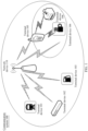
- the NTN communication system includes a satellite 201 and terminal devices 202.
- the terminal device 202 refer to related descriptions of the terminal devices 101 to 106.
- the satellite 201 may also be referred to as a high-altitude platform, a high-altitude aircraft, or a satellite base station.
- the satellite 201 may be considered as one or more network devices in the architecture of the terrestrial network communication system.
- the satellite 201 provides a communication service for the terminal devices 202, and the satellite 201 may further be connected to a core network device.
- a structure and a function of the satellite 201 refer to the foregoing descriptions of the network device.
- a communication manner between the satellite 201 and the terminal device 202 refer to the descriptions in FIG. 1 . Details are not described herein again.
- 5G is used as an example.
- An architecture of a 5G satellite communication system is shown in FIG. 3 .
- a ground terminal device accesses a network through 5G new radio.
- a 5G base station is deployed on a satellite, and is connected to a core network on the ground through a wireless link.
- a wireless link exists between satellites, to complete signaling exchanging and user data transmission between base stations.
- Devices and interfaces in FIG. 3 are described as follows:
- a 5G core network provides services such as user access control, mobility management, session management, user security authentication, and charging.
- the 5G core network includes a plurality of functional units, which can be classified into control-plane and data-plane functional entities.
- An access and mobility management unit (access and mobility management function, AMF) is responsible for user access management, security authentication, and mobility management.
- a user plane unit (user plane function, UPF) is responsible for managing functions such as user plane data transmission and traffic statistics collection.
- a session management function session management function (session management function, SMF) is mainly used for session management in a mobile network, for example, session establishment, modification, and release.
- a ground station is responsible for forwarding signaling and service data between a satellite base station and the 5G core network.
- 5G new radio is a wireless link between a terminal and a base station.
- An Xn interface is an interface between 5G base stations, and is mainly used for exchanging signaling, for example, handover.
- An NG interface is an interface between a 5G base station and the 5G core network, and mainly exchanges non-access stratum (non-access stratum, NAS) signaling or other signaling of the core network, and service data of a user.
- non-access stratum non-access stratum, NAS
- the network device in the terrestrial network communication system and the satellite in the NTN communication system may be collectively considered as network devices.
- An apparatus configured to implement a function of a network device may be a network device, or may be an apparatus, for example, a chip system, that can support the network device in implementing the function.
- the apparatus may be mounted in the network device.
- an example in which an apparatus configured to implement a function of a network device is a satellite is used to describe the technical solutions provided in embodiments of this application. It may be understood that, when the method provided in embodiments of this application is applied to the terrestrial network communication system, an action performed by the satellite may be performed by a base station or a network device.
- an apparatus configured to implement a function of a terminal device may be a terminal device, or may be an apparatus, for example, a chip system, that can support the terminal device in implementing the function.
- the apparatus may be mounted in the terminal device.
- the chip system may include a chip; or may include a chip and another discrete component.
- the satellite may be a geostationary satellite, a non-geostationary satellite, an artificial satellite, a low earth orbit satellite, a medium earth orbit satellite, a high earth orbit satellite, or the like. This is not specifically limited herein in this application.
- a new satellite network routing method is provided based on a feature that satellites in a ground co-track satellite chain have a same ground projected track.
- the method may be further applied to a communication system shown in FIG. 6 .
- Devices in FIG. 6 are described as follows:
- a ground co-track constellation may forward or route data of a terminal, a gateway station, and a core network.
- a satellite in the ground co-track constellation has an inter-satellite link, and may forward data to an adjacent satellite through the inter-satellite link.
- Ground facilities include ground devices, such as the terminal and a ground station, that are connected to the ground co-track constellation.
- the terminal accesses a network through the satellite, may communicate with the satellite through a service link, and may send data to another terminal or a core network (the internet) through the satellite (the ground co-track constellation).
- the gateway station communicates with the satellite (the ground co-track constellation) through a feeder link to provide transit between the satellite and the core network.
- an inter-satellite link between satellites may be constructed based on a property that satellites in a ground co-track satellite chain have a same ground projected track, to overcome a problem in the conventional technology that an inter-satellite link cannot be constructed based on a satellite constellation with discrete orbits.
- This application provides an inter-satellite link construction method. As shown in FIG. 7 , the method may be performed by a satellite.
- the satellite may be a geostationary satellite, a non-geostationary satellite, an artificial satellite, a low earth orbit satellite, a medium earth orbit satellite, a high earth orbit satellite, or the like. This is not specifically limited herein in this application.
- a first satellite and a second satellite are used as an example for description. A quantity of satellites is not limited in this application.
- the method is performed as follows.
- Step 701 The second satellite sends an inter-satellite link creation message of the second satellite to the first satellite, where the inter-satellite link creation message includes at least one of the following: an address of the second satellite and a satellite number of the second satellite, and the address of the second satellite is determined based on a projection location of the second satellite on a second ground projected track.
- the first satellite receives the inter-satellite link creation message of the second satellite.
- an inter-satellite link is a link for communication between satellites, and is also referred to as an inter satellite link or a crosslink (crosslink). Data transmission and exchanging between the satellites may be implemented through the inter-satellite link.
- a plurality of satellites are interconnected through the inter-satellite link, to form a space communication network in which the satellite is used as a switching node.
- An inter-satellite link creation message may include only an address of the satellite, may include only a number of the satellite, or may include both the address of the satellite and the number of the satellite. This is not specifically limited herein in this application.
- the address of the satellite may be determined based on a property that the satellite is a satellite on a ground co-track satellite chain and satellites in the ground co-track satellite chain have a same ground projected track, and a projection location of the satellite on the ground projected track.
- the address of the second satellite may be determined based on the projection location of the second satellite on the second ground projected track.
- An address of the first satellite may be determined based on a projection location of the first satellite on a first ground projected track.
- the address of the first satellite indicates a track point of the first satellite on the ground projected track or a point in a neighborhood range of the track point; or the address of the first satellite indicates a track segment of the first satellite on the ground projected track or a track segment in a neighborhood range of the track segment.
- the address of the second satellite indicates a track point of the second satellite on the ground projected track or a point in a neighborhood range of the track point; or the address of the second satellite indicates a track segment of the second satellite on the ground projected track or a track segment in a neighborhood range of the track segment.
- the address of the satellite is indicated by using a track point or a track segment on the ground projected track of the satellite, so that the property that the satellites in the ground co-track satellite chain have the same ground projected track can be fully used.
- routing and addressing routing and addressing complexity is reduced, and routing and addressing efficiency is improved.
- the track point is indicated by using one of the following parameters: a distance from a reference point moving along a first projected track to the track point, a satellite motion phase difference accumulated from the reference point moving along the first projected track to the track point, and a latitude difference accumulated from the reference point moving along the first projected track to the track point, where the reference point is any point on the first projected track, and the first projected track is a ground projected track of any ground co-track satellite chain.
- the track point may be indicated by using a distance from the reference point to the track point.
- the reference point is any point on a projected track 1, and a location 10 meters away from the reference point is the track point. In this case, the track point may be indicated by using 10 meters.
- the track point may be indicated by using a satellite motion phase difference accumulated from the reference point to the track point.
- the reference point is any point on a projected track 1, a satellite ground projection is located at the reference point at a moment 1, and the satellite ground projection is located at the track point after X moments.
- the track point may be indicated by using a satellite motion phase difference accumulated from the moment 1 to a moment X+1.
- the track point may be indicated by using a latitude difference accumulated from the reference point to the track point.
- the reference point is any point on a projected track 1
- the reference point is located at latitude 1
- Y latitude needs to be passed from the reference point to the track point.
- the track point may be indicated by using the Y latitude.
- the track point is indicated in different manners, so that routing and addressing flexibility can be improved.
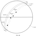
- a track location accumulated from the reference point to the track point may be defined as a ground projected track address (ground track address, GTA).
- GTA ground track address
- a track point shown by a pentagram is a reference point, if an accumulated latitude difference of a satellite moving along a ground projected track is used as a location difference, a GTA of a track point 1 is a latitude difference accumulated from the reference point to the track point 1, that is, 38.3 degrees, and a GTA of a track point 2 is a latitude difference accumulated from the reference point to the track point 2, that is, 517.1 degrees.
- each satellite track may be distinguished by using a track number, and a track location may be jointly described by using the track number and a location on the track.
- a track segment of the ground projected track may be defined as a ground projected track address range (ground track address range, GTAR), and may be generally described by using GTAs at two ends of the track, for example, a track GTAR between the track point 1 and the track point 2 is (GTA0, GTA1).
- the address of the satellite may be determined based on at least one of the following parameters: a longitude and latitude location of the satellite, an ephemeris of the satellite, or the satellite number of the satellite.
- current location information of the first satellite may be learned of based on a longitude and latitude location of the first satellite.
- An ephemeris of the first satellite includes information such as orbit information of the first satellite and an altitude of the first satellite.
- the current location information of the first satellite may be obtained based on the ephemeris of the first satellite.
- Satellite numbers may be sequentially numbered based on a sequence of the satellites in the ground co-track satellite chain.
- the ephemeris of the first satellite may be learned of based on a number of the first satellite, and a current location of the first satellite is further determined based on the ephemeris of the first satellite.
- a location of the first satellite on the ground projected track may be learned of based on the current location information of the first satellite, and the address of the first satellite may be obtained based on preset reference point information.
- the creation message further includes an identifier of the ground projected track of the second satellite.
- the creation message includes the identifier of the ground projected track of the second satellite, so that the first satellite can simply determine, based on the identifier of the ground projected track of the second satellite, whether the second satellite can construct an inter-satellite link to the first satellite.
- the address of the second satellite is alternatively determined based on the identifier of the second ground projected track.
- the address of the first satellite may alternatively be determined based on an identifier of the first ground projected track.
- a projected track of a satellite may be determined based on a track identifier of a ground co-track satellite chain on a ground projection. Based on this, it is simpler and more convenient to determine an address of the satellite.
- Step 702 If the second satellite and the first satellite satisfy an inter-satellite link matching rule, the first satellite creates the inter-satellite link between the first satellite and the second satellite, where the inter-satellite link matching rule is determined based on at least one of the following parameters: the address of the second satellite and the satellite number of the second satellite.
- the first satellite may determine, based on the inter-satellite link creation message sent by the second satellite, whether the first satellite and the second satellite satisfy the inter-satellite link matching rule.
- the first satellite may send an inter-satellite link creation success response message or identification information of the inter-satellite link to the second satellite.
- the identification information of the inter-satellite link may indicate that the inter-satellite link between the first satellite and the second satellite is successfully created.
- the first satellite may send a creation failure response message to the second satellite.
- the creation failure response message indicates that the inter-satellite link between the first satellite and the second satellite fails to be created.
- a creation failure cause is carried in the creation failure response message.
- the second satellite may learn, based on the response message, whether the first satellite and the second satellite can create the inter-satellite link. After creating the inter-satellite link between the first satellite and the second satellite, the first satellite may transmit data through the inter-satellite link.
- a specific function of the successfully created inter-satellite link is not specifically limited herein in this application.
- the inter-satellite link matching rule is determined based on the address of the second satellite and the satellite number of the second satellite. For example, after receiving the inter-satellite link creation message, the first satellite performs determining based on the address of the second satellite and the address of the first satellite, and if determining that the second satellite and the first satellite satisfy a preset address difference or distance threshold, the first satellite determines that the inter-satellite link matching rule is satisfied.
- the first satellite after receiving the inter-satellite link creation message, the first satellite performs determining based on the satellite number of the second satellite and a satellite number of the first satellite, and if determining that the second satellite and the first satellite satisfy a preset number difference or distance threshold, the first satellite determines that the inter-satellite link matching rule is satisfied. Therefore, after receiving the address of the second satellite or the satellite number of the second satellite, the first satellite may determine whether the second satellite and the first satellite satisfy the inter-satellite link matching rule.
- the inter-satellite link matching rule includes at least one of the following: the address of the second satellite and the address of the first satellite satisfy a satellite address difference, the satellite number of the second satellite and the satellite number of the first satellite satisfy a satellite number difference, and there is a mapping relationship between a track segment in which the second satellite is located and a track segment in which the first satellite is located.
- the satellite address difference is set to X, and it is determined, based on the address of the first satellite and the address of the second satellite, that a distance between the first satellite and the second satellite is less than or equal to X, it is determined that the first satellite and the second satellite can construct the inter-satellite link.
- the satellite number difference is set to A, and it is determined, based on the satellite number of the first satellite and the satellite number of the second satellite, that a satellite number difference between the first satellite and the second satellite is less than or equal to A, it is determined that the first satellite and the second satellite can construct the inter-satellite link.
- the first satellite can construct the inter-satellite link to the second satellite in the track segment 2.
- Example descriptions are merely provided herein, and no specific limitation is imposed.
- the inter-satellite link matching rule may be determined based on the address of the satellite and the number of the satellite, and depending on whether there is a mapping relationship between tracks in which the satellites are located. In this manner, it can be ensured that the satellite can establish an appropriate inter-satellite link, to ensure efficiency of constructing an inter-satellite link between ground co-track satellites, and ensure link stability, so as to avoid frequent link creation.
- the inter-satellite link matching rule is included in the creation message.
- the first satellite may determine, based on the inter-satellite link matching rule, whether the first satellite and the second satellite can create the inter-satellite link.
- the inter-satellite link matching rule may be pre-stored in the first satellite.
- the first satellite may determine, based on the inter-satellite link matching rule pre-stored in the first satellite, whether the first satellite and the second satellite can create the inter-satellite link.
- Location relationship 1 The first satellite and the second satellite belong to a same ground co-track satellite chain.
- Location relationship 2 The first satellite and the second satellite belong to similar ground co-track satellite chains.
- Location relationship 3 The first satellite and the second satellite belong to different ground co-track satellite chains, and the first satellite and the second satellite do not belong to similar ground co-track satellite chains.
- Case 1 The inter-satellite link matching rule is that the address of the second satellite and the address of the first satellite satisfy the satellite address difference.
- inter-satellite link matching rule is determined based on the satellite address difference; however, when the first satellite and the second satellite are in different location relationships, the inter-satellite link may be constructed in different manners. Details are as follows: Manner 1: The location relationship between the first satellite and the second satellite is the location relationship 1.
- a condition that satisfies the satellite address difference includes: the address of the first satellite and the address of the second satellite are less than a first address threshold. For example, when the address of the first satellite is indicated by using GTA1, the address of the second satellite is indicated by using GTA2, and an absolute value of a difference between GTA2 and GTA1 is less than a first address threshold GTAX, it is determined that the first satellite and the second satellite can construct the inter-satellite link.
- the second satellite may further search, in a first address threshold range, for satellites in the same ground co-track satellite chain, use all the satellites in the first address threshold range as candidate satellites for constructing the inter-satellite link, then select a first satellite (namely, the first satellite) closest to the second satellite from the candidate satellites, and send the inter-satellite link creation message, to construct the inter-satellite link between the second satellite and the first satellite; or set priorities for the candidate satellites based on properties (data transmission latencies, bandwidths, or the like) of the satellites, and use a satellite with a higher priority as the first satellite.
- Example descriptions are merely provided herein, and no specific limitation is imposed.
- a condition that satisfies the satellite address difference includes: a distance between the first satellite and the second satellite is less than a first distance threshold, or a distance between the first satellite and the second satellite is less than a first latitude threshold.
- the address of the first satellite is indicated by using GTA1
- the address of the second satellite is indicated by using GTA2
- an absolute value of a latitude difference between GTA2 and GTA1 is less than the first latitude threshold
- the second satellite may further search, in a first latitude threshold range, for satellites that are in the same ground co-track satellite chain and that are located in adjacent track circles, use all the satellites in the first latitude threshold range as candidate satellites for constructing the inter-satellite link, then select the first satellite from the candidate satellites, and send the inter-satellite link creation message to the first satellite, to construct the inter-satellite link between the first satellite and the second satellite.
- a satellite with a smallest latitude difference from the second satellite is selected as the first satellite, in other words, a latitude difference between the second satellite and the first satellite is min ( ⁇ GTA rel ); or a satellite with a high priority is selected as the first satellite.
- the priority may be set based on a property of the satellite.
- the property of the satellite may be specifically a data transmission latency, a bandwidth, or the like. Example descriptions are merely provided herein, and no specific limitation is imposed.
- how to construct an inter-satellite link may be further determined based on a distance between satellites in adjacent track circles. For example, when the address of the first satellite is indicated by using GTA1, the address of the second satellite is indicated by using GTA2, and an absolute value of a distance difference between GTA2 and GTA1 is less than the first distance threshold, it is determined that the first satellite and the second satellite can construct the inter-satellite link.
- the second satellite when establishing the inter-satellite link, may search, in a first distance threshold range of the address of the second satellite, for satellites that are in the same ground co-track satellite chain and that are located in adjacent track circles, use the satellites in the first distance threshold range as candidate satellites for constructing the inter-satellite link, then select the first satellite from the candidate satellites, and send the inter-satellite link creation message to the first satellite, to construct the inter-satellite link between the first satellite and the second satellite.
- a satellite closest to the second satellite is selected from the candidate satellites as the first satellite, to be specific, a distance between the second satellite and the first satellite may be min( ⁇ GTA rel ) + ⁇ Long neibor_loop * cos(i), where ⁇ Long neibor_loop is a difference between initial longitudes of the adjacent track circles, and i is an orbital inclination angle, in other words, a satellite with a high priority is selected from the candidate satellites as the first satellite.
- the priority of the satellite may be set based on a property of the satellite.
- the property of the satellite may be specifically a data transmission latency, a bandwidth, or the like. Example descriptions are merely provided herein, and no specific limitation is imposed.
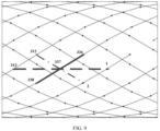
- FIG. 9 an example in which an inter-satellite link is configured for a satellite 337 is used for description.
- a solid line is an inter-satellite link between satellites (336 and 338) with a smallest GTA difference in a same track segment.
- a dashed line is an inter-satellite link between satellites (313 and 1) whose relative GTAs are closest in satellites in adjacent track circles.
- a dotted line is an inter-satellite link between satellites (312 and 2) that are closest to each other in the satellites in the adjacent track circles.
- Manner 2 The location relationship between the first satellite and the second satellite is the location relationship 2.
- a condition that satisfies the satellite address difference includes: a distance between the first satellite and the second satellite is less than a third distance threshold, or a distance between the first satellite and the second satellite is less than a third latitude threshold.
- the inter-satellite link when an inter-satellite link in similar ground co-track satellite chains is constructed, the inter-satellite link may be established between satellites that are closest or close to each other (less than the third distance threshold) in closest track circles; or the inter-satellite link may be constructed by selecting satellites whose latitude distances are closest or close to each other (less than the third latitude threshold) in closest track circles.
- the inter-satellite link may be established between satellites that are closest or close to each other (less than the third distance threshold) in closest track circles; or the inter-satellite link may be constructed by selecting satellites whose latitude distances are closest or close to each other (less than the third latitude threshold) in closest track circles.
- Case 2 The inter-satellite link matching rule is that the satellite number of the second satellite and the satellite number of the first satellite satisfy the satellite number difference.
- inter-satellite link matching rule is determined based on the satellite number difference; however, when the first satellite and the second satellite are in different location relationships, the inter-satellite link may be constructed in different manners. Details are as follows: Manner 1: The location relationship between the first satellite and the second satellite is the location relationship 1.
- a condition that satisfies the satellite number difference includes: the satellite number of the first satellite and the satellite number of the second satellite are less than a first number threshold. For example, when the satellite number of the first satellite is indicated by using a number 1, the satellite number of the second satellite is indicated by using a number 2, and an absolute value of a difference between the number 2 and the number 1 is less than a first number threshold number Y, it is determined that the first satellite and the second satellite can construct the inter-satellite link.
- the second satellite may further search, in a first number threshold range, for satellites that are in the same ground co-track satellite chain, use all the satellites in the first number threshold range as candidate satellites for constructing the inter-satellite link, then select the first satellite from the candidate satellites, and send the inter-satellite link creation message to the first satellite, to construct the inter-satellite link between the first satellite and the second satellite.
- a satellite closest to the second satellite is selected from the candidate satellites as the first satellite, or a satellite with a high priority is selected from the candidate satellites as the first satellite.
- the priority of the satellite may be set based on a property of the satellite.
- the property of the satellite may be specifically a data transmission latency, a bandwidth, or the like. Example descriptions are merely provided herein, and no specific limitation is imposed.
- a condition that satisfies the satellite number difference includes: a distance between the first satellite and the second satellite is less than a second distance threshold, or a distance between the first satellite and the second satellite is less than a second latitude threshold.
- Manner 2 The location relationship between the first satellite and the second satellite is the location relationship 2.
- a condition that satisfies the satellite number difference includes: a distance between the first satellite and the second satellite is less than a fourth distance threshold, or a distance between the first satellite and the second satellite is less than a fourth latitude threshold.
- the first address threshold, the first number threshold, the first distance threshold, the second distance threshold, the third distance threshold, the fourth distance threshold, the first latitude threshold, the second latitude threshold, the third latitude threshold, and the fourth latitude threshold mentioned in the case 1 and the case 2 may be flexibly set based on an actual situation, and specific values of the thresholds are not specifically limited herein in this application. Optionally, some thresholds may alternatively be set to be a same value. For example, the first latitude threshold is the same as the second latitude threshold. Example descriptions are merely provided herein, and no specific limitation is imposed.
- Case 3 The inter-satellite link matching rule is that there is the mapping relationship between the track segment in which the second satellite is located and the track segment in which the first satellite is located.
- inter-satellite link matching rule shown in the case 3 may adapt to the satellites in the location relationship 1, the location relationship 2, and the location relationship 3.
- the first satellite determines that there is the mapping relationship between the track segment in which the first satellite is located and the track segment in which the second satellite is located, and the first satellite constructs the inter-satellite link to the second satellite, where the mapping relationship indicates that an identifier of a first track segment in which the first satellite is located corresponds to an identifier of a second track segment in which the second satellite is located.
- a constant inter-satellite link may be established based on a mapping relationship existing between track segments.
- a long-time inter-satellite link cannot be established because flight speeds (vectors) of satellites in dissimilar ground co-track satellite chains are not constant.
- an inter-satellite link may be established for a period of time based on the foregoing mapping relationship. Therefore, two satellite chain track segments can be configured to establish the inter-satellite link. For example, pairing is performed according to the following rule: After the satellite enters a configured track number+GTAR, the satellite searches for a satellite in a track number+GTAR of another satellite chain, to construct an inter-satellite link.
- the satellite disconnects the inter-satellite link.
- two track segments having an intersection point are paired, and an inter-satellite link established between satellites in the two track segments may be maintained for a long time.
- a satellite on a track 0 searches for a satellite in GTAR1 on a track 1, to establish an inter-satellite link.
- the satellite disconnects the inter-satellite link.
- the satellite on the track 0 may send a broadcast message or a multicast message to a satellite in GTAR2.
- the message includes a track number and a track segment of the satellite, or satellite ephemeris information
- the satellite that receives the broadcast message or the multicast message may directly determine, based on the track number and the track segment in the message, whether a mapping relationship is satisfied; and if the mapping relationship is satisfied, construct an inter-satellite link; or may determine, through calculation based on the satellite ephemeris information, a track number and a track segment of the satellite, and then determine whether a mapping relationship is satisfied, and whether to construct an inter-satellite link.
- constructing the inter-satellite link based on the foregoing case can ensure efficiency of constructing an inter-satellite link between ground co-track satellites.
- the first satellite may further establish an inter-satellite link between the first satellite and another satellite, where the establishing an inter-satellite link between the first satellite and another satellite includes at least one of the following trigger conditions: the inter-satellite link between the first satellite and the second satellite is faulty (for example, a communication link between the first satellite and the second satellite is disconnected, or communication of the second satellite is faulty), a satellite address difference between the first satellite and the second satellite exceeds a value of the satellite address difference, a satellite number difference between the first satellite and the second satellite exceeds a value of the satellite number difference, and there is no mapping relationship between the track segment in which the second satellite is located and the track segment in which the first satellite is located.
- the inter-satellite link between the first satellite and the second satellite is faulty (for example, a communication link between the first satellite and the second satellite is disconnected, or communication of the second satellite is faulty)
- a satellite address difference between the first satellite and the second satellite exceeds a value of the satellite address difference
- constructing the inter-satellite link between the first satellite and the another satellite can ensure efficiency of constructing an inter-satellite link between ground co-track satellites.
- the first satellite may further re-establish an inter-satellite link between the first satellite and the second satellite, where the re-establishing an inter-satellite link between the first satellite and the second satellite includes at least one of the following trigger conditions: a value of the satellite address difference is changed, a value of the satellite number difference is changed, or the mapping relationship between the track segment in which the second satellite is located and the track segment in which the first satellite is located is changed (for example, the mapping relationship between the track segment 1 and the track segment 2 is changed to a mapping relationship between the track segment 1 and a track segment 3).
- the inter-satellite link matching rule when the inter-satellite link matching rule is changed, the inter-satellite link between the first satellite and the second satellite is reconstructed, so that efficiency of constructing the inter-satellite link can be ensured.
- each device may include a corresponding hardware structure and/or software module for performing each function.
- a person skilled in the art should be easily aware that, in embodiments of this application, the units and algorithm steps in the examples described with reference to embodiments disclosed in this specification can be implemented by using hardware or a combination of hardware and computer software. Whether a function is performed by hardware or hardware driven by computer software depends on particular applications and design constraints of the technical solutions. A person skilled in the art may use different methods to implement the described functions for each particular application, but it should not be considered that the implementation goes beyond the scope of this application.
- the device may be divided into functional units based on the foregoing method examples.
- each functional unit may be obtained through division based on a corresponding function, or two or more functions may be integrated into one unit.
- the integrated unit may be implemented in a form of hardware, or may be implemented in a form of a software functional unit.
- FIG. 11 is a possible example block diagram of a communication apparatus according to an embodiment of this application.
- the communication apparatus 1100 may include a processing unit 1101 and a transceiver unit 1102.
- the processing unit 1101 is configured to control and manage an action of the communication apparatus 1100.
- the transceiver unit 1102 is configured to support communication between the communication apparatus 1100 and another device.
- the transceiver unit 1102 may include a receiving unit and/or a sending unit, which are respectively configured to perform a receiving operation and a sending operation.
- the communication apparatus 1100 may further include a storage unit, configured to store program code and/or data of the communication apparatus 1100.
- the transceiver unit may be referred to as an input/output unit, a communication unit, or the like, and the transceiver unit may be a transceiver.
- the processing unit may be a processor.
- the transceiver unit may be an input/output interface, an input/output circuit, an input/output pin, or the like, and may also be referred to as an interface, a communication interface, an interface circuit, or the like; and the processing unit may be a processor, a processing circuit, a logic circuit, or the like.
- the apparatus may be the first satellite, the second satellite, or the like.
- the transceiver unit 1102 is configured to receive an inter-satellite link creation message of a second satellite, where the inter-satellite link creation message includes at least one of the following: an address of the second satellite and a satellite number of the second satellite, and the address of the second satellite is determined based on a projection location of the second satellite on a second ground projected track; and the processing unit 1101 is configured to: if the second satellite and the first satellite satisfy an inter-satellite link matching rule, the first satellite creates an inter-satellite link between the first satellite and the second satellite, where the inter-satellite link matching rule is determined based on at least one of the following parameters: the address of the second satellite and the satellite number of the second satellite.
- the processing unit 1101 is configured to determine an inter-satellite link creation message; and the transceiver unit 1102 is configured to send the inter-satellite link creation message to a first satellite, where the inter-satellite link creation message includes at least one of the following: an address of the second satellite and a satellite number of the second satellite, and the address of the second satellite is determined based on a projection location of the second satellite on a second ground projected track; and an inter-satellite link matching rule is determined based on at least one of the following parameters: the address of the second satellite and the satellite number of the second satellite.
- the inter-satellite link matching rule includes at least one of the following: the address of the second satellite and an address of the first satellite satisfy a satellite address difference, the satellite number of the second satellite and a satellite number of the first satellite satisfy a satellite number difference, and there is a mapping relationship between a track segment in which the second satellite is located and a track segment in which the first satellite is located; and the address of the first satellite is determined based on a projection location of the first satellite on a first ground projected track.
- the inter-satellite link matching rule is included in the creation message, or is pre-stored in the first satellite.
- the creation message further includes an identifier of the ground projected track of the second satellite.
- the address of the second satellite is alternatively determined based on the identifier of the second ground projected track.
- a condition that satisfies the satellite address difference includes: the address of the first satellite and the address of the second satellite are less than a first address threshold; and/or when the first satellite and the second satellite belong to a same ground co-track satellite chain, and the first satellite and the second satellite belong to adjacent track circles, a condition that satisfies the satellite address difference includes: a distance between the first satellite and the second satellite is less than a first distance threshold, or a distance between the first satellite and the second satellite is less than a first latitude threshold, where the ground co-track satellite chain includes a plurality of satellites that have a same ground projected track; and the track circle is a track segment that is of the ground projected track of the ground co-track satellite chain and that traverses a reference line twice in a same direction, and latitude of the reference line is fixed.
- a condition that satisfies the satellite number difference includes: the satellite number of the first satellite and the satellite number of the second satellite are less than a first number threshold; and/or when the first satellite and the second satellite belong to a same ground co-track satellite chain, and the first satellite and the second satellite belong to adjacent track circles, a condition that satisfies the satellite number difference includes: a distance between the first satellite and the second satellite is less than a second distance threshold, or a distance between the first satellite and the second satellite is less than a second latitude threshold, where the ground co-track satellite chain includes a plurality of satellites that have a same ground projected track; and the track circle is a track segment that is of the ground projected track of the ground co-track satellite chain and that traverses a reference line twice in a same direction, and latitude of the reference line is fixed.
- a condition that satisfies the satellite address difference includes: a distance between the first satellite and the second satellite is less than a third distance threshold, or a distance between the first satellite and the second satellite is less than a third latitude threshold, where satellites in the similar ground co-track satellite chains have a same orbital altitude and a same orbital inclination angle, and have only a longitude offset between ground projected tracks.
- a condition that satisfies the satellite number difference includes: a distance between the first satellite and the second satellite is less than a fourth distance threshold, or a distance between the first satellite and the second satellite is less than a fourth latitude threshold, where satellites in the similar ground co-track satellite chains have a same orbital altitude and a same orbital inclination angle, and have only a longitude offset between ground projected tracks.
- the mapping relationship indicates that an identifier of a first track segment in which the first satellite is located corresponds to an identifier of a second track segment in which the second satellite is located.
- the first satellite and the second satellite belong to a same ground co-track satellite chain; the first satellite and the second satellite belong to similar ground co-track satellite chains; or the first satellite and the second satellite belong to different ground co-track satellite chains, and the first satellite and the second satellite do not belong to similar ground co-track satellite chains.
- the address of the first satellite indicates a track point of the first satellite on the ground projected track or a point in a neighborhood range of the track point; or the address of the first satellite indicates a track segment of the first satellite on the ground projected track or a track segment in a neighborhood range of the track segment; and the address of the second satellite indicates a track point of the second satellite on the ground projected track or a point in a neighborhood range of the track point; or the address of the second satellite indicates a track segment of the second satellite on the ground projected track or a track segment in a neighborhood range of the track segment.
- the track point is indicated by using one of the following parameters: a distance from a reference point moving along a first projected track to the track point, a satellite motion phase difference accumulated from the reference point moving along the first projected track to the track point, and a latitude difference accumulated from the reference point moving along the first projected track to the track point, where the reference point is any point on the first projected track, and the first projected track is a ground projected track of any ground co-track satellite chain.
- the processing unit 1101 is further configured to establish an inter-satellite link between the first satellite and another satellite, where the establishing an inter-satellite link between the first satellite and another satellite includes at least one of the following trigger conditions: the inter-satellite link between the first satellite and the second satellite is faulty, a satellite address difference between the first satellite and the second satellite exceeds a value of the satellite address difference, a satellite number difference between the first satellite and the second satellite exceeds a value of the satellite number difference, and there is no mapping relationship between the track segment in which the second satellite is located and the track segment in which the first satellite is located.
- the processing unit 1101 is further configured to re-establish an inter-satellite link between the first satellite and the second satellite, where the re-establishing an inter-satellite link between the first satellite and the second satellite includes at least one of the following trigger conditions: a value of the satellite address difference is changed, a value of the satellite number difference is changed, or the mapping relationship between the track segment in which the second satellite is located and the track segment in which the first satellite is located is changed.
- FIG. 12 shows a communication apparatus 1200 further provided in this application.
- the communication apparatus 1200 may be a chip or a chip system.
- the communication apparatus may be located in the device in any one of the foregoing method embodiments, for example, the first satellite, the network device, or the ground device, to perform an action corresponding to the device.
- the chip system may include a chip, or may include a chip and another discrete device.
- the communication apparatus 1200 includes a processor 1210.
- the processor 1210 is configured to execute a computer program stored in a memory 1220, to implement actions of the devices in any one of the foregoing method embodiments.
- the communication apparatus 1200 may further include the memory 1220, configured to store the computer program.
- the memory 1220 is coupled to the processor 1210.
- the coupling is an indirect coupling or a communication connection between apparatuses, units, or modules, may be in an electrical form, a mechanical from, or another form, and is used for information exchanging between the apparatuses, the units, or the modules.
- the memory 1220 and the processor 1210 are integrated together.
- processors 1210 There may be one or more processors 1210 and one or more memories 1220. This is not limited.
- the communication apparatus 1200 may be the first satellite or the ground device in the foregoing method embodiments.
- a specific connection medium between the transceiver 1230, the processor 1210, and the memory 1220 is not limited in this embodiment of this application.
- the memory 1220, the processor 1210, and the transceiver 1230 are connected through a bus in FIG. 12 .
- the bus is represented by using a thick line in FIG. 12 .
- a manner of a connection between other components is merely an example for description, and is not limited thereto.
- the bus may be classified into an address bus, a data bus, a control bus, and the like. For ease of representation, only one bold line indicates the bus in FIG. 12 , but this does not mean that there is only one bus or only one type of bus.
- the processor may be a general-purpose processor, a digital signal processor, an application-specific integrated circuit, a field programmable gate array or another programmable logic device, a discrete gate or transistor logic device, or a discrete hardware component, and may implement or execute the methods, steps, and logical block diagrams disclosed in embodiments of this application.
- the general-purpose processor may be a microprocessor, any conventional processor, or the like. The steps of the method disclosed with reference to embodiments of this application may be directly performed by a hardware processor, or may be performed by a combination of hardware in the processor and a software module.
- the memory may be a nonvolatile memory, such as a hard disk drive (hard disk drive, HDD) or a solid-state drive (solid-state drive, SSD), or may be a volatile memory (volatile memory), such as a random access memory (random access memory, RAM).
- the memory may be any other medium that can be configured to carry or store expected program code in a form of an instruction or a data structure and that can be accessed by a computer, but is not limited thereto.
- the memory in this embodiment of this application may be a circuit or any other apparatus that can implement a storage function, and is configured to store a computer program, program instructions, and/or data.
- An embodiment of this application further provides another communication apparatus 1300, including an interface circuit 1310 and a logic circuit 1320.
- the interface circuit 1310 may be understood as an input/output interface, and may be configured to perform sending and receiving steps of each device in any one of the foregoing method embodiments.
- the logic circuit 1320 may be configured to run code or instructions to perform the method performed by each device in any one of the foregoing embodiments. Details are not described again.
- an embodiment of this application further provides a computer-readable storage medium.
- the computer-readable storage medium stores instructions. When the instructions are executed, the method performed by each device in any one of the foregoing method embodiments is implemented.
- the computer-readable storage medium may include any medium that can store program code, such as a USB flash drive, a removable hard disk drive, a read-only memory, a random access memory, a magnetic disk, or an optical disc.
- an embodiment of this application provides a communication system.
- the communication system includes the first satellite, the ground device, and the another satellite mentioned in any one of the foregoing method embodiments, and may be configured to perform the method performed by each device in any one of the foregoing method embodiments.
- this application may be provided as a method, a system, or a computer program product. Therefore, this application may use a form of hardware only embodiments, software only embodiments, or embodiments with a combination of software and hardware. In addition, this application may use a form of a computer program product that is implemented on one or more computer-usable storage media (including but not limited to a magnetic disk memory, a compact disc read-only memory (compact disc read-only memory, CD-ROM), an optical memory, and the like) that include computer-usable program code.
- a computer-usable storage media including but not limited to a magnetic disk memory, a compact disc read-only memory (compact disc read-only memory, CD-ROM), an optical memory, and the like.
- These computer program instructions may be provided for a general-purpose computer, a dedicated computer, an embedded processor, or a processor of another programmable data processing apparatus to generate a machine, so that the instructions executed by a computer or the processor of any other programmable data processing apparatus generate an apparatus for implementing a specific function in one or more procedures in the flowcharts and/or in one or more blocks in the block diagrams.
- these computer program instructions may be stored in a computer-readable memory that can instruct the computer or the another programmable data processing apparatus to work in a specific manner, so that the instructions stored in the computer-readable memory generate an artifact that includes an instruction apparatus.
- the instruction apparatus implements a specified function in one or more processes in the flowcharts and/or in one or more blocks in the block diagrams.
- These computer program instructions may alternatively be loaded onto a computer or another programmable data processing apparatus, so that a series of operation steps are performed on the computer or another programmable apparatus to generate computer-implemented processing. Therefore, the instructions executed on the computer or another programmable apparatus provide steps for implementing a specific function in one or more procedures in the flowcharts and/or in one or more blocks in the block diagrams.
Landscapes
- Engineering & Computer Science (AREA)
- Computer Networks & Wireless Communication (AREA)
- Signal Processing (AREA)
- Physics & Mathematics (AREA)
- Astronomy & Astrophysics (AREA)
- Aviation & Aerospace Engineering (AREA)
- General Physics & Mathematics (AREA)
- Radio Relay Systems (AREA)
- Mobile Radio Communication Systems (AREA)
Applications Claiming Priority (2)
| Application Number | Priority Date | Filing Date | Title |
|---|---|---|---|
| CN202210673153.7A CN117278091A (zh) | 2022-06-14 | 2022-06-14 | 一种星间链路构建方法及通信装置 |
| PCT/CN2023/097570 WO2023241362A1 (zh) | 2022-06-14 | 2023-05-31 | 一种星间链路构建方法及通信装置 |
Publications (2)
| Publication Number | Publication Date |
|---|---|
| EP4529042A1 true EP4529042A1 (de) | 2025-03-26 |
| EP4529042A4 EP4529042A4 (de) | 2025-09-24 |
Family
ID=89192226
Family Applications (1)
| Application Number | Title | Priority Date | Filing Date |
|---|---|---|---|
| EP23822932.2A Pending EP4529042A4 (de) | 2022-06-14 | 2023-05-31 | Verfahren zur herstellung einer verbindung zwischen satelliten und kommunikationsvorrichtung |
Country Status (4)
| Country | Link |
|---|---|
| US (1) | US20250112688A1 (de) |
| EP (1) | EP4529042A4 (de) |
| CN (1) | CN117278091A (de) |
| WO (1) | WO2023241362A1 (de) |
Families Citing this family (6)
| Publication number | Priority date | Publication date | Assignee | Title |
|---|---|---|---|---|
| WO2025148068A1 (en) * | 2024-01-12 | 2025-07-17 | Nec Corporation | Devices and methods for communication |
| CN120454808A (zh) * | 2024-02-07 | 2025-08-08 | 维沃移动通信有限公司 | 通信的方法、装置及通信设备 |
| CN118157794B (zh) * | 2024-03-05 | 2024-09-10 | 中国人民解放军军事科学院系统工程研究院 | 一种星间太赫兹信道摄动影响分析方法 |
| CN118509039B (zh) * | 2024-07-22 | 2024-10-22 | 之江实验室 | 多态卫星间激光通信链路仿真方法、装置及电子设备 |
| CN119154934B (zh) * | 2024-09-05 | 2025-03-14 | 湖北亿立能科技股份有限公司 | 一种低轨卫星与高轨卫星互联通信一体化终端装置 |
| CN120582686B (zh) * | 2025-07-31 | 2025-11-04 | 中国星网网络创新研究院有限公司 | 星间激光链路建立方法、装置及通信系统 |
Family Cites Families (5)
| Publication number | Priority date | Publication date | Assignee | Title |
|---|---|---|---|---|
| US6249513B1 (en) * | 1998-02-06 | 2001-06-19 | Com Dev Limited | Managing inter-satellite connections in a constellation with overlapping orbital planes |
| FR2818055A1 (fr) * | 2000-07-27 | 2002-06-14 | Cit Alcatel | Procede et systeme de telecommunication par satellites et terminal pour un tel systeme |
| CN108881029B (zh) * | 2018-06-07 | 2020-10-16 | 北京邮电大学 | 基于星地解耦的低轨卫星网络编址和路由方法及系统 |
| CN111294108B (zh) * | 2020-01-15 | 2021-12-14 | 南京航空航天大学 | 一种面向正交圆轨道构型卫星星座的高效路由方法 |
| CN111953399B (zh) * | 2020-07-10 | 2022-06-17 | 东南大学 | 一种低轨卫星通信网络中的星间路由方法 |
-
2022
- 2022-06-14 CN CN202210673153.7A patent/CN117278091A/zh active Pending
-
2023
- 2023-05-31 EP EP23822932.2A patent/EP4529042A4/de active Pending
- 2023-05-31 WO PCT/CN2023/097570 patent/WO2023241362A1/zh not_active Ceased
-
2024
- 2024-12-12 US US18/979,177 patent/US20250112688A1/en active Pending
Also Published As
| Publication number | Publication date |
|---|---|
| CN117278091A (zh) | 2023-12-22 |
| WO2023241362A1 (zh) | 2023-12-21 |
| US20250112688A1 (en) | 2025-04-03 |
| EP4529042A4 (de) | 2025-09-24 |
Similar Documents
| Publication | Publication Date | Title |
|---|---|---|
| EP4529042A1 (de) | Verfahren zur herstellung einer verbindung zwischen satelliten und kommunikationsvorrichtung | |
| Jung et al. | Satellite clustering for non-terrestrial networks: Concept, architectures, and applications | |
| EP4529280A1 (de) | Satellitennetzwerk-routingverfahren und kommunikationsvorrichtung | |
| Harounabadi et al. | Toward integration of 6G-NTN to terrestrial mobile networks: Research and standardization aspects | |
| Rago et al. | Multi-layer NTN architectures toward 6G: The ITA-NTN view | |
| CN115243296A (zh) | 卫星通信系统的优化仿真方法及装置 | |
| WO2022156519A1 (zh) | 一种无线通信的方法及装置 | |
| US20240283528A1 (en) | Communication method and related apparatus | |
| US20250344120A1 (en) | Mobility management method and communication apparatus | |
| CN116017600A (zh) | 小区切换的方法、终端设备、网络设备及存储介质 | |
| CN114641081A (zh) | 一种无线通信的方法及装置 | |
| WO2025108263A1 (zh) | 信息发送方法及装置 | |
| US12483326B2 (en) | Wireless communication method and apparatus | |
| Radhakishnan et al. | The performance evaluation of distributed inter-satellite communication protocols for cube satellite systems | |
| Aygül et al. | Centralized and decentralized ml-enabled integrated terrestrial and non-terrestrial networks | |
| CN117643108A (zh) | 数据传输处理方法、装置、设备及存储介质 | |
| US20250317187A1 (en) | Signal transmission method and apparatus | |
| JP7765571B2 (ja) | Vlos分離無線およびコア/基地局ネットワーク制御に基づくntn | |
| EP4651532A1 (de) | Verfahren und vorrichtungen zur drahtlosen kommunikation | |
| WO2025223238A1 (zh) | 一种通信方法及相关装置 | |
| WO2025223273A1 (zh) | 一种通信方法及相关装置 | |
| CN121604059A (zh) | 一种通信方法及装置 | |
| CN120417105A (zh) | 一种通信方法及装置 | |
| WO2025241978A1 (zh) | 一种通信方法及相关装置 | |
| WO2025113151A1 (zh) | 一种通信方法、通信装置及介质 |
Legal Events
| Date | Code | Title | Description |
|---|---|---|---|
| STAA | Information on the status of an ep patent application or granted ep patent |
Free format text: STATUS: THE INTERNATIONAL PUBLICATION HAS BEEN MADE |
|
| PUAI | Public reference made under article 153(3) epc to a published international application that has entered the european phase |
Free format text: ORIGINAL CODE: 0009012 |
|
| STAA | Information on the status of an ep patent application or granted ep patent |
Free format text: STATUS: REQUEST FOR EXAMINATION WAS MADE |
|
| 17P | Request for examination filed |
Effective date: 20241220 |
|
| AK | Designated contracting states |
Kind code of ref document: A1 Designated state(s): AL AT BE BG CH CY CZ DE DK EE ES FI FR GB GR HR HU IE IS IT LI LT LU LV MC ME MK MT NL NO PL PT RO RS SE SI SK SM TR |
|
| DAV | Request for validation of the european patent (deleted) | ||
| DAX | Request for extension of the european patent (deleted) | ||
| A4 | Supplementary search report drawn up and despatched |
Effective date: 20250822 |
|
| RIC1 | Information provided on ipc code assigned before grant |
Ipc: H04B 7/185 20060101AFI20250818BHEP Ipc: H04L 45/74 20220101ALI20250818BHEP |
|
| GRAP | Despatch of communication of intention to grant a patent |
Free format text: ORIGINAL CODE: EPIDOSNIGR1 |
|
| STAA | Information on the status of an ep patent application or granted ep patent |
Free format text: STATUS: GRANT OF PATENT IS INTENDED |