EP4531020A1 - System und verfahren zur hinderniserkennung bei einem flugzeug - Google Patents
System und verfahren zur hinderniserkennung bei einem flugzeug Download PDFInfo
- Publication number
- EP4531020A1 EP4531020A1 EP23199905.3A EP23199905A EP4531020A1 EP 4531020 A1 EP4531020 A1 EP 4531020A1 EP 23199905 A EP23199905 A EP 23199905A EP 4531020 A1 EP4531020 A1 EP 4531020A1
- Authority
- EP
- European Patent Office
- Prior art keywords
- systems
- aircraft
- data
- collision avoidance
- information
- Prior art date
- Legal status (The legal status is an assumption and is not a legal conclusion. Google has not performed a legal analysis and makes no representation as to the accuracy of the status listed.)
- Pending
Links
Images

Classifications
-
- G—PHYSICS
- G01—MEASURING; TESTING
- G01S—RADIO DIRECTION-FINDING; RADIO NAVIGATION; DETERMINING DISTANCE OR VELOCITY BY USE OF RADIO WAVES; LOCATING OR PRESENCE-DETECTING BY USE OF THE REFLECTION OR RERADIATION OF RADIO WAVES; ANALOGOUS ARRANGEMENTS USING OTHER WAVES
- G01S13/00—Systems using the reflection or reradiation of radio waves, e.g. radar systems; Analogous systems using reflection or reradiation of waves whose nature or wavelength is irrelevant or unspecified
- G01S13/88—Radar or analogous systems specially adapted for specific applications
- G01S13/93—Radar or analogous systems specially adapted for specific applications for anti-collision purposes
- G01S13/933—Radar or analogous systems specially adapted for specific applications for anti-collision purposes of aircraft or spacecraft
-
- G—PHYSICS
- G08—SIGNALLING
- G08G—TRAFFIC CONTROL SYSTEMS
- G08G5/00—Traffic control systems for aircraft
- G08G5/80—Anti-collision systems
-
- G—PHYSICS
- G06—COMPUTING OR CALCULATING; COUNTING
- G06N—COMPUTING ARRANGEMENTS BASED ON SPECIFIC COMPUTATIONAL MODELS
- G06N3/00—Computing arrangements based on biological models
- G06N3/02—Neural networks
-
- G—PHYSICS
- G08—SIGNALLING
- G08G—TRAFFIC CONTROL SYSTEMS
- G08G5/00—Traffic control systems for aircraft
- G08G5/20—Arrangements for acquiring, generating, sharing or displaying traffic information
- G08G5/21—Arrangements for acquiring, generating, sharing or displaying traffic information located onboard the aircraft
-
- G—PHYSICS
- G08—SIGNALLING
- G08G—TRAFFIC CONTROL SYSTEMS
- G08G5/00—Traffic control systems for aircraft
- G08G5/20—Arrangements for acquiring, generating, sharing or displaying traffic information
- G08G5/22—Arrangements for acquiring, generating, sharing or displaying traffic information located on the ground
-
- G—PHYSICS
- G08—SIGNALLING
- G08G—TRAFFIC CONTROL SYSTEMS
- G08G5/00—Traffic control systems for aircraft
- G08G5/20—Arrangements for acquiring, generating, sharing or displaying traffic information
- G08G5/26—Transmission of traffic-related information between aircraft and ground stations
-
- G—PHYSICS
- G08—SIGNALLING
- G08G—TRAFFIC CONTROL SYSTEMS
- G08G5/00—Traffic control systems for aircraft
- G08G5/50—Navigation or guidance aids
- G08G5/51—Navigation or guidance aids for control when on the ground, e.g. taxiing or rolling
-
- G—PHYSICS
- G08—SIGNALLING
- G08G—TRAFFIC CONTROL SYSTEMS
- G08G5/00—Traffic control systems for aircraft
- G08G5/70—Arrangements for monitoring traffic-related situations or conditions
- G08G5/72—Arrangements for monitoring traffic-related situations or conditions for monitoring traffic
- G08G5/723—Arrangements for monitoring traffic-related situations or conditions for monitoring traffic from the aircraft
Definitions
- the present disclosure relates to a system and method for detection and alerting of obstacles on path during surface and near-surface operations of aircraft.
- ADS-B Automatic Dependent Surveillance - Broadcast
- the aerodrome surface may refer to, but is not limited to, the runways, taxiways, aprons, etc., from which aircraft operations occur.
- Sensing system technologies may be cooperative or non-cooperative.
- Cooperative sensing systems are able to process data transmitted by other vehicles.
- Non-cooperative sensing systems are able to process information from objects which do not actively transmit information to other objects.
- a collision avoidance system for aggregating and processing data when an aircraft is on or near the ground, the collision avoidance system comprising:
- Collecting both object data and contextual data results in the use of a wide range of data to determine a list of detected objects, and thus may form a more accurate and relevant list of detected objects. Combining the data from multiple types of sensors may result in a more holistic, reliable and detailed view of the aircraft's environment.
- the contextualisation of the aggregated list of objects allows for object relevance filtering and customisation of the data based on end user preference. This may result in an improved and more unified situational awareness around the aircraft.
- the objects detected around the aircraft may include one or more of: other aircraft, aerodrome vehicles, aerodrome signage, foreign objects, debris, poles, wildlife and buildings. More generally, the objects detected around the aircraft may be interpreted as any type of object which can pose a threat to the aircraft.
- Providing a collision avoidance system that is capable of detecting a wide range of object types may result in more effective and versatile collision avoidance.
- the collision avoidance system may be configured to, when the aircraft is within a specified range of the aerodrome surface, commence operation as the aircraft approaches the ground, remain active during aerodrome surface operations, and cease operation after take-off.
- the specified range may be within 10,000 m (e.g., within 5,000 m) of the aerodrome surface and/or below 500 m (e.g., below 300 m) above the elevation of the aerodrome surface.
- the aerodrome surface may refer to, but is not limited to, the runways, taxiways, aprons, etc., from which aircraft operations occur.
- Specifying a particular operation range of the system from the aerodrome surface may reduce the overall power consumption of the system since it is inactive during flight.
- a predetermined range may be used based on existing data, e.g., from databases.
- the collision avoidance system may support either manned or unmanned aircraft.
- the system may support a pilot and/or flight crew on a manned aircraft, or the system may be used by a downstream system for controlling movement of the aircraft on the ground, such as in autonomous taxiing operations.
- Providing a collision avoidance system which is suitable for both manned and unmanned operation may result in a more adaptable system which is easy to use across a wide range of aircraft types.
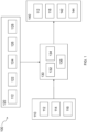
- the plurality of aircraft systems may comprise input systems configured to provide the object data.
- the plurality of aircraft systems may also comprise support systems configured to provide the contextual data.
- the aircraft's own subsystems may comprise, but are not limited to the non-cooperative sensing systems, cooperative sensing systems and the navigation systems.
- the input systems may comprise non-cooperative sensing systems comprising sensors on board the aircraft capable of detecting objects not actively providing information about themselves.
- the sensors may be vision-based sensors.
- the input systems may also comprise cooperative sensing systems comprising sensors capable of detecting data transmitted by other vehicles relating to the position and velocity of the other vehicles.
- the input systems may also comprise external surveillance systems and services capable of detecting data about objects on the aerodrome surface.
- the data received by the non-cooperative sensing systems about objects not actively providing information about themselves may include objects which are not equipped with ADS-B technologies.
- the data received by the cooperative sensing systems and transmitted by other vehicles may include vehicles which are equipped with ADS-B technologies.
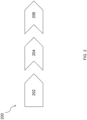
- the method 200 aggregates the output of both ownship and exogenous sensors to provide a holistic view of the obstacles around the ownship.
- the method then contextualises this data to determine the relevance of the detected obstacles. This is achieved via a data fusion step and a data contextualisation step.
- the method 200 therefore comprises method steps including, but not limited to, ownship data fusion block 202, exogenous data fusion block 204, and data contextualisation block 206.
- the ownship data fusion block 202 data received from the ownship subsystems, e.g., the non-cooperative sensing systems 112 and the navigation systems 122, are fused together to provide a first output.
- the first output comprises an initial view of the detected objects in the form of an initial list, which provides a situational awareness based solely on data generated by the ownship sensors.
- the initial list of objects is provided along with georeferenced information regarding the position, velocity and heading of each object.
- exogenous data fusion block 204 data received from external sources, e.g., the cooperative sensing systems 114 and the external surveillance systems and services 116, are added and fused together with the first output of the ownship data fusion block 202 to provide a second output.
- the second output comprises an aggregated list of detected objects.
- the second output also comprises information relating to object positions, velocities and any other available information. This data is provided from a different reference frame to the ownship data.
- information contained in the databases 128 is provided in a world reference frame using latitude and longitude values, while information provided by the ownship data fusion block 202 is provided in an ownship reference frame using range and bearing.
- the exogenous data fusion block 204 performs the relevant coordinate transformations to allow the data from the databases 128 to be used in combination with the first output of the ownship data fusion block 202. This data is then used to correlate detected objects with the position of known buildings and airport structures.
- the data fusion step comprises solely the ownship data fusion block 202, solely the exogenous data fusion block 204, or any combination thereof.
- the second output (i.e., the output of the exogenous data fusion block 204) is contextualised using data provided by the support systems 120.
- the data is used to determine relevance of the detected objects in the form of threat levels, as well as providing alerts and indications to the downstream consumers.
- the alerts and indications include graphical items displayed on the HMIs 142 or data that are used by a guidance system for avoiding collisions with the detected objects.
- the HMIs 142 include audio feedback to the crew in the form of aural alerts and/or warnings.
- the data contextualisation block 206 configures the output such that all objects located outside of the runway are excluded when providing information to the output systems 140.
- alerts are generated when an object is detected along a taxi route assigned to the ownship, since the object may present a threat. Alerts are also generated when a conflict with another aircraft manoeuvring on the surface is detected or predicted.
- the information inferred by the data fusion block 204 is used to implement prediction capabilities to support the data contextualisation block 206. For example, airport maps and other aircraft position and velocity information is used to predict potential taxi routes, which is then used to identify potential conflicts with the taxi route assigned to the ownship.
- the method 200 leverages data fusion techniques to aggregate and correlate the detections of multiple sensing systems with the prior knowledge of the environment. For example, when the fields of view or coverage areas of two or more sensing systems overlap, the detections of objects in the overlapping regions are correlated to identify a set of unique objects in the region. This provides accurate information regarding the position and velocity of each object, leveraging the availability of multiple detections and associated measurements for the same object.
- This information aggregation is also used to identify and classify objects, e.g., to discriminate a marshaller wearing a reflective vest and/or holding a light wand from an ordinary person.
- the information aggregation is also used to classify vehicles from the set of detected objects, e.g., to discriminate an airport surface vehicle from an aircraft or a rotorcraft.
- Data fusion techniques used by the method 200 may adopt heuristic algorithms and/or machine learning models.
- neural networks may be used for classification.
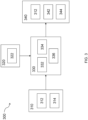
- Figure 3 shows an exemplary implementation of Figure 1 , wherein a system 300 is based upon weather radar and ADS-B input information.
- the system 300 comprises at least input systems 310, support systems 320, a processing system 330 and output systems 340.
- the input systems 310 comprise a plurality of sensing systems configured to provide and process input information related to detected objects. This input information is received by a data input module 332 of the processing system 330.
- the input systems 310 comprise an ownship weather radar 312 and an ADS-B receiver 314.
- the ownship weather radar 312 is a non-cooperative sensing system, whilst the ADS-B receiver 314 is a cooperative sensing system.
- the ownship weather radar 312 processes information in order to detect objects within its field of view and range.
- the ownship weather radar 312 also derives information regarding the position and velocity of the detected objects with respect to the ownship.
- the ADS-B receiver 314 parses messages broadcasted by other cooperative vehicles within and close to the aerodrome, in order to extract information about the vehicle's position, velocity and heading. In an example, this information is georeferenced, e.g., expressed in terms of latitude, longitude and altitude.
- the support systems 320 comprise a plurality of other aircraft systems configured to provide support information not directly related to the detected objects. This support information is also provided to the data input module 332 of the processing system 330.
- the support systems 320 comprise at least a navigation system 322.
- the navigation system 322 provides information about ownship position, velocity and heading.
- the information provided by the navigation system 322 is used to convert data from the ownship weather radar 312 into a georeferenced coordinate system.
- the ownship subsystems comprise the ownship weather radar 312, the ADS-B receiver 314 and the navigation system 322.
- the processing system 330 comprises the data input module 332, a processor 334, and a data output module 336.
- the processor 334 processes, at the data input module 332, the data and information collected by the input systems 310 and the support systems 320 to derive a contextualised list of objects detected and their features, as well as providing alerts and indications about possible collisions and avoidance measures.
- the processor 334 is configured to carry out the various processes or methods described in relation to Figure 4 .
- the output systems 340 comprise downstream consumers which receive output information from the data output module 336 of the processing system 330 in the form of the contextualised list of objects detected and their features, as well as alerts and indications about possible collisions and avoidance measures.
- the downstream consumers include an HMI 342, ownship guidance systems 344 and the ownship weather radar 312.
- the HMI 342 comprises a dedicated HMI in the flight deck.
- the HMI 342 provides information to the pilot and/or flight crew.
- the HMI 342 communicates information via audio, visual and/or tactile means, e.g., via one or more of a screen, a dashboard, an audio alert and a vibrating seatback.
- the HMI 342 provides information such as maps and routes, in addition to information about the detected objects.
- the ownship guidance systems 344 include taxi guidance systems for automated control of aircraft movement on the aerodrome surface.
- the output information from the data output module 336 of the processing system 330 is also provided back to the ownship weather radar 312.
- the processed information about detected objects improves the performance of the ownship weather radar 312 by providing data in order to resolve ambiguities in its detection algorithms.
- the system 300 is configured to support a flight crew on a manned aircraft.
- the system 300 is also configured to be used by a downstream system for controlling movement of the aircraft on the ground, such as in autonomous taxiing operations.
- the system 300 detects objects such as, but not limited to, other aircraft, aerodrome vehicles, aerodrome signage, foreign objects and debris, poles, wildlife, buildings, and any other type of object that can pose a threat to the ownship.
- objects such as, but not limited to, other aircraft, aerodrome vehicles, aerodrome signage, foreign objects and debris, poles, wildlife, buildings, and any other type of object that can pose a threat to the ownship.
- the system 300 is configured to be active whilst performing operations on or near the aerodrome surface, and to cease operation when the ownship is sufficiently far from the aerodrome. For example, the system 300 starts monitoring the environment as the ownship approaches the runway for landing, remains active during surface operations, and ceases monitoring the environment after take-off.
- One possible coverage volume within which the system 300 is active is within 10,000 m (e.g., within 5,000 m) of the aerodrome and/or below 500 m (e.g., below 300 m) above the elevation of the aerodrome surface.
- Figure 4 shows a process flow diagram illustrating the steps of a method 400 in accordance with one or more examples of the present disclosure.
- the examples described previously herein in the context of the system 300 should be interpreted to extend to the method 400.
- the method 400 is performed by the processor 334. It is further recognised, however, that the method 400 is not limited to the system 300.
- the method 400 comprises method steps including, but not limited to, data fusion block 402, and data contextualisation block 404.
- data received from the ownship weather radar 312 and the ADS-B receiver 314 are fused together to provide an output.
- the output of the data fusion block 402 comprises an aggregated list of objects detected.
- the aggregated list of objects is provided along with georeferenced information regarding the position, velocity and heading of each object.
- the output of the data fusion block 402 is combined with the information from the navigation system 322, and analysed to provide a second output.
- the output of the data contextualisation block 404 is provided in the form of a contextualised list of objects detected and their features, as well as alerts and indications about possible collisions and avoidance measures.
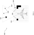
- Figure 5 shows a possible structure 500 for proximity zones which are monitored by the systems 100, 300.
- the environment around the ownship is divided into zones based on proximity to the ownship, in order to aid with data processing and display.
- Different data fusion algorithms are used for different zones, to tailor to the specific characteristics and needs of each zone.
- different sensors are more suitable to different ranges, and thus different zones are associated with different sensor output data.
- Objectives for each zone are appropriately weighted to fuse and prioritise data such that a comprehensive situational awareness of the ownship environment is provided.
- the data fusion techniques allow the aircraft to track any one object as the object moves through different proximity zones.
- the information provided by the system is organised and collected according to a near-field zone 502 and a far-field zone 504. This allows for simpler information density representation management.
- the near-field zone 502 is represented using occupancy grid maps.
- the data fusion algorithms specific to this type of representation are adopted to aggregate the data of detected near-field objects 506 and of detected near-field vehicles 508 within the near-field zone range.
- sensing systems covering the near-field zone provide the position data for the detected near-field objects 506 through an occupancy grid map.
- the data fusion techniques blend the different maps provided by the sensing systems, along with other information such as uncertainty in detection.
- the far-field zone 504 is characterized by sparse detections of detected far-field objects 507, and the detection of detected far-field vehicles 509. Their data is processed using a set of Kalman Filters which provide information and predictions about position and velocity.
- the systems and methods as described herein have the ability to operate as a node in a network of sensors by up-linking localized threat information to an external surveillance service.
- the systems and methods as described herein provide a multi-sensor solution that uses data fusion techniques to leverage the detection capabilities of different sensing technologies. This assists in overcoming the flaws, such as blind spots and limited fields of view, of solutions based on single sensing technologies.
Landscapes
- Engineering & Computer Science (AREA)
- Physics & Mathematics (AREA)
- General Physics & Mathematics (AREA)
- Aviation & Aerospace Engineering (AREA)
- Remote Sensing (AREA)
- Radar, Positioning & Navigation (AREA)
- Theoretical Computer Science (AREA)
- Biophysics (AREA)
- Software Systems (AREA)
- Evolutionary Computation (AREA)
- General Health & Medical Sciences (AREA)
- Molecular Biology (AREA)
- Computing Systems (AREA)
- General Engineering & Computer Science (AREA)
- Computational Linguistics (AREA)
- Mathematical Physics (AREA)
- Data Mining & Analysis (AREA)
- Biomedical Technology (AREA)
- Artificial Intelligence (AREA)
- Health & Medical Sciences (AREA)
- Life Sciences & Earth Sciences (AREA)
- Electromagnetism (AREA)
- Computer Networks & Wireless Communication (AREA)
- Traffic Control Systems (AREA)
Priority Applications (2)
| Application Number | Priority Date | Filing Date | Title |
|---|---|---|---|
| EP23199905.3A EP4531020A1 (de) | 2023-09-26 | 2023-09-26 | System und verfahren zur hinderniserkennung bei einem flugzeug |
| US18/830,082 US20250111794A1 (en) | 2023-09-26 | 2024-09-10 | System and method for aircraft obstacle detection |
Applications Claiming Priority (1)
| Application Number | Priority Date | Filing Date | Title |
|---|---|---|---|
| EP23199905.3A EP4531020A1 (de) | 2023-09-26 | 2023-09-26 | System und verfahren zur hinderniserkennung bei einem flugzeug |
Publications (1)
| Publication Number | Publication Date |
|---|---|
| EP4531020A1 true EP4531020A1 (de) | 2025-04-02 |
Family
ID=88204383
Family Applications (1)
| Application Number | Title | Priority Date | Filing Date |
|---|---|---|---|
| EP23199905.3A Pending EP4531020A1 (de) | 2023-09-26 | 2023-09-26 | System und verfahren zur hinderniserkennung bei einem flugzeug |
Country Status (2)
| Country | Link |
|---|---|
| US (1) | US20250111794A1 (de) |
| EP (1) | EP4531020A1 (de) |
Families Citing this family (1)
| Publication number | Priority date | Publication date | Assignee | Title |
|---|---|---|---|---|
| US20260045168A1 (en) * | 2024-08-07 | 2026-02-12 | The Boeing Company | Sensing system with multi-sensor fusion |
Citations (3)
| Publication number | Priority date | Publication date | Assignee | Title |
|---|---|---|---|---|
| US20150194060A1 (en) * | 2014-01-07 | 2015-07-09 | Honeywell International Inc. | Enhanced awareness of obstacle proximity |
| US20150194059A1 (en) * | 2014-01-07 | 2015-07-09 | Honeywell International Inc. | Obstacle detection system providing context awareness |
| AU2022220403A1 (en) * | 2021-02-12 | 2023-09-21 | Gu, Dahe DR | Systems and methods for monitoring activities in an aviation environment |
Family Cites Families (9)
| Publication number | Priority date | Publication date | Assignee | Title |
|---|---|---|---|---|
| US9091762B2 (en) * | 2011-10-27 | 2015-07-28 | Gulfstream Aerospace Corporation | Methods and systems for avoiding a collision between an aircraft on a ground surface and an obstacle |
| EP2713180B1 (de) * | 2012-09-27 | 2019-04-03 | Honeywell International Inc. | Systeme und Verfahren zur Durchführung einer Fahrzeugkollisionsvermeidungswarnung mittels Sensorimpuls |
| US11928976B2 (en) * | 2019-03-27 | 2024-03-12 | Reliable Robotics Corporation | Cross-checking localization during aircraft terminal operations |
| US11475779B2 (en) * | 2019-10-08 | 2022-10-18 | The Boeing Company | System and method for clearance-based taxi route execution |
| US11908336B2 (en) * | 2019-11-04 | 2024-02-20 | The Boeing Company | System and method for clearance-based taxi route planning |
| US11594144B2 (en) * | 2020-01-31 | 2023-02-28 | Honeywell International Inc. | Collision awareness using cameras mounted on a vehicle |
| US12087169B2 (en) * | 2020-03-04 | 2024-09-10 | Honeywell International Inc. | Methods and systems for highlighting ground traffic on cockpit displays |
| US12272257B2 (en) * | 2022-10-28 | 2025-04-08 | The Boeing Company | Systems and methods for automated aircraft taxiing |
| US12187187B1 (en) * | 2023-08-16 | 2025-01-07 | Nvidia Corporation | Scene illumination detection for autonomous systems and applications |
-
2023
- 2023-09-26 EP EP23199905.3A patent/EP4531020A1/de active Pending
-
2024
- 2024-09-10 US US18/830,082 patent/US20250111794A1/en active Pending
Patent Citations (3)
| Publication number | Priority date | Publication date | Assignee | Title |
|---|---|---|---|---|
| US20150194060A1 (en) * | 2014-01-07 | 2015-07-09 | Honeywell International Inc. | Enhanced awareness of obstacle proximity |
| US20150194059A1 (en) * | 2014-01-07 | 2015-07-09 | Honeywell International Inc. | Obstacle detection system providing context awareness |
| AU2022220403A1 (en) * | 2021-02-12 | 2023-09-21 | Gu, Dahe DR | Systems and methods for monitoring activities in an aviation environment |
Also Published As
| Publication number | Publication date |
|---|---|
| US20250111794A1 (en) | 2025-04-03 |
Similar Documents
| Publication | Publication Date | Title |
|---|---|---|
| CN104272364B (zh) | 飞行器避让方法以及提供有用于实现所述方法的系统的无人机 | |
| US11037453B2 (en) | Adaptive sense and avoid system | |
| US12067889B2 (en) | Systems and methods for detect and avoid system for beyond visual line of sight operations of urban air mobility in airspace | |
| US10424206B2 (en) | Aircraft collision warning | |
| Schönefeld et al. | Runway incursion prevention systems: A review of runway incursion avoidance and alerting system approaches | |
| CN105280025B (zh) | 用于提供供机场离场和到达程序使用的飞行器显示的飞行器显示系统和方法 | |
| EP3832348B1 (de) | Systeme und verfahren für erhöhtes bewusstsein der nähe eines hindernisses bei rollfeldoperationen | |
| EP3043331A2 (de) | Flughafenoberflächenüberwachungssystem mit drahtlosnetzwerkschnittstelle zu luftfahrzeugoberflächennavigationssystem | |
| US11361668B1 (en) | Collision awareness system for ground operations | |
| US8400347B2 (en) | Device and method for monitoring the location of aircraft on the ground | |
| US10140876B2 (en) | Systems and methods for enhanced awareness of obstacle proximity during taxi operations | |
| US11763555B2 (en) | System and method for ground obstacle detection and database management | |
| CN111540238A (zh) | 基于至少呼叫(squawk)代码来识别、描绘和警告遇险和特殊交通的系统和方法 | |
| US20250111794A1 (en) | System and method for aircraft obstacle detection | |
| US9666080B2 (en) | Systems and methods for displaying degraded intruder traffic data on an aircraft display | |
| EP3862999A1 (de) | Landebahnbestimmung basierend auf einer vom flugverkehrsleitsystem empfangenen freigabe | |
| KR101277285B1 (ko) | 데이터 퓨전 시스템 및 방법 | |
| EP3767230B1 (de) | Verfahren und system zur anzeige von objektstandorten während einer such- und rettungsoperation | |
| EP4485426A1 (de) | Fahrzeugverkehrswarnsystem | |
| Le Tallec et al. | Low level rpas traffic management (llrtm) concept of operation | |
| CN109656496A (zh) | 提供基于优先方案的垂直情况显示器对象与横向地图显示器上显示的对象的情境自关联方法 | |
| CN118984512A (zh) | 机场照明控制方法及系统 | |
| Asmat et al. | UAS safety: unmanned aerial collision avoidance system (UCAS) | |
| EP4080482A1 (de) | System und verfahren zur hinderniserkennung und datenbankverwaltung | |
| EP4648034A1 (de) | Integrierte sicherheitswarnung für landebahn |
Legal Events
| Date | Code | Title | Description |
|---|---|---|---|
| PUAI | Public reference made under article 153(3) epc to a published international application that has entered the european phase |
Free format text: ORIGINAL CODE: 0009012 |
|
| STAA | Information on the status of an ep patent application or granted ep patent |
Free format text: STATUS: THE APPLICATION HAS BEEN PUBLISHED |
|
| AK | Designated contracting states |
Kind code of ref document: A1 Designated state(s): AL AT BE BG CH CY CZ DE DK EE ES FI FR GB GR HR HU IE IS IT LI LT LU LV MC ME MK MT NL NO PL PT RO RS SE SI SK SM TR |
|
| STAA | Information on the status of an ep patent application or granted ep patent |
Free format text: STATUS: REQUEST FOR EXAMINATION WAS MADE |
|
| 17P | Request for examination filed |
Effective date: 20251002 |