EP4535232A1 - Auf maschinenlernen basierende routenplanung - Google Patents
Auf maschinenlernen basierende routenplanung Download PDFInfo
- Publication number
- EP4535232A1 EP4535232A1 EP24187151.6A EP24187151A EP4535232A1 EP 4535232 A1 EP4535232 A1 EP 4535232A1 EP 24187151 A EP24187151 A EP 24187151A EP 4535232 A1 EP4535232 A1 EP 4535232A1
- Authority
- EP
- European Patent Office
- Prior art keywords
- information
- initial
- computing system
- machine
- routing information
- Prior art date
- Legal status (The legal status is an assumption and is not a legal conclusion. Google has not performed a legal analysis and makes no representation as to the accuracy of the status listed.)
- Pending
Links
Images


Classifications
-
- G—PHYSICS
- G06—COMPUTING OR CALCULATING; COUNTING
- G06N—COMPUTING ARRANGEMENTS BASED ON SPECIFIC COMPUTATIONAL MODELS
- G06N3/00—Computing arrangements based on biological models
- G06N3/02—Neural networks
- G06N3/04—Architecture, e.g. interconnection topology
- G06N3/044—Recurrent networks, e.g. Hopfield networks
- G06N3/0442—Recurrent networks, e.g. Hopfield networks characterised by memory or gating, e.g. long short-term memory [LSTM] or gated recurrent units [GRU]
-
- G—PHYSICS
- G06—COMPUTING OR CALCULATING; COUNTING
- G06Q—INFORMATION AND COMMUNICATION TECHNOLOGY [ICT] SPECIALLY ADAPTED FOR ADMINISTRATIVE, COMMERCIAL, FINANCIAL, MANAGERIAL OR SUPERVISORY PURPOSES; SYSTEMS OR METHODS SPECIALLY ADAPTED FOR ADMINISTRATIVE, COMMERCIAL, FINANCIAL, MANAGERIAL OR SUPERVISORY PURPOSES, NOT OTHERWISE PROVIDED FOR
- G06Q10/00—Administration; Management
- G06Q10/04—Forecasting or optimisation specially adapted for administrative or management purposes, e.g. linear programming or "cutting stock problem"
- G06Q10/047—Optimisation of routes or paths, e.g. travelling salesman problem
-
- G—PHYSICS
- G05—CONTROLLING; REGULATING
- G05D—SYSTEMS FOR CONTROLLING OR REGULATING NON-ELECTRIC VARIABLES
- G05D1/00—Control of position, course, altitude or attitude of land, water, air or space vehicles, e.g. using automatic pilots
- G05D1/60—Intended control result
- G05D1/648—Performing a task within a working area or space, e.g. cleaning
-
- G—PHYSICS
- G06—COMPUTING OR CALCULATING; COUNTING
- G06N—COMPUTING ARRANGEMENTS BASED ON SPECIFIC COMPUTATIONAL MODELS
- G06N20/00—Machine learning
-
- G—PHYSICS
- G06—COMPUTING OR CALCULATING; COUNTING
- G06N—COMPUTING ARRANGEMENTS BASED ON SPECIFIC COMPUTATIONAL MODELS
- G06N3/00—Computing arrangements based on biological models
- G06N3/02—Neural networks
- G06N3/04—Architecture, e.g. interconnection topology
- G06N3/045—Combinations of networks
-
- G—PHYSICS
- G06—COMPUTING OR CALCULATING; COUNTING
- G06Q—INFORMATION AND COMMUNICATION TECHNOLOGY [ICT] SPECIALLY ADAPTED FOR ADMINISTRATIVE, COMMERCIAL, FINANCIAL, MANAGERIAL OR SUPERVISORY PURPOSES; SYSTEMS OR METHODS SPECIALLY ADAPTED FOR ADMINISTRATIVE, COMMERCIAL, FINANCIAL, MANAGERIAL OR SUPERVISORY PURPOSES, NOT OTHERWISE PROVIDED FOR
- G06Q50/00—Information and communication technology [ICT] specially adapted for implementation of business processes of specific business sectors, e.g. utilities or tourism
- G06Q50/02—Agriculture; Fishing; Forestry; Mining
-
- A—HUMAN NECESSITIES
- A01—AGRICULTURE; FORESTRY; ANIMAL HUSBANDRY; HUNTING; TRAPPING; FISHING
- A01B—SOIL WORKING IN AGRICULTURE OR FORESTRY; PARTS, DETAILS, OR ACCESSORIES OF AGRICULTURAL MACHINES OR IMPLEMENTS, IN GENERAL
- A01B69/00—Steering of agricultural machines or implements; Guiding agricultural machines or implements on a desired track
- A01B69/007—Steering or guiding of agricultural vehicles, e.g. steering of the tractor to keep the plough in the furrow
- A01B69/008—Steering or guiding of agricultural vehicles, e.g. steering of the tractor to keep the plough in the furrow automatic
-
- G—PHYSICS
- G05—CONTROLLING; REGULATING
- G05D—SYSTEMS FOR CONTROLLING OR REGULATING NON-ELECTRIC VARIABLES
- G05D2101/00—Details of software or hardware architectures used for the control of position
- G05D2101/10—Details of software or hardware architectures used for the control of position using artificial intelligence [AI] techniques
- G05D2101/15—Details of software or hardware architectures used for the control of position using artificial intelligence [AI] techniques using machine learning, e.g. neural networks
-
- G—PHYSICS
- G05—CONTROLLING; REGULATING
- G05D—SYSTEMS FOR CONTROLLING OR REGULATING NON-ELECTRIC VARIABLES
- G05D2105/00—Specific applications of the controlled vehicles
- G05D2105/15—Specific applications of the controlled vehicles for harvesting, sowing or mowing in agriculture or forestry
-
- G—PHYSICS
- G05—CONTROLLING; REGULATING
- G05D—SYSTEMS FOR CONTROLLING OR REGULATING NON-ELECTRIC VARIABLES
- G05D2107/00—Specific environments of the controlled vehicles
- G05D2107/20—Land use
- G05D2107/21—Farming, e.g. fields, pastures or barns
-
- G—PHYSICS
- G05—CONTROLLING; REGULATING
- G05D—SYSTEMS FOR CONTROLLING OR REGULATING NON-ELECTRIC VARIABLES
- G05D2109/00—Types of controlled vehicles
- G05D2109/10—Land vehicles
Definitions
- the mobile machines can be or include mobile agricultural machines, mobile construction machines, or mobile forestry machines, for example.
- the techniques disclosed herein provide specific technical solutions to at least overcome the technical problems mentioned in the background section or other parts of the application as well as other technical problems not described herein but recognized by those skilled in the art.
- the techniques include technologies that use machine learning to plan a route. Some embodiments include a method that includes using machine learning to generate or update a route plan. With respect to some embodiments, disclosed herein are computerized methods for using machine learning to plan a route as well as a non-transitory computer-readable storage medium for carrying out technical operations of the computerized methods.
- the non-transitory computer-readable storage medium has tangibly stored thereon, or tangibly encoded thereon, computer-readable instructions that when executed by one or more devices (e.g., one or more personal computers or servers) cause at least one processor to perform a method for improved systems and methods for using machine learning to plan a route.
- the computing system 102 is a part of a mobile machine 110 as are the inputs and outputs of the computing system (including the inputs of the deep learning model 106 and the output of the trained model 107b).
- the computing system 102 and the inputs and outputs of the computing system are part of a remote system in that the remote system is physically and geographically separated from the mobile machine 110 but communicates with a system or controller of the machine over a telecommunications or computer network (such as network 100).
- the mobile machine 110 can be or include an agricultural machine, a construction machine, a forestry machine, or some other type of mobile industrial machine that can be configured to follow routes.
- the network 100 can include one or more local area networks (LAN(s)) and/or one or more wide area networks (WAN(s)).
- the network 100 includes the Internet and/or any other type of interconnected communications network.
- the network 100 can also include a single computer network or a telecommunications network. More specifically, in some embodiments, the network 100 includes a local area network (LAN) such as a private computer network that connects computers in small physical areas, a wide area network (WAN) to connect computers located in different geographical locations, and/or a middle area network (MAN) to connect computers in a geographic area larger than that covered by a large LAN but smaller than the area covered by a WAN.
- LAN local area network
- WAN wide area network
- MAN middle area network
- the data storage system 210 includes a machine-readable storage medium 212 (also known as a computer-readable medium) on which is stored one or more sets of instructions 214 or software embodying any one or more of the methodologies or functions described herein performed by a computing system.
- the instructions 214 also reside, completely or at least partially, within the main memory 204 or within the processing device 202 during execution thereof by the computing system 200, the main memory 204 and the processing device 202 also constituting machine-readable storage media. While the machine-readable storage medium 212 is shown in an example embodiment to be a single medium, the term "machine-readable storage medium" should be taken to include a single medium or multiple media that store the one or more sets of instructions.
- machine-readable storage medium shall also be taken to include any medium that is capable of storing or encoding a set of instructions for execution by the machine and that causes the machine to perform any one or more of the methodologies of the present disclosure performed by a computing system.
- machine-readable storage medium shall accordingly be taken to include solid-state memories, optical media, or magnetic media.
- the computing system 200 includes user interface 216 that includes a display, in some embodiments, and, for example, implements functionality corresponding to any one of the UI devices disclosed herein.
- a UI such as UI 216, or a UI device described herein includes any space or equipment where interactions between humans and machines occur.
- a UI described herein allows operation and control of the machine from a human user, while the machine simultaneously provides feedback information to the user. Examples of a user interface, or UI device include the interactive aspects of computer operating systems (such as GUIs), machinery operator controls, and process controls.
- FIGS. 3 to 12 illustrate methods in accordance with some embodiments of the present disclosure.
- Methods 300, 400, 500, 600, 700, 800, 900, and 1200 of the corresponding figures are performed by any one of the computing systems described herein (e.g., see computing system 102 or 200 depicted in FIGS. 1 and 2 respectively).
- any steps of embodiments of the methods described herein are implementable by executing instructions corresponding to the steps, which are stored in memory (such as the instructions 214).
- step 302 includes receiving, by a computing system (e.g., see computing system 102 or 200 shown in FIG. 1 or 2 respectively), initial routing information (e.g., see initial routing information 104 depicted in FIG. 1 ).
- the initial routing information defines routes followed by or to be followed by one or more mobile machines in one or more fields.
- the one or more mobile machines include one or more agricultural machines.
- the one or more mobile machines include one or more construction machines.
- the one or more mobile machines can include one or more forestry machines such as various types of mobile logging equipment.
- Step 302 can also include or rely on data collection by the computing system or other systems communicatively coupled to the computing system.
- the method 300 can include continuous improvement such as regularly updating the model with new data to ensure its performance remains accurate and up-to-date.
- the improvement can also include monitoring the model's performance and retraining or fine-tuning the model per application of it or as needed.
- step 502 includes controlling a given mobile machine (e.g., see mobile machine 110), by the computing system, to follow routes in a field according to the new routing information.
- step 502 includes communicating, by the computing system, the new routing information or a derivative thereof to an electronic control unit (ECU) of the given mobile machine as well as at least partially controlling, by the ECU, a movement of the given machine according to the new routing information or the derivative thereof.
- ECU electronice control unit
- method 600 begins with step 302 of method 300, which includes the receiving of the initial routing information. And, then continues with step 304, which includes the training of the deep learning model using the initial routing information. Also, as shown, the method 600 starts with step 602, which includes receiving, by the computing system, initial mobile machine information (e.g., see initial mobile machine information 112 depicted in FIG. 1 ). With method 600, at step 604, the method includes further training, by the computing system, the deep learning model according to the initial mobile machine information in addition to the initial routing information. Also, the method 600 can end with step 306 of method 300 (using the trained model to generate new routing information for a given field).
- initial mobile machine information e.g., see initial mobile machine information 112 depicted in FIG. 1
- the method includes further training, by the computing system, the deep learning model according to the initial mobile machine information in addition to the initial routing information.
- the method 600 can end with step 306 of method 300 (using the trained model to generate new routing information for a given field).
- method 800 begins with step 302 of method 300, which includes the receiving of the initial routing information. And, then continues with step 304, which includes the training of the deep learning model using the initial routing information. Also, as shown, the method 800 starts with step 802, which includes receiving, by the computing system, weather data (e.g., see weather data 116 depicted in FIG. 1 ). With method 800, at step 804, the method includes further training, by the computing system, the deep learning model according to the weather data in addition to the initial routing information. Also, the method 600 can end with step 306 of method 300 (using the trained model to generate new routing information for a given field).
- weather data e.g., see weather data 116 depicted in FIG. 1
- the method includes further training, by the computing system, the deep learning model according to the weather data in addition to the initial routing information.
- the method 600 can end with step 306 of method 300 (using the trained model to generate new routing information for a given field).
- the using of the trained model can include associating, by the computing system, the last generated wayline to the set of waylines. Furthermore, the use of the trained model can include determining, by the computing system, whether the set of waylines covers the given field. Also, the use of the trained model can include generating, by the computing system, a new wayline for the set of waylines based on the generated new routing information and the parameters of the last generated wayline, when the set of waylines does not cover the crop field after the lasted generated wayline is generated and associated with the set of waylines. Also, the use of the trained model can include completing generation of the set of waylines, by the computing system, when the set of waylines does cover the field after the last generated wayline is generated and associated with the set of waylines.
- the set of waylines can include an ordered set of waylines.
- the generation of the last generated wayline includes generating, by the computing system, waypoints of the last generated wayline, and wherein the generation of the last generated wayline further includes generating, by the computing system, the wayline through an interpolation based on the generated waypoints.
- step 902 includes receiving, by a computing system, parameters of a predetermined wayline for using a selected mobile machine in a selected field (such as a selected crop field, a selected construction zone, or a selected forestry field or area of a forest).
- the mobile machine can be an agricultural mobile machine, a construction mobile machine, a forestry mobile machine, or another type of mobile machine used for another type of industrial application.
- step 904 includes generating, by the computing system, a last generated wayline for a set of waylines based on the received parameters of predetermined wayline.
- step 906 which includes associating, by the computing system, the last (or a newly) generated wayline to the set.
- the method 900 continues with transmitting, by the computing system, the route to a controller of the mobile machine that controls the steering of the mobile machine based on the route. And, finally, at step 916, the method 900 continues with controlling, by the controller of the mobile machine, the mobile machine according to the route.
- step 904 or 905 can include step 1002, which includes generating waypoints of the way line.
- step 904 or 905 also can include step 1004, which includes generating the wayline through an interpolation based on the generated waypoints.
- step 904 or 905 can include step 1102, which includes generating the wayline further based on a working width of the mobile machine.
- step 904 or 905 also can include step 1104, which includes generating the wayline further based on a turning radius of the mobile machine.
- the method 1200 like method 900, essentially returns to steps 1204, when the set does not cover the field (e.g., see step 1205, wherein the computing system generates a new wayline for the set based on the parameters of the last generated wayline and the radius and the width). And, then step 906, which includes associating the last (or a newly) generated wayline to the set is repeated, and so on. Otherwise, the method 1200 then continues with step 910 (similar to method 900), which includes completing the generation of the set of waylines. And, after the completion of the set, the method 900 continues with generating a route of the mobile machine in the field based on the completed set of waylines (at step 912). And, finally, at step 914, the method 1200 continues with transmitting the route to a controller of the mobile machine, and at step 916, the method 1200 continues with controlling, by the controller of the mobile machine, the mobile machine according to the route.
- step 910 similar to method 900
- the generated waylines of the planning method can be used as guidance for a vehicle with an Ackerman mechanism or another type of steering mechanisms.
- the objective function or cost function
- the following equations are used as bases for cost1, cost2, and cost3 of the objective function.
- each constraint is represented by an s.t. constraint function.
- FIG. 14 illustrates that a straight line is easier to follow than a curved line because it is smoother.
- This notion relates to cost2 (e.g., see Eq. 3).
- Cost2 the plan considers minimizing the total length of a wayline, since a shorter wayline length means a straighter wayline and a straighter wayline means a smoother of the wayline.
- the straight line is easier to follow for a mobile machine than the curved line because it is smoother and will have lesser turning angles.
- FIG. 15 illustrates that skipped areas 1502 in a set of waylines occur and increase in size with greater curve in a preceding wayline, with respect to a new wayline, in accordance with some embodiments of the present disclosure.
- FIG. 16 illustrates an example relationship between a previously generated wayline 1602 and a new wayline 1604 generated based on the previously generated wayline, in accordance with some embodiments of the present disclosure.
- cost3 e.g., see Eq. 4
- the plan considers or uses minimizing the overlapping of adjacent waylines while achieving the goal of reducing skipped area between adjacent waylines.
- s.t.1 and s.t.2 relate to distance constraint for points of adjacent waylines where distance between each pair of point at adjacent waylines only allow between certain conditions (e.g., 0.8*w and 1*w, w is the working width of the machine). For example, see FIGS. 15 and 16 , where it is illustrated that at least two waylines each have multiple waypoints. And, as shown in FIG.
- p_ new i are wayline points generated based on corresponding point p _ref i at the reference (or previous) wayline by using a traditional offset method, at least to some extent, which leads to skipped areas between swaths.
- the constraint for points of adjacent waylines allows the point p _new i to freely move (e.g., search a solution) between a given distance (e.g., the given distance 0.8*w and 1*w) with a goal to reduce the skipped area and at the same time to keep the produced overlap between adjacent waylines as much as possible.
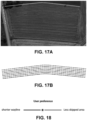
- FIG. 17A illustrates an initial wayline generated for a crop field
- FIG. 17B illustrates additional waylines generated based on the initial wayline according to one or more of the equations provided herein (e.g., equations 1, 2, 3, 4, 5, s.t.1, s.t.2, s.t.3, s.t.4, and s.t.5).
- Waylines generated by such a plan and such equations are shown in FIG. 17B , in which the red line is the one side of the field boundary, see the image shown in FIG. 17A , and is the initial reference wayline and the blue lines are the generated waylines that were generated based on parameters of the initial wayline such as provided by steps 904 and 1204 in methods 900 and 1200 respectively.
- FIG. 18 illustrates an example graphical output having a slider bar for adjusting the parameters of the waylines according to tradeoffs and the output can be a part of a graphical user interface (GUI)-such as a GUI provided by the computing system 200.
- GUI graphical user interface
- the generation of waylines for a set of waylines can be alternatively based on a preference of an operator and the alternative generation of the waylines is selectable by the operator from a user interface (Ul), such as a GUI.
- the UI includes a slider for adjusting the parameters of the waylines according to one or more tradeoffs.
- the UI allows for multiple different selection choices for adjusting the objective function to adjust for different tradeoffs (e.g., adjust for less overlap or skipped area, or straightness of waylines versus skipped area, or less overlap versus straightness of waylines, etc.).
Landscapes
- Engineering & Computer Science (AREA)
- Business, Economics & Management (AREA)
- Theoretical Computer Science (AREA)
- Physics & Mathematics (AREA)
- Human Resources & Organizations (AREA)
- General Physics & Mathematics (AREA)
- Strategic Management (AREA)
- Economics (AREA)
- Software Systems (AREA)
- General Business, Economics & Management (AREA)
- Tourism & Hospitality (AREA)
- Marketing (AREA)
- General Engineering & Computer Science (AREA)
- Artificial Intelligence (AREA)
- Health & Medical Sciences (AREA)
- General Health & Medical Sciences (AREA)
- Mathematical Physics (AREA)
- Computing Systems (AREA)
- Evolutionary Computation (AREA)
- Data Mining & Analysis (AREA)
- Life Sciences & Earth Sciences (AREA)
- Entrepreneurship & Innovation (AREA)
- Development Economics (AREA)
- Quality & Reliability (AREA)
- Operations Research (AREA)
- Game Theory and Decision Science (AREA)
- Biomedical Technology (AREA)
- Biophysics (AREA)
- Molecular Biology (AREA)
- Computational Linguistics (AREA)
- Marine Sciences & Fisheries (AREA)
- Medical Informatics (AREA)
- Primary Health Care (AREA)
- Agronomy & Crop Science (AREA)
- Mining & Mineral Resources (AREA)
- Computer Vision & Pattern Recognition (AREA)
- Animal Husbandry (AREA)
- Automation & Control Theory (AREA)
- Remote Sensing (AREA)
- Aviation & Aerospace Engineering (AREA)
Applications Claiming Priority (1)
| Application Number | Priority Date | Filing Date | Title |
|---|---|---|---|
| US202363588212P | 2023-10-05 | 2023-10-05 |
Publications (1)
| Publication Number | Publication Date |
|---|---|
| EP4535232A1 true EP4535232A1 (de) | 2025-04-09 |
Family
ID=91898081
Family Applications (1)
| Application Number | Title | Priority Date | Filing Date |
|---|---|---|---|
| EP24187151.6A Pending EP4535232A1 (de) | 2023-10-05 | 2024-07-08 | Auf maschinenlernen basierende routenplanung |
Country Status (2)
| Country | Link |
|---|---|
| US (1) | US20250117719A1 (de) |
| EP (1) | EP4535232A1 (de) |
Citations (1)
| Publication number | Priority date | Publication date | Assignee | Title |
|---|---|---|---|---|
| US20230232731A1 (en) * | 2022-01-21 | 2023-07-27 | Deere & Company | Controlling an agricultural vehicle based on soil damage score |
Family Cites Families (13)
| Publication number | Priority date | Publication date | Assignee | Title |
|---|---|---|---|---|
| US10378896B2 (en) * | 2006-02-27 | 2019-08-13 | Trimble Inc. | Method and system for planning the path of an agricultural vehicle |
| JP6727944B2 (ja) * | 2016-06-17 | 2020-07-22 | 株式会社クボタ | 圃場走行経路生成システム及び圃場作業車 |
| JP6872911B2 (ja) * | 2017-01-20 | 2021-05-19 | 株式会社クボタ | 走行経路生成装置 |
| US10621448B2 (en) * | 2017-08-02 | 2020-04-14 | Wing Aviation Llc | Systems and methods for determining path confidence for unmanned vehicles |
| US12585275B1 (en) * | 2018-06-13 | 2026-03-24 | Nvidia Corporation | Loss scaling for neural networks |
| AU2019380955B2 (en) * | 2018-11-15 | 2023-02-09 | Raven Industries, Inc. | Integrated platform and common software structural architecture for autonomous agricultural vehicle and machinery operation. |
| US20210003416A1 (en) * | 2019-07-03 | 2021-01-07 | Ag Leader Technology | Apparatus, Systems And Methods For Automatic Steering Guidance And Visualization Of Guidance Paths |
| CN111982137B (zh) * | 2020-06-30 | 2022-08-12 | 阿波罗智能技术(北京)有限公司 | 生成路线规划模型的方法、装置、设备和存储介质 |
| US12110007B2 (en) * | 2022-01-21 | 2024-10-08 | Deere & Company | Detection and control based on soil damage |
| CA3255852A1 (en) * | 2022-04-29 | 2023-11-02 | Carbon Autonomous Robotic Systems Inc. | SYSTEM AND METHOD FOR AUTONOMOUS NAVIGATION IN A FIELD |
| US12466432B2 (en) * | 2022-05-09 | 2025-11-11 | Waymo Llc | Autonomous vehicle driving path label generation for machine learning models |
| GB202216301D0 (en) * | 2022-11-02 | 2022-12-14 | Agco Int Gmbh | Path planning for an agricultural field based on end of swath detection |
| EP4535119A1 (de) * | 2023-10-05 | 2025-04-09 | AGCO International GmbH | Auf maschinenlernen basierende steuerung und umleitung |
-
2024
- 2024-07-08 EP EP24187151.6A patent/EP4535232A1/de active Pending
- 2024-07-17 US US18/775,537 patent/US20250117719A1/en active Pending
Patent Citations (1)
| Publication number | Priority date | Publication date | Assignee | Title |
|---|---|---|---|---|
| US20230232731A1 (en) * | 2022-01-21 | 2023-07-27 | Deere & Company | Controlling an agricultural vehicle based on soil damage score |
Non-Patent Citations (1)
| Title |
|---|
| TORMAGOV TIMOFEY ET AL: "Coverage Path Planning for 3D Terrain with Constraints on Trajectory Curvature Based on Second-Order Cone Programming", ADVANCES IN OPTIMIZATION AND APPLICATIONS : 12TH INTERNATIONAL CONFERENCE, OPTIMA 2021, PETROVAC, MONTENEGRO, SEPTEMBER 27 - OCTOBER 1, 2021, vol. 1514, 9 December 2021 (2021-12-09), pages 258 - 272, XP093223453, ISBN: 978-3-030-92710-3, Retrieved from the Internet <URL:https://ebookcentral.proquest.com/lib/epo-ebooks/detail.action?docID=6824256> DOI: 10.1007/978-3-030-92711-0_18 * |
Also Published As
| Publication number | Publication date |
|---|---|
| US20250117719A1 (en) | 2025-04-10 |
Similar Documents
| Publication | Publication Date | Title |
|---|---|---|
| EP4535119A1 (de) | Auf maschinenlernen basierende steuerung und umleitung | |
| US20260073401A1 (en) | Autonomous landscaping system | |
| EP3881151B1 (de) | Integrierte plattform und gemeinsame software-architektur für den betrieb autonomer landwirtschaftlicher fahrzeuge und maschinen | |
| EP4352457B1 (de) | Führungssystem zur navigation durch zwischenliegende hindernisse und verfahren dafür | |
| EP3629693B1 (de) | Verfahren zur steuerung einer bodenbearbeitungsvorrichtung auf der basis von bildverarbeitung und diesbezügliches system | |
| Bochtis et al. | Route planning for orchard operations | |
| US11175374B2 (en) | Location estimation apparatus, moving object, location estimation method, and computer readable storage medium | |
| US12298775B2 (en) | Coverage planner | |
| KR102340543B1 (ko) | 부착형 농작업 경로 인식 장치 | |
| US20200375098A1 (en) | Information processing apparatus, information processing method, and computer readable storage medium | |
| Mengoli et al. | Autonomous robotic platform for precision orchard management: Architecture and software perspective | |
| Celenta et al. | Retrofitting techniques for agricultural machines | |
| WO2019167207A1 (ja) | 制御装置、作業機及びプログラム | |
| CN118092290B (zh) | 基于路径规划的多种植车辆协同控制系统 | |
| EP4535232A1 (de) | Auf maschinenlernen basierende routenplanung | |
| Chatzisavvas et al. | Autonomous unmanned ground vehicle in precision agriculture–the velos project | |
| US20250040463A1 (en) | Operational Path Planning | |
| CN117148857A (zh) | 一种应用于复杂环境检测的无人机路径规划巡检方法 | |
| US12557724B2 (en) | Map based farming for windrower operation | |
| CN119723488B (zh) | 萝卜无人化收获系统 | |
| KR102666421B1 (ko) | 농기계의 작업범위 및 작업시간 최적화 시스템 | |
| US20250390808A1 (en) | Model-Based Route Planning and Graphical User Interfaces for the Planning | |
| US20250116974A1 (en) | Machine Learning Based Machine Settings Enhancement | |
| US20250370454A1 (en) | Guiding an Agricultural Vehicle Using Reinforcement Learning | |
| Jelavic | Hybrid Motion Planning and Control for Legged-Wheeled Robots: Application to Walking Excavators |
Legal Events
| Date | Code | Title | Description |
|---|---|---|---|
| PUAI | Public reference made under article 153(3) epc to a published international application that has entered the european phase |
Free format text: ORIGINAL CODE: 0009012 |
|
| STAA | Information on the status of an ep patent application or granted ep patent |
Free format text: STATUS: THE APPLICATION HAS BEEN PUBLISHED |
|
| AK | Designated contracting states |
Kind code of ref document: A1 Designated state(s): AL AT BE BG CH CY CZ DE DK EE ES FI FR GB GR HR HU IE IS IT LI LT LU LV MC ME MK MT NL NO PL PT RO RS SE SI SK SM TR |
|
| STAA | Information on the status of an ep patent application or granted ep patent |
Free format text: STATUS: REQUEST FOR EXAMINATION WAS MADE |
|
| 17P | Request for examination filed |
Effective date: 20251009 |