EP4571366A1 - System und verfahren zur erzeugung von seismischen daten hoher qualität aus seismischen daten niedriger qualität - Google Patents
System und verfahren zur erzeugung von seismischen daten hoher qualität aus seismischen daten niedriger qualität Download PDFInfo
- Publication number
- EP4571366A1 EP4571366A1 EP24219526.1A EP24219526A EP4571366A1 EP 4571366 A1 EP4571366 A1 EP 4571366A1 EP 24219526 A EP24219526 A EP 24219526A EP 4571366 A1 EP4571366 A1 EP 4571366A1
- Authority
- EP
- European Patent Office
- Prior art keywords
- dataset
- data
- processed data
- processing technique
- machine learning
- Prior art date
- Legal status (The legal status is an assumption and is not a legal conclusion. Google has not performed a legal analysis and makes no representation as to the accuracy of the status listed.)
- Pending
Links
Images



Classifications
-
- G—PHYSICS
- G01—MEASURING; TESTING
- G01V—GEOPHYSICS; GRAVITATIONAL MEASUREMENTS; DETECTING MASSES OR OBJECTS; TAGS
- G01V1/00—Seismology; Seismic or acoustic prospecting or detecting
- G01V1/28—Processing seismic data, e.g. for interpretation or for event detection
-
- G—PHYSICS
- G06—COMPUTING OR CALCULATING; COUNTING
- G06F—ELECTRIC DIGITAL DATA PROCESSING
- G06F16/00—Information retrieval; Database structures therefor; File system structures therefor
- G06F16/20—Information retrieval; Database structures therefor; File system structures therefor of structured data, e.g. relational data
- G06F16/21—Design, administration or maintenance of databases
- G06F16/215—Improving data quality; Data cleansing, e.g. de-duplication, removing invalid entries or correcting typographical errors
-
- G—PHYSICS
- G01—MEASURING; TESTING
- G01V—GEOPHYSICS; GRAVITATIONAL MEASUREMENTS; DETECTING MASSES OR OBJECTS; TAGS
- G01V1/00—Seismology; Seismic or acoustic prospecting or detecting
- G01V1/28—Processing seismic data, e.g. for interpretation or for event detection
- G01V1/30—Analysis
- G01V1/301—Analysis for determining seismic cross-sections or geostructures
-
- G—PHYSICS
- G06—COMPUTING OR CALCULATING; COUNTING
- G06F—ELECTRIC DIGITAL DATA PROCESSING
- G06F16/00—Information retrieval; Database structures therefor; File system structures therefor
- G06F16/20—Information retrieval; Database structures therefor; File system structures therefor of structured data, e.g. relational data
- G06F16/25—Integrating or interfacing systems involving database management systems
- G06F16/258—Data format conversion from or to a database
Definitions
- Seismic data processing is divided into multiple stages.
- the first stage referred to herein interchangeably as fast-track processing, uses a type of processing that produces approximated images of the subsurface relatively quickly compared to the second stage, referred to herein interchangeably as full-track processing.
- the issues that the data exhibit are evaluated, and types of processing tools that can be used to optimize signal quality are found.
- Information from the first stage is used in the second stage to produce more reliable and optimal results compared to results from the first stage.
- Seismic data processing often involves various steps such as denoising, deblending, interpolation, deconvolution, demultiple, and/or deghosting before data are ready for imaging or inversion.
- the selection of processing technology depends upon cost and computing time factors, as well as generating the best possible results in a relatively limited time compared to the second stage.
- the cost factor increases in importance relative to the computing time factor when processing large-scale seismic data volumes to perform subsurface interpretation quickly.
- the quality of the results from processing depends upon the way seismic data are acquired, for example, how the data are sampled and received in the field.
- Cost and computing time factors during the first stage can dictate the choice of a processing technology, sometimes at the expense of quality of the result compared to the quality of the result after second stage processing. How the signal quality that results from processing in the first stage can be improved without increasing the turnaround time has been studied.
- a generative adversarial network has been used to interpolate seismic data, and compared to the quality of the results from physics-driven deterministic methods.
- the physics-driven priors can be included in the GAN architecture, but possibly negating the purpose of developing and using a machine learning architecture.
- a method for generating high-quality seismic data includes receiving a first dataset.
- the method also includes selecting a first processing technique based upon the first dataset.
- the method also includes producing first processed data from the first dataset using the first processing technique.
- the method also includes selecting a second processing technique based upon the first dataset.
- the second processing technique is different than the first processing technique.
- the method also includes producing second processed data from the first dataset using the second processing technique.
- the method also includes training a machine learning model to transform the first processed data into the second processed data.
- a computing system includes one or more processors and a memory system including one or more non-transitory computer-readable media storing instructions that, when executed by at least one of the one or more processors, cause the computing system to perform operations.
- the operations include receiving a first dataset.
- the first dataset includes seismic data that represents a subsurface.
- the operations also include selecting a first processing technique based upon the first dataset.
- the operations also include producing first processed data from the first dataset using the first processing technique.
- the first processed data has a higher quality than the first dataset.
- the operations also include selecting a second processing technique based upon the first dataset.
- the second processing technique is different than the first processing technique.
- the operations also include producing second processed data from the first dataset using the second processing technique.
- the second processed data has a higher quality than the first dataset and the first processed data.
- the operations also include training a machine learning model to transform the first processed data into the second processed data.
- the operations also include receiving a second dataset.
- the operations also include transforming the second dataset into a third dataset using the trained machine learning model.
- the third dataset has a higher quality than the first dataset and the second dataset.
- a non-transitory computer-readable medium stores instructions for autonomously performing a subsurface operation that, when executed by one or more processors of a computing system, cause the computing system to perform operations.
- the operations include receiving a first dataset.
- the first dataset includes seismic data that represents a subsurface.
- the seismic data is from a land or marine environment.
- the seismic data includes particle data.
- the particle data includes particle displacement data, particle velocity data, particle acceleration data, or a combination thereof.
- the operations also include selecting a first processing technique based upon the first dataset.
- the first processing technique includes denoising, deblending, interpolating, deconvoluting, demultiple, deghosting, imaging, inversion, residual moveout correction (RMO), noise suppression, regularization, or a combination thereof.
- the operations also include producing first processed data from the first dataset using the first processing technique.
- the first processed data has a higher quality than the first dataset.
- the operations also include selecting a second processing technique based upon the first dataset.
- the second processing technique includes denoising, deblending, interpolating, deconvoluting, demultiple, deghosting, imaging, inversion, RMO, noise suppression, regularization, or a combination thereof.
- the second processing technique is different than the first processing technique.
- the operations also include producing second processed data from the first dataset using the second processing technique.
- the second processed data has a higher quality than the first dataset and the first processed data.
- the operations also include training a machine learning model to transform the first processed data into the second processed data.
- the machine learning model includes a generative adversarial network, a variational autoencoder, a diffusion model, a transformer, a neural radiance field, a convolution-based model, a non-convolution-based model, or a combination thereof.
- Training includes or generates a generator loss function, a discriminator loss function, an adversarial loss function, or a combination thereof.
- the operations also include receiving a second dataset.
- the operations also include transforming the second dataset into a third dataset using the trained machine learning model.
- the third dataset has a higher quality than the first dataset and the second dataset.
- the operations also include displaying the third dataset.
- first, second, etc. may be used herein to describe various elements, these elements should not be limited by these terms. These terms are only used to distinguish one element from another.
- a first object or step could be termed a second object or step, and, similarly, a second object or step could be termed a first object or step, without departing from the scope of the present disclosure.
- the first object or step, and the second object or step are both, objects or steps, respectively, but they are not to be considered the same object or step.
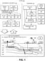
- Figure 1 illustrates an example of a system 100 that includes various management components 110 to manage various aspects of a geologic environment 150 (e.g., an environment that includes a sedimentary basin, a reservoir 151, one or more faults 153-1, one or more geobodies 153-2, etc.).
- the management components 110 may allow for direct or indirect management of sensing, drilling, injecting, extracting, etc., with respect to the geologic environment 150.
- further information about the geologic environment 150 may become available as feedback 160 (e.g., optionally as input to one or more of the management components 110).
- the management components 110 include a seismic data component 112, an additional information component 114 (e.g., well/logging data), a processing component 116, a simulation component 120, an attribute component 130, an analysis/visualization component 142 and a workflow component 144.
- seismic data and other information provided per the components 112 and 114 may be input to the simulation component 120.
- the simulation component 120 may rely on entities 122.
- Entities 122 may include earth entities or geological objects such as wells, surfaces, bodies, reservoirs, etc.
- the entities 122 can include virtual representations of actual physical entities that are reconstructed for purposes of simulation.
- the entities 122 may include entities based on data acquired via sensing, observation, etc. (e.g., the seismic data 112 and other information 114).
- An entity may be characterized by one or more properties (e.g., a geometrical pillar grid entity of an earth model may be characterized by a porosity property). Such properties may represent one or more measurements (e.g., acquired data), calculations, etc.
- the simulation component 120 may operate in conjunction with a software framework such as an object-based framework.
- entities may include entities based on pre-defined classes to facilitate modeling and simulation.
- object-based framework is the MICROSOFT ® .NET ® framework (Redmond, Washington), which provides a set of extensible object classes.
- .NET ® framework an object class encapsulates a module of reusable code and associated data structures.
- Object classes can be used to instantiate object instances for use in by a program, script, etc.
- borehole classes may define objects for representing boreholes based on well data.
- the simulation component 120 may process information to conform to one or more attributes specified by the attribute component 130, which may include a library of attributes. Such processing may occur prior to input to the simulation component 120 (e.g., consider the processing component 116). As an example, the simulation component 120 may perform operations on input information based on one or more attributes specified by the attribute component 130. In an example embodiment, the simulation component 120 may construct one or more models of the geologic environment 150, which may be relied on to simulate behavior of the geologic environment 150 (e.g., responsive to one or more acts, whether natural or artificial). In the example of Figure 1 , the analysis/visualization component 142 may allow for interaction with a model or model-based results (e.g., simulation results, etc.). As an example, output from the simulation component 120 may be input to one or more other workflows, as indicated by a workflow component 144.
- a workflow component 144 may process information to conform to one or more attributes specified by the attribute component 130, which may include a library of attributes. Such processing may occur prior to input to the simulation
- the simulation component 120 may include one or more features of a simulator such as the ECLIPSE TM reservoir simulator (Schlumberger Limited, Houston Texas), the INTERSECT TM reservoir simulator (Schlumberger Limited, Houston Texas), etc.
- a simulation component, a simulator, etc. may include features to implement one or more meshless techniques (e.g., to solve one or more equations, etc.).
- a reservoir or reservoirs may be simulated with respect to one or more enhanced recovery techniques (e.g., consider a thermal process such as SAGD, etc.).
- the management components 110 may include features of a commercially available framework such as the PETREL ® seismic to simulation software framework (Schlumberger Limited, Houston, Texas).
- the PETREL ® framework provides components that allow for optimization of exploration and development operations.
- the PETREL ® framework includes seismic to simulation software components that can output information for use in increasing reservoir performance, for example, by improving asset team productivity.
- various professionals e.g., geophysicists, geologists, and reservoir engineers
- Such a framework may be considered an application and may be considered a data-driven application (e.g., where data is input for purposes of modeling, simulating, etc.).
- various aspects of the management components 110 may include add-ons or plug-ins that operate according to specifications of a framework environment.
- a framework environment e.g., a commercially available framework environment marketed as the OCEAN ® framework environment (Schlumberger Limited, Houston, Texas) allows for integration of add-ons (or plug-ins) into a PETREL ® framework workflow.
- the OCEAN ® framework environment leverages .NET ® tools (Microsoft Corporation, Redmond, Washington) and offers stable, user-friendly interfaces for efficient development.
- various components may be implemented as add-ons (or plug-ins) that conform to and operate according to specifications of a framework environment (e.g., according to application programming interface (API) specifications, etc.).
- API application programming interface
- Figure 1 also shows an example of a framework 170 that includes a model simulation layer 180 along with a framework services layer 190, a framework core layer 195 and a modules layer 175.
- the framework 170 may include the commercially available OCEAN ® framework where the model simulation layer 180 is the commercially available PETREL ® model-centric software package that hosts OCEAN ® framework applications.
- the PETREL ® software may be considered a data-driven application.
- the PETREL ® software can include a framework for model building and visualization.
- a framework may include features for implementing one or more mesh generation techniques.
- a framework may include an input component for receipt of information from interpretation of seismic data, one or more attributes based at least in part on seismic data, log data, image data, etc.
- Such a framework may include a mesh generation component that processes input information, optionally in conjunction with other information, to generate a mesh.
- the model simulation layer 180 may provide domain objects 182, act as a data source 184, provide for rendering 186 and provide for various user interfaces 188.
- Rendering 186 may provide a graphical environment in which applications can display their data while the user interfaces 188 may provide a common look and feel for application user interface components.
- the domain objects 182 can include entity objects, property objects and optionally other objects.
- Entity objects may be used to geometrically represent wells, surfaces, bodies, reservoirs, etc.
- property objects may be used to provide property values as well as data versions and display parameters.
- an entity object may represent a well where a property object provides log information as well as version information and display information (e.g., to display the well as part of a model).
- data may be stored in one or more data sources (or data stores, generally physical data storage devices), which may be at the same or different physical sites and accessible via one or more networks.
- the model simulation layer 180 may be configured to model projects. As such, a particular project may be stored where stored project information may include inputs, models, results and cases. Thus, upon completion of a modeling session, a user may store a project. At a later time, the project can be accessed and restored using the model simulation layer 180, which can recreate instances of the relevant domain objects.
- the geologic environment 150 may include layers (e.g., stratification) that include a reservoir 151 and one or more other features such as the fault 153-1, the geobody 153-2, etc.
- the geologic environment 150 may be outfitted with any of a variety of sensors, detectors, actuators, etc.
- equipment 152 may include communication circuitry to receive and to transmit information with respect to one or more networks 155.
- Such information may include information associated with downhole equipment 154, which may be equipment to acquire information, to assist with resource recovery, etc.
- Other equipment 156 may be located remote from a well site and include sensing, detecting, emitting or other circuitry.
- Such equipment may include storage and communication circuitry to store and to communicate data, instructions, etc.
- one or more satellites may be provided for purposes of communications, data acquisition, etc.
- Figure 1 shows a satellite in communication with the network 155 that may be configured for communications, noting that the satellite may additionally or instead include circuitry for imagery (e.g., spatial, spectral, temporal, radiometric, etc.).
- imagery e.g., spatial, spectral, temporal, radiometric, etc.
- Figure 1 also shows the geologic environment 150 as optionally including equipment 157 and 158 associated with a well that includes a substantially horizontal portion that may intersect with one or more fractures 159.
- equipment 157 and 158 associated with a well that includes a substantially horizontal portion that may intersect with one or more fractures 159.
- a well in a shale formation may include natural fractures, artificial fractures (e.g., hydraulic fractures) or a combination of natural and artificial fractures.
- a well may be drilled for a reservoir that is laterally extensive.
- lateral variations in properties, stresses, etc. may exist where an assessment of such variations may assist with planning, operations, etc. to develop a laterally extensive reservoir (e.g., via fracturing, injecting, extracting, etc.).
- the equipment 157 and/or 158 may include components, a system, systems, etc. for fracturing, seismic sensing, analysis of seismic data, assessment of one or more fractures, etc.
- a workflow may be a process that includes a number of worksteps.
- a workstep may operate on data, for example, to create new data, to update existing data, etc.
- a may operate on one or more inputs and create one or more results, for example, based on one or more algorithms.
- a system may include a workflow editor for creation, editing, executing, etc. of a workflow.
- the workflow editor may provide for selection of one or more pre-defined worksteps, one or more customized worksteps, etc.
- a workflow may be a workflow implementable in the PETREL ® software, for example, that operates on seismic data, seismic attribute(s), etc.
- a workflow may be a process implementable in the OCEAN ® framework.
- a workflow may include one or more worksteps that access a module such as a plug-in (e.g., external executable code, etc.).
- a method in accordance with the present disclosure includes selecting a sample of seismic data for an area, and subjecting the sample to both fast-track processing techniques and full-track processing techniques.
- the method further includes training a neural network using the fast-track and full-track processed samples. Once trained, the neural network may produce results that would be obtained from full-track processing based on data provided to the neural network that had undergone fast-track processing.
- the method still further includes receiving seismic data, providing the data to the trained neural network, obtaining results from the neural network, and providing the results to a user.
- An example of the type of processing in both fast-track and full-track processing is data interpolation.
- a fast-track interpolation technique can produce results, for example, but not limited to, images, that exhibit lower resolution and lower quality than a full-track interpolation technique.
- a neural network for example, but not limited to, a GAN-based machine learning architecture, can be trained to map the fast-track images to the full-track images. The neural network may be trained using pairs of images created by the fast- and full-track techniques. Collected data may be processed using the fast-track processing technique, for example, fast-track interpolation, and then provided to the neural network to produce images with the same quality and resolution that are achieved when using the full-track techniques, but in the amount of time required for the fast-track processing technique to complete.
- a machine learning-based resolution enhancement method in accordance with embodiments of the present disclosure includes receiving seismic data at an irregular and/or regular grid and extracting a smaller subset of data from the full survey of the seismic data, wherein the seismic data is acquired in a land or marine environment.
- the method includes, using the subset, generating a pair of datasets from existing seismic processing software where one part of the pair represents low-cost, low-resolution processed data, and the second part of pair represents high-cost, high-resolution data, wherein the above two pairs either come from the same seismic processing technology or from two different processing technologies that solve the same processing problem such as denoising, deblending, interpolating, deconvoluting, demultiple, deghosting, imaging, and/or inversion, and wherein the pair of technologies is differentiated by cost or setup time, which eventually leads to a difference in turnaround time.
- the method includes training a machine learning model using the pair of datasets, possibly using generator and discriminator and adversarial loss functions, wherein machine learning models can include, but are not limited to including, convolution-based models, or non-convolution based standard models.
- the method includes, after the machine learning model is trained, creating a low-cost low-resolution solution over the full survey and passing it through the trained model to generate a high-resolution seismic dataset.
- the seismic data can include particle, velocity, displacement, or acceleration measurements.
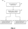
- a method 200 for sampling and processing data includes, but is not limited to including, receiving 201 input subsurface data from a field survey, and randomly selecting 203 a subset of the subsurface data.
- the method 200 further includes processing 205 the subset using a fast-track version of a processing technique, and processing 207 the subset using a full-track version of the processing technique or another technique.
- the processing technique can include, for example, but not limited to, denoising, deblending, interpolating, deconvoluting, demultiple, deghosting, imaging, and/or inversion.
- the fast-track version includes a low-cost technique that requires a relatively short amount of time compared to the full-track version, and produces a relatively low resolution result.
- the full-track version includes a high-cost technique that requires more time to complete than the fast-track version, and produces a higher resolution result than the fast-track version.
- the relatively low resolution result and the higher resolution result are used to train a machine learning model so that using the low resolution result as input to the machine learning model produces the higher resolution result, but in the relatively short amount of time comparable to using the fast-track version of the processing technique.
- a method 300 for producing high quality data within a low cost timeframe includes, but is not limited to including, receiving 301 subsurface data from the field, and performing 303 low-cost processing using a fast-track processing technique on the subsurface data to produce low-quality results.
- the method 300 includes providing 305 the low-quality results to the trained machine learning model to produce high-cost results in a low-cost timeframe, and providing 307 the high-quality results to the user.
- a system 400 for continuously training a generator 403 and a discriminator 405 to produce high-quality results in a low-cost timeframe includes, but is not limited to including, a receiver 409 processing seismic data using a low-resolution, low-cost technique, and a generator 403 applying a trained machine learning model to the processed seismic data to produce high-resolution data.
- the receiver 409 executes fast-track processing techniques that complete in a relatively fast timeframe.
- the specific processing technique is chosen based on the seismic data, and can be automatically chosen, manually chosen, or a combination of automatic and manual methods. For example, the raw dataset could be supplied to the user, and the user could select a fast-track processing technique and a full-track processing technique.
- the category of technique for example, interpolation, denoising, or recursive least squares, that is chosen for fast-track processing could be the same or different from the category that is chosen for full-track processing.
- the raw dataset could be evaluated automatically, and a processing technique appropriate for the raw dataset could be chosen automatically or suggested to a user as an option for selection.
- the generator 403 produces high-resolution data 411 and supplies those data to the discriminator 405.
- the system 400 also includes a receiver 401 processing seismic data using a high-resolution, high-cost technique, and supplying those data to the discriminator 405.
- the discriminator 405 determines 407 if the generated data and the high-cost data match. The results determined by the discriminator are fed back to the discriminator and the generator. If the generated and the high-cost data are within a threshold amount, the generator and the discriminator are rewarded, whereas the opposite is true if the generated and high-cost data differ by more than the threshold amount.
- an exemplary embodiment in accordance with the present disclosure includes system 500.
- input data 501 are simultaneously processed by low-cost, low-quality processing techniques 503 and by high-cost, high-quality processing techniques 515.
- the low-cost, low-quality processing technique 503 is frequency-domain matching pursuit Fourier interpolation (MPFI).
- MPFI frequency-domain matching pursuit Fourier interpolation
- the low-cost, low-quality processing technique 503 is 3D multistage MPFI.
- the high-cost, high-quality processing technique 515 is 3D sparse time-domain Radon interpolator (TDRI).
- TDRI time-domain Radon interpolator
- the high-cost, high-quality processing technique 515 is 3D multistage TDRI.
- the output 505 from the low-cost processing, which can be output from MPFI or 3D multistage MPFI, and the output 517 from the high-cost processing, which can be output from TDRI or 3D multistage TDRI, are provided to train 511 a machine learning model, which can be a MPFI-to-TDRI machine learning mapping.
- the low-cost, low-quality data (for example, MPFI or 3D multistage MPFI data) are provided to the trained machine learning model 513 to produce a prediction of high-cost, high-quality data 507 (for example, TDRI or 3D multistage TDRI data), that is used to produce the high-quality data 509.
- to compute 3D multistage data using the MPFI processing technique from sparsely sampled data requires 13 hours of CPU time, or three hours of elapsed time.
- To compute 3D multistage data using the TDRI processing technique requires 127,294 hours of CPU time, or 110 hours of elapsed time.
- a method for emulating multistage TDRI brings cost savings and quality improvements.
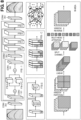
- low-cost low-resolution interpolated data 601 can be used as input to a GAN.
- High-cost high-resolution dataset 603 is used as ground truth to the GAN.
- Machine learning-derived high-resolution dataset 605 is produced when the input dataset is low-cost low-resolution interpolated data 601, and where the GAN is trained as discussed herein.
- Figure 7 illustrates a flowchart of a method for generating high-quality seismic data, according to an embodiment.
- An illustrative order of the method 700 is provided below; however, one or more portions of the method 700 may be performed in a different order, simultaneously, repeated, or omitted. At least a portion of the method 700 may be performed with a computing system 900 (described below).
- the method 700 may include receiving a first dataset, as at 705.
- the first dataset may be or include seismic data that represents a subsurface.
- the seismic data may be from a land or marine environment.
- the seismic data may be or include particle data.
- the particle data may be or include particle displacement data, particle velocity data, particle acceleration data, or a combination thereof.
- the method 700 may also include selecting a first processing technique based at least upon the first dataset, as at 710.
- the first processing technique may be or include denoising, deblending, interpolating, deconvoluting, demultiple, deghosting, imaging, inversion, residual moveout correction (RMO), noise suppression, regularization, or a combination thereof.
- the method 700 may also include producing first processed data from a sample of the first dataset using the first processing technique, as at 715.
- the first processed data may have a higher quality than the first dataset.
- the method 700 may also include selecting a second processing technique based at least upon the first dataset, as at 720.
- the second processing technique may be or include denoising, deblending, interpolating, deconvoluting, demultiple, deghosting, imaging, inversion, RMO (residual moveout correction), noise suppression, regularization, or a combination thereof.
- the second processing technique may be different than the first processing technique.
- the method 700 may also include producing second processed data from the sample using the second processing technique, as at 725.
- the second processed data may have a higher quality than the first dataset and/or the first processed data.
- the first processing technique may be or include a first interpolation technique
- the second processing technique may be or include a second interpolation technique
- the first interpolation technique is lower resolution than the second interpolation technique.
- the first interpolation technique may be or include Fourier-based interpolation
- the second interpolation technique may be or include Radon-based interpolation.
- the method 700 may also include training a machine learning model to transform the first processed data into the second processed data, as at 730.
- the machine learning model may be or include a generative adversarial network, a variational autoencoder, a diffusion model, a transformer, a neural radiance field, a convolution-based model, a non-convolution-based model, or a combination thereof.
- the training may include or generate a generator loss function, a discriminator loss function, an adversarial loss function, a modified objective function, or a combination thereof.
- This hybrid loss function encourages the generator to produce samples that align with the real data both statistically and structurally, leading to improved robustness in challenging data scenarios.
- the method 700 may also include receiving a second dataset, as at 735.
- the second dataset may be or include seismic data that represents a subsurface.
- the seismic data may be from a land or marine environment.
- the seismic data may be or include particle data.
- the particle data may be or include particle displacement data, particle velocity data, particle acceleration data, or a combination thereof.
- the method 700 may also include transforming the second dataset into a third dataset using the trained machine learning network, as at 740.
- the third dataset may have a higher quality than the first dataset, the first processed data, the second dataset, or a combination thereof.
- the method 700 may also include displaying the third dataset, as at 745.
- the method 700 may also include creating a model of the subsurface based upon the third dataset, as at 750.
- the method 700 may also include performing a wellsite action based upon the third dataset, as at 755.
- the wellsite action may be or include generating and/or transmitting a signal (e.g., using a computing system) that instructs or causes a physical action to occur at a wellsite.
- the wellsite action may also or instead include performing the physical action at the wellsite.
- the physical action may include selecting where to drill a wellbore, drilling the wellbore, varying a weight and/or torque on a drill bit that is drilling the wellbore, varying a drilling trajectory of the wellbore, varying a concentration and/or flow rate of a fluid pumped into the wellbore, or the like.
- FIG. 8 illustrates a schematic view of Swin transformer convolution residual networks, according to an embodiment.
- a Swin transformer another architecture that can be utilized in GAN is known as a Swin transformer, which can capture the global context through attention mechanisms and capture the local context through the use of convolutional neural network, offering a compelling alternative to UNet's.
- UNet excels in preserving fine-grained spatial relationships within fixed-size input images
- Swin Transformers may bring notable advantages, particularly in scenarios where understanding long-range dependencies across the entire image is paramount.
- UNet uses a pooling function, which may lose spatial resolution as it goes deeper in the network architecture, whereas the flexibility of Swin transformers in handling variable-length sequences without padding can be leveraged to accommodate diverse input sizes efficiently.
- the generator architecture in GAN which normally uses UNet, may be replaced with a Swin transformer.
- the vision transformer may help to stabilize learning using GAN architecture.
- the vision transformer may be included as part of the GAN architecture itself. In the past, people have used GAN architecture alone for seismic without realizing the benefits of including vision transformer.
- the method described herein combines the vision transformer inside the GAN while minimizing the GAN objective function and data terms in both data space and transform domain such as a Fourier transform.
- the methods of the present disclosure may be executed by a computing system.
- Figure 9 illustrates an example of such a computing system 900, in accordance with some embodiments.
- the computing system 900 may include a computer or computer system 901A, which may be an individual computer system 901A or an arrangement of distributed computer systems.
- the computer system 901A includes one or more data reception and processing modules 902 that are configured to perform various tasks according to some embodiments, such as one or more methods disclosed herein. To perform these various tasks, the data reception and processing module 902 executes independently, or in coordination with, one or more processors 904, which is (or are) connected to one or more storage media 906.
- the processor(s) 904 is (or are) also connected to a network interface 907 to allow the computer system 901A to communicate over a data network 909 with one or more additional computer systems and/or computing systems, such as 901B, 901C, and/or 901D (note that computer systems 901B, 901C and/or 901D may or may not share the same architecture as computer system 901A, and may be located in different physical locations, e.g., computer systems 901A and 901B may be located in a processing facility, while in communication with one or more computer systems such as 901C and/or 901D that are located in one or more data centers, and/or located in varying countries on different continents).
- a processor may include a microprocessor, microcontroller, processor module or subsystem, programmable integrated circuit, programmable gate array, or another control or computing device.
- the storage media 906 may be implemented as one or more computer-readable or machine-readable storage media. Note that while in the example embodiment of Figure 9 storage media 906 is depicted as within computer system 901A, in some embodiments, storage media 906 may be distributed within and/or across multiple internal and/or external enclosures of computing system 901A and/or additional computing systems.
- Storage media 906 may include one or more different forms of memory including semiconductor memory devices such as dynamic or static random access memories (DRAMs or SRAMs), erasable and programmable read-only memories (EPROMs), electrically erasable and programmable read-only memories (EEPROMs) and flash memories, magnetic disks such as fixed, floppy and removable disks, other magnetic media including tape, optical media such as compact disks (CDs) or digital video disks (DVDs), BLURAY ® disks, or other types of optical storage, or other types of storage devices.
- semiconductor memory devices such as dynamic or static random access memories (DRAMs or SRAMs), erasable and programmable read-only memories (EPROMs), electrically erasable and programmable read-only memories (EEPROMs) and flash memories
- magnetic disks such as fixed, floppy and removable disks, other magnetic media including tape
- optical media such as compact disks (CDs) or digital video disks (DVDs)
- DVDs digital video disks
- Such computer-readable or machine-readable storage medium or media is (are) considered to be part of an article (or article of manufacture).
- An article or article of manufacture may refer to any manufactured single component or multiple components.
- the storage medium or media may be located either in the machine running the machine-readable instructions, or located at a remote site from which machine-readable instructions may be downloaded over a network for execution.
- computing system 900 contains one or more seismic data module(s) 908.
- computer system 901A includes the seismic data module 908.
- a single subsurface operations module may be used to perform some aspects of one or more embodiments of the methods disclosed herein.
- a plurality of subsurface operations modules may be used to perform some aspects of methods herein.
- computing system 900 is merely one example of a computing system, and that computing system 900 may have more or fewer components than shown, may combine additional components not depicted in the example embodiment of Figure 9 , and/or computing system 900 may have a different configuration or arrangement of the components depicted in Figure 9 .
- the various components shown in Figure 9 may be implemented in hardware, software, or a combination of both hardware and software, including one or more signal processing and/or application specific integrated circuits.
- steps in the processing methods described herein may be implemented by running one or more functional modules in information processing apparatus such as general purpose processors or application specific chips, such as ASICs, FPGAs, PLDs, or other appropriate devices.
- ASICs general purpose processors or application specific chips, such as ASICs, FPGAs, PLDs, or other appropriate devices.
- Computational interpretations, models, and/or other interpretation aids may be refined in an iterative fashion; this concept is applicable to the methods discussed herein. This may include use of feedback loops executed on an algorithmic basis, such as at a computing device (e.g., computing system 900, Figure 9 ), and/or through manual control by a user who may make determinations regarding whether a given step, action, template, model, or set of curves has become sufficiently accurate for the evaluation of the subsurface three-dimensional geologic formation under consideration.
- a computing device e.g., computing system 900, Figure 9
Landscapes
- Engineering & Computer Science (AREA)
- Databases & Information Systems (AREA)
- Physics & Mathematics (AREA)
- Theoretical Computer Science (AREA)
- Remote Sensing (AREA)
- General Physics & Mathematics (AREA)
- Life Sciences & Earth Sciences (AREA)
- General Engineering & Computer Science (AREA)
- Data Mining & Analysis (AREA)
- Acoustics & Sound (AREA)
- Environmental & Geological Engineering (AREA)
- Geology (AREA)
- General Life Sciences & Earth Sciences (AREA)
- Geophysics (AREA)
- Quality & Reliability (AREA)
- Geophysics And Detection Of Objects (AREA)
Applications Claiming Priority (2)
| Application Number | Priority Date | Filing Date | Title |
|---|---|---|---|
| IN202311084714 | 2023-12-12 | ||
| US202463645339P | 2024-05-10 | 2024-05-10 |
Publications (1)
| Publication Number | Publication Date |
|---|---|
| EP4571366A1 true EP4571366A1 (de) | 2025-06-18 |
Family
ID=93923377
Family Applications (1)
| Application Number | Title | Priority Date | Filing Date |
|---|---|---|---|
| EP24219526.1A Pending EP4571366A1 (de) | 2023-12-12 | 2024-12-12 | System und verfahren zur erzeugung von seismischen daten hoher qualität aus seismischen daten niedriger qualität |
Country Status (2)
| Country | Link |
|---|---|
| US (1) | US20250190408A1 (de) |
| EP (1) | EP4571366A1 (de) |
Citations (2)
| Publication number | Priority date | Publication date | Assignee | Title |
|---|---|---|---|---|
| US20210262329A1 (en) * | 2020-02-20 | 2021-08-26 | Exxonmobil Upstream Research Company | Method for Generating Initial Models For Least Squares Migration Using Deep Neural Networks |
| US20220283329A1 (en) * | 2021-03-05 | 2022-09-08 | Aramco Overseas Company B.V. | Method and system for faster seismic imaging using machine learning |
Family Cites Families (5)
| Publication number | Priority date | Publication date | Assignee | Title |
|---|---|---|---|---|
| EP3969944A4 (de) * | 2019-05-13 | 2023-01-18 | Services Pétroliers Schlumberger | Trainieren eines maschinenlernsystems unter verwendung von harten und weichen beschränkungen |
| US11892582B2 (en) * | 2020-08-28 | 2024-02-06 | Magseis Ff Llc | Real time identification of extraneous noise in seismic surveys |
| US12474495B2 (en) * | 2021-09-23 | 2025-11-18 | Cgg Services Sas | Modeling-based machine learning for seismic processing |
| WO2024119095A1 (en) * | 2022-12-01 | 2024-06-06 | Schlumberger Technology Corporation | Wellbore log-based machine learning using a foundational model |
| US20250116176A1 (en) * | 2023-10-04 | 2025-04-10 | Schlumberger Technology Corporation | Using deep-learning models to automatically identify subsurface reservoir boundaries in real time |
-
2024
- 2024-12-12 EP EP24219526.1A patent/EP4571366A1/de active Pending
- 2024-12-12 US US18/978,757 patent/US20250190408A1/en active Pending
Patent Citations (2)
| Publication number | Priority date | Publication date | Assignee | Title |
|---|---|---|---|---|
| US20210262329A1 (en) * | 2020-02-20 | 2021-08-26 | Exxonmobil Upstream Research Company | Method for Generating Initial Models For Least Squares Migration Using Deep Neural Networks |
| US20220283329A1 (en) * | 2021-03-05 | 2022-09-08 | Aramco Overseas Company B.V. | Method and system for faster seismic imaging using machine learning |
Non-Patent Citations (1)
| Title |
|---|
| SCHONEWILLE M A ET AL: "Comparison of 3D Time-domain Radon and Matching-pursuit Fourier Interpolation", 76TH EAGE CONFERENCE & EXHIBITION 2014, 16 June 2014 (2014-06-16), pages 1 - 5, XP093270547 * |
Also Published As
| Publication number | Publication date |
|---|---|
| US20250190408A1 (en) | 2025-06-12 |
Similar Documents
| Publication | Publication Date | Title |
|---|---|---|
| EP3535607B1 (de) | Verarbeitung seismischer daten mit künstlicher intelligenz | |
| US20190169962A1 (en) | Machine Learning Training Set Generation | |
| US10380793B2 (en) | Geobody surface reconstruction | |
| EP2975438B1 (de) | Mehrskaliges verfahren für reservoirmodelle | |
| US11965998B2 (en) | Training a machine learning system using hard and soft constraints | |
| US11536862B2 (en) | Automatic feature extraction from seismic cubes | |
| US11209572B2 (en) | Meshless and mesh-based technique for modeling subterranean volumes | |
| WO2017206157A1 (en) | Systems, methods, and computer readable media for enchanced simulation of drilling dynamics | |
| WO2017206159A1 (en) | Fracture network extraction by microseismic events clustering analysis | |
| EP4571366A1 (de) | System und verfahren zur erzeugung von seismischen daten hoher qualität aus seismischen daten niedriger qualität | |
| EP4264554A1 (de) | System und verfahren zum prädiktiven geologischen zeichnen | |
| EP2863242A2 (de) | Klassifizierung und Visualisierung von Zeitabfolgedaten | |
| US20250342285A1 (en) | System and method for computing relative confidence of seismic interpretation | |
| US20250389860A1 (en) | Elastic full wave inversion with machine learning estimated elastic properties | |
| US20260072192A1 (en) | Visual difference seismic image | |
| WO2016011314A1 (en) | Core box image processing | |
| WO2025151758A1 (en) | Super resolution with deep learning for seismic image resolution enhancement | |
| US20260043314A1 (en) | Volumetric geometry quantification of near-surface carbon containers | |
| WO2025155297A1 (en) | Automatic repeatability enforcement for timelapse seismic measurements | |
| WO2025097002A1 (en) | Intelligent play fairway analysis and chance of success mapping | |
| WO2025151864A1 (en) | Rapid 3d reservoir contextualization | |
| WO2025101591A1 (en) | Physics informed machine learning for discrete nonlinear partial differential equations | |
| WO2025128808A1 (en) | Oilfield data product generation and management system | |
| WO2025199448A1 (en) | A foundation model methodology for subsurface analysis and hydrocarbon identification | |
| WO2025090454A1 (en) | Automatic noise suppression for land, obn, and das seismic data |
Legal Events
| Date | Code | Title | Description |
|---|---|---|---|
| PUAI | Public reference made under article 153(3) epc to a published international application that has entered the european phase |
Free format text: ORIGINAL CODE: 0009012 |
|
| STAA | Information on the status of an ep patent application or granted ep patent |
Free format text: STATUS: THE APPLICATION HAS BEEN PUBLISHED |
|
| AK | Designated contracting states |
Kind code of ref document: A1 Designated state(s): AL AT BE BG CH CY CZ DE DK EE ES FI FR GB GR HR HU IE IS IT LI LT LU LV MC ME MK MT NL NO PL PT RO RS SE SI SK SM TR |
|
| STAA | Information on the status of an ep patent application or granted ep patent |
Free format text: STATUS: REQUEST FOR EXAMINATION WAS MADE |
|
| 17P | Request for examination filed |
Effective date: 20251020 |