EP4576045A1 - Verfahren und elektronische vorrichtung zur unterstützung der vorbereitung eines flugs eines flugzeugs, entsprechendes computerprogramm - Google Patents
Verfahren und elektronische vorrichtung zur unterstützung der vorbereitung eines flugs eines flugzeugs, entsprechendes computerprogramm Download PDFInfo
- Publication number
- EP4576045A1 EP4576045A1 EP24221980.6A EP24221980A EP4576045A1 EP 4576045 A1 EP4576045 A1 EP 4576045A1 EP 24221980 A EP24221980 A EP 24221980A EP 4576045 A1 EP4576045 A1 EP 4576045A1
- Authority
- EP
- European Patent Office
- Prior art keywords
- aircraft
- pnt
- trajectory
- display
- quality
- Prior art date
- Legal status (The legal status is an assumption and is not a legal conclusion. Google has not performed a legal analysis and makes no representation as to the accuracy of the status listed.)
- Pending
Links
Images

Classifications
-
- G—PHYSICS
- G08—SIGNALLING
- G08G—TRAFFIC CONTROL SYSTEMS
- G08G5/00—Traffic control systems for aircraft
- G08G5/20—Arrangements for acquiring, generating, sharing or displaying traffic information
- G08G5/26—Transmission of traffic-related information between aircraft and ground stations
-
- G—PHYSICS
- G08—SIGNALLING
- G08G—TRAFFIC CONTROL SYSTEMS
- G08G5/00—Traffic control systems for aircraft
- G08G5/20—Arrangements for acquiring, generating, sharing or displaying traffic information
- G08G5/21—Arrangements for acquiring, generating, sharing or displaying traffic information located onboard the aircraft
-
- G—PHYSICS
- G08—SIGNALLING
- G08G—TRAFFIC CONTROL SYSTEMS
- G08G5/00—Traffic control systems for aircraft
- G08G5/20—Arrangements for acquiring, generating, sharing or displaying traffic information
- G08G5/22—Arrangements for acquiring, generating, sharing or displaying traffic information located on the ground
-
- G—PHYSICS
- G08—SIGNALLING
- G08G—TRAFFIC CONTROL SYSTEMS
- G08G5/00—Traffic control systems for aircraft
- G08G5/30—Flight plan management
- G08G5/32—Flight plan management for flight plan preparation
-
- G—PHYSICS
- G08—SIGNALLING
- G08G—TRAFFIC CONTROL SYSTEMS
- G08G5/00—Traffic control systems for aircraft
- G08G5/30—Flight plan management
- G08G5/34—Flight plan management for flight plan modification
-
- G—PHYSICS
- G08—SIGNALLING
- G08G—TRAFFIC CONTROL SYSTEMS
- G08G5/00—Traffic control systems for aircraft
- G08G5/50—Navigation or guidance aids
- G08G5/53—Navigation or guidance aids for cruising
-
- G—PHYSICS
- G08—SIGNALLING
- G08G—TRAFFIC CONTROL SYSTEMS
- G08G5/00—Traffic control systems for aircraft
- G08G5/50—Navigation or guidance aids
- G08G5/55—Navigation or guidance aids for a single aircraft
-
- G—PHYSICS
- G08—SIGNALLING
- G08G—TRAFFIC CONTROL SYSTEMS
- G08G5/00—Traffic control systems for aircraft
- G08G5/50—Navigation or guidance aids
- G08G5/57—Navigation or guidance aids for unmanned aircraft
Definitions
- the present invention relates to a method for assisting in the preparation of an aircraft flight, the method being implemented by an electronic preparation assistance device; as well as a computer program comprising software instructions which, when executed by a computer, implement such a preparation assistance method.
- the invention also relates to such an electronic device for assisting in preparing the aircraft for flight.
- a preparation phase for an aircraft flight in particular a preparation phase for a mission, such as a search and rescue mission, also called SAR (from the English Search And Rescue ), a mission to winch a person or an object, or a surveillance mission, is complex and represents a significant workload for a user, or more often a team, in charge of this preparation.
- a mission such as a search and rescue mission, also called SAR (from the English Search And Rescue )
- SAR from the English Search And Rescue
- a mission to winch a person or an object, or a surveillance mission is complex and represents a significant workload for a user, or more often a team, in charge of this preparation.
- the aim of the invention is then to propose a method, and an associated electronic device, for assisting in the preparation of an aircraft flight making it possible to calculate a better trajectory for the aircraft, particularly in terms of safety.
- the preparation assistance method according to the invention then makes it possible to take into account the PNT quality when calculating the trajectory, and then to have a more reliable positioning of the aircraft when it is in flight, and in doing so to improve the in-flight safety of the aircraft.
- PNT quality allows us to quantify the accuracy, reliability and integrity of positioning, navigation and time synchronization information provided by a satellite navigation system, also called a GNSS system ( Global Navigation Satellite System), such as a GPS system ( Global Positioning System ), a Galileo system, a Glonass system, or a Beidou system.
- GNSS Global Navigation Satellite System
- GPS Global Positioning System
- Galileo Galileo
- Glonass system Galileo system
- Beidou system Beidou system
- the preparation assistance method according to the invention further comprises the determination of a desired minimum threshold for the PNT quality, called the PNT threshold, and the trajectory is then calculated so that the PNT quality is greater than the PNT threshold at each point of the trajectory.
- the PNT threshold a desired minimum threshold for the PNT quality
- the trajectory is then calculated so that the PNT quality is greater than the PNT threshold at each point of the trajectory.
- the invention also relates to a computer program comprising software instructions which, when executed by a computer, implement a preparation assistance method, as defined above.
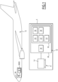
- an aeronautical platform 5 comprises an electronic device 8 for displaying information and an electronic device 10 for assisting in preparing a flight of an aircraft 12.
- the flight preparation assistance device 10 is connected to the display device 8.
- the aeronautical platform 5 is, for example, a ground platform, such as a command and planning center, a drone operations ground station, an en-route air navigation center (CRNA), a civil air traffic control center or an airline operational planning platform.
- a ground platform such as a command and planning center, a drone operations ground station, an en-route air navigation center (CRNA), a civil air traffic control center or an airline operational planning platform.
- CRNA en-route air navigation center
- civil air traffic control center or an airline operational planning platform.
- the aeronautical platform 5 is an avionics platform, typically intended to be carried on board the aircraft 12.
- the display device 8 typically comprises an information display screen 14.
- the flight preparation assistance device 10 comprises an acquisition module 20, a calculation module 22 and a display module 24. As an optional addition, the flight preparation assistance device 10 comprises a determination module 26 and/or a selection module 28.
- the flight preparation assistance device 10 comprises an information processing unit 30 formed for example of a memory 32 and a processor 34 associated with the memory 32.
- the acquisition module 20, the calculation module 22 and the display module 24, as well as, as an optional addition, the determination module 26 and the selection module 28, are each produced in the form of software, or a software brick, executable by the processor 34.
- the memory 32 of the flight preparation assistance device 10 is then capable of storing acquisition software, calculation software and display software, as well as, as an optional addition, determination software and selection software.
- the processor 34 is then capable of executing each of the software among the acquisition software, the calculation software and the display software, as well as, as an optional addition, the determination software and the selection software.
- the acquisition module 20, the calculation module 22 and the display module 24, as well as, as an optional addition, the determination module 26 and the selection module 28, are each produced in the form of a programmable logic component, such as an FPGA ( Field Programmable Gate Array), or in the form of a dedicated integrated circuit, such as an ASIC ( Application Specific Integrated Circuit).
- a programmable logic component such as an FPGA ( Field Programmable Gate Array)
- ASIC Application Specific Integrated Circuit
- the flight preparation assistance device 10 When the flight preparation assistance device 10 is produced in the form of one or more software programs, i.e. in the form of a computer program, it is also capable to be recorded on a medium, not shown, readable by a computer.
- the computer-readable medium is, for example, a medium capable of storing electronic instructions and of being coupled to a bus of a computer system.
- the readable medium is an optical disk, a magneto-optical disk, a ROM memory, a RAM memory, any type of non-volatile memory (for example EPROM, EEPROM, FLASH, NVRAM), a magnetic card or an optical card.
- a computer program comprising software instructions is then stored on the readable medium.
- the aircraft 12 is typically an airplane, such as a commercial airliner. Alternatively, the aircraft 12 is a helicopter.
- the aircraft 12 is a drone, i.e. an unmanned aerial vehicle (UAV ). According to this alternative, the aircraft 12 is then remotely piloted by an operator.
- UAV unmanned aerial vehicle
- the aircraft 12 is notably equipped with a satellite positioning system, also called a GNSS system (for Geolocation and Navigation by a Satellite System, or Global Navigation Satellite System), comprising a satellite positioning receiver 36 and an antenna 38.
- This GNSS system is optionally equipped with one or more other additional positioning assistance sensors, such as notably an inertial unit, a Doppler sensor, radio navigation in the event of loss of integrity, capacity or performance of the receiver 36.
- the GNSS system uses a constellation of satellites and makes it possible to provide a user, via the sensor(s) constituting it, with its 3D position, its 3D speed and the time.
- the GNSS system thus allows positioning, navigation and time measurement, and then forms a so-called PNT system (for Positioning, Navigation and Time).
- the GNSS system is, for example, a GPS system (from the English Global Positioning System), a Galileo system, a Glonass system, or even a Beidou system.
- the aircraft 12 includes the receiver 36, also called an on-board GNSS receiver, making it possible to receive a GNSS signal characterized by a reception quality.
- the receiver 36 also called an on-board GNSS receiver, making it possible to receive a GNSS signal characterized by a reception quality.
- the acquisition module 20 comprises at least one communication interface allowing an exchange of information with the user.
- the acquisition module 20 is configured to acquire positions of characteristic objects 40, each characteristic object 40 being chosen from the group consisting of: a passage zone, a target zone, an obstacle, and a GNSS jammer.
- the acquisition module 20 via its communication interface, allows the user to lock certain data, such as for example a position of a characteristic object 40, so that this data cannot be modified.
- a passage zone designates an area that the aircraft 12 must cross during the flight, the latter being prepared by the flight preparation assistance device 10.
- Each passage zone is for example a geographical area to be flown over, or a refueling point for the aircraft, etc.
- a target area designates an area that the aircraft 12 must reach during its flight. Each target area is typically entered before the flight by the user and represents an objective of the flight. Each target area is, for example, a geographical area to be flown over, or an airport at which the aircraft 12 must land, etc.
- An obstacle is an object present in the land or airspace close to the aircraft 12 and which must be avoided by the aircraft during its flight because it may be critical to the safety of the flight in the short, medium and long term.
- Each obstacle is, for example, a geographical area with dangerous topography, or a no-fly or no-overflight zone, etc.
- a GNSS jammer means a device capable of corrupting and/or preventing the proper reception of data by the reception chain of the GNSS system equipping the aircraft 12 in a given geographical area, each GNSS jammer having a characteristic range.
- the range of a GNSS jammer is, for example, between 50 km and 400 km.
- Each GNSS jammer is positioned in a geographical area that has strategic interest, for example a jammer near an airport, a jammer near a radio antenna, etc.
- the acquisition module 20 allows the user to indicate one or more waypoints 42. This therefore allows the user to define the waypoints 42 through which a trajectory 44 of the aircraft 12 must pass.
- the acquisition module 20 comprises a memory, not shown.
- the memory is typically capable of storing the history of data entry of a flight by the user, to allow the user to reuse them for a future flight.
- the calculation module 22 is configured to calculate the trajectory 44 of the aircraft 12 from a starting point 46 to an arrival point 48.
- the calculation module 22 is configured to calculate the trajectory 44 as a function of the positions of the characteristic objects 40 acquired by the acquisition module 20, and also as a function of an estimated ratio, called PNT quality, between a quantity representative of a quality of reception of a GNSS signal by a GNSS receiver 36 on board the aircraft 12 and a quantity representative of noise resulting from jamming.
- PNT quality an estimated ratio
- the representative quantity of the reception quality of the GNSS signal is for example an intensity of the received signal, a number of tracked satellites, a traceability and a value of the signal/noise ratio of the satellite signals, a noisier signal covering the detected one, etc.
- the representative quantity of noise resulting from voluntary and deliberate interference is, for example, a signal-to-noise level, or an attenuation, typically expressed in dB.
- the PNT quality is the result and translation of the calculation of the impacts of interference on GNSS signals in the case of jamming.
- the PNT quality is for example estimated from a calculation of the impact of interference on the GNSS signal in the case of jamming.
- An algorithm for calculating the impact of sources of electromagnetic disturbance on the operation of the GNSS system is for example described in the application FR 23 07282 filed on July 7, 2023 This document describes the calculation of the impact of interference, then the transcription of this calculated impact into different levels corresponding to GNSS service states. These levels are then used to quantify and explain PNT quality.
- the trajectory 44 calculated by the calculation module 22 consists of a set of geographic coordinates defined as a function of time, so as to define a set of coordinates taken by the aircraft 12 during the flight.
- the positions defined by these coordinates are then calculated by taking into account the positions of the characteristic objects 40, the PNT quality of the geographic areas and the waypoints 42.
- the geographic coordinates making up trajectory 44 are advantageously located in a geographic area presenting satisfactory PNT quality.
- the trajectory 44 is calculated taking into account the constraint linked to these waypoints 42.
- the display module 24 is configured to display, on the display screen 14, the calculated trajectory 44. This display is described in more detail below.
- the determination module 26 is configured to determine a desired minimum threshold for PNT quality, also called PNT threshold.
- the calculation module 22 is then configured to calculate the trajectory 44 such that the PNT quality is greater than the PNT threshold at each point of the calculated trajectory 44.
- the aircraft 12 then receives a GNSS signal with sufficient reception quality to obtain positioning of the aircraft 12 with satisfactory precision, i.e. to allow the aircraft 12 to move safely - from the point of view of its positioning - in the associated geographical area.
- the PNT threshold comprises several values, each being associated with a respective geographical area.
- the geographical areas advantageously cover all of the areas likely to be overflown by the aircraft 12 during its flight.
- the calculation module 22 is then configured to calculate the trajectory 44 such that the PNT quality is greater than the corresponding value of the PNT threshold according to the geographical area where a respective point of the calculated trajectory 44 is located.
- the value(s) of the PNT threshold can be modified by the user.
- Each value of the PNT threshold can in particular be modified after the display of the calculated trajectory 44 of the aircraft 12, the modification of at least one value of the PNT threshold then triggering the calculation 130 of a new trajectory 44 of the aircraft 12.
- the selection module 28 is configured to select at least one type of aircraft 12 from a plurality of predefined types, for example from information received from the user.
- the plurality of predefined types comprises for example: an airplane type, a helicopter type, a drone or UAV ( Unmanned Aerial Vehicle ) type; the airplane type being optionally further specified by then including a commercial airliner type, a military airplane type, a tourist airplane type, etc.
- the calculation module 22 is then configured to calculate the trajectory 44 for each selected type of aircraft 12, and each calculated trajectory 44 for a respective selected type is then displayable.
- the acquisition module 20 is then configured to advantageously implement a hierarchy of the acquisition of the input data.
- the acquisition of the data is carried out in the following order: choice of the type of aircraft, choice of the target zone, entry of the characteristic objects 40 and entry of the waypoints 42.
- the selection module 28 is optionally configured to select several types of aircraft 12, and the calculation module 22 is then configured to calculate a respective trajectory 44 for each type of aircraft 12 selected.
- the device display device 8 comprises, for example, a plurality of individual display screens 14 working together.
- a giant screen, not shown, displaying a summary of the information displayed on the individual screens 14 advantageously completes the display device 8.
- the display device 8 comprises for example, in addition to the display screen 14, an independent tablet, a head-up display device or HUD (from the English Head Up Display ), and/or a headset having mixed reality technology.
- the display module 24 is configured to display timeline 50 and a cursor 52.
- the timeline 50 comprises an initial time instant T0 corresponding to the starting point 46, and several successive subsequent time instants up to a final time instant TF corresponding to the arrival point 48, the subsequent instants being after the initial time instant T0.
- the successive subsequent time instants are typically defined in a discretized, or sampled, manner between the initial time instants T0 and final time instants TF.
- a discretization, or sampling, step i.e. a timeless gap between two successive time instants along the timeline 50, is advantageously configurable by the user. This sampling step further typically depends on the length of the timeline 50 when it is displayed on the screen 14, as well as the screen resolution. In other words, the timeline 50 is displayed in the form of a number of successive pixels, and the sampling step advantageously corresponds to at least one pixel.
- the cursor 52 is movable by the user along the timeline 50 and indicates a time instant chosen from the initial time T0 and the successive subsequent time instants and the final time instant TF.
- the trajectory 44 is then displayed by the display module 24 as a function of the chosen time instant, the position of the aircraft 12, represented by a symbol 53 in the form of an arrow, and characteristic objects 40 being notably displayed at this chosen time instant, corresponding to the position of the cursor 52 along the time line 50.
- the display module 24 is configured to display a representation of the PNT quality at different successive points of the calculated trajectory 44.
- the display module 24 is then typically configured to deliver, to the display device 8 and for their display, a map view 54 including the trajectory 44 of the aircraft 12 and one or more representations of characteristic objects 40 in their respective positions.
- the display module 24 is advantageously configured to display the map view 54 on the display device 8 according to several distinct display modes.
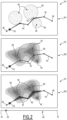
- the display module 24 is configured to display the map view 54 according to three distinct display modes, namely a nominal mode M1, a GNSS mode M2 and a PNT mode M3.
- the nominal mode M1 also called “Impacts” mode, allows a display of all the characteristic objects 40 acquired by the acquisition module 20, as well as the effects of the jamming.
- the effects of the jamming are further represented by gray circular areas 56.
- the radius of these circular areas 56 defines the range of the jamming.
- GNSS M2 mode also called “GNSS view” mode, allows the display of representative areas of effect(s) 58 of the GNSS jammer(s) on PNT quality.
- the representative areas of effect(s) 58 are centered on the GNSS jammers and depend on the calculated trajectory 44.
- the intensity of the effect(s) of the GNSS jammer(s) on PNT quality can be displayed using a color diagram (from the English heatmap chart).
- the PNT M3 mode also called “PNT fidelity” mode, allows a display similar to the display of the GNSS M2 mode, with in addition the trajectory 44 of the aircraft 12 displayed within a corridor 60 representing an approximate area of the position of the aircraft 12.
- the display module 24 is configured to display the map view 54 according to different graphic display modes: 2D mode, 3D mode or even different orientations of the map view 54, such as a view oriented in the direction of the aircraft 12. These different graphic display modes are for example at the user's choice.
- the display module 24 is configured to deliver a real representation of the geographical area adjacent to the trajectory 44, in particular in the form of contour lines.
- the display module 24 is configured to advantageously display a simplified representation of the trajectory 44 of the aircraft, in particular with only the most critical characteristic objects 40.
- the display module 24 is configured to display several windows on the display screen 14, in particular in the form of a view split into windows, each window comprising a specific display mode or a trajectory 44 for one of the selected aircraft 12.
- the preparation assistance device 10 acquires, via the acquisition module 12, the positions of characteristic objects 40, each characteristic object 40 typically being a passage zone, a target zone, an obstacle, or even a GNSS jammer.
- the acquisition of these characteristic object positions 40 can in particular be done by action of the user via the communication interface.
- the preparation assistance device 10 determines, via its determination module 26, the PNT threshold, i.e. the desired minimum threshold for the PNT quality.
- the PNT threshold i.e. the desired minimum threshold for the PNT quality.
- several PNT threshold values are determined during this determination step 110, each typically being associated with a respective geographical area.
- the value(s) of the PNT threshold can be modified by the user, in particular after displaying the calculated trajectory 44 of the aircraft 12, which then triggers the calculation of a new trajectory 44 of the aircraft 12.
- the preparation assistance device 10 moves on to a following step 120, also optional, during which it selects, via its selection module 28, at least one type of aircraft 12. This selection is also typically carried out from a user interaction.
- the preparation assistance device 10 calculates, via its calculation module 22, the trajectory 44 of the aircraft from the departure point 46 to the arrival point 48.
- the trajectory 44 of the aircraft 12 is calculated as a function of the acquired positions of the characteristic objects 40 and also as a function of the PNT quality, according to the invention.
- the trajectory 44 is advantageously calculated during the calculation step 130 as a function, in addition, of the determined PNT threshold(s), the trajectory 44 then typically being calculated in such a way that the PNT quality is greater than the PNT threshold at each point of the calculated trajectory, again in such a way that the PNT quality is greater than the corresponding value of the PNT threshold according to the associated geographical area.
- the trajectory 44 (previously calculated during the calculation state 130) is displayed via the display module 24.
- the user can then modify the display of this trajectory 44 using the multiple properties of the display module 24 described above.
- the method further comprises the possibility of adding at least one waypoint 42 with a specific PNT threshold, and the trajectory 44 is then recalculated by the calculation module 22 to include the new waypoint 42, then displayed via the display module 24.
- the user modifies the value of one or more PNT thresholds, this allows him for example to lower the PNT threshold compared to the threshold determined beforehand, in particular when the PNT quality is not a critical datum in the targeted geographical area, and this then allows greater latitude for the calculation of the trajectory 44.
- the user can then increase the PNT threshold compared to the threshold determined beforehand, which then automatically triggers the calculation of a new trajectory 44 of the aircraft 12. The latitude for the calculation of this new trajectory 44 will then be lower, but the safety of the flight of the aircraft 12 will be improved by the better PNT quality imposed, thus resulting in a more precise measurement of the location of the aircraft 12.
- the preparation assistance device 10 and the flight preparation assistance method according to the invention make it possible to calculate a better trajectory 44 for the aircraft 12, in particular in terms of safety. They also allow a reduction in the cognitive load of the user for preparing the flight of the aircraft 12.
Landscapes
- Engineering & Computer Science (AREA)
- Aviation & Aerospace Engineering (AREA)
- Physics & Mathematics (AREA)
- General Physics & Mathematics (AREA)
- Navigation (AREA)
- Traffic Control Systems (AREA)
Applications Claiming Priority (1)
| Application Number | Priority Date | Filing Date | Title |
|---|---|---|---|
| FR2314733A FR3157642A1 (fr) | 2023-12-21 | 2023-12-21 | Procédé et dispositif électronique d'aide à la préparation d'un vol d'un aéronef, programme d'ordinateur associé |
Publications (1)
| Publication Number | Publication Date |
|---|---|
| EP4576045A1 true EP4576045A1 (de) | 2025-06-25 |
Family
ID=91073230
Family Applications (1)
| Application Number | Title | Priority Date | Filing Date |
|---|---|---|---|
| EP24221980.6A Pending EP4576045A1 (de) | 2023-12-21 | 2024-12-20 | Verfahren und elektronische vorrichtung zur unterstützung der vorbereitung eines flugs eines flugzeugs, entsprechendes computerprogramm |
Country Status (2)
| Country | Link |
|---|---|
| EP (1) | EP4576045A1 (de) |
| FR (1) | FR3157642A1 (de) |
Citations (4)
| Publication number | Priority date | Publication date | Assignee | Title |
|---|---|---|---|---|
| FR2307282A1 (fr) | 1975-04-10 | 1976-11-05 | Philips Nv | Lunette optique |
| US11043132B1 (en) * | 2017-02-17 | 2021-06-22 | The Charles Stark Draper Laboratory, Inc. | Systems and methods for determining quality and integrity of source information to determine navigation information of an object |
| US20220018972A1 (en) * | 2020-07-14 | 2022-01-20 | Spirent Communications Plc | Path planning using forecasts of obscuration and multipath |
| US20230280472A1 (en) * | 2022-03-02 | 2023-09-07 | Honeywell International Inc. | Systems and methods to provide real-time context-based avoidance mechanisms for gnss jamming or spoofing regions |
-
2023
- 2023-12-21 FR FR2314733A patent/FR3157642A1/fr active Pending
-
2024
- 2024-12-20 EP EP24221980.6A patent/EP4576045A1/de active Pending
Patent Citations (4)
| Publication number | Priority date | Publication date | Assignee | Title |
|---|---|---|---|---|
| FR2307282A1 (fr) | 1975-04-10 | 1976-11-05 | Philips Nv | Lunette optique |
| US11043132B1 (en) * | 2017-02-17 | 2021-06-22 | The Charles Stark Draper Laboratory, Inc. | Systems and methods for determining quality and integrity of source information to determine navigation information of an object |
| US20220018972A1 (en) * | 2020-07-14 | 2022-01-20 | Spirent Communications Plc | Path planning using forecasts of obscuration and multipath |
| US20230280472A1 (en) * | 2022-03-02 | 2023-09-07 | Honeywell International Inc. | Systems and methods to provide real-time context-based avoidance mechanisms for gnss jamming or spoofing regions |
Also Published As
| Publication number | Publication date |
|---|---|
| FR3157642A1 (fr) | 2025-06-27 |
Similar Documents
| Publication | Publication Date | Title |
|---|---|---|
| EP3267156B1 (de) | Vorrichtung und methode zur berechnung der vorhersage einer geschätzten navigationsleistung | |
| EP2178065B1 (de) | Vorrichtung zum Berechnen eines Flugplans für ein Flugzeug | |
| EP2375299B1 (de) | Flugsteuerungssystem eines unbemannten Flugzeugs | |
| EP2573586B1 (de) | Verfahren und System zur Steuerung eines Luftfahrzeugs in der Anflugphase auf eine Landebahn | |
| EP3657213B1 (de) | Lernverfahren eines neuronennetzes an bord eines luftfahrzeugs für die landehilfe dieses luftfahrzeugs, und server für die umsetzung eines solchen verfahrens | |
| FR3021107A1 (fr) | Procede d'aide a la navigation d'un aeronef avec correlation d'informations dynamiques avec une trajectoire de vol 4d | |
| EP3244977B1 (de) | Verfahren und system zur anzeige von informationen in bezug auf ein flugzeug, vorrichtung zur erzeugung der besagten informationen und zugehöriges computerprogrammprodukt | |
| FR3038750A1 (fr) | Procede d'integration d'un nouveau service de navigation dans un systeme avionique embarque a architecture ouverte de type client-serveur, en particulier d'un service de manoeuvre fim | |
| FR3053780A1 (fr) | Dispositif et methode de calcul de prediction de performance de navigation requise | |
| EP3226062B1 (de) | Verfahren zur synthetischen darstellung von wichtigen elementen in einem visualisierungssystem eines luftfahrzeugs | |
| FR3029652A1 (fr) | Procede de calcul de trajectoire d'avion soumise a des contraintes laterales et verticales | |
| WO2000039775A2 (fr) | Systeme d'aide a l'evitement de collisions d'aeronefs avec le terrain | |
| FR3002066A1 (fr) | Systeme etendu et integre de securite et de surveillance aeronautique | |
| WO2022219007A1 (fr) | Adaptation automatique du profil vertical d'un aeronef en fonction d'une incertitude de position | |
| FR3022045A1 (fr) | Procede et dispositif de determination du sens de virage optimal d'un aeronef | |
| EP3964796B1 (de) | Verfahren und system zur unterstüzung bei der navigation eines flugzeugs und entsprechendes flugzeug | |
| FR2853439A1 (fr) | Procede et dispositf embarque d'aide au pilotage en l'absence de controle aerien | |
| EP4740043A1 (de) | Verfahren zur berechnung und/oder zur überwachung des betriebs eines satellitenpositionierungssystems an bord eines fahrzeugs sowie zugehörige vorrichtung und computerprogrammprodukt | |
| FR3157642A1 (fr) | Procédé et dispositif électronique d'aide à la préparation d'un vol d'un aéronef, programme d'ordinateur associé | |
| WO2025012131A1 (fr) | Procédé de calcul et/ou de surveillance du fonctionnement d'un système de positionnement par satellites embarqué dans un véhicule, et dispositif et produit programme d'ordinateur associés | |
| FR3120266A1 (fr) | Système électronique d’aide au pilotage d’un drone, procédé et programme d’ordinateur associés | |
| FR3003356A1 (fr) | Procede d'observation d'une zone au moyen d'un drone | |
| FR3109630A1 (fr) | Dispositif électronique et procédé d'aide à la configuration d'un vol d'un aéronef, programme d'ordinateur associé | |
| FR3073316B1 (fr) | Procede et dispositif electronique de filtrage d'informations de trafic dans un domaine aeroportuaire, programme d'ordinateur associe | |
| WO2022152723A1 (fr) | Dispositif électronique de stockage d'une base de données terrain, procédé de génération d'une telle base de données, système avionique, procédé de surveillance et programmes d'ordinateur associés |
Legal Events
| Date | Code | Title | Description |
|---|---|---|---|
| PUAI | Public reference made under article 153(3) epc to a published international application that has entered the european phase |
Free format text: ORIGINAL CODE: 0009012 |
|
| STAA | Information on the status of an ep patent application or granted ep patent |
Free format text: STATUS: THE APPLICATION HAS BEEN PUBLISHED |
|
| AK | Designated contracting states |
Kind code of ref document: A1 Designated state(s): AL AT BE BG CH CY CZ DE DK EE ES FI FR GB GR HR HU IE IS IT LI LT LU LV MC ME MK MT NL NO PL PT RO RS SE SI SK SM TR |
|
| STAA | Information on the status of an ep patent application or granted ep patent |
Free format text: STATUS: REQUEST FOR EXAMINATION WAS MADE |
|
| 17P | Request for examination filed |
Effective date: 20251127 |