EP4583034A1 - Verwaltungsunterstützungssystem für gebäude oder tiefbaustruktur - Google Patents
Verwaltungsunterstützungssystem für gebäude oder tiefbaustruktur Download PDFInfo
- Publication number
- EP4583034A1 EP4583034A1 EP23859737.1A EP23859737A EP4583034A1 EP 4583034 A1 EP4583034 A1 EP 4583034A1 EP 23859737 A EP23859737 A EP 23859737A EP 4583034 A1 EP4583034 A1 EP 4583034A1
- Authority
- EP
- European Patent Office
- Prior art keywords
- building
- civil engineering
- target
- computer apparatus
- engineering structure
- Prior art date
- Legal status (The legal status is an assumption and is not a legal conclusion. Google has not performed a legal analysis and makes no representation as to the accuracy of the status listed.)
- Pending
Links
Images





Classifications
-
- G—PHYSICS
- G06—COMPUTING OR CALCULATING; COUNTING
- G06Q—INFORMATION AND COMMUNICATION TECHNOLOGY [ICT] SPECIALLY ADAPTED FOR ADMINISTRATIVE, COMMERCIAL, FINANCIAL, MANAGERIAL OR SUPERVISORY PURPOSES; SYSTEMS OR METHODS SPECIALLY ADAPTED FOR ADMINISTRATIVE, COMMERCIAL, FINANCIAL, MANAGERIAL OR SUPERVISORY PURPOSES, NOT OTHERWISE PROVIDED FOR
- G06Q50/00—Information and communication technology [ICT] specially adapted for implementation of business processes of specific business sectors, e.g. utilities or tourism
- G06Q50/08—Construction
-
- G—PHYSICS
- G05—CONTROLLING; REGULATING
- G05D—SYSTEMS FOR CONTROLLING OR REGULATING NON-ELECTRIC VARIABLES
- G05D1/00—Control of position, course, altitude or attitude of land, water, air or space vehicles, e.g. using automatic pilots
- G05D1/60—Intended control result
- G05D1/656—Interaction with payloads or external entities
- G05D1/689—Pointing payloads towards fixed or moving targets
-
- G—PHYSICS
- G05—CONTROLLING; REGULATING
- G05D—SYSTEMS FOR CONTROLLING OR REGULATING NON-ELECTRIC VARIABLES
- G05D1/00—Control of position, course, altitude or attitude of land, water, air or space vehicles, e.g. using automatic pilots
- G05D1/20—Control system inputs
- G05D1/24—Arrangements for determining position or orientation
- G05D1/244—Arrangements for determining position or orientation using passive navigation aids external to the vehicle, e.g. markers, reflectors or magnetic means
- G05D1/2446—Arrangements for determining position or orientation using passive navigation aids external to the vehicle, e.g. markers, reflectors or magnetic means the passive navigation aids having encoded information, e.g. QR codes or ground control points
-
- E—FIXED CONSTRUCTIONS
- E04—BUILDING
- E04G—SCAFFOLDING; FORMS; SHUTTERING; BUILDING IMPLEMENTS OR AIDS, OR THEIR USE; HANDLING BUILDING MATERIALS ON THE SITE; REPAIRING, BREAKING-UP OR OTHER WORK ON EXISTING BUILDINGS
- E04G21/00—Preparing, conveying, or working-up building materials or building elements in situ; Other devices or measures for constructional work
- E04G21/14—Conveying or assembling building elements
- E04G21/16—Tools or apparatus
- E04G21/18—Adjusting tools; Templates
-
- E—FIXED CONSTRUCTIONS
- E04—BUILDING
- E04G—SCAFFOLDING; FORMS; SHUTTERING; BUILDING IMPLEMENTS OR AIDS, OR THEIR USE; HANDLING BUILDING MATERIALS ON THE SITE; REPAIRING, BREAKING-UP OR OTHER WORK ON EXISTING BUILDINGS
- E04G23/00—Working measures on existing buildings
-
- G—PHYSICS
- G05—CONTROLLING; REGULATING
- G05D—SYSTEMS FOR CONTROLLING OR REGULATING NON-ELECTRIC VARIABLES
- G05D2105/00—Specific applications of the controlled vehicles
- G05D2105/80—Specific applications of the controlled vehicles for information gathering, e.g. for academic research
- G05D2105/85—Specific applications of the controlled vehicles for information gathering, e.g. for academic research for patrolling or reconnaissance for police, security or military applications
-
- G—PHYSICS
- G05—CONTROLLING; REGULATING
- G05D—SYSTEMS FOR CONTROLLING OR REGULATING NON-ELECTRIC VARIABLES
- G05D2105/00—Specific applications of the controlled vehicles
- G05D2105/80—Specific applications of the controlled vehicles for information gathering, e.g. for academic research
- G05D2105/87—Specific applications of the controlled vehicles for information gathering, e.g. for academic research for exploration, e.g. mapping of an area
-
- G—PHYSICS
- G05—CONTROLLING; REGULATING
- G05D—SYSTEMS FOR CONTROLLING OR REGULATING NON-ELECTRIC VARIABLES
- G05D2105/00—Specific applications of the controlled vehicles
- G05D2105/80—Specific applications of the controlled vehicles for information gathering, e.g. for academic research
- G05D2105/89—Specific applications of the controlled vehicles for information gathering, e.g. for academic research for inspecting structures, e.g. wind mills, bridges, buildings or vehicles
-
- G—PHYSICS
- G05—CONTROLLING; REGULATING
- G05D—SYSTEMS FOR CONTROLLING OR REGULATING NON-ELECTRIC VARIABLES
- G05D2107/00—Specific environments of the controlled vehicles
- G05D2107/90—Building sites; Civil engineering
-
- G—PHYSICS
- G05—CONTROLLING; REGULATING
- G05D—SYSTEMS FOR CONTROLLING OR REGULATING NON-ELECTRIC VARIABLES
- G05D2109/00—Types of controlled vehicles
- G05D2109/10—Land vehicles
-
- G—PHYSICS
- G05—CONTROLLING; REGULATING
- G05D—SYSTEMS FOR CONTROLLING OR REGULATING NON-ELECTRIC VARIABLES
- G05D2111/00—Details of signals used for control of position, course, altitude or attitude of land, water, air or space vehicles
- G05D2111/10—Optical signals
- G05D2111/17—Coherent light, e.g. laser signals
Definitions
- This invention relates to a management assistance system for a building or a civil engineering structure.
- BIM is an abbreviation for Building Information Modeling, by which a three-dimensional model of a building created on a computer will have various attributes added thereto.
- CIM is an abbreviation for Construction Information Modeling, which is an idea of BIM applied to the field of civil engineering.
- BIM/CIM Introduction of BIM/CIM, from the planning, survey and design phases will make it easier to share information in the subsequent phases including construction, maintenance and management, and will streamline and upgrade a series of operations and businesses.
- BIM/CIM is also expected to yield secondary effect of improving the life of the people through better implementation, maintenance and management of infrastructure, and of enhancing motivation of workers engaged in the fields of construction and civil engineering.
- Patent Literature 1 a series of various construction management systems on the premise of introduction of BIM/CIM have been proposed (see Patent Literature 1, for example).
- a system according to Patent Literature 1 is structured to photograph the individual members that constitute BIM with a camera, and to link the photographed parts and the acquired image.
- the system can improve traceability of an object to be constructed on the member basis, and can improve convenience of construction management.
- the photographing work mainly relies upon the worker (human), thus leaving room for improvement in terms of saving of man-hour and improvement of safety of the worker.
- This invention was arrived at in consideration of the aforementioned problem, and is to provide a management assistance system capable of saving man-hour and improving safety in construction or civil engineering works by the worker.
- a management assistance system for a building or a civil engineering structure including: a database that stores attribute information for building information modeling (BIM) enabling three-dimensional expression of a building, or construction information modeling (CIM) enabling three-dimensional expression of a civil engineering structure, by combining objects that correspond to a plurality of structures that constitute the building or the civil engineering structure; a plurality of target markers attached to specific structures which are parts of the plurality of structures, each having depicted thereon an identification pattern identifiable from each other; a mobile robot having a scanner mounted thereon, and being structured to patrol a yard of the building or the civil engineering structure, and to scan the periphery with the scanner, thereby acquiring three-dimensional point cloud data; and a computer apparatus structured to analyze the point cloud data acquired during patrol by the mobile robot to detect the target markers, and to recognize position and posture of the specific structures having the detected target markers attached thereon, the computer apparatus being able to acquire identification information of the target markers, from the identification pattern of the detected target markers,
- BIM building information modeling
- the mobile robot scans a specific structure to be managed to acquire the point cloud data
- the computer apparatus analyzes the point cloud data to identify position and posture of the thus identified specific structure, which are reflected on attribute information for BIM or CIM in a database.
- the user is therefore no longer necessary to come close to the specific structure to be managed, thus successfully reducing the man-hour.
- the worker is thus kept safe, even if the specific structure resides in a high risk location such as high place.
- This invention can provide a management assistance system capable of saving man-hour and improving safety of the worker in construction or civil engineering works.
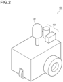
- the management assistance system 100 has a communication terminal 110, a management apparatus 120, and a mobile robot 130.
- the management apparatus 120 contains a computer apparatus 121 and a database 122.
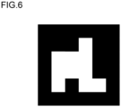
- the region 14 is arranged in an outermost part of the target marker 10, and surrounds the region 11, the region 12 and the region 13.
- the computer apparatus 121 is not always necessary to determine all places, unmeasurable by the laser scanner 132, as the range that corresponds to the region 13, and is instead preferred to narrow down the range that corresponds to the region 13, with reference to other condition.
- the computer apparatus 121 may analyze the shape of the unmeasurable range presented by the error map, and may determine the range as a position where the target marker 10 (region 13) resides, provided that the analyzed shape matches a predetermined shape (having a square contour, in this embodiment).
- the computer apparatus 121 may analyze the size of the unmeasurable range presented by the error map, and may determine the range as a position where the target marker 10 (region 13) resides, if the analyzed size fall within a predetermined threshold (smaller than the uppermost threshold, and larger than lowermost threshold).
- the computer apparatus 121 can detect the center position of the target marker 10 by a computer process, by analyzing the shape, pattern or color of the region 11.
- the computer apparatus 121 can determine the identification pattern assigned to the target marker 10, by analyzing the shape, pattern or color of the region 12.
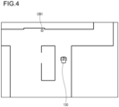
- the communication terminal 110 can read the attribute information stored in the database 122 to display a list (not illustrated) of the registered objects to be managed, and can transmit, upon selection of the object OB1 through user's operation, an action plan created according to the prior map and the position information of the object OB1, and the identification pattern of the target marker 10 corresponded to the object OB1, to the mobile robot 130.
- the mobile robot 130 autonomously travels in the yard, with reference to the thus received position information of the object OB1.
- the mobile robot 130 of this embodiment being functionalized to autonomously avoid collision on the wall, can autonomously travel along a route directed to the designated object OB1 without colliding on the wall, even if a route possibly causing collision on the wall were transmitted as the action plan to the mobile robot 130.
- the yard of the building or civil engineering structure, through which the mobile robot 130 autonomously travels, may contain object or human having not been arranged in the prior map.
- a uniqueness of the management assistance system 100 is that a rough route is created in the planning phase (a phase of user's operation made on the communication terminal 110), so as to allow the mobile robot 130 to autonomously make decision and travel.
- the collision avoidance function of the mobile robot 130 is implemented by real-time decision of a travel route during autonomous travel, by collating the aforementioned prior map (that represents the yard of the building or civil engineering structure preliminarily prepared according to BIM or CIM), with a nearby object detected by the mounted sensor 131.
- the mobile robot 130 upon detection of any object absent in the prior map, can autonomously travel along a travel route that can avoid collision on the object.
- the mobile robot 130 Upon arrival at the target position (near the object OB1) designated by the user's operation, while avoiding collision on the nearby object or human, the mobile robot 130 causes scanning with use of the laser scanner 132, to acquire the point cloud data that represents the shape and posture of the object OB1 that resides near the target position.
- the point cloud data acquired by the mobile robot 130 is transmitted to the computer apparatus 121.
- the computer apparatus 121 can analyze the point cloud data acquired during patrol by the mobile robot 130 to detect the target marker 10, and can recognize position and posture of the object OB1 having the detected target marker 10 attached thereon.
- the computer apparatus 121 can also acquire the identification information of the target marker 10, from the identification pattern of the detected target marker 10, and, if the object corresponded to the acquired identification information is corresponded to an existing object (object OB1) stored in the database 122, can collate the position and posture information of the structure, with the position and posture of the object OB1 actually measured.
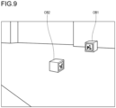
- FIGs. 7 to 9 are schematic drawings illustrating the point cloud data acquired by the mobile robot 130.
- FIG. 7 illustrates a case where the position and posture of the object OB1 represented by the point cloud data coincide with the position and posture of the object OB1 stored in the database 122.
- the position and posture information of the object OB1 stored in the database 122 is in conformity with reality.
- the computer apparatus 121 will therefore not update the position and posture information of the object OB1 stored in the database 122.
- FIG. 8 illustrates a case where the position and posture of the object OB1 represented by the point cloud data do not coincide with the position and posture of the object OB1 stored in the database 122.
- a virtual object PP1 depicted with a two-dot chain line in FIG. 8 represents the position and posture information of the object OB1 stored in the database 122.
- the position and posture information of the object OB1 stored in the database 122 is not in conformity with reality.
- the computer apparatus 121 will therefore update the position and posture information of the object OB1 stored in the database 122, with reference to the position and posture of the object OB1 recognized according to the point cloud data.
- FIG. 9 illustrates a case where the point cloud data contains position and posture of an object OB2 having another target marker attached thereon, besides the object OB1 having the target marker 10 attached thereon.
- the object OB2 herein is defined as a structure corresponded to none of the objects stored in the database 122 (an object corresponded to a new target marker).
Landscapes
- Engineering & Computer Science (AREA)
- Physics & Mathematics (AREA)
- General Physics & Mathematics (AREA)
- Aviation & Aerospace Engineering (AREA)
- Radar, Positioning & Navigation (AREA)
- Remote Sensing (AREA)
- Automation & Control Theory (AREA)
- Business, Economics & Management (AREA)
- General Health & Medical Sciences (AREA)
- Tourism & Hospitality (AREA)
- Health & Medical Sciences (AREA)
- Human Resources & Organizations (AREA)
- Marketing (AREA)
- Primary Health Care (AREA)
- Strategic Management (AREA)
- Economics (AREA)
- General Business, Economics & Management (AREA)
- Theoretical Computer Science (AREA)
- Control Of Position, Course, Altitude, Or Attitude Of Moving Bodies (AREA)
- Management, Administration, Business Operations System, And Electronic Commerce (AREA)
- Processing Or Creating Images (AREA)
- Working Measures On Existing Buildindgs (AREA)
- Alarm Systems (AREA)
Applications Claiming Priority (2)
| Application Number | Priority Date | Filing Date | Title |
|---|---|---|---|
| JP2022137780A JP7369375B1 (ja) | 2022-08-31 | 2022-08-31 | 建築物又は土木構造物の管理支援システム |
| PCT/JP2023/018951 WO2024047967A1 (ja) | 2022-08-31 | 2023-05-22 | 建築物又は土木構造物の管理支援システム |
Publications (2)
| Publication Number | Publication Date |
|---|---|
| EP4583034A1 true EP4583034A1 (de) | 2025-07-09 |
| EP4583034A4 EP4583034A4 (de) | 2025-11-26 |
Family
ID=88418616
Family Applications (1)
| Application Number | Title | Priority Date | Filing Date |
|---|---|---|---|
| EP23859737.1A Pending EP4583034A4 (de) | 2022-08-31 | 2023-05-22 | Verwaltungsunterstützungssystem für gebäude oder tiefbaustruktur |
Country Status (5)
| Country | Link |
|---|---|
| US (1) | US20250334978A1 (de) |
| EP (1) | EP4583034A4 (de) |
| JP (1) | JP7369375B1 (de) |
| TW (1) | TWI847855B (de) |
| WO (1) | WO2024047967A1 (de) |
Family Cites Families (14)
| Publication number | Priority date | Publication date | Assignee | Title |
|---|---|---|---|---|
| JP5138068B2 (ja) * | 2011-04-19 | 2013-02-06 | 新菱冷熱工業株式会社 | 施工管理システムおよび施工管理方法 |
| US9222771B2 (en) * | 2011-10-17 | 2015-12-29 | Kla-Tencor Corp. | Acquisition of information for a construction site |
| EP3223200A1 (de) * | 2016-03-22 | 2017-09-27 | Hexagon Technology Center GmbH | Baustellenverwaltung |
| JP2017187904A (ja) * | 2016-04-05 | 2017-10-12 | 清水建設株式会社 | 建築部材管理システム及び建築部材管理方法 |
| JP7113611B2 (ja) * | 2017-11-30 | 2022-08-05 | 大成建設株式会社 | 位置特定装置、位置特定プログラム及び位置特定方法、並びに、撮影画像登録装置、撮影画像登録プログラム及び撮影画像登録方法 |
| US11348322B1 (en) * | 2018-11-09 | 2022-05-31 | Doxel, Inc. | Tracking an ongoing construction by using fiducial markers |
| DE102019202304B4 (de) * | 2019-02-20 | 2021-01-28 | Siemens Schweiz Ag | Verfahren und Anordnung zum Erstellen eines digitalen Gebäudemodells |
| JP7240573B2 (ja) | 2019-03-15 | 2023-03-16 | ダイダン株式会社 | 施工支援システムおよび施工支援装置 |
| JP2021131652A (ja) * | 2020-02-19 | 2021-09-09 | 株式会社トプコン | データ構造、記録媒体、プログラム、及びシステム |
| CN111599007B (zh) * | 2020-05-26 | 2021-05-25 | 王梅莹 | 一种基于无人机航拍的智慧城市cim道路贴图方法 |
| CN112906956A (zh) * | 2021-02-05 | 2021-06-04 | 希盟泰克(重庆)实业发展有限公司 | 一种联合bim与cim的城市能耗预测方法 |
| JP2022137780A (ja) | 2021-03-09 | 2022-09-22 | 公益財団法人鉄道総合技術研究所 | ロックボルトの長さの決定方法 |
| CN114417458B (zh) * | 2021-12-22 | 2024-12-31 | 山东同圆数字科技有限公司 | 一种基于cim技术的建设项目在线多维报建协同系统 |
| CN114708699B (zh) * | 2022-06-01 | 2022-08-12 | 天津理工大学 | 基于cim的建筑运维监控报警系统及方法 |
-
2022
- 2022-08-31 JP JP2022137780A patent/JP7369375B1/ja active Active
-
2023
- 2023-05-22 US US18/867,346 patent/US20250334978A1/en active Pending
- 2023-05-22 EP EP23859737.1A patent/EP4583034A4/de active Pending
- 2023-05-22 WO PCT/JP2023/018951 patent/WO2024047967A1/ja not_active Ceased
- 2023-08-31 TW TW112133020A patent/TWI847855B/zh active
Also Published As
| Publication number | Publication date |
|---|---|
| TWI847855B (zh) | 2024-07-01 |
| US20250334978A1 (en) | 2025-10-30 |
| JP2024033883A (ja) | 2024-03-13 |
| JP7369375B1 (ja) | 2023-10-26 |
| TW202418209A (zh) | 2024-05-01 |
| EP4583034A4 (de) | 2025-11-26 |
| WO2024047967A1 (ja) | 2024-03-07 |
Similar Documents
| Publication | Publication Date | Title |
|---|---|---|
| US11568559B2 (en) | Localization of a surveying instrument | |
| US12145823B2 (en) | Systems and methods for assisting a crane operator | |
| EP4141474A1 (de) | System zur 3d-vermessung durch ein autonomes roboterfahrzeugs unter verwendung von lidar-slam und einer geschätzten punkteverteilungskarte für die bahnplanung | |
| JP7113611B2 (ja) | 位置特定装置、位置特定プログラム及び位置特定方法、並びに、撮影画像登録装置、撮影画像登録プログラム及び撮影画像登録方法 | |
| CN110293965B (zh) | 泊车方法和控制装置、车载设备及计算机可读介质 | |
| CA2918552A1 (en) | Survey data processing device, survey data processing method, and program therefor | |
| KR20180087784A (ko) | 이동 객체를 식별하여 맵을 작성하는 방법 및 이를 구현하는 로봇 | |
| CN112292580A (zh) | 定位系统和用于运行该定位系统的方法 | |
| US12462424B2 (en) | Localization of a surveying instrument | |
| US20240289901A1 (en) | Managing a construction project with the help of aerial-captured images | |
| Braun et al. | Bim-based progress monitoring | |
| Du et al. | Optimized motion planning for mobile robots in dynamic construction environments with low-feature mapping and pose-based positioning | |
| JP7503927B2 (ja) | 建設作業管理システムおよび自動巡回移動体 | |
| KR102252295B1 (ko) | 실내 토폴로지맵 생성 방법 및 이를 위한 자율주행 로봇 | |
| EP4583034A1 (de) | Verwaltungsunterstützungssystem für gebäude oder tiefbaustruktur | |
| KR102603877B1 (ko) | 차량의 정밀 측위 방법 및 장치 | |
| CN113759911A (zh) | 一种建图的方法、装置、电子设备及存储介质 | |
| US20230184550A1 (en) | Mobile reality capture device using motion state detection for providing feedback on generation of 3d measurement data | |
| JP7489802B2 (ja) | 建設作業支援システムおよび建設作業支援方法 | |
| JP7588407B2 (ja) | 建築物又は土木構造物の管理支援方法、並びに、建築物又は土木構造物の管理支援システム | |
| KR20240009032A (ko) | 모바일장치를 활용한 건설객체 점군 데이터 자동수집시스템 및 자동수집방법 | |
| JP2022116693A (ja) | 制限表面干渉チェックシステム | |
| KR102847261B1 (ko) | 구조물 및 객체 정보 획득을 위한 다중센서 기반 포터블 장치 | |
| US20240161329A1 (en) | Localization systems and methods |
Legal Events
| Date | Code | Title | Description |
|---|---|---|---|
| STAA | Information on the status of an ep patent application or granted ep patent |
Free format text: STATUS: THE INTERNATIONAL PUBLICATION HAS BEEN MADE |
|
| PUAI | Public reference made under article 153(3) epc to a published international application that has entered the european phase |
Free format text: ORIGINAL CODE: 0009012 |
|
| STAA | Information on the status of an ep patent application or granted ep patent |
Free format text: STATUS: REQUEST FOR EXAMINATION WAS MADE |
|
| 17P | Request for examination filed |
Effective date: 20241203 |
|
| AK | Designated contracting states |
Kind code of ref document: A1 Designated state(s): AL AT BE BG CH CY CZ DE DK EE ES FI FR GB GR HR HU IE IS IT LI LT LU LV MC ME MK MT NL NO PL PT RO RS SE SI SK SM TR |
|
| A4 | Supplementary search report drawn up and despatched |
Effective date: 20251028 |
|
| RIC1 | Information provided on ipc code assigned before grant |
Ipc: G06Q 50/08 20120101AFI20251022BHEP Ipc: E04G 21/00 20060101ALI20251022BHEP Ipc: G05D 1/20 20240101ALI20251022BHEP Ipc: G05D 1/43 20240101ALI20251022BHEP |
|
| DAV | Request for validation of the european patent (deleted) | ||
| DAX | Request for extension of the european patent (deleted) |