JP2007149046A - 地理画像処理システム - Google Patents
地理画像処理システム Download PDFInfo
- Publication number
- JP2007149046A JP2007149046A JP2006038004A JP2006038004A JP2007149046A JP 2007149046 A JP2007149046 A JP 2007149046A JP 2006038004 A JP2006038004 A JP 2006038004A JP 2006038004 A JP2006038004 A JP 2006038004A JP 2007149046 A JP2007149046 A JP 2007149046A
- Authority
- JP
- Japan
- Prior art keywords
- feature
- geographic image
- contour
- house frame
- feature point
- Prior art date
- Legal status (The legal status is an assumption and is not a legal conclusion. Google has not performed a legal analysis and makes no representation as to the accuracy of the status listed.)
- Granted
Links
- 238000012545 processing Methods 0.000 title abstract description 78
- 239000000284 extract Substances 0.000 claims abstract description 9
- 238000000605 extraction Methods 0.000 claims description 49
- 238000000034 method Methods 0.000 description 40
- 230000008569 process Effects 0.000 description 25
- 238000010586 diagram Methods 0.000 description 11
- 239000000470 constituent Substances 0.000 description 3
- 230000008859 change Effects 0.000 description 2
- 238000012217 deletion Methods 0.000 description 2
- 230000037430 deletion Effects 0.000 description 2
- 238000001514 detection method Methods 0.000 description 2
- 230000006872 improvement Effects 0.000 description 2
- 230000004913 activation Effects 0.000 description 1
- 230000004397 blinking Effects 0.000 description 1
- 238000012937 correction Methods 0.000 description 1
- 230000006870 function Effects 0.000 description 1
- 238000003384 imaging method Methods 0.000 description 1
- 238000012423 maintenance Methods 0.000 description 1
- 238000011160 research Methods 0.000 description 1
Images







Landscapes
- Processing Or Creating Images (AREA)
- Image Processing (AREA)
- Image Analysis (AREA)
- Instructional Devices (AREA)
Abstract
【解決手段】地理画像中の建築物等の輪郭、すなわちエッジを抽出し、抽出したエッジに基づいて、地理画像中の建築物等の構造上の特徴点を抽出し、ユーザがこの特徴点に基づいて建築物等の輪郭を画定することができる地理画像処理システム。
【選択図】図1
Description
図1は、本発明の地理画像処理システムの構成を概略的に示すブロック図である。図1において、本システムは、パソコン、ワークステーション等から構成される処理装置10と、メインメモリとして使用されるRAM(ランダムアクセスメモリ)及び磁気ディスク記憶装置等の補助記憶装置とを含む記憶装置20と、入出力装置30とを備えている。
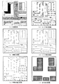
図2は、本システムにより行われる画像処理の概要を例示する図である。図2(a)は、予め記憶装置20に記憶されている地理画像データ21である。この地理画像データに対して、エッジ抽出処理を行うことにより、図2(b)に示すエッジ抽出画像が得られる。このエッジ抽出画像に対して、細線化処理を行って図2(c)に示す細線化画像を取得し、さらに、ノイズ除去を行って図2(d)に示す画像を得る。この画像は、建築物等の輪郭のみが抽出された画像であり、記憶装置20においてエッジデータ22として記憶される。以上のエッジ抽出処理は、Sobelフィルタ(非特許文献1参照)などのエッジフィルタを使用して行うことができる。この画像から建築物等の家枠を構成する可能性のある点である特徴点を抽出して、図2(e)に示す特徴点抽出画像を得る。この画像中の特徴点の座標データが記憶装置20において特徴点データ23として記憶される。最後に、地理画像データ21と特徴点データ23とを合わせて表示し、ユーザ操作により家枠を画定する入力を受け付けて、図2(f)に示す家枠表示画像が得られる。
以下、本発明の地理画像処理システムにおけるエッジ抽出処理、特徴点抽出処理、家枠画定処理について、詳細を説明する。本システムにおいて、地理画像処理プログラム40が起動されると、エッジ抽出部100、特徴点抽出部200、家枠画定処理部300の順に処理が実行される。以下、それぞれによる処理の詳細を述べる。
図3は、地理画像処理プログラム40のエッジ抽出部100による処理の流れを示すフローチャートである。図3において、エッジ抽出部100は、記憶装置20から地理画像データ21を読み込み(S301)、画像中の建築物等のエッジを抽出する(S302)。エッジを抽出する手法としては、種々の周知技術が適用可能である。建築物の輪郭を抽出できればどの手法を用いてもよい。本システムでは、上記したSobelフィルタを使用するものとする。この処理によって生成される図2(b)に示すような画像をエッジ抽出画像と呼ぶ。
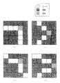
図4は、地理画像処理プログラム40の特徴点抽出部200による処理の流れを示すフローチャートである。図4において、特徴点抽出部200は、記憶装置20からエッジデータ22を読み込み(S401)、このデータに含まれる特徴点として、各エッジの端点を抽出し(S402)、各エッジの交点を抽出し(S403)、各エッジの角点を抽出する(S404)。抽出された端点、交点、角点のそれぞれの座標を、特徴点データ23として記憶装置20に記録する(S405)。
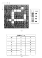
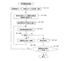
図8は、地理画像処理プログラム40の家枠画定処理部300による処理の流れを示すフローチャートである。また、図9は、家枠画定処理部300による処理を行う際にユーザに提示されるインタフェース画面を示す図である。図8において、家枠画定処理部300は、記憶装置20から地理画像データ21と、特徴点データ23とを読み込み、地理画像を表示装置32等に表示する(S801)。この表示画面において、ユーザは、入力装置31等を用いて地理画像中の家枠を画定する操作を行うことができるほか、画面を拡大したり表示箇所を変更したりすることができるようになっている。その後、家枠画定処理部300は、変数Nを1に初期化する(S802)。変数Nは、地理画像中の1つの閉じた領域(建築物等が占める領域に相当する)を構成する家枠群に含まれる家枠構成点の識別番号として用いられる。
図11は、地理画像処理プログラム40の家枠画定処理部300による処理の他の形態について、流れを示すフローチャートである。また、図12は、家枠画定処理部300による処理を行う際にユーザに提示されるインタフェース画面を示す図である。図11において、家枠画定処理部300は、記憶装置20から地理画像データ21と、家枠データ24とを読み込み、地理画像を表示装置32等に表示する(S1101)。この表示画面において、ユーザは、入力装置31等を用いて地理画像中の家枠を画定する操作を行うことができるほか、画面を拡大したり表示箇所を変更したりすることができるようになっている。
20 記憶装置
21 地理画像データ
22 エッジデータ
23 特徴点データ
24 家枠データ
30 入出力装置
31 入力装置
32 表示装置
33 プリンタ
40 地理画像処理プログラム
100 エッジ抽出部
200 特徴点抽出部
300 家枠画定処理部
Claims (9)
- 地理画像に含まれる地物の輪郭を画定するためのシステムであって、
地理画像データからエッジを抽出するエッジ抽出手段と、
前記抽出されたエッジから特徴点を抽出する特徴点抽出手段と、
前記地理画像と前記特徴点とを表示し、ユーザによる地物の輪郭を画定する入力を受け付ける輪郭画定手段とを備えていることを特徴とするシステム。 - 前記エッジ抽出手段は、地理画像データからエッジを抽出して得られるデータを2値化し、全てのエッジを1画素幅とする細線化を行い、所定長さに満たないエッジをノイズとして除去することを特徴とする請求項1に記載のシステム。
- 前記特徴点抽出手段は、前記抽出されたエッジの端点、交点、角点のうち少なくとも1種類を特徴点として抽出することを特徴とする請求項1又は2に記載のシステム。
- 前記特徴点抽出手段は、前記抽出されたエッジを特徴点のテンプレートとマッチングすることにより特徴点抽出を行うことを特徴とする請求項1から3のいずれか1項に記載のシステム。
- 前記輪郭画定手段は、前記地理画像及び特徴点の表示画面において、ユーザがポインタ操作により特徴点間を結線して地物の輪郭を画定することができるユーザインタフェースを提供することを特徴とする請求項1から4のいずれか1項に記載のシステム。
- 前記輪郭画定手段は、さらに、前記地理画像及び特徴点の表示画面において、特徴点間の結線の集合により1つの閉じられた領域を画定することにより、各地物の輪郭を画定することができるユーザインタフェースを提供することを特徴とする請求項5に記載のシステム。
- 前記輪郭画定手段は、前記地理画像及び特徴点の表示画面において、ユーザが指定した範囲内に含まれる特徴点間を結線して得られる1以上の閉じられた領域を自動的に生成し、前記閉じられた領域を地物の輪郭の候補として表示することを特徴とする請求項1から4のいずれか1項に記載のシステム。
- 前記輪郭画定手段は、前記地理画像及び特徴点の表示画面において、前記地物の輪郭の候補を表示する際に、前記閉じられた領域のうちユーザがポインタ操作により範囲を指定した際のポインタの軌跡との一致度が高いものを優先度の高い候補として表示することを特徴とする請求項7に記載のシステム。
- 前記輪郭画定手段は、前記地理画像及び特徴点の表示画面において、表示された地物の輪郭の候補に対して、特徴点の追加・削除を行うことができるユーザインタフェースを提供することを特徴とする請求項7又は8に記載のシステム。
Priority Applications (1)
| Application Number | Priority Date | Filing Date | Title |
|---|---|---|---|
| JP2006038004A JP4908867B2 (ja) | 2005-11-01 | 2006-02-15 | 地理画像処理システム |
Applications Claiming Priority (3)
| Application Number | Priority Date | Filing Date | Title |
|---|---|---|---|
| JP2005318319 | 2005-11-01 | ||
| JP2005318319 | 2005-11-01 | ||
| JP2006038004A JP4908867B2 (ja) | 2005-11-01 | 2006-02-15 | 地理画像処理システム |
Related Child Applications (1)
| Application Number | Title | Priority Date | Filing Date |
|---|---|---|---|
| JP2011259011A Division JP5074622B2 (ja) | 2005-11-01 | 2011-11-28 | 地理画像処理システム |
Publications (2)
| Publication Number | Publication Date |
|---|---|
| JP2007149046A true JP2007149046A (ja) | 2007-06-14 |
| JP4908867B2 JP4908867B2 (ja) | 2012-04-04 |
Family
ID=38210353
Family Applications (1)
| Application Number | Title | Priority Date | Filing Date |
|---|---|---|---|
| JP2006038004A Expired - Fee Related JP4908867B2 (ja) | 2005-11-01 | 2006-02-15 | 地理画像処理システム |
Country Status (1)
| Country | Link |
|---|---|
| JP (1) | JP4908867B2 (ja) |
Cited By (4)
| Publication number | Priority date | Publication date | Assignee | Title |
|---|---|---|---|---|
| JP2009109413A (ja) * | 2007-10-31 | 2009-05-21 | Canon Inc | 位置検出器、露光装置及びデバイス製造方法 |
| KR101592334B1 (ko) | 2014-10-28 | 2016-02-05 | 국방과학연구소 | 위성 영상의 관심 시설 탐색 장치 및 그 방법 |
| EP2652710A4 (en) * | 2010-12-17 | 2017-09-20 | Pictometry International Corp. | Systems and methods for processing images with edge detection and snap-to feature |
| CN111133474A (zh) * | 2017-09-29 | 2020-05-08 | 日本电气方案创新株式会社 | 图像处理设备、图像处理方法和计算机可读记录介质 |
Citations (4)
| Publication number | Priority date | Publication date | Assignee | Title |
|---|---|---|---|---|
| JPS63198168A (ja) * | 1987-02-13 | 1988-08-16 | Fujitsu Ltd | 線図形折線化装置 |
| JP2003256807A (ja) * | 2002-03-01 | 2003-09-12 | Hitachi Software Eng Co Ltd | 土地区画データ作成方法および装置 |
| JP2004341422A (ja) * | 2003-05-19 | 2004-12-02 | Hitachi Ltd | 地図作成装置、地図配信方法及び地図作成プログラム |
| JP2005140953A (ja) * | 2003-11-06 | 2005-06-02 | Pasuko:Kk | 地物のエッジ抽出方法 |
-
2006
- 2006-02-15 JP JP2006038004A patent/JP4908867B2/ja not_active Expired - Fee Related
Patent Citations (4)
| Publication number | Priority date | Publication date | Assignee | Title |
|---|---|---|---|---|
| JPS63198168A (ja) * | 1987-02-13 | 1988-08-16 | Fujitsu Ltd | 線図形折線化装置 |
| JP2003256807A (ja) * | 2002-03-01 | 2003-09-12 | Hitachi Software Eng Co Ltd | 土地区画データ作成方法および装置 |
| JP2004341422A (ja) * | 2003-05-19 | 2004-12-02 | Hitachi Ltd | 地図作成装置、地図配信方法及び地図作成プログラム |
| JP2005140953A (ja) * | 2003-11-06 | 2005-06-02 | Pasuko:Kk | 地物のエッジ抽出方法 |
Cited By (7)
| Publication number | Priority date | Publication date | Assignee | Title |
|---|---|---|---|---|
| JP2009109413A (ja) * | 2007-10-31 | 2009-05-21 | Canon Inc | 位置検出器、露光装置及びデバイス製造方法 |
| EP2652710A4 (en) * | 2010-12-17 | 2017-09-20 | Pictometry International Corp. | Systems and methods for processing images with edge detection and snap-to feature |
| US10621463B2 (en) | 2010-12-17 | 2020-04-14 | Pictometry International Corp. | Systems and methods for processing images with edge detection and snap-to feature |
| US11003943B2 (en) | 2010-12-17 | 2021-05-11 | Pictometry International Corp. | Systems and methods for processing images with edge detection and snap-to feature |
| KR101592334B1 (ko) | 2014-10-28 | 2016-02-05 | 국방과학연구소 | 위성 영상의 관심 시설 탐색 장치 및 그 방법 |
| CN111133474A (zh) * | 2017-09-29 | 2020-05-08 | 日本电气方案创新株式会社 | 图像处理设备、图像处理方法和计算机可读记录介质 |
| CN111133474B (zh) * | 2017-09-29 | 2023-09-19 | 日本电气方案创新株式会社 | 图像处理设备、图像处理方法和计算机可读记录介质 |
Also Published As
| Publication number | Publication date |
|---|---|
| JP4908867B2 (ja) | 2012-04-04 |
Similar Documents
| Publication | Publication Date | Title |
|---|---|---|
| CN100349185C (zh) | 地图生成设备、地图发送方法 | |
| US12367573B2 (en) | Image processing apparatus, image processing method, and program for detecting defect from image | |
| CN108399424B (zh) | 一种点云分类方法、智能终端及存储介质 | |
| Dal Poz et al. | Automated extraction of road network from medium-and high-resolution images | |
| Tarsha Kurdi et al. | Automatic filtering and 2D modeling of airborne laser scanning building point cloud | |
| JP2004198530A (ja) | 地図更新システム、地図更新方法及びコンピュータプログラム | |
| JP4928993B2 (ja) | 農地区画データ作成システム | |
| JP5074622B2 (ja) | 地理画像処理システム | |
| JP4103898B2 (ja) | 地図情報更新方法及び地図更新装置 | |
| JP4908867B2 (ja) | 地理画像処理システム | |
| Xiao et al. | Feature extraction using very high resolution satellite imagery | |
| CN112435274B (zh) | 一种基于面向对象分割的遥感影像面状地物提取方法 | |
| JP2003141567A (ja) | 3次元都市モデル生成装置及び3次元都市モデル生成方法 | |
| JP2005241886A (ja) | 地理画像間変化領域の抽出方法、地理画像間変化領域を抽出可能なプログラム、閉領域抽出方法及び閉領域抽出可能なプログラム | |
| CN118097667B (zh) | 基于电子信息地图的道路拓扑表示方法 | |
| CN118034308B (zh) | 基于图像处理的全覆盖路径规划方法和系统 | |
| CN118708746A (zh) | 矢量数据生成方法、装置、电子设备及存储介质 | |
| Gruen et al. | An Operable System for LoD3 Model Generation Using Multi-Source Data and User-Friendly Interactive Editing | |
| JP2009086956A (ja) | 道路地図データ作成装置 | |
| Xiao et al. | Utilizing edge to extract roads in high-resolution satellite imagery | |
| JP2006127410A (ja) | 間取図画像処理方法 | |
| JPH07225847A (ja) | 画像抽出方法 | |
| Mahphood et al. | Virtual first and last pulse method for building detection from dense LiDAR point clouds | |
| JP2008123035A (ja) | 画像処理装置、画像の登録方法、画像の登録方法をコンピュータに実行させるためのプログラムおよびそのプログラムを記録した記録媒体 | |
| JPH07121710A (ja) | 画像セグメンテーション方法及び装置 |
Legal Events
| Date | Code | Title | Description |
|---|---|---|---|
| A621 | Written request for application examination |
Free format text: JAPANESE INTERMEDIATE CODE: A621 Effective date: 20080701 |
|
| A977 | Report on retrieval |
Free format text: JAPANESE INTERMEDIATE CODE: A971007 Effective date: 20110106 |
|
| A131 | Notification of reasons for refusal |
Free format text: JAPANESE INTERMEDIATE CODE: A131 Effective date: 20110118 |
|
| A521 | Request for written amendment filed |
Free format text: JAPANESE INTERMEDIATE CODE: A523 Effective date: 20110318 |
|
| A131 | Notification of reasons for refusal |
Free format text: JAPANESE INTERMEDIATE CODE: A131 Effective date: 20110524 |
|
| A521 | Request for written amendment filed |
Free format text: JAPANESE INTERMEDIATE CODE: A523 Effective date: 20110713 |
|
| A02 | Decision of refusal |
Free format text: JAPANESE INTERMEDIATE CODE: A02 Effective date: 20110830 |
|
| A521 | Request for written amendment filed |
Free format text: JAPANESE INTERMEDIATE CODE: A523 Effective date: 20111128 |
|
| A911 | Transfer to examiner for re-examination before appeal (zenchi) |
Free format text: JAPANESE INTERMEDIATE CODE: A911 Effective date: 20111206 |
|
| TRDD | Decision of grant or rejection written | ||
| A01 | Written decision to grant a patent or to grant a registration (utility model) |
Free format text: JAPANESE INTERMEDIATE CODE: A01 Effective date: 20120110 |
|
| A01 | Written decision to grant a patent or to grant a registration (utility model) |
Free format text: JAPANESE INTERMEDIATE CODE: A01 |
|
| A61 | First payment of annual fees (during grant procedure) |
Free format text: JAPANESE INTERMEDIATE CODE: A61 Effective date: 20120113 |
|
| FPAY | Renewal fee payment (event date is renewal date of database) |
Free format text: PAYMENT UNTIL: 20150120 Year of fee payment: 3 |
|
| R150 | Certificate of patent or registration of utility model |
Free format text: JAPANESE INTERMEDIATE CODE: R150 |
|
| LAPS | Cancellation because of no payment of annual fees |