JP2011237188A - Navigation device and navigation method thereof - Google Patents
Navigation device and navigation method thereof Download PDFInfo
- Publication number
- JP2011237188A JP2011237188A JP2010106301A JP2010106301A JP2011237188A JP 2011237188 A JP2011237188 A JP 2011237188A JP 2010106301 A JP2010106301 A JP 2010106301A JP 2010106301 A JP2010106301 A JP 2010106301A JP 2011237188 A JP2011237188 A JP 2011237188A
- Authority
- JP
- Japan
- Prior art keywords
- route
- navigation device
- age
- map information
- node
- Prior art date
- Legal status (The legal status is an assumption and is not a legal conclusion. Google has not performed a legal analysis and makes no representation as to the accuracy of the status listed.)
- Pending
Links
- 238000000034 method Methods 0.000 title claims abstract description 41
- 230000008569 process Effects 0.000 claims description 27
- 238000012545 processing Methods 0.000 description 41
- 238000010586 diagram Methods 0.000 description 17
- 238000004891 communication Methods 0.000 description 8
- 230000009467 reduction Effects 0.000 description 8
- 238000012790 confirmation Methods 0.000 description 5
- 230000008859 change Effects 0.000 description 4
- 230000006870 function Effects 0.000 description 2
- 230000007246 mechanism Effects 0.000 description 2
- 238000001514 detection method Methods 0.000 description 1
- 238000011982 device technology Methods 0.000 description 1
- 230000000694 effects Effects 0.000 description 1
- 239000000284 extract Substances 0.000 description 1
- 239000004973 liquid crystal related substance Substances 0.000 description 1
- 238000012423 maintenance Methods 0.000 description 1
- 238000012986 modification Methods 0.000 description 1
- 230000004048 modification Effects 0.000 description 1
- 230000003287 optical effect Effects 0.000 description 1
- 239000013307 optical fiber Substances 0.000 description 1
- 230000001105 regulatory effect Effects 0.000 description 1
- 230000004044 response Effects 0.000 description 1
- 230000004043 responsiveness Effects 0.000 description 1
- 238000012546 transfer Methods 0.000 description 1
Images


Landscapes
- Instructional Devices (AREA)
- Navigation (AREA)
Abstract
Description
本発明は、ナビゲーション装置の技術に関するものである。 The present invention relates to a navigation device technology.
従来、ナビゲーション装置では、以前に登録した施設が移転した場合に、施設の移転先を目的地点とした経路を探索する技術が用いられている。特許文献1には、このようなナビゲーション装置についての技術が記載されている。 2. Description of the Related Art Conventionally, a navigation apparatus uses a technique for searching for a route whose destination is a facility transfer destination when a previously registered facility has moved. Patent Document 1 describes a technique regarding such a navigation device.
しかし、上記のようなナビゲーション装置では、地図の更新に伴う施設情報の変化に合わせて登録施設情報を更新するものであるが、最新版より古い年代の地図を用いて経路を探索し、誘導を行うことはできない。 However, in the navigation device as described above, the registered facility information is updated in accordance with the change in the facility information accompanying the update of the map, but the route is searched using a map of an older age than the latest version, and guidance is performed. Can't do it.
本発明の目的は、古い年代の地図情報を用いて経路を探索し、誘導するナビゲーション技術を提供することにある。 An object of the present invention is to provide a navigation technique for searching and guiding a route using map information of an old age.
上記課題を解決すべく、本発明に係るナビゲーション装置は、複数の年代に対応づけられた地図情報を記憶する記憶手段と、出発地を特定する出発地特定手段と、年代の指定と、目的地の指定と、を受け付ける受付手段と、前記地図情報のうち、前記受付手段により受け付けた年代に対応付けられた地図情報を用いて、前記出発地から前記目的地へ到る第一の経路を探索する第一の経路探索手段と、前記第一の経路を、前記指定された年代と異なる第二の年代に対応付けられた地図情報において対応付けを試みる対応付け手段と、前記第一の経路のうち、前記対応付け手段によって対応付けができない部分について、前記第二の年代に対応付けられた地図情報を用いて経路を探索して置き換えることで、第二の経路を探索する第二の経路探索手段と、前記第二の経路を表示させる表示手段と、を備えることを特徴とする。 In order to solve the above problems, a navigation device according to the present invention includes a storage means for storing map information associated with a plurality of ages, a departure place specifying means for specifying a departure place, designation of a era, and a destination. And a first route from the departure point to the destination is searched using the map information associated with the age received by the receiving unit among the map information. A first route search means, an association means for trying to associate the first route with map information associated with a second age different from the designated age, and the first route Of these, the second route search for searching for the second route by searching for and replacing the route using the map information associated with the second age for the portion that cannot be associated by the association means Characterized in that it comprises a stage, and a display means for displaying said second path.
また、本発明に係るナビゲーション装置のナビゲーション方法では、前記ナビゲーション装置は、複数の年代に対応づけられた地図情報を記憶する記憶手段と、出発地を特定する出発地特定手段と、年代の指定と、目的地の指定と、を受け付ける受付手段と、を備え、前記地図情報のうち、前記受付手段により受け付けた年代に対応付けられた地図情報を用いて、前記出発地から前記目的地へ到る第一の経路を探索する第一の経路探索ステップと、前記第一の経路を、前記指定された年代と異なる第二の年代に対応付けられた地図情報において対応付けを試みる対応付けステップと、前記第一の経路のうち、前記対応付けステップにおいて対応付けができない部分について、前記第二の年代に対応付けられた地図情報を用いて経路を探索して置き換えることで、第二の経路を探索する第二の経路探索ステップと、前記第二の経路を表示させる表示ステップと、を実施することを特徴とする。 Further, in the navigation method of the navigation device according to the present invention, the navigation device includes storage means for storing map information associated with a plurality of ages, a departure place specifying means for specifying a departure place, designation of a era, A destination receiving unit that receives the designation of the destination, and uses the map information associated with the age received by the receiving unit from the map information to reach the destination from the departure point. A first route searching step for searching for a first route, an association step for attempting to associate the first route with map information associated with a second age different from the designated age, For the portion of the first route that cannot be associated in the association step, the route is searched using the map information associated with the second age. By changing it can be characterized and the second route search step of searching for a second route, a display step of displaying said second path, to implement.
本願発明によれば、古い年代の地図情報を用いて経路を探索し、誘導するナビゲーション技術を提供することが可能となる。 According to the present invention, it is possible to provide a navigation technique for searching and guiding a route using map information of an old age.
以下に、本発明の第一の実施形態を適用したナビゲーション装置について、図面を参照して説明する。 A navigation apparatus to which a first embodiment of the present invention is applied will be described below with reference to the drawings.
図1に、ナビゲーション装置100の全体構成図を示す。ナビゲーション装置100は、地図情報を表示して、ナビゲーション装置100の現在地を示す地点と、設定された目的地までの経路を誘導する情報と、を示すことが可能ないわゆるナビゲーション装置である。なお、ナビゲーション装置100は、図示しない通信網を介して図示しない外部のサーバと通信を行うことが可能であり、当該外部のサーバ等から種々の情報、例えば地図の更新情報や施設ごとの充電設備等の詳細な情報を定期的あるいは使用者からの指示により受信することができる。
FIG. 1 shows an overall configuration diagram of the
ナビゲーション装置100は、演算処理部1と、ディスプレイ2と、記憶装置3と、音声入出力装置4(音声入力装置としてマイクロフォン41、音声出力装置としてスピーカ42を備える)と、入力装置5と、ROM装置6と、車速センサ7と、ジャイロセンサ8と、GPS(Global Positioning System)受信装置9と、FM多重放送受信装置10と、ビーコン受信装置11と、通信装置12と、を備えている。
The
演算処理部1は、様々な処理を行う中心的ユニットである。例えば各種センサ7,8やGPS受信装置9、FM多重放送受信装置10等から出力される情報に基づいて現在地を検出する。また、得られた現在地情報に基づいて、表示に必要な地図データを記憶装置3あるいはROM装置6から読み出す。
The arithmetic processing unit 1 is a central unit that performs various processes. For example, the present location is detected based on information output from the
また、演算処理部1は、読み出した地図データをグラフィックス展開し、そこに現在地を示すマークを重ねてディスプレイ2へ出力する。また、記憶装置3あるいはROM装置6に記憶されている地図データ等を用いて、使用者から指示された出発地又は現在地と、目的地(または、経由地や立ち寄り地)と、を結ぶ最適な経路(推奨経路という)を探索する。また、スピーカ42やディスプレイ2を用いて使用者を誘導するための誘導情報を生成し、生成した誘導情報をスピーカ42やディスプレイ2に出力する。
In addition, the arithmetic processing unit 1 develops the read map data in graphics, and superimposes a mark indicating the current location on the map data and outputs it to the
また、演算処理部1は、後述するように、目的地あるいは経由地の設定時に、所定の条件を満たすか否かを判定し、条件を満たす場合には、目的地あるいは経由地を、その周辺の充電施設と置き換える充電施設検索処理および経由地充電施設検索処理を行うことができる。 Further, as will be described later, the arithmetic processing unit 1 determines whether or not a predetermined condition is satisfied when setting the destination or waypoint, and if the condition is satisfied, the destination or waypoint is It is possible to perform a charging facility search process and a waypoint charging facility search process to replace the charging facility.
ナビゲーション装置100の演算処理部1は、各デバイス間をバス25で接続した構成である。演算処理部1は、数値演算及び各デバイスを制御するといった様々な処理を実行するCPU(Central Processing Unit)21と、記憶装置3から読み出した地図データ、演算データなどを格納するRAM(Random Access Memory)22と、プログラムやデータを格納するROM(Read Only Memory)23と、各種ハードウェアを演算処理部1と接続するためのI/F(インターフェイス)24と、を有する。
The arithmetic processing unit 1 of the
ディスプレイ2は、文字や画像の表示を行うための画面を備え、演算処理部1等で生成されたグラフィックス情報を前記画面上に表示するユニットである。ディスプレイ2は、液晶ディスプレイ、有機ELディスプレイなどで構成される。
The
記憶装置3は、HDD(Hard Disk Drive)や不揮発性メモリカードといった、少なくとも読み書きが可能な記憶媒体で構成される。
The
この記憶媒体には、通常の経路探索装置に必要な地図データ(地図上の道路を構成するリンクのリンクデータを含む)であるリンクテーブル200が記憶されている。 This storage medium stores a link table 200 that is map data (including link data of links constituting roads on a map) necessary for a normal route search device.
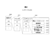
図2は、リンクテーブル200の構成を示す図である。リンクテーブル200は、地図の年代を特定可能な地図年代250で区分けされており、各年代について、地図上の区画された領域であるメッシュの識別コード(メッシュID)201ごとに、そのメッシュ領域に含まれる道路を構成する各リンクのリンクデータ202を含んでいる。すなわち、特定の年代のリンクデータを読み出し可能となっている。
FIG. 2 is a diagram showing the configuration of the link table 200. The link table 200 is divided by a
リンクデータ202は、リンクの識別子であるリンクID211ごとに、リンクを構成する2つのノード(開始ノード、終了ノード)の座標情報222、リンクを含む道路の種別を示す道路種別223、リンクの長さを示すリンク長224、予め記憶されたリンク旅行時間225、当該リンクの開始ノードに接続するリンクである開始接続リンクと、当該リンクの終了ノードに接続するリンクである終了接続リンクと、を特定する開始接続リンク、終了接続リンク226、リンクを含む道路の制限速度を示す制限速度227、などを含んでいる。
For each link ID 211 that is a link identifier, the
なお、ここでは、リンクを構成する2つのノードについて開始ノードと終了ノードとを区別することで、同じ道路の上り方向と下り方向とを、それぞれ別のリンクとして管理するようにしている。また、地図情報の作成年の地形に応じてリンクデータは作成されているため、道路の整備状況等により、異なる年代では異なるリンク、ノード、施設等が存在する場合がある。そのため、異なる年代間で道路状況に差異があれば、当該道路に対応するリンクIDやノードID等が削除されていたり、あらたにリンクIDやノードID等が追加されていたりする。その場合であっても、変更のない道路は、原則的には、同一のリンクIDやノードIDが維持されてリンクデータが構成される。 Here, by distinguishing the start node and the end node for the two nodes constituting the link, the upward direction and the downward direction of the same road are managed as different links. In addition, since link data is created according to the terrain of the map information creation year, different links, nodes, facilities, etc. may exist in different ages depending on the road maintenance situation. Therefore, if there is a difference in road conditions between different ages, a link ID, a node ID, or the like corresponding to the road is deleted, or a link ID, a node ID, or the like is newly added. Even in that case, in principle, the same link ID and node ID are maintained on the road without change, and the link data is configured.
図1に戻って説明する。音声入出力装置4は、音声入力装置としてマイクロフォン41と、音声出力装置としてスピーカ42と、を備える。マイクロフォン41は、使用者やその他の搭乗者が発した声などのナビゲーション装置100の外部の音声を取得する。
Returning to FIG. The voice input /
スピーカ42は、演算処理部1で生成された使用者へのメッセージ等の音声情報を音声として出力する。マイクロフォン41とスピーカ42は、車両の所定の部位に、別個に配されている。ただし、一体の筐体に収納されていても良い。ナビゲーション装置100は、マイクロフォン41及びスピーカ42を、それぞれ複数備えることができる。
The
入力装置5は、使用者からの指示を使用者による操作を介して受け付ける装置である。入力装置5は、タッチパネル51と、ダイヤルスイッチ52と、その他のハードスイッチ(図示しない)であるスクロールキー、縮尺変更キーなどで構成される。
The
タッチパネル51は、ディスプレイ2の表示面側に搭載され、表示画面を透視可能である。タッチパネル51は、ディスプレイ2に表示された画像のXY座標と対応したタッチ位置を特定し、タッチ位置を座標に変換して出力する。タッチパネル51は、感圧式または静電式の入力検出素子などにより構成される。
The
ダイヤルスイッチ52は、時計回り及び反時計回りに回転可能に構成され、所定の角度の回転ごとにパルス信号を発生し、演算処理部1に出力する。演算処理部1では、パルス信号の数から、回転角度を求める。
The
ROM装置6は、CD-ROMやDVD-ROM等のROM(Read Only Memory)や、IC(Integrated Circuit)カードといった、少なくとも読み取りが可能な記憶媒体で構成されている。この記憶媒体には、例えば、動画データや、音声データなどが記憶されている。
The
車速センサ7,ジャイロセンサ8およびGPS受信装置9は、ナビゲーション装置100で現在地(自車位置)を検出するために使用されるものである。車速センサ7は、車速を算出するのに用いる値を出力するセンサである。ジャイロセンサ8は、光ファイバジャイロや振動ジャイロ等で構成され、移動体の回転による角速度を検出するものである。GPS受信装置9は、GPS衛星からの信号を受信し移動体とGPS衛星間の距離と距離の変化率とを3個以上の衛星に対して測定することで移動体の現在地、進行速度および進行方位を測定するものである。
The
FM多重放送受信装置10は、FM放送局から送られてくるFM多重放送信号を受信する。FM多重放送には、VICS(Vehicle Information Communication System:登録商標)情報の概略現況交通情報、規制情報、SA/PA(サービスエリア/パーキングエリア)情報、駐車場情報、天気情報などやFM多重一般情報としてラジオ局が提供する文字情報などがある。
The FM
ビーコン受信装置11は、VICS情報などの概略現況交通情報、規制情報、SA/PA(サービスエリア/パーキングエリア)情報、駐車場情報、天気情報や緊急警報などを受信する。例えば、光により通信する光ビーコン、電波により通信する電波ビーコン等の受信装置である。
The
通信装置12は、図示しない無線通信網に接続する。このような通信装置12は、例えば携帯電話網に接続して外部の情報配信センター等のセンターのサーバとデータ通信を行う装置であり、例えば使用者の携帯電話機を取り付けられて通信が可能となるものを含む。
The
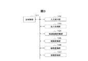
図3は、演算処理部1の機能ブロック図である。図示するように、演算処理部1は、主制御部101と、入力受付部102と、出力処理部103と、旧道経路探索部104と、経路探索部105と、経路置換部106と、経路誘導部107と、を有する。
FIG. 3 is a functional block diagram of the arithmetic processing unit 1. As illustrated, the arithmetic processing unit 1 includes a
主制御部101は、様々な処理を行う中心的な機能部であり、処理内容に応じて、他の処理部を制御する。また、各種センサ7、8、GPS受信装置9等の情報を取得し、マップマッチング処理等を行って現在地を特定する。また、随時、走行した日付および時刻と、位置と、を対応付けて、リンクごとに走行履歴を記憶装置3に記憶する。さらに、各処理部からの要求に応じて、GPS受信装置9によって受信したGPS情報に含まれる現在時刻を出力する。また、主制御部101は、他の処理部から推奨経路の情報を要求されると、当該情報を出力する。
The
入力受付部102は、入力装置5またはマイクロフォン41を介して入力された使用者からの指示を受け付け、その要求内容に対応する処理が実行されるように、受け付けた要求内容を主制御部101に出力する。例えば、使用者が推奨経路の探索を要求したときは、受け付けた推奨経路の探索要求を主制御部101へ出力する。
また、所定の機能メニュー画面がディスプレイ2に表示されている状態で、メニュー内の様々な操作について、タッチパネル51を介して入力を受け付ける。
The
In addition, in a state where a predetermined function menu screen is displayed on the
出力処理部103は、例えば表示させる画面情報を受け取り、ディスプレイ2に描画するためのグラフィックス情報に変換して、ディスプレイ2に対して描画する指示を行う。また、処理内容に応じて、スピーカ42から出力する指示を行う。
The
旧道経路探索部104は、使用者から指示された年代における、出発地又は現在地と、目的地と、を結ぶ最適な経路(以降、「オリジナル経路」という)を探索する。当該経路探索においては、旧道経路探索部104は、指示された年代の地図を適用し、ダイクストラ法等の経路探索ロジックを用いて、道路の所定の区間(リンク)に対して予め設定されたリンクコストに基づいて経路を探索する。
The old road
経路探索部105は、現在の年代のリンクデータを用いて、出発地又は現在地と、目的地と、を結ぶ最適な経路(推奨経路)を探索する。当該経路探索においては、ダイクストラ法等の経路探索ロジックを用いて、道路の所定の区間(リンク)に対して予め設定されたリンクコストに基づいて経路を探索する。なお、経路探索部105は、経路探索の際に、現在の日時に基づいて予測した到着日時・日の種類に対応する統計情報に含まれるリンクコストを用いて探索するようにしてもよい。
The
経路置換部106は、旧道経路探索部104により経路探索した年代におけるオリジナル経路を、現在の年代における推奨経路に置き換える。当該置き換え処理においては、経路置換部106は、オリジナル経路を構成するリンク及びノードを、現在の年代における同一のリンクおよびノードに対応付けができるか否かを判定し、対応づけできない場合には、オリジナル経路を構成するリンクあるいはノードに近い現在の年代のリンクあるいはノードに対応づけて置き換える。なお、経路置換部106は、オリジナル経路を構成するリンクあるいはノードのうち、リンクIDあるいはノードIDが現在の年代におけるリンクIDおよびノードIDと同一のものについては、対応付けができるものと判定し、そうでない場合には、対応づけができないものと判定する。
The
経路誘導部107は、車両の現在地が推奨経路から逸脱しないよう、誘導情報を生成し、出力処理部103へ出力する。
The
上記した演算処理部1の各機能部、すなわち主制御部101、入力受付部102、出力処理部103、旧道経路探索部104、経路探索部105、経路置換部106、経路誘導部107は、CPU21が所定のプログラムを読み込み実行することにより構築される。そのため、RAM22には、各機能部の処理を実現するためのプログラムが記憶されている。
The functional units of the arithmetic processing unit 1 described above, that is, the
なお、上記した各構成要素は、ナビゲーション装置100の構成を、理解を容易にするために、主な処理内容に応じて分類したものである。そのため、構成要素の分類の仕方やその名称によって、本願発明が制限されることはない。ナビゲーション装置100の構成は、処理内容に応じて、さらに多くの構成要素に分類することもできる。また、1つの構成要素がさらに多くの処理を実行するように分類することもできる。
In addition, each above-mentioned component is classified according to the main processing content, in order to make an understanding easy the structure of the
また、各機能部は、ハードウェア(ASIC、GPUなど)により構築されてもよい。また、各機能部の処理が一つのハードウェアで実行されてもよいし、複数のハードウェアで実行されてもよい。 Each functional unit may be constructed by hardware (ASIC, GPU, etc.). Further, the processing of each functional unit may be executed by one hardware or may be executed by a plurality of hardware.
[動作の説明]次に、ナビゲーション装置100が実施する旧道経路探索処理の動作について説明する。図4は、ナビゲーション装置100が実施する旧道経路探索処理を示すフロー図である。このフローは、ナビゲーション装置100が稼働している状態において、所定の機能メニュー表示画面が操作されると開始される。
[Description of Operation] Next, the operation of the old road route search process performed by the
まず、入力受付部102は、タッチパネル51等を介して検知した年代を指定する入力情報を受け付けて主制御部101へ入力された内容を出力する(ステップS001)。そして、主制御部101は、入力受付部102、出力処理部103、旧道経路探索部104、経路探索部105、経路置換部106、経路誘導部107に順次指示を出して、以下の処理を実行させる。
First, the
まず、主制御部101は、指定を受け付けた年代に対応するリンクデータをロードする(ステップS002)。具体的には、主制御部101は、旧道経路探索部104に対して、ステップS001で受け付けた年代に応じたリンクデータを、リンクテーブル200から読み出し、経路探索に用いることができるようロードするよう指示する。旧道経路探索部104は、当該指示を受け付けると、該当する年代のリンクデータを適用するようロードする。
First, the
そして、入力受付部102は、タッチパネル51等を介して検知した目的地を指定する入力情報を受け付けて、主制御部101へ入力された内容を出力する(ステップS003)。主制御部101は、旧道経路探索部104に目的地を出力し、旧道経路探索部104は目的地の情報を受け取る。
Then, the
そして、旧道経路探索部104は、主制御部101から現在地の情報を取得する(ステップS004)。そして、旧道経路探索部104は、ロードされた年代の地図において、ステップS004にて取得した現在地からステップS003で受け付けた目的地へ到る経路を探索し、探索された推奨経路をオリジナル経路とする(ステップS005)。なお、旧道経路探索部104は、ロードされた年代の地図を適用し、ダイクストラ法等の経路探索ロジックを用いて、所定のリンクおよびノードに対して予め設定されたコストに基づいて経路を探索する。
Then, the old road
経路置換部106は、オリジナル経路のうち、現在の年代のリンクデータに置換できない置換不能区間を特定する(ステップS006)。具体的には、経路置換部106は、オリジナル経路を構成するリンクとノードのうち、現在の年代のリンクデータに含まれないものを抽出する。そして、経路置換部106は、抽出したリンクとノードのうち、連続するものをつなげて、つなげた単位を置換不能区間として特定する。
The
経路探索部105は、現在の年代のリンクデータを適用できるように、ロードする(ステップS007)。なお、現在の年代のリンクデータが記憶装置3に格納されていない場合には、最新のリンクデータを現在の年代のリンクデータとする。
The
そして、経路探索部105は、ロードした現在の年代のリンクデータを用いて、置換不能区間ごとに、当該置換不能区間の始点から終点へ到る経路を探索する(ステップS008)。具体的には、経路探索部105は、置換不能区間ごとに、当該区間の始点から終点へ到る経路を、ロードされた現在の年代の地図を適用して、ダイクストラ法等の経路探索ロジックにより、当該置換不能区間を置換するための代替経路として探索する。
Then, the
経路探索部105は、置換不能区間については、ステップS008で探索した代替経路に置き換えて、置換不能区間以外の区間については、当該区間の経路を適用して、各区間をつなげて経路を合成し、合成した経路を現行経路として特定する(ステップS009)。
The
次に、旧道経路探索部104は、ステップS005にて探索したオリジナル経路と、ステップS009にて合成した現行経路と、を一覧することができる経路確認画面の表示情報を構成し、当該表示情報を出力処理部103に出力する。出力処理部103は、受け取った表示情報をディスプレイ2に表示させる。あわせて旧道経路探索部104は、現行経路を推奨経路として設定する(ステップS010)。
Next, the old road
図5(a)は、ナビゲーション装置100のメニュー画面の一部である、目的地設定画面400の例を示す図である。目的地設定画面400は、通常の目的地設定を行う指示を受け付けるための通常指定ボタン401と、年代を指定して旧道経路探索を行うための年代指定ボタン402と、を備える。ここで、年代指定ボタン402への入力指示を受け付けると、旧道経路探索処理が、ステップS001から開始される。
FIG. 5A is a diagram illustrating an example of the
図5(b)は、旧道経路探索処理のステップS001にて年代の指定を受け付ける年代指定画面410の例を示す図である。年代指定画面410は、年代を指定するための数値入力を受け付ける数値入力キーボタン411と、指定された年代を表示する指定年代領域412と、入力した年代を確定させるための入力指定を受け付けるOKボタン413と、を含んで構成される。使用者は、数値入力キーボタン411のいずれかの数値を4桁指定入力することで、年代を指定し、OKボタン413を指定入力することで、入力した年代を確定させて、旧道による経路探索処理を開始させることができる。
FIG. 5B is a diagram showing an example of the
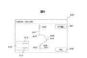
図6は、旧道経路探索処理のステップS010にて表示される経路確認画面500の例を示す図である。経路確認画面500には、現在地を示すカーマーク501と、目的地を示す目的地アイコン502と、カーマーク501の位置から目的地アイコン502の位置へ到る経路を表示する領域が含まれる。当該経路として、オリジナル経路と、現行経路と、が表示される。両経路は、経路ごとに判別可能に実線または破線で表示される。図6では、例えば、交差点505から交差点506へ到る区間が置換不能区間508である例を示している。当該置換不能区間508については、代替経路504が現在の年代のリンクデータを利用して探索された結果、推奨経路として表示されている。なお、経路確認画面500には、凡例表示領域510と、やり直しの指示入力を受け付けるやり直しボタン521と、当該推奨経路に基づく経路誘導を開始するよう指示する入力を受け付けるOKボタン522と、が表示されている。凡例表示領域510には、現在の年代512と、指定された年代511とが、それぞれの年代の経路を示す線の表現と対応付けられて表示される。
FIG. 6 is a diagram showing an example of the
次に、図7を用いて、旧道経路探索処理のステップS008において経路探索部105によりなされる代替経路の探索の概念を説明する。図7は、現在地601から目的地602へ到る経路が、現在地が存在するリンク603、リンク603の終点ノードであるノード606、ノード606〜ノード607を直接接続するリンク604、ノード607を始点として目的地602を終点とするリンク605、により構成されていることを示す図である。ただし、リンク604は、旧道であり、ある過去の時代には存在した道路であるが、現在の年代までの間に当該リンクは廃道となり、代わりにノード608を通る経路すなわち2リンクから構成される経路と、ノード609およびノード610の二つのノードを通る経路すなわち3リンクから構成される経路と、が新たに設けられたものとする。
Next, the concept of the alternative route search performed by the
ここで、リンク604は、現在の時代の経路と対応づけが可能なリンクではないため、経路置換部106は、当該リンクを置換不能区間とする。そして、リンク603、リンク605は、現在の時代の経路と対応付けが可能なリンクである。このような場合には、経路置換部106は、当該置換不能区間すなわちノード606からノード607に到る経路に代替しうる経路を、リンク数が少ないものから選ぶ。具体的には、ノード606とノード608をつなぐリンク、および、ノード608とノード607をつなぐリンク、からなる経路は、リンクの数が2である。一方、ノード606とノード609をつなぐリンク、ノード609とノード610をつなぐリンク、および、ノード610とノード607をつなぐリンクからなる経路は、リンクの数が3である。したがって、経路置換部106は、リンクの数が2である前者の経路を、代替経路として選ぶ。なお、ダイクストラ法では、リンクのコストをその性質にかかわらず全て1とするよう重み付けを行うことで、同様の代替経路の探索を実現することができる。
Here, since the
上記の概念により、各置換不能区間について、代替経路を現在の年代のリンクデータを用いて求め、つなぎ合わせることで、旧道になるべく近い道路を現在の地図上で誘導することができるようになる。 Based on the above concept, for each non-replaceable section, an alternative route is obtained by using link data of the current age, and by connecting them, a road as close as possible to the old road can be guided on the current map.
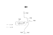
図8は、このような経路誘導の例について、概要を説明するための図である。図8には、現在地701から目的地702へ到る経路のうち、オリジナル経路(例えば1980年の経路)である旧道を用いた点線で示す経路704と、オリジナル経路を現在(例えば2010年)の年代の地図上に置き変えた実線で示す経路703と、が示されている。なお、オリジナル経路である経路704沿いには、かつて存在した遊園地705の跡地があるものとする。このような場合に、経路誘導部107は、遊園地705の跡地から最も近い位置において、かつて付近に遊園地があったことを知らせるメッセージ706を出力する。このメッセージは、画面上で文字列として表示するようにしても良いし、音声により出力しても良いし、その両方で出力するようにしても良い。
FIG. 8 is a diagram for explaining the outline of an example of such route guidance. In FIG. 8, among the routes from the
以上が、本発明に係る第一の実施形態である。第一の実施形態によれば、ナビゲーション装置100は、古い年代で探索された経路を、現在の年代の地図上で再現することが可能となる。また、経路誘導部107が、再現した推奨経路に従って経路の誘導情報を生成し、出力することができる。そのため、ナビゲーション装置100は、古い年代の地図情報を用いて経路を探索し、誘導することができるといえる。
The above is the first embodiment according to the present invention. According to the first embodiment, the
次に、図9、図10を用いて、本発明に係る第二の実施形態を説明する。第二の実施形態においては、基本的に第一の実施形態と同様の構成を備えるが、一部において相違する。以下、その相違点を中心に説明する。 Next, a second embodiment according to the present invention will be described with reference to FIGS. The second embodiment basically has the same configuration as the first embodiment, but is partially different. Hereinafter, the difference will be mainly described.
図9は、第二の実施形態にかかるナビゲーション装置100が実施する旧道経路探索処理を示すフロー図である。このフローは、第一の実施形態に係る旧道経路探索処理のフローと基本的に同様であるが、ステップS005を実施した後の処理に相違があるため、その説明を以下に行う。
FIG. 9 is a flowchart showing an old road route search process performed by the
ステップS005において、旧道経路探索部104がオリジナル経路を探索した後、経路置換部106は、オリジナル経路を構成するノードの位置を座標等によりそれぞれ特定する(ステップS106)。
In step S005, after the old road
次に、経路探索部105は、現在の年代のリンクデータを適用できるように、ロードする(ステップS107)。
Next, the
そして、経路置換部106は、ロードした現在の年代のリンクデータを用いて、特定したノードの位置から所定の距離内にあるリンクおよびノードのコストを重み付けする(ステップS108)。具体的には、経路置換部106は、ステップS106にて特定した各ノードの位置から所定の距離内に存在するリンクおよびノードのリンクコストを、所定量あるいは所定の割合で減少させて、他のリンクあるいはノードよりもコスト上有利なように設定する。なお、経路置換部106は、リンクコストを減少させる処理において、ステップS106にて特定した各ノードの位置からの距離が近いほど、コストの減少割合の幅を大きくするようにしてもよい。
Then, the
そして、経路探索部105は、ステップS108において重み付けを行ったコストを用いて、現在地から目的地へ到る経路探索を行う。そして、得られた経路の情報を、現行経路として特定する(ステップS109)。
Then, the
次に、旧道経路探索部104は、ステップS005にて探索したオリジナル経路と、ステップS109にて探索した現行経路と、を一覧することができる経路確認画面の表示情報を構成し、当該表示情報を出力処理部103に出力する。出力処理部103は、受け取った表示情報をディスプレイ2に表示させる。あわせて旧道経路探索部104は、現行経路を推奨経路として設定する(ステップS110)。
Next, the old road
次に、図10を用いて、第二の実施形態における旧道経路探索処理のステップS108において経路置換部106によりなされるコストの重み付けの具体例を説明する。図10(a)は、その具体例の一つを示す図である。現在地801から目的地802へ到る経路が、現在地が存在するリンク803、リンク803の終点ノードであるノード806、ノード806からノード807を接続する区間804、ノード807を始点として目的地802を終点とするリンク805、により構成されていることを示す。なお、区間804には、ノード808およびノード809が含まれているものとする。ただし、リンク804は、旧道であり、ある過去の時代には存在した道路であるが、現在の年代までの間に当該リンクは廃道となり、代わりにノード810およびノード811を通る経路が新たに設けられたものとする。
Next, a specific example of the weighting of the cost performed by the
このような場合において、経路置換部106は、ノード808およびノード809のそれぞれから、所定の距離内の領域に含まれるリンクおよびノードのコストを、一定割合で、あるいは一定の値だけ、減少させる。すなわち、経路置換部106は、ノード808から所定の距離内の領域820に含まれるノード810のコストを下げ、当該ノードを開始ノードまたは終了ノードとするリンクのコストを下げる。また、経路置換部106は、ノード808から所定の距離内の領域820よりも外側の所定の距離内の領域821に含まれるノードおよび当該ノードに接続するリンクがあれば、当該ノードおよびリンクのコストを減少させる。この場合には、よりノード808に近い領域820に含まれるノードおよび当該ノードに接続するリンクのコストの減少率は、領域821に含まれるノードおよび当該ノードに接続するリンクのコストの減少率より大きくなるものとする。同様に、ノード809についても、ノード809に近い領域830に含まれるノードおよび当該ノードに接続するリンクのコストの減少率は、領域831に含まれるノードおよび当該ノードに接続するリンクのコストの減少率より大きくなるものとする。
In such a case, the
図10(b)は、図10(a)とは別の具体例の一つを示す図である。図10(b)は、原則、図10(a)に示すのと同様の構成であるが、コストを減少させる領域の設定の仕方に相違がある。図10(b)に挙げている例では、経路置換部106は、ノード808、ノード809の二点を焦点とする所定の短半径を備える楕円の領域840を設け、当該領域に含まれるリンクおよびノードのコストを、一定割合で、あるいは一定の値だけ、減少させる。すなわち、経路置換部106は、ノード808およびノード809を焦点とする所定の短半径を備える楕円の領域840に含まれるノード810のコストを下げ、当該ノードを開始ノードまたは終了ノードとするリンクのコストを下げる。また、経路置換部106は、楕円の領域840よりも外側の所定の短半径を備える領域841に含まれるノードおよび当該ノードに接続するリンクがあれば、当該ノードおよびリンクのコストを減少させる。この場合には、より短半径が短い領域840に含まれるノード(図10(b)においては、ノード810)および当該ノードに接続するリンクのコストの減少率は、短半径が長い領域841に含まれるノード(図10(b)においては、ノード811)および当該ノードに接続するリンクのコストの減少率より大きくなるものとする。
FIG. 10B is a diagram showing one specific example different from FIG. FIG. 10B is basically the same configuration as that shown in FIG. 10A, but there is a difference in how to set an area for reducing the cost. In the example illustrated in FIG. 10B, the
以上、第二の実施形態について、第一の実施形態との相違を中心に説明した。本発明の第二の実施形態によると、ナビゲーション装置100は、第一の実施形態に比べて、よりオリジナル経路に近い位置にある経路が探索される可能性が高くなる。そのため、オリジナル経路を可能な限りなぞるような経路誘導を受けたい場合に、より高い効果を奏することができる。
The second embodiment has been described above with a focus on differences from the first embodiment. According to the second embodiment of the present invention, the
本発明は、上記第一の実施形態および第二の実施形態に制限されない。上記第一の実施形態および第二の実施形態は、本発明の技術的思想の範囲内で様々な変形が可能である。例えば、予め地図を所定のルールに従って区分けしておき、オリジナル経路と同じ区分けに属するノードやリンクのコストを一律に減少させるようにしてもよい。このようにすることで、演算処理負荷の軽減が可能となり、応答性を高めることができるようになる。 The present invention is not limited to the first embodiment and the second embodiment. The first embodiment and the second embodiment can be variously modified within the scope of the technical idea of the present invention. For example, the map may be classified in advance according to a predetermined rule, and the costs of nodes and links belonging to the same classification as the original route may be reduced uniformly. By doing so, it is possible to reduce the arithmetic processing load and to improve the responsiveness.
以上、本発明について、実施形態を中心に説明した。なお、上記の実施形態では、本発明を車載ナビゲーション装置に適用した例について説明したが、本発明はナビゲーション装置に限らず、移動体の経路案内を行う装置全般に適用することができる。 In the above, this invention was demonstrated centering on embodiment. In the above embodiment, an example in which the present invention is applied to an in-vehicle navigation device has been described. However, the present invention is not limited to a navigation device, but can be applied to any device that performs route guidance for a moving body.
1・・・演算処理部、2・・・ディスプレイ、3・・・記憶装置、4・・・音声出入力装置、5・・・入力装置、6・・・ROM装置、7・・・車速センサ、8・・・ジャイロセンサ、9・・・GPS受信装置、10・・・FM多重放送受信装置、11・・・ビーコン受信装置、12・・・通信装置、21・・・CPU、22・・・RAM、23・・・ROM、24・・・I/F、25・・・バス、41・・・マイクロフォン、42・・・スピーカ、51・・・タッチパネル、52・・・ダイヤルスイッチ、100・・・ナビゲーション装置、101・・・主制御部、102・・・入力受付部、103・・・出力処理部、104・・・旧道経路探索部、105・・・経路探索部、106・・・経路置換部、107・・・経路誘導部、200・・・リンクテーブル DESCRIPTION OF SYMBOLS 1 ... Arithmetic processing part, 2 ... Display, 3 ... Memory | storage device, 4 ... Voice output device, 5 ... Input device, 6 ... ROM device, 7 ... Vehicle speed sensor , 8 ... Gyro sensor, 9 ... GPS receiver, 10 ... FM multiplex broadcast receiver, 11 ... Beacon receiver, 12 ... Communication device, 21 ... CPU, 22 ... RAM, 23 ... ROM, 24 ... I / F, 25 ... bus, 41 ... microphone, 42 ... speaker, 51 ... touch panel, 52 ... dial switch, 100. ..Navigation device, 101... Main control unit, 102... Input reception unit, 103... Output processing unit, 104 ... old road route search unit, 105. Route replacement unit, 107 ... Route guidance unit, 200 Link table
Claims (11)
出発地を特定する出発地特定手段と、
年代の指定と、目的地の指定と、を受け付ける受付手段と、
前記地図情報のうち、前記受付手段により受け付けた年代に対応付けられた地図情報を用いて、前記出発地から前記目的地へ到る第一の経路を探索する第一の経路探索手段と、
前記第一の経路を、前記指定された年代と異なる第二の年代に対応付けられた地図情報において対応付けを試みる対応付け手段と、
前記第一の経路のうち、前記対応付け手段によって対応付けができない部分について、前記第二の年代に対応付けられた地図情報を用いて経路を探索して置き換えることで、第二の経路を探索する第二の経路探索手段と、
前記第二の経路を表示させる表示手段と、
を備えることを特徴とするナビゲーション装置。 Storage means for storing map information associated with a plurality of ages;
A starting point specifying means for specifying a starting point;
An accepting means for accepting designation of the age and designation of the destination;
Of the map information, a first route search means for searching for a first route from the departure place to the destination using map information associated with the age received by the reception means;
Association means for attempting to associate the first route with map information associated with a second age different from the designated age;
Search the second route by searching for and replacing the portion of the first route that cannot be matched by the matching means using the map information associated with the second age. Second route searching means for
Display means for displaying the second route;
A navigation device comprising:
前記表示手段は、前記第二の経路に加えて、さらに、前記第一の経路を表示させる、
ことを特徴とするナビゲーション装置。 The navigation device according to claim 1,
In addition to the second route, the display means further displays the first route.
A navigation device characterized by that.
前記対応付け手段は、前記第一の経路を構成する所定の部分が、前記第二の年代に対応付けられた地図情報に含まれない場合には、当該部分は対応付けができない部分であるとする、
ことを特徴とするナビゲーション装置。 The navigation device according to claim 1 or 2,
If the predetermined part constituting the first route is not included in the map information associated with the second age, the associating means is a part that cannot be associated. To
A navigation device characterized by that.
前記第二の経路探索手段は、前記対応付けができない部分についての経路探索処理において、前記第一の経路の周囲にある道路のコストを下げて経路を探索する、
ことを特徴とするナビゲーション装置。 The navigation device according to any one of claims 1 to 3,
The second route search means searches for a route by reducing the cost of a road around the first route in the route search process for the portion that cannot be associated,
A navigation device characterized by that.
前記第二の経路探索手段は、前記第一の経路を構成する道路上の所定の地点を基準とする所定の範囲に含まれる道路を、前記第一の経路の周囲にある道路とする、
ことを特徴とするナビゲーション装置。 The navigation device according to claim 4,
The second route search means, a road included in a predetermined range based on a predetermined point on the road constituting the first route is a road around the first route,
A navigation device characterized by that.
前記第二の経路探索手段は、前記第一の経路の周囲にある道路のコストを下げて経路を探索する処理において、前記第一の経路を構成する道路上の所定の地点からの距離が近いほど、前記第一の経路の周囲にある道路のコストを大幅に下げる、
ことを特徴とするナビゲーション装置。 The navigation device according to claim 4 or 5, wherein
In the process of searching for a route by reducing the cost of a road around the first route, the second route searching means is close to a predetermined point on the road constituting the first route. The cost of the road around the first route is greatly reduced,
A navigation device characterized by that.
前記第一の経路を構成する道路上の所定の地点は、前記第一の経路を構成する道路を構成するリンクの接続点である、
ことを特徴とするナビゲーション装置。 The navigation device according to claim 5 or 6, wherein
The predetermined point on the road constituting the first route is a connection point of links constituting the road constituting the first route.
A navigation device characterized by that.
前記第一の経路を構成する道路上の所定の地点は、前記第一の経路を構成する道路を構成するリンクの接続点が複数ある場合には、隣接する二つの接続点であり、
前記所定の範囲は、前記二つの接続点を二焦点とする楕円の範囲により特定される、
ことを特徴とするナビゲーション装置。 The navigation device according to claim 5 or 6, wherein
The predetermined point on the road constituting the first route is two adjacent connection points when there are a plurality of link connection points constituting the road constituting the first route,
The predetermined range is specified by an ellipse range having the two connection points as two focal points.
A navigation device characterized by that.
前記表示手段は、地図上に、前記第一の経路と、前記第二の経路と、を表示するとともに、当該第一の経路と対応付けて第一の年代を表示する、
ことを特徴とするナビゲーション装置。 The navigation device according to any one of claims 1 to 8,
The display means displays the first route and the second route on a map, and displays the first age in association with the first route.
A navigation device characterized by that.
前記記憶手段には、前記年代ごとに、施設と、当該施設を説明する情報が記憶されており、
前記第一の経路のうち、前記対応付け手段によって対応付けができない部分の周囲にある施設を特定し、当該施設を説明する情報を前記記憶手段から読み出して表示する経路誘導手段を備える、
ことを特徴するナビゲーション装置。 The navigation device according to any one of claims 1 to 9, further comprising:
In the storage means, for each age, facilities and information explaining the facilities are stored,
A route guidance unit that identifies a facility around a portion of the first route that cannot be associated by the association unit, and that reads and displays information describing the facility from the storage unit;
A navigation device characterized by that.
前記ナビゲーション装置は、
複数の年代に対応づけられた地図情報を記憶する記憶手段と、
出発地を特定する出発地特定手段と、
年代の指定と、目的地の指定と、を受け付ける受付手段と、を備え、
前記地図情報のうち、前記受付手段により受け付けた年代に対応付けられた地図情報を用いて、前記出発地から前記目的地へ到る第一の経路を探索する第一の経路探索ステップと、
前記第一の経路を、前記指定された年代と異なる第二の年代に対応付けられた地図情報において対応付けを試みる対応付けステップと、
前記第一の経路のうち、前記対応付けステップにおいて対応付けができない部分について、前記第二の年代に対応付けられた地図情報を用いて経路を探索して置き換えることで、第二の経路を探索する第二の経路探索ステップと、
前記第二の経路を表示させる表示ステップと、
を実施することを特徴とするナビゲーション方法。 A navigation method for a navigation device, comprising:
The navigation device
Storage means for storing map information associated with a plurality of ages;
A starting point specifying means for specifying a starting point;
Receiving means for accepting designation of the age and designation of the destination,
Of the map information, a first route search step for searching for a first route from the departure point to the destination using map information associated with the age received by the receiving unit;
An association step of attempting to associate the first route with map information associated with a second age different from the designated age;
The second route is searched by searching for and replacing the portion of the first route that cannot be matched in the matching step by using the map information associated with the second age. A second route search step to:
A display step of displaying the second route;
The navigation method characterized by implementing.
Priority Applications (1)
| Application Number | Priority Date | Filing Date | Title |
|---|---|---|---|
| JP2010106301A JP2011237188A (en) | 2010-05-06 | 2010-05-06 | Navigation device and navigation method thereof |
Applications Claiming Priority (1)
| Application Number | Priority Date | Filing Date | Title |
|---|---|---|---|
| JP2010106301A JP2011237188A (en) | 2010-05-06 | 2010-05-06 | Navigation device and navigation method thereof |
Publications (1)
| Publication Number | Publication Date |
|---|---|
| JP2011237188A true JP2011237188A (en) | 2011-11-24 |
Family
ID=45325352
Family Applications (1)
| Application Number | Title | Priority Date | Filing Date |
|---|---|---|---|
| JP2010106301A Pending JP2011237188A (en) | 2010-05-06 | 2010-05-06 | Navigation device and navigation method thereof |
Country Status (1)
| Country | Link |
|---|---|
| JP (1) | JP2011237188A (en) |
Cited By (1)
| Publication number | Priority date | Publication date | Assignee | Title |
|---|---|---|---|---|
| JP2023011414A (en) * | 2021-07-12 | 2023-01-24 | トヨタ自動車株式会社 | Method for generating operation routes, program, and operation route generator |
-
2010
- 2010-05-06 JP JP2010106301A patent/JP2011237188A/en active Pending
Cited By (2)
| Publication number | Priority date | Publication date | Assignee | Title |
|---|---|---|---|---|
| JP2023011414A (en) * | 2021-07-12 | 2023-01-24 | トヨタ自動車株式会社 | Method for generating operation routes, program, and operation route generator |
| JP7571679B2 (en) | 2021-07-12 | 2024-10-23 | トヨタ自動車株式会社 | Travel route generation method, program, and travel route generation device |
Similar Documents
| Publication | Publication Date | Title |
|---|---|---|
| JP4377246B2 (en) | Information processing apparatus, system thereof, method thereof, program thereof, and recording medium recording the program | |
| JP5492694B2 (en) | Navigation device, program, and display method | |
| JP4159372B2 (en) | GUIDANCE GUIDANCE SYSTEM, TERMINAL DEVICE, GUIDANCE GUIDANCE METHOD, PROGRAM THEREOF, AND RECORDING MEDIUM CONTAINING THE PROGRAM | |
| JP2010197211A (en) | Server apparatus, navigation apparatus, route information presentation system and route information presentation method | |
| WO2006001414A1 (en) | Traffic situation display device, method and program thereof and recording medium with the program recorded therein | |
| EP2770299B1 (en) | Information terminal and program | |
| JP2016218361A (en) | Speech recognition system, in-vehicle device, and server device | |
| JP5149097B2 (en) | Navigation device and route search method | |
| JP5448626B2 (en) | Navigation device, server device, and navigation system | |
| JP2012037402A (en) | Route output device and output method thereof | |
| WO2010113909A1 (en) | Map display device and map image display method of map display device | |
| JP5607389B2 (en) | Navigation device and map update guidance method thereof | |
| JP2011237188A (en) | Navigation device and navigation method thereof | |
| JP2013156216A (en) | Navigation device, software update program, and update method | |
| JP4036762B2 (en) | MAP INFORMATION PROCESSING DEVICE, ITS SYSTEM, ITS METHOD, ITS PROGRAM, AND RECORDING MEDIUM CONTAINING THE PROGRAM | |
| JP4696253B2 (en) | Travel route setting device, travel route notification device, and travel route notification system | |
| JP2010127770A (en) | Navigation device and navigation method | |
| JP4533586B2 (en) | Map information processing system, method thereof, program thereof, and recording medium recording the program | |
| JP2007033209A (en) | Navigation device | |
| JP5492455B2 (en) | Navigation device | |
| JP5219656B2 (en) | Traffic information distribution device, traffic information distribution system, and distribution method | |
| JP2012127708A (en) | Navigation device and route search method | |
| JP2013160529A (en) | Information terminal, program and map display method | |
| JP2010038823A (en) | Navigation apparatus, and map display method | |
| JP4355499B2 (en) | MAP INFORMATION PROCESSING DEVICE, ITS SYSTEM, ITS METHOD, ITS PROGRAM, AND RECORDING MEDIUM CONTAINING THE PROGRAM |