JP2017203733A - Cruisable range display device, cruisable range display method and program - Google Patents
Cruisable range display device, cruisable range display method and program Download PDFInfo
- Publication number
- JP2017203733A JP2017203733A JP2016096730A JP2016096730A JP2017203733A JP 2017203733 A JP2017203733 A JP 2017203733A JP 2016096730 A JP2016096730 A JP 2016096730A JP 2016096730 A JP2016096730 A JP 2016096730A JP 2017203733 A JP2017203733 A JP 2017203733A
- Authority
- JP
- Japan
- Prior art keywords
- cruising
- range
- time point
- cruising range
- predicted
- Prior art date
- Legal status (The legal status is an assumption and is not a legal conclusion. Google has not performed a legal analysis and makes no representation as to the accuracy of the status listed.)
- Granted
Links
- 238000000034 method Methods 0.000 title claims abstract description 30
- 238000012545 processing Methods 0.000 claims abstract description 79
- 239000000446 fuel Substances 0.000 claims description 33
- 230000010365 information processing Effects 0.000 claims description 11
- 230000015572 biosynthetic process Effects 0.000 claims description 5
- 238000012937 correction Methods 0.000 claims description 5
- 230000002093 peripheral effect Effects 0.000 claims description 5
- 238000000605 extraction Methods 0.000 description 5
- 238000005259 measurement Methods 0.000 description 2
- 241000239290 Araneae Species 0.000 description 1
- 230000005540 biological transmission Effects 0.000 description 1
- 238000010586 diagram Methods 0.000 description 1
- 230000000694 effects Effects 0.000 description 1
- 239000000284 extract Substances 0.000 description 1
- 238000012986 modification Methods 0.000 description 1
- 230000004048 modification Effects 0.000 description 1
- 230000003068 static effect Effects 0.000 description 1
Images




Landscapes
- Navigation (AREA)
Abstract
Description
本発明は、車両の航続可能範囲を表示する航続可能範囲表示装置、航続可能範囲表示方法及びプログラムに関する。 The present invention relates to a cruising range display device that displays a cruising range of a vehicle, a cruising range display method, and a program.
車両の航続可能範囲を地図上に蜘蛛の巣状に表示する技術が知られている(例えば、特許文献1参照)。特許文献1には、バッテリ残量などの航続余力に応じて詳細度の異なる複数の道路地図データを使い分けて航続可能経路を求めることで、該航続可能経路を演算により求める際の負荷を低減し得る技術が開示されている。具体的には、バッテリ残量が第1閾値(10%)未満では、最も詳細な第3道路地図データを選択し、第1閾値(10%)以上第2閾値(20%)未満では、第3道路地図データよりも詳細度が低い第2道路地図データを選択し、第2閾値(20%)以上では、第2道路地図データよりも詳細度が低い第1道路地図データを選択することが記載されている(段落[0047]〜[0049])。これにより、詳細度の高い第3道路地図データのみによって航続可能経路を求める場合と比較して演算負荷を低減させることができる。 A technique for displaying a cruising range of a vehicle in a spider web shape on a map is known (see, for example, Patent Document 1). In Patent Document 1, by using a plurality of road map data having different levels of detail according to the remaining cruising capacity such as a battery remaining amount and obtaining a cruising route, the load when calculating the cruising route is reduced. Obtaining techniques are disclosed. Specifically, when the remaining battery level is less than the first threshold value (10%), the most detailed third road map data is selected, and when the remaining battery level is greater than or equal to the first threshold value (10%) and less than the second threshold value (20%), It is possible to select the second road map data having a lower level of detail than the three road map data, and to select the first road map data having a lower level of detail than the second road map data at a second threshold (20%) or more. (Paragraphs [0047] to [0049]). Thereby, it is possible to reduce the calculation load as compared with a case where a cruising route is obtained only from the third road map data having a high degree of detail.
しかしながら、移動を伴う車両の航続可能範囲を求める場合、車両の移動に対応すべく、繰り返し(例えば、定期的に)同じ処理(例えば、前述した演算等)を行っていた。そのため、前述したように、詳細度が低い道路地図データを用いることで処理の負荷が低減されるとはいえ、該道路地図データにおける広範囲の道路ネットワークについて繰り返し同じ処理を行わなければならない為、航続可能範囲を求める際の処理の負荷は依然として大きい。 However, when determining the cruising range of a vehicle that accompanies movement, the same processing (for example, the above-described calculation or the like) is performed repeatedly (for example, periodically) to cope with the movement of the vehicle. Therefore, as described above, although the processing load is reduced by using road map data with a low level of detail, the same processing must be repeated for a wide range of road networks in the road map data. The processing load when determining the possible range is still large.
本発明は、このような事情に鑑みてなされたもので、車両の航続可能範囲を求める際の処理の負荷を飛躍的に低減させることができる航続可能範囲表示装置、航続可能範囲表示方法及びプログラムを提供するものである。 The present invention has been made in view of such circumstances, and a cruising range display device, a cruising range display method, and a program capable of dramatically reducing the processing load when determining the cruising range of a vehicle. Is to provide.
本発明に係る航続可能範囲表示装置は、車両の航続可能範囲を表示する航続可能範囲表示装置であって、道路ネットワークを構成する複数のノードと前記複数のノードの各々についての過去の時点での予測航続余力値とが関連づけられた予測情報を記憶する記憶手段と、前記記憶手段から前記予測情報を読み出して前記過去の時点での予測航続余力値を取得し、前記過去の時点から現在の時点までの航続余力の変化率を算出し、算出した前記航続余力の変化率と前記過去の時点での予測航続余力値とを用いて前記ノードの前記現在の時点での予測航続余力値を算出し、算出した前記現在の時点での予測航続余力値を用いて前記現在の時点での航続可能範囲を表す航続可能範囲情報を生成する情報処理手段と、前記情報処理手段により生成された前記航続可能範囲情報に基づき前記現在の時点での航続可能範囲を表示する表示手段とを備える構成となる。 A cruising range display device according to the present invention is a cruising range display device that displays a cruising range of a vehicle, and includes a plurality of nodes constituting a road network and a past time point for each of the plurality of nodes. A storage unit that stores prediction information associated with a predicted cruising surplus value, and reads out the prediction information from the storage unit to obtain a predicted cruising surplus value at the past time point. And calculate the predicted cruising reserve value at the current time of the node using the calculated change rate of the cruising reserve power and the predicted estimated cruising reserve value at the past time point. Generated by the information processing means, information processing means for generating cruising range information representing the cruising range at the current time point using the calculated predicted cruising surplus value at the current time point, A configuration and display means for displaying a cruising range at the current time based on the cruising range information.
このような構成により、過去の時点から現在の時点までの航続余力の変化率と、予め記憶していた過去の時点での予測航続余力値とを用いて道路ネットワークを構成するノードの現在の時点での予測航続余力値が算出され、算出された現在の時点での予測航続余力値を用いて現在の時点での航続可能範囲を表す航続可能範囲情報が生成され、生成された航続可能範囲情報に基づいて現在の時点での航続可能範囲が表示手段に表示される。このため、現在の時点での各ノードの予測航続余力値を最初から新たに求めずとも、過去の時点での予測航続余力値を利用して求めることができる。つまり、航続可能範囲を求めるに際し、新たに最初から全て求める場合と比較して処理を簡略化することができる。 With such a configuration, the current time of the nodes constituting the road network using the rate of change of the remaining cruising power from the past time point to the current time point and the predicted cruising remaining power value at the past time point stored in advance. The predicted cruising surplus value at is calculated, and cruising range information indicating the cruising range at the current time is generated using the calculated predicted cruising surplus value at the current time, and the generated cruising range information is generated. Based on this, the cruising range at the current time is displayed on the display means. Therefore, it is possible to obtain the predicted cruising surplus value of each node at the current time point using the predicted cruising surplus power value at the past time point without newly obtaining from the beginning. That is, when obtaining the cruising range, the processing can be simplified as compared with the case of newly obtaining all from the beginning.
本発明に係る航続可能範囲表示装置において、前記情報処理手段は、前記過去の時点から前記現在の時点までに前記車両が移動しているか否かを判定し、移動していないと判定された場合には、前記車両の前記過去の時点から前記現在の時点までにおける実燃料残量の変化の比率を前記航続余力の変化率とする構成とすることができる。 In the cruising range display device according to the present invention, the information processing means determines whether or not the vehicle is moving from the past time point to the current time point, and when it is determined that the vehicle is not moving Alternatively, the change rate of the remaining amount of actual fuel from the past time point to the current time point of the vehicle may be set as the rate of change of the remaining cruising power.
このような構成により、車両が移動していないと判定された場合には、実燃料残量のみの変化の比率が航続余力の変化率とされるので、航続余力の変化率を単純且つ容易に求めることができ、処理の負荷を更に低減させることができる。 With such a configuration, when it is determined that the vehicle is not moving, the rate of change in the remaining fuel capacity is the rate of change in the remaining cruising power. This can be obtained, and the processing load can be further reduced.
本発明に係る航続可能範囲表示装置において、前記航続可能範囲は、前記車両の移動方向に対して所定角度の範囲内となる第1の航続可能範囲と、前記所定角度の範囲外となる第2の航続可能範囲とを有し、前記情報処理手段は、前記過去の時点から前記現在の時点までに前記車両が移動しているか否かを判定し、移動していると判定された場合には、前記現在の時点での予測航続余力値を用いて前記第1の航続可能範囲を設定するとともに、前記所定角度の範囲外に対応する前記過去の時点での航続可能範囲の周縁部を前記航続余力の変化率に応じて補正した補正領域を前記第2の航続可能範囲として設定し、前記第1の航続可能範囲及び前記第2の航続可能範囲を表す航続可能範囲情報を生成する構成とすることができる。 In the cruising range display device according to the present invention, the cruising range includes a first cruising range that is within a predetermined angle range with respect to the moving direction of the vehicle, and a second that is outside the predetermined angle range. The information processing means determines whether or not the vehicle is moving from the past time point to the current time point, and if it is determined that the vehicle is moving, The first cruising range is set using the predicted cruising surplus value at the current time point, and the peripheral portion of the cruising range at the past time point corresponding to outside the predetermined angle range is crushed. The correction area corrected according to the rate of change of the remaining power is set as the second cruising range, and cruising range information representing the first cruising range and the second cruising range is generated. be able to.
このような構成により、航続可能範囲が車両の移動方向に対して所定角度の範囲内となる第1の航続可能範囲と、所定角度の範囲外となる第2の航続可能範囲とを有し、車両が移動していると判定された場合には、現在の時点での予測航続余力値を用いて第1の航続可能範囲が設定されるとともに、車両の移動方向に対して所定角度の範囲外に対応する過去の時点での航続可能範囲の周縁部を航続余力の変化率に応じて補正した補正領域が第2の航続可能範囲として設定され、第1の航続可能範囲及び第2の航続可能範囲を表す航続可能範囲情報が生成されるので、第2の航続可能範囲を過去の時点での航続可能範囲を用いて単純且つ容易に求めることができ、過去の時点での航続可能範囲を用いない場合と比較して処理の負荷を更に低減させることができる。 With such a configuration, the cruising range has a first cruising range that is within a predetermined angle range with respect to the moving direction of the vehicle, and a second cruising range that is outside the predetermined angle range, If it is determined that the vehicle is moving, the first cruising range is set using the predicted cruising surplus value at the current time point, and is outside the range of a predetermined angle with respect to the moving direction of the vehicle. A correction region in which the peripheral portion of the cruising range at the past corresponding to is corrected according to the rate of change of the cruising remaining power is set as the second cruising range, and the first cruising range and the second cruising range are set. Since the cruising range information representing the range is generated, the second cruising range can be obtained simply and easily using the cruising range at the past time point, and the cruising range at the past time point is used. The processing load is further reduced compared to Rukoto can.
本発明に係る航続可能範囲表示装置において、前記情報処理手段は、前記予測航続余力値が所定値以上となるノードに基づいて形成される形成領域を前記航続可能範囲とする構成とすることができる。 In the cruising range display device according to the present invention, the information processing means may be configured such that a formation region formed based on a node having the predicted cruising surplus value equal to or greater than a predetermined value is the cruising range. .
このような構成により、予測航続余力値が所定値以上となるノードに基づいて形成される形成領域が航続可能範囲となるので、所定値を適宜設定して航続可能範囲に余裕を持たせることができる。 With such a configuration, a formation region formed based on a node whose predicted cruising surplus value is equal to or greater than a predetermined value becomes a cruising range, so that a predetermined value can be set as appropriate to allow a margin in the cruising range. it can.
本発明に係る航続可能範囲表示方法は、車両の航続可能範囲を表示する航続可能範囲表示方法であって、道路ネットワークを構成する複数のノードと前記複数のノードの各々についての過去の時点での予測航続余力値とが関連づけられた予測情報を取得し、前記過去の時点から現在の時点までの航続余力の変化率を算出し、算出した前記航続余力の変化率と前記過去の時点での予測航続余力値とを用いて前記ノードの前記現在の時点での予測航続余力値を算出し、算出した前記現在の時点での予測航続余力値を用いて前記現在の時点での航続可能範囲を表す航続可能範囲情報を生成する情報生成ステップと、前記情報生成ステップにより生成された前記航続可能範囲情報に基づき前記現在の時点での航続可能範囲を表示する表示ステップとを備えるものである。 A cruising range display method according to the present invention is a cruising range display method for displaying a cruising range of a vehicle, and includes a plurality of nodes constituting a road network and a past time point for each of the plurality of nodes. Predictive information associated with the predicted cruising reserve value is acquired, the rate of change in cruising reserve power from the past time point to the current time point is calculated, and the calculated rate of change in cruising power and the prediction at the past time point are calculated. The predicted cruising remaining power value at the current time point of the node is calculated using the cruising remaining power value, and the cruising range at the current time point is expressed using the calculated predicted cruising remaining power value at the current time point. An information generation step for generating cruising range information; and a display step for displaying the cruising range at the current time point based on the cruising range information generated by the information generation step. It is obtain things.
本発明に係るプログラムは、車両の航続可能範囲を表示する航続可能範囲表示装置での処理をコンピュータに実行させるプログラムであって、道路ネットワークを構成する複数のノードと前記複数のノードの各々についての過去の時点での予測航続余力値とが関連づけられた予測情報を取得し、前記過去の時点から現在の時点までの航続余力の変化率を算出し、算出した前記航続余力の変化率と前記過去の時点での予測航続余力値とを用いて前記ノードの前記現在の時点での予測航続余力値を算出し、算出した前記現在の時点での予測航続余力値を用いて前記現在の時点での航続可能範囲を表す航続可能範囲情報を生成する情報生成ステップと、前記情報生成ステップにより生成された前記航続可能範囲情報に基づき前記現在の時点での航続可能範囲を表示手段に表示させる表示制御ステップとをコンピュータに実行させるものである。 A program according to the present invention is a program for causing a computer to execute a process in a cruising range display device that displays a cruising range of a vehicle, and a plurality of nodes constituting a road network and each of the plurality of nodes Obtaining prediction information associated with predicted cruising surplus values at past time points, calculating a rate of change of cruising surplus power from the past time point to the current time point, and calculating the rate of change of the cruising surplus power and the past The predicted cruising surplus value at the current time point of the node is calculated using the predicted cruising surplus value at the time point, and the predicted cruising surplus power value at the current time point is calculated using the calculated predicted cruising surplus power value at the current time point. An information generation step for generating cruising range information representing a cruising range, and cruising at the current time point based on the cruising range information generated by the information generation step It is intended to execute a display control step of displaying the coverage area on the display unit to the computer.
本発明に係る航続可能範囲表示装置、航続可能範囲表示方法及びプログラムによれば、航続可能範囲を求めるに際し、従来の場合と比較して処理を簡略化することができるので、車両の航続可能範囲を求める際の処理の負荷を低減させることができる。 According to the cruising range display device, the cruising range display method and the program according to the present invention, it is possible to simplify the processing when obtaining the cruising range as compared with the conventional case, so the cruising range of the vehicle. It is possible to reduce the processing load at the time of obtaining.
以下、本発明の実施の形態について図面に基づいて説明する。 Hereinafter, embodiments of the present invention will be described with reference to the drawings.
図1に示す航続可能範囲表示装置(以下、表示装置と略する)100は、車両に搭載される車載装置であり、該車両の航続可能範囲(車両が現在位置から航続し得る範囲)を表示するものである。なお、表示装置100は、車両内で使用されるスマートフォン、タブレットなどの電子機器であってもよい。図示するように、表示装置100は、処理ユニット10、受信部11、記憶部12、表示部13及び操作部14を有している。
A cruising range display device (hereinafter abbreviated as a display device) 100 shown in FIG. 1 is an in-vehicle device mounted on a vehicle, and displays the cruising range of the vehicle (a range in which the vehicle can travel from the current position). To do. Note that the
処理ユニット10(本実施形態に係る情報処理手段)は、コンピュータユニット(例えば、CPUを含む)によって構成されている。この処理ユニット10には、受信部11が接続されており、受信部11が受信した各種情報を処理ユニット10が取得可能に構成されている。受信部11は、GPS(Global Positioning System)情報などの位置情報と、VICS(登録商標)などによる渋滞情報とを受信可能に構成されている。例えば、位置情報は、現在時刻などの時刻及び車両位置(緯度、経度)等の属性が関連付けられた構成を有し、渋滞情報は、送信時刻などの時刻及び車両周囲の渋滞道路等の属性が関連づけられた構成を有している。
The processing unit 10 (information processing means according to the present embodiment) is configured by a computer unit (for example, including a CPU). The
また、処理ユニット10には、処理ユニット10での処理に用いる情報などの各種情報、プログラムなどが格納されるハードディスクドライブなどの記憶部12(本実施形態に係る記憶手段)が接続されている。この記憶部12には、処理ユニット10での処理に用いる情報として地図情報(電子地図データ)が記憶されている。なお、この地図情報は、記憶部12に予め記憶されていてもよいし、処理ユニット10の制御のもと、受信部11によりネットワークを介して取得、更新され、記憶部12に記憶されるものであってもよい。
The
地図情報は、図2に示すような道路ネットワークに関する道路情報を有している。道路情報は、道路ネットワークを構成する情報として、電子地図上における道路リンク(L1,L2,...)を表すリンク情報と、各リンク情報と関連付けられた道路リンクの始点、終点等の端点のノード(N1,N2,...)を表すノード情報とを含んでいる。例えば、各リンク情報は、道路ID、道路名称、道路種別、制限速度、道路長、道路幅、道路勾配等の道路リンクに関する属性情報で構成され、各ノード情報は、ノードID、ノード名称(例えば、交差点名等)、ノード種別(例えば、交差点、行き止まり等)、ノード座標値(緯度及び経度)等のノードに関する属性情報で構成される。 The map information has road information related to the road network as shown in FIG. The road information includes, as information constituting the road network, link information representing road links (L1, L2,...) On an electronic map, and end points such as start points and end points of road links associated with each link information. Node information representing nodes (N1, N2,...). For example, each link information is composed of attribute information related to road links such as road ID, road name, road type, speed limit, road length, road width, road gradient, etc. Each node information includes node ID, node name (for example, , Intersection name, etc.), node type (for example, intersection, dead end, etc.), node coordinate values (latitude and longitude), and other attribute information related to the node.
図1に示す記憶部12には、処理ユニット10での処理に用いる情報として、図3に示すような、道路ネットワークを構成する複数のノードの各々と後述する処理で生成される各ノードの予測燃料残量と各ノードの渋滞消費量とがそれぞれ関連づけられた構成を有する予測情報が記憶される。予測燃料残量は、基本的には経時的に変化しない静的情報であり、車両を現在位置から各ノードに対応する位置までそれぞれ走行させたと仮定した場合(渋滞消費量の考慮なし)に残ると予測される燃料残量(満タン状態を100%とした場合の燃料残量の割合(%))を示している。渋滞消費量は、経時的に変化する動的情報であり、渋滞により通常時よりも多く消費する燃料消費量(満タン状態を100%とした場合の燃料消費量の割合(%))を示している。処理ユニット10は、記憶部12から予測情報を読み取ることで、車両を現在位置から各ノードに対応する位置までそれぞれ走行させたと仮定した場合(渋滞消費量の考慮あり)に残ると予測される燃料残量(満タン状態を100%とした場合の燃料残量の割合(%))を予測航続余力値として取得(算出)可能に構成されている。例えば、図3中のノードN2の場合には、予測航続余力値は、25%(予測燃料残量)−5%(渋滞消費量)=20%(予測航続余力値)となる。なお、この予測情報の生成については、後述する処理ユニット10による処理を説明する際に詳述する。
In the
図1に示すように、処理ユニット10には、更に、LCD等によって構成される表示部13と、表示部13上のタッチパネルを含み、処理に対する指示や各種情報を入力するために用いられる操作部14とが接続されている。表示部13(本実施形態に係る表示手段)は、処理ユニット10の制御のもと、処理ユニット10での処理(後述)に基づいた車両の航続可能範囲を表す画像等の各種情報を表示する。
As shown in FIG. 1, the
また、処理ユニット10には、外部装置である車両情報管理装置200が接続されており、車両情報管理装置200から出力される各種情報を処理ユニット10が取得可能に構成されている。具体的には、車両情報管理装置200は、処理ユニット10からの要求に応じて、センサにより実測された車両走行用の燃料残量値(電気自動車の場合はバッテリ残量値)を表す残量情報、車両の航続距離特性を表す燃費(電気自動車の場合は電費)に関する燃費情報等の、車両に関する各種情報を出力する。なお、燃費情報は、処理ユニット10の制御のもと、受信部11によりネットワークを介して取得してもよいし、記憶部12に予め記憶されていてもよい。また、表示装置100の利用者が操作部14を用いて、入力又は選択することで取得するように構成してもよい。更には、車両の車種を判別し、判別した車種に応じた燃費情報を取得するように構成してもよい。車種の判別は、車種を表す車種情報を車両情報管理装置200から取得することで行うことができる。車種情報は、燃費情報と同様に、受信部11又は操作部14により取得してもよい。
The
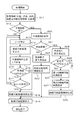
以上のように構成される表示装置100は、以下に説明する処理を行う。表示装置100において、操作部14の操作などによって航続可能範囲を表示するための機能が起動されると、処理ユニット10は、図4に示す手順に従って、以下に説明する処理を実行する。なお、処理ユニット10は、移動を伴う車両の航続可能範囲を適切に表示すべく、以下の処理を適切なタイミングで実行(例えば、計時機能を利用して定期的に実行)する。ここで、処理ユニット10による処理は、ハードウェアで行ってもよいし、プログラムを用いたソフトウェアで実現してもよい。
The
まず、処理ユニット10は、後述する処理に用いる各種情報を取得する(S11)。具体的には、処理ユニット10は、受信部11を制御して車両の現在位置を表す位置情報及び車両周囲の渋滞状況を表す渋滞情報を取得し、記憶部12を制御して地図情報を取得するとともに、車両情報管理装置200に情報提供を要求して残量情報及び燃費情報等を取得する。
First, the
次に、処理ユニット10は、記憶部12を制御して、記憶部12に予測情報が記憶されているか否かを判定する(S12)。なお、初回の処理の場合には予測情報は記憶されていないためNO判定となる。2回目以降の処理の場合にはYES判定となる。ステップS12にて予測情報が記憶されていない(NO)と判定された場合には、処理ユニット10は、地図情報の道路ネットワークから車両の現在位置を起点とする経路を抽出し、抽出した経路の末端のノードを特定する(S13)。
Next, the
次に、処理ユニット10は、残量情報及び燃費情報等を用いて車両の航続可能距離を算出する(S14)。なお、この際、道路勾配、乗車人数、天候等の航続距離に影響を及ぼす項目を考慮して航続可能距離を求めてもよい。このように各項目に応じて航続可能距離を調整することで、各項目に合わせて正確な航続可能距離を算出することができる。そして、処理ユニット10は、算出した航続可能距離及び道路情報等を用いて、特定したノードでの予測燃料残量を算出し、算出した予測燃料残量を特定したノードと関連づけて前述した予測情報を生成し、記憶部12に記憶する(S15)。この際、処理ユニット10は、渋滞情報により抽出経路の渋滞状況を判定し、渋滞中であると判定された場合には渋滞レベルに応じて渋滞消費量を設定し、特定したノードとその渋滞消費量とを関連づけて予測情報を生成する。
Next, the
ここで、先ほどの図2を用いて経路の抽出手順の一例について説明する。経路の抽出は、道路ネットワーク上の現在位置を始点にリンクL1を辿り、ノードN1にてその時点での予測燃料残量及び渋滞消費量を記憶しておき、その時点の予測航続余力値が所定値(本実施形態では、10%)以上であればノードN1に繋がる各リンク(リンクL2,L3,L4)へと抽出対象を延ばしていき、その先のノード(ノードN2,N3,N4)で同様の手順を繰り返すことで行われる。 Here, an example of a route extraction procedure will be described with reference to FIG. The route is extracted by tracing the link L1 starting from the current position on the road network, and storing the predicted remaining fuel amount and traffic consumption at that time in the node N1, and the predicted cruising surplus value at that time is predetermined. If the value (in this embodiment, 10%) or more, the extraction target is extended to each link (link L2, L3, L4) connected to the node N1, and the subsequent nodes (nodes N2, N3, N4) This is done by repeating the same procedure.
このように、経路の抽出は、抽出した道路リンクによる経路を車両が走行したものと考えた場合において予測航続余力値が所定値(10%)未満になるまで繰り返し行われる。したがって、予測航続余力値が所定値(10%)以上となる車両の航続可能経路は、現在位置を中心に放射状に網目のように広がるネットワーク状に形成される。なお、この所定値は、適宜設定されるものであり、0%であってもよいが、0%より大きい値とすることで、実際の車両の航続可能距離に余裕を持たせることができる。 Thus, the extraction of the route is repeated until the predicted cruising surplus value becomes less than a predetermined value (10%) when the vehicle is considered to have traveled the route by the extracted road link. Accordingly, the cruising possible route of the vehicle having the predicted cruising surplus value equal to or greater than the predetermined value (10%) is formed in a network shape that spreads radially like a mesh around the current position. The predetermined value is set as appropriate and may be 0%. However, by setting the predetermined value to a value larger than 0%, an actual cruising distance of the vehicle can be given a margin.
この航続可能経路の抽出を踏まえて、処理ユニット10は、図4に示すように、ステップS15での予測情報の記憶後、特定したノードの予測航続余力値が所定値(10%)以上であるか否かを判定する(S16)。予測航続余力値が所定値(10%)以上であると判定された場合(S16でYES)には、処理ユニット10は、航続可能経路となり得る全ノードを選択したか否かを判定し(S17)、全ノードを選択していない(NO)と判定された場合には、処理をステップS13に戻す。ステップS16にて予測航続余力値が所定値(10%)未満である(NO)と判定された場合及びステップS17にて全ノードを選択した(YES)と判定された場合には、処理ユニット10は、各ノードの予測航続余力値に基づき設定される航続可能範囲を表す航続可能範囲情報を生成する(S18)。具体的には、処理ユニット10は、図5に示すように、予測航続余力値が所定値(10%)であるノード(N5,N7,N6,...)を一筆書きにて繋いで形成される形成領域を航続可能範囲として設定する。
Based on the extraction of the cruising route, the
ところで、図4に示すように、ステップS12で予測情報がある(YES)と判定された場合には、処理ユニット10は、記憶部12から予測情報を読み出し取得することで、前回処理における各ノードの予測航続余力値を取得(算出)し(S20)、次いで、前回処理の時点(本実施形態に係る過去の時点)から現在の時点までに車両が移動したか否かを判定する(S21)。車両が移動していないと判定された場合(S21でNO)には、処理ユニット10は、前回処理の時点及び現在の時点での実測値である燃料残量値(実燃料残量)を用いて航続余力の変化率を算出する(S22)。例えば、車両がガソリン車であり、前回の燃料残量値が満タン10リットル(100%)であったのに対して今回の燃料残量値が9リットルであった場合には、航続余力の変化率は、「−10%」となる。つまり、アイドリング状態により燃料を10%消費したことになる。そして、処理ユニット10は、算出した変化率を用いて、現在の時点での航続可能範囲を表す航続可能範囲情報を生成する(S23)。例えば、前回処理の際に、図5に示す航続可能経路によって航続可能範囲が設定されていた場合であって、航続余力の変化率が「−10%」であった場合には、図6に示すように、各ノードの予測航続余力値がそれぞれ10%だけ差し引かれ、現在の時点での予測航続余力値がそれぞれ算出される。そして、算出された予測航続余力値が所定値(10%)であるノード(N2,N4,N3,...)を繋いで新たに形成された形成領域を現在の時点での航続可能範囲として設定し、その航続可能範囲を表す航続可能範囲情報が生成される。
By the way, as shown in FIG. 4, when it is determined in step S12 that there is prediction information (YES), the
一方、図4に示すように、ステップS21にて車両が移動した(YES)と判定された場合には、処理ユニット10は、所定のノード(例えば、車両の現在位置に最も近いノード)を選択し、選択したノードの前回処理の時点及び現在の時点での予測航続余力値を用いて航続余力の変化率を算出する(S24)。例えば、前回処理の時点での予測燃料残量が30%であるのに対して現在の時点での予測燃料残量が25%であった場合には、燃料残量の変化率は、「−5%」となる。
On the other hand, as shown in FIG. 4, when it is determined in step S21 that the vehicle has moved (YES), the
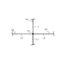
次に、処理ユニット10は、算出した変化率が閾値(本実施形態では、±10%)以上であるか否かを判定し(S25)、閾値(±10%)以上である(YES)と判定された場合には、処理をステップS13に移し、新たな航続可能経路での予測航続余力値の算出を行う。これにより、変化率が閾値(10%)以上と大きい場合であっても適切に航続可能範囲を設定することができる。なお、ここではフローを省略するが、変化率がゼロに近い場合(例えば、±5%未満)には、航続可能範囲の変化が少ないとして、前回処理の時点での航続可能範囲をそのまま現在の時点での航続可能範囲としてもよい。これにより処理を大きく簡略化することができる。ステップS25において、算出した変化率が閾値(±10%)以上でない(NO)と判定された場合には、処理ユニット10は、図7に示すように、主に車両の前方領域となる車両の移動方向に対して所定角度(例えば、図示するように進行方向に対して±45°)の範囲内にある領域を第1の航続可能範囲として設定する(S26)とともに、主に車両の後方領域となる車両の移動方向に対して所定角度の範囲外にある領域を第2の航続可能範囲として設定する(S27)。
Next, the
ここで、第1の航続可能範囲は、前述したステップS23での処理と同様、変化率と前回処理の時点での予測航続余力値とを用いて設定される。具体的には、前述した所定角度の範囲内にあるノードについて、ステップS23での処理と同様の処理を行う。一方、第2の航続可能範囲は、前回処理での航続可能範囲を利用して、変化率に応じて該航続可能範囲を補正することで設定される。つまり、図7に示すように、前回処理での航続可能範囲の周縁部を構成する各端点Tを、航続余力の変化率に応じて補正する(現在の車両位置方向に向かって移動(内側へ縮小)させる)ことで形成される補正領域を第2の航続可能範囲とする。なお、前回処理での航続可能範囲は、予測情報を用いて求めることができる。そして、第1の航続可能範囲と第2の航続可能範囲とを合わせた航続可能範囲(第1の航続可能範囲及び第2の航続可能範囲)を表す航続可能範囲情報を生成する(S28)。 Here, the first cruising range is set using the rate of change and the predicted cruising surplus value at the time of the previous process, as in the process in step S23 described above. Specifically, processing similar to the processing in step S23 is performed for the nodes within the predetermined angle range described above. On the other hand, the second cruising range is set by correcting the cruising range according to the change rate using the cruising range in the previous process. That is, as shown in FIG. 7, each end point T constituting the peripheral portion of the cruising range in the previous process is corrected according to the rate of change of the cruising remaining power (moving toward the current vehicle position (inward). The correction area formed by reducing the image is set as the second cruising range. The cruising range in the previous process can be obtained using the prediction information. Then, the cruising range information representing the cruising range (the first cruising range and the second cruising range) obtained by combining the first cruising range and the second cruising range is generated (S28).
ステップS18,S23,S28での航続可能範囲情報の生成後、処理ユニット10は、表示部13を制御して、生成した航続可能範囲情報に基づいて、図8に例示するような航続可能範囲を示す画像を表示部13に表示させて(S19)、処理を終了する。なお、図8中、最も細い線(細線)は、航続可能経路ではない道路を示し、それよりも太い線は、航続可能経路であることを示している。航続可能範囲であるか否かの境界(二点鎖線)や航続可能経路であるか否かの表示分けは、線の太さなどの線種ではなく、色の違いによって行ってもよいし、線種と色の違いの両方で行ってもよい。また、予測航続余力値に応じて更に詳細に表示分け(例えば、色分け)をしてもよい。これにより、利用者は、燃料消費と航続可能距離との関係を容易に把握することができる。
After generating the cruising range information in steps S18, S23, and S28, the
上述したような表示装置100によれば、現在の時点での各ノードの予測航続余力値を最初から新たに求めずとも、過去の時点(前回処理の時点)での予測航続余力値を利用して求めることができる。つまり、航続可能範囲を求めるに際し、新たに最初から全て求める場合と比較して処理を簡略化することができ、航続可能範囲を求める処理の負荷を低減させることができる。
According to the
また、航続可能範囲を設定するに際し、予測航続余力値が所定値(10%)以上となるノードに基づいて形成される形成領域が航続可能範囲となるので、航続可能範囲に余裕を持たせることができる。 Further, when setting the cruising range, the formation range formed based on the node whose predicted cruising surplus value is equal to or greater than the predetermined value (10%) becomes the cruising range, so that the cruising range should have a margin. Can do.
更に、ステップS21にて車両が移動していない(NO)と判定された場合には、実測値である燃料残量値のみの変化により求まる変化率が航続余力の変化率とされるので、航続余力の変化率を単純且つ容易に求めることができ、処理の負荷を更に低減させることができる。 Further, if it is determined in step S21 that the vehicle has not moved (NO), the rate of change obtained by the change in only the fuel remaining value, which is the actual measurement value, is set as the rate of change in the cruising reserve power. The rate of change of remaining power can be determined simply and easily, and the processing load can be further reduced.
また、ステップS21にて車両が移動している(YES)と判定された場合には、現在の時点での予測航続余力値を用いて第1の航続可能範囲が設定されるとともに、車両の移動方向に対して所定角度の範囲外に対応する過去の時点での航続可能範囲の周縁部を航続余力の変化率に応じて補正した補正領域が第2の航続可能範囲として設定され、第1の航続可能範囲及び第2の航続可能範囲を表す航続可能範囲情報が生成されるので、第2の航続可能範囲を単純且つ容易に求めることができ、処理の負荷を更に低減させることができる。 If it is determined in step S21 that the vehicle is moving (YES), the first cruising range is set using the predicted cruising surplus value at the current time, and the vehicle is moved. A correction region obtained by correcting the peripheral portion of the cruising range at a past time corresponding to outside the range of the predetermined angle with respect to the direction according to the rate of change of the cruising remaining power is set as the second cruising range, Since the cruising range information indicating the cruising range and the second cruising range is generated, the second cruising range can be obtained simply and easily, and the processing load can be further reduced.
本発明は、前述した実施の形態に限定されるものではなく、種々の変形が可能である。例えば、前述した実施形態中の数値、単位等は一例であり、これらは適宜設定することができる。 The present invention is not limited to the embodiments described above, and various modifications can be made. For example, the numerical values, units, and the like in the above-described embodiments are examples, and these can be set as appropriate.
以上のように、本発明に係る航続可能範囲表示装置、航続可能範囲表示方法及びプログラムは、航続可能範囲を求めるに際し、従来の場合と比較して処理を簡略化することができるので、車両の航続可能範囲を求める際の処理の負荷を低減させることができるという効果を有し、車両の航続可能範囲を表示する航続可能範囲表示装置、航続可能範囲表示方法及びプログラムとして有用である。 As described above, the cruising range display device, the cruising range display method, and the program according to the present invention can simplify the processing when determining the cruising range as compared with the conventional case, so that This has the effect of reducing the processing load when determining the cruising range, and is useful as a cruising range display device, a cruising range display method, and a program for displaying the cruising range of the vehicle.
10 処理ユニット
11 受信部
12 記憶部
13 表示部
14 操作部
100 航続可能範囲表示装置
200 車両情報管理装置
DESCRIPTION OF
Claims (6)
道路ネットワークを構成する複数のノードと前記複数のノードの各々についての過去の時点での予測航続余力値とが関連づけられた予測情報を記憶する記憶手段と、
前記記憶手段から前記予測情報を読み出して前記過去の時点での予測航続余力値を取得し、前記過去の時点から現在の時点までの航続余力の変化率を算出し、算出した前記航続余力の変化率と前記過去の時点での予測航続余力値とを用いて前記ノードの前記現在の時点での予測航続余力値を算出し、算出した前記現在の時点での予測航続余力値を用いて前記現在の時点での航続可能範囲を表す航続可能範囲情報を生成する情報処理手段と、
前記情報処理手段により生成された前記航続可能範囲情報に基づき前記現在の時点での航続可能範囲を表示する表示手段とを備える航続可能範囲表示装置。 A cruising range display device for displaying a cruising range of a vehicle,
Storage means for storing prediction information in which a plurality of nodes constituting a road network and predicted cruising surplus values at past times for each of the plurality of nodes are associated;
Reading the prediction information from the storage means to obtain a predicted cruising surplus power value at the past time point, calculating a rate of change of cruising surplus power from the past time point to the current time point, and calculating the change in the calculated cruising surplus power A predicted cruising surplus value at the current time of the node using the rate and a predicted cruising surplus value at the past time, and using the calculated predicted cruising surplus value at the current time Information processing means for generating cruising range information representing the cruising range at the time of
A cruising range display device comprising: display means for displaying the cruising range at the current time point based on the cruising range information generated by the information processing means.
前記情報処理手段は、前記過去の時点から前記現在の時点までに前記車両が移動しているか否かを判定し、移動していると判定された場合には、前記現在の時点での予測航続余力値を用いて前記第1の航続可能範囲を設定するとともに、前記所定角度の範囲外に対応する前記過去の時点での航続可能範囲の周縁部を前記航続余力の変化率に応じて補正した補正領域を前記第2の航続可能範囲として設定し、前記第1の航続可能範囲及び前記第2の航続可能範囲を表す航続可能範囲情報を生成する請求項1又は2に記載の航続可能範囲表示装置。 The cruising range has a first cruising range that is within a predetermined angle range with respect to the moving direction of the vehicle, and a second cruising range that is outside the predetermined angle range,
The information processing means determines whether or not the vehicle is moving from the past time point to the current time point. If it is determined that the vehicle is moving, the predicted continuation at the current time point is determined. The first cruising range is set using a surplus power value, and a peripheral portion of the cruising range at the past time point corresponding to outside the range of the predetermined angle is corrected according to a change rate of the cruising surplus power. The cruising range display according to claim 1 or 2, wherein a correction range is set as the second cruising range, and cruising range information representing the first cruising range and the second cruising range is generated. apparatus.
道路ネットワークを構成する複数のノードと前記複数のノードの各々についての過去の時点での予測航続余力値とが関連づけられた予測情報を取得し、前記過去の時点から現在の時点までの航続余力の変化率を算出し、算出した前記航続余力の変化率と前記過去の時点での予測航続余力値とを用いて前記ノードの前記現在の時点での予測航続余力値を算出し、算出した前記現在の時点での予測航続余力値を用いて前記現在の時点での航続可能範囲を表す航続可能範囲情報を生成する情報生成ステップと、
前記情報生成ステップにより生成された前記航続可能範囲情報に基づき前記現在の時点での航続可能範囲を表示する表示ステップとを備える航続可能範囲表示方法。 A cruising range display method for displaying a cruising range of a vehicle,
Obtaining prediction information in which a plurality of nodes constituting the road network and predicted cruising surplus values at each past time for each of the plurality of nodes are associated, and the cruising surplus power from the past time point to the current time point is acquired; Calculating the rate of change, calculating the predicted cruising reserve value at the current time of the node using the calculated rate of change of the cruising reserve and the predicted cruising reserve value at the past time point, and calculating the current An information generating step of generating cruising range information representing the cruising range at the current time point using the predicted cruising surplus value at the time point;
A cruising range display method comprising: a display step of displaying the cruising range at the current time point based on the cruising range information generated by the information generation step.
道路ネットワークを構成する複数のノードと前記複数のノードの各々についての過去の時点での予測航続余力値とが関連づけられた予測情報を取得し、前記過去の時点から現在の時点までの航続余力の変化率を算出し、算出した前記航続余力の変化率と前記過去の時点での予測航続余力値とを用いて前記ノードの前記現在の時点での予測航続余力値を算出し、算出した前記現在の時点での予測航続余力値を用いて前記現在の時点での航続可能範囲を表す航続可能範囲情報を生成する情報生成ステップと、
前記情報生成ステップにより生成された前記航続可能範囲情報に基づき前記現在の時点での航続可能範囲を表示手段に表示させる表示制御ステップとをコンピュータに実行させるプログラム。
A program that causes a computer to execute processing in a cruising range display device that displays a cruising range of a vehicle,
Obtaining prediction information in which a plurality of nodes constituting the road network and predicted cruising surplus values at each past time for each of the plurality of nodes are associated, and the cruising surplus power from the past time point to the current time point is acquired; Calculating the rate of change, calculating the predicted cruising reserve value at the current time of the node using the calculated rate of change of the cruising reserve and the predicted cruising reserve value at the past time point, and calculating the current An information generating step of generating cruising range information representing the cruising range at the current time point using the predicted cruising surplus value at the time point;
A program for causing a computer to execute a display control step of causing a display means to display a cruising range at the current time point based on the cruising range information generated by the information generation step.
Priority Applications (1)
| Application Number | Priority Date | Filing Date | Title |
|---|---|---|---|
| JP2016096730A JP6625482B2 (en) | 2016-05-13 | 2016-05-13 | Range display device, range display method and program |
Applications Claiming Priority (1)
| Application Number | Priority Date | Filing Date | Title |
|---|---|---|---|
| JP2016096730A JP6625482B2 (en) | 2016-05-13 | 2016-05-13 | Range display device, range display method and program |
Publications (2)
| Publication Number | Publication Date |
|---|---|
| JP2017203733A true JP2017203733A (en) | 2017-11-16 |
| JP6625482B2 JP6625482B2 (en) | 2019-12-25 |
Family
ID=60323277
Family Applications (1)
| Application Number | Title | Priority Date | Filing Date |
|---|---|---|---|
| JP2016096730A Active JP6625482B2 (en) | 2016-05-13 | 2016-05-13 | Range display device, range display method and program |
Country Status (1)
| Country | Link |
|---|---|
| JP (1) | JP6625482B2 (en) |
Cited By (5)
| Publication number | Priority date | Publication date | Assignee | Title |
|---|---|---|---|---|
| JP2021039064A (en) * | 2019-09-05 | 2021-03-11 | アイシン・エィ・ダブリュ株式会社 | Display device and computer program |
| CN112622619A (en) * | 2020-12-17 | 2021-04-09 | 江苏开沃汽车有限公司 | Display method of code-breaking screen instrument |
| US20220120582A1 (en) * | 2021-04-29 | 2022-04-21 | Beijing Baidu Netcom Science Technology Co., Ltd. | Route processing method and apparatus |
| CN114979221A (en) * | 2022-06-29 | 2022-08-30 | 阿波罗智能技术(北京)有限公司 | Vehicle signal processing method and device, electronic equipment and storage medium |
| JP2024057484A (en) * | 2022-10-12 | 2024-04-24 | トヨタ自動車株式会社 | Display device |
Citations (4)
| Publication number | Priority date | Publication date | Assignee | Title |
|---|---|---|---|---|
| JP2011075382A (en) * | 2009-09-30 | 2011-04-14 | Clarion Co Ltd | Navigation device and method for route calculation |
| JP2013015462A (en) * | 2011-07-05 | 2013-01-24 | Clarion Co Ltd | Navigation device |
| JP2014035215A (en) * | 2012-08-07 | 2014-02-24 | Sumitomo Electric System Solutions Co Ltd | Continuously drivable route arithmetic unit and computer program |
| JP2014115126A (en) * | 2012-12-07 | 2014-06-26 | Hitachi Ltd | Navigation system for electric vehicle |
-
2016
- 2016-05-13 JP JP2016096730A patent/JP6625482B2/en active Active
Patent Citations (4)
| Publication number | Priority date | Publication date | Assignee | Title |
|---|---|---|---|---|
| JP2011075382A (en) * | 2009-09-30 | 2011-04-14 | Clarion Co Ltd | Navigation device and method for route calculation |
| JP2013015462A (en) * | 2011-07-05 | 2013-01-24 | Clarion Co Ltd | Navigation device |
| JP2014035215A (en) * | 2012-08-07 | 2014-02-24 | Sumitomo Electric System Solutions Co Ltd | Continuously drivable route arithmetic unit and computer program |
| JP2014115126A (en) * | 2012-12-07 | 2014-06-26 | Hitachi Ltd | Navigation system for electric vehicle |
Cited By (9)
| Publication number | Priority date | Publication date | Assignee | Title |
|---|---|---|---|---|
| JP2021039064A (en) * | 2019-09-05 | 2021-03-11 | アイシン・エィ・ダブリュ株式会社 | Display device and computer program |
| JP7322608B2 (en) | 2019-09-05 | 2023-08-08 | 株式会社アイシン | Display device and computer program |
| CN112622619A (en) * | 2020-12-17 | 2021-04-09 | 江苏开沃汽车有限公司 | Display method of code-breaking screen instrument |
| US20220120582A1 (en) * | 2021-04-29 | 2022-04-21 | Beijing Baidu Netcom Science Technology Co., Ltd. | Route processing method and apparatus |
| US11788857B2 (en) * | 2021-04-29 | 2023-10-17 | Beijing Baidu Netcom Science Technology Co., Ltd. | Route processing method and apparatus |
| CN114979221A (en) * | 2022-06-29 | 2022-08-30 | 阿波罗智能技术(北京)有限公司 | Vehicle signal processing method and device, electronic equipment and storage medium |
| CN114979221B (en) * | 2022-06-29 | 2024-02-06 | 阿波罗智能技术(北京)有限公司 | Signal processing method and device for vehicle, electronic equipment and storage medium |
| JP2024057484A (en) * | 2022-10-12 | 2024-04-24 | トヨタ自動車株式会社 | Display device |
| JP7750203B2 (en) | 2022-10-12 | 2025-10-07 | トヨタ自動車株式会社 | display device |
Also Published As
| Publication number | Publication date |
|---|---|
| JP6625482B2 (en) | 2019-12-25 |
Similar Documents
| Publication | Publication Date | Title |
|---|---|---|
| US10890454B2 (en) | Integrating online navigation data with cached navigation data during active navigation | |
| US8635012B2 (en) | Optimization of travel routing | |
| US9360335B1 (en) | Dynamic rerouting during navigation | |
| JP5271637B2 (en) | Travel route evaluation system and travel route evaluation program | |
| TWI773880B (en) | Vehicle fuel consumption predicting method, vehicle navigation method and electronic device | |
| US20200065842A1 (en) | Method, apparatus, and computer program product for incentivizing travel along road segments | |
| JP2023535828A (en) | Routing method, device, equipment and medium | |
| JP6625482B2 (en) | Range display device, range display method and program | |
| US20160349075A1 (en) | Method and system of route scheduling and presenting route-based fuel information | |
| US20220187083A1 (en) | Generating navigation routes and identifying carpooling options in view of calculated trade-offs between parameters | |
| EP3505867B1 (en) | Method, apparatus, and computer program product for traffic optimized routing | |
| US20160076906A1 (en) | Navigation system with destination action mechanism and method of operation thereof | |
| US20250290769A1 (en) | Method, apparatus, and computer program product for facilitating selection of electric vehicle charge points | |
| JP2019105517A (en) | Navigation device, navigation system and image display method | |
| JP2015224871A (en) | Center device, driving support system, and driving support method | |
| US20230366694A1 (en) | Information processing method, information processing device, non-transitory computer-readable recording medium, and display device | |
| CN108332754B (en) | Path optimization method and device, electronic equipment and computer storage medium | |
| JP6685824B2 (en) | Cruising range display device, cruising range display method and program | |
| CN108763374B (en) | Driving path display method, device and equipment | |
| JP2015148528A (en) | Power consumption prediction device, navigation device using the same, and power consumption prediction method | |
| CN111951583A (en) | Prompt method and electronic device | |
| US20240370890A1 (en) | Demand prediction device, demand prediction method, and storage medium | |
| WO2024189902A1 (en) | Information processing device, information processing method, and information processing program | |
| JP2016173236A (en) | Route search device | |
| CN119459723A (en) | Vehicle dynamic driving endurance calculation method and device |
Legal Events
| Date | Code | Title | Description |
|---|---|---|---|
| A621 | Written request for application examination |
Free format text: JAPANESE INTERMEDIATE CODE: A621 Effective date: 20181225 |
|
| A977 | Report on retrieval |
Free format text: JAPANESE INTERMEDIATE CODE: A971007 Effective date: 20191106 |
|
| TRDD | Decision of grant or rejection written | ||
| A01 | Written decision to grant a patent or to grant a registration (utility model) |
Free format text: JAPANESE INTERMEDIATE CODE: A01 Effective date: 20191126 |
|
| A61 | First payment of annual fees (during grant procedure) |
Free format text: JAPANESE INTERMEDIATE CODE: A61 Effective date: 20191127 |
|
| R150 | Certificate of patent or registration of utility model |
Ref document number: 6625482 Country of ref document: JP Free format text: JAPANESE INTERMEDIATE CODE: R150 |