JP6878045B2 - 点群データの抽出方法、及び点群データの抽出装置 - Google Patents
点群データの抽出方法、及び点群データの抽出装置 Download PDFInfo
- Publication number
- JP6878045B2 JP6878045B2 JP2017037620A JP2017037620A JP6878045B2 JP 6878045 B2 JP6878045 B2 JP 6878045B2 JP 2017037620 A JP2017037620 A JP 2017037620A JP 2017037620 A JP2017037620 A JP 2017037620A JP 6878045 B2 JP6878045 B2 JP 6878045B2
- Authority
- JP
- Japan
- Prior art keywords
- point cloud
- cloud data
- locus
- point
- extraction
- Prior art date
- Legal status (The legal status is an assumption and is not a legal conclusion. Google has not performed a legal analysis and makes no representation as to the accuracy of the status listed.)
- Active
Links
Images


Classifications
-
- G—PHYSICS
- G01—MEASURING; TESTING
- G01B—MEASURING LENGTH, THICKNESS OR SIMILAR LINEAR DIMENSIONS; MEASURING ANGLES; MEASURING AREAS; MEASURING IRREGULARITIES OF SURFACES OR CONTOURS
- G01B21/00—Measuring arrangements or details thereof, where the measuring technique is not covered by the other groups of this subclass, unspecified or not relevant
- G01B21/30—Measuring arrangements or details thereof, where the measuring technique is not covered by the other groups of this subclass, unspecified or not relevant for measuring roughness or irregularity of surfaces
-
- G—PHYSICS
- G06—COMPUTING OR CALCULATING; COUNTING
- G06T—IMAGE DATA PROCESSING OR GENERATION, IN GENERAL
- G06T7/00—Image analysis
- G06T7/10—Segmentation; Edge detection
- G06T7/11—Region-based segmentation
-
- G—PHYSICS
- G01—MEASURING; TESTING
- G01B—MEASURING LENGTH, THICKNESS OR SIMILAR LINEAR DIMENSIONS; MEASURING ANGLES; MEASURING AREAS; MEASURING IRREGULARITIES OF SURFACES OR CONTOURS
- G01B11/00—Measuring arrangements characterised by the use of optical techniques
- G01B11/30—Measuring arrangements characterised by the use of optical techniques for measuring roughness or irregularity of surfaces
- G01B11/303—Measuring arrangements characterised by the use of optical techniques for measuring roughness or irregularity of surfaces using photoelectric detection means
-
- G—PHYSICS
- G01—MEASURING; TESTING
- G01B—MEASURING LENGTH, THICKNESS OR SIMILAR LINEAR DIMENSIONS; MEASURING ANGLES; MEASURING AREAS; MEASURING IRREGULARITIES OF SURFACES OR CONTOURS
- G01B21/00—Measuring arrangements or details thereof, where the measuring technique is not covered by the other groups of this subclass, unspecified or not relevant
-
- G—PHYSICS
- G01—MEASURING; TESTING
- G01C—MEASURING DISTANCES, LEVELS OR BEARINGS; SURVEYING; NAVIGATION; GYROSCOPIC INSTRUMENTS; PHOTOGRAMMETRY OR VIDEOGRAMMETRY
- G01C7/00—Tracing profiles
- G01C7/02—Tracing profiles of land surfaces
- G01C7/04—Tracing profiles of land surfaces involving a vehicle which moves along the profile to be traced
-
- G—PHYSICS
- G06—COMPUTING OR CALCULATING; COUNTING
- G06T—IMAGE DATA PROCESSING OR GENERATION, IN GENERAL
- G06T7/00—Image analysis
- G06T7/10—Segmentation; Edge detection
- G06T7/174—Segmentation; Edge detection involving the use of two or more images
-
- G—PHYSICS
- G06—COMPUTING OR CALCULATING; COUNTING
- G06T—IMAGE DATA PROCESSING OR GENERATION, IN GENERAL
- G06T2207/00—Indexing scheme for image analysis or image enhancement
- G06T2207/10—Image acquisition modality
- G06T2207/10016—Video; Image sequence
-
- G—PHYSICS
- G06—COMPUTING OR CALCULATING; COUNTING
- G06T—IMAGE DATA PROCESSING OR GENERATION, IN GENERAL
- G06T2207/00—Indexing scheme for image analysis or image enhancement
- G06T2207/10—Image acquisition modality
- G06T2207/10028—Range image; Depth image; 3D point clouds
-
- G—PHYSICS
- G06—COMPUTING OR CALCULATING; COUNTING
- G06T—IMAGE DATA PROCESSING OR GENERATION, IN GENERAL
- G06T2207/00—Indexing scheme for image analysis or image enhancement
- G06T2207/30—Subject of image; Context of image processing
- G06T2207/30248—Vehicle exterior or interior
- G06T2207/30252—Vehicle exterior; Vicinity of vehicle
- G06T2207/30256—Lane; Road marking
Landscapes
- Physics & Mathematics (AREA)
- General Physics & Mathematics (AREA)
- Engineering & Computer Science (AREA)
- Multimedia (AREA)
- Radar, Positioning & Navigation (AREA)
- Remote Sensing (AREA)
- Computer Vision & Pattern Recognition (AREA)
- Theoretical Computer Science (AREA)
- Length Measuring Devices With Unspecified Measuring Means (AREA)
- Length Measuring Devices By Optical Means (AREA)
Description
よって、測定経路について測定装置の全周にわたって取得された点群データから解析対象とする構造物についての解析対象点群データを簡単かつ自動的に抽出することができる。
また、所望の幅寸法での解析対象物についての点群データを迅速にかつ少ない漏れで抽出できる。
また、抽出領域には、複数の円柱領域と、複数の平行六面体領域の内部領域と、を含むので、本来なら道路の点群データとして、円柱領域から外れる点群データを平行六面体領域内部領域で抽出することができ、点群データの抽出漏れを最小限にすることができる。
よって、過度に多く軌跡点列を設定することがなくなり、流出領域の設定処理や点群データの抽出処理を簡単かつ迅速にできる。
よって、所望の幅寸法での路面についての点群データを迅速にかつ少ない漏れで抽出できる。
このため、点群データの抽出処理を、高性能な装置を使用することなく、簡単かつ高速に行うことができる。
110:データ格納部
120:軌跡点列設定部
130:抽出領域設定部
140:近似最近傍探索処理部
150:抽出処理部
160:道路点群データ出力部
200:路面評価装置
300:路面測定装置
310:スキャナ
320:全周カメラ
330:GNSS装置
340:車両
400:構造物
410:道路
420:建築物
500:画像
510:道路
520:建物
530:軌跡点列
540:画像
550:点群画像
Claims (5)
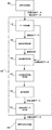
- 測定経路に沿って移動させつつ測定装置の周囲を走査して取得した全周点群データから特定の解析対象物についての点群データである対象点群データを抽出するべく、
前記測定経路における前記測定装置の移動の軌跡を複数の軌跡点として表した軌跡点列データを取得し、
前記軌跡点列データから取得した軌跡点列の各軌跡点のそれぞれを基準として位置が定まると共に、指定された幾何学形状で特定される領域を抽出領域として設定し、
前記全周点群データのうち前記抽出領域に属する点データを対象点群データとして抽出する、点群データの抽出方法であって、
前記抽出領域が前記軌跡点からの垂線上の予め定めた位置に、予め設定した径と予め設定した高さ寸法に設定された複数の円柱領域であり、
前記抽出領域には、
複数の前記円柱領域と、
隣り合う2個の前記円柱領域に着目したときにおける前記2個の円柱領域のそれぞれの外周面に外接する平行な2面の接平面、前記2個の円柱領域の上面に相当する上側平面、前記2個の円柱領域の底面に相当する底平面、前記2個の円柱領域のそれぞれにおいて前記2面の接平面が前記外周面と接する2本の母線を含み前記円柱領域の直径をなす2面の直径平面で囲まれた平行六面体領域の内部領域と、を含むことを特徴とする点群データの抽出方法。 - 前記軌跡点列は、予め定めた一定時間間隔で得られた測定軌跡点列データから指定した一定の距離だけ離間した軌跡点を取得することにより得られたことを特徴とする請求項1に記載の点群データの抽出方法。
- 前記測定経路が測定対象である道路での走行経路であり、
前記解析対象物が前記道路の路面であることを特徴とする請求項1に記載の点群データの抽出方法。 - 前記全周点群データが前記抽出領域に属しているか否かの判定を近似最近傍探索(ANN:Approximate Nearest Neighbor)および、指定された幾何学形状で特定される領域の内外判定を用いて行うことを特徴とする請求項1に記載の点群データの抽出方法。
- 測定経路に沿って移動させつつ測定装置の周囲を走査して取得した全周点群データから特定の解析対象物についての点群データである対象点群データを抽出するべく、
前記測定経路における前記測定装置の移動の軌跡を複数の軌跡点として表した軌跡点列を取得する手段と、
前記軌跡点のそれぞれを基準として位置が定まると共に、指定された幾何学形状で特定される領域を抽出領域として設定する手段と、
前記全周点群データのうち前記抽出領域に属する点データを対象点群データとして抽出する手段とを備える、点群データの抽出装置であって、
前記抽出領域が前記軌跡点からの垂線上の予め定めた位置に、予め設定した径と予め設定した高さ寸法に設定された複数の円柱領域であり、
前記抽出領域には、
複数の前記円柱領域と、
隣り合う2個の前記円柱領域に着目したときにおける前記2個の円柱領域のそれぞれの外周面に外接する平行な2面の接平面、前記2個の円柱領域の上面に相当する上側平面、前記2個の円柱領域の底面に相当する底平面、前記2個の円柱領域のそれぞれにおいて前記2面の接平面が前記外周面と接する2本の母線を含み前記円柱領域の直径をなす2面の直径平面で囲まれた平行六面体領域の内部領域と、を含むことを特徴とする点群データの抽出装置。
Priority Applications (4)
| Application Number | Priority Date | Filing Date | Title |
|---|---|---|---|
| JP2017037620A JP6878045B2 (ja) | 2017-02-28 | 2017-02-28 | 点群データの抽出方法、及び点群データの抽出装置 |
| EP18760902.9A EP3531068B1 (en) | 2017-02-28 | 2018-02-28 | Point cloud data extraction method and point cloud data extraction device |
| US16/461,160 US11204243B2 (en) | 2017-02-28 | 2018-02-28 | Point cloud data extraction method and point cloud data extraction device |
| PCT/JP2018/007545 WO2018159690A1 (ja) | 2017-02-28 | 2018-02-28 | 点群データの抽出方法、及び点群データの抽出装置 |
Applications Claiming Priority (1)
| Application Number | Priority Date | Filing Date | Title |
|---|---|---|---|
| JP2017037620A JP6878045B2 (ja) | 2017-02-28 | 2017-02-28 | 点群データの抽出方法、及び点群データの抽出装置 |
Publications (2)
| Publication Number | Publication Date |
|---|---|
| JP2018141757A JP2018141757A (ja) | 2018-09-13 |
| JP6878045B2 true JP6878045B2 (ja) | 2021-05-26 |
Family
ID=63370726
Family Applications (1)
| Application Number | Title | Priority Date | Filing Date |
|---|---|---|---|
| JP2017037620A Active JP6878045B2 (ja) | 2017-02-28 | 2017-02-28 | 点群データの抽出方法、及び点群データの抽出装置 |
Country Status (4)
| Country | Link |
|---|---|
| US (1) | US11204243B2 (ja) |
| EP (1) | EP3531068B1 (ja) |
| JP (1) | JP6878045B2 (ja) |
| WO (1) | WO2018159690A1 (ja) |
Families Citing this family (13)
| Publication number | Priority date | Publication date | Assignee | Title |
|---|---|---|---|---|
| AU2020229324B2 (en) * | 2019-02-25 | 2024-05-16 | Deka Products Limited Partnership | System and method for surface feature detection and traversal |
| JP7283005B2 (ja) | 2019-03-28 | 2023-05-30 | 株式会社トプコン | 点群データ処理方法および点群データ処理装置 |
| CN110118556A (zh) * | 2019-04-12 | 2019-08-13 | 浙江工业大学 | 一种基于协方差交叉融合slam的机器人定位方法及装置 |
| US11927457B2 (en) | 2019-07-10 | 2024-03-12 | Deka Products Limited Partnership | System and method for real time control of an autonomous device |
| CN111144211B (zh) * | 2019-08-28 | 2023-09-12 | 华为技术有限公司 | 点云显示方法和装置 |
| CN113536850B (zh) * | 2020-04-20 | 2022-09-30 | 长沙莫之比智能科技有限公司 | 基于77g毫米波雷达的目标物体大小测试方法和装置 |
| CN113759346B (zh) * | 2020-10-10 | 2024-06-18 | 北京京东乾石科技有限公司 | 一种激光雷达标定方法、装置、电子设备及存储介质 |
| CN112240772B (zh) * | 2020-12-16 | 2021-09-28 | 北京赛目科技有限公司 | 一种车道线生成方法及装置 |
| JP7538056B2 (ja) * | 2021-01-27 | 2024-08-21 | 三菱電機株式会社 | 点群削減装置及び点群削減プログラム |
| CN113870160B (zh) * | 2021-09-10 | 2024-02-27 | 北京交通大学 | 一种基于变换器神经网络的点云数据处理方法 |
| CN114387390B (zh) * | 2021-12-06 | 2025-05-02 | 中国铁路设计集团有限公司 | 接触网设施点云的全自动搜索和提取方法 |
| CN115794975B (zh) * | 2022-11-16 | 2025-12-19 | 武汉中海庭数据技术有限公司 | 高精度地图原始数据存储优化方法及系统 |
| JP7739345B2 (ja) * | 2023-01-30 | 2025-09-16 | 株式会社東芝 | プログラム、情報処理装置および情報処理方法 |
Family Cites Families (14)
| Publication number | Priority date | Publication date | Assignee | Title |
|---|---|---|---|---|
| JP3205799B2 (ja) * | 1991-11-13 | 2001-09-04 | 本田技研工業株式会社 | 移動体の現在位置表示装置 |
| EP0715150B1 (en) * | 1994-11-29 | 1999-09-01 | Xanavi Informatics Corporation | Navigation system with changeover if a radio signal cannot be received |
| JP3897191B2 (ja) | 1997-04-16 | 2007-03-22 | コマツエンジニアリング株式会社 | 平面の段差計測装置 |
| KR100959280B1 (ko) * | 2002-05-17 | 2010-05-26 | 오쿠마 가부시키가이샤 | Nc데이터의 공구궤적 표시방법 및 nc데이터 해석방법 |
| JP5852645B2 (ja) * | 2011-05-20 | 2016-02-03 | 株式会社日立製作所 | 軌跡補正方法、軌跡補正装置および移動体装置 |
| US8825391B1 (en) * | 2011-08-04 | 2014-09-02 | Google Inc. | Building elevation maps from laser data |
| WO2013129580A1 (ja) * | 2012-02-28 | 2013-09-06 | 公立大学法人大阪府立大学 | 近似最近傍探索装置、近似最近傍探索方法およびそのプログラム |
| JP2014032444A (ja) * | 2012-08-01 | 2014-02-20 | Asia Air Survey Co Ltd | 低解像度画像生成方法及び低解像度画像生成装置及びそのプログラム |
| JP5991489B2 (ja) * | 2013-02-21 | 2016-09-14 | 株式会社パスコ | 道路変状検出装置、道路変状検出方法及びプログラム |
| WO2016185659A1 (ja) * | 2015-05-15 | 2016-11-24 | 株式会社デンソー | 移動体位置検出装置、移動体位置検出方法 |
| JP6487283B2 (ja) * | 2015-06-19 | 2019-03-20 | 株式会社トヨタマップマスター | 点群データ処理装置、点群データ処理方法、プログラム、および記録媒体 |
| EP3404358B1 (en) * | 2016-03-07 | 2020-04-22 | Mitsubishi Electric Corporation | Map making device and map making method |
| CN108279670B (zh) * | 2017-12-29 | 2021-12-10 | 百度在线网络技术(北京)有限公司 | 用于调整点云数据采集轨迹的方法、设备以及计算机可读介质 |
| KR101996623B1 (ko) * | 2018-12-11 | 2019-07-04 | 주식회사 맵퍼스 | Gps 궤적 품질 지표를 이용한 고정밀 지도 데이터 구축 방법 및 시스템 |
-
2017
- 2017-02-28 JP JP2017037620A patent/JP6878045B2/ja active Active
-
2018
- 2018-02-28 EP EP18760902.9A patent/EP3531068B1/en active Active
- 2018-02-28 US US16/461,160 patent/US11204243B2/en not_active Expired - Fee Related
- 2018-02-28 WO PCT/JP2018/007545 patent/WO2018159690A1/ja not_active Ceased
Also Published As
| Publication number | Publication date |
|---|---|
| US11204243B2 (en) | 2021-12-21 |
| US20190285410A1 (en) | 2019-09-19 |
| EP3531068A4 (en) | 2020-04-01 |
| EP3531068A1 (en) | 2019-08-28 |
| JP2018141757A (ja) | 2018-09-13 |
| WO2018159690A1 (ja) | 2018-09-07 |
| EP3531068B1 (en) | 2021-09-22 |
Similar Documents
| Publication | Publication Date | Title |
|---|---|---|
| JP6878045B2 (ja) | 点群データの抽出方法、及び点群データの抽出装置 | |
| EP3621867B1 (en) | System and method for mapping a railway track | |
| JP5161936B2 (ja) | データ解析装置、データ解析方法、及びプログラム | |
| EP3401671B1 (en) | Detection device and detection method | |
| JP6125296B2 (ja) | データ解析装置、データ解析方法、及びプログラム | |
| JP6381100B2 (ja) | 3次元路面下診断システムおよび3次元路面下診断方法 | |
| JP6764842B2 (ja) | 情報処理装置、情報処理システム、情報処理方法、及び情報処理プログラム | |
| Atencio et al. | Calibration of UAV flight parameters for pavement pothole detection using orthogonal arrays | |
| Pérez et al. | Accuracy and effectiveness of orthophotos obtained from low cost UASs video imagery for traffic accident scenes documentation | |
| US20160133008A1 (en) | Crack data collection method and crack data collection program | |
| Ye et al. | Semi-automated generation of road transition lines using mobile laser scanning data | |
| JP2017015598A (ja) | 測量データ処理装置、測量データ処理方法および測量データ処理用プログラム | |
| US11247705B2 (en) | Train wheel measurement process, and associated system | |
| Chen et al. | Automated bridge deck evaluation through UAV derived point cloud | |
| CN110764106A (zh) | 一种采用激光雷达辅助盾构区间调坡调线测量施工方法 | |
| Rodríguez et al. | Laser scanning and its applications to damage detection and monitoring in masonry structures | |
| KR101323971B1 (ko) | 모바일 맵핑 시스템을 이용한 터널 정보 자동 취득 방법 | |
| JP5577312B2 (ja) | データ解析装置、データ解析方法、及びプログラム | |
| Razali et al. | A hybrid point cloud reality capture from terrestrial laser scanning and UAV-photogrammetry | |
| Suleymanoglu et al. | Road infrastructure mapping by using iPhone 14 Pro: An accuracy assessment | |
| WO2022152973A1 (en) | A method for identifying a road type | |
| JP6397386B2 (ja) | 領域分割処理装置、方法、及びプログラム | |
| JP7082227B1 (ja) | 路面性状調査システム、路面性状調査装置、及び路面性状調査方法 | |
| JP6516384B2 (ja) | 情報処理装置、情報処理システム、情報処理方法、及び情報処理プログラム | |
| JP7241948B2 (ja) | 路面性状調査システム、路面性状調査装置、及び路面性状調査方法 |
Legal Events
| Date | Code | Title | Description |
|---|---|---|---|
| A521 | Request for written amendment filed |
Free format text: JAPANESE INTERMEDIATE CODE: A821 Effective date: 20170301 |
|
| A621 | Written request for application examination |
Free format text: JAPANESE INTERMEDIATE CODE: A621 Effective date: 20200228 |
|
| A131 | Notification of reasons for refusal |
Free format text: JAPANESE INTERMEDIATE CODE: A131 Effective date: 20201002 |
|
| A601 | Written request for extension of time |
Free format text: JAPANESE INTERMEDIATE CODE: A601 Effective date: 20201026 |
|
| A521 | Request for written amendment filed |
Free format text: JAPANESE INTERMEDIATE CODE: A523 Effective date: 20210128 |
|
| TRDD | Decision of grant or rejection written | ||
| A01 | Written decision to grant a patent or to grant a registration (utility model) |
Free format text: JAPANESE INTERMEDIATE CODE: A01 Effective date: 20210402 |
|
| A61 | First payment of annual fees (during grant procedure) |
Free format text: JAPANESE INTERMEDIATE CODE: A61 Effective date: 20210428 |
|
| R150 | Certificate of patent or registration of utility model |
Ref document number: 6878045 Country of ref document: JP Free format text: JAPANESE INTERMEDIATE CODE: R150 |
|
| R250 | Receipt of annual fees |
Free format text: JAPANESE INTERMEDIATE CODE: R250 |
|
| R250 | Receipt of annual fees |
Free format text: JAPANESE INTERMEDIATE CODE: R250 |