KR101123737B1 - Method for extension of vehicle sensing range through communication, and system thereof - Google Patents
Method for extension of vehicle sensing range through communication, and system thereof Download PDFInfo
- Publication number
- KR101123737B1 KR101123737B1 KR1020100084936A KR20100084936A KR101123737B1 KR 101123737 B1 KR101123737 B1 KR 101123737B1 KR 1020100084936 A KR1020100084936 A KR 1020100084936A KR 20100084936 A KR20100084936 A KR 20100084936A KR 101123737 B1 KR101123737 B1 KR 101123737B1
- Authority
- KR
- South Korea
- Prior art keywords
- information
- moving object
- detection
- communication
- detection information
- Prior art date
- Legal status (The legal status is an assumption and is not a legal conclusion. Google has not performed a legal analysis and makes no representation as to the accuracy of the status listed.)
- Expired - Fee Related
Links
Images


Landscapes
- Engineering & Computer Science (AREA)
- Radar, Positioning & Navigation (AREA)
- Remote Sensing (AREA)
- Physics & Mathematics (AREA)
- General Physics & Mathematics (AREA)
- Traffic Control Systems (AREA)
- Computer Networks & Wireless Communication (AREA)
Abstract
본 발명은 이동체간 및 이동체-기지국간 통신을 이용해 기존의 단일 센서가 갖는 제한된 탐지거리라는 한계를 극복하여 사고 발생을 예방하고 보다 효율적인 트래픽 환경을 조성하는데 일조하기 위해, 한 이동체의 탐지 영역 내에 있는 다른 이동체와의 무선 통신을 통해 그 이동체의 탐지정보를 수신하고, 수신된 탐지정보를 기존 탐지 정보와 융합하여 원 센서의 탐지거리를 확장할 수 있도록 된, 통신을 이용한 이동체의 탐지거리 확장 방법 및 시스템에 관한 것이다.
본 발명에 따른 이동체의 탐지거리 확장 시스템은, 특정 영역 내의 트래픽 정보를 탐지하는 센싱부; 상기 탐지된 트래픽 정보를 처리하여 메타정보를 생성하는 전처리부; 외부로부터 전송되어 온 탐지 정보를 수신하는 수신부; 상기 메타정보와 상기 탐지 정보를 융합하여 최종 메타정보를 생성하는 센서융합 처리부; 및 상기 최종 메타정보를 출력하는 출력부를 포함한다.The present invention utilizes communication between mobile and mobile-base stations to overcome the limitations of the limited detection distance of a single sensor, to prevent accidents and to create a more efficient traffic environment. Receiving detection information of the moving object through wireless communication with another moving object, and the detection distance extension method of the mobile object using communication to expand the detection distance of the original sensor by fusing the received detection information with the existing detection information and It is about the system.
In accordance with an aspect of the present invention, there is provided a system for detecting a range of a moving object including: a sensing unit detecting traffic information in a specific area; A preprocessor configured to process the detected traffic information to generate meta information; Receiving unit for receiving the detection information transmitted from the outside; A sensor fusion processor configured to fuse the meta information and the detection information to generate final meta information; And an output unit for outputting the final meta information.
Description
본 발명은 이동체간(Vehicle-to-vehicle) 및 이동체와 기지국간(Vehicle-to- Infrastructure) 통신을 이용하여 한 이동체의 탐지 정보에, 주변의 다른 이동체의 탐지 정보를 합해서 이동체의 탐지영역을 확장하는 방법 및 시스템에 관한 것으로서, 보다 자세하게는 한 이동체의 탐지 영역 내에 있는 다른 이동체와의 무선 통신을 통해 그 이동체의 탐지정보를 수신하고, 수신된 탐지정보를 기존 탐지정보와 융합하여 원래의 탐지영역을 확장할 수 있도록 된 것이다.
The present invention expands the detection area of a moving object by adding detection information of one moving object to detection information of another moving object by using vehicle-to-vehicle and vehicle-to-infrastructure communication. In more detail, the present invention relates to a method and a system, and more particularly, to receive detection information of a moving object through wireless communication with another moving object within a detection area of one moving object, and to merge the received detection information with existing detection information to detect an original detection area. It is now possible to extend.
정보통신 기술의 발달은 차량, 선박, 항공기 등 이동체의 편의성과 안전성을 높이는데 크게 기여하고 있다. 일례로 차량의 경우 교통체증, 교통사고 등의 교통환경 악화에 대처하기 위하여 지능형 교통 시스템, 지능형 자동차의 필요성이 제기되었고, 최근에는 고급차량뿐만 아니라 보급형 양산 차량에서도 레이더, 비전, 초음파 센서가 점차 탑재되어 차량의 주행 안전성과 주행 편의성을 높이는데 크게 기여하고 있다. The development of information and communication technology has greatly contributed to improving the convenience and safety of mobile vehicles such as vehicles, ships and aircrafts. For example, in order to cope with the deterioration of traffic conditions such as traffic jams and accidents, the need for intelligent transportation systems and intelligent cars has been raised. Recently, radar, vision and ultrasonic sensors are gradually installed in high-end vehicles as well as low-end mass production vehicles. As a result, the vehicle has greatly contributed to improving driving safety and driving convenience.
특히 현재 차량에 가장 널리 보급되어 있는 대표적 센서인 밀리미터파 레이더의 경우, 송신파와 수신파 사이의 시간차와 도플러 주파수 편이를 이용하여 선행차량 또는 전방의 장애물과의 거리와 상대속도를 판별하는 장치로서 순항제어 시스템(active cruise control system) 등에 이용되는 핵심 기술이다. 순항제어 시스템이란 레이더 센서를 통하여 전방 선행 차량, 장애물의 속도 및 거리를 측정하여 차량의 충돌 경고, 주행 상황에 따른 자동적인 감속 및 가속, 정속 등 안전운행이 가능하도록 하는 기술이다. 또한 비전 센서는 차선 인식을 통한 차선유지 시스템(lane keeping assist system) 등에 이용되고 있다.In particular, in the case of millimeter wave radar, which is the most widely used sensor in the current vehicle, it is a device that discriminates the distance and relative speed from the preceding vehicle or obstacle in front by using the time difference between the transmitting wave and the receiving wave and the Doppler frequency shift. It is a key technology used in active cruise control systems. The cruise control system is a technology that measures the speed and distance of the preceding vehicle and obstacles through the radar sensor to enable safe driving such as collision warning, automatic deceleration and acceleration according to driving conditions, and constant speed. Vision sensors are also used in lane keeping assist systems.
이러한 각종 센서의 이용은 기존의 센서를 이용하지 않던 상황에 비해서는 분명히 트래픽 체증이나 사고에 대한 문제들을 개선해 주겠지만, 각 센서의 감지영역 내에서만 그 기능을 보장한다는 한계를 갖는다. The use of such various sensors will definitely improve the problems of traffic jams and accidents compared to the situation of not using the conventional sensors, but has a limitation in ensuring its function only in the detection area of each sensor.
일 예로, 정체구간까지 센서의 범위가 닿지 않는 이동체들의 경우, 센서가 그것을 인식하지 못하기 때문에 목적지를 향한 다른 길이 있더라도 정체구간을 향해 달려가게 되고, 이는 트래픽 체증을 더욱 심하게 만들며 이동체의 이동성을 악화시킬 수 있다. 또한 장애물 뒤에 보행자나 다른 이동체가 지나가고, 이동체의 센서가 장애물에 막혀 그 보행자나 다른 이동체를 인식하지 못한 경우 역시 큰 사고로 이어질 수 있다.
For example, in the case of moving objects that do not reach the range of the sensor until the congestion section, the sensor does not recognize it, so even if there is another way to the destination, it will run toward the congestion section, which makes traffic congestion worse and worsens the mobility of the moving object. You can. In addition, when a pedestrian or other moving object passes behind an obstacle, and a sensor of the moving object is blocked by an obstacle, the pedestrian or another moving object may not be recognized, which may lead to a big accident.
전술한 문제점을 해결하기 위한 본 발명은, 이동체간 및 이동체와 기지국간 통신을 이용해 기존의 단일 센서가 갖는 제한된 탐지영역이라는 한계를 극복하고 사고 발생과 트래픽 체증을 완화시킴으로써 보다 효율적인 트래픽 환경을 조성하는데 일조하기 위해, 한 이동체의 탐지 영역 내에 있는 다른 이동체와의 무선 통신을 통해 그 이동체의 탐지정보를 수신하고, 수신된 탐지정보를 기존 탐지정보와 융합하여 탐지영역을 확장할 수 있도록 된, 통신을 이용한 이동체의 탐지영역 확장 방법 및 시스템을 제공함에 그 목적이 있다.
The present invention to solve the above problems, by using the communication between the mobile and the mobile and the base station to overcome the limitation of the limited detection area of the existing single sensor and to create a more efficient traffic environment by mitigating the occurrence of accidents and traffic jams In order to assist, the communication information can be extended by receiving detection information of the moving object through wireless communication with another moving object within the detection area of one moving object and fusing the received detection information with the existing detection information. It is an object of the present invention to provide a method and a system for expanding a detection area of a moving object.
전술한 목적을 달성하기 위한 본 발명의 일 측면에 따르면, 특정 영역 내의 트래픽 정보를 탐지하는 센싱부; 상기 탐지된 트래픽 정보를 처리하여 메타정보를 생성하는 전처리부; 외부로부터 전송되어 온 탐지 정보를 수신하는 수신부; 상기 메타정보와 상기 탐지 정보를 융합하여 최종 메타정보를 생성하는 센서융합 처리부; 및 상기 최종 메타정보를 출력하는 출력부를 포함하는 이동체의 탐지거리 확장 시스템이 제공될 수 있다.According to an aspect of the present invention for achieving the above object, a sensing unit for detecting traffic information in a specific area; A preprocessor configured to process the detected traffic information to generate meta information; Receiving unit for receiving the detection information transmitted from the outside; A sensor fusion processor configured to fuse the meta information and the detection information to generate final meta information; And an output unit for outputting the final meta-information.
또한, 상기 최종 메타정보를 외부로 송출하기 위한 송신부를 더 포함할 수 있다.The apparatus may further include a transmitter for transmitting the final meta information to the outside.
또한, 상기 센싱부는, 이동체 전면의 서로 다른 위치에 한개 이상의 센서를 구비하고, 이동체의 인근에 다른 이동체가 있더라도 상기 한개 이상의 센서를 통해 상기 다른 이동체 너머의 영역까지 트래픽 정보를 탐지할 수 있다.In addition, the sensing unit may include one or more sensors at different locations on the front of the moving object, and may detect traffic information beyond the other moving object through the one or more sensors even if there are other moving objects in the vicinity of the moving object.
또한, 상기 전처리부는 GPS 위성으로부터 위치 정보를 수신하여 이동체의 절대적 위치 정보를 획득하는 GPS 모듈을 포함할 수 있다.In addition, the preprocessor may include a GPS module for receiving the position information from the GPS satellites to obtain the absolute position information of the moving object.
또한, 상기 전처리부는, 상기 센싱부로부터 탐지된 트래픽 정보들 중, 이동체의 직접적인 트래픽 정보 외의 다른 정보들을 걸러내어 트래픽 정보의 용량을 최소화하고, 이렇게 얻어진 트래픽 정보를 바탕으로 탐지된 이동체들의 속도 및 방향을 측정하며, 탐지된 이동체들에 특정 ID를 부여하는 마이크로 프로세서를 포함할 수 있다.In addition, the pre-processing unit, by filtering other information other than the direct traffic information of the moving object of the traffic information detected from the sensing unit to minimize the capacity of the traffic information, the speed and direction of the detected mobile objects based on the traffic information thus obtained It may include a microprocessor to measure the, and to give a specific ID to the detected moving objects.
또한, 상기 센서융합 처리부는, 상기 전처리부에서 생성된 상기 메타정보와, 타 이동체로부터 수신된 상기 탐지 정보를 현재 위치를 기준으로 결합해 상기 최종 메타정보를 생성할 수 있다.The sensor fusion processor may generate the final meta information by combining the meta information generated by the preprocessor and the detection information received from another moving object based on a current position.
또한, 상기 메타정보는 전방 이동체의 속도, 방향, 거리 정보 등을 포함할 수 있다.In addition, the meta information may include speed, direction, distance information of the front moving object.
또한, 상기 센서융합 처리부는, 타 이동체로부터 수신된 상기 탐지 정보를 상기 메타정보에 포함된 전방 이동체와의 거리, 방향 차이를 반영하여 현 이동체의 위치와 방향을 기준으로 수정하여 상기 최종 메타정보를 생성할 수 있다.The sensor fusion processor may be further configured to correct the detection information received from another moving object based on the position and direction of the current moving object by reflecting a distance and a direction difference from the front moving object included in the meta information. Can be generated.
또한, 상기 센서융합 처리부는, 상기 메타 정보와 상기 탐지 정보의 융합 시에 중복된 데이터가 발생될 경우에, 상기 수신된 탐지정보를 송신한 이동체가 현 이동체의 탐지영역 바깥이 아닌 내부에 있는지 여부를 먼저 판단하고, 탐지영역 내부에 이동체가 있을 경우 현 이동체의 센서에 탐지된 특정 이동체의 좌표와, 현 위치를 기준으로 수정된 타 이동체의 탐지정보에 포함된 특정 이동체의 좌표차가 특정 임계값 이하라면 동일한 이동체로 처리할 수 있다.In addition, the sensor fusion processing unit, if duplicate data is generated during the fusion of the meta information and the detection information, whether or not the moving object transmitting the received detection information is not inside the detection area of the current moving object; First, if there is a moving object in the detection area, the coordinate difference of the specific moving object detected by the sensor of the current moving object and the coordinate of the specific moving object included in the detection information of the other moving object modified based on the current position is below a certain threshold value. If it can be treated with the same moving body.
그리고, 상기 최종 메타정보에 근거한 탐지 확장 영역을 확인하거나 제한할 수 있는 명령을 입력받기 위한 입력부를 더 포함할 수 있다.
The apparatus may further include an input unit for receiving a command for checking or limiting the detection extension region based on the final meta information.
한편, 전술한 목적을 달성하기 위한 본 발명의 다른 측면에 따르면, (a) 특정 영역 내의 트래픽 정보를 탐지하는 단계; (b) 상기 탐지된 트래픽 정보를 처리하여 메타정보를 생성하는 단계; (c) 상기 트래픽 정보에 근거해 탐지정보를 요청할 통신 대상을 결정하는 단계; (d) 상기 통신 대상에 요청하여, 상기 통신 대상으로부터 탐지정보를 수신하는 단계; (e) 상기 메타정보와 상기 탐지정보를 융합하여 최종 메타정보를 생성하는 단계; 및 (f) 상기 최종 메타정보를 출력하는 단계를 포함하는 이동체의 탐지영역 확장 방법이 제공될 수 있다.On the other hand, according to another aspect of the present invention for achieving the above object, (a) detecting traffic information in a specific area; (b) processing the detected traffic information to generate meta information; (c) determining a communication target for requesting detection information based on the traffic information; (d) requesting the communication object to receive detection information from the communication object; (e) fusing the meta information and the detection information to generate final meta information; And (f) outputting the final meta-information.
또한, 상기 (e) 단계는, 상기 수신된 탐지정보에서 이동체의 직접적인 정보 외의 다른 정보들을 걸러내어 데이터의 용량을 최소화하여 얻은 데이터를 바탕으로, 수신된 탐지정보의 좌표계를 수신이동체의 좌표계로 변환하고, 중복 영역을 제거하고, 수신된 탐지된 이동체들의 속도 및 방향을 측정하며, 탐지된 이동체들에 특정 ID를 부여할 수 있다.In addition, the step (e) converts the coordinate system of the received detection information into the coordinate system of the receiving vehicle based on the data obtained by filtering out other information other than the direct information of the moving object from the received detection information to minimize the data capacity. Remove the redundant area, measure the speed and direction of the received detected moving objects, and assign specific IDs to the detected moving objects.
또한, 상기 (e) 단계는, 상기 수신된 탐지정보에 근거해 탐지된 이동체들의 방향을 측정할 때, 짧은 시간 간격으로 전방 이동체를 탐지하여 그 궤적을 벡터로 나타내어 현 이동체와의 방향 차이를 분석할 수 있다.Also, in the step (e), when measuring the direction of the detected moving objects based on the received detection information, the front moving object is detected at a short time interval and the trajectory is represented as a vector to analyze the direction difference with the current moving object. can do.
또한, 상기 (c) 단계는, 상기 트래픽 정보에 근거해 탐지정보를 요청할 통신 대상을 선택할 때, 전방의 모든 이동체들에게 통신 요청을 하지 않고, 현 이동체에 탐지된 타 이동체들의 위치, 방향, 센서의 탐지 가능 영역에 근거하여, 현 이동체로부터 가장 멀리 떨어져 있고, 서로의 탐지 영역이 가장 겹치지 않는 이동체들을 통신 대상으로 결정할 수 있다.In addition, in the step (c), when selecting a communication target for requesting detection information based on the traffic information, the location, direction, and sensor of the other moving objects detected in the current moving object are not requested to all the moving objects in front. Based on the detectable area of, the mobile objects that are farthest from the current moving object and that do not overlap the detection areas of each other can be determined as communication targets.
또한, 상기 (c) 단계는 상기 통신 대상을 결정할 때, GPS 정보와 상기 탐지정보에 근거하여, 전방 이동체의 절대적 위치(위도/경도)를 파악하고, 상기 절대적 위치(위도/경도)를 ID로 사용하여 상기 통신 대상을 결정하며, 상기 (d) 단계는 상기 통신 대상에 상기 탐지정보를 요청하여 상기 통신 대상으로부터 상기 탐지정보를 수신할 때, 각 이동체들이 이동하고 있으므로 위치가 변한다는 점을 고려하여, 상기 ID의 절대적 위치에서 상기 이동체의 이동에 따라 변한 위치와의 거리 차가 특정 임계값 이하이면 수신된 탐지 정보가 통신대상이었던 해당 이동체로부터 송신된 것으로 인식할 수 있다.In the step (c), when determining the communication target, the absolute position (latitude / longitude) of the front moving object is determined based on the GPS information and the detection information, and the absolute position (latitude / longitude) is determined as an ID. And determining the communication target, and the step (d) takes into account that the position changes because each moving object is moving when requesting the detection information from the communication target and receiving the detection information from the communication target. Thus, when the distance difference between the position changed according to the movement of the moving object from the absolute position of the ID is less than or equal to a certain threshold, it may be recognized that the received detection information is transmitted from the corresponding moving object which was the communication target.
또한, 상기 (c) 단계는 상기 통신 대상을 결정할 때, 전방 이동체의 속도 정보를 ID로 사용하여 상기 통신 대상을 결정할 수 있다.Further, in the step (c), when determining the communication target, the communication target may be determined using the speed information of the front moving object as an ID.
또한, 상기 (e) 단계는, 상기 메타정보와 상기 탐지정보를 융합할 때, 타 이동체로부터 수신된 탐지정보를, 현 이동체의 메타정보에 포함된 전방 이동체와의 거리, 방향 차이를 반영하여 현 이동체의 위치와 방향을 기준으로 수정하여 상기 최종 메타정보를 생성할 수 있다.Also, in the step (e), when the meta information and the detection information are fused, the detection information received from another moving object may be reflected by a difference in distance and direction from the front moving object included in the meta information of the current moving object. The final meta information may be generated by modifying the position and the direction of the moving object.
또한, 상기 (e) 단계는 전방 이동체의 속도, 방향, 거리 정보를 포함하는 상기 메타정보와 타 이동체로부터 수신된 타 이동체의 상기 탐지정보를 현 위치를 기준으로 융합하여 상기 최종 메타정보를 생성할 수 있다.The step (e) may generate the final meta information by fusing the meta information including the speed, direction, and distance information of the front moving object with the detection information of another moving object received from another moving object based on the current position. Can be.
그리고, 상기 (e) 단계는 상기 메타정보와 상기 탐지정보의 융합 시, 중복되는 정보를 처리할 때, 상기 탐지정보를 송신한 이동체가 현 이동체의 탐지 영역 가장자리가 아닌 내부에 있는지 여부를 먼저 판단하고, 탐지 영역 내부에 이동체가 있을 경우 현 이동체의 센서에 탐지된 특정 이동체의 좌표와, 현 위치를 기준으로 수정된 타 이동체의 탐지정보에 포함된 특정 이동체의 좌표차가 특정 임계값 이하이면 동일한 이동체로 간주하여 처리할 수 있다.
In the step (e), when processing the overlapping information when the meta information and the detection information are fused, it is first determined whether the moving object that transmits the detection information is not inside the detection area of the current moving object. If there is a moving object inside the detection area, if the coordinate of the specific moving object detected by the sensor of the current moving object and the coordinate difference of the specific moving object included in the detection information of the other moving object modified on the basis of the current position are equal to or less than a certain threshold, the same moving object Can be regarded as.
본 발명에 의하면, 각 이동체의 단일 센서가 갖는 탐지 영역의 한계를 넘어 보다 넓은 탐지 영역을 확보할 수 있다. 이를 통해 더욱 극심해질 수 있는 트래픽 체증을 사전에 예방할 수 있고, 단순 레이더나 비전 센서 등 만으로는 확보되지 않는 사각 영역에 대한 시야를 확보하게 됨으로써 발생 가능한 사고를 줄일 수 있다. According to the present invention, a wider detection area can be secured beyond the detection area limit of a single sensor of each moving object. This can prevent traffic jams that can be more severe in advance and reduce the possibility of accidents by securing visibility into blind spots that cannot be secured by simple radar or vision sensors.
또한, 트래픽 정보에 대한 접근성이 제한적이었던 종래와 달리, 통신 가능한 이동체만 있다면 언제든지 원하는 정보를 얻을 수 있는 실시간 트래픽 정보 이용 환경을 구현할 수 있다.In addition, unlike the related art, in which access to traffic information is limited, a real-time traffic information using environment may be implemented at any time as long as there is a communicable mobile object.
그리고, 이동체 스스로가 송신체 및 수신체가 됨으로써 트래픽 정보를 얻기에 비싼 초기 설치비용을 절약할 수 있다.
In addition, since the mobile body itself becomes a transmitter and a receiver, it is possible to save an initial installation cost that is expensive to obtain traffic information.
도 1은 본 발명의 실시예에 따른 이동체의 탐지영역 확장 시스템을 개략적으로 나타낸 블럭 구성도이다.
도 2는 본 발명의 실시예에 따른 센싱부와 전처리부를 나타낸 도면이다.
도 3은 본 발명의 실시예에 따른 전처리부의 동작 과정을 나타낸 흐름도이다.
도 4는 본 발명의 실시예에 따라 통신 대상 이동체들에 대해 고유 식별자를 부여한 예를 나타낸 도면이다.
도 5는 본 발명의 실시예에 따른 센서융합 처리부의 동작 과정을 나타낸 흐름도이다.
도 6은 본 발명의 실시예에 따른 이동체의 탐지영역 확장 방법을 설명하기 위한 동작 흐름도이다.
도 7은 본 발명의 실시예에 따라 중첩된 영역에 존재한 이동체들을 기준으로 앞 이동체가 어느 방향을 향하는지 추정해 내는 예를 나타낸 도면이다.
도 8은 본 발명의 실시예에 따라 통신 대상 이동체로부터 수신된 정보가 현 위치로부터 어느 정도 떨어진 곳에서 어떤 방향을 바라보고 탐지된 정보인지를 반영해 탐지 정보를 융합시키는 예를 나타낸 도면이다.1 is a block diagram schematically illustrating a system for expanding a detection area of a moving object according to an exemplary embodiment of the present invention.
2 is a view showing a sensing unit and a preprocessor according to an embodiment of the present invention.
3 is a flowchart illustrating an operation process of a preprocessor according to an embodiment of the present invention.
4 is a diagram illustrating an example of assigning unique identifiers to communication targets according to an embodiment of the present invention.
5 is a flowchart illustrating an operation process of a sensor fusion processor according to an exemplary embodiment of the present invention.
6 is a flowchart illustrating a method of expanding a detection area of a moving object according to an exemplary embodiment of the present invention.
FIG. 7 is a diagram illustrating an example of estimating which direction the front moving body faces based on moving objects existing in the overlapped area according to an exemplary embodiment of the present invention.
FIG. 8 is a diagram illustrating an example of integrating detection information by reflecting in which direction the information received from the communication target mobile object is detected and looking in a direction away from the current position according to an embodiment of the present invention.
본 발명의 목적과 기술적 구성 및 그에 따른 작용 효과에 관한 자세한 사항은 본 발명의 명세서에 첨부된 도면에 의거한 이하 상세한 설명에 의해 보다 명확하게 이해될 것이다. 이하, 첨부된 도면을 참조하여 본 발명에 따른 실시예를 상세하게 설명한다.DETAILED DESCRIPTION OF THE PREFERRED EMBODIMENTS Reference will now be made in detail to the preferred embodiments of the present invention, examples of which are illustrated in the accompanying drawings, wherein like reference numerals refer to the like elements throughout. Hereinafter, exemplary embodiments of the present invention will be described in detail with reference to the accompanying drawings.
이동체의 탐지 영역을 확장하는 방법은 센서 자체의 기능을 개선하는 방법, 지형?도로 정보뿐만 아니라 트래픽 양까지 파악해주는 GPS 시스템의 개발 및 이동체에의 탑재, 이동체간 통신 등 여러 가지가 있으나, 본 발명에서는 센서를 탑재한 이동체간, 그리고 이동체와 기지국간 통신을 이용한다.There are various methods of extending the detection area of a mobile body, such as a method of improving the function of the sensor itself, development of a GPS system that detects traffic volume as well as terrain and road information, mounting on a mobile body, and communication between mobile bodies. Uses communication between mobile devices equipped with sensors and mobile and base stations.
도 1은 본 발명의 실시예에 따른 이동체의 탐지영역 확장 시스템을 개략적으로 나타낸 블럭 구성도이다.1 is a block diagram schematically illustrating a system for expanding a detection area of a moving object according to an exemplary embodiment of the present invention.
도 1을 참조하면, 본 발명에 따른 이동체의 탐지영역 확장 시스템(100)은, 센싱부(110), 전처리부(120), 송신부(130), 수신부(140), 센서융합 처리부(150), 출력부(160) 및 입력부(170) 등을 포함한다.Referring to FIG. 1, the detection
센싱부(110)는 특정 영역 내의 트래픽 정보를 센서를 통해 탐지한다. 또한, 센싱부(110)는 이동체 전면의 서로 다른 위치에 도 2에 도시된 바와 같이 한 개 이상의 센서(112~116)를 구비한다. 현재 상용화되어 있는 센서 중 레이더의 경우는 이동체의 인근에 다른 이동체가 있더라도 한 개 이상의 레이더(112~116)를 통해 다른 이동체 너머의 영역까지 트래픽 정보를 탐지할 수 있다. 여기서, 이동체는 차량이나 선박, 항공기 등을 포함한다. 따라서, 이동체가 차량일 경우 센싱부(110)는 교통 정보를 탐지하고, 이동체가 선박일 경우 선박 정보를 탐지하며, 이동체가 항공기일 경우 항공 정보를 탐지할 수 있다.The
전처리부(120)는 탐지된 트래픽 정보를 처리하여 메타정보를 생성한다. 여기서, 메타정보는 전방 이동체의 속도, 방향, 거리 정보 등을 포함할 수 있다.The
또한, 전처리부(120)는 GPS 위성으로부터 위치 정보를 수신하여 이동체의 절대적 위치(위도/경도) 정보를 획득하는 GPS 모듈을 포함할 수 있다.In addition, the
또한, 전처리부(120)는, 도 2에 도시된 바와 같이 센싱부(110)로부터 탐지된 트래픽 정보들 중, 이동체의 직접적인 트래픽 정보 외의 다른 정보들을 걸러내어 트래픽 정보의 용량을 최소화하고, 이렇게 얻어진 트래픽 정보를 바탕으로 탐지된 이동체들의 속도 및 방향을 측정하며, 탐지된 이동체들에 특정 ID를 부여하는 마이크로 프로세서(122)를 포함할 수 있다. 여기서, 도 2는 본 발명의 실시예에 따른 센싱부와 전처리부를 나타낸 도면이다.In addition, as shown in FIG. 2, the
송신부(130)는 최종 메타정보를 외부로 송출할 때 이용한다. 이때, 송신부(130)는 최종 메타정보를 유선 통신 또는 무선 통신으로 송출할 수 있다.The
수신부(140)는 외부로부터 즉, 타 이동체로부터 전송되어 온 탐지정보를 수신한다.The
센서융합 처리부(150)는 센싱부(110)를 통해 탐지되어 전처리부(120)를 통해 처리된 메타정보와, 수신부(140)를 통해 수신된 탐지정보를 융합하여 최종 메타정보를 생성한다.The
또한, 센서융합 처리부(150)는 전처리부(120)에서 생성된 메타정보와, 타 이동체로부터 수신된 탐지정보를 현재 위치를 기준으로 결합해 최종 메타정보를 생성할 수 있다.In addition, the
또한, 센서융합 처리부(150)는 타 이동체로부터 수신된 탐지정보를 메타정보에 포함된 전방 이동체와의 거리, 방향 차이를 반영하여 현 이동체의 위치와 방향을 기준으로 수정하여 최종 메타정보를 생성할 수 있다.In addition, the
또한, 센서융합 처리부(150)는 메타 정보와 탐지정보의 융합 시에 중복된 데이터가 발생될 경우에, 탐지정보를 송신한 이동체가 현 이동체의 탐지영역 가장 자리가 아닌 내부에 있는지 여부를 먼저 판단하고, 탐지영역 내부에 이동체가 있을 경우 현 이동체의 센서에 탐지된 특정 이동체의 좌표와, 현 위치를 기준으로 수정된 타 이동체의 탐지정보에 포함된 특정 이동체의 좌표차가 특정 임계값 이하라면 동일한 이동체로 처리할 수 있다.In addition, the
출력부(160)는 최종 메타정보를 청각적 또는 시각적으로 출력한다. 또한, 출력부(160)는 트래픽 정보를 운전자에게 보여주며, 이동체간 통신 과정에서 가시거리가 확장/축소 되는 경우 출력 화면에 맞춰 축적을 바꾸는 기능도 갖는다.The
입력부(170)는 최종 메타정보에 근거해 탐지 확장 영역을 확인하거나, 탐지 확장 영역을 제한할 수 있는 명령을 입력할 때 이용할 수 있다.
The
도 3은 본 발명의 실시예에 따른 전처리부의 동작 과정을 나타낸 흐름도이다.3 is a flowchart illustrating an operation process of a preprocessor according to an embodiment of the present invention.
도 3을 참조하면, 본 발명에 따른 전처리부(120)는 마이크로 프로세서(122)를 이용하여 센싱부(110)로부터 전달받은 트래픽 정보를 처리하여 메타정보를 생성한다(S310).Referring to FIG. 3, the
즉, 마이크로 프로세서(122)는 센서를 통해 탐지된 트래픽 정보를 분석하여 하나의 데이터로 통합하며, 또한 센싱부(110)로부터 전달된 트래픽 정보 중 이정표, 가드레일 등 트래픽 양을 파악하는데 있어 직접적으로 연관이 없는 불필요한 정보들을 걸러내어 트래픽 정보의 용량을 최소화하고, 전방 이동체들의 상대거리와 방향 및 속도 등의 정보를 산출하여 메타정보로 생성한다. 따라서, 메타정보는 앞차의 거리, 방향, 속도 등의 정보가 포함된다.That is, the
이어, 전처리부(120)는 생성한 메타정보를 센서융합 처리부(150)에 전달한다(S320).Subsequently, the
또한, 전처리부(120)는 생성한 메타정보와 센서의 탐지 범위 정보를 이용하여 통신 대상 이동체를 결정한다(S330).In addition, the
이어, 전처리부(120)는 탐지정보를 요청할 통신 대상 이동체들에 대한 태그(Tag) 정보를 생성한다(S340).Subsequently, the
즉, 전처리부(120)는 도 4에 도시된 바와 같이 통신 대상 이동체들에 대해 A, B, C, D 등과 같은 고유한 식별자(ID)를 부여하여 태그 정보를 생성한다. 도 4는 본 발명의 실시예에 따라 통신 대상 이동체들에 대해 고유 식별자를 부여한 예를 나타낸 도면이다.That is, the
이어, 전처리부(120)는 생성한 태그 정보를 송신부(130) 및 수신부(140)에 전달한다(S350).
Subsequently, the
도 5는 본 발명의 실시예에 따른 센서융합 처리부의 동작 과정을 나타낸 흐름도이다.5 is a flowchart illustrating an operation process of a sensor fusion processor according to an exemplary embodiment of the present invention.
도 5를 참조하면, 본 발명에 따른 센서융합 처리부(150)는 전처리부(120)로부터 메타정보를 전달받는다(S510).Referring to FIG. 5, the
이때, 메타정보는 현 이동체의 전방에 위치한 이동체들의 상대적 거리와 속도, 방향, 노선 등에 대한 정보를 포함한다.In this case, the meta information includes information on relative distances, speeds, directions, routes, etc. of the moving objects located in front of the current moving object.
이어, 센서융합 처리부(150)는 수신부(140)를 통해 타 이동체로부터 탐지정보를 수신한다(S520).Subsequently, the
이어, 센서융합 처리부(150)는 수신된 탐지정보를 메타정보에 포함된 상대거리와 방향 정보를 이용하여 현 위치에 맞게 조정한다(S530).Subsequently, the
이어, 센서융합 처리부(150)는 조정된 정보를 메타정보와 결합해 최종 메타 정보를 생성한다(S540).Subsequently, the
그리고, 센서융합 처리부(150)는 최종 메타정보를 출력부(160) 또는 송신부(130)에 출력한다(S550).
Then, the
도 6은 본 발명의 실시예에 따른 이동체의 탐지영역 확장 방법을 설명하기 위한 동작 흐름도이다.6 is a flowchart illustrating a method of expanding a detection area of a moving object according to an exemplary embodiment of the present invention.
도 6을 참조하면, 본 발명에 따른 이동체의 탐지영역 확장 시스템(100)은, 먼저 센싱부(110)를 통해 특정 영역 내의 트래픽 정보를 탐지한다(S610).Referring to FIG. 6, the detection
이때, 센싱부(110)는 전방의 물체를 감지하는 센서를 이용하여 현 이동체의 전방에 있는 트래픽 양 및 도로 정보(곧은길, 커브길 등)를 탐지한다. 이동체의 근거리에 타 이동체가 있어서 단일 센서를 사용할 시 탐지 범위가 크게 좁아질 수 있는 경우에 보다 넓은 시야를 확보하기 위하여, 도 2에 도시된 바와 같이 한 개 이상의 센서가 서로 다른 위치에 장착될 수 있다. 또한 센서 시스템의 송신부는 센서 내에서 타 이동체의 센싱 정보와 결합돼 만들어진 데이터를 본 이동체 후방의 타 이동체의 전송 요청에 응답해 송신할 수 있다. At this time, the
이어, 이동체의 탐지영역 확장 시스템(100)은 탐지된 트래픽 정보를 전처리부(120)를 통해 처리하여 메타정보를 생성한다(S620).Subsequently, the detection
이때, 전처리부(120)는 센싱부에 의해 직접 탐지된 트래픽 정보에 근거해 진행방향 차와의 거리와 상대 속도를 다음 수학식1을 이용하여 두 이동체간 거리와 샘플링 시간 간격을 통해 이동체의 상대 속도를 산출할 수 있다.At this time, the

또한 센서가 레이더일 경우 레이더 신호가 앞선 이동체에 반사되어 돌아오는 시간과 레이더 전파의 도플러 효과를 이용하여 각각 계산할 수 있다. In addition, when the sensor is a radar, the radar signal may be calculated using the Doppler effect of the radar propagation and the time when the radar signal is reflected back to the moving object.
또한, 앞 이동체의 진행 방향에 대한 정보는 세 가지 방법으로 측정 및 추정이 가능하다.In addition, the information on the moving direction of the front moving body can be measured and estimated in three ways.
첫 번째는 이동체의 주행궤적을 벡터로 나타내 파악하는 방법이다. 즉, 극히 짧은 시간차를 두고 연속적으로 앞 이동체의 위치를 탐지하여, 시작점과 끝점을 이어 그 이동 궤적을 해당 이동체의 운행 방향으로 판단하는 것이다. 이렇게 전방 이동체들의 위치, 속도와 같은 주행정보를 담은 핵심 정보를 본 발명에서는 '메타정보'라 칭한다. 특히 레이더의 경우 반사파의 특성으로 버스, 트럭, 승용차, 오토바이와 같은 감지 대상에 대한 정보도 얻을 수 있는데 레이더로부터 이 정보를 얻을 수 있을 경우 이 정보를 메타정보에 포함할 수 있다.The first method is to identify the driving trajectory of the moving object by the vector. That is, the position of the front moving object is detected continuously with an extremely short time difference, and the moving trajectory is determined by the start point and the end point as the moving direction of the moving object. The core information containing the driving information such as the position and the speed of the front moving bodies is called 'meta information' in the present invention. In particular, in the case of radar, as a characteristic of a reflected wave, information about a sensing object such as a bus, a truck, a car, a motorcycle, and the like can be obtained.
두 번째는 메타정보가 담고 있는 위상 정보를 이용하는 것이다. 앞 이동체가 통신을 통해 뒤로 전달한 메타 정보는 앞 이동체가 감지한 이동체들이 어디에 위치해 있는지를 나타내는 위상(topology) 정보를 가지고 있다. 현 이동체와 앞 이동체가 센서로 탐지할 수 영역 중 중첩된 영역이 있다면 그 중첩된 영역에 존재한 이동체들을 기준으로 앞 이동체가 어느 방향을 향하는지 추정해 낼 수 있다. 예를 들어 도 7에서 e.1은 현 이동체인 s와 앞 이동체인 a가 모두 볼 수 있는 중첩 영역에 존재하는 이동체이다. 이때 s는 a와 e.1 모두를 볼 수 있다. 도 7은 본 발명의 실시예에 따라 중첩된 영역에 존재한 이동체들을 기준으로 앞 이동체가 어느 방향을 향하는지 추정해 내는 예를 나타낸 도면이다. 따라서 a가 보내온 e.1의 위상 정보와 a 그 자신의 위상 정보를 s가 자신이 가지고 있던 e.1과 a에 각각 위치시키면 a가 s에 대해서 몇도 틀어져 있는지 알 수 있게 되는데, 이 각도가 a의 진행방향이 되는 것이다. The second is to use the phase information contained in the meta information. The meta information transmitted by the front mobile body through communication has topology information indicating where the mobile bodies sensed by the front mobile body are located. If there is an overlapping area among the areas that can be detected by the sensor and the current moving object, it is possible to estimate which direction the front moving object faces based on the moving objects existing in the overlapping area. For example, in FIG. 7, e.1 is a moving object existing in an overlapping area where both the current moving object s and the front moving object a can be seen. Where s can see both a and e.1. FIG. 7 is a diagram illustrating an example of estimating which direction the front moving body faces based on moving objects existing in the overlapped area according to an exemplary embodiment of the present invention. Therefore, if we put the phase information of e.1 and a's own phase information sent by a to each of e.1 and a that he had, we can see how many degrees a is skewed with respect to s. It is going to be a direction of a.
세 번째는 전방 이동체에 대한 센싱 과정에서 수집된 도로 정보를 이용하는 방법이다. 실시예가 차량일 경우 알맞은 방법으로 전방의 이동체가 속해 있는 차선이 직선이 아니라 커브길로 감지가 된다면, 그 이동체는 길의 꺾어진 방향 즉 도로의 접선 방향을 향하고 있다고 판단하는 것이다. The third method is to use the road information collected during the sensing process for the front moving object. In the case where the vehicle is an embodiment, if the lane to which the moving object in front of the vehicle is detected is not a straight line but a curved road, the moving object is determined to be in the direction of the road fold, that is, the tangential direction of the road.
세 번째 방법은 가장 간단하지만 오차가 크고 두 번째 방법은 가장 복잡하고 연산부하가 크지만 가장 정확히 앞 이동체의 진행 방향을 추정해 낼 수 있다. 첫번째 방법은 그 중간 정도가 된다.The third method is the simplest, but the error is large. The second method is the most complicated and the computational load is the most accurate, but the most accurate way of estimating the moving direction of the moving body can be estimated. The first method is somewhere in between.
이때, 전처리부(120)는 통신 가능 범위 내의 모든 이동체들과 통신하여 정보를 얻는 것이 아니라, 중복되는 정보 습득을 피하여 전력 낭비를 줄이면서 가장 넓은 탐지영역을 확보할 수 있도록 마이크로 프로세서(122)를 이용하여 통신 대상을 결정한다. 이 때 이동체간 통신은, 이동체의 현 위치에 비해 상대적으로 먼 곳의 정보이므로 연료 절약의 측면에서 실시간 통신보다는 특정 주기를 갖는 주기적 통신을 이용할 수 있다. 또한 이를 통해 현 이동체와 속도 차이가 커서 단시간 내에 본 이동체와 가까워지거나 반대로 통신 가능 영역을 벗어나는 이동체들에 대한 점검이 이루어진다. 가까운 이동체의 정보일수록 불필요한 정보가 되기 쉽고, 통신 영역을 벗어난 이동체의 정보는 지속적인 업데이트가 불가능해져서 그 신뢰도를 상실하기 쉬우므로, 위 두 상황의 이동체들의 센싱 정보는 더 이상 수신하지 않는다.In this case, the
이어, 이동체의 탐지영역 확장 시스템(100)은 트래픽 정보에 근거해 탐지정보를 요청할 통신 대상을 결정한다(S630).Subsequently, the detection
이동체의 탐지영역 확장 시스템(100)은 트래픽 정보에 근거해 탐지정보를 요청할 통신 대상을 선택할 때, 전방의 모든 이동체들에게 통신 요청을 하지 않고, 현 이동체에 탐지된 타 이동체들의 위치, 방향, 센서들의 탐지 가능 영역에 근거하여, 현 이동체로부터 가장 멀리 떨어져 있고, 서로의 탐지 영역이 가장 겹치지 않는 이동체들을 통신 대상으로 결정할 수 있다.When the detection
또한, 이동체의 탐지영역 확장 시스템(100)은 통신 대상을 결정할 때, GPS 정보와 탐지정보에 근거하여, 전방 이동체의 절대적 위치(위도/경도)를 파악하고, 절대적 위치(위도/경도)를 ID로 사용하여 통신 대상을 결정할 수 있다.In addition, when determining the communication target, the detection
또한, 이동체의 탐지영역 확장 시스템(100)은 통신 대상을 결정할 때, 전방 이동체의 속도 정보를 ID로 사용하여 통신 대상을 결정할 수 있다.In addition, when determining the communication target, the detection
또한, 이동체의 탐지영역 확장 시스템(100)은 수신된 탐지정보에서 이동체의 직접적인 정보 외의 다른 정보들을 걸러내어 데이터의 용량을 최소화하여 얻은 데이터를 바탕으로, 탐지된 이동체들의 속도 및 방향을 측정하며, 탐지된 이동체들에 특정 ID를 부여할 수 있다.In addition, the detection
또한, 이동체의 탐지영역 확장 시스템(100)은 통신 대상이 될 이동체를 선택하는데 메타정보를 사용할 수 있다. 본 이동체보다 앞쪽에 있는 모든 이동체로부터 정보를 얻는 것은 불필요하기 때문에, 가장 적은 대상과 통신을 하면서 가장 넓은 탐지영역을 확보할 수 있도록 통신 대상을 설정하는 것이다. 예를 들어 도 4와 같은 상황이라면(S는 현 운전자의 이동체), 앞에 있는 4대의 이동체 중 A, B 두 대에만 통신 요청을 할 수 있다. 이는 도 3에서와 같은 일련의 과정을 거치게 된다. 전술한 바와 같이 메타정보는 현 이동체의 전방에 위치한 이동체들의 상대적 거리와 속도, 방향, 노선 등에 대한 정보를 담고 있다. 전처리부(120)에서 마이크로프로세서(122)는 이 중 거리 정보, 방향정보, 기본 탐지범위 정보를 이용하여 현 이동체로부터 가장 멀리 떨어져 있고, 그들의 탐지영역이 가장 겹치지 않는 이동체들을 통신 대상으로 결정할 수 있다.In addition, the detection
이어, 이동체의 탐지영역 확장 시스템(100)은 통신 대상에 요청하여, 통신 대상으로부터 탐지정보를 수신한다(S640).
여기서, 이동체의 탐지영역 확장 시스템(100)은 통신 대상으로 통신 가능 영역 밖의 차량에게도 멀티홉 방식으로 탐지정보를 요청하여 수신할 수 있다.
또한, 이동체의 탐지영역 확장 시스템(100)은 특정한 요청이 없어도 주변 차량으로부터 정기적으로 탐지 정보를 수신할 시, 통신 대상을 결정하여 탐지정보를 요청하지 않고 주변 차량으로부터 정기적으로 수신된 탐지 정보를 이용할 수 있다.
또한, 이동체의 탐지영역 확장 시스템(100)은 다른 이동체와의 통신뿐만 아니라 이동체와 기지국간 통신을 통해서도 탐지정보를 수신할 수 있다.Subsequently, the detection
Here, the detection
In addition, when the detection
In addition, the detection
이때, 통신 대상으로 결정된 이동체에 통신 요청을 하기 위해서는 대상 이동체를 다른 이동체들과 구분할 수 있는 방법이 필요하다. 이는 통신 요청을 하는데 뿐만 아니라, 통신을 통해 수신된 데이터가 어느 이동체로부터 온 것인지 확인하는 데 역시 사용된다. 이동체를 구분하는 방법으로 본 발명의 실시예에서는 다음의 두 가지 방법을 제시한다. At this time, in order to make a communication request to a mobile object determined as a communication target, a method for distinguishing the target mobile object from other mobile objects is required. This is used not only to make a communication request, but also to determine from which mobile the data received via the communication comes from. In the embodiment of the present invention as a method of distinguishing moving bodies, the following two methods are presented.
첫 번째 방법은 GPS를 활용하는 방법이다. GPS를 통해 본인 이동체의 절대위치(위도, 경도 등)를 정확히 알 수 있다면, 센서를 통해 탐지된 거리 정보를 이용하여 전방 이동체의 위치 역시 계산할 수 있다. 그러므로 통신 요청을 할 때에 대상 이동체의 위치나 이동체의 위치를 통해 계산해 얻은 값을 일종의 식별자처럼 사용하여 요청 메시지와 함께 전송하면, 요청 메시지를 받은 이동체들은 그 식별자를 통해 그 메시지가 자신에게 온 것인지 아닌지를 확인할 수 있고, 자신에게 온 메시지일 경우 그에 응답하여 자신이 지닌 탐지정보를 전송해 줄 수 있다. 이 때, 통신 요청을 받은 이동체는, 받았던 식별자를 자신의 탐지정보를 전송할 때 그대로 사용함으로써, 수신 이동체로 하여금 수신된 정보가 어느 이동체로부터 온 것인지 구분 가능하도록 할 수 있다. 이는 도 4에서처럼 한 이동체가 2대 이상의 이동체로부터 정보를 수신할 때에 각각의 정보가 어느 이동체로부터 온 것인지를 구분할 때 유용하다. 통신을 하는 두 이동체 모두 전방으로 주행하고 있기 때문에, 서로가 통신을 주고받는 시점에서의 정확한 위치 파악은 어렵다는 점을 감안하여 위치 정보를 담은 식별자는 단 하나의 값을 갖는 것이 아니라 다음 수학식2와 같은 범위정보를 담게 된다. The first is to use GPS. If the GPS can accurately know the absolute position (latitude, longitude, etc.) of the moving object, the position of the front moving object can also be calculated using the distance information detected by the sensor. Therefore, when making a communication request, if the target mobile object or the value obtained from the mobile object's position is used as a kind of identifier and transmitted together with the request message, the mobiles that receive the request message are sent to the user through the identifier. If the message is sent to him, he can send his own detection information in response. At this time, the mobile object receiving the communication request can use the received identifier as it is when transmitting its detection information, so that the receiving mobile object can distinguish from which mobile object the received information comes from. This is useful when one mobile object receives information from two or more mobile objects, as shown in FIG. 4, to distinguish which mobile object each information comes from. Since both mobile devices that communicate are driving in front of each other, it is difficult to determine the exact location at the time of communicating with each other. Therefore, the identifier containing the location information does not have a single value but the following equation (2) Contains the same range information.

수학식 2에서, z는 대상 이동체의 예측 지점, a는 대상 이동체의 실제 위치(좌표), r은 대상 이동체가 예측 지점으로부터 어느 정도 차이가 나는 지점에 있는 것까지 허용할 것인가에 대한 임계값(threshold), ||는 유클리디안 거리를 나타낸다. 결과적으로 예측지점 z로부터 반경 r 안에 위치한 이동체가 해당 식별자를 자신에 대한 것으로 판단하게 된다. In
두 번째 방법은 대상 이동체의 속도 정보를 식별자로 사용하는 방법이다. 전술한 바와 같이, 이동체에 탑재된 센서는 전방 이동체의 속도 측정 역시 가능하다. 탐지된 속도로 이동하고 있는 이동체에 통신 요청을 하는 것이다. 동일한 속도로 이동하고 있는 이동체가 있을 수 있으나, 실제 이동체에 탑재되어 사용되고 있는 레이더의 경우 ㎲ 혹은 ㎱단위의 짧은 시간 간격으로 전방 이동체에 대한 탐지를 한다면, 정확히 같은 속도로 이동하는 이동체들이 실제로 존재할 확률이 몹시 낮다는 점을 감안할 때, 대상 이동체의 속도 정보는 식별자로서 유용할 수 있다. 이 경우 GPS 대신 레이더 등의 센서만 갖고 전방에 있는 이동체들을 구분하기 때문에 현 이동체로부터의 상대적인 위치 확인만이 가능하다. 앞과 동일한 원리로 요청 메시지를 수신한 이동체들은 자신의 속도를 알고 있기 때문에 그 해당 여부를 판단할 수 있다. 더 상세한 원리는 다음과 같다. 송신이동체는 자신의 절대 속도(va1)를 보내주고, 수신이동체는 앞서 기술한 시간에 따른 거리 변화량 계산이나 레이더 반송파의 도플러 쉬프트 효과를 통해 송신이동체의 상대속도(vr1)를 알고 있기 때문에 수신이동체의 절대 속도(va2)를 이용하면 다음 수학식3 의 관계가 성립하므로, 송신 이동체로부터 받은 절대 속도가 앞서 계산된 이동체들의 상대 속도와 비교해 어떤 이동체가 보내온 정보인지 알아낼 수 있다.The second method is to use the velocity information of the target moving object as an identifier. As described above, the sensor mounted on the movable body can also measure the speed of the front movable body. The communication request is made to a moving object moving at the detected speed. There may be moving bodies moving at the same speed, but in the case of radar mounted on a real moving object, if the moving object is detected at short time intervals of ㎲ or ㎱, the probability that there are actually moving bodies moving at exactly the same speed Given this very low, the velocity information of the target mobile can be useful as an identifier. In this case, since only the sensors such as the radar are distinguished from the moving objects in front of the GPS, only the relative position confirmation from the current moving object is possible. The mobiles that receive the request message in the same principle as the previous one know their speed so that they can determine whether or not they are applicable. A more detailed principle is as follows. The transmitting vehicle transmits its absolute velocity (va1), and since the receiving vehicle knows the relative velocity (vr1) of the transmitting vehicle through the above-described calculation of distance change over time or the Doppler shift effect of the radar carrier, When the absolute velocity (va2) is used, the relationship of Equation 3 is established, and thus, it is possible to find out which moving object the absolute velocity received from the transmitting moving object is compared with the relative velocity of the previously calculated moving bodies.
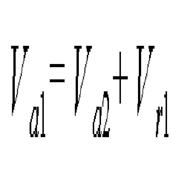
수학식3에서, Va1은 송신이동체의 절대속도, Va2는 수신이동체의 절대속도, Vr1은 송신이동체의 상대속도를 나타낸다.In Equation 3, V a1 represents the absolute speed of the transmitting mobile, V a2 represents the absolute speed of the receiving mobile, and V r1 represents the relative speed of the transmitting mobile.
해당 이동체들은 본인의 탐지 정보를 송신할 때에, 통신 요청 메시지에 포함됐던 식별자를 그대로 사용한다. 전술한 과정들이 모두 완료되면, 전처리부(120)는 파악된 ID를 송신부(130)와 수신부(140)에, 메타정보는 센서융합 처리부(150)에 전달한다. 송신부(130)에서는 전달받은 식별자를 사용해서 그 식별자를 갖는 통신 대상 이동체에 탐지정보에 대한 요청 메시지를 전송하고, 수신부(140)에서는 타 이동체로부터 수신된 여러 정보들 중 전처리부(120)로부터 전달받은 유효한 식별자를 지닌 정보만을 센서융합 처리부(150)에 보내준다.When the mobile device transmits its own detection information, it uses the identifier included in the communication request message . When all the above-described processes are completed, the
GPS를 이용해 ID를 생성할 경우, 이동체의 탐지영역 확장 시스템(100)은 통신 대상에 탐지정보를 요청하여 통신 대상으로부터 탐지정보를 수신할 때, 각 이동체들이 주행하고 있으므로 위치가 변한다는 점을 고려하여, ID의 절대적 위치에서 이동체의 이동에 따라 변한 위치와의 거리 차가 특정 임계값 이하이면 수신된 탐지 정보가 통신대상이었던 해당 이동체로부터 수신된 것으로 인식할 수 있다.When generating ID using GPS, the detection
이어, 이동체의 탐지영역 확장 시스템(100)은 센서융합 처리부(150)를 통해 메타정보와 탐지정보를 융합하여 최종 메타정보를 생성한다(S650).Subsequently, the detection
타 이동체로부터 수신된 탐지정보는 본 이동체로부터 특정 거리 이상 떨어진 곳을 기준으로 탐지한 자료이며, 이동방향 역시 현재 이동체와 다를 수 있기 때문에 그 정보를 그대로 사용하지 않고 메타정보와 융합하여 최종 메타정보를 생성할 수 있다. The detection information received from other moving objects is the data detected based on the distance away from the moving object by a certain distance, and since the moving direction may be different from the current moving object, the final meta information is merged with the meta information without using the information as it is. Can be generated.
센서융합 처리부(150)는 메타정보와 수신된 타 이동체의 탐지정보를 융합하여 결합시켜준다. 타 이동체들로부터 수신된 정보는 그 이동체들이 주행하던 위치와 방향을 기준으로 수집된 정보이다. 그리고 그 위치는 현 이동체가 감지할 수 있는 영역의 끝부분이므로, 현 이동체의 센서에 탐지된 데이터의 가장자리 부분에 타 이동체로부터 수신된 정보를 이어주는 방식으로 조합이 된다. 따라서, 센서융합 처리부(150)는 이러한 동작을 처리하는 마이크로 프로세서를 포함할 수 있으며, 이 때 메타 정보에 들어있는 타 이동체들의 거리, 방향 정보가 사용된다. The sensor
즉, 도 8에 도시된 바와 같이, 수신된 정보가 현 위치로부터 어느 정도 떨어진 곳에서, 어떤 방향을 바라보고 탐지된 정보인지를 반영해서 현 이동체의 탐지정보에 융합시켜주는 것이다. 도 8을 참조하면 S는 현 이동체이고 a는 s가 통신을 요청한 통신 대상 이동체이다. 도 8에 도시된 바와 같이 a는 s의 방향으로부터 θ만큼 회전된 방향을 향해 탐지한 정보를 송신하는데, s가 이 θ를 알고 있어서 a로부터 수신된 1,2번 이동체의 좌표를 (y3+y1cosθ, x3+x1sinθ), (y3+y2cosθ, x3+x2sinθ)와 같이 현 s의 위치와 방향을 기준으로 수정한다는 것이다. 도 8은 본 발명의 실시예에 따라 통신 대상 이동체로부터 수신된 정보가 현 위치로부터 어느 정도 떨어진 곳에서 어떤 방향을 바라보고 탐지된 정보인지를 반영해 레이저 탐지 정보를 융합시키는 예를 나타낸 도면이다.That is, as shown in FIG. 8, the received information reflects in what direction the detected information is located at a certain distance from the current position, and fuses the detection information of the current moving object. Referring to Figure 8, S is the current mobile and a is the communication target mobile that s requested communication. As shown in FIG. 8, a transmits the detected information from the direction of s toward the direction rotated by θ, and s knows this θ so that the coordinates of the moving
그런데 이러한 데이터 융합시, 중복되는 정보가 있을 수 있다. 즉, 도 7에서처럼 대상 이동체가 센싱 영역 가장 바깥쪽에 있지 않을 가능성이 있다. 이러한 경우 도 7에 표시된 부분처럼 현 이동체와 대상이동체의 탐지영역이 겹치는 영역이 존재하고, 이동체 e.1은 S이동체에 의해서는 e의 ID를, a이동체에 의해서는 1의 식별자를 부여받은 동일한 이동체일 때 이에 대한 처리는 중요하고, 이처럼 데이터의 중복은 전술한 바와 같이 대상 이동체가 센싱영역 내에 존재할 때 발생한다. 본 발명은 센서의 탐지 가능영역이 어느 정도인지 정확히 알고 있고, 탐지된 이동체의 위치 역시 파악할 수 있다. 그러므로 수신된 데이터가 탐지영역 가장자리의 이동체로부터 송신된 것인지 그렇지 않은지를 파악하는 것이 첫 번째 단계가 되고, 이는 앞서 기술한 데이터의 조합 이전 단계에 이루어진다. 이동체 e.1처럼 중첩되는 영역에 존재하는 이동체는 이처럼 두 이동체 s(현 이동체), a(대상 이동체)에 의해 다른 식별자를 부여 받았지만 실제로는 동일한 이동체이다. 이는 s로부터는 (x1, y1)만큼의 거리에, a로부터는 (0,y2)만큼의 거리에 존재한다. 또한 a는 s로부터 (x1, y1-y2)만큼의 거리에 존재하므로 s는 자신이 탐지한 이동체 e와 a가 탐지한 이동체1((0,y2)의 좌표를 갖는)이 동일한 이동체라고 판단할 수 있다. 이 때도 역시 모든 이동체가 주행하고 있다는 점을 감안하여 특정 임계값 τ를 주고 s에 의해 탐지된 이동체 (e.1)의 위치와 a에 의해 탐지된 위치의 거리 차이가 τ이하라면 동일한 이동체라 판단하도록 할 수 있다. However, in such data fusion, there may be overlapping information. That is, as shown in FIG. 7, there is a possibility that the target moving object is not at the outermost side of the sensing area. In this case, as shown in Fig. 7, there exists an area where the detection area of the current moving object and the target moving object overlap, and the moving object e.1 is assigned the ID of e by the S moving object and the identifier of 1 by the moving object a. When the moving object is processed, this is important, and the duplication of data as described above occurs when the target moving object exists in the sensing area. The present invention accurately knows the detectable area of the sensor and can also detect the position of the detected moving object. Therefore, determining whether or not the received data is transmitted from the moving object at the edge of the detection area is the first step, which is performed before the combination of the above-described data. The moving object existing in the overlapping area as in the moving object e.1 is given different identifiers by the two moving objects s (current moving object) and a (target moving object), but is actually the same moving object. It is at a distance of (x 1 , y 1 ) from s and at a distance of (0, y 2 ) from a. Also, since a exists at a distance of (x 1 , y 1 -y 2 ) from s, s is the same as moving object e detected by itself and moving object 1 (with coordinates of (0, y 2 )) detected by a. It can be determined that the mobile body. In this case as well, considering that all the moving vehicles are traveling, a certain threshold value τ is given, and if the distance difference between the position of the moving object (e.1) detected by s and the position detected by a is less than τ, it is determined to be the same moving object. You can do that.
동일한 이동체가라고 판단되는 두 정보 사이에는 최대 τ만큼의 오차가 있게 되어 이들 정보를 하나로 병합해야 한다. 그 병합 방법은 다음 수학식4와 같다.There is a maximum error of τ between two pieces of information determined to be the same moving object, and the pieces of information must be merged into one. The merging method is as follows.


또한, 이동체의 탐지거리 확장 시스템(100)은 수신된 탐지정보에 근거해 탐지된 이동체들의 방향을 측정할 때, 짧은 시간 간격으로 전방 이동체를 탐지하여 그 궤적을 벡터로 나타내어 현 이동체와의 방향 차이를 분석할 수 있다.In addition, when the detection
또한, 이동체의 탐지영역 확장 시스템(100)은 메타정보와 탐지정보를 융합할 때, 타 이동체로부터 수신된 탐지정보를, 현 이동체의 메타정보에 포함된 전방 이동체와의 거리, 방향 차이를 반영하여 현 이동체의 위치와 방향을 기준으로 수정하여 최종 메타정보를 생성할 수 있다.In addition, when the detection
또한, 이동체의 탐지영역 확장 시스템(100)은 전방 이동체의 속도, 방향, 거리 정보를 포함하는 메타정보와 타 이동체로부터 수신된 타 이동체의 탐지정보를 현 위치를 기준으로 융합하여 최종 메타정보를 생성할 수 있다.In addition, the detection
그리고, 이동체의 탐지영역 확장 시스템(100)은 메타정보와 탐지정보의 융합 시, 중복되는 정보를 처리할 때, 탐지정보를 송신한 이동체가 현 이동체의 탐지 영역 바깥이 아닌 내부에 있는지 여부를 먼저 판단하고, 탐지 영역 내부에 이동체가 있을 경우 현 이동체의 센서에 탐지된 특정 이동체의 좌표와, 현 위치를 기준으로 수정된 타 이동체의 탐지정보에 포함된 특정 이동체의 좌표차가 특정 임계값 이하이면 동일한 이동체에서 수신된 탐지정보로 처리할 수 있다.
이어, 이동체의 탐지영역 확장 시스템(100)은 최종 메타정보를 송신부(130) 또는 출력부(160)에 출력한다(S660).
따라서, 현 이동체에서 운전자는 출력부(160)를 통해 현 이동체의 탐지정보에 다른 이동체로부터 수신한 탐지정보를 합하여 더 확장된 탐지 정보를 확인할 수 있다.In addition, when the detection
Subsequently, the detection
Therefore, in the current moving object, the driver may check detection information of the current moving object through the
삭제delete
삭제delete
또한, 운전자는 출력부(160)에 디스플레이되는 탐지정보에 대해 입력부(170)를 통해 탐지 영역을 확장하거나, 탐지 영역을 제한해서 볼 수 있다. 즉, 센서융합 처리부(150)는 입력부(170)로부터 외부 입력을 받을 수 있다. 이는 운전자가 보기를 원하는 데이터의 범위에 대한 정보이다. 극단적인 예로 전방 이동체들이 연속적으로 존재해서 통신을 이용해 얻을 수 있는 정보가 무한히 발산해 나가는 경우에 그 최대치를 정해 줄 필요가 있기 때문이다. 이 설정은 시스템의 사용자인 운전자가 입력부(170)를 통해 입력할 수 있고, 그 값을 받아 센서융합 처리부(150)에서는 적절한 범위에서 데이터들을 결합시켜준다.In addition, the driver may expand the detection area or limit the detection area through the
위의 모든 과정들이 끝나면, 최종 메타정보가 출력부(160)와 송신부(130)로 전달된다. 송신부(130)로 전달된 메타정보는, 현 이동체의 후방으로부터 들어온 통신 요청에 응하여 송신될 수 있다.After all the above processes, the final meta information is transmitted to the
본 발명의 실시예에서는 차량을 예로 들어 설명하였으나, 이에 국한되지 않고 바다를 항해하는 선박이나, 하늘을 비행하는 비행체, 우주를 항해하는 우주선 등에도 동일하게 적용할 수 있다.In the embodiment of the present invention has been described by taking a vehicle as an example, it is equally applicable to a ship sailing the sea, a vehicle flying in the sky, a spacecraft sailing in space, and the like.
전술한 바와 같이 본 발명에 의하면, 이동체간 및 이동체와 기지국간 통신을 이용해 기존의 단일 센서가 갖는 제한된 탐지영역이라는 한계를 극복하고 사고 발생과 트래픽 체증을 완화시킴으로써 보다 효율적인 트래픽 환경을 조성하는데 일조하기 위해, 한 이동체의 탐지 영역 내에 있는 다른 이동체와의 무선 통신을 통해 그 이동체의 탐지정보를 수신하고, 수신된 탐지정보를 기존 탐지정보와 융합하여 원 센서의 탐지영역을 확장할 수 있도록 된, 통신을 이용한 이동체의 탐지영역 확장 방법 및 시스템을 실현할 수 있다.
본 발명이 속하는 기술분야의 당업자는 본 발명이 그 기술적 사상이나 필수적 특징을 변경하지 않고서 다른 구체적인 형태로 실시될 수 있으므로, 이상에서 기술한 실시예들은 모든 면에서 예시적인 것이며 한정적인 것이 아닌 것으로서 이해해야만 한다. 본 발명의 범위는 상기 상세한 설명보다는 후술하는 특허청구범위에 의하여 나타내어지며, 특허청구범위의 의미 및 범위 그리고 그 등가개념으로부터 도출되는 모든 변경 또는 변형된 형태가 본 발명의 범위에 포함되는 것으로 해석되어야 한다.
As described above, the present invention overcomes the limitation of the limited detection area of a single sensor by using communication between mobiles and between mobiles and base stations, and helps to create a more efficient traffic environment by mitigating accidents and congestion. In order to receive the detection information of the moving object through wireless communication with the other moving object within the detection area of one moving object, the detection area of the original sensor can be expanded by fusing the received detection information with the existing detection information. It is possible to realize a method and a system for expanding a detection area of a moving object using the APC.
As those skilled in the art to which the present invention pertains may implement the present invention in other specific forms without changing the technical spirit or essential features, the embodiments described above are intended to be illustrative in all respects and should not be considered as limiting. Should be. The scope of the present invention is shown by the following claims rather than the detailed description, and all changes or modifications derived from the meaning and scope of the claims and their equivalents should be construed as being included in the scope of the present invention. do.
삭제delete
본 발명은 도로나 해상 그리고 하늘에서 이동하며 레이더나 비전센서와 같이 거리, 속도, 가시 정보를 통해 주변 트래픽 정보를 탐지하는 차량, 선박, 항공기 등의 이동체에 적용할 수 있다.
The present invention can be applied to a moving object such as a vehicle, a ship, or an aircraft moving on a road, at sea, and in the sky and detecting surrounding traffic information through distance, speed, and visual information such as a radar or a vision sensor.
100 : 이동체의 탐지영역 확장 시스템 110 : 센싱부
120 : 전처리부 130 : 송신부
140 : 수신부 150 : 센서융합 처리부
160 : 출력부 170 : 입력부100: detection area expansion system of the moving object 110: sensing unit
120: preprocessor 130: transmitter
140
160: output unit 170: input unit
Claims (22)
상기 탐지된 트래픽 정보를 처리하여 메타정보를 생성하는 전처리부;
외부로부터 전송되어 온 탐지 정보를 수신하는 수신부;
상기 메타정보와 상기 탐지 정보를 융합하여 최종 메타정보를 생성하는 센서융합 처리부; 및
상기 최종 메타정보를 출력하는 출력부;
를 포함하는 이동체의 탐지영역 확장 시스템.
Sensing unit for detecting traffic information in a specific area;
A preprocessor configured to process the detected traffic information to generate meta information;
Receiving unit for receiving the detection information transmitted from the outside;
A sensor fusion processor configured to fuse the meta information and the detection information to generate final meta information; And
An output unit for outputting the final meta information;
Detection zone expansion system of a moving object comprising a.
상기 최종 메타정보를 외부로 송출하기 위한 송신부;
를 더 포함하는 것을 특징으로 하는 이동체의 탐지영역 확장 시스템.
The method of claim 1,
A transmitter for transmitting the final meta information to the outside;
Detection area expansion system of a moving object further comprises.
상기 센싱부는, 이동체 전면의 서로 다른 위치에 한 개 이상의 센서를 구비하고, 이동체 인근에 다른 이동체가 있더라도 상기 한 개 이상의 센서를 통해 상기 다른 이동체 너머의 영역까지 트래픽 정보를 탐지하는 것을 특징으로 하는 이동체의 탐지영역 확장 시스템.
The method of claim 1,
The sensing unit includes one or more sensors at different positions in front of the moving object, and detects traffic information to the area beyond the other moving object through the one or more sensors even if there are other moving objects in the vicinity of the moving object. Detection area expansion system.
상기 전처리부는 GPS 위성으로부터 위치 정보를 수신하여 이동체의 절대적 위치 정보를 획득하는 GPS 모듈을 포함하는 것을 특징으로 하는 이동체의 탐지영역 확장 시스템.
The method of claim 1,
The preprocessor includes a GPS module for receiving the position information from the GPS satellites to obtain the absolute position information of the moving object.
상기 전처리부는, 상기 센싱부로부터 탐지된 트래픽 정보들 중, 이동체의 직접적인 트래픽 정보 외의 다른 정보들을 걸러내어 트래픽 정보의 용량을 최소화하고, 이렇게 얻어진 트래픽 정보를 바탕으로 탐지된 이동체들의 속도 및 방향을 측정하며, 탐지된 이동체들에 특정 ID를 부여하는 마이크로 프로세서를 포함하는 것을 특징으로 하는 이동체의 탐지영역 확장 시스템.
The method of claim 1,
The preprocessor minimizes the capacity of the traffic information by filtering other information than the direct traffic information of the moving object among the traffic information detected by the sensing unit, and measures the speed and direction of the detected moving objects based on the traffic information thus obtained. And a microprocessor for assigning specific IDs to the detected moving objects.
상기 센서융합 처리부는, 상기 전처리부에서 생성된 상기 메타정보와, 타 이동체로부터 수신된 상기 탐지 정보를 현재 위치를 기준으로 융합해 상기 최종 메타정보를 생성하는 것을 특징으로 하는 이동체의 탐지영역 확장 시스템.
The method of claim 1,
The sensor fusion processor is configured to fuse the meta information generated by the preprocessor and the detection information received from another mobile object based on a current position to generate the final meta information. .
상기 메타정보는 전방 이동체의 속도, 방향, 거리, 좌표 정보를 포함하는 것을 특징으로 하는 이동체의 탐지영역 확장 시스템.
The method according to claim 6,
The meta information includes the speed, direction, distance, coordinate information of the front moving object detection system expansion system of the moving object.
상기 센서융합 처리부는, 타 이동체로부터 수신된 상기 탐지 정보를 상기 메타정보에 포함된 전방 이동체와의 거리, 방향 차이를 반영하여 현 이동체의 위치와 방향을 기준으로 수정하여 상기 최종 메타정보를 생성하는 것을 특징으로 하는 이동체의 탐지영역 확장 시스템.
The method according to claim 6,
The sensor fusion processing unit generates the final meta information by modifying the detection information received from another moving object based on the position and direction of the current moving object by reflecting the distance and the direction difference with the front moving object included in the meta information. Detection area expansion system of a moving object, characterized in that.
상기 센서융합 처리부는, 상기 메타 정보와 상기 수신된 탐지 정보의 융합 시에 중복된 데이터가 발생될 경우에, 상기 수신된 탐지 정보를 송신한 이동체가 현 이동체의 탐지영역 바깥이 아닌 내부에 있는지 여부를 먼저 판단하고, 탐지영역 내부에 이동체가 있을 경우 현 이동체에 탐지된 특정 이동체의 좌표와, 현 위치를 기준으로 수정된 타 이동체의 탐지정보에 포함된 특정 이동체의 좌표차가 특정 임계값 이하라면 동일한 이동체로 처리하는 것을 특징으로 하는 이동체의 탐지영역 확장 시스템.
The method according to claim 6,
The sensor fusion processing unit, when duplicated data is generated during the fusion of the meta information and the received detection information, whether or not the moving object transmitting the received detection information is not inside the detection area of the current moving object; First, if the moving object is located inside the detection area, the coordinate of the specific moving object detected in the current moving object and the coordinate difference of the specific moving object included in the detection information of the other moving object modified based on the current position are equal to or less than the specific threshold value. A detection zone expansion system for a moving object, characterized in that the processing by the moving object.
상기 최종 메타정보에 근거한 탐지 확장 영역을 확인하거나 제한할 수 있는 명령을 입력받기 위한 입력부;
를 더 포함하는 것을 특징으로 하는 이동체의 탐지영역 확장 시스템.
The method of claim 1,
An input unit for receiving a command for checking or limiting a detection extension area based on the final meta information;
Detection area expansion system of a moving object further comprises.
(b) 상기 탐지된 트래픽 정보를 처리하여 메타정보를 생성하는 단계;
(c) 상기 트래픽 정보에 근거해 탐지 정보를 요청할 통신 대상을 결정하는 단계;
(d) 상기 통신 대상에 요청하여, 상기 통신 대상으로부터 탐지 정보를 수신하는 단계;
(e) 상기 메타정보와 상기 탐지 정보를 융합하여 최종 메타정보를 생성하는 단계; 및
(f) 상기 최종 메타정보를 출력하는 단계;
를 포함하는 이동체의 탐지영역 확장 방법.
(a) detecting traffic information in a specific area;
(b) processing the detected traffic information to generate meta information;
(c) determining a communication target to request detection information based on the traffic information;
(d) requesting the communication object to receive detection information from the communication object;
(e) fusing the meta information and the detection information to generate final meta information; And
(f) outputting the final meta information;
Method of expanding the detection area of the moving object comprising a.
상기 (e) 단계는, 상기 수신된 탐지 정보에서 이동체의 직접적인 정보 외의 다른 정보들을 걸러내어 데이터의 용량을 최소화하여 얻은 데이터를 바탕으로, 탐지된 이동체들의 속도 및 방향을 측정하며, 탐지된 이동체들에 특정 ID를 부여하는 것을 특징으로 하는 이동체의 탐지영역 확장 방법.
The method of claim 11,
Step (e) measures the speed and direction of the detected moving objects based on the data obtained by filtering out information other than the direct information of the moving object from the received detection information and minimizing the capacity of the data. A method for expanding a detection area of a moving object, which assigns a specific ID to the moving object.
상기 (e) 단계는, 상기 수신된 탐지 정보에 근거해 탐지된 이동체들의 방향을 측정할 때, 짧은 시간 간격으로 전방 이동체를 탐지하여 그 궤적을 벡터로 나타내어 현 이동체와의 방향 차이를 분석하는 것을 특징으로 하는 이동체의 탐지영역 확장 방법.
The method of claim 11,
In the step (e), when the direction of the detected moving objects is measured based on the received detection information, the front moving object is detected at a short time interval, and the trajectory is represented by a vector to analyze the direction difference with the current moving object. Characterized in that the detection area expansion method of the moving object.
상기 (c) 단계는, 상기 트래픽 정보에 근거해 탐지 정보를 요청할 통신 대상을 선택할 때, 전방의 모든 이동체들에게 통신 요청을 하지 않고, 현 이동체에 탐지된 타 이동체들의 위치, 방향, 탐지 가능 영역에 근거하여, 현 이동체로부터 가장 멀리 떨어져 있고, 서로의 탐지 영역이 가장 겹치지 않는 이동체들을 통신 대상으로 결정하는 것을 특징으로 하는 이동체의 탐지영역 확장 방법.
The method of claim 11,
In the step (c), when selecting a communication target to request detection information based on the traffic information, the location, direction, and detectable area of other moving objects detected in the current moving object without making a communication request to all the moving objects ahead. And determining, as the communication targets, moving objects that are farthest from the current moving object and whose detection areas do not overlap with each other as the communication target.
상기 (c) 단계는 상기 통신 대상을 결정할 때, GPS 정보와 상기 탐지 정보에 근거하여, 전방 이동체의 절대적 위치(위도/경도)를 파악하고, 상기 절대적 위치(위도/경도)를 ID로 사용하여 상기 통신 대상을 결정하며,
상기 (d) 단계는 상기 통신 대상에 상기 탐지 정보를 요청하여 상기 통신 대상으로부터 상기 탐지 정보를 수신할 때, 각 이동체들이 주행하고 있으므로 위치가 변한다는 점을 고려하여, 상기 ID의 절대적 위치에서 상기 이동체의 이동에 따라 변한 위치와의 거리 차가 특정 임계값 이하이면 수신된 탐지 정보가 통신대상이었던 해당 이동체로부터 송신된 것으로 인식하는 것을 특징으로 하는 이동체의 탐지영역 확장 방법.
The method of claim 11,
In the step (c), when determining the communication target, the absolute position (latitude / longitude) of the front moving object is determined based on the GPS information and the detection information, and the absolute position (latitude / longitude) is used as the ID. Determine the communication target,
In step (d), the mobile station is traveling, and the position changes when the detection information is requested from the communication object to receive the detection information from the communication object. And detecting the received detection information as being transmitted from the corresponding mobile object which is the communication target, when the distance difference with the position changed according to the movement of the mobile object is less than or equal to a certain threshold value.
상기 (c) 단계는 상기 통신 대상을 결정할 때, 전방 이동체의 속도 정보를 ID로 사용하여 상기 통신 대상을 결정하는 것을 특징으로 하는 이동체의 탐지영역 확장 방법.
The method of claim 11,
In the step (c), when the communication target is determined, the communication target is determined using the speed information of the front mobile body as an ID.
상기 (e) 단계는, 상기 메타정보와 상기 탐지 정보를 융합할 때, 타 이동체로부터 수신된 탐지 정보를, 현 이동체의 메타정보에 포함된 전방 이동체와의 거리, 방향 차이를 반영하여 현 이동체의 위치와 방향을 기준으로 수정하여 상기 최종 메타정보를 생성하는 것을 특징으로 하는 이동체의 탐지영역 확장 방법.
The method of claim 11,
In the step (e), when the meta information and the detection information are fused, detection information received from another moving object is reflected by a distance and a direction difference with the front moving object included in the meta information of the current moving object. And modifying the location based on the position and the direction to generate the final meta information.
상기 (e) 단계는 전방 이동체의 속도, 방향, 거리 정보를 포함하는 상기 메타정보와 타 이동체로부터 수신된 타 이동체의 상기 탐지 정보를 현 위치를 기준으로 융합하여 상기 최종 메타정보를 생성하는 것을 특징으로 하는 이동체의 탐지영역 확장 방법.
The method of claim 11,
In the step (e), the final meta information is generated by fusing the meta information including the speed, direction, and distance information of the front moving object with the detection information of the other moving object received from another moving object based on the current position. Method of expanding the detection area of the moving object.
상기 (e) 단계는 상기 메타정보와 상기 탐지 정보의 융합 시, 중복되는 정보를 처리할 때, 상기 탐지 정보를 송신한 이동체가 현 이동체의 탐지 영역 바깥이 아닌 내부에 있는지 여부를 먼저 판단하고, 탐지 영역 내부에 이동체가 있을 경우 현 이동체에 탐지된 특정 이동체의 좌표와, 현 위치를 기준으로 수정된 타 이동체의 탐지정보에 포함된 특정 이동체의 좌표차가 특정 임계값 이하이면 동일한 이동체에서 수신된 탐지 정보로 처리하는 것을 특징으로 하는 이동체의 탐지영역 확장 방법.
The method of claim 11,
In the step (e), when processing the overlapping information in the fusion of the meta information and the detection information, first determine whether the moving object transmitting the detection information is not inside the detection area of the current moving object, If there is a moving object inside the detection area, if the coordinate difference of the specific moving object detected in the current moving object and the coordinate difference of the specific moving object included in the detection information of the other moving object modified based on the current position is less than a certain threshold, the detection received from the same moving object. Method of expanding the detection area of a moving object, characterized in that to process the information.
상기 (d) 단계는 상기 통신 대상으로 통신 가능 영역 밖의 차량에게도 멀티홉 방식으로 탐지 정보를 요청하여 수신하는 것을 특징으로 하는 이동체의 탐지영역 확장 방법.
The method of claim 11,
The step (d) is a method for expanding the detection area of a moving object, characterized in that to receive and request the detection information in a multi-hop manner to the vehicle outside the communication area to the communication target.
상기 (d) 단계는 특정한 요청이 없어도 주변 차량으로부터 정기적으로 탐지 정보를 수신할 시, 상기 통신 대상을 결정하여 탐지 정보를 요청하지 않고 상기 주변 차량으로부터 정기적으로 수신된 탐지 정보를 이용하는 것을 특징으로 하는 이동체의 탐지영역 확장 방법.
The method of claim 11,
Step (d) is characterized in that when receiving detection information from the surrounding vehicles at regular intervals even without a specific request, it determines the communication target and uses the detection information periodically received from the surrounding vehicles without requesting the detection information. Method of expanding the detection area of a moving object.
상기 (d) 단계는 다른 이동체와의 통신뿐만 아니라 이동체와 기지국간 통신을 통해서도 상기 탐지 정보를 수신하는 것을 특징으로 하는 이동체의 탐지영역 확장 방법.
The method of claim 11,
The step (d) is a method for expanding the detection area of a mobile object, characterized in that the detection information is received through communication between the mobile station and the base station as well as other mobile.
Priority Applications (1)
| Application Number | Priority Date | Filing Date | Title |
|---|---|---|---|
| KR1020100084936A KR101123737B1 (en) | 2010-08-31 | 2010-08-31 | Method for extension of vehicle sensing range through communication, and system thereof |
Applications Claiming Priority (1)
| Application Number | Priority Date | Filing Date | Title |
|---|---|---|---|
| KR1020100084936A KR101123737B1 (en) | 2010-08-31 | 2010-08-31 | Method for extension of vehicle sensing range through communication, and system thereof |
Publications (2)
| Publication Number | Publication Date |
|---|---|
| KR20120020971A KR20120020971A (en) | 2012-03-08 |
| KR101123737B1 true KR101123737B1 (en) | 2012-03-16 |
Family
ID=46129462
Family Applications (1)
| Application Number | Title | Priority Date | Filing Date |
|---|---|---|---|
| KR1020100084936A Expired - Fee Related KR101123737B1 (en) | 2010-08-31 | 2010-08-31 | Method for extension of vehicle sensing range through communication, and system thereof |
Country Status (1)
| Country | Link |
|---|---|
| KR (1) | KR101123737B1 (en) |
Cited By (1)
| Publication number | Priority date | Publication date | Assignee | Title |
|---|---|---|---|---|
| KR20150127522A (en) | 2014-05-07 | 2015-11-17 | 서울대학교산학협력단 | Method and system for detecting nearby vehicle using cooperative commmunication |
Families Citing this family (2)
| Publication number | Priority date | Publication date | Assignee | Title |
|---|---|---|---|---|
| KR101857691B1 (en) * | 2016-10-17 | 2018-05-15 | 고려대학교 산학협력단 | Method and appratus for detecting anomaly of vehicle based on euclidean distance measure |
| DE102020207065B3 (en) * | 2020-06-05 | 2021-02-11 | Volkswagen Aktiengesellschaft | Vehicle, method, computer program and device for merging object information about one or more objects in the surroundings of a vehicle |
Citations (3)
| Publication number | Priority date | Publication date | Assignee | Title |
|---|---|---|---|---|
| JP2008090663A (en) | 2006-10-03 | 2008-04-17 | Denso Corp | Inter-vehicle communication system |
| JP2010043960A (en) | 2008-08-13 | 2010-02-25 | Nissan Motor Co Ltd | System and method for detecting situation of movement of vehicle |
| KR20100062068A (en) * | 2008-12-01 | 2010-06-10 | 한국기술교육대학교 산학협력단 | Method to extend coverage area of moving object with sensor |
-
2010
- 2010-08-31 KR KR1020100084936A patent/KR101123737B1/en not_active Expired - Fee Related
Patent Citations (3)
| Publication number | Priority date | Publication date | Assignee | Title |
|---|---|---|---|---|
| JP2008090663A (en) | 2006-10-03 | 2008-04-17 | Denso Corp | Inter-vehicle communication system |
| JP2010043960A (en) | 2008-08-13 | 2010-02-25 | Nissan Motor Co Ltd | System and method for detecting situation of movement of vehicle |
| KR20100062068A (en) * | 2008-12-01 | 2010-06-10 | 한국기술교육대학교 산학협력단 | Method to extend coverage area of moving object with sensor |
Cited By (1)
| Publication number | Priority date | Publication date | Assignee | Title |
|---|---|---|---|---|
| KR20150127522A (en) | 2014-05-07 | 2015-11-17 | 서울대학교산학협력단 | Method and system for detecting nearby vehicle using cooperative commmunication |
Also Published As
| Publication number | Publication date |
|---|---|
| KR20120020971A (en) | 2012-03-08 |
Similar Documents
| Publication | Publication Date | Title |
|---|---|---|
| US9896094B2 (en) | Collision avoidance control system and control method | |
| US8362889B2 (en) | Road condition detecting system | |
| JP3766909B2 (en) | Driving environment recognition method and apparatus | |
| US10510256B2 (en) | Vehicle collision avoidance system and method | |
| JP6219312B2 (en) | Method for determining the position of a vehicle in a lane traffic path of a road lane and a method for detecting alignment and collision risk between two vehicles | |
| US7873474B2 (en) | Driving assist system for vehicle | |
| US8229663B2 (en) | Combined vehicle-to-vehicle communication and object detection sensing | |
| US7133768B2 (en) | Vehicular driving support system and vehicular control system | |
| JP3087606B2 (en) | Apparatus and method for measuring distance between vehicles | |
| CN113386752B (en) | Method and device for determining an optimal cruising lane in a driver assistance system | |
| CN101625797B (en) | A kind of early warning method and early warning device when the car approaches at high speed | |
| KR20200102004A (en) | Apparatus, system and method for preventing collision | |
| CN106415693A (en) | Cognitive notification device for vehicles, Cognitive notification system for vehicles | |
| JP4134803B2 (en) | Automotive electronic devices | |
| JP4684960B2 (en) | Vehicle collision prevention support system | |
| KR20230136821A (en) | Advanced Driver Assistance System, and Vehicle having the same | |
| KR101123737B1 (en) | Method for extension of vehicle sensing range through communication, and system thereof | |
| KR20190071408A (en) | Apparatus and method for detecting distance and speed difference between vehicles using ultrasonic sensor | |
| JPH06180799A (en) | Method for information communication with on-road vehicle | |
| Huang et al. | Design and implementation of a cooperative collision warning system | |
| KR20120060511A (en) | Apparatus and method for warning collision in vehicle | |
| JP4961991B2 (en) | Vehicle periphery monitoring device | |
| JP2008152391A (en) | Vehicle periphery monitoring device | |
| JP7294199B2 (en) | Communication device, communication system, vehicle, communication program, and communication method | |
| Sathiyan et al. | A comprehensive review on cruise control for intelligent vehicles |
Legal Events
| Date | Code | Title | Description |
|---|---|---|---|
| A201 | Request for examination | ||
| PA0109 | Patent application |
St.27 status event code: A-0-1-A10-A12-nap-PA0109 |
|
| PA0201 | Request for examination |
St.27 status event code: A-1-2-D10-D11-exm-PA0201 |
|
| P11-X000 | Amendment of application requested |
St.27 status event code: A-2-2-P10-P11-nap-X000 |
|
| P13-X000 | Application amended |
St.27 status event code: A-2-2-P10-P13-nap-X000 |
|
| P11-X000 | Amendment of application requested |
St.27 status event code: A-2-2-P10-P11-nap-X000 |
|
| P13-X000 | Application amended |
St.27 status event code: A-2-2-P10-P13-nap-X000 |
|
| PN2301 | Change of applicant |
St.27 status event code: A-3-3-R10-R13-asn-PN2301 St.27 status event code: A-3-3-R10-R11-asn-PN2301 |
|
| D13-X000 | Search requested |
St.27 status event code: A-1-2-D10-D13-srh-X000 |
|
| D14-X000 | Search report completed |
St.27 status event code: A-1-2-D10-D14-srh-X000 |
|
| E701 | Decision to grant or registration of patent right | ||
| PE0701 | Decision of registration |
St.27 status event code: A-1-2-D10-D22-exm-PE0701 |
|
| GRNT | Written decision to grant | ||
| PR0701 | Registration of establishment |
St.27 status event code: A-2-4-F10-F11-exm-PR0701 |
|
| PR1002 | Payment of registration fee |
St.27 status event code: A-2-2-U10-U11-oth-PR1002 Fee payment year number: 1 |
|
| PG1501 | Laying open of application |
St.27 status event code: A-1-1-Q10-Q12-nap-PG1501 |
|
| PG1601 | Publication of registration |
St.27 status event code: A-4-4-Q10-Q13-nap-PG1601 |
|
| R18-X000 | Changes to party contact information recorded |
St.27 status event code: A-5-5-R10-R18-oth-X000 |
|
| FPAY | Annual fee payment |
Payment date: 20150212 Year of fee payment: 4 |
|
| PR1001 | Payment of annual fee |
St.27 status event code: A-4-4-U10-U11-oth-PR1001 Fee payment year number: 4 |
|
| PN2301 | Change of applicant |
St.27 status event code: A-5-5-R10-R13-asn-PN2301 St.27 status event code: A-5-5-R10-R11-asn-PN2301 |
|
| PN2301 | Change of applicant |
St.27 status event code: A-5-5-R10-R13-asn-PN2301 St.27 status event code: A-5-5-R10-R11-asn-PN2301 |
|
| FPAY | Annual fee payment |
Payment date: 20160112 Year of fee payment: 5 |
|
| PR1001 | Payment of annual fee |
St.27 status event code: A-4-4-U10-U11-oth-PR1001 Fee payment year number: 5 |
|
| P22-X000 | Classification modified |
St.27 status event code: A-4-4-P10-P22-nap-X000 |
|
| PR1001 | Payment of annual fee |
St.27 status event code: A-4-4-U10-U11-oth-PR1001 Fee payment year number: 6 |
|
| FPAY | Annual fee payment |
Payment date: 20180129 Year of fee payment: 7 |
|
| PR1001 | Payment of annual fee |
St.27 status event code: A-4-4-U10-U11-oth-PR1001 Fee payment year number: 7 |
|
| FPAY | Annual fee payment |
Payment date: 20190201 Year of fee payment: 8 |
|
| PR1001 | Payment of annual fee |
St.27 status event code: A-4-4-U10-U11-oth-PR1001 Fee payment year number: 8 |
|
| R18-X000 | Changes to party contact information recorded |
St.27 status event code: A-5-5-R10-R18-oth-X000 |
|
| R18-X000 | Changes to party contact information recorded |
St.27 status event code: A-5-5-R10-R18-oth-X000 |
|
| PN2301 | Change of applicant |
St.27 status event code: A-5-5-R10-R13-asn-PN2301 St.27 status event code: A-5-5-R10-R11-asn-PN2301 |
|
| FPAY | Annual fee payment |
Payment date: 20200203 Year of fee payment: 9 |
|
| PR1001 | Payment of annual fee |
St.27 status event code: A-4-4-U10-U11-oth-PR1001 Fee payment year number: 9 |
|
| PN2301 | Change of applicant |
St.27 status event code: A-5-5-R10-R13-asn-PN2301 St.27 status event code: A-5-5-R10-R11-asn-PN2301 |
|
| PR1001 | Payment of annual fee |
St.27 status event code: A-4-4-U10-U11-oth-PR1001 Fee payment year number: 10 |
|
| R18-X000 | Changes to party contact information recorded |
St.27 status event code: A-5-5-R10-R18-oth-X000 |
|
| R18-X000 | Changes to party contact information recorded |
St.27 status event code: A-5-5-R10-R18-oth-X000 |
|
| PR1001 | Payment of annual fee |
St.27 status event code: A-4-4-U10-U11-oth-PR1001 Fee payment year number: 11 |
|
| R18-X000 | Changes to party contact information recorded |
St.27 status event code: A-5-5-R10-R18-oth-X000 |
|
| R18-X000 | Changes to party contact information recorded |
St.27 status event code: A-5-5-R10-R18-oth-X000 |
|
| PR1001 | Payment of annual fee |
St.27 status event code: A-4-4-U10-U11-oth-PR1001 Fee payment year number: 12 |
|
| PR1001 | Payment of annual fee |
St.27 status event code: A-4-4-U10-U11-oth-PR1001 Fee payment year number: 13 |
|
| R18-X000 | Changes to party contact information recorded |
St.27 status event code: A-5-5-R10-R18-oth-X000 |
|
| PC1903 | Unpaid annual fee |
St.27 status event code: A-4-4-U10-U13-oth-PC1903 Not in force date: 20250301 Payment event data comment text: Termination Category : DEFAULT_OF_REGISTRATION_FEE |
|
| R18-X000 | Changes to party contact information recorded |
St.27 status event code: A-5-5-R10-R18-oth-X000 |
|
| H13 | Ip right lapsed |
Free format text: ST27 STATUS EVENT CODE: N-4-6-H10-H13-OTH-PC1903 (AS PROVIDED BY THE NATIONAL OFFICE); TERMINATION CATEGORY : DEFAULT_OF_REGISTRATION_FEE Effective date: 20250301 |
|
| PC1903 | Unpaid annual fee |
St.27 status event code: N-4-6-H10-H13-oth-PC1903 Ip right cessation event data comment text: Termination Category : DEFAULT_OF_REGISTRATION_FEE Not in force date: 20250301 |
|
| R18 | Changes to party contact information recorded |
Free format text: ST27 STATUS EVENT CODE: A-5-5-R10-R18-OTH-X000 (AS PROVIDED BY THE NATIONAL OFFICE) |
|
| R18-X000 | Changes to party contact information recorded |
St.27 status event code: A-5-5-R10-R18-oth-X000 |