KR20160077678A - Bus Operation Guiding System - Google Patents
Bus Operation Guiding System Download PDFInfo
- Publication number
- KR20160077678A KR20160077678A KR1020140187867A KR20140187867A KR20160077678A KR 20160077678 A KR20160077678 A KR 20160077678A KR 1020140187867 A KR1020140187867 A KR 1020140187867A KR 20140187867 A KR20140187867 A KR 20140187867A KR 20160077678 A KR20160077678 A KR 20160077678A
- Authority
- KR
- South Korea
- Prior art keywords
- bus
- image
- map data
- information
- map
- Prior art date
- Legal status (The legal status is an assumption and is not a legal conclusion. Google has not performed a legal analysis and makes no representation as to the accuracy of the status listed.)
- Granted
Links
Images
Classifications
-
- G—PHYSICS
- G08—SIGNALLING
- G08G—TRAFFIC CONTROL SYSTEMS
- G08G1/00—Traffic control systems for road vehicles
- G08G1/09—Arrangements for giving variable traffic instructions
- G08G1/0962—Arrangements for giving variable traffic instructions having an indicator mounted inside the vehicle, e.g. giving voice messages
- G08G1/0968—Systems involving transmission of navigation instructions to the vehicle
- G08G1/096805—Systems involving transmission of navigation instructions to the vehicle where the transmitted instructions are used to compute a route
- G08G1/096811—Systems involving transmission of navigation instructions to the vehicle where the transmitted instructions are used to compute a route where the route is computed offboard
-
- G—PHYSICS
- G01—MEASURING; TESTING
- G01P—MEASURING LINEAR OR ANGULAR SPEED, ACCELERATION, DECELERATION, OR SHOCK; INDICATING PRESENCE, ABSENCE, OR DIRECTION, OF MOVEMENT
- G01P3/00—Measuring linear or angular speed; Measuring differences of linear or angular speeds
- G01P3/36—Devices characterised by the use of optical means, e.g. using infrared, visible, or ultraviolet light
-
- G—PHYSICS
- G01—MEASURING; TESTING
- G01S—RADIO DIRECTION-FINDING; RADIO NAVIGATION; DETERMINING DISTANCE OR VELOCITY BY USE OF RADIO WAVES; LOCATING OR PRESENCE-DETECTING BY USE OF THE REFLECTION OR RERADIATION OF RADIO WAVES; ANALOGOUS ARRANGEMENTS USING OTHER WAVES
- G01S19/00—Satellite radio beacon positioning systems; Determining position, velocity or attitude using signals transmitted by such systems
- G01S19/01—Satellite radio beacon positioning systems transmitting time-stamped messages, e.g. GPS [Global Positioning System], GLONASS [Global Orbiting Navigation Satellite System] or GALILEO
- G01S19/13—Receivers
-
- G—PHYSICS
- G06—COMPUTING OR CALCULATING; COUNTING
- G06F—ELECTRIC DIGITAL DATA PROCESSING
- G06F3/00—Input arrangements for transferring data to be processed into a form capable of being handled by the computer; Output arrangements for transferring data from processing unit to output unit, e.g. interface arrangements
- G06F3/002—Specific input/output arrangements not covered by G06F3/01 - G06F3/16
- G06F3/005—Input arrangements through a video camera
-
- G—PHYSICS
- G06—COMPUTING OR CALCULATING; COUNTING
- G06Q—INFORMATION AND COMMUNICATION TECHNOLOGY [ICT] SPECIALLY ADAPTED FOR ADMINISTRATIVE, COMMERCIAL, FINANCIAL, MANAGERIAL OR SUPERVISORY PURPOSES; SYSTEMS OR METHODS SPECIALLY ADAPTED FOR ADMINISTRATIVE, COMMERCIAL, FINANCIAL, MANAGERIAL OR SUPERVISORY PURPOSES, NOT OTHERWISE PROVIDED FOR
- G06Q50/00—Information and communication technology [ICT] specially adapted for implementation of business processes of specific business sectors, e.g. utilities or tourism
- G06Q50/40—Business processes related to the transportation industry
-
- G—PHYSICS
- G08—SIGNALLING
- G08G—TRAFFIC CONTROL SYSTEMS
- G08G1/00—Traffic control systems for road vehicles
- G08G1/09—Arrangements for giving variable traffic instructions
- G08G1/0962—Arrangements for giving variable traffic instructions having an indicator mounted inside the vehicle, e.g. giving voice messages
- G08G1/0968—Systems involving transmission of navigation instructions to the vehicle
- G08G1/0969—Systems involving transmission of navigation instructions to the vehicle having a display in the form of a map
-
- G—PHYSICS
- G09—EDUCATION; CRYPTOGRAPHY; DISPLAY; ADVERTISING; SEALS
- G09B—EDUCATIONAL OR DEMONSTRATION APPLIANCES; APPLIANCES FOR TEACHING, OR COMMUNICATING WITH, THE BLIND, DEAF OR MUTE; MODELS; PLANETARIA; GLOBES; MAPS; DIAGRAMS
- G09B29/00—Maps; Plans; Charts; Diagrams, e.g. route diagram
- G09B29/003—Maps
Landscapes
- Engineering & Computer Science (AREA)
- Physics & Mathematics (AREA)
- General Physics & Mathematics (AREA)
- Theoretical Computer Science (AREA)
- Radar, Positioning & Navigation (AREA)
- Remote Sensing (AREA)
- Business, Economics & Management (AREA)
- Educational Administration (AREA)
- Health & Medical Sciences (AREA)
- Computer Networks & Wireless Communication (AREA)
- Mathematical Physics (AREA)
- Human Computer Interaction (AREA)
- Multimedia (AREA)
- Educational Technology (AREA)
- Electromagnetism (AREA)
- Power Engineering (AREA)
- General Engineering & Computer Science (AREA)
- Economics (AREA)
- General Health & Medical Sciences (AREA)
- Human Resources & Organizations (AREA)
- Marketing (AREA)
- Primary Health Care (AREA)
- Strategic Management (AREA)
- Tourism & Hospitality (AREA)
- General Business, Economics & Management (AREA)
- Traffic Control Systems (AREA)
- Navigation (AREA)
Abstract
본 발명의 버스 운행 안내 시스템은, GPS 위성으로부터의 GPS 좌표, 버스 ECU/DTG로부터의 버스 차량의 속도, 가속도, 선회각 정보 및 자이로센서로부터의 버스 차량의 경사도 정보를 전송받아 시간 정보를 포함한 센싱 데이터를 수집하는 버스 운행 단말기; 및 상기 버스 운행 단말기로부터 전송되는 센싱 데이터와 맵 데이터를 매칭하여 상기 버스 차량의 상기 GPS 좌표별 3D 맵 데이터를 생성하여 관리하는 중앙 관리 센터;를 포함할 수 있다.The bus operation guidance system of the present invention receives GPS system coordinates from a GPS satellite, speed of a bus vehicle from a bus ECU / DTG, acceleration, turning angle information, and tilt information of a bus vehicle from a gyro sensor, A bus operating terminal for collecting data; And a central management center for generating and managing 3D map data for each GPS coordinate of the bus vehicle by matching the sensing data transmitted from the bus operating terminal and the map data.
Description
본 발명은 버스 운행 안내 시스템에 관한 것으로, 더 구체적으로는 버스 차량에 구비된 센서 및 카메라를 통해 수집된 정보, GPS 정보 및 버스 차량의 ECU/DTG로부터 전달된 정보를 종합하여 3D 노선 정보를 생성하여 운전자에게 안내할 수 있는 버스 운행 안내 시스템에 관한 것이다.
More particularly, the present invention relates to a system and method for generating 3D route information by synthesizing information collected through sensors and cameras provided in a bus vehicle, GPS information, and information transmitted from an ECU / DTG of a bus vehicle And to guide the driver to the bus operation guidance system.
일반적으로, 버스는 지형이나 지역, 시간에 상관없이 가장 대중적인 교통수단의 하나로서 사용되고 있다. 이와 같이 버스는 가장 대중적인 교통수단이지만 환경적인 부분을 감안할 경우, 타 대중 교통수단 예를 들어 열차, 비행기, 배 등의 대중 교통수단에 비하여 환경에 영향을 미치는 비중이 가장 크다 할 수 있다.
In general, buses are used as one of the most popular means of transportation, regardless of terrain, area, or time. As such, buses are the most popular means of transportation, but given the environmental aspects, they can be the largest contributor to the environment, as compared to other forms of public transportation, such as trains, airplanes, and boats.
최근에는 전반적인 소득 수준의 향상으로 자가용의 보급률이 크게 증가하고 있지만 대중 교통 수단 특히 그 중에서 버스, 전철, 철도 등의 교통 수단의 의존도는 여전히 높은 상태이다.
In recent years, although the penetration rate of automobiles has greatly increased due to the improvement of the overall income level, the dependency of public transportation, especially buses, trains and railways, is still high.
한편, 이와 같은 대중교통 서비스를 제공하는 대중교통 사업자는 버스 노선을 체계적으로 관리하고 버스 운전자에게 활용도 높은 노선 정보를 제공함으로써 보다 향상된 서비르를 제공하고자 하는 노력을 계속하고 있다.
On the other hand, public transportation companies that provide such public transportation services continue to strive to provide improved service by systematically managing bus routes and providing high-utilization route information to bus drivers.
종래에는 노선의 주요지점(대개의 경우 정류장)에 설치된 중간배차기가 버스에 구비된 운행기록기에게 선행하는 버스 및 후행하는 버스와의 거리 및 시간 간격에 대한 정보만을 제공하여, 앞차와의 배차간격만을 일정하게 유지하였다. 또한, 종래에는 운행 노선에서의 고도, 급커브 구간, 요철 구간과 같은 운행 정보가 운전자의 경험에 전적으로 의지하였는 바, 이와 같은 운행 노선의 다양한 정보를 체계적으로 관리하여야 하는 필요성이 대두되었다.
In the prior art, only the information on the distance and the time interval between the preceding bus and the following bus is provided to the bus recorder provided in the bus at the main point (usually the bus stop) of the route, . In addition, conventionally, since operating information such as altitude, rapid curve section, and irregularity section on a service route relied entirely on the experience of the driver, it became necessary to systematically manage various information of the service route.
본 발명의 목적은 버스 차량에 구비된 센서 및 카메라를 통해 수집된 정보, GPS 정보 및 버스 차량의 ECU/DTG로부터 전달된 정보를 종합하여 3D 노선 정보를 생성하여 운전자에게 제공할 수 있는 버스 운행 안내 시스템을 제공하는 것이다.
An object of the present invention is to provide a bus operation guide capable of generating 3D route information by collecting information collected through a sensor and a camera provided in a bus vehicle, GPS information, and information transmitted from an ECU / DTG of a bus vehicle, System.
본 발명의 버스 운행 안내 시스템은, GPS 위성으로부터의 GPS 좌표, 버스 ECU/DTG로부터의 버스 차량의 속도, 가속도, 선회각 정보 및 자이로센서로부터의 버스 차량의 경사도 정보를 전송받아 시간 정보를 포함한 센싱 데이터를 수집하는 버스 운행 단말기; 및 상기 버스 운행 단말기로부터 전송되는 센싱 데이터와 맵 데이터를 매칭하여 상기 버스 차량의 상기 GPS 좌표별 3D 맵 데이터를 생성하여 관리하는 중앙 관리 센터;를 포함할 수 있다.
The bus operation guidance system of the present invention receives GPS system coordinates from a GPS satellite, speed of a bus vehicle from a bus ECU / DTG, acceleration, turning angle information, and tilt information of a bus vehicle from a gyro sensor, A bus operating terminal for collecting data; And a central management center for generating and managing 3D map data for each GPS coordinate of the bus vehicle by matching the sensing data transmitted from the bus operating terminal and the map data.
여기서, 상기 버스 운행 단말기는, 상기 중앙 관리 센터로부터 전송된 3D 맵 데이터를 표시하여 안내하며, 상기 3D 맵 데이터는 시각 및 음성으로 표시될 수 있다.
Here, the bus driving terminal may display and guide 3D map data transmitted from the central management center, and the 3D map data may be displayed by time and voice.
또한, 상기 버스 운행 안내 시스템은, 상기 버스 차량의 속도, 가속도 및 선회각의 정보를 상기 버스 차량에 구비된 ECU/DTG로부터 수집하고, 상기 버스 차량의 주변 영상을 상기 버스 차량에 구비된 영상 카메라로부터 수집할 수 있다.
Also, the bus operation guidance system collects information on the speed, acceleration, and turning angle of the bus vehicle from an ECU / DTG provided in the bus vehicle, and transmits a peripheral image of the bus vehicle to a video camera Lt; / RTI >
또한, 상기 버스 운행 단말기는, 상기 버스 차량의 경사도 정보를 수집하는 자이로센서 및 GPS 좌표를 수집하는 GPS 센서를 포함한 센서부; 상기 영상 카메라의 영상 및 상기 3D 맵 데이터를 시각적으로 표시하는 영상 표시부 및 음성으로 표시하는 음성 표시부를 포함한 안내부; 상기 센싱 데이터를 상기 중앙 관리 센터로 무선 송신하고 상기 3D 맵 데이터를 무선 수신하는 통신부; 및 상기 시간 정보를 포함한 센싱 데이터를 생성하는 데이터 생성부 및 상기 영상 카메라의 영상과 상기 3D 맵 데이터를 매칭하여 합성하는 영상 매칭부를 포함하는 제어부;를 포함할 수 있다.
The bus operating terminal may further include: a sensor unit including a gyro sensor for collecting tilt information of the bus vehicle and a GPS sensor for collecting GPS coordinates; An image display unit for visually displaying the image of the image camera and the 3D map data, and a voice display unit for displaying the image by voice; A communication unit wirelessly transmitting the sensing data to the central management center and wirelessly receiving the 3D map data; And a control unit including a data generating unit for generating sensing data including the time information, and an image matching unit for matching and combining the image of the image camera and the 3D map data.
또한, 상기 중앙 관리 센터는, 지도 정보 및 3D 맵 데이터를 저장하는 맵 데이터베이스; 및 상기 버스 운행 단말기로부터 전송된 센싱 데이터와 상기 지도 정보를 매칭하여 상기 3D 맵 데이터를 생성하는 맵 매칭부;를 포함할 수 있다.
The central management center may include a map database for storing map information and 3D map data; And a map matching unit for matching the sensing data transmitted from the bus operating terminal with the map information to generate the 3D map data.
또한, 상기 안내부는 상기 영상 카메라의 영상 및 상기 3D 맵 데이터를 동시에 표시하거나, 상기 안내부는 상기 영상 카메라의 영상과 상기 3D 맵 데이터가 합성된 영상을 표시할 수 있다.
Also, the guide unit may display the image of the image camera and the 3D map data at the same time, or the guide unit may display the image of the image camera and the 3D map data.
또한, 상기 3D 맵 데이터는 상기 버스 차량의 운행 노선의 경사도 또는 고도 정보, 과속 방지턱, 급커브 구역과 같은 도로 상태 정보를 포함할 수 있다.
In addition, the 3D map data may include road state information such as an inclination or altitude information of a driving route of the bus vehicle, a speed limit jaw, and a steep curve area.
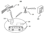
도 1은 본 발명의 실시예에 따른 버스 운행 안내 시스템의 개략도; 및
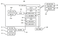
도 2는 도 1의 버스 운행 안내 시스템의 세부 구성도;이다.1 is a schematic diagram of a bus operation guidance system according to an embodiment of the present invention; And
FIG. 2 is a detailed configuration diagram of the bus operation guidance system of FIG. 1; FIG.
본 발명의 이점 및 특징, 그리고 그것들을 달성하는 방법은 첨부되는 도면과 함께 상세하게 후술되어 있는 실시예를 참조하면 명확해질 것이다. 그러나 본 발명은 이하에서 개시되는 실시예에 한정되는 것이 아니라 서로 다른 다양한 형태로 구현될 수 있으며, 단지 본 실시예는 본 발명의 개시가 완전하도록 하고, 본 발명이 속하는 기술분야에서 통상의 지식을 가진 자에게 발명의 범주를 완전하게 알려주기 위해 제공되는 것이며, 본 발명은 청구항의 범주에 의해 정의될 뿐이다. 명세서 전체에 걸쳐 동일 참조 부호는 동일 구성 요소를 지칭한다.BRIEF DESCRIPTION OF THE DRAWINGS The advantages and features of the present invention, and how to accomplish them, will become apparent by reference to the embodiments described in detail below with reference to the accompanying drawings. The present invention may, however, be embodied in many different forms and should not be construed as being limited to the embodiments set forth herein. Rather, these embodiments are provided so that this disclosure will be thorough and complete, and will fully convey the concept of the invention to those skilled in the art. Is provided to fully convey the scope of the invention to those skilled in the art, and the invention is only defined by the scope of the claims. Like reference numerals refer to like elements throughout the specification.
따라서, 몇몇 실시예에서, 잘 알려진 공정 단계들, 공지된 구조 및 공지된 기술들은 본 발명이 모호하게 해석되는 것을 피하기 위하여 구체적으로 설명되지 않는다.Thus, in some embodiments, well known process steps, known structures, and known techniques are not specifically described to avoid an undesirable interpretation of the present invention.
본 명세서에서 사용된 용어는 실시예를 설명하기 위한 것이며 본 발명을 제한하고자 하는 것은 아니다. 본 명세서에서, 단수형은 문구에서 특별히 언급하지 않는 한 복수형도 포함한다. 명세서에서 사용되는 "포함한다" 및/또는 "포함하는"은 언급된 구성요소, 단계 및/또는 동작 이외의 하나 이상의 다른 구성요소, 단계 및/또는 동작의 존재 또는 추가를 배제하지 않는 의미로 사용한다. 그리고, "및/또는"은 언급된 아이템들의 각각 및 하나 이상의 모든 조합을 포함한다.The terminology used herein is for the purpose of illustrating embodiments and is not intended to be limiting of the invention. In the present specification, the singular form includes plural forms unless otherwise specified in the specification. Used in the sense of the description does not exclude the presence or addition of one or more other components, steps and / or operations other than the stated components, steps and / or operations. do. And "and / or" include each and any combination of one or more of the mentioned items.
또한, 본 명세서에서 기술된 실시예는 본 발명의 이상적인 예시도인 사시도, 단면도, 측면도 및/또는 개략도들을 참고하여 설명될 것이다. 따라서, 제조 기술 및/또는 허용 오차 등에 의해 예시도의 형태가 변형될 수 있다. 따라서, 본 발명의 실시예는 도시된 특정 형태로 제한되는 것이 아니라 제조 공정에 따라 생성되는 형태의 변화도 포함하는 것이다. 또한, 본 발명에 도시된 각 도면에 있어서 각 구성 요소들은 설명의 편의를 고려하여 다소 확대 또는 축소되어 도시된 것일 수 있다.
In addition, the embodiments described herein will be described with reference to perspective, sectional, side view, and / or schematic views that are ideal illustrations of the present invention. Thus, the shape of the illustrations may be modified by manufacturing techniques and / or tolerances. Accordingly, the embodiments of the present invention are not limited to the specific forms shown, but also include changes in the forms that are produced according to the manufacturing process. In addition, in the drawings of the present invention, each constituent element may be somewhat enlarged or reduced in view of convenience of explanation.
이하, 첨부한 도면을 참조로 본 발명의 실시예에 따른 버스 운행 안내 시스템(100)에 대해 상세하게 설명하도록 한다.
Hereinafter, a bus
도 1에 도시한 바와 같이, 본 발명의 실시예에 따른 버스 운행 안내 시스템(100)은 버스 차량(10)에 구비된 버스 운행 단말기(110), 영상 카메라(120) 및 중앙 관리 센터(130)를 포함할 수 있으며, 버스 차량(10)에 구비된 버스 운행 단말기(110)는 GPS 위성(20)으로부터 버스 차량(10)의 위치 좌표를, 센서부(111)로부터 버스 차량(10)의 속도, 가속도, 선회각, 경사각 정보를, 영상 카메라(120)로부터 영상 정보를 수집하여, 버스 차량(10)의 운전자에게 운행 안내 정보를 제공할 수 있다.
1, a bus
버스 운행 단말기(110)는 버스 차량의 위치 좌표, 속도, 가속도, 선회각, 경사각 정보를 상용 무선통신망의 기지국(30)을 통해 원격지의 중앙 관리 센터(130)로 전송할 수 있으며, 원격지의 중앙 관리 센터(130)로부터 현재 버스 차량(10)의 위치에 대응하여 제공되는 운행 안내 정보를 수신할 수 있다.
The
영상 카메라(120)는 버스 차량(10)의 전방의 실시간 영상 또는 버스 차량의 전후좌우 방향의 실시간 영상을 수집하기 위한 것으로, 버스 운행 단말기(110)에 구비된 영상 표시부(113a)를 통해 버스 차량(10) 주변의 실시간 영상을 운전자에게 제공할 수 있다.
The
중앙 관리 센터(130)는 버스 운행 단말기(110)로부터 전송된 정보와 운행 노선의 맵 데이터를 매칭하여, 운행 노선별 3차원(3D) 맵 매칭을 실시한 후, 3차원 맵을 종합적으로 관리할 수 있으며, 필요한 경우 버스 운행 단말기(110)로 해당 버스 차량(10)의 위치에 대응하여 3차원 맵을 전송할 수 있다.
The
중앙 관리 센터(130)에서 생성되는 3차원 맵은 버스 차량(10)의 운행 노선을 나타내는 맵과 GPS 센서(111a)를 통해 얻어진 좌표 및 이 좌표에서의 차량 속도, 차량 가속도, 자이로센서의 경사도, 휠 센서의 휠 각도 변화량을 종합적으로 매칭하여, 해당 좌표에서의 경사도, 요철, 급커브 구간, 제한 속도 및 교통사고나 도로 공사 등의 돌발적으로 발생된 돌발사건이 실시간 표시될 수 있다.
The three-dimensional map generated by the
상술한 구성을 갖는 본 발명의 실시예에 따른 버스 운행 안내 시스템(100)은 도 2를 참조로 더 구체적으로 설명하기로 한다. 도 2에 도시한 바와 같이, 본 발명의 실시예에 따른 버스 운행 안내 시스템(100)은 버스 운행 단말기(110), 영상 카메라(120) 및 중앙 관리 센터(130)를 포함할 수 있다.
The bus
버스 운행 단말기(110)는 버스 차량의 노선 운행 데이터를 수집하여 중앙 관리 센터(130)로 전송하고 중앙 관리 센터(130)로부터 전송된 3차원 맵, 버스 차량(10)의 주변 영상 및 경고 음성을 표시하기 위한 것으로, 센서부(111), 버스 운행 단말기(110)와 중앙 관리 센터(130) 사이의 무선 통신을 수행하기 위한 통신부(112), 안내부(113) 및 제어부(114)를 포함할 수 있다.
The
센서부(111)는 버스 차량(10)의 위치 및 경사도를 측정하기 위한 것으로, 버스 차량의 위치를 측정하도록 GPS 위성으로부터 버스 차량(10)의 위치 좌표를 수신받는 GPS 센서(111a) 및 자이로센서(111b)를 포함할 수 있다. The
GPS 센서(111a)는 GPS 위성으로부터 수신된 항법메시지와 위성 신호를 분석하여 위성의 궤도정보, 상태, 위성시계 보정값을 계산하여 자신의 위치를 삼각측량법을 이용하여 일정 범위 내로 계산한다. The
자이로센서(111b)는 버스 차량(10)의 상하 회전 각도를 센싱하여 버스 차량(10)의 경사도를 측정하기 위한 것으로, 이와 같은 자이로센서(111b)를 통해 운행 노선의 경사도, 도로의 상태, 과속방지턱이나 요철 등이 탐지될 수 있다.
The
안내부(113)는 버스 차량(10)을 운행하는 운전자에게 영상, 3D 맵 및 음성 경고를 표시하여 안내하기 위한 것으로, 영상 표시부(113a)와 음성 표시부(113b)를 포함할 수 있다.The
영상 표시부(113a)는 영상 카메라(120)를 통해 수집된 버스 차량(10) 주변의 영상을 실시간 표시함과 동시에, 중앙 관리 센터(130)를 통해 전송되는 실시간 3D 맵 정보를 표시할 수 있다.The
한편, 영상 표시부(113a)에 표시되는 영상은 제어부(114)의 영상 매칭부(114b)에 의해 제어되는데, 본 실시예에서 영상 표시부(113a)는 실시간 주변 영상과 3D 맵을 표시하도록 LCD 디스플레이 장치를 제어할 수 있으며, 영상 표시부(113a)에서 표시되는 실시간 주변 영상은 영상 매칭부(114b)에 의해 실시간 주변 영상에 중앙 관리 센터(130)로부터 전송되는 다양한 3D 맵 정보가 매칭되어 표시될 수 있다.The image displayed on the
즉, 실시간 주변 영상과 운행 노선의 방향, 운행 노선의 경사각, 커브각, 운행 노선의 도로 상태나 전방 사고 상황 등이 실시간 주변 영상에 합성되어 영상 표시부(113a)에 표시될 수 있다.That is, the direction of the real-time surrounding image and the running route, the inclination angle of the running route, the curve angle, the road state of the running route, the forward accident situation, and the like can be combined with the real-time peripheral image and displayed on the
음성 표시부(113b)는 운전 중인 운전자에게 음성 경고 메시지를 전달하기 위한 것으로, 현재 버스 차량(10)의 속도, 전방 운행 노선의 경사각, 급커브 구간, 위험 구역 등이 음성으로 표시될 수 있다.
The
제어부(114)는 버스 운행 단말기(110)를 전체적으로 제어하기 위한 것으로, 기능적으로 구분하면 중앙 관리 센터(130)와의 통신 제어, 안내부(113)의 영상 및 음성 표시 제어 및 센서부(111) 및 버스 차량(10)의 ECU/DTG(40)로부터 전달되는 센싱 데이터를 종합하여 데이터를 생성하는 데이터 생성 제어 기능을 수행할 수 있다.The
이를 위해 제어부(114)는 데이터 생성부(114a) 및 영상 매칭부(114b)를 포함할 수 있다.For this, the
데이터 생성부(114a)는 버스 차량(10)의 운행 동안에 센싱되는 다양한 센싱 데이터를 시간 정보를 포함하여 종합하기 위한 것으로, 센서부(111)의 GPS 센서(111a)에서 전달되는 GPS 좌표값, 자이로센서(111b)에서 전달되는 현재 차량의 경사각, 버스 차량(10)의 ECU/DTG(40)로부터 전달되는 센싱 데이터를 종합할 수 있다. ECU/DTG(40)로부터 전달되는 센싱 데이터는 버스 차량(10)에 설치된 다양한 센서를 통해 수집될 수 있으며, 구체적으로는 버스 차량(10)의 속도를 센싱하는 속도 센서(41), 버스 차량(10)의 선회각을 측정하는 휠 센서(42) 및 버스 차량(10)의 가속도를 측정하는 가속도 센서(43)로부터 센싱 데이터를 수집할 수 있다.
The
영상 카메라(120)는 버스 차량(10)의 전방의 실시간 영상 또는 버스 차량의 전후좌우 방향의 실시간 영상을 수집하기 위한 것으로, 영상 카메라(120)에서 수집된 실시간 영상은 버스 운행 단말기(110)의 제어부(114)의 영상 매칭부(114b)에 전달될 수 있다. 영상 카메라(120)에서 수집된 영상은 영상 표시부(113a)를 통해 직접 표시될 수 있고, 또는 영상 매칭부(114b)에서 중앙 관리 센터(130)로부터 전송된 3D 맵 데이터와 매칭되어 3D 맵 데이터를 포함한 영상이 표시될 수 있다.
The
중앙 관리 센터(130)는 버스 운행 단말기(110)로부터 전송된 정보와 운행 노선의 맵 데이터를 매칭하여, 운행 노선별 3차원(3D) 맵 매칭을 실시한 후, 3차원 맵을 생성하여 종합적으로 관리할 수 있으며, 필요한 경우 버스 운행 단말기(110)로 해당 버스 차량(10)의 위치에 대응하여 3차원 맵을 전송할 수 있다. 이를 위해 중앙 관리 센터(130)는 맵 매칭부(131) 및 맵 데이터베이스(132)를 포함할 수 있다.
The
맵 매칭부(131)는 버스 운행 단말기(110)로부터 전송되는 버스 차량(10)의 위치 좌표, 속도, 가속도, 버스 차량(10)의 경사 및 고도 정보를 맵 데이터베이스(132)에 저장된 운행 노선 맵 데이터와 매칭하여 3D 맵 데이터를 생성할 수 있다. 맵 매칭부(131)에서 생성되는 3차원 맵은 버스 차량(10)의 운행 노선을 나타내는 맵과 GPS 센서(111a)를 통해 얻어진 좌표 및 이 좌표에서의 차량 속도, 차량 가속도, 자이로센서의 경사도, 휠 센서의 휠 각도 변화량을 종합적으로 매칭하여, 해당 좌표에서의 경사도, 요철, 급커브 구간, 제한 속도 및 교통사고나 도로 공사 등의 돌발적으로 발생된 돌발사건이 실시간 표시될 수 있다.The
맵 데이터베이스(132)는 버스 차량(10)의 운행 노선 맵 데이터 및 생성된 3D 맵 데이터를 저장할 수 있으며, 중앙 관리 센터(130)에서 버스 운행 단말기(110)의 현재 위치 좌표에 대응하는 3D 맵 데이터를 버스 운행 단말기(110)에 전송할 경우, 위치 좌표에 대응하는 3D 맵 데이터를 검색하여 전송할 수 있다.
The
이상, 본 발명의 실시예에 대하여 설명하였으나, 해당 기술 분야에서 통상의 지식을 가진 자라면 특허청구범위에 기재된 본 발명의 사상으로부터 벗어나지 않는 범위 내에서, 구성 요소의 부가, 변경, 삭제 또는 추가 등에 의해 본 발명을 다양하게 수정 및 변경시킬 수 있을 것이며, 이 또한 본 발명의 권리범위 내에 포함된다고 할 것이다.
While the present invention has been particularly shown and described with reference to exemplary embodiments thereof, it is to be understood that the invention is not limited to the disclosed embodiments, but, on the contrary, It will be understood by those skilled in the art that various changes in form and details may be made therein without departing from the spirit and scope of the invention as defined by the appended claims.
10 : 버스 차량
20 : GPS 위성
30 : 기지국
40 : ECU/DTG
100 : 버스 운행 안내 시스템10: Bus car
20: GPS satellite
30: base station
40: ECU / DTG
100: Bus service guide system
Claims (8)
상기 버스 운행 단말기로부터 전송되는 센싱 데이터와 맵 데이터를 매칭하여 상기 버스 차량의 상기 GPS 좌표별 3D 맵 데이터를 생성하여 관리하는 중앙 관리 센터;를 포함하는 버스 운행 안내 시스템.
A bus operating terminal for receiving sensing data including time information by receiving GPS coordinates from the GPS satellites, speed of the bus vehicle from the bus ECU / DTG, acceleration, turning angle information, and tilt information of the bus vehicle from the gyro sensor; And
And a central management center for generating and managing 3D map data for each of the GPS coordinates of the bus vehicle by matching the sensing data transmitted from the bus operating terminal with the map data.
상기 버스 운행 단말기는,
상기 중앙 관리 센터로부터 전송된 3D 맵 데이터를 표시하여 안내하며, 상기 3D 맵 데이터는 시각 및 음성으로 표시되는 것을 특징으로 하는 버스 운행 안내 시스템.
The method according to claim 1,
The bus operating terminal,
And displays and guides the 3D map data transmitted from the central management center, and the 3D map data is displayed in time and voice.
상기 버스 운행 안내 시스템은, 상기 버스 차량의 속도, 가속도 및 선회각의 정보를 상기 버스 차량에 구비된 ECU/DTG로부터 수집하고, 상기 버스 차량의 주변 영상을 상기 버스 차량에 구비된 영상 카메라로부터 수집하는 것을 특징으로 하는 버스 운행 안내 시스템.
The method according to claim 1,
The bus navigation guidance system collects information on the speed, acceleration, and turning angle of the bus vehicle from an ECU / DTG provided in the bus vehicle, and collects peripheral images of the bus vehicle from an image camera provided in the bus vehicle And the bus operation guidance system.
상기 버스 운행 단말기는,
상기 버스 차량의 경사도 정보를 수집하는 자이로센서 및 GPS 좌표를 수집하는 GPS 센서를 포함한 센서부; 상기 영상 카메라의 영상 및 상기 3D 맵 데이터를 시각적으로 표시하는 영상 표시부 및 음성으로 표시하는 음성 표시부를 포함한 안내부; 상기 센싱 데이터를 상기 중앙 관리 센터로 무선 송신하고 상기 3D 맵 데이터를 무선 수신하는 통신부; 및 상기 시간 정보를 포함한 센싱 데이터를 생성하는 데이터 생성부 및 상기 영상 카메라의 영상과 상기 3D 맵 데이터를 매칭하여 합성하는 영상 매칭부를 포함하는 제어부;를 포함하는 것을 특징으로 하는 버스 운행 안내 시스템.
The method according to claim 1,
The bus operating terminal,
A sensor unit including a gyro sensor for collecting gradient information of the bus vehicle and a GPS sensor for collecting GPS coordinates; An image display unit for visually displaying the image of the image camera and the 3D map data, and a voice display unit for displaying the image by voice; A communication unit wirelessly transmitting the sensing data to the central management center and wirelessly receiving the 3D map data; And a controller for generating sensing data including the time information and an image matching unit for matching and combining the image of the image camera and the 3D map data.
상기 중앙 관리 센터는,
지도 정보 및 3D 맵 데이터를 저장하는 맵 데이터베이스; 및 상기 버스 운행 단말기로부터 전송된 센싱 데이터와 상기 지도 정보를 매칭하여 상기 3D 맵 데이터를 생성하는 맵 매칭부;를 포함하는 것을 특징으로 하는 버스 운행 안내 시스템.
The method according to claim 1,
The central management center,
A map database storing map information and 3D map data; And a map matching unit for matching the sensing data transmitted from the bus operating terminal with the map information to generate the 3D map data.
상기 안내부는 상기 영상 카메라의 영상 및 상기 3D 맵 데이터를 동시에 표시하는 것을 특징으로 하는 버스 운행 안내 시스템.
The method according to claim 1,
Wherein the guide unit simultaneously displays the image of the image camera and the 3D map data.
상기 안내부는 상기 영상 카메라의 영상과 상기 3D 맵 데이터가 합성된 영상을 표시하는 것을 특징으로 하는 버스 운행 안내 시스템.
The method according to claim 1,
Wherein the guide unit displays an image obtained by combining the image of the image camera and the 3D map data.
상기 3D 맵 데이터는 상기 버스 차량의 운행 노선의 경사도 또는 고도 정보, 과속 방지턱, 급커브 구역과 같은 도로 상태 정보를 포함하는 것을 특징으로 하는 버스 운행 안내 시스템.
The method according to claim 1,
Wherein the 3D map data includes road state information such as an inclination or altitude information of a driving route of the bus vehicle, a speed limit bass, and a steep curve area.
Priority Applications (1)
| Application Number | Priority Date | Filing Date | Title |
|---|---|---|---|
| KR1020140187867A KR101647626B1 (en) | 2014-12-24 | 2014-12-24 | Bus Operation Guiding System |
Applications Claiming Priority (1)
| Application Number | Priority Date | Filing Date | Title |
|---|---|---|---|
| KR1020140187867A KR101647626B1 (en) | 2014-12-24 | 2014-12-24 | Bus Operation Guiding System |
Publications (2)
| Publication Number | Publication Date |
|---|---|
| KR20160077678A true KR20160077678A (en) | 2016-07-04 |
| KR101647626B1 KR101647626B1 (en) | 2016-08-11 |
Family
ID=56501097
Family Applications (1)
| Application Number | Title | Priority Date | Filing Date |
|---|---|---|---|
| KR1020140187867A Active KR101647626B1 (en) | 2014-12-24 | 2014-12-24 | Bus Operation Guiding System |
Country Status (1)
| Country | Link |
|---|---|
| KR (1) | KR101647626B1 (en) |
Cited By (5)
| Publication number | Priority date | Publication date | Assignee | Title |
|---|---|---|---|---|
| CN107871399A (en) * | 2016-12-27 | 2018-04-03 | 珠海市杰理科技股份有限公司 | Vehicle automatic driving system and method |
| CN110517548A (en) * | 2019-08-26 | 2019-11-29 | 北京星际元会展有限公司 | Satellite positioning experience apparatus |
| CN112269845A (en) * | 2020-10-22 | 2021-01-26 | 东南大学 | Method for quickly matching electronic road map and bus route facing to different source data |
| KR102530581B1 (en) * | 2021-12-03 | 2023-05-10 | 아주대학교산학협력단 | Apparatus for hydrogen electric vehicle monitoring for predict abnormal or dangerous situations and method thereof |
| KR20240155587A (en) * | 2023-04-20 | 2024-10-29 | (주) 더아이엠씨 | Analysis Method for Risky Bus Driving Behavior Based on Real-Time Location Information |
Citations (5)
| Publication number | Priority date | Publication date | Assignee | Title |
|---|---|---|---|---|
| JPH1089978A (en) * | 1996-09-19 | 1998-04-10 | Toshiba Corp | Navigation apparatus and video data display method in the same |
| JP2002133591A (en) * | 2000-10-27 | 2002-05-10 | Denso Corp | Vehicle operation system and vehicle operation method |
| KR100941171B1 (en) * | 2009-04-06 | 2010-02-10 | (주)경봉 | Apparatus for and method of displaying arrival time of bus in bus information system |
| JP2010238021A (en) * | 2009-03-31 | 2010-10-21 | Zenrin Datacom Co Ltd | Vehicle operation management system and operation management method, vehicle terminal, and operation management device |
| KR20110027873A (en) | 2009-09-11 | 2011-03-17 | 강동훈 | Bus operation information system equipped with transportation card charging function |
-
2014
- 2014-12-24 KR KR1020140187867A patent/KR101647626B1/en active Active
Patent Citations (5)
| Publication number | Priority date | Publication date | Assignee | Title |
|---|---|---|---|---|
| JPH1089978A (en) * | 1996-09-19 | 1998-04-10 | Toshiba Corp | Navigation apparatus and video data display method in the same |
| JP2002133591A (en) * | 2000-10-27 | 2002-05-10 | Denso Corp | Vehicle operation system and vehicle operation method |
| JP2010238021A (en) * | 2009-03-31 | 2010-10-21 | Zenrin Datacom Co Ltd | Vehicle operation management system and operation management method, vehicle terminal, and operation management device |
| KR100941171B1 (en) * | 2009-04-06 | 2010-02-10 | (주)경봉 | Apparatus for and method of displaying arrival time of bus in bus information system |
| KR20110027873A (en) | 2009-09-11 | 2011-03-17 | 강동훈 | Bus operation information system equipped with transportation card charging function |
Cited By (6)
| Publication number | Priority date | Publication date | Assignee | Title |
|---|---|---|---|---|
| CN107871399A (en) * | 2016-12-27 | 2018-04-03 | 珠海市杰理科技股份有限公司 | Vehicle automatic driving system and method |
| CN110517548A (en) * | 2019-08-26 | 2019-11-29 | 北京星际元会展有限公司 | Satellite positioning experience apparatus |
| CN112269845A (en) * | 2020-10-22 | 2021-01-26 | 东南大学 | Method for quickly matching electronic road map and bus route facing to different source data |
| CN112269845B (en) * | 2020-10-22 | 2021-06-22 | 东南大学 | A fast matching method of electronic road map and bus route for heterogeneous data |
| KR102530581B1 (en) * | 2021-12-03 | 2023-05-10 | 아주대학교산학협력단 | Apparatus for hydrogen electric vehicle monitoring for predict abnormal or dangerous situations and method thereof |
| KR20240155587A (en) * | 2023-04-20 | 2024-10-29 | (주) 더아이엠씨 | Analysis Method for Risky Bus Driving Behavior Based on Real-Time Location Information |
Also Published As
| Publication number | Publication date |
|---|---|
| KR101647626B1 (en) | 2016-08-11 |
Similar Documents
| Publication | Publication Date | Title |
|---|---|---|
| US10120378B2 (en) | Vehicle automated driving system | |
| US10005391B2 (en) | Information presentation system | |
| US10331139B2 (en) | Navigation device for autonomously driving vehicle | |
| US20230304821A1 (en) | Digital signage platform providing device, operating method thereof, and system including digital signage platform providing device | |
| KR102331025B1 (en) | Image information acquisition device, vehicle and method for controlling thereof | |
| JP7620440B2 (en) | Autonomous Driving Assistance System | |
| US20190193738A1 (en) | Vehicle and Control Method Thereof | |
| US9638530B2 (en) | System and method for distribution of 3D sound | |
| JP5898539B2 (en) | Vehicle driving support system | |
| KR101979276B1 (en) | User interface apparatus for vehicle and Vehicle | |
| CN105806358B (en) | Method and device for driving prompt | |
| JP5327025B2 (en) | Vehicle travel guidance device, vehicle travel guidance method, and computer program | |
| US12233714B2 (en) | Information processing apparatus, information processing method, and mobile body apparatus | |
| JP2005098853A (en) | Map data updating method and map data updating apparatus | |
| KR101647626B1 (en) | Bus Operation Guiding System | |
| KR101979277B1 (en) | User interface apparatus for vehicle and Vehicle | |
| JP2015191256A (en) | Risk degree determination device, risk degree determination method and risk degree determination program | |
| JP2013124957A (en) | Navigation system using portable information terminal | |
| CN102445210A (en) | Navigation system and method for target navigation of motor vehicle | |
| KR101281629B1 (en) | Driving guidance system using sensors | |
| CN103292785B (en) | Car-mounted device | |
| US11193784B2 (en) | End of trip sequence | |
| CN116630577B (en) | AR information display method, vehicle and device under real-time moving live-action | |
| JP2017182418A (en) | Driving assisting device and driving support system | |
| CN113218410A (en) | System and method for vehicle navigation using terrain text recognition |
Legal Events
| Date | Code | Title | Description |
|---|---|---|---|
| A201 | Request for examination | ||
| PA0109 | Patent application |
St.27 status event code: A-0-1-A10-A12-nap-PA0109 |
|
| PA0201 | Request for examination |
St.27 status event code: A-1-2-D10-D11-exm-PA0201 |
|
| PN2301 | Change of applicant |
St.27 status event code: A-3-3-R10-R11-asn-PN2301 |
|
| R19-X000 | Request for party data change rejected |
St.27 status event code: A-3-3-R10-R19-oth-X000 |
|
| N231 | Notification of change of applicant | ||
| PN2301 | Change of applicant |
St.27 status event code: A-3-3-R10-R13-asn-PN2301 St.27 status event code: A-3-3-R10-R11-asn-PN2301 |
|
| R17-X000 | Change to representative recorded |
St.27 status event code: A-3-3-R10-R17-oth-X000 |
|
| E902 | Notification of reason for refusal | ||
| PE0902 | Notice of grounds for rejection |
St.27 status event code: A-1-2-D10-D21-exm-PE0902 |
|
| E13-X000 | Pre-grant limitation requested |
St.27 status event code: A-2-3-E10-E13-lim-X000 |
|
| P11-X000 | Amendment of application requested |
St.27 status event code: A-2-2-P10-P11-nap-X000 |
|
| P13-X000 | Application amended |
St.27 status event code: A-2-2-P10-P13-nap-X000 |
|
| E701 | Decision to grant or registration of patent right | ||
| PE0701 | Decision of registration |
St.27 status event code: A-1-2-D10-D22-exm-PE0701 |
|
| PG1501 | Laying open of application |
St.27 status event code: A-1-1-Q10-Q12-nap-PG1501 |
|
| P22-X000 | Classification modified |
St.27 status event code: A-2-2-P10-P22-nap-X000 |
|
| GRNT | Written decision to grant | ||
| PR0701 | Registration of establishment |
St.27 status event code: A-2-4-F10-F11-exm-PR0701 |
|
| PR1002 | Payment of registration fee |
St.27 status event code: A-2-2-U10-U11-oth-PR1002 Fee payment year number: 1 |
|
| PG1601 | Publication of registration |
St.27 status event code: A-4-4-Q10-Q13-nap-PG1601 |
|
| FPAY | Annual fee payment |
Payment date: 20190703 Year of fee payment: 4 |
|
| PR1001 | Payment of annual fee |
St.27 status event code: A-4-4-U10-U11-oth-PR1001 Fee payment year number: 4 |
|
| PR1001 | Payment of annual fee |
St.27 status event code: A-4-4-U10-U11-oth-PR1001 Fee payment year number: 5 |
|
| PR1001 | Payment of annual fee |
St.27 status event code: A-4-4-U10-U11-oth-PR1001 Fee payment year number: 6 |
|
| PR1001 | Payment of annual fee |
St.27 status event code: A-4-4-U10-U11-oth-PR1001 Fee payment year number: 7 |
|
| P22-X000 | Classification modified |
St.27 status event code: A-4-4-P10-P22-nap-X000 |
|
| P22-X000 | Classification modified |
St.27 status event code: A-4-4-P10-P22-nap-X000 |
|
| P14-X000 | Amendment of ip right document requested |
St.27 status event code: A-5-5-P10-P14-nap-X000 |
|
| R18-X000 | Changes to party contact information recorded |
St.27 status event code: A-5-5-R10-R18-oth-X000 |
|
| P14-X000 | Amendment of ip right document requested |
St.27 status event code: A-5-5-P10-P14-nap-X000 |
|
| R18-X000 | Changes to party contact information recorded |
St.27 status event code: A-5-5-R10-R18-oth-X000 |
|
| PR1001 | Payment of annual fee |
St.27 status event code: A-4-4-U10-U11-oth-PR1001 Fee payment year number: 8 |
|
| P14-X000 | Amendment of ip right document requested |
St.27 status event code: A-5-5-P10-P14-nap-X000 |
|
| P22-X000 | Classification modified |
St.27 status event code: A-4-4-P10-P22-nap-X000 |
|
| PR1001 | Payment of annual fee |
St.27 status event code: A-4-4-U10-U11-oth-PR1001 Fee payment year number: 9 |
|
| P22-X000 | Classification modified |
St.27 status event code: A-4-4-P10-P22-nap-X000 |
|
| P22-X000 | Classification modified |
St.27 status event code: A-4-4-P10-P22-nap-X000 |
|
| PR1001 | Payment of annual fee |
St.27 status event code: A-4-4-U10-U11-oth-PR1001 Fee payment year number: 10 |
|
| P14 | Amendment of ip right document requested |
Free format text: ST27 STATUS EVENT CODE: A-5-5-P10-P14-NAP-X000 (AS PROVIDED BY THE NATIONAL OFFICE) |
|
| P14-X000 | Amendment of ip right document requested |
St.27 status event code: A-5-5-P10-P14-nap-X000 |