KR20200020969A - 지도 데이터, 레이저들 및 카메라들로부터의 요 에러 결정 - Google Patents
지도 데이터, 레이저들 및 카메라들로부터의 요 에러 결정 Download PDFInfo
- Publication number
- KR20200020969A KR20200020969A KR1020207004418A KR20207004418A KR20200020969A KR 20200020969 A KR20200020969 A KR 20200020969A KR 1020207004418 A KR1020207004418 A KR 1020207004418A KR 20207004418 A KR20207004418 A KR 20207004418A KR 20200020969 A KR20200020969 A KR 20200020969A
- Authority
- KR
- South Korea
- Prior art keywords
- image
- data
- vehicle
- camera
- yaw
- Prior art date
- Legal status (The legal status is an assumption and is not a legal conclusion. Google has not performed a legal analysis and makes no representation as to the accuracy of the status listed.)
- Granted
Links
Images





Classifications
-
- G—PHYSICS
- G01—MEASURING; TESTING
- G01S—RADIO DIRECTION-FINDING; RADIO NAVIGATION; DETERMINING DISTANCE OR VELOCITY BY USE OF RADIO WAVES; LOCATING OR PRESENCE-DETECTING BY USE OF THE REFLECTION OR RERADIATION OF RADIO WAVES; ANALOGOUS ARRANGEMENTS USING OTHER WAVES
- G01S17/00—Systems using the reflection or reradiation of electromagnetic waves other than radio waves, e.g. lidar systems
- G01S17/88—Lidar systems specially adapted for specific applications
- G01S17/89—Lidar systems specially adapted for specific applications for mapping or imaging
-
- G—PHYSICS
- G01—MEASURING; TESTING
- G01S—RADIO DIRECTION-FINDING; RADIO NAVIGATION; DETERMINING DISTANCE OR VELOCITY BY USE OF RADIO WAVES; LOCATING OR PRESENCE-DETECTING BY USE OF THE REFLECTION OR RERADIATION OF RADIO WAVES; ANALOGOUS ARRANGEMENTS USING OTHER WAVES
- G01S7/00—Details of systems according to groups G01S13/00, G01S15/00, G01S17/00
- G01S7/48—Details of systems according to groups G01S13/00, G01S15/00, G01S17/00 of systems according to group G01S17/00
- G01S7/4808—Evaluating distance, position or velocity data
-
- G—PHYSICS
- G01—MEASURING; TESTING
- G01S—RADIO DIRECTION-FINDING; RADIO NAVIGATION; DETERMINING DISTANCE OR VELOCITY BY USE OF RADIO WAVES; LOCATING OR PRESENCE-DETECTING BY USE OF THE REFLECTION OR RERADIATION OF RADIO WAVES; ANALOGOUS ARRANGEMENTS USING OTHER WAVES
- G01S7/00—Details of systems according to groups G01S13/00, G01S15/00, G01S17/00
- G01S7/48—Details of systems according to groups G01S13/00, G01S15/00, G01S17/00 of systems according to group G01S17/00
- G01S7/497—Means for monitoring or calibrating
-
- G—PHYSICS
- G05—CONTROLLING; REGULATING
- G05D—SYSTEMS FOR CONTROLLING OR REGULATING NON-ELECTRIC VARIABLES
- G05D1/00—Control of position, course, altitude or attitude of land, water, air or space vehicles, e.g. using automatic pilots
- G05D1/02—Control of position or course in two dimensions
- G05D1/021—Control of position or course in two dimensions specially adapted to land vehicles
- G05D1/0231—Control of position or course in two dimensions specially adapted to land vehicles using optical position detecting means
- G05D1/0238—Control of position or course in two dimensions specially adapted to land vehicles using optical position detecting means using obstacle or wall sensors
- G05D1/024—Control of position or course in two dimensions specially adapted to land vehicles using optical position detecting means using obstacle or wall sensors in combination with a laser
-
- G—PHYSICS
- G06—COMPUTING OR CALCULATING; COUNTING
- G06T—IMAGE DATA PROCESSING OR GENERATION, IN GENERAL
- G06T7/00—Image analysis
- G06T7/0002—Inspection of images, e.g. flaw detection
- G06T7/0004—Industrial image inspection
- G06T7/001—Industrial image inspection using an image reference approach
-
- G—PHYSICS
- G06—COMPUTING OR CALCULATING; COUNTING
- G06T—IMAGE DATA PROCESSING OR GENERATION, IN GENERAL
- G06T7/00—Image analysis
- G06T7/70—Determining position or orientation of objects or cameras
-
- G—PHYSICS
- G06—COMPUTING OR CALCULATING; COUNTING
- G06V—IMAGE OR VIDEO RECOGNITION OR UNDERSTANDING
- G06V10/00—Arrangements for image or video recognition or understanding
- G06V10/70—Arrangements for image or video recognition or understanding using pattern recognition or machine learning
- G06V10/74—Image or video pattern matching; Proximity measures in feature spaces
- G06V10/75—Organisation of the matching processes, e.g. simultaneous or sequential comparisons of image or video features; Coarse-fine approaches, e.g. multi-scale approaches; using context analysis; Selection of dictionaries
- G06V10/751—Comparing pixel values or logical combinations thereof, or feature values having positional relevance, e.g. template matching
-
- G—PHYSICS
- G06—COMPUTING OR CALCULATING; COUNTING
- G06V—IMAGE OR VIDEO RECOGNITION OR UNDERSTANDING
- G06V20/00—Scenes; Scene-specific elements
- G06V20/50—Context or environment of the image
- G06V20/56—Context or environment of the image exterior to a vehicle by using sensors mounted on the vehicle
-
- H—ELECTRICITY
- H04—ELECTRIC COMMUNICATION TECHNIQUE
- H04N—PICTORIAL COMMUNICATION, e.g. TELEVISION
- H04N7/00—Television systems
- H04N7/18—Closed-circuit television [CCTV] systems, i.e. systems in which the video signal is not broadcast
- H04N7/183—Closed-circuit television [CCTV] systems, i.e. systems in which the video signal is not broadcast for receiving images from a single remote source
- H04N7/185—Closed-circuit television [CCTV] systems, i.e. systems in which the video signal is not broadcast for receiving images from a single remote source from a mobile camera, e.g. for remote control
Landscapes
- Engineering & Computer Science (AREA)
- Physics & Mathematics (AREA)
- General Physics & Mathematics (AREA)
- Theoretical Computer Science (AREA)
- Radar, Positioning & Navigation (AREA)
- Remote Sensing (AREA)
- Computer Networks & Wireless Communication (AREA)
- Computer Vision & Pattern Recognition (AREA)
- Multimedia (AREA)
- Electromagnetism (AREA)
- Medical Informatics (AREA)
- Databases & Information Systems (AREA)
- Evolutionary Computation (AREA)
- General Health & Medical Sciences (AREA)
- Computing Systems (AREA)
- Software Systems (AREA)
- Artificial Intelligence (AREA)
- Health & Medical Sciences (AREA)
- Quality & Reliability (AREA)
- Signal Processing (AREA)
- Traffic Control Systems (AREA)
- Optical Radar Systems And Details Thereof (AREA)
- Optics & Photonics (AREA)
- Aviation & Aerospace Engineering (AREA)
- Automation & Control Theory (AREA)
- Instructional Devices (AREA)
- Image Analysis (AREA)
- Navigation (AREA)
Abstract
Description
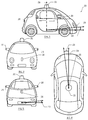
도 2는 예시적인 실시예에 따른 차량을 예시한다.
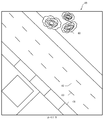
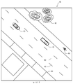
도 3a는 예시적인 실시예에 따른 탑-다운 지도 이미지를 예시한다.
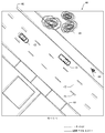
도 3b는 예시적인 실시예에 따른 탑-다운 카메라 이미지를 예시한다.
도 3c는 예시적인 실시예에 따른 탑-다운 집성 이미지(top-down aggregate image)를 예시한다.
도 3d는 예시적인 실시예에 따른 탑-다운 집성 이미지를 예시한다.
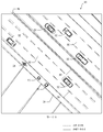
도 4a는 예시적인 실시예에 따른 탑-다운 지도 이미지를 예시한다.
도 4b는 예시적인 실시예에 따른 탑-다운 LIDAR 이미지를 예시한다.
도 4c는 예시적인 실시예에 따른 탑-다운 집성 이미지를 예시한다.
도 4d는 예시적인 실시예에 따른 탑-다운 집성 이미지를 예시한다.
도 5a는 예시적인 실시예에 따른 전방 지도 이미지를 예시한다.
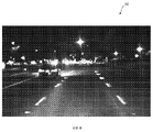
도 5b는 예시적인 실시예에 따른 전방 카메라 이미지를 예시한다.
도 5c는 예시적인 실시예에 따른 전방 집성 이미지를 예시한다.
도 5d는 예시적인 실시예에 따른 전방 집성 이미지를 예시한다.
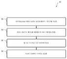
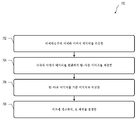
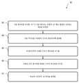
도 6은 예시적인 실시예에 따른 방법을 예시한다.
도 7은 예시적인 실시예에 따른 방법을 예시한다.
도 8은 예시적인 실시예에 따른 방법을 예시한다.
Claims (20)
- 방법으로서,
라이다(light detection and ranging)(LIDAR) 디바이스로부터 포인트 클라우드 데이터를 수신하는 단계;
상기 포인트 클라우드 데이터를 변환하여 탑-다운 이미지(top-down image)를 제공하는 단계;
상기 탑-다운 이미지를 기준 이미지(reference image)와 비교하는 단계; 및
상기 비교에 기초하여, 요 에러(yaw error)를 결정하는 단계
를 포함하는 방법. - 제1항에 있어서, 상기 포인트 클라우드 데이터는 차량 주변 환경에서의 객체들을 나타내는 정보를 포함하는 방법.
- 제2항에 있어서, 상기 탑-다운 이미지는 상기 차량 주변 환경의 평탄화된 2차원 이미지를 포함하는 방법.
- 제1항에 있어서,
상기 결정된 요 에러에 기초하여 차량의 포즈 추정기에 조정 신호를 제공하는 단계를 추가로 포함하는 방법. - 제4항에 있어서,
상기 포즈 추정기에 의해, 상기 차량의 요 방위를 결정하는 단계; 및
상기 조정 신호 및 상기 결정된 요 방위에 기초하여 개선된 요 방위를 결정하는 단계
를 추가로 포함하는 방법. - 제1항에 있어서, 상기 기준 이미지는 지도 데이터의 적어도 일부를 포함하는 방법.
- 제1항에 있어서, 상기 기준 이미지는 하나 이상의 이전 카메라 이미지, LIDAR 포인트 클라우드, RADAR 데이터, 위성 이미지 또는 다른 오버헤드 이미지 중 적어도 하나의 적어도 일부를 포함하는 방법.
- 방법으로서,
카메라로부터 카메라 이미지 데이터를 수신하는 단계;
상기 카메라 이미지 데이터를 변환하여 탑-다운 이미지를 제공하는 단계;
상기 탑-다운 이미지를 기준 이미지와 비교하는 단계; 및
상기 비교에 기초하여, 요 에러를 결정하는 단계
를 포함하는 방법. - 제8항에 있어서, 상기 카메라 이미지 데이터는 차량 주변 환경을 나타내는 정보를 포함하는 방법.
- 제8항에 있어서, 상기 탑-다운 이미지는 차량 주변 환경의 평탄화된 2차원 이미지를 포함하는 방법.
- 제8항에 있어서,
상기 결정된 요 에러에 기초하여 차량의 포즈 추정기에 조정 신호를 제공하는 단계를 추가로 포함하는 방법. - 제11항에 있어서,
상기 포즈 추정기에 의해, 상기 차량의 요 방위를 결정하는 단계; 및
상기 조정 신호 및 상기 결정된 요 방위에 기초하여 개선된 요 방위를 결정하는 단계
를 추가로 포함하는 방법. - 제8항에 있어서, 상기 기준 이미지는 지도 데이터의 적어도 일부를 포함하는 방법.
- 제8항에 있어서, 상기 기준 이미지는 하나 이상의 이전 카메라 이미지, LIDAR 포인트 클라우드, RADAR 데이터, 위성 이미지 또는 다른 오버헤드 이미지 중 적어도 하나의 적어도 일부를 포함하는 방법.
- 방법으로서,
기준 데이터를 수신하는 단계 - 상기 기준 데이터는 장면의 오버헤드 관점(overhead perspective)을 나타내는 정보를 포함함-;
상기 기준 데이터를 카메라의 시야에 대응하도록 변환하는 단계;
상기 카메라로부터 카메라 이미지 데이터를 수신하는 단계;
상기 변환된 기준 데이터를 상기 카메라 이미지 데이터와 비교하는 단계; 및
상기 비교에 기초하여, 요 에러를 결정하는 단계
를 포함하는 방법. - 제15항에 있어서, 상기 카메라 이미지 데이터는 차량 주변 환경의 평탄화된 2차원 이미지를 포함하는 방법.
- 제15항에 있어서,
상기 결정된 요 에러에 기초하여 차량의 포즈 추정기에 조정 신호를 제공하는 단계를 추가로 포함하는 방법. - 제15항에 있어서, 상기 카메라 이미지 데이터는 상기 변환된 기준 데이터의 적어도 일부에 대응하는 방법.
- 제15항에 있어서, 상기 기준 데이터는 하나 이상의 이전 카메라 이미지, LIDAR 포인트 클라우드, RADAR 데이터, 위성 이미지 또는 다른 오버헤드 이미지 중 적어도 하나의 적어도 일부를 포함하는 방법.
- 제15항에 있어서, 상기 기준 데이터 또는 상기 카메라 이미지 데이터 중 적어도 하나는 이미지 차이 알고리즘, 이미지 호모그래피 알고리즘 또는 이미지 교정 알고리즘(image rectification algorithm) 중 적어도 하나를 사용하여 프로세싱되는 방법.
Applications Claiming Priority (3)
| Application Number | Priority Date | Filing Date | Title |
|---|---|---|---|
| US15/658,800 US10670725B2 (en) | 2017-07-25 | 2017-07-25 | Determining yaw error from map data, lasers, and cameras |
| US15/658,800 | 2017-07-25 | ||
| PCT/US2018/041465 WO2019022948A1 (en) | 2017-07-25 | 2018-07-10 | DETERMINING A LACET ERROR FROM MAP DATA, LASERS, AND CAMERAS |
Publications (2)
| Publication Number | Publication Date |
|---|---|
| KR20200020969A true KR20200020969A (ko) | 2020-02-26 |
| KR102319191B1 KR102319191B1 (ko) | 2021-10-29 |
Family
ID=65038209
Family Applications (1)
| Application Number | Title | Priority Date | Filing Date |
|---|---|---|---|
| KR1020207004418A Active KR102319191B1 (ko) | 2017-07-25 | 2018-07-10 | 지도 데이터, 레이저들 및 카메라들로부터의 요 에러 결정 |
Country Status (6)
| Country | Link |
|---|---|
| US (3) | US10670725B2 (ko) |
| EP (1) | EP3658957A4 (ko) |
| JP (2) | JP6901625B2 (ko) |
| KR (1) | KR102319191B1 (ko) |
| CN (1) | CN110945379A (ko) |
| WO (1) | WO2019022948A1 (ko) |
Families Citing this family (48)
| Publication number | Priority date | Publication date | Assignee | Title |
|---|---|---|---|---|
| PL230192B1 (pl) * | 2016-09-28 | 2018-10-31 | Lipik Jacek Gama | Skaner zwłaszcza do starodruków oraz sposób skanowania |
| JP6638695B2 (ja) * | 2017-05-18 | 2020-01-29 | トヨタ自動車株式会社 | 自動運転システム |
| AU2018299284A1 (en) * | 2017-07-14 | 2019-10-24 | Komatsu Ltd. | Topographic information transmission device, construction management system, and topographic information transmission method |
| DE102017117545A1 (de) * | 2017-08-02 | 2019-02-07 | Jungheinrich Aktiengesellschaft | Verfahren zur Überwachung des Fahrwegs eines Flurförderzeuges sowie ein Flurförderzeug |
| US10794710B1 (en) | 2017-09-08 | 2020-10-06 | Perceptin Shenzhen Limited | High-precision multi-layer visual and semantic map by autonomous units |
| DE102017217065A1 (de) * | 2017-09-26 | 2019-03-28 | Robert Bosch Gmbh | Verfahren und System zum Kartieren und Lokalisieren eines Fahrzeugs basierend auf Radarmessungen |
| US11237269B2 (en) * | 2018-04-26 | 2022-02-01 | Ford Global Technologies, Llc | Localization technique |
| US10551485B1 (en) | 2018-08-06 | 2020-02-04 | Luminar Technologies, Inc. | Fitting points to a surface |
| US10698408B2 (en) | 2018-08-30 | 2020-06-30 | Pony Ai Inc. | Distributed sensing for vehicle navigation |
| US11346950B2 (en) * | 2018-11-19 | 2022-05-31 | Huawei Technologies Co., Ltd. | System, device and method of generating a high resolution and high accuracy point cloud |
| US11577647B2 (en) * | 2018-12-27 | 2023-02-14 | Continental Autonomous Mobility US, LLC | Surround view by drones |
| JP7315723B2 (ja) * | 2019-06-17 | 2023-07-26 | 華為技術有限公司 | 車両姿勢認識方法及び関連装置 |
| US10613203B1 (en) * | 2019-07-01 | 2020-04-07 | Velodyne Lidar, Inc. | Interference mitigation for light detection and ranging |
| CN112639882B (zh) * | 2019-09-12 | 2021-12-14 | 华为技术有限公司 | 定位方法、装置及系统 |
| CN112578390A (zh) * | 2019-09-29 | 2021-03-30 | 睿镞科技(北京)有限责任公司 | 激光雷达及生成激光点云数据的方法 |
| CN110705577B (zh) * | 2019-09-29 | 2022-06-07 | 武汉中海庭数据技术有限公司 | 一种激光点云车道线提取方法 |
| DE102019215026A1 (de) * | 2019-09-30 | 2021-04-01 | Robert Bosch Gmbh | Verfahren und Vorrichtung zum Ermitteln eines hochgenauen Schätzwerts einer Gierrate zum Steuern eines Fahrzeugs |
| CN110686677B (zh) * | 2019-10-10 | 2022-12-13 | 东北大学 | 一种基于几何信息的全局定位方法 |
| US11262759B2 (en) | 2019-10-16 | 2022-03-01 | Huawei Technologies Co., Ltd. | Method and system for localization of an autonomous vehicle in real time |
| EP4070130A4 (en) * | 2019-12-04 | 2023-12-27 | Waymo LLC | EFFICIENT ALGORITHM FOR PROJECTING WORLD POINTS ONTO A ROLLER SHUTTER IMAGE |
| CN113312435B (zh) * | 2020-02-27 | 2023-06-06 | 武汉四维图新科技有限公司 | 高精度地图更新方法和设备 |
| US11257197B2 (en) * | 2020-03-31 | 2022-02-22 | Woven Planet North America, Inc. | Mapping pipeline optimization using aggregated overhead view reconstruction |
| US11472442B2 (en) * | 2020-04-23 | 2022-10-18 | Zoox, Inc. | Map consistency checker |
| CN111856492B (zh) * | 2020-06-22 | 2021-04-23 | 北京驭光科技发展有限公司 | 动态船舶测高方法和装置 |
| US11892574B2 (en) * | 2020-07-31 | 2024-02-06 | GM Global Technology Operations LLC | Dynamic lidar to camera alignment |
| DE102020210420A1 (de) * | 2020-08-17 | 2022-02-17 | Continental Automotive Gmbh | Verfahren zur Kalibrierung eines Gierratensensors eines Fahrzeugs |
| US12055632B2 (en) * | 2020-10-13 | 2024-08-06 | Waymo Llc | LIDAR based stereo camera correction |
| DE102020130481B4 (de) * | 2020-11-18 | 2025-05-15 | Mercedes-Benz Group AG | Verfahren und Vorrichtung zur Detektion von Verunreinigungen auf einem Sichtfenster eines Lidars |
| CN112541971A (zh) * | 2020-12-25 | 2021-03-23 | 深圳市慧鲤科技有限公司 | 点云地图构建方法及装置、电子设备和存储介质 |
| US20240151534A1 (en) * | 2021-03-01 | 2024-05-09 | Pioneer Corporation | Information processing device, control method, program, and storage medium |
| US20220299649A1 (en) * | 2021-03-19 | 2022-09-22 | Qualcomm Incorporated | Object detection for a rotational sensor |
| SE544775C2 (en) * | 2021-03-30 | 2022-11-08 | Saab Ab | A method, software product, device and system for determining a direction at a position |
| US12209869B2 (en) * | 2021-04-09 | 2025-01-28 | Zoox, Inc. | Verifying reliability of data used for autonomous driving |
| CN113325428A (zh) * | 2021-04-29 | 2021-08-31 | 中国科学院沈阳自动化研究所 | 一种基于激光雷达的距离与航向测量方法 |
| US12104921B2 (en) | 2021-09-22 | 2024-10-01 | Here Global B.V. | Advanced data fusion structure for map and sensors |
| CN114022760B (zh) * | 2021-10-14 | 2022-08-05 | 湖南北斗微芯产业发展有限公司 | 铁路隧道障碍物监测预警方法、系统、设备及存储介质 |
| CN114170278B (zh) * | 2021-11-05 | 2024-12-17 | 吉林大学 | 基于激光雷达的可见光与近红外配准系统及配准方法 |
| CN115100622B (zh) * | 2021-12-29 | 2023-09-22 | 中国矿业大学 | 深部受限空间无人运输设备可行驶域检测和自主避障方法 |
| JP2023147576A (ja) * | 2022-03-30 | 2023-10-13 | 本田技研工業株式会社 | 地図生成装置 |
| US12564955B2 (en) | 2022-06-23 | 2026-03-03 | Boston Dynamics, Inc. | Modeling robot self-occlusion for localization |
| SE545879C2 (en) * | 2022-09-03 | 2024-03-05 | Spacemetric Ab | Method and arrangement for determining a pose of an aerial vehicle |
| CN118091696A (zh) * | 2022-11-25 | 2024-05-28 | 华为技术有限公司 | 激光雷达点云处理方法和装置 |
| US20240192695A1 (en) * | 2022-12-07 | 2024-06-13 | Boston Dynamics, Inc. | Anchoring based transformation for aligning sensor data of a robot with a site model |
| US12330692B2 (en) * | 2022-12-27 | 2025-06-17 | Automotive Research & Testing Center | Route planning system and method of self-driving vehicle |
| CN116101321A (zh) * | 2022-12-30 | 2023-05-12 | 武汉中海庭数据技术有限公司 | 一种不可行驶车道的判定及预警方法、装置 |
| US12600367B1 (en) | 2023-02-21 | 2026-04-14 | Zoox, Inc. | Determining point locations based on road segment approximations |
| KR102803206B1 (ko) * | 2024-09-23 | 2025-05-07 | (주)엠폴 | 라이다 데이터와 이미지 데이터 융합 기반 객체 탐지 방법 및 시스템 |
| CN119270920B (zh) * | 2024-12-06 | 2025-02-25 | 中国人民解放军火箭军工程大学 | 一种基于区域视觉相对定位的无人车辆运动控制方法 |
Citations (1)
| Publication number | Priority date | Publication date | Assignee | Title |
|---|---|---|---|---|
| US20150034162A1 (en) * | 2012-03-30 | 2015-02-05 | Adeka Corporation | Dye-sensitized solar cell and method for making same |
Family Cites Families (33)
| Publication number | Priority date | Publication date | Assignee | Title |
|---|---|---|---|---|
| US5774824A (en) | 1995-08-24 | 1998-06-30 | The Penn State Research Foundation | Map-matching navigation system |
| JPH1047978A (ja) | 1996-08-02 | 1998-02-20 | Nissan Motor Co Ltd | 車両用前方モニタ装置 |
| US8294712B2 (en) * | 2003-09-19 | 2012-10-23 | The Boeing Company | Scalable method for rapidly detecting potential ground vehicle under cover using visualization of total occlusion footprint in point cloud population |
| JP4710653B2 (ja) | 2005-03-03 | 2011-06-29 | 日産自動車株式会社 | 車載画像処理装置及び車両用画像処理方法 |
| JP4682830B2 (ja) * | 2005-12-05 | 2011-05-11 | 日産自動車株式会社 | 車載画像処理装置 |
| JP4868964B2 (ja) * | 2006-07-13 | 2012-02-01 | 三菱ふそうトラック・バス株式会社 | 走行状態判定装置 |
| KR101055001B1 (ko) | 2008-11-11 | 2011-08-05 | 주식회사 현대오토넷 | 차선 이탈 경보 시스템용 카메라의 촬영각 오차 자동 보정 방법 |
| JP5074365B2 (ja) * | 2008-11-28 | 2012-11-14 | 日立オートモティブシステムズ株式会社 | カメラ装置 |
| US8190330B2 (en) | 2009-03-06 | 2012-05-29 | GM Global Technology Operations LLC | Model based predictive control for automated lane centering/changing control systems |
| JP5402244B2 (ja) * | 2009-05-26 | 2014-01-29 | トヨタ自動車株式会社 | 車両物理量推定装置 |
| TW201100279A (en) * | 2009-06-23 | 2011-01-01 | Automotive Res & Testing Ct | Composite-image-type parking auxiliary system |
| US8437936B2 (en) | 2010-04-09 | 2013-05-07 | Navteq B.V. | Method and system for vehicle ESC system using map data |
| KR101236234B1 (ko) | 2010-07-29 | 2013-02-22 | 한국과학기술연구원 | 레이저 센서와 카메라를 이용한 차선 인식 시스템 |
| JP5811327B2 (ja) | 2011-06-11 | 2015-11-11 | スズキ株式会社 | カメラキャリブレーション装置 |
| JP5898475B2 (ja) | 2011-11-28 | 2016-04-06 | クラリオン株式会社 | 車載カメラシステム及びその較正方法、及びその較正プログラム |
| US8694224B2 (en) * | 2012-03-01 | 2014-04-08 | Magna Electronics Inc. | Vehicle yaw rate correction |
| US9626599B2 (en) | 2012-04-09 | 2017-04-18 | GM Global Technology Operations LLC | Reconfigurable clear path detection system |
| US9052721B1 (en) * | 2012-08-28 | 2015-06-09 | Google Inc. | Method for correcting alignment of vehicle mounted laser scans with an elevation map for obstacle detection |
| JP5820787B2 (ja) * | 2012-08-30 | 2015-11-24 | 株式会社デンソー | 画像処理装置、及びプログラム |
| US9043072B1 (en) | 2013-04-04 | 2015-05-26 | Google Inc. | Methods and systems for correcting an estimated heading using a map |
| JP2014211787A (ja) | 2013-04-19 | 2014-11-13 | 本田技研工業株式会社 | 情報提供装置 |
| US8761457B1 (en) * | 2013-11-27 | 2014-06-24 | Google Inc. | Aligning ground based images and aerial imagery |
| US9386302B2 (en) | 2014-05-21 | 2016-07-05 | GM Global Technology Operations LLC | Automatic calibration of extrinsic and intrinsic camera parameters for surround-view camera system |
| US20150362587A1 (en) | 2014-06-17 | 2015-12-17 | Microsoft Corporation | Lidar sensor calibration using surface pattern detection |
| US9568611B2 (en) | 2014-08-20 | 2017-02-14 | Nec Corporation | Detecting objects obstructing a driver's view of a road |
| US9530235B2 (en) * | 2014-11-18 | 2016-12-27 | Google Inc. | Aligning panoramic imagery and aerial imagery |
| JP2016120892A (ja) * | 2014-12-25 | 2016-07-07 | 富士通株式会社 | 立体物検出装置、立体物検出方法および立体物検出プログラム |
| CN111380545B (zh) | 2015-02-10 | 2024-11-12 | 御眼视觉技术有限公司 | 用于自主车辆导航的方法、服务器、自主车辆以及介质 |
| US9715016B2 (en) | 2015-03-11 | 2017-07-25 | The Boeing Company | Real time multi dimensional image fusing |
| US9884623B2 (en) | 2015-07-13 | 2018-02-06 | GM Global Technology Operations LLC | Method for image-based vehicle localization |
| JP6815724B2 (ja) * | 2015-11-04 | 2021-01-20 | トヨタ自動車株式会社 | 自動運転システム |
| US10011299B2 (en) * | 2016-04-21 | 2018-07-03 | Robert Bosch Gmbh | Trailer angle detection using rear camera |
| CN106969763B (zh) * | 2017-04-07 | 2021-01-01 | 百度在线网络技术(北京)有限公司 | 用于确定无人驾驶车辆的偏航角的方法和装置 |
-
2017
- 2017-07-25 US US15/658,800 patent/US10670725B2/en active Active
-
2018
- 2018-07-10 CN CN201880049813.6A patent/CN110945379A/zh active Pending
- 2018-07-10 WO PCT/US2018/041465 patent/WO2019022948A1/en not_active Ceased
- 2018-07-10 JP JP2020503031A patent/JP6901625B2/ja not_active Expired - Fee Related
- 2018-07-10 EP EP18839133.8A patent/EP3658957A4/en active Pending
- 2018-07-10 KR KR1020207004418A patent/KR102319191B1/ko active Active
-
2020
- 2020-04-23 US US16/856,275 patent/US11675084B2/en active Active
-
2021
- 2021-06-17 JP JP2021100730A patent/JP7301909B2/ja active Active
-
2023
- 2023-01-19 US US18/156,538 patent/US20230152461A1/en active Pending
Patent Citations (1)
| Publication number | Priority date | Publication date | Assignee | Title |
|---|---|---|---|---|
| US20150034162A1 (en) * | 2012-03-30 | 2015-02-05 | Adeka Corporation | Dye-sensitized solar cell and method for making same |
Also Published As
| Publication number | Publication date |
|---|---|
| US20190033459A1 (en) | 2019-01-31 |
| JP6901625B2 (ja) | 2021-07-14 |
| JP7301909B2 (ja) | 2023-07-03 |
| US11675084B2 (en) | 2023-06-13 |
| CN110945379A (zh) | 2020-03-31 |
| US20230152461A1 (en) | 2023-05-18 |
| WO2019022948A1 (en) | 2019-01-31 |
| EP3658957A4 (en) | 2020-12-23 |
| EP3658957A1 (en) | 2020-06-03 |
| US10670725B2 (en) | 2020-06-02 |
| KR102319191B1 (ko) | 2021-10-29 |
| JP2020529002A (ja) | 2020-10-01 |
| JP2021167819A (ja) | 2021-10-21 |
| US20200249359A1 (en) | 2020-08-06 |
Similar Documents
| Publication | Publication Date | Title |
|---|---|---|
| US20230152461A1 (en) | Determining Yaw Error from Map Data, Lasers, and Cameras | |
| JP7398506B2 (ja) | ローカライゼーション基準データを生成及び使用する方法及びシステム | |
| US11143514B2 (en) | System and method for correcting high-definition map images | |
| JP7090597B2 (ja) | 位置特定基準データを生成及び使用する方法及びシステム | |
| CN111856491B (zh) | 用于确定车辆的地理位置和朝向的方法和设备 | |
| EP3137850B1 (en) | Method and system for determining a position relative to a digital map | |
| US10955857B2 (en) | Stationary camera localization | |
| CN106546977A (zh) | 车辆雷达感知和定位 | |
| JP7302966B2 (ja) | 移動体 | |
| Bansal et al. | Vision-based perception for autonomous urban navigation | |
| RU2775817C2 (ru) | Способ и система для обучения алгоритма машинного обучения с целью обнаружения объектов на расстоянии | |
| Belaroussi et al. | Vehicle attitude estimation in adverse weather conditions using a camera, a GPS and a 3D road map |
Legal Events
| Date | Code | Title | Description |
|---|---|---|---|
| A201 | Request for examination | ||
| P11-X000 | Amendment of application requested |
St.27 status event code: A-2-2-P10-P11-nap-X000 |
|
| P13-X000 | Application amended |
St.27 status event code: A-2-2-P10-P13-nap-X000 |
|
| PA0105 | International application |
St.27 status event code: A-0-1-A10-A15-nap-PA0105 |
|
| PA0201 | Request for examination |
St.27 status event code: A-1-2-D10-D11-exm-PA0201 |
|
| PG1501 | Laying open of application |
St.27 status event code: A-1-1-Q10-Q12-nap-PG1501 |
|
| D13-X000 | Search requested |
St.27 status event code: A-1-2-D10-D13-srh-X000 |
|
| D14-X000 | Search report completed |
St.27 status event code: A-1-2-D10-D14-srh-X000 |
|
| E701 | Decision to grant or registration of patent right | ||
| PE0701 | Decision of registration |
St.27 status event code: A-1-2-D10-D22-exm-PE0701 |
|
| GRNT | Written decision to grant | ||
| PR0701 | Registration of establishment |
St.27 status event code: A-2-4-F10-F11-exm-PR0701 |
|
| PR1002 | Payment of registration fee |
St.27 status event code: A-2-2-U10-U12-oth-PR1002 Fee payment year number: 1 |
|
| PG1601 | Publication of registration |
St.27 status event code: A-4-4-Q10-Q13-nap-PG1601 |
|
| P22-X000 | Classification modified |
St.27 status event code: A-4-4-P10-P22-nap-X000 |
|
| PR1001 | Payment of annual fee |
St.27 status event code: A-4-4-U10-U11-oth-PR1001 Fee payment year number: 4 |
|
| P22-X000 | Classification modified |
St.27 status event code: A-4-4-P10-P22-nap-X000 |