KR20220068043A - 정밀 지도의 오류 판단 장치 및 방법 - Google Patents
정밀 지도의 오류 판단 장치 및 방법 Download PDFInfo
- Publication number
- KR20220068043A KR20220068043A KR1020200154947A KR20200154947A KR20220068043A KR 20220068043 A KR20220068043 A KR 20220068043A KR 1020200154947 A KR1020200154947 A KR 1020200154947A KR 20200154947 A KR20200154947 A KR 20200154947A KR 20220068043 A KR20220068043 A KR 20220068043A
- Authority
- KR
- South Korea
- Prior art keywords
- error
- data
- map
- precision map
- driving
- Prior art date
- Legal status (The legal status is an assumption and is not a legal conclusion. Google has not performed a legal analysis and makes no representation as to the accuracy of the status listed.)
- Pending
Links
Images



Classifications
-
- G—PHYSICS
- G01—MEASURING; TESTING
- G01C—MEASURING DISTANCES, LEVELS OR BEARINGS; SURVEYING; NAVIGATION; GYROSCOPIC INSTRUMENTS; PHOTOGRAMMETRY OR VIDEOGRAMMETRY
- G01C21/00—Navigation; Navigational instruments not provided for in groups G01C1/00 - G01C19/00
- G01C21/38—Electronic maps specially adapted for navigation; Updating thereof
- G01C21/3804—Creation or updating of map data
-
- G—PHYSICS
- G01—MEASURING; TESTING
- G01C—MEASURING DISTANCES, LEVELS OR BEARINGS; SURVEYING; NAVIGATION; GYROSCOPIC INSTRUMENTS; PHOTOGRAMMETRY OR VIDEOGRAMMETRY
- G01C21/00—Navigation; Navigational instruments not provided for in groups G01C1/00 - G01C19/00
- G01C21/26—Navigation; Navigational instruments not provided for in groups G01C1/00 - G01C19/00 specially adapted for navigation in a road network
- G01C21/28—Navigation; Navigational instruments not provided for in groups G01C1/00 - G01C19/00 specially adapted for navigation in a road network with correlation of data from several navigational instruments
- G01C21/30—Map- or contour-matching
- G01C21/32—Structuring or formatting of map data
-
- B—PERFORMING OPERATIONS; TRANSPORTING
- B60—VEHICLES IN GENERAL
- B60W—CONJOINT CONTROL OF VEHICLE SUB-UNITS OF DIFFERENT TYPE OR DIFFERENT FUNCTION; CONTROL SYSTEMS SPECIALLY ADAPTED FOR HYBRID VEHICLES; ROAD VEHICLE DRIVE CONTROL SYSTEMS FOR PURPOSES NOT RELATED TO THE CONTROL OF A PARTICULAR SUB-UNIT
- B60W60/00—Drive control systems specially adapted for autonomous road vehicles
- B60W60/001—Planning or execution of driving tasks
- B60W60/0011—Planning or execution of driving tasks involving control alternatives for a single driving scenario, e.g. planning several paths to avoid obstacles
-
- G—PHYSICS
- G01—MEASURING; TESTING
- G01C—MEASURING DISTANCES, LEVELS OR BEARINGS; SURVEYING; NAVIGATION; GYROSCOPIC INSTRUMENTS; PHOTOGRAMMETRY OR VIDEOGRAMMETRY
- G01C21/00—Navigation; Navigational instruments not provided for in groups G01C1/00 - G01C19/00
- G01C21/10—Navigation; Navigational instruments not provided for in groups G01C1/00 - G01C19/00 by using measurements of speed or acceleration
- G01C21/12—Navigation; Navigational instruments not provided for in groups G01C1/00 - G01C19/00 by using measurements of speed or acceleration executed aboard the object being navigated; Dead reckoning
- G01C21/16—Navigation; Navigational instruments not provided for in groups G01C1/00 - G01C19/00 by using measurements of speed or acceleration executed aboard the object being navigated; Dead reckoning by integrating acceleration or speed, i.e. inertial navigation
- G01C21/165—Navigation; Navigational instruments not provided for in groups G01C1/00 - G01C19/00 by using measurements of speed or acceleration executed aboard the object being navigated; Dead reckoning by integrating acceleration or speed, i.e. inertial navigation combined with non-inertial navigation instruments
- G01C21/1652—Navigation; Navigational instruments not provided for in groups G01C1/00 - G01C19/00 by using measurements of speed or acceleration executed aboard the object being navigated; Dead reckoning by integrating acceleration or speed, i.e. inertial navigation combined with non-inertial navigation instruments with ranging devices, e.g. LIDAR or RADAR
-
- G—PHYSICS
- G01—MEASURING; TESTING
- G01C—MEASURING DISTANCES, LEVELS OR BEARINGS; SURVEYING; NAVIGATION; GYROSCOPIC INSTRUMENTS; PHOTOGRAMMETRY OR VIDEOGRAMMETRY
- G01C21/00—Navigation; Navigational instruments not provided for in groups G01C1/00 - G01C19/00
- G01C21/10—Navigation; Navigational instruments not provided for in groups G01C1/00 - G01C19/00 by using measurements of speed or acceleration
- G01C21/12—Navigation; Navigational instruments not provided for in groups G01C1/00 - G01C19/00 by using measurements of speed or acceleration executed aboard the object being navigated; Dead reckoning
- G01C21/16—Navigation; Navigational instruments not provided for in groups G01C1/00 - G01C19/00 by using measurements of speed or acceleration executed aboard the object being navigated; Dead reckoning by integrating acceleration or speed, i.e. inertial navigation
- G01C21/165—Navigation; Navigational instruments not provided for in groups G01C1/00 - G01C19/00 by using measurements of speed or acceleration executed aboard the object being navigated; Dead reckoning by integrating acceleration or speed, i.e. inertial navigation combined with non-inertial navigation instruments
- G01C21/1656—Navigation; Navigational instruments not provided for in groups G01C1/00 - G01C19/00 by using measurements of speed or acceleration executed aboard the object being navigated; Dead reckoning by integrating acceleration or speed, i.e. inertial navigation combined with non-inertial navigation instruments with passive imaging devices, e.g. cameras
-
- G—PHYSICS
- G01—MEASURING; TESTING
- G01C—MEASURING DISTANCES, LEVELS OR BEARINGS; SURVEYING; NAVIGATION; GYROSCOPIC INSTRUMENTS; PHOTOGRAMMETRY OR VIDEOGRAMMETRY
- G01C21/00—Navigation; Navigational instruments not provided for in groups G01C1/00 - G01C19/00
- G01C21/20—Instruments for performing navigational calculations
-
- G—PHYSICS
- G01—MEASURING; TESTING
- G01C—MEASURING DISTANCES, LEVELS OR BEARINGS; SURVEYING; NAVIGATION; GYROSCOPIC INSTRUMENTS; PHOTOGRAMMETRY OR VIDEOGRAMMETRY
- G01C21/00—Navigation; Navigational instruments not provided for in groups G01C1/00 - G01C19/00
- G01C21/26—Navigation; Navigational instruments not provided for in groups G01C1/00 - G01C19/00 specially adapted for navigation in a road network
- G01C21/34—Route searching; Route guidance
- G01C21/3407—Route searching; Route guidance specially adapted for specific applications
- G01C21/3415—Dynamic re-routing, e.g. recalculating the route when the user deviates from calculated route or after detecting real-time traffic data or accidents
-
- G—PHYSICS
- G01—MEASURING; TESTING
- G01C—MEASURING DISTANCES, LEVELS OR BEARINGS; SURVEYING; NAVIGATION; GYROSCOPIC INSTRUMENTS; PHOTOGRAMMETRY OR VIDEOGRAMMETRY
- G01C21/00—Navigation; Navigational instruments not provided for in groups G01C1/00 - G01C19/00
- G01C21/38—Electronic maps specially adapted for navigation; Updating thereof
- G01C21/3804—Creation or updating of map data
- G01C21/3807—Creation or updating of map data characterised by the type of data
- G01C21/3815—Road data
-
- G—PHYSICS
- G01—MEASURING; TESTING
- G01C—MEASURING DISTANCES, LEVELS OR BEARINGS; SURVEYING; NAVIGATION; GYROSCOPIC INSTRUMENTS; PHOTOGRAMMETRY OR VIDEOGRAMMETRY
- G01C21/00—Navigation; Navigational instruments not provided for in groups G01C1/00 - G01C19/00
- G01C21/38—Electronic maps specially adapted for navigation; Updating thereof
- G01C21/3804—Creation or updating of map data
- G01C21/3833—Creation or updating of map data characterised by the source of data
- G01C21/3848—Data obtained from both position sensors and additional sensors
-
- G—PHYSICS
- G01—MEASURING; TESTING
- G01C—MEASURING DISTANCES, LEVELS OR BEARINGS; SURVEYING; NAVIGATION; GYROSCOPIC INSTRUMENTS; PHOTOGRAMMETRY OR VIDEOGRAMMETRY
- G01C21/00—Navigation; Navigational instruments not provided for in groups G01C1/00 - G01C19/00
- G01C21/38—Electronic maps specially adapted for navigation; Updating thereof
- G01C21/3804—Creation or updating of map data
- G01C21/3859—Differential updating map data
-
- G—PHYSICS
- G01—MEASURING; TESTING
- G01C—MEASURING DISTANCES, LEVELS OR BEARINGS; SURVEYING; NAVIGATION; GYROSCOPIC INSTRUMENTS; PHOTOGRAMMETRY OR VIDEOGRAMMETRY
- G01C21/00—Navigation; Navigational instruments not provided for in groups G01C1/00 - G01C19/00
- G01C21/38—Electronic maps specially adapted for navigation; Updating thereof
- G01C21/3863—Structures of map data
- G01C21/387—Organisation of map data, e.g. version management or database structures
- G01C21/3874—Structures specially adapted for data searching and retrieval
-
- G—PHYSICS
- G01—MEASURING; TESTING
- G01C—MEASURING DISTANCES, LEVELS OR BEARINGS; SURVEYING; NAVIGATION; GYROSCOPIC INSTRUMENTS; PHOTOGRAMMETRY OR VIDEOGRAMMETRY
- G01C21/00—Navigation; Navigational instruments not provided for in groups G01C1/00 - G01C19/00
- G01C21/38—Electronic maps specially adapted for navigation; Updating thereof
- G01C21/3885—Transmission of map data to client devices; Reception of map data by client devices
- G01C21/3889—Transmission of selected map data, e.g. depending on route
-
- G—PHYSICS
- G05—CONTROLLING; REGULATING
- G05D—SYSTEMS FOR CONTROLLING OR REGULATING NON-ELECTRIC VARIABLES
- G05D1/00—Control of position, course, altitude or attitude of land, water, air or space vehicles, e.g. using automatic pilots
- G05D1/02—Control of position or course in two dimensions
- G05D1/021—Control of position or course in two dimensions specially adapted to land vehicles
- G05D1/0268—Control of position or course in two dimensions specially adapted to land vehicles using internal positioning means
- G05D1/0274—Control of position or course in two dimensions specially adapted to land vehicles using internal positioning means using mapping information stored in a memory device
-
- G—PHYSICS
- G05—CONTROLLING; REGULATING
- G05D—SYSTEMS FOR CONTROLLING OR REGULATING NON-ELECTRIC VARIABLES
- G05D1/00—Control of position, course, altitude or attitude of land, water, air or space vehicles, e.g. using automatic pilots
- G05D1/20—Control system inputs
- G05D1/24—Arrangements for determining position or orientation
- G05D1/243—Means capturing signals occurring naturally from the environment, e.g. ambient optical, acoustic, gravitational or magnetic signals
-
- B—PERFORMING OPERATIONS; TRANSPORTING
- B60—VEHICLES IN GENERAL
- B60W—CONJOINT CONTROL OF VEHICLE SUB-UNITS OF DIFFERENT TYPE OR DIFFERENT FUNCTION; CONTROL SYSTEMS SPECIALLY ADAPTED FOR HYBRID VEHICLES; ROAD VEHICLE DRIVE CONTROL SYSTEMS FOR PURPOSES NOT RELATED TO THE CONTROL OF A PARTICULAR SUB-UNIT
- B60W2420/00—Indexing codes relating to the type of sensors based on the principle of their operation
- B60W2420/40—Photo, light or radio wave sensitive means, e.g. infrared sensors
- B60W2420/408—Radar; Laser, e.g. lidar
-
- B—PERFORMING OPERATIONS; TRANSPORTING
- B60—VEHICLES IN GENERAL
- B60Y—INDEXING SCHEME RELATING TO ASPECTS CROSS-CUTTING VEHICLE TECHNOLOGY
- B60Y2400/00—Special features of vehicle units
- B60Y2400/30—Sensors
- B60Y2400/301—Sensors for position or displacement
- B60Y2400/3015—Optical cameras
-
- B—PERFORMING OPERATIONS; TRANSPORTING
- B60—VEHICLES IN GENERAL
- B60Y—INDEXING SCHEME RELATING TO ASPECTS CROSS-CUTTING VEHICLE TECHNOLOGY
- B60Y2400/00—Special features of vehicle units
- B60Y2400/30—Sensors
- B60Y2400/301—Sensors for position or displacement
- B60Y2400/3017—Radars
-
- G—PHYSICS
- G05—CONTROLLING; REGULATING
- G05D—SYSTEMS FOR CONTROLLING OR REGULATING NON-ELECTRIC VARIABLES
- G05D2111/00—Details of signals used for control of position, course, altitude or attitude of land, water, air or space vehicles
- G05D2111/50—Internal signals, i.e. from sensors located in the vehicle, e.g. from compasses or angular sensors
Landscapes
- Engineering & Computer Science (AREA)
- Remote Sensing (AREA)
- Radar, Positioning & Navigation (AREA)
- Automation & Control Theory (AREA)
- Physics & Mathematics (AREA)
- General Physics & Mathematics (AREA)
- Human Computer Interaction (AREA)
- Transportation (AREA)
- Mechanical Engineering (AREA)
- Databases & Information Systems (AREA)
- Aviation & Aerospace Engineering (AREA)
- Traffic Control Systems (AREA)
Abstract
Description
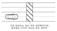
도 2 및 도 3은 본 발명에 따라 정밀 지도의 오류로 인하여 주행 경로 제어모듈에서 주행 제어정보를 수정하는 것을 나타내는 예시도.
도 4는 본 발명에 따라 정밀 지도에 오류가 존재하여도 주행 경로 제어모듈에서 주행 경로를 유지하는 것을 나타내는 예시도.
도 5는 본 발명에 따라 정밀 지도에 오류가 존재하여 주행 경로 제어모듈에서 우회경로를 생성하는 것을 나타내는 예시도.
도 6은 본 발명에 따라 오류 판단모듈에서 V2X 정보를 비교하는 일 예를 나타내는 예시도.
도 7은 본 발명의 다른 실시예에 따른 정밀 지도의 오류 판단 방법의 구성도.
도 8은 본 발명의 다른 실시예에 따라 정밀 지도의 오류를 검증하고 주행 경로의 우회여부를 판단하는 플로우를 나타내는 순서도.
30 : V2X 모듈
100 : 기준정보 획득모듈 110 : 센서 데이터 수신부
120 : V2X 데이터 수신부
200 : 오류 판단모듈 210 : 센싱 데이터 비교부
220 : V2X 데이터 비교부
300 : 지도 오류 수정모듈 310 : 수정 여부 판단부
320 : 정밀 지도 수정부
400 : 주행 경로 제어모듈
Claims (21)
- 자율 주행의 경로를 안내하는 정밀 지도와 비교하기 위한 기준정보를 자율 주행 중 실시간으로 획득하는 기준정보 획득모듈;
상기 정밀 지도상의 데이터를 기준정보와 비교하여 정밀 지도의 오류 여부를 판단하는 오류 판단모듈; 및
상기 기준정보에 의한 정밀 지도상의 데이터 수정 여부를 결정하고 수정하는 지도 오류 수정모듈;
을 포함하는 정밀 지도의 오류 판단 장치. - 청구항 1에 있어서,
상기 기준정보 획득모듈은,
자율 주행 중인 차량에 구비된 라이더 센서에 의해 정밀 지도상의 데이터와 비교하기 위한 주변 사물에 대한 사물 센싱 데이터를 기준정보로 획득하는 센서 데이터 수신부;
를 포함하는 정밀 지도의 오류 판단 장치. - 청구항 2에 있어서,
상기 센서 데이터 수신부는,
상기 라이더 센서에서 획득한 사물 센싱 데이터에 더하여, 차량에 구비된 카메라에 의해 획득한 이미지를 기준정보로 함께 획득하는 것을 특징으로 하는 정밀 지도의 오류 판단 장치. - 청구항 1에 있어서,
상기 기준정보 획득모듈은,
주변 차량과의 데이터 통신을 위한 V2X(Vehicle to everything) 모듈에 의해 적어도 하나 이상의 다른 차량으로부터 수신하는 비교 지도 데이터를 기준정보로 획득하는 V2X 데이터 수신부;
를 더 포함하는 정밀 지도의 오류 판단 장치. - 청구항 2에 있어서,
상기 오류 판단모듈은, 상기 기준정보를 정밀 지도상의 해당 사물에 대한 데이터와 비교하여 두 데이터 상호간의 일치 여부를 판단하고, 일치하지 않을 경우 정밀 지도에 오류가 있는 것으로 인식하는 센싱 데이터 비교부;
를 포함하는 정밀 지도의 오류 판단 장치. - 청구항 5에 있어서,
상기 센싱 데이터 비교부는,
상기 센서 데이터 수신부에서 획득한 신호등 정보와 도론 노면 정보 및 차선 정보로 이루어진 사물 센싱 데이터를 정밀 지도에 포함되어 있는 신호등 정보와 도로 노면 정보 및 차선 정보와 각각 비교하여, 정밀 지도에서 각 사물에 대한 존재 여부, 위치, 유형 또는 모양 중 적어도 하나의 데이터에 오류가 존재하는지 여부를 판단하는 것을 특징으로 하는 정밀 지도의 오류 판단 장치. - 청구항 4에 있어서,
상기 오류 판단모듈은,
상기 V2X 데이터 수신부에서 다른 차량으로부터 수신한 비교 지도 데이터를 정밀 지도상의 데이터와 비교하여 두 데이터 상호간의 일치 여부를 판단하고, 일치하지 않을 경우 정밀 지도상의 데이터에 오류가 있는 것으로 인식하는 V2X 데이터 비교부;
를 더 포함하는 정밀 지도의 오류 판단 장치. - 청구항 7에 있어서,
상기 오류 판단모듈은,
비교하고자 하는 정밀 지도상의 데이터와 상기 V2X 데이터 수신부에서 수신한 비교 지도 데이터의 총량이 실시간 처리가 가능한 일정 기준의 양을 초과할 경우, 자율 주행 중인 차량의 주행 경로와 겹쳐지는 영역만을 비교대상으로 결정하여 정밀 지도의 오류 여부를 판단하는 비교대상 특정부;
를 더 포함하는 정밀 지도의 오류 판단 장치. - 청구항 2에 있어서,
상기 지도 오류 수정모듈은,
상기 오류 판단모듈에서 정밀 지도에 오류가 있는 것으로 판단된 경우, 상기 기준정보 획득모듈에서 획득한 기준정보에 의해 정밀 지도상의 데이터를 수정하는 정밀 지도 수정부;
를 포함하는 정밀 지도의 오류 판단 장치. - 청구항 9에 있어서,
상기 지도 오류 수정모듈은,
상기 기준정보 획득모듈에서 획득한 사물 센싱 데이터와 비교 지도 데이터가 정밀 지도상의 데이터를 교체할 수 있을 정도로 신뢰성을 갖는 데이터인지 여부를 확인할 수 있도록, 데이터 수정을 위한 수정 기준의 충족 여부를 판단하는 수정여부 판단부;
를 더 포함하는 정밀 지도의 오류 판단 장치. - 청구항 2에 있어서,
상기 오류 판단모듈에서의 판단 결과 정밀 지도에 오류가 있는 것으로 판단되고, 해당 오류 부분이 자율 주행을 위한 주행 경로상에 있을 경우, 자율 주행을 위한 주행 제어정보를 수정하는 주행 경로 제어모듈;
을 더 포함하는 정밀 지도의 오류 판단 장치. - 청구항 11에 있어서,
상기 주행 경로 제어모듈은,
정밀 지도의 오류 존재 영역이 주행 경로상에 있을 경우, 상기 오류 존재 영역을 주행하는 차량의 가감속 여부와 차선 변경여부를 포함하는 차량의 주행 제어정보를 오류가 수정된 내용에 따라 변경하는 것을 특징으로 하는 정밀 지도의 오류 판단 장치. - 청구항 11에 있어서,
상기 주행 경로 제어모듈은,
정밀 지도상에 존재하는 오류에 의하여 차량이 현재의 주행 경로로 주행을 지속하기 어렵다고 판단될 경우, 현재 위치에서 오류 존재 영역을 회피하여 목적지에 도달할 수 있는 우회경로를 생성한 후, 생성된 우회경로를 새로운 주행 경로로 수정하여 자율 주행을 지속하는 것을 특징으로 하는 정밀 지도의 오류 판단 장치. - 청구항 11에 있어서,
상기 주행 경로 제어모듈은,
정밀 지도상의 오류 존재 영역이 현재의 주행 경로와 중복되고, 목적지에 도달할 수 있는 우회경로를 생성하지 못하는 것으로 판단될 경우, 차량을 긴급 정차시킨 후 운전자에게 차량의 제어권을 넘기도록 제어하는 것을 특징으로 하는 정밀 지도의 오류 판단 장치. - 자율 주행의 경로를 안내하는 정밀 지도와 비교하기 위한 기준정보를 자율 주행 중 실시간으로 획득하는 기준정보 획득단계;
상기 정밀 지도상의 데이터를 기준정보와 비교하여 정밀 지도의 오류 여부를 판단하는 오류 판단단계; 및
상기 기준 정보에 의한 정밀 지도상의 데이터 수정 여부를 결정하고 수정하는 지도 오류 수정단계;
를 포함하는 정밀 지도의 오류 판단 방법. - 청구항 15에 있어서,
상기 기준정보 획득단계는,
차량에 구비된 라이더 센서에서 인식되는 주변 사물의 존부, 위치 및 외형과 관련된 사물 센싱 데이터를 정밀 지도상의 데이터와 비교하기 위한 기준정보로 획득하는 센서 데이터 수신과정;
을 포함하는 정밀 지도의 오류 판단 방법. - 청구항 15에 있어서,
상기 기준정보 획득단계는,
주변 차량과의 데이터 통신을 위한 V2X(Vehicle to everything) 모듈에 의해 주변의 다른 차량으로부터 수신하는 비교 지도 데이터를 기준정보로 획득하는 V2X 데이터 수신과정;
을 포함하는 정밀 지도의 오류 판단 방법. - 청구항 15에 있어서,
상기 오류 판단단계에서의 판단 결과 정밀 지도에 오류가 있는 것으로 판단되고, 해당 오류 부분이 자율 주행을 위한 주행 경로상에 있을 경우 자율 주행을 위한 주행 제어정보를 수정하는 주행 경로 제어단계;
를 더 포함하는 정밀 지도의 오류 판단 방법. - 청구항 18에 있어서,
상기 주행 경로 제어단계는,
정밀 지도의 오류 존재 영역이 주행 경로상에 있을 경우, 상기 오류 존재 영역을 자율 주행하는 차량의 가감속 여부와 차선 변경여부를 포함하는 차량의 주행 제어정보를 오류가 수정된 내용에 따라 변경하도록 제어하는 것을 특징으로 하는 정밀 지도의 오류 판단 방법. - 청구항 18에 있어서,
상기 주행 경로 제어단계는,
정밀 지도상에 존재하는 오류에 의하여 차량이 현재 주행 경로로 주행을 지속하기 어렵다고 판단될 경우, 현재 위치에서 오류 존재 영역을 회피하여 목적지에 도달할 수 있는 우회경로를 생성한 후, 생성된 우회경로를 새로운 주행 경로로 수정하여 자율 주행이 지속되도록 제어하는 것을 특징으로 하는 정밀 지도의 오류 판단 방법. - 청구항 18에 있어서,
상기 주행 경로 제어단계는,
정밀 지도상의 오류 존재 영역이 현재의 주행 경로와 중복됨에도 불구하고, 목적지에 도달할 수 있는 우회경로를 생성하지 못하는 것으로 판단될 경우, 차량을 긴급 정차시킨 후 운전자에게 차량의 제어권을 넘기도록 제어하는 것을 특징으로 하는 정밀 지도의 오류 판단 방법.
Priority Applications (3)
| Application Number | Priority Date | Filing Date | Title |
|---|---|---|---|
| KR1020200154947A KR20220068043A (ko) | 2020-11-18 | 2020-11-18 | 정밀 지도의 오류 판단 장치 및 방법 |
| US17/499,119 US20220155081A1 (en) | 2020-11-18 | 2021-10-12 | Apparatus and method for determining error of precise map |
| CN202111287009.1A CN114543821A (zh) | 2020-11-18 | 2021-11-02 | 用于确定精确地图的错误的装置和方法 |
Applications Claiming Priority (1)
| Application Number | Priority Date | Filing Date | Title |
|---|---|---|---|
| KR1020200154947A KR20220068043A (ko) | 2020-11-18 | 2020-11-18 | 정밀 지도의 오류 판단 장치 및 방법 |
Publications (1)
| Publication Number | Publication Date |
|---|---|
| KR20220068043A true KR20220068043A (ko) | 2022-05-25 |
Family
ID=81586564
Family Applications (1)
| Application Number | Title | Priority Date | Filing Date |
|---|---|---|---|
| KR1020200154947A Pending KR20220068043A (ko) | 2020-11-18 | 2020-11-18 | 정밀 지도의 오류 판단 장치 및 방법 |
Country Status (3)
| Country | Link |
|---|---|
| US (1) | US20220155081A1 (ko) |
| KR (1) | KR20220068043A (ko) |
| CN (1) | CN114543821A (ko) |
Cited By (1)
| Publication number | Priority date | Publication date | Assignee | Title |
|---|---|---|---|---|
| KR20240059737A (ko) * | 2022-10-26 | 2024-05-08 | (주) 하나텍시스템 | 인프라 가이던스 정보에 대한 실주행 오차 원인분석방법 |
Families Citing this family (5)
| Publication number | Priority date | Publication date | Assignee | Title |
|---|---|---|---|---|
| CN121734450A (zh) * | 2020-07-08 | 2026-03-27 | 株式会社电装 | 自动驾驶装置、车辆控制方法 |
| KR20220105777A (ko) * | 2021-01-21 | 2022-07-28 | 현대자동차주식회사 | 주행 정보 기반 지도 생성 장치 및 방법 |
| EP4191275B1 (en) * | 2021-12-03 | 2025-08-13 | Nxp B.V. | V2x for sensor cross checks and diagnosis |
| US20230311946A1 (en) * | 2022-03-31 | 2023-10-05 | Tusimple, Inc. | Localization techniques for autonomous driving operations |
| JP2024168131A (ja) * | 2023-05-23 | 2024-12-05 | トヨタ自動車株式会社 | 経路誤変換判定装置及び経路誤変換判定装置の経路誤変換判定方法 |
Family Cites Families (8)
| Publication number | Priority date | Publication date | Assignee | Title |
|---|---|---|---|---|
| CN106776996B (zh) * | 2016-12-02 | 2018-09-07 | 百度在线网络技术(北京)有限公司 | 用于测试高精度地图的准确性的方法和装置 |
| CN110832474B (zh) * | 2016-12-30 | 2023-09-15 | 辉达公司 | 更新高清地图的方法 |
| US20190137287A1 (en) * | 2017-06-27 | 2019-05-09 | drive.ai Inc. | Method for detecting and managing changes along road surfaces for autonomous vehicles |
| CN108319655B (zh) * | 2017-12-29 | 2021-05-07 | 百度在线网络技术(北京)有限公司 | 用于生成栅格地图的方法和装置 |
| US10684131B2 (en) * | 2018-01-04 | 2020-06-16 | Wipro Limited | Method and system for generating and updating vehicle navigation maps with features of navigation paths |
| CN112005079B (zh) * | 2019-01-03 | 2022-08-09 | 北京嘀嘀无限科技发展有限公司 | 用于更新高清地图的系统和方法 |
| US11593344B2 (en) * | 2019-07-02 | 2023-02-28 | Nvidia Corporation | Updating high definition maps based on age of maps |
| WO2021041402A1 (en) * | 2019-08-26 | 2021-03-04 | Mobileye Vision Technologies Ltd. | Systems and methods for vehicle navigation |
-
2020
- 2020-11-18 KR KR1020200154947A patent/KR20220068043A/ko active Pending
-
2021
- 2021-10-12 US US17/499,119 patent/US20220155081A1/en not_active Abandoned
- 2021-11-02 CN CN202111287009.1A patent/CN114543821A/zh active Pending
Cited By (1)
| Publication number | Priority date | Publication date | Assignee | Title |
|---|---|---|---|---|
| KR20240059737A (ko) * | 2022-10-26 | 2024-05-08 | (주) 하나텍시스템 | 인프라 가이던스 정보에 대한 실주행 오차 원인분석방법 |
Also Published As
| Publication number | Publication date |
|---|---|
| CN114543821A (zh) | 2022-05-27 |
| US20220155081A1 (en) | 2022-05-19 |
Similar Documents
| Publication | Publication Date | Title |
|---|---|---|
| KR20220068043A (ko) | 정밀 지도의 오류 판단 장치 및 방법 | |
| JP7260064B2 (ja) | 自車位置推定装置、走行位置推定方法 | |
| KR20190133623A (ko) | 적어도 하나의 자동차의 가이드를 지원하기 위한 방법, 보조 시스템 및 자동차 | |
| US8560220B2 (en) | Method and apparatus for determining a plausible lane for guiding a vehicle and an automobile | |
| JP2019219986A (ja) | 自動運転支援システム | |
| US9470537B2 (en) | Accurate position determination near exit lanes | |
| US20210024082A1 (en) | Traffic signal interpretation system and vehicle control system | |
| KR20170097435A (ko) | 자율주행 시스템에서의 교차로 우회전 판단 장치 및 그 방법 | |
| CN114613129A (zh) | 用于判断交通信号灯状态的方法、程序产品和系统 | |
| JP7255706B2 (ja) | 信号機認識方法及び信号機認識装置 | |
| KR20210100241A (ko) | 내비게이션 연동을 이용한 차선 표시용 램프 시스템 및 이에 의한 차선 표시 방법 | |
| KR101281499B1 (ko) | 자동차 자동 운행 시스템 | |
| US20230349719A1 (en) | Map generation apparatus, map generation program and on-vehicle equipment | |
| CN115171371B (zh) | 一种协作式道路交叉口通行方法及装置 | |
| KR20190064228A (ko) | 이미지 센싱을 이용한 차선 정보 제공 장치, 차선 정보 제공 방법 및 이를 이용한 차량 제어 방법 | |
| JP6805704B2 (ja) | 経路選択方法及び経路選択装置 | |
| KR102699000B1 (ko) | 교통신호 인식방법 및 시스템 | |
| US10665103B2 (en) | Vehicle periphery information verification device and method | |
| US20220264268A1 (en) | Cooperative adas and cooperative safety systems and methods using v2x communications | |
| CN112365730A (zh) | 自动驾驶方法、装置、设备、存储介质以及车辆 | |
| US20230102760A1 (en) | Apparatus for detecting a traffic flow obstruction target and a method thereof | |
| JP7258094B2 (ja) | 目標経路生成装置および目標経路生成方法 | |
| JP2008102684A (ja) | 路上標示認識装置およびカーナビゲーションシステム | |
| JP6978470B2 (ja) | 運転支援システム、プログラム | |
| JP6941677B2 (ja) | 画像認識装置 |
Legal Events
| Date | Code | Title | Description |
|---|---|---|---|
| PA0109 | Patent application |
St.27 status event code: A-0-1-A10-A12-nap-PA0109 |
|
| PN2301 | Change of applicant |
St.27 status event code: A-3-3-R10-R13-asn-PN2301 St.27 status event code: A-3-3-R10-R11-asn-PN2301 |
|
| PG1501 | Laying open of application |
St.27 status event code: A-1-1-Q10-Q12-nap-PG1501 |
|
| PA0201 | Request for examination |
St.27 status event code: A-1-2-D10-D11-exm-PA0201 |
|
| D21 | Rejection of application intended |
Free format text: ST27 STATUS EVENT CODE: A-1-2-D10-D21-EXM-PE0902 (AS PROVIDED BY THE NATIONAL OFFICE) |
|
| PE0902 | Notice of grounds for rejection |
St.27 status event code: A-1-2-D10-D21-exm-PE0902 |
|
| P22-X000 | Classification modified |
St.27 status event code: A-2-2-P10-P22-nap-X000 |
|
| P11 | Amendment of application requested |
Free format text: ST27 STATUS EVENT CODE: A-2-2-P10-P11-NAP-X000 (AS PROVIDED BY THE NATIONAL OFFICE) |
|
| P11-X000 | Amendment of application requested |
St.27 status event code: A-2-2-P10-P11-nap-X000 |
|
| P13 | Application amended |
Free format text: ST27 STATUS EVENT CODE: A-2-2-P10-P13-NAP-X000 (AS PROVIDED BY THE NATIONAL OFFICE) |
|
| P13-X000 | Application amended |
St.27 status event code: A-2-2-P10-P13-nap-X000 |