RU2313103C1 - Method for single-frequency determination of delay of satellite navigation system signals in ionosphere - Google Patents
Method for single-frequency determination of delay of satellite navigation system signals in ionosphere Download PDFInfo
- Publication number
- RU2313103C1 RU2313103C1 RU2006120208/09A RU2006120208A RU2313103C1 RU 2313103 C1 RU2313103 C1 RU 2313103C1 RU 2006120208/09 A RU2006120208/09 A RU 2006120208/09A RU 2006120208 A RU2006120208 A RU 2006120208A RU 2313103 C1 RU2313103 C1 RU 2313103C1
- Authority
- RU
- Russia
- Prior art keywords
- ionosphere
- delay
- signal
- navigation
- nap
- Prior art date
Links
- 239000005433 ionosphere Substances 0.000 title claims abstract description 27
- 238000000034 method Methods 0.000 title claims description 9
- 239000005436 troposphere Substances 0.000 claims description 9
- 230000005855 radiation Effects 0.000 claims description 4
- 229920006395 saturated elastomer Polymers 0.000 claims description 2
- 230000000694 effects Effects 0.000 abstract description 3
- 238000011156 evaluation Methods 0.000 abstract 2
- 239000000126 substance Substances 0.000 abstract 1
- 238000004364 calculation method Methods 0.000 description 4
- 238000005259 measurement Methods 0.000 description 3
- 238000012937 correction Methods 0.000 description 2
- 230000007423 decrease Effects 0.000 description 1
- 230000007613 environmental effect Effects 0.000 description 1
- 230000001902 propagating effect Effects 0.000 description 1
- 230000001360 synchronised effect Effects 0.000 description 1
- XLYOFNOQVPJJNP-UHFFFAOYSA-N water Chemical compound O XLYOFNOQVPJJNP-UHFFFAOYSA-N 0.000 description 1
Landscapes
- Position Fixing By Use Of Radio Waves (AREA)
Abstract
Description
Предлагаемое изобретение относится к области спутниковой навигации и может быть использовано для определения ионосферной задержки распространения сигналов глобальных навигационных спутниковых систем (ГНСС) с помощью навигационной аппаратуры потребителя, работающей на одной частоте.The present invention relates to the field of satellite navigation and can be used to determine the ionospheric delay propagation of signals from global navigation satellite systems (GNSS) using consumer navigation equipment operating on a single frequency.
Все связи между приземными потребителями и навигационными космическими аппаратами (НКА) осуществляются через атмосферу Земли, включая тропосферу и ионосферу. Атмосфера имеет ярко выраженную частотную избирательность. Неоднородное по высоте распределение диэлектрической проницаемости вызывает искривление траектории распространения радиоволн - рефракцию. Вследствие этого, на рабочей частоте НКА (1,6 ГГц) погрешность определения псевдодальности составляет от 5 до 50 метров. Основное влияние на задержку радиосигнала в ионосфере вносит электронная концентрация, которая постоянно изменяется в зависимости от времени (часа суток, сезона, фазы цикла солнечной активности), географических координат, высоты над уровнем моря, от солнечной активности.All communications between surface consumers and navigation spacecraft (NSC) are made through the Earth’s atmosphere, including the troposphere and ionosphere. The atmosphere has a pronounced frequency selectivity. The inhomogeneous distribution of dielectric constant causes a curvature of the path of propagation of radio waves - refraction. As a result, at the operating frequency of the spacecraft (1.6 GHz), the error in determining the pseudorange is from 5 to 50 meters. The main influence on the delay of the radio signal in the ionosphere is made by the electron concentration, which constantly changes depending on time (hour of the day, season, phase of the solar activity cycle), geographical coordinates, altitude, and solar activity.
Известен способ определения задержки сигналов в ионосфере на одной частоте [1], заключающийся в измерении разности между псевдодальностями, измеренными по дальномерному коду и по фазе несущей частоты, основан на том, что в ионосфере скорость распространения модулирующего сигнала меньше скорости света. Разность измерений псевдодальности по задержке кода и по фазе несущей частоты равна удвоенной ионосферной задержке сигнала и может быть использована для ее определения.A known method for determining the delay of signals in the ionosphere at one frequency [1], which consists in measuring the difference between the pseudoranges measured by the rangefinder code and the phase of the carrier frequency, is based on the fact that in the ionosphere the propagation speed of the modulating signal is less than the speed of light. The difference between the pseudorange measurements by the code delay and the phase of the carrier frequency is equal to twice the ionospheric delay of the signal and can be used to determine it.
Оценка величины задержки сигналов и начальной неоднозначности фазовых измерений в данном способе производится при помощи фильтра Калмана. Размерность вектора состояния, используемого в фильтре, зависит от числа навигационных космических аппаратов и аппроксимирующего полинома.The magnitude of the signal delay and the initial ambiguity of phase measurements in this method are estimated using the Kalman filter. The dimensionality of the state vector used in the filter depends on the number of navigation spacecraft and the approximating polynomial.
Недостатком данного метода является большая размерность вектора состояния, что влечет за собой большой объем вычислений и, как следствие, увеличение времени расчета. При устранении фазовой неоднозначности значительно увеличивается время первого отсчета и снижается устойчивость системы.The disadvantage of this method is the large dimension of the state vector, which entails a large amount of calculations and, as a consequence, an increase in the calculation time. When phase ambiguity is eliminated, the time of the first countdown significantly increases and the stability of the system decreases.
Известен способ определения задержки сигналов ГНСС в ионосфере на одной частоте [2, с.83], взятый в качестве прототипа, основанный на применении упрощенной модели интегральной электронной концентрации ионосферы. В алгоритме используется аппроксимация вариации электронной концентрации положительной полуволной в дневные часы и постоянной величиной - в ночные. Исходными данными для расчета ионосферных поправок являются приближенные значения координат навигационной аппаратуры потребителя (НАП), угол места, азимут навигационных космических аппаратов, время и коэффициенты модели. Коэффициенты модели передаются в навигационном сообщении системы GPS (Global Position System) и обновляются каждые 6 дней [3].A known method for determining the delay of GNSS signals in the ionosphere at a single frequency [2, p. 83], taken as a prototype, based on the use of a simplified model of the integrated electron concentration of the ionosphere. The algorithm uses an approximation of the variation in the electron concentration of the positive half-wave in the daytime and a constant value at night. The initial data for calculating ionospheric corrections are approximate coordinates of the consumer navigation equipment (NAP), elevation, azimuth of navigation spacecraft, time and model coefficients. The coefficients of the model are transmitted in the navigation message of the GPS system (Global Position System) and updated every 6 days [3].
Недостатком данного способа является низкая точность определения задержки сигналов в ионосфере, обусловленная устареванием информации, невозможность оценки локального изменения электронной концентрации. Кроме того, алгоритм плохо воспроизводит поведение ионосферы на экваториальных широтах ввиду ограниченной возможности кубической аппроксимации. Использовать алгоритм на высоких широтах не целесообразно, т.к. интегральная электронная концентрация меньше, чем на средних и низких широтах, а ее вариации во времени значительны. Коэффициенты модели не передаются в составе Российской системы ГНСС ГЛОНАСС. Вышеперечисленные недостатки значительно сужают применимость данной системы, особенно для российских пользователей.The disadvantage of this method is the low accuracy of determining the delay of signals in the ionosphere, due to outdated information, the inability to assess local changes in electron concentration. In addition, the algorithm poorly reproduces the behavior of the ionosphere at equatorial latitudes due to the limited possibility of cubic approximation. Using the algorithm at high latitudes is not advisable, because the integral electron concentration is lower than at middle and low latitudes, and its variations in time are significant. Model coefficients are not transmitted as part of the GNSS GLONASS Russian system. The above disadvantages significantly narrow the applicability of this system, especially for Russian users.
В основу изобретения положена задача обеспечения возможности оценки электронной концентрации в ионосфере в режиме реального времени, с высокой точностью и с малым объемом вычислительных операций, как для потребителей отечественной, так и для потребителей зарубежной систем.The basis of the invention is the task of providing the possibility of estimating the electron concentration in the ionosphere in real time, with high accuracy and with a small amount of computing operations, both for domestic consumers and consumers of foreign systems.
Поставленная задача решается тем, что в способе одночастотного определения задержки сигналов навигационной спутниковой системы в ионосфере, основанном на оценке электронной концентрации в ионосфере, согласно изобретению в навигационной аппаратуре потребителя измеряют температуру, влажность и давление окружающей среды, рассчитывают интегральный показатель коэффициента преломления сигнала в тропосфере по формуле:The problem is solved in that in the method of single-frequency determination of the delay of the signals of the navigation satellite system in the ionosphere, based on the assessment of the electron concentration in the ionosphere, according to the invention, the temperature, humidity and pressure of the environment are measured in the navigation equipment of the consumer, the integral index of the refractive index of the signal in the troposphere is calculated from the formula:
![]()
![]()
где: i=1...N число сигналов, принимаемых навигационной аппаратурой потребителя от навигационных космических аппаратов;where: i = 1 ... N is the number of signals received by the navigation equipment of the consumer from the navigation spacecraft;
νn=ν0e-b/h;ν n = ν 0 e -b / h ;
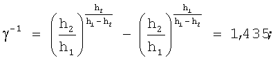
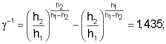
![]()
![]()
b=136 м; h=8 км; h1=25 км; h2=3 км;b = 136 m; h = 8 km; h 1 = 25 km; h 2 = 3 km;
Р - давление воздуха;P is the air pressure;
Т - температура воздуха;T is the air temperature;
е - давление водяного пара в миллибарах, рассчитанное по формулеe - water vapor pressure in millibars, calculated by the formula
![]()
![]()
где: J - относительная влажность;where: J is relative humidity;
Pп(T) - давление насыщенного пара в миллибарах,P p (T) is the saturated vapor pressure in millibars,
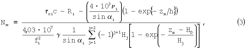
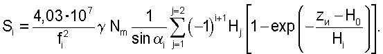
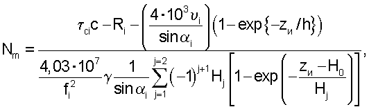
и оценивают электронную концентрацию в реальном масштабе времени по формуле:and evaluate the electronic concentration in real time according to the formula:
где: Н0=200 км;where: H 0 = 200 km;
H1=325 км;H 1 = 325 km;
H2=32,5 км;H 2 = 32.5 km;
![]()
![]()
Rе - радиус Земли;R e is the radius of the Earth;
αi - угол места i-го НКА относительно НАП;α i - elevation angle of the i-th spacecraft relative to the NAP;
Ri - расстояние от i-го НКА до приемника излучения;R i is the distance from the i-th satellite to the radiation receiver;
с - скорость света в вакууме;c is the speed of light in vacuum;
fi - частота сигнала i-го НКА;f i is the signal frequency of the i-th spacecraft;
τci - измеренное время распространения сигнала от i-го НКА до НАП;τ ci is the measured propagation time of the signal from the i-th satellite to the NAP;
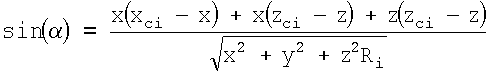
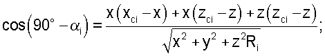
![]()
![]()
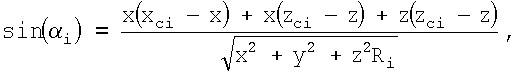
где: x, y, z - координаты НАП;where: x, y, z - coordinates of the NAP;
xci, yci, zci - координаты i-го НКА,x ci , y ci , z ci - coordinates of the i-th satellite,
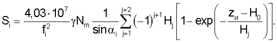
на последующие моменты времени рассчитывается задержка распространения сигнала в ионосфере по формуле:for subsequent time instants, the propagation delay of the signal in the ionosphere is calculated by the formula:
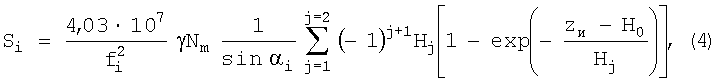
для i-го НКА.for the i-th NKA.
Для описания высотного профиля концентрации применяются различные модельные зависимости, передающие наиболее характерные особенности строения ионосферы. В настоящее время наиболее часто используют параболически-экспоненциальную модель и биэкспоненциальную модель. Из сопоставления графиков этих моделей, представленных в [4], можно сделать вывод, что обе модели приводят примерно к одинаковым результатам. Для примера рассмотрим биэкспоненциальную модель. Поправка к групповому пути для биэкспоненциальной модели профиля электронной концентрации при произвольном угле места [4] равнаTo describe the altitude concentration profile, various model dependences are used that convey the most characteristic structural features of the ionosphere. Currently, the most commonly used parabolic-exponential model and biexponential model. From a comparison of the graphs of these models presented in [4], we can conclude that both models lead to approximately the same results. For example, consider a biexponential model. The correction to the group path for the biexponential model of the electron concentration profile for an arbitrary elevation angle [4] is
Расстояние от НКА до приемника можно определить по формулеThe distance from the NKA to the receiver can be determined by the formula
![]()
![]()
Поскольку опорный генератор, находящийся на навигационной аппаратуре потребителя, не синхронен с опорным генератором, находящимся на навигационном космическом аппарате, то существует расхождение временной шкалы между НАП и НКА, соответственно дальность между i-м НКА и НАП определяется по формулеSince the reference generator located on the navigation equipment of the consumer is not synchronized with the reference generator located on the navigation spacecraft, there is a discrepancy in the time scale between the NAP and the spacecraft, respectively, the distance between the ith spacecraft and the spacecraft is determined by the formula
![]()
![]()
где τci - время распространения сигнала от i-го НКА до НАП;where τ ci is the propagation time of the signal from the i-th satellite to the NAP;
с - скорость света:C is the speed of light:
Δt - расхождения временных шкал между НАП и навигационной системой.Δt is the discrepancy between the time scales between the NAP and the navigation system.
Угол места НКА относительно НАП можно определить по формулеThe angle of the spacecraft relative to the NAP can be determined by the formula
Задержка распространения сигнала от НКА до НАП зависит от геометрической дальности, от задержки распространения сигнала в ионосфере и тропосфере. Уравнение для определения задержки будет иметь видThe delay in the propagation of a signal from a spacecraft to a NAP depends on the geometric distance and on the propagation delay of the signal in the ionosphere and troposphere. The equation for determining the delay will be
![]()
![]()
где: ![]()
![]()
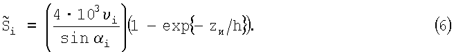
Рассмотрим влияние тропосферы на рефракцию излучаемого сигнала с НКА. В диапазоне радиочастот индекс преломления зависит от параметров тропосферы [4]Let us consider the influence of the troposphere on the refraction of the emitted signal from a satellite. In the radio frequency range, the refractive index depends on the parameters of the troposphere [4]
ν0=77,6Р/Т+3,73·105 е/Т2.ν 0 = 77.6P / T + 3.73 · 10 5 e / T 2 .
Это соотношение дает ошибку менее 0,5% для частот до 100 ГГц [4]. Зависимость давления водяного пара от температуры является табличным значением и можно взять, например, в [5]. При расчете радиофизических характеристик распространяющегося в тропосфере сигнала будем использовать экспоненциальную модель высотного профиля коэффициента преломления, так чтоThis ratio gives an error of less than 0.5% for frequencies up to 100 GHz [4]. The dependence of water vapor pressure on temperature is a tabular value and can be taken, for example, in [5]. In calculating the radiophysical characteristics of the signal propagating in the troposphere, we will use the exponential model of the altitude profile of the refractive index, so that
νn=ν0e-b/h,ν n = ν 0 e -b / h ,
Из этого выражения можно оценить νn и рассчитать интегральный показатель коэффициента преломления [4] для i-го НКАFrom this expression, we can estimate ν n and calculate the integral index of refractive index [4] for the i-th satellite

В приближении плоской Земли для i-го НКА задержку распространения сигнала можно определитьIn the flat earth approximation for the i-th spacecraft, the propagation delay of the signal can be determined
Окончательно выражение для расчета времени распространения сигнала от i-го НКА до НАП определяетсяFinally, the expression for calculating the propagation time of the signal from the i-th spacecraft to the NAP is determined
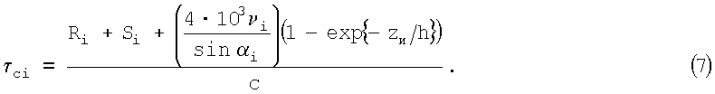
Тогда выражение для определения задержки распространения сигнала от i-го НКА до НАП в ионосфере будет иметь видThen the expression for determining the propagation delay of the signal from the ith SCA to the NAP in the ionosphere will have the form

Выражение для определения электронной концентрации в ионосфере можно определить по формулеThe expression for determining the electron concentration in the ionosphere can be determined by the formula

Для вычисления задержки времени распространения сигнала в ионосфере достаточно проводить одновременное измерение навигационных параметров по 5 НКА.To calculate the delay time of the propagation of a signal in the ionosphere, it is sufficient to carry out a simultaneous measurement of navigational parameters from 5 NCA.
Как показывают экспериментальные данные [2] вариация ионосферы в течение суток может составлять до пяти раз. Если не учитывать мелкие неоднородности, то на некотором интервале времени электронную концентрацию можно считать постоянной и одинаковой для всех НКА, что позволяет в дальнейшем, на некотором интервале времени, считать величину Nm константой.As experimental data show [2], the variation of the ionosphere during the day can be up to five times. If minor inhomogeneities are not taken into account, then over a certain time interval the electron concentration can be considered constant and the same for all the spacecraft, which allows us to further consider the value of N m as a constant over a certain time interval.
Оценивая электронную концентрацию по одному из НКА, можно скорректировать измеренные псевдодальности и получить более точные координаты навигационной аппаратуры потребителя по алгоритму, изложенному в [2].Estimating the electronic concentration using one of the NKA, one can correct the measured pseudorange and obtain more accurate coordinates of the consumer navigation equipment according to the algorithm described in [2].
Алгоритм вычисления задержки сигналов в навигационной спутниковой системе представлен на фиг.1. В начале алгоритма проводится проверка количества радиовидимых космических аппаратов (N), если число радиовидимых НКА не менее четырех, тогда производится измерение температуры, влажности и давления окружающей среды, а также время распространения сигнала от i-го НКА до НАП (τci). По четырем НКА производится оценка координат НАП (5). По измеренным параметрам окружающей среды определяют задержку распространения сигнала от i-го НКА до НАП в тропосфере (6). Расчет электронной концентрации проводится, если N>4, при этом по оставшимся измеренным τci, не участвовавшим в расчете координат НАП, определяют электронную концентрацию (3). Если N>5, тогда находят среднее значение электронной концентрации. По полученному значению электронной концентрации вычисляется задержка распространения сигнала в ионосфере. Данный алгоритм можно реализовать на программном уровне с применением стандартного вычислительного модуля, например FC-303 фирмы FASTWEL, или на аналогичном вычислителе, применяемом в ПЭВМ.The algorithm for calculating the delay of signals in a navigation satellite system is presented in figure 1. At the beginning of the algorithm, the number of radio-visible spacecraft (N) is checked, if the number of radio-visible spacecraft is at least four, then the temperature, humidity and pressure of the environment are measured, as well as the signal propagation time from the ith spacecraft to the spacecraft (τ ci ). Based on four spacecraft, the coordinates of the NAP are estimated (5). Using the measured environmental parameters, the signal propagation delay from the ith SCA to the NAP in the troposphere is determined (6). The calculation of the electron concentration is carried out if N> 4, and the electron concentration is determined from the remaining measured τ ci , which did not participate in the calculation of the NAP coordinates, (3). If N> 5, then find the average value of the electron concentration. Based on the obtained value of the electron concentration, the propagation delay of the signal in the ionosphere is calculated. This algorithm can be implemented at the software level using a standard computing module, for example, FC-303 from FASTWEL, or on a similar computer used in a PC.
Таким образом, предлагаемый способ оценки электронной концентрации в ионосфере позволяет в режиме реального времени, с высокой точностью и с малым объемом вычислительных операций определить задержку сигналов спутниковой навигационной системы в ионосфере.Thus, the proposed method for estimating the electron concentration in the ionosphere allows real-time, with high accuracy and with a small amount of computational operations to determine the delay of the signals of the satellite navigation system in the ionosphere.
Источники информацииInformation sources
1. Nisner P., Trethewey V. GPS Ionospheric Determinathions Using LI Only // Proceeding of the 5th International conference on «Differential Satellite Navigathion System». Additional Volume, St. Peterburg, Russia, May, 1996.1. Nisner P., Trethewey V. GPS Ionospheric Determinathions Using LI Only // Proceeding of the 5 th International conference on "Differential Satellite Navigathion System". Additional Volume, St. Peterburg, Russia, May, 1996.
2. В.С.Шебшаевич, П.П.Дмитриев и др. Сетевые спутниковые радионавигационные системы. - М.: «Радио и связь», 1993. - 408 с.2. V.S.Shebshaevich, P.P.Dmitriev and others. Network satellite radio navigation systems. - M.: “Radio and Communications”, 1993. - 408 p.
3. ICD-GPS-200, Revision C, U.S. Government, October 10, 1993.3. ICD-GPS-200, Revision C, U.S. Government, October 10, 1993.
4. Р.В.Бакитько, М.Б.Васильев, А.С.Виницкий. Радиосистемы межпланетных космических аппаратов. - М: «Радио и связь», 1993 г.4. R.V. Bakitko, M. B. Vasiliev, A. S. Vinitsky. Interplanetary spacecraft radio systems. - M: "Radio and communications", 1993
5. С.З.Сапожников, Э.Л.Китанин. Техническая термодинамика и теплопередача. Санкт-Петербург, издательство СПбГПУ, 2003 г.5. S.Z. Sapozhnikov, E.L. Kitanin. Technical thermodynamics and heat transfer. St. Petersburg, publishing house SPbSPU, 2003
Claims (1)
Priority Applications (1)
| Application Number | Priority Date | Filing Date | Title |
|---|---|---|---|
| RU2006120208/09A RU2313103C1 (en) | 2006-06-08 | 2006-06-08 | Method for single-frequency determination of delay of satellite navigation system signals in ionosphere |
Applications Claiming Priority (1)
| Application Number | Priority Date | Filing Date | Title |
|---|---|---|---|
| RU2006120208/09A RU2313103C1 (en) | 2006-06-08 | 2006-06-08 | Method for single-frequency determination of delay of satellite navigation system signals in ionosphere |
Publications (1)
| Publication Number | Publication Date |
|---|---|
| RU2313103C1 true RU2313103C1 (en) | 2007-12-20 |
Family
ID=38917319
Family Applications (1)
| Application Number | Title | Priority Date | Filing Date |
|---|---|---|---|
| RU2006120208/09A RU2313103C1 (en) | 2006-06-08 | 2006-06-08 | Method for single-frequency determination of delay of satellite navigation system signals in ionosphere |
Country Status (1)
| Country | Link |
|---|---|
| RU (1) | RU2313103C1 (en) |
Cited By (2)
| Publication number | Priority date | Publication date | Assignee | Title |
|---|---|---|---|---|
| RU2486544C2 (en) * | 2010-10-22 | 2013-06-27 | Всеволод Борисович Иванов | Method of determining consumer coordinates in glonass/gps systems and apparatus for realising said method |
| RU2693842C1 (en) * | 2018-07-30 | 2019-07-05 | Федеральное Государственное Бюджетное Учреждение "Институт Прикладной Геофизики Имени Академика Е.К. Федорова" (Фгбу "Ипг") | Method for probing the ionosphere and troposphere |
Citations (5)
| Publication number | Priority date | Publication date | Assignee | Title |
|---|---|---|---|---|
| EP0242115A2 (en) * | 1986-04-14 | 1987-10-21 | Western Atlas International, Inc. | Method and system for determining position on a moving platform, such as a ship, using signals from GPS satellites |
| US5276451A (en) * | 1991-07-09 | 1994-01-04 | Pioneer Electronic Corporation | Navigation system with navigational data processing |
| US5867411A (en) * | 1996-12-19 | 1999-02-02 | The Aerospace Corporation | Kalman filter ionospheric delay estimator |
| RU2208809C1 (en) * | 2002-02-21 | 2003-07-20 | Красноярский государственный технический университет | Method of single-frequency determination of delay of signals of navigation satellite system in ionosphere |
| RU2251713C1 (en) * | 2003-08-12 | 2005-05-10 | Заренков Вячеслав Адамович | Method nd device for measuring electron concentration at specific region of ionosphere |
-
2006
- 2006-06-08 RU RU2006120208/09A patent/RU2313103C1/en not_active IP Right Cessation
Patent Citations (5)
| Publication number | Priority date | Publication date | Assignee | Title |
|---|---|---|---|---|
| EP0242115A2 (en) * | 1986-04-14 | 1987-10-21 | Western Atlas International, Inc. | Method and system for determining position on a moving platform, such as a ship, using signals from GPS satellites |
| US5276451A (en) * | 1991-07-09 | 1994-01-04 | Pioneer Electronic Corporation | Navigation system with navigational data processing |
| US5867411A (en) * | 1996-12-19 | 1999-02-02 | The Aerospace Corporation | Kalman filter ionospheric delay estimator |
| RU2208809C1 (en) * | 2002-02-21 | 2003-07-20 | Красноярский государственный технический университет | Method of single-frequency determination of delay of signals of navigation satellite system in ionosphere |
| RU2251713C1 (en) * | 2003-08-12 | 2005-05-10 | Заренков Вячеслав Адамович | Method nd device for measuring electron concentration at specific region of ionosphere |
Non-Patent Citations (1)
| Title |
|---|
| ШЕБШАЕВИЧ B.C. и др. Сетевые спутниковые радионавигационные системы. - М.: Радио и связь, 1993, с.83. * |
Cited By (2)
| Publication number | Priority date | Publication date | Assignee | Title |
|---|---|---|---|---|
| RU2486544C2 (en) * | 2010-10-22 | 2013-06-27 | Всеволод Борисович Иванов | Method of determining consumer coordinates in glonass/gps systems and apparatus for realising said method |
| RU2693842C1 (en) * | 2018-07-30 | 2019-07-05 | Федеральное Государственное Бюджетное Учреждение "Институт Прикладной Геофизики Имени Академика Е.К. Федорова" (Фгбу "Ипг") | Method for probing the ionosphere and troposphere |
Similar Documents
| Publication | Publication Date | Title |
|---|---|---|
| US8035552B2 (en) | Distance dependant error mitigation in real-time kinematic (RTK) positioning | |
| RU2479855C2 (en) | Distance dependant error mitigation in real-time kinematic positioning | |
| US20040135721A1 (en) | Method and system for estimating ionospheric delay using a single frequencey or dual frequency gps signal | |
| US8723725B2 (en) | Ionospheric delay compensation using a scale factor based on an altitude of a receiver | |
| Feltens | Chapman profile approach for 3-D global TEC representation | |
| US20230417924A1 (en) | Updating atmospheric delay models with a geographic region | |
| CN103235321A (en) | GPS (global positioning system) pseudo-range positioning precision timing method | |
| CN110456388A (en) | A kind of spaceborne GNSS-R sea level height element robot scaling equipment and method | |
| Nikolaidou et al. | Development and validation of comprehensive closed formulas for atmospheric delay and altimetry correction in ground-based GNSS-R | |
| Eresmaa et al. | An observation operator for ground-based GPS slant delays | |
| RU2313103C1 (en) | Method for single-frequency determination of delay of satellite navigation system signals in ionosphere | |
| RU2253128C1 (en) | Method for determination of object relative coordinates with survey to arbitrary point of space and system for its realization | |
| Brunner et al. | Theory of the local scale parameter method for EDM | |
| US20210116575A1 (en) | Updating atmospheric delay models within a geographic region | |
| US20210116574A1 (en) | Atmospheric delay estimation and compensation for single-frequency receivers | |
| RU2208809C1 (en) | Method of single-frequency determination of delay of signals of navigation satellite system in ionosphere | |
| Jehle et al. | Improved knowledge of SAR geometry through atmospheric modelling | |
| RU2584541C1 (en) | Method of identifying parameters of navigation satellites | |
| US12618983B2 (en) | Methods and systems for excess path length corrections for GNSS receivers | |
| Graffigna et al. | Consistency of different tropospheric models and mapping functions for precise GNSS processing | |
| RU131204U1 (en) | COMPLEX FOR MEASURING THE INTEGRAL CONTENT OF WATER VAPOR IN THE ATMOSPHERE ACCORDING TO SIGNALS OF THE GLOBAL NAVIGATION SATELLITE SYSTEM | |
| Turák et al. | Tomographic reconstruction of atmospheric water vapor profiles using multi-GNSS observations | |
| Graffigna | Validation of real-time zenith tropospheric delay estimation with TOMION software within WAGNSS networks | |
| Jyothi et al. | Velocity Estimation Method Considering Doppler Effect and PSO Based Algorithm for Satellites Constellation IRNSS and GPS | |
| Doma et al. | Troposphere Delay Remote Sensing Using Single GPS Receiver |
Legal Events
| Date | Code | Title | Description |
|---|---|---|---|
| MM4A | The patent is invalid due to non-payment of fees |
Effective date: 20080609 |