RU2561925C2 - Method of determining optimum configuration of forest video monitoring system - Google Patents
Method of determining optimum configuration of forest video monitoring system Download PDFInfo
- Publication number
- RU2561925C2 RU2561925C2 RU2013156177/13A RU2013156177A RU2561925C2 RU 2561925 C2 RU2561925 C2 RU 2561925C2 RU 2013156177/13 A RU2013156177/13 A RU 2013156177/13A RU 2013156177 A RU2013156177 A RU 2013156177A RU 2561925 C2 RU2561925 C2 RU 2561925C2
- Authority
- RU
- Russia
- Prior art keywords
- video monitoring
- parameters
- forest
- territory
- fire
- Prior art date
Links
Images

Classifications
-
- G—PHYSICS
- G01—MEASURING; TESTING
- G01C—MEASURING DISTANCES, LEVELS OR BEARINGS; SURVEYING; NAVIGATION; GYROSCOPIC INSTRUMENTS; PHOTOGRAMMETRY OR VIDEOGRAMMETRY
- G01C11/00—Photogrammetry or videogrammetry, e.g. stereogrammetry; Photographic surveying
- G01C11/04—Interpretation of pictures
-
- A—HUMAN NECESSITIES
- A01—AGRICULTURE; FORESTRY; ANIMAL HUSBANDRY; HUNTING; TRAPPING; FISHING
- A01G—HORTICULTURE; CULTIVATION OF VEGETABLES, FLOWERS, RICE, FRUIT, VINES, HOPS OR SEAWEED; FORESTRY; WATERING
- A01G23/00—Forestry
-
- G—PHYSICS
- G08—SIGNALLING
- G08B—SIGNALLING SYSTEMS, e.g. PERSONAL CALLING SYSTEMS; ORDER TELEGRAPHS; ALARM SYSTEMS
- G08B17/00—Fire alarms; Alarms responsive to explosion
- G08B17/005—Fire alarms; Alarms responsive to explosion for forest fires, e.g. detecting fires spread over a large or outdoors area
-
- H—ELECTRICITY
- H04—ELECTRIC COMMUNICATION TECHNIQUE
- H04N—PICTORIAL COMMUNICATION, e.g. TELEVISION
- H04N23/00—Cameras or camera modules comprising electronic image sensors; Control thereof
- H04N23/60—Control of cameras or camera modules
- H04N23/62—Control of parameters via user interfaces
-
- H—ELECTRICITY
- H04—ELECTRIC COMMUNICATION TECHNIQUE
- H04N—PICTORIAL COMMUNICATION, e.g. TELEVISION
- H04N23/00—Cameras or camera modules comprising electronic image sensors; Control thereof
- H04N23/60—Control of cameras or camera modules
- H04N23/66—Remote control of cameras or camera parts, e.g. by remote control devices
- H04N23/661—Transmitting camera control signals through networks, e.g. control via the Internet
-
- H—ELECTRICITY
- H04—ELECTRIC COMMUNICATION TECHNIQUE
- H04N—PICTORIAL COMMUNICATION, e.g. TELEVISION
- H04N23/00—Cameras or camera modules comprising electronic image sensors; Control thereof
- H04N23/60—Control of cameras or camera modules
- H04N23/69—Control of means for changing angle of the field of view, e.g. optical zoom objectives or electronic zooming
-
- H—ELECTRICITY
- H04—ELECTRIC COMMUNICATION TECHNIQUE
- H04N—PICTORIAL COMMUNICATION, e.g. TELEVISION
- H04N7/00—Television systems
- H04N7/18—Closed-circuit television [CCTV] systems, i.e. systems in which the video signal is not broadcast
- H04N7/181—Closed-circuit television [CCTV] systems, i.e. systems in which the video signal is not broadcast for receiving images from a plurality of remote sources
Landscapes
- Engineering & Computer Science (AREA)
- Multimedia (AREA)
- Signal Processing (AREA)
- Life Sciences & Earth Sciences (AREA)
- Physics & Mathematics (AREA)
- General Physics & Mathematics (AREA)
- Biodiversity & Conservation Biology (AREA)
- Radar, Positioning & Navigation (AREA)
- Remote Sensing (AREA)
- Business, Economics & Management (AREA)
- Emergency Management (AREA)
- Ecology (AREA)
- Forests & Forestry (AREA)
- Environmental Sciences (AREA)
- Human Computer Interaction (AREA)
- Closed-Circuit Television Systems (AREA)
- Alarm Systems (AREA)
Abstract
Description
Область техники, к которой относится изобретениеFIELD OF THE INVENTION
Настоящее изобретение относится, в целом, к области видеонаблюдения; конкретно, к системам видеомониторинга леса, которые обеспечивают возможность вести наблюдение за лесными территориями с определением координат обнаруживаемых объектов при помощи оптической пассивной локации с целью раннего обнаружения лесных пожаров для их дальнейшей локализации и тушения; более конкретно, к способу определения оптимальной конфигурации системы видеомониторинга леса.The present invention relates generally to the field of video surveillance; specifically, to forest video monitoring systems that provide the ability to monitor forest areas with the determination of the coordinates of detected objects using optical passive location for the purpose of early detection of forest fires for their further localization and extinguishing; more specifically, to a method for determining an optimal configuration of a forest video monitoring system.
Предшествующий уровень техникиState of the art
Системы видеомониторинга леса, предназначенные для обнаружения и определения местоположения лесных пожаров, стали применяться сравнительно недавно. Тем не менее, их актуальность все возрастает, поскольку проблема лесных пожаров по праву может считаться одной из наиболее серьезных и нерешенных в настоящий момент человеком проблем. Лесные пожары возникают и приносят огромный ущерб во многих странах мира, свидетельством чему могут служить лесные пожары на территории Российской Федерации летом 2010 г., имевшие катастрофические последствия, в том числе и по причине невыполнения их раннего обнаружения и определения их местоположения, о чем многократно и развернуто говорилось в средствах массовой информации.Forest video monitoring systems designed to detect and locate forest fires have been used relatively recently. Nevertheless, their relevance is increasing, since the problem of forest fires can rightfully be considered one of the most serious and unresolved problems at the moment. Forest fires occur and cause enormous damage in many countries of the world, as evidenced by forest fires in the Russian Federation in the summer of 2010, which had catastrophic consequences, including due to failure to perform their early detection and location, which is repeatedly deployed in the media.
Ниже, со ссылкой на Фиг. 1, приведена иллюстрация базовой структуры системы видеомониторинга леса. Известными примерами таких систем видеомониторинга леса являются системы ForestWatch (Канада), IPNAS (Хорватия), FireWatch (Германия). Схожие системы разработаны и в Российской Федерации, например "Клен", "Балтика".Below, with reference to FIG. 1, an illustration of the basic structure of a forest video monitoring system is given. Well-known examples of such forest video monitoring systems are ForestWatch (Canada), IPNAS (Croatia), FireWatch (Germany). Similar systems have been developed in the Russian Federation, for example, Klen, Baltika.
Иллюстрируемая на Фиг. 1 система 100 видеомониторинга леса в общем случае включает в себя множество дистанционно управляемых точек видеомониторинга 110 и связанные с ними одно или более автоматизированных рабочих мест 120 оператора для надлежащей эксплуатации точек видеомониторинга 110.Illustrated in FIG. 1, a forest video monitoring system 100 generally includes a plurality of remotely controlled video monitoring points 110 and associated one or more operator workstations 120 for the proper operation of video monitoring points 110.
Оборудование 120 автоматизированного рабочего места оператора, в общем, реализуется на основе широко известных компьютерных и коммуникационных технологий и, в типичном случае, содержит выполненный с возможностью удаленного обмена данными компьютер с установленным на нем специализированным программным обеспечением и программным обеспечением общего назначения. Аппаратные средства и программное обеспечение общего назначения (например, операционная система) из состава такого компьютера являются широко известными в технике. При этом, под понятием "компьютер" может пониматься персональный компьютер, ноутбук, совокупность связанных между собой компьютеров и т.п.с характеристиками, отвечающими требованиям, предъявляемым к системе 100. К компьютеру подключено дисплейное устройство, отображающее при работе компьютера ассоциированный со специализированным приложением графический пользовательский интерфейс (GUI), посредством которого оператор выполняет работу по визуальному мониторингу территории и управлению точками 110 видеомониторинга. Взаимодействие с элементами графического пользовательского интерфейса осуществляется с помощью широко известных устройств ввода, подключенных к компьютеру, таких как клавиатура, мышь и т.п.Equipment 120 of the operator’s workstation is generally implemented on the basis of well-known computer and communication technologies and, typically, comprises a computer capable of remotely exchanging data with specialized software and general purpose software installed on it. General-purpose hardware and software (for example, an operating system) from such a computer are widely known in the art. Moreover, the term "computer" can be understood as a personal computer, laptop, a set of interconnected computers, etc., with characteristics that meet the requirements of the system 100. A display device is connected to the computer, which displays when the computer is running associated with a specialized application a graphical user interface (GUI) through which the operator performs the work of visual monitoring of the territory and management of points 110 video monitoring. Interaction with graphical user interface elements is carried out using well-known input devices connected to a computer, such as a keyboard, mouse, etc.
Каждая точка 110 видеомониторинга, по сути, представляет собой оборудование 111 передающей стороны, размещенное на высотном сооружении 112. Высотное сооружение 112, в общем, может представлять собой любое высотное сооружение, удовлетворяющее налагаемым на систему 100 требованиям (т.е. приспособленное для размещения оборудования передающей стороны на достаточной высоте и обеспечивающее возможность осматривать достаточно большую территорию), и обычно представляет собой вышку провайдера связи, вышку оператора сотовой связи, телевизионную вышку, вышку освещения или т.п.Each video monitoring point 110, in essence, is the transmitting side equipment 111 located on the high-rise structure 112. The high-rise structure 112, in general, can be any high-rise structure that meets the requirements imposed on the system 100 (i.e., adapted to accommodate the equipment the transmitting side at a sufficient height and providing the ability to inspect a sufficiently large area), and usually consists of a tower of a communication provider, a tower of a mobile operator, a television tower lighting tower or the like
Обобщенным термином "оборудование передающей стороны" 111 обозначается размещенная на высотном сооружении 112 аппаратура, содержащая управляемое видеоустройство 113 и коммуникационный модуль 114 для осуществления связи/обмена данными с рабочим местом(ами) 120 оператора.The generic term "transmitting side equipment" 111 refers to equipment located on a tall building 112, containing a controllable video device 113 and a communication module 114 for communicating / exchanging data with operator workstation (s) 120.
Управляемое видеоустройство 113, в общем случае, представляет собой цифровую видеокамеру 115, оснащенную трансфокатором 116 и смонтированную на поворотном устройстве 117, посредством которого можно механически менять пространственную ориентацию видеокамеры 115 с высокой точностью.The controlled video device 113, in the General case, is a digital video camera 115, equipped with a zoom 116 and mounted on a rotary device 117, through which you can mechanically change the spatial orientation of the camera 115 with high accuracy.
Оборудование 111 передающей стороны также содержит устройство 118 управления видеокамерой, связанное с коммуникационным модулем 114, видеокамерой 115, трансфокатором 116 и поворотным устройством 117 и предназначенное для общего управления функциями управляемого видеоустройства 113 в целом и его компонентов в частности. Так, по приему управляющих сигналов от оператора или от другого устройства системы 100 через коммуникационный модуль 114 устройство 118 управления приспособлено задавать требующуюся пространственную ориентацию видеокамеры 115 (например, для наведения ее на объект, наблюдение которого требуется), управляя поворотным устройством 117, и/или выполнять приближение/удаление изображения наблюдаемого с нее объекта, управляя трансфокатором 116. Помимо этого, устройство 118 управления приспособлено определять текущую пространственную ориентацию видеокамеры 115 и выдавать данные о текущей ее пространственной ориентации через коммуникационный модуль 114 запрашивающей стороне (в частности, на рабочее место 120 оператора, где эти данные, например, отображаются в GUI). Перечисленные здесь функциональные возможности являются известными свойствами современных комплектов управляемых видеокамер, предлагаемых на рынке.The transmitting side equipment 111 also comprises a video camera control device 118 connected to a communication module 114, a video camera 115, a zoom 116 and a rotary device 117 and intended for general control of the functions of the controlled video device 113 as a whole and its components in particular. So, by receiving control signals from the operator or from another device of the system 100 through the communication module 114, the control device 118 is adapted to set the required spatial orientation of the video camera 115 (for example, to point it at an object whose observation is required) by controlling the rotary device 117, and / or to zoom in / out the image of the object observed from it by controlling the zoom 116. In addition, the control device 118 is adapted to determine the current spatial orientation of the video measures 115 and to provide data on its current spatial orientation through the communication module 114 to the requesting party (in particular, to the operator’s workstation 120, where this data, for example, is displayed in the GUI). The functionalities listed here are well-known properties of the modern sets of controlled video cameras offered on the market.
Устройство 118 управления, в общем, представляет собой очевидный для специалиста основывающийся на микропроцессорах аппаратный блок типа контроллера, микрокомпьютера и т.п., известным образом запрограммированный и/или программируемый для выполнения предписанных ему функций. Программирование устройства 118 управления может осуществляться, например, путем записи ("прошивки") его микропрограммного обеспечения ("firmware"), что является широко известным в технике. Соответственно, с устройством 118 управления видеокамерой, в типичном случае, связано запоминающее устройство (например, интегрированная флэш-память), в которой хранится соответствующее (микро)программное обеспечение, исполнением которого реализуются ассоциированные с устройством 118 управления функции.The control device 118, in General, is an obvious to a specialist based on microprocessors hardware unit such as a controller, microcomputer, etc., in a known manner programmed and / or programmable to perform the functions prescribed to it. The programming of the control device 118 can be carried out, for example, by recording ("firmware") its firmware ("firmware"), which is widely known in the art. Accordingly, with the camera control device 118, in a typical case, a storage device (for example, integrated flash memory) is connected in which the corresponding (micro) software is stored, the execution of which implements the functions associated with the control device 118.
Рабочие места 120 оператора могут быть связаны с точками 110 видеомониторинга как напрямую, так и посредством сети связи (например, сети 130) с использованием широко известных и используемых проводных и/или беспроводных, цифровых и/или аналоговых коммуникационных технологий, при этом коммуникационный модуль 114 точки 110 видеомониторинга и коммуникационный интерфейс компьютера рабочего места 120 оператора должны соответствовать коммуникационным стандартам/протоколам, на основе которых строится такая связь.Operator workstations 120 may be connected to video monitoring points 110 either directly or via a communication network (eg, network 130) using well-known and used wired and / or wireless, digital and / or analog communication technologies, with communication module 114 the video monitoring points 110 and the communication interface of the computer of the operator workstation 120 must comply with the communication standards / protocols on the basis of which such communication is based.
Так, иллюстративная сеть 130, к которой подсоединены точки видеомониторинга и автоматизированные рабочие места 120 оператора, может представлять собой адресную сеть, такую как Интернет. При наличии на месте установки точки 110 видеомониторинга канала связи стороннего провайдера, что является распространенным случаем, предпочтительно использовать этот канал для подключения оборудования 111 передающей стороны к Интернет. Если же в месте установки точки 110 видеомониторинга отсутствует возможность прямого подключения к сети Интернет, применяются широко известные технологии беспроводной широкополосной связи (например, Wi-Fi, WiMAX, 3G и т.п.) для обеспечения связи между оборудованием 111 передающей стороны и точкой доступа в Интернет. Схожим образом осуществляется подсоединение к сети 130 и рабочих мест 120 оператора. В частности, для подсоединения к сети 130 может использоваться, в зависимости от реализуемой технологии доступа, модем (в том числе, беспроводной), сетевая интерфейсная плата (NIC), плата беспроводного доступа и т.п., внешние или внутренние по отношению к компьютеру рабочего места 120 оператора.Thus, an illustrative network 130 to which video monitoring points and operator workstations 120 are connected may be an address network such as the Internet. If there is a video monitoring channel of a third-party provider at the installation point 110, which is a common case, it is preferable to use this channel to connect the equipment 111 of the transmitting side to the Internet. If, at the installation point of the video monitoring point 110, there is no possibility of a direct connection to the Internet, widely known wireless broadband technologies (for example, Wi-Fi, WiMAX, 3G, etc.) are used to provide communication between the transmitting side equipment 111 and the access point in Internet. In a similar manner, the connection to the network 130 and operator workstations 120 is made. In particular, to connect to a network 130, a modem (including wireless), a network interface card (NIC), a wireless access card, etc., external or internal to the computer, can be used, depending on the access technology being implemented. 120 operator workstation.
Обычно система 100 также включает в себя подключенный к сети 130 сервер 140, которому делегируются функции централизованного управления совокупностью точек 110 видеомониторинга и их взаимодействием с рабочими местами 120 оператора для обеспечения надежного функционирования системы 100. Сервер 140 в типичном случае представляет собой высокопроизводительный компьютер или совокупность связанных между собой компьютеров (например, стойку блейд-серверов) с установленным на него (них) специализированным серверным программным обеспечением, имеющий(их) высокоскоростное (например, оптическое) соединение с Интернет. Аппаратная/программная реализация такого сервера является очевидной для специалиста. Помимо общих функций управления системой 100, сервер 140 может осуществлять и различные узкоспециализированные функции - например, он может выполнять функции видеосервера, обеспечивающего сбор и промежуточную обработку данных и предоставление их пользователю по запросу.Typically, the system 100 also includes a server 140 connected to the network 130, to which the functions of centralized control of the set of video monitoring points 110 and their interaction with operator workstations 120 are delegated to ensure the reliable operation of the system 100. The server 140 is typically a high-performance computer or a set of connected between each other computers (for example, a rack of blade servers) with specialized server software installed on it (them), having (and x) high-speed (e.g. optical) Internet connection. The hardware / software implementation of such a server is obvious to a specialist. In addition to the general management functions of the system 100, the server 140 can also carry out various highly specialized functions — for example, it can perform the functions of a video server that collects and processes data and provides it to the user upon request.
При таком способе организации системы видеомониторинга леса один пользователь может проводить мониторинг подконтрольной территории, одновременно управляя несколькими видеокамерами. Кроме того, за счет описанных выше характерных функциональных возможностей обеспечивается возможность автоматического быстрого определения местоположения очага возгорания при видимости с нескольких видеокамер, используя широко известный угломерный метод, а также хранение в памяти (например, на сервере 140 или в компьютере рабочего места 120 оператора) заранее определенных маршрутов патрулирования для быстрого доступа к ним и выполнения мониторинга. Здесь под "маршрутом патрулирования" понимается заранее определенная последовательность изменения ориентации камеры, предназначенная для получения визуальной информации по требуемой предопределенной территории. Иными словами, маршрут - это алгоритм осмотра территории конкретной видеокамерой.With this method of organizing a forest video monitoring system, one user can monitor the territory under control while simultaneously controlling several video cameras. In addition, due to the characteristic features described above, it is possible to automatically quickly determine the location of the fire source when visible from several cameras using the well-known goniometer method, as well as storing in memory (for example, on server 140 or in the computer of the operator’s workstation 120) in advance specific patrol routes for quick access and monitoring. Here, by “patrol route” is meant a predetermined sequence of changing the orientation of the camera, intended to obtain visual information on the desired predetermined territory. In other words, a route is an algorithm for inspecting a territory with a specific video camera.
Необходимо заметить, что производительность современных электронных аппаратных средств позволяет создавать на их основе устройства визуализации и управления из состава компонентов системы видеомониторинга леса с достаточно широкой пользовательской функциональностью, что существенно упрощает работу оператора. Кроме того, современные аппаратные средства, с помощью специального исполняемого ими программного обеспечения, могут взять на себя некоторые функции по автоматическому обнаружению потенциально опасных объектов на видео или фото изображениях, получаемых с видеокамер (при мониторинге леса такими объектами может быть дым, пожар и т.п.). Такие системы компьютерного зрения для поиска на изображении опасных объектов могут использовать априорную информацию об особенностях дыма или огня, например, специфичное движение, цвет, яркость и т.п. Подобные системы компьютерного зрения применяются во многих отраслях промышленности, начиная от робототехники до охранных систем, что достаточно подробно изложено, например, в публикации "Компьютерное зрение. Современный подход", Д. Форсайт, Ж. Понс, издательство "Вильямс", 2004, 928 с.It should be noted that the performance of modern electronic hardware allows creating on their basis visualization and control devices from the components of the forest video monitoring system with a fairly wide user functionality, which greatly simplifies the operator’s work. In addition, modern hardware, using special software they execute, can take on some functions to automatically detect potentially dangerous objects in video or photo images received from video cameras (when monitoring a forest, such objects can be smoke, fire, etc. P.). Such computer vision systems can use a priori information about the characteristics of smoke or fire to search for dangerous objects in an image, for example, specific movement, color, brightness, etc. Such computer vision systems are used in many industries, from robotics to security systems, which is described in sufficient detail, for example, in the publication "Computer Vision. A Modern Approach", D. Forsyth, J. Pons, Williams Publishing House, 2004, 928 from.
Такая интеллектуальная подсистема, реализующая указанные технологи компьютерного зрения, в общем может быть реализована и на рабочем месте 120 оператора, и на сервере 140, и даже в самом управляемом видеоустройстве 113.Such an intelligent subsystem that implements these computer vision technologies can generally be implemented both at the operator’s workplace 120, and on the server 140, and even in the most controlled video device 113.
Дополнительные аспекты систем видеомониторинга леса, связанные непосредственно с определением и обработкой координат обнаруживаемых объектов, более подробно отражены, в частности, в патентных публикациях RU 2458407, WO 2012/118403.Additional aspects of forest video monitoring systems related directly to the determination and processing of coordinates of detected objects are reflected in more detail, in particular, in patent publications RU 2458407, WO 2012/118403.
Стоит отметить, что создание и развертывание подобных систем видеомониторинга леса стало возможным только в последние годы. Только сейчас количество вышек сотовой связи стало таковым, что покрываются основные пожароопасные места. Кроме того, стали существенно более доступными услуги широкополосного Интернета, позволяющие осуществлять обмен большими объемами информации и передавать через Интернет видео реального времени, и уменьшилась стоимость оборудования для обеспечения беспроводной связи на большие расстояния.It is worth noting that the creation and deployment of such forest video monitoring systems has become possible only in recent years. Only now the number of cell towers has become such that the main fire hazardous areas are covered. In addition, broadband Internet services have become much more affordable, allowing the exchange of large amounts of information and the transmission of real-time video over the Internet, and the cost of equipment for providing wireless communications over long distances has decreased.
Однако, указанные факторы не снимают с повестки дня актуальную задачу оптимизации развертывания и/или эксплуатации системы видеомониторинга леса на контролируемой местности, в смысле как обеспечения потребных результатов по обнаружению пожаров, так и затрачиваемых материальных и технических ресурсов. Первый из указанных аспектов оптимизации является абсолютно очевидным в виду вышеуказанного базового функционального назначения системы видеомониторинга леса - развертывание такой системы на местности без обеспечения надлежащего качества ее функционирования по базовому назначению грозит, как минимум, более значительным ущербом от пожаров на местности. При рассмотрении второго из упомянутых аспектов оптимизации следует исходить из того, что, несмотря на общую позитивную тенденцию, отмеченную в предыдущем абзаце, развертывание и эксплуатация системы видеомониторинга леса на местности сопряжены со значительными затратами ресурсов, как краткосрочными, так и длящимися. В виду этого, естественным является стремление достичь удовлетворительного качества функционирования не "любой ценой", а эффективным в плане ресурсов образом. Полярным примером неэффективности развертывания/эксплуатации системы видеомониторинга леса является то, что затрачиваемые при этом накладные ресурсные расходы заметно превосходят весь мыслимый ущерб от пожаров.However, these factors do not remove from the agenda the urgent task of optimizing the deployment and / or operation of a forest video monitoring system in a controlled area, in the sense of both providing the required results for the detection of fires and the material and technical resources expended. The first of these optimization aspects is absolutely obvious in view of the above basic functional purpose of the forest video monitoring system - the deployment of such a system on the ground without ensuring the proper quality of its functioning for the basic purpose threatens at least more significant damage from fires on the ground. When considering the second of the mentioned optimization aspects, it should be assumed that, despite the general positive trend noted in the previous paragraph, the deployment and operation of a forest video monitoring system in the area is associated with significant resource costs, both short-term and continuous. In view of this, it is natural to strive to achieve a satisfactory quality of functioning, not "at any cost", but in an efficient way in terms of resources. A polar example of the inefficiency of the deployment / operation of a forest video monitoring system is that the overhead resource expenditures spent at the same time significantly exceed all conceivable damage from fires.
Вообще говоря, процесс подготовки к внедрению, внедрение и управление работой системы обнаружения лесных пожаров в процессе эксплуатации подразумевает способность рассчитывать ряд показателей, позволяющих:Generally speaking, the process of preparing for implementation, implementation and management of the forest fire detection system during operation implies the ability to calculate a number of indicators that allow:
1) экономически обосновывать внедрение;1) economically substantiate the implementation;
2) сравнивать системы видеомониторинга между собой;2) compare video monitoring systems with each other;
3) выбирать оптимальную конфигурацию системы;3) choose the optimal system configuration;
4) оптимизировать настройки системы исходя из текущих параметров окружающей обстановки.4) to optimize the system settings based on the current environment settings.
При этом, критерии, используемые при оценке по пунктам 1-4, могут быть весьма различными.Moreover, the criteria used in the assessment of paragraphs 1-4, can be very different.
На первый план выходят проблемы оптимального определения мест размещения точек видеомониторинга, типа и режимов их работы. Нерациональное размещение, например, способно ухудшить характеристики системы видеомониторинга леса по обнаружению потенциальных возгораний в разы, а иногда на порядки. Поэтому особенно важно иметь инструмент, позволяющий по заданным критериям и ограничениям выбрать оптимальную конфигурацию системы мониторинга.The problems of the optimal determination of the locations of video monitoring points, the type and modes of their operation come to the fore. Irrational placement, for example, can degrade the performance of a forest video monitoring system by detecting potential fires at times, and sometimes by orders of magnitude. Therefore, it is especially important to have a tool that allows you to select the optimal configuration of the monitoring system according to specified criteria and restrictions.
Подобного рода задачи возникают в системах связи, при оптимизации использования радиочастотного спектра и определении зон покрытия. Для решения этих задач разработано множество подходов и коммерческие программные продукты для реализации данных подходов (см., в частности, http://www.itu.int/ITU-D/tech/events/2012/ResultsWRC12 CIS StPetersburg June12/Presentations/Session4/S43.pdf, http://ru.scribd.com/doc/55805349/RPS-User-Manual).Similar problems arise in communication systems, when optimizing the use of the radio frequency spectrum and determining coverage areas. To solve these problems, many approaches and commercial software products for implementing these approaches have been developed (see, in particular, http://www.itu.int/ITU-D/tech/events/2012/ResultsWRC12 CIS St.Petersburg June12 / Presentations / Session4 /S43.pdf, http://ru.scribd.com/doc/55805349/RPS-User-Manual).
Недостатками указанных подходов в рассматриваемом контексте является отсутствие учета специфики именно оптической локации и особенностей работы систем оптической локации в условиях естественного освещения, кроме того, они не рассчитаны на определение характеристик систем обнаружения.The disadvantages of these approaches in the context under consideration are the lack of consideration of the specifics of the optical location and the features of the optical location systems in natural light, in addition, they are not designed to determine the characteristics of detection systems.
Существует другой класс систем, которые рассчитаны на анализ систем видеонаблюдения на ограниченной территории, т.е. помогают определить, как территория будет осматриваться системой видеонаблюдения (см., например, http://www.jvsg.com/ip-video-system-design-tool/,There is another class of systems that are designed to analyze video surveillance systems in a limited area, i.e. help determine how the territory will be inspected by a video surveillance system (see, for example, http://www.jvsg.com/ip-video-system-design-tool/,
http://www.cctvcad.com/rus/quick start4 videocad6.pdf,http://www.cctvcad.com/eng/quick start4 videocad6.pdf,
http://www.cctvcad.com/CCTVCAD-Download.html,http://www.cctvcad.com/CCTVCAD-Download.html,
http://www.algoritm.org/arch/arch.php?id=62&a=1312).http://www.algoritm.org/arch/arch.php?id=62&a=1312).
Наиболее близким аналогом заявленного изобретения является система раннего обнаружения лесных пожаров «Лесной дозор», содержащая множество дистанционно управляемых точек видеомониторинга, каждая из которых содержит видеокамеру на высотном сооружении, один или более АРМ операторов и модуль программного обеспечения (http://www.lesdozor.ru/ru/problemy-obnaruzheniya-lesnyh-pozharov/analitika/qlesnoj-dozorq-effektivnaya-sistema-rannego-obnaruzheniya-lesnykh-pozharov).The closest analogue of the claimed invention is the forest fire early warning system "Forest Watch", containing many remotely controlled video monitoring points, each of which contains a video camera on a high-rise structure, one or more workstations of operators and a software module (http: //www.lesdozor. com / problemy-obnaruzheniya-lesnyh-pozharov / analitika / qlesnoj-dozorq-effektivnaya-sistema-rannego-obnaruzheniya-lesnykh-pozharov).
Такие подходы учитывают специфику видеонаблюдения, характеристики оборудования оптического наблюдения (углы обзора, разрешение). В некоторых из них есть способы оптимизации.Such approaches take into account the specifics of video surveillance, the characteristics of optical surveillance equipment (viewing angles, resolution). Some of them have optimization methods.
К недостаткам таких систем в рассматриваемом контексте следует отнести слабый учет специфики наблюдения больших территорий. Для этих систем важным является лишь факт попадания объекта мониторинга в поле наблюдения (например, увидеть нарушителя на видеоизображении) при этом считается, что условия наблюдения постоянны, а вероятностные характеристики не учитываются либо учитываются достаточно слабо.The disadvantages of such systems in the context under consideration include a weak account of the specifics of observation of large territories. For these systems, the only important thing is the fact that the monitoring object falls into the observation field (for example, to see the intruder in the video image), it is considered that the observation conditions are constant, and the probability characteristics are not taken into account or are taken into account rather weakly.
Сущность изобретенияSUMMARY OF THE INVENTION
Задачей настоящего изобретения является создание методики, которая позволяет получить достаточно точные оценки эффективности внедрения и/или эксплуатации системы видеомониторинга леса исходя из общедоступных данных и знаний принципов построения подобных систем и определять на основе таких оценок оптимальную конфигурацию системы видеомониторинга леса.The objective of the present invention is to provide a methodology that allows one to obtain fairly accurate estimates of the effectiveness of the implementation and / or operation of a forest video monitoring system based on publicly available data and knowledge of the principles for constructing such systems and to determine the optimal configuration of a forest video monitoring system based on such estimates.
Техническим результатом применения описываемого изобретения является улучшение эффективности эксплуатации системы видеомониторинга леса, за счет определения оптимальной конфигурации системы.The technical result of the application of the described invention is to improve the operational efficiency of the forest video monitoring system by determining the optimal system configuration.
Согласно одному аспекту настоящего изобретения, предложен способ определения оптимальной конфигурации системы видеомониторинга леса, содержащей множество точек видеомониторинга, каждая из которых содержит видеокамеру на высотном сооружении.According to one aspect of the present invention, a method for determining the optimal configuration of a forest video monitoring system comprising a plurality of video monitoring points, each of which comprises a video camera on a high-rise structure, is provided.
Предложенный способ содержит этап, на котором собирают множество параметров, относящихся к характеристикам точек видеомониторинга и характеристикам территории размещения точек видеомониторинга. Характеристики территории включают в себя ландшафтные характеристики, погодные данные и данные о лесных пожарах. По меньшей мере некоторые из параметров, относящихся к характеристикам точек видеомониторинга, являются контролируемыми.The proposed method comprises a stage at which a plurality of parameters are collected related to the characteristics of the video monitoring points and the characteristics of the location of the video monitoring points. Territory features include landscape features, weather data, and forest fire data. At least some of the parameters related to the characteristics of the video monitoring points are controllable.
Далее, согласно способу, задают один или более показателей эффективности системы видеомониторинга леса. Каждый из этих показателей эффективности является интегральной величиной, описываемой вероятностной моделью, обобщающей, по меньшей мере, часть упомянутого множества параметров. Упомянутая интегральная величина имеет один из нижеследующих смыслов и размерностей:Further, according to the method, one or more indicators of the effectiveness of the forest video monitoring system are set. Each of these performance indicators is an integral quantity described by a probabilistic model, generalizing at least part of the mentioned set of parameters. The mentioned integral quantity has one of the following meanings and dimensions:
- Вероятность обнаружения пожара;- The probability of fire detection;
- Время обнаружения пожара (среднее, максимальное);- Fire detection time (average, maximum);
- Точность определения координат;- Accuracy of determination of coordinates;
В том числе, показатели эффективности могут быть сформулированы с наложением дополнительных условий на обобщаемые параметры, в том числе когда условиями выступают ограничения по времени обнаружения, размерам и другим характеристикам очага возгорания, текущие метеорологические и ландшафтные условия, параметры функционирования элементов системы и пр.In particular, performance indicators can be formulated with the imposition of additional conditions on the generalized parameters, including when conditions are limited by the time of detection, size and other characteristics of the fire source, current meteorological and landscape conditions, parameters of the functioning of system elements, etc.
Затем, согласно способу, выполняют перебор вариантов размещения точек видеомониторинга по множеству возможных позиций на территории посредством того, что устанавливают размещение точек видеомониторинга и для установленного размещения точек видеомониторинга определяют оптимальный набор параметров, оптимизирующий по меньшей мере один показатель эффективности из упомянутых одного или более показателей эффективности системы видеомониторинга леса, при этом данный показатель эффективности вычисляют с варьированием соответствующих ему контролируемых параметров.Then, according to the method, it is enumerated the options for placing video monitoring points by the set of possible positions on the territory by setting the placement of video monitoring points and determining the optimal set of parameters for optimizing the placement of video monitoring points that optimizes at least one performance indicator from the one or more performance indicators forest video monitoring systems, while this performance indicator is calculated with a variation in the corresponding e in monitored parameters.
Наконец, согласно предложенному способу, определяют оптимальную конфигурацию системы видеомониторинга леса посредством того, что сравнивают полученные варианты размещения точек видеомониторинга, для которых определены оптимальные наборы параметров, и выбирают вариант размещения с наилучшим значением упомянутого показателя эффективности.Finally, according to the proposed method, the optimal configuration of the forest video monitoring system is determined by comparing the obtained placement options for the video monitoring points for which the optimal sets of parameters are determined, and choosing the placement option with the best value of the mentioned performance indicator.
В соответствии с предпочтительным вариантом осуществления, способ дополнительно содержит этап, на котором задают одно или более ограничений, налагаемых на упомянутый по меньшей мере один показатель эффективности. При этом, варианты размещения точек видеомониторинга, для которых этот показатель эффективности не удовлетворяет наложенным ограничениям, не учитываются при упомянутом сравнении.According to a preferred embodiment, the method further comprises setting one or more constraints on said at least one performance indicator. At the same time, the options for placing video monitoring points for which this performance indicator does not satisfy the restrictions imposed are not taken into account in the comparison.
В частном варианте осуществления, параметры, относящиеся к характеристикам точек видеомониторинга, включают в себя возможные разрешения, границы допустимых поворотов и скоростей поворотов камер, возможности каналов связи, границы зуммирования, возможности видеокамер по кодированию видеопотока.In a particular embodiment, the parameters related to the characteristics of the video monitoring points include possible resolutions, boundaries of allowable turns and camera rotation speeds, communication channel capabilities, zooming boundaries, and video camera encoding of a video stream.
Упомянутые один или более показателей эффективности могут представлять собой множество показателей эффективности системы видеомониторинга леса, при этом упомянутый по меньшей мере один показатель эффективности может быть сверткой показателей эффективности из упомянутого их множества с коэффициентами, характеризующими важность каждого отдельного показателя эффективности.The one or more performance indicators mentioned may be a plurality of performance indicators of a forest video monitoring system, wherein said at least one performance indicator may be a convolution of performance indicators from said plurality thereof with coefficients characterizing the importance of each individual performance indicator.
В соответствии с предпочтительным вариантом осуществления, способ дополнительно содержит этап, на котором при упомянутом выполнении перебора исключают из рассмотрения одну или более точек видеомониторинга, изменение позиции и/или характеристик которых не оказывает существенного влияния на определяемую оптимальную конфигурацию системы видеомониторинга леса.In accordance with a preferred embodiment, the method further comprises the step of, when the said enumeration is performed, one or more video monitoring points are excluded from consideration, changing the position and / or characteristics of which does not significantly affect the determined optimal configuration of the forest video monitoring system.
Упомянутый перебор вариантов размещения точек видеомониторинга предпочтительно прекращают по выполнению заранее заданного условия завершения. Заранее заданным условием завершения может быть одно из следующего: устойчивое отсутствие улучшения упомянутого показателя эффективности при выполнении итераций данного перебора, исчерпание временной квоты, выделенной на выполнение перебора, достижение заранее определенного количества итераций.Said enumeration of the options for arranging video monitoring points is preferably stopped by fulfilling a predetermined termination condition. A predetermined termination condition can be one of the following: a steady lack of improvement of the mentioned efficiency indicator when iterating over a given enumeration, exhaustion of the time quota allocated for enumerating, achieving a predetermined number of iterations.
При вычислении упомянутого по меньшей мере одного показателя эффективности предпочтительно вычисляют прогнозную вероятность возникновения пожара на территории за период времени и плотность вероятности реализации конкретных условий окружающей среды, оценку зависимости ущерба, нанесенного пожаром, от времени нетушения пожара и ошибки определения его координат.When calculating the at least one performance indicator, it is preferable to calculate the predicted probability of a fire in the territory over a period of time and the probability density of the implementation of specific environmental conditions, an estimate of the dependence of the damage caused by the fire on the time of not extinguishing the fire and errors in determining its coordinates.
Согласно другому аспекту настоящего изобретения, предложен способ оптимальной настройки системы видеомониторинга леса, содержащей множество распределенных точек видеомониторинга, каждая из которых содержит видеокамеру на высотном сооружении.According to another aspect of the present invention, there is provided a method for optimally adjusting a forest video monitoring system comprising a plurality of distributed video monitoring points, each of which comprises a video camera on a high-rise structure.
Предложенный способ содержит этап, на котором собирают множество параметров, относящихся к характеристикам точек видеомониторинга и характеристикам территории размещения точек видеомониторинга. Характеристики территории включают в себя ландшафтные характеристики, погодные данные и данные о лесных пожарах. По меньшей мере некоторые из параметров, относящихся к характеристикам точек видеомониторинга, являются контролируемыми. В частном варианте реализации ландшафтные характеристики включают в себя: границы территории интереса, карту высот местности, угол слепой зоны для видеокамеры, зоны запрета наблюдения, характеристики леса на территории (тип насаждений, плотность, вид деревьев).The proposed method comprises a stage at which a plurality of parameters are collected related to the characteristics of the video monitoring points and the characteristics of the location of the video monitoring points. Territory features include landscape features, weather data, and forest fire data. At least some of the parameters related to the characteristics of the video monitoring points are controllable. In a particular embodiment, the landscape characteristics include: the boundaries of the territory of interest, a map of the elevation of the area, the angle of the blind zone for the video camera, zones of prohibition of observation, the characteristics of the forest on the territory (type of plantings, density, type of trees).
Далее, согласно способу, задают по меньшей мере один показатель эффективности системы видеомониторинга леса. Этот показатель эффективности является интегральной величиной, описываемой вероятностной моделью, обобщающей упомянутое множество параметров.Further, according to the method, at least one indicator of the effectiveness of the forest video monitoring system is set. This performance indicator is an integral quantity described by a probabilistic model generalizing the aforementioned set of parameters.
В частном варианте осуществления данные о лесных пожарах включают в себя архив данных о лесных пожаров с информацией о координатах, времени и площади возгорания.In a private embodiment, forest fire data includes an archive of forest fire data with information on coordinates, time and area of fire.
Затем, согласно способу, определяют оптимальный набор параметров, который оптимизирует упомянутый по меньшей мере один показатель эффективности системы видеомониторинга леса, при этом данный показатель эффективности вычисляют с варьированием контролируемых параметров.Then, according to the method, an optimal set of parameters is determined, which optimizes the aforementioned at least one indicator of the effectiveness of the forest video monitoring system, while this indicator of efficiency is calculated with a variation of the controlled parameters.
В частном варианте осуществления упомянутые одно или более ограничений показателей эффективности включают в себя одно или более из следующего: ограничение на стоимость ввода системы в эксплуатацию; ограничение на полную стоимость владения в течение заданного срока; ограничение на количество вводимых в эксплуатацию точек мониторинга; ограничение снизу на вероятности обнаружения пожара на территории или в конкретных точках; ограничение сверху на времена обнаружения пожара на территории или в конкретных точках; ограничение сверху на ошибку определения координат на территории или в конкретных точках; ограничение на количество требуемых операторов системы; запрет использования более одной видеокамеры на высотном сооружении.In a particular embodiment, the one or more limitations of performance indicators mentioned include one or more of the following: a limitation on the cost of putting the system into operation; restriction on the total cost of ownership for a given period; restriction on the number of monitoring points put into operation; lower limit on the probability of fire detection in the territory or at specific points; upper limit on the time of fire detection in the territory or at specific points; upper limit on the error of determining coordinates on the territory or at specific points; restriction on the number of required system operators; the ban on the use of more than one video camera on a high-rise structure.
Наконец, согласно предложенному способу, выполняют корректировку контролируемых параметров системы видеомониторинга леса до оптимального набора параметров.Finally, according to the proposed method, the monitored parameters of the forest video monitoring system are adjusted to the optimal set of parameters.
Согласно одному предпочтительному варианту осуществления, упомянутую корректировку выполняют в непрерывном режиме.According to one preferred embodiment, said correction is performed continuously.
Согласно другому предпочтительному варианту осуществления, упомянутую корректировку выполняют при условии того, что полученный оптимальный набор параметров обеспечивает улучшение работы системы видеомониторинга леса в плане упомянутого по меньшей мере одного показателя эффективности на величину, не меньшую заранее заданного порога.According to another preferred embodiment, said correction is carried out provided that the obtained optimal set of parameters improves the operation of the forest video monitoring system in terms of said at least one performance indicator by an amount not less than a predetermined threshold.
Упомянутое определение оптимального набора параметров предпочтительно завершают по истечении заранее заданного времени.Said determination of an optimal set of parameters is preferably completed after a predetermined time has elapsed.
В частном варианте осуществления при вычислении упомянутого по меньшей мере одного показателя эффективности вычисляют прогнозную вероятность возникновения пожара на территории за период времени и плотность вероятности реализации конкретных условий окружающей среды, оценку зависимости ущерба, нанесенного пожаром, от времени нетушения пожара и ошибки определения его координат.In a particular embodiment, when calculating the at least one performance indicator, the predicted probability of a fire in the territory over a period of time and the probability density of the implementation of specific environmental conditions, the dependence of the damage caused by the fire on the time of extinguishing the fire, and the error in determining its coordinates are calculated.
В частном варианте осуществления прогнозную вероятность возникновения пожара оценивают на основе архивных данных о пожарах на территории в пожароопасные сезоны и с использованием методик прогноза вероятности возникновения пожара на основе предполагаемых классов пожарной опасности с учетом возможной погодной обстановки на территории.In a private embodiment, the predicted probability of a fire is estimated based on archived data on fires in the territory during the fire hazard seasons and using methods for predicting the probability of a fire based on the expected fire hazard classes taking into account possible weather conditions in the territory.
В частном варианте осуществления упомянутую зависимость ущерба получают на основе, по меньшей мере, данных о скорости распространения пожара для леса на территории и данных о времени нахождения очага возгорания силами тушения при определенной ошибке обнаружения координат возгорания, допущенной системой видеомониторинга леса.In a particular embodiment, the above dependence of the damage is obtained on the basis of at least data on the speed of fire propagation for the forest in the territory and data on the time spent on the fire by the fire extinguishing forces for a certain error in the detection of the coordinates of the fire made by the forest video monitoring system.
Согласно еще одному аспекту настоящего изобретения, предложена система видеомониторинга леса, содержащая: множество дистанционно управляемых точек видеомониторинга, каждая из которых содержит видеокамеру на высотном сооружении; один или более операторских компьютерных терминалов; и компьютерно-реализованный модуль настройки.According to another aspect of the present invention, a forest video monitoring system is provided, comprising: a plurality of remotely controlled video monitoring points, each of which comprises a video camera on a high-rise structure; one or more operator computer terminals; and a computer-implemented tuning module.
Модуль настройки выполнен с возможностью рассчитывать по меньшей мере один показатель эффективности системы видеомониторинга леса. Этот показатель эффективности является интегральной величиной, описываемой вероятностной моделью, обобщающей собранное множество параметров, относящихся к характеристикам точек видеомониторинга и характеристикам территории размещения точек видеомониторинга. Характеристики территории включают в себя ландшафтные характеристики, погодные данные и данные о лесных пожарах. По меньшей мере некоторые из параметров, относящихся к характеристикам точек видеомониторинга, являются контролируемыми.The tuning module is configured to calculate at least one indicator of the effectiveness of the forest video monitoring system. This performance indicator is an integral quantity described by a probabilistic model that generalizes the collected set of parameters related to the characteristics of video monitoring points and the characteristics of the territory of the location of video monitoring points. Territory features include landscape features, weather data, and forest fire data. At least some of the parameters related to the characteristics of the video monitoring points are controllable.
Модуль настройки сконфигурирован определять оптимальный набор параметров, который оптимизирует упомянутый по меньшей мере один показатель эффективности системы видеомониторинга леса, при этом данный показатель эффективности итерационно вычисляется с варьированием контролируемых параметров, и выполнять корректировку контролируемых параметров системы видеомониторинга леса до оптимального набора параметров.The configuration module is configured to determine the optimal set of parameters that optimizes the at least one indicator of the effectiveness of the forest video monitoring system, while this indicator of efficiency is iteratively calculated with variation of the monitored parameters, and to adjust the controlled parameters of the forest video monitoring system to the optimal set of parameters.
Согласно одному предпочтительному варианту осуществления, предложенная система включает в себя сервер, и модуль настройки представляет собой программное обеспечение, исполняющееся на сервере.According to one preferred embodiment, the proposed system includes a server, and the configuration module is software running on the server.
Согласно другому предпочтительному варианту осуществления, модуль настройки представляет собой программное обеспечение, исполняющееся на по меньшей мере одном операторском компьютерном терминале.According to another preferred embodiment, the configuration module is software running on at least one operator computer terminal.
Согласно еще одному предпочтительному варианту осуществления, модуль настройки представляет собой компьютерное устройство, выполненное с возможностью обмена данными с точками видеомониторинга и операторскими компьютерными терминалами.According to another preferred embodiment, the tuning module is a computer device configured to exchange data with video monitoring points and operator computer terminals.
Перечень фигур чертежейList of drawings
Вышеуказанные и иные аспекты и преимущества настоящего изобретения раскрыты в нижеследующем подробном его описании, приводимом со ссылками на фигуры чертежей, на которых:The above and other aspects and advantages of the present invention are disclosed in the following detailed description thereof, given with reference to the drawings, in which:
Фиг. 1 - схематическая частичная иллюстрация системы видеомониторинга леса;FIG. 1 is a schematic partial illustration of a forest video monitoring system;
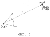
Фиг. 2 - иллюстрация обнаружения пожара в точке (xf, yf) из точки (х, у) с ошибкой Е;FIG. 2 - illustration of fire detection at point (x f , y f ) from point (x, y) with error E;
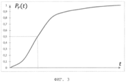
Фиг. 3 - график, иллюстрирующий обнаружительную способность алгоритма автоматического обнаружения пожара;FIG. 3 is a graph illustrating the detection ability of an automatic fire detection algorithm;
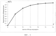
Фиг. 4 - график, иллюстрирующий обнаружительную способность системы;FIG. 4 is a graph illustrating the detection ability of a system;
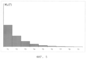
Фиг. 5 - график, иллюстрирующий плотность вероятности обнаружить пожар;FIG. 5 is a graph illustrating a probability density of detecting a fire;
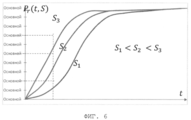
Фиг. 6 - график, иллюстрирующий зависимость обнаружительной способности от площади пожара;FIG. 6 is a graph illustrating the dependence of the detection ability on the area of the fire;
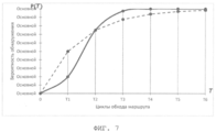
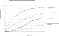
Фиг. 7 - график, иллюстрирующий зависимость вероятности обнаружения от времени наблюдения с учетом роста площади пожара (сплошная линия) и без учета роста площади пожара (пунктирная линия);FIG. 7 is a graph illustrating the dependence of the detection probability on the observation time, taking into account the growth of the fire area (solid line) and without taking into account the growth of the fire area (dashed line);
Фиг. 8 - логическая блок-схема способа оценки эффективности внедрения системы видеомониторинга леса;FIG. 8 is a logical flowchart of a method for evaluating the effectiveness of implementing a forest video monitoring system;
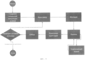
Фиг. 9 - логическая блок-схема гибридно эволюционно-генетического алгоритма поиска оптимальной конфигурации системы видеомониторинга леса;FIG. 9 is a logical block diagram of a hybrid evolutionary genetic algorithm for finding the optimal configuration of a forest video monitoring system;
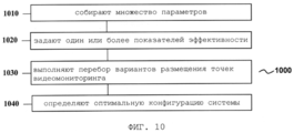
Фиг. 10 - логическая блок-схема способа определения оптимальной конфигурации системы видеомониторинга леса согласно настоящему изобретению;FIG. 10 is a flowchart of a method for determining an optimal configuration of a forest video monitoring system according to the present invention;
Фиг. 11 - иллюстрация обеспечения территории интереса вероятностью обнаружения не ниже заданной;FIG. 11 is an illustration of providing a territory of interest with a probability of detection not lower than a predetermined one;
Фиг. 12 - сравнение оптимального и неоптимального способов размещения видеокамер;FIG. 12 - comparison of the optimal and non-optimal ways of placing cameras;
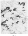
Фиг. 13 - иллюстрация территории с вероятностью обнаружения не менее заданной при неоптимальном расположении видеокамер, где места их установки отмечены треугольниками;FIG. 13 is an illustration of a territory with a probability of detection of at least given when the cameras are not optimally located, where their installation locations are marked with triangles;
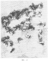
Фиг. 14 - иллюстрация территории с вероятностью обнаружения не менее заданной при оптимальном расположении видеокамер, где места их установки отмечены черными точками;FIG. 14 is an illustration of a territory with a probability of detection of at least given at the optimal location of the cameras, where their installation locations are marked with black dots;
Фиг. 15 - логическая блок-схема способа оценки показателей системы видеомониторинга леса при ее настройке в ходе эксплуатации;FIG. 15 is a logical flowchart of a method for evaluating indicators of a forest video monitoring system when it is set up during operation;
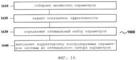
Фиг. 16 - логическая блок-схема способа оптимальной настройки системы видеомониторинга леса согласно настоящему изобретению.FIG. 16 is a flowchart of a method for optimally configuring a forest video monitoring system according to the present invention.
Подробное описание изобретенияDETAILED DESCRIPTION OF THE INVENTION
При последующем раскрытии настоящего изобретения будет делаться ссылка на систему 100 видеомониторинга леса по Фиг. 1, при этом описание данной системы в полной мере относится к раскрытию настоящего изобретения.In the subsequent disclosure of the present invention, reference will be made to the forest video monitoring system 100 of FIG. 1, while the description of this system fully relates to the disclosure of the present invention.
Общую постановку задачи оценки эффективности системы видеомониторинга леса целесообразно начать со следующего.It is advisable to start the general statement of the problem of assessing the effectiveness of the forest video monitoring system with the following.
Имеется достаточно большая территория, на которой только часть занимает область мониторинга (пример: лес покрывает только часть территории области). У территории есть специфичный рельеф, специфичные условия распространения оптического сигнала от обнаруживаемого объекта (условия окружающей среды), которые определяют характеристики процесса обнаружения объекта на территории. Предполагается, что для обнаружения пожара необходимо увидеть дым, поднимающийся над кромкой леса или непосредственно открытое пламя.There is a fairly large territory in which only a part of the monitoring area occupies (example: the forest covers only part of the region). The territory has a specific relief, specific conditions for the propagation of an optical signal from a detected object (environmental conditions), which determine the characteristics of the process of detecting an object in the territory. It is assumed that in order to detect a fire, it is necessary to see smoke rising above the edge of the forest or directly open flame.
Эффективность развернутой либо предполагаемой к развертыванию системы зависит от ее конфигурации: пространственного расположения точек видеомониторинга, параметров работы оборудования точек видеомониторинга (в частности, маршрута), способов обработки данных с точек и прочих параметров.The effectiveness of a system deployed or expected to be deployed depends on its configuration: the spatial location of the video monitoring points, the operation parameters of the equipment of the video monitoring points (in particular, the route), the methods of processing data from the points, and other parameters.
В формировании понятия эффективности задействуются параметры систем радиолокации (поскольку они близки по технологическому подходу к рассматриваемым системам оптической локации), принятые, например, в [1]. В силу того, что обнаруживаемый объект (лесной пожар) является практически неподвижным с точки зрения наблюдаемой территории, параметры, участвующие в определении эффективности работы системы, могут быть определены следующим образом:The formation of the concept of efficiency involves the parameters of radar systems (since they are close in technological approach to the considered optical location systems), adopted, for example, in [1]. Due to the fact that the detected object (wildfire) is practically motionless from the point of view of the observed area, the parameters involved in determining the efficiency of the system can be determined as follows:
- вероятность пропуска цели - вероятность того, что объект с заданными параметрами был на наблюдаемой территории, а система его не обнаружила. Система тем лучше, чем вероятность пропуска цели ниже;- probability of missing the target - the probability that the object with the given parameters was in the observed area, but the system did not find it. The system is better, the lower the probability of missing a target;
- вероятность ложной тревоги - вероятность выдачи сигнала наличия объекта при том, что объекта не было; обычно измеряется в значениях на единицу времени или в значениях на один анализируемый сигнал (объем информации). Система тем лучше, чем вероятность ложной тревоги ниже;- probability of false alarm - the probability of issuing an object presence signal despite the fact that the object was not; usually measured in values per unit time or in values per analyte signal (amount of information). The system is better, the lower the probability of false alarm;
- временное разрешение - время обнаружения, прошедшее с момента возникновения объекта до момента его обнаружения. Система тем лучше, чем время обнаружения меньше;- time resolution - the time of detection elapsed from the moment of occurrence of an object until its discovery. The better, the shorter the detection time;
- пространственное разрешение - точность определения координат обнаруженных объектов; если два объекта будут расположены рядом друг с другом, то на каком минимальном расстоянии они должны быть, чтобы система идентифицировала их как разные объекты. Система тем лучше, чем точность обнаружения выше, т.е. чем меньше ошибка определения координат.- spatial resolution - the accuracy of determining the coordinates of detected objects; if two objects are located next to each other, then at what minimum distance should they be for the system to identify them as different objects. The system is better, the higher the detection accuracy, i.e. the smaller the error in determining the coordinates.
Набор таких параметров может быть определен для каждой точки рассматриваемой территории и каждой конфигурации системы. Очевидно, что для фиксированной конфигурации системы (например, в ситуации, когда система уже развернута на местности) параметры, определенные для каждой из точек территории, будут различными. С другой стороны, в одной и той же точке местности определяемые параметры зависят от конфигурации системы, которая предполагается к развертыванию.A set of such parameters can be determined for each point of the territory under consideration and each system configuration. Obviously, for a fixed configuration of the system (for example, in a situation where the system is already deployed on the ground), the parameters defined for each of the points in the territory will be different. On the other hand, at the same point in the terrain, the determined parameters depend on the configuration of the system that is supposed to be deployed.
Поскольку под эффективностью работы системы подразумевается некоторое количество разнородных параметров, формализация понятия эффективности без принятия какого-либо механизма приведения видится крайне затруднительной. Для формализации понятий эффективности и оптимальности предлагается использовать обобщенный подход учета разнородных параметров через стоимостное выражение решения с соответствующими физическими характеристиками и потерь, допускаемых таким решением. Такой способ позволяет сделать свертку разнородных и часто противоречивых в математическом смысле физических параметров функционирования системы в естественный показатель эффективности.Since the effectiveness of a system implies a certain number of heterogeneous parameters, formalizing the concept of efficiency without adopting any reduction mechanism seems extremely difficult. To formalize the concepts of efficiency and optimality, it is proposed to use a generalized approach to taking into account heterogeneous parameters through the cost expression of the solution with the corresponding physical characteristics and losses allowed by such a solution. This method allows you to make a convolution of heterogeneous and often contradictory in the mathematical sense of the physical parameters of the functioning of the system in a natural indicator of effectiveness.
Очевидно, что поскольку для каждой точки территории определен набор физических характеристик, можно определить эффективность функционирования системы в точке территории. Общая же эффективность системы для территории может быть оценена как суммарная или средняя эффективность для всех точек данной территории.Obviously, since a set of physical characteristics is defined for each point of the territory, it is possible to determine the effectiveness of the functioning of the system at the point of the territory. The overall system efficiency for a territory can be estimated as the total or average efficiency for all points in a given territory.
Существует несколько факторов, обуславливающих сложность решения данной задачи:There are several factors that determine the difficulty of solving this problem:
1) Сложность физики процесса обнаружения. На факт обнаружения влияет множество объективных факторов:1) The complexity of the physics of the detection process. The fact of detection is influenced by many objective factors:
a. характеристики территории: рельеф, неоднородное покрытие территории лесом,a. Territory characteristics: relief, heterogeneous forest coverage,
b. погодные условия, меняющиеся во времени для разных участков рассматриваемой территории,b. weather conditions that change in time for different parts of the territory under consideration,
c. условия установки видеокамер: высота подвеса, особенности установки (например, загораживание конструкцией вышки части территории),c. installation conditions for cameras: suspension height, installation features (for example, blocking part of the territory with a tower structure),
d. влияние конкретных технических условий (ширина канала связи, особенности поворотной конструкции и объектива видеокамер, выбранные параметры функционирования камер и т.п.) на эффективность системы;d. the influence of specific technical conditions (communication channel width, features of the rotary structure and lens of video cameras, selected parameters of the cameras, etc.) on the efficiency of the system;
2) Организационная сложность. Определение степени влияния тех или иных факторов на эффективность требует большого количества статистических данных, которые часто не существуют в виде, готовом для учета в рамках рассматриваемой задачи, либо не существуют вообще ни в каком виде и должны быть собраны самостоятельно;2) Organizational complexity. Determining the degree of influence of certain factors on efficiency requires a large amount of statistical data, which often do not exist in a form that is ready for accounting within the framework of the problem under consideration, or do not exist at all in any form and must be collected independently;
3) Техническая сложность задачи. Реализация алгоритма решения излагаемой задачи сложна технически, а сам алгоритм очень ресурсоемок по следующим причинам:3) The technical complexity of the task. The implementation of the algorithm for solving the stated problem is technically complicated, and the algorithm itself is very resource intensive for the following reasons:
a. сложность вычисления упомянутых ранее физических параметров обнаружительной способности для точки территории. Вычисления сложны в смысле количества требуемых операций и учета большого количества данных;a. the difficulty of calculating the previously mentioned physical parameters of the detection ability for a point in the territory. The calculations are complex in terms of the number of operations required and the accounting for a large amount of data;
b. размерность задачи, порождаемая размерами территории. Как было сказано, общая эффективность системы может быть оценена как средняя в некотором смысле эффективность по всем точкам территории. Для получения адекватной оценки количество учитываемых точек должно быть порядка 106, т.е. должно быть сделано порядка 106 вычислений по пункту 3а.b. dimension of the problem generated by the size of the territory. As was said, the overall effectiveness of the system can be estimated as average in a sense, the effectiveness of all points of the territory. To obtain an adequate estimate, the number of points taken into account must be of the order of 10 6 , i.e. about 10 6 calculations according to paragraph 3a should be done.
Наличие упомянутых факторов сложности заставляет разрабатывать упрощенные модели учета различных факторов, эффективные вычислительные процедуры [3], [4], в том числе с использованием суперкомпьютерных технологий и специального оборудования [5], что является отдельной сложной технической проблемой.The presence of the mentioned complexity factors makes it necessary to develop simplified models for accounting for various factors, effective computational procedures [3], [4], including using supercomputer technologies and special equipment [5], which is a separate complex technical problem.
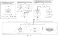
Рассмотрение задачи оценки эффективности конфигурации системы видеомониторинга леса проводится в нотации, определяющей блоки данных (входных, выходных, промежуточных) и обрабатывающие блоки, производящие вычисления над данными.Consideration of the problem of assessing the effectiveness of the configuration of a forest video monitoring system is carried out in a notation that defines data blocks (input, output, intermediate) and processing blocks that perform calculations on the data.
Во входных блоках данных размещается следующая структурированная информация.The following structured information is placed in the input data blocks.
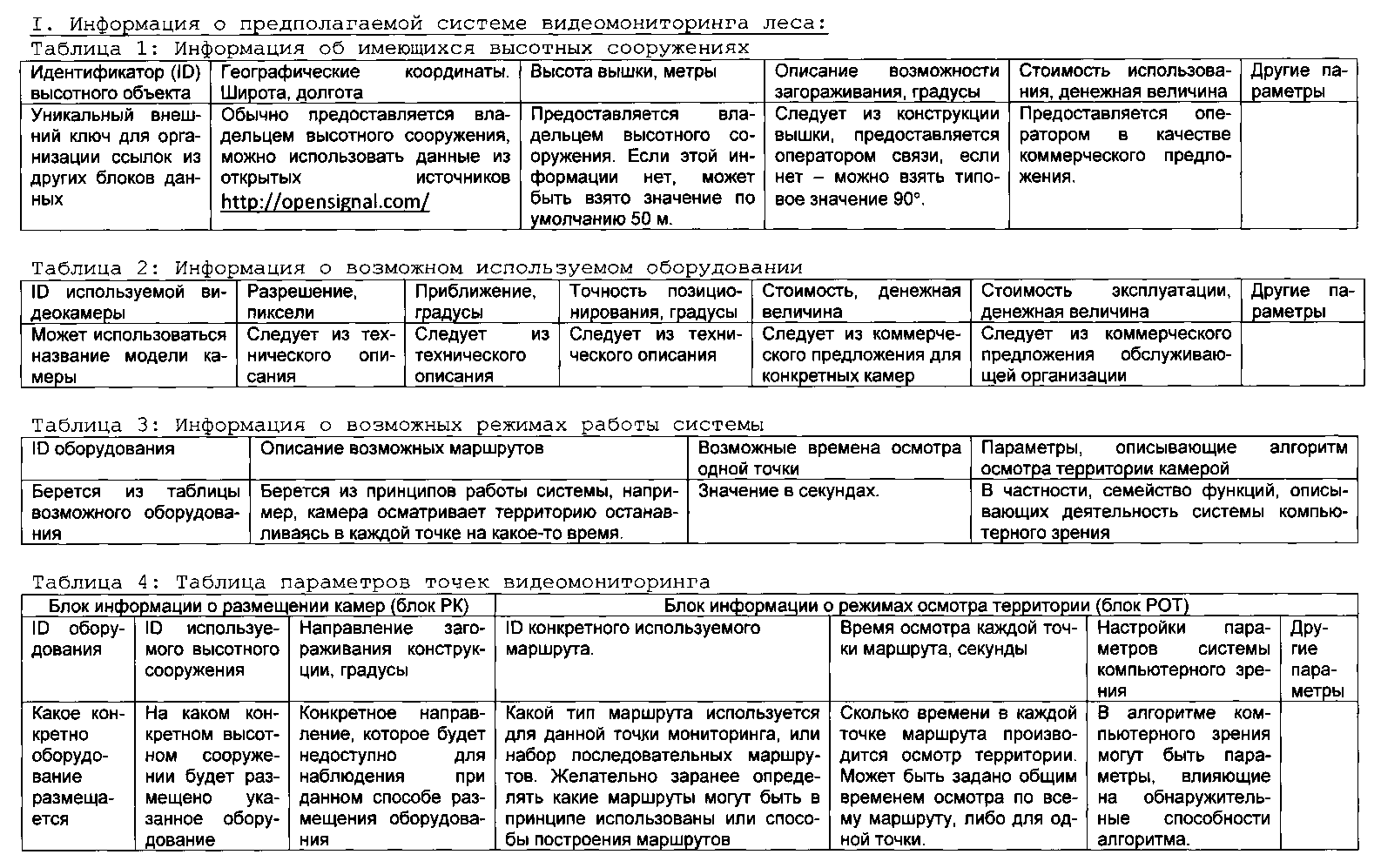
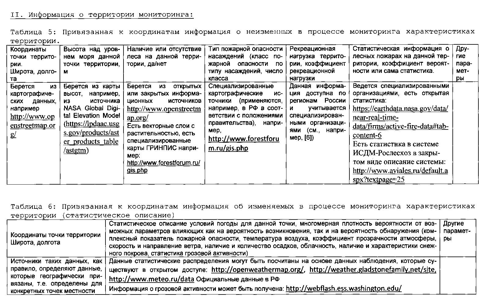
Наиболее важным моментом является определение основных функций, необходимых для оценки эффективности, и зависимостей между такими функциями. Подробнее остановимся на примерах способов расчета таких функций, а также на источниках данных для статистических зависимостей. Важным фактором является вычислительная сложность указанных функций для реальных условий применения.The most important point is the determination of the basic functions necessary for evaluating the effectiveness, and the dependencies between such functions. Let us dwell in more detail on examples of methods for calculating such functions, as well as on data sources for statistical dependencies. An important factor is the computational complexity of these functions for real-world application conditions.
Наиболее сложными и принципиальными являются оценка вероятности обнаружения пожара системой и зависимость потерь, связанных с нетушением пожара, от времени его обнаружения.The most complex and fundamental are the assessment of the probability of detection of a fire by the system and the dependence of losses associated with fire extinguishing from the time of its detection.
1. Оценка вероятности обнаружения пожара1. Assessment of the probability of fire detection
Пусть камера подвешена в точке с координатами х, y и высотой h, а точка, в которой нас интересует оценка вероятности обнаружить пожар, имеет координаты xf, yf (назовем ее точкой интереса). Для рассматриваемой точки интереса дан тип леса, определяющий скорость распространения пожара. Расстояние r между точкой интереса и точкой наблюдения может быть легко вычислено. Рельеф местности определяет оптическую видимость между этими двумя точками. Кроме того, в момент наблюдения заданы основные внешние параметры: прозрачность атмосферы (дальность видимости), скорость ветра, класс пожарной опасности. Предположим, что камера осматривает территорию вокруг себя с определенным углом обзора по горизонтали и в каждом направлении снимает в течение времени t.Let the camera be suspended at a point with coordinates x, y and height h, and the point at which we are interested in assessing the probability of detecting a fire has coordinates x f , y f (let's call it the point of interest). For the point of interest in question, a forest type is given that determines the speed of fire spread. The distance r between the point of interest and the observation point can be easily calculated. The terrain determines the optical visibility between these two points. In addition, at the time of observation, the main external parameters were set: atmospheric transparency (visibility range), wind speed, fire hazard class. Suppose that a camera inspects the area around it with a certain horizontal viewing angle and takes pictures in each direction over time t.
На Фиг. 2 схематично представлена данная ситуация. Предположим, что пожар начинается в нулевой момент времени, и, поскольку даны условия распространения (тип насаждений, класс пожарной опасности, скорость ветра), на основе табличных данных может быть определено, как будет меняться площадь пожара от времени [8].In FIG. 2 schematically presents this situation. Suppose that a fire starts at time zero, and since propagation conditions are given (planting type, fire hazard class, wind speed), based on tabular data, it can be determined how the fire area will change over time [8].
Важные предположения: время съемки каждой точки много меньше времени, за которое пожар значительно увеличивается в размерах, т.е. можно считать, что во время съемки в данном направлении пожар не меняет своего размера. За время между съемками одной точки (камера по заданным маршрутам обходит территорию и повторно снимает то же направление) не меняются внешние условия (прозрачность, скорость ветра и т.д.), но при этом считается, что каждый следующий осмотр - это событие, независимое в терминах обнаружительной способности системы от предыдущей съемки в том же направлении.Important assumptions: the shooting time of each point is much shorter than the time during which the fire significantly increases in size, i.e. we can assume that during shooting in this direction the fire does not change its size. During the time between surveys of one point (the camera traverses the territory along the given routes and re-takes the same direction) the external conditions (transparency, wind speed, etc.) do not change, but it is considered that each subsequent inspection is an independent event in terms of system detectability from a previous survey in the same direction.
Для того, чтобы построить плотность вероятности обнаружить пожар от времени, нужно определить, как вероятность зависит от времени наблюдения за точкой интереса. При построении системы, направленной на автоматическое определение источника возгорания, эта зависимость также определяется характеристикой алгоритма автоматического обнаружения. Данную зависимость можно получить на основе статистических исследований, используя готовые видеоматериалы, содержащие изображения пожаров при определенных условиях, путем запуска в отношении них алгоритма автоматического обнаружения дыма. Поскольку накопление развитой базы видеоматериалов с различными характеристиками пожаров и условий обнаружения может быть проблемой в связи с редкостью природного пожара как явления, можно смоделировать, как будет выглядеть дым при определенных условиях на изображении и провести исследования используемого алгоритма автоматического обнаружения на моделируемых видеоматериалах.In order to build the probability density to detect a fire from time to time, it is necessary to determine how probability depends on the time of observation of the point of interest. When constructing a system aimed at automatically determining the source of ignition, this dependence is also determined by the characteristic of the automatic detection algorithm. This dependence can be obtained on the basis of statistical studies, using ready-made video materials containing images of fires under certain conditions, by running an automatic smoke detection algorithm for them. Since the accumulation of a developed base of video materials with different characteristics of fires and detection conditions can be a problem due to the rarity of a natural fire as a phenomenon, we can simulate how smoke will look under certain conditions in the image and conduct research on the algorithm used for automatic detection on simulated video materials.
Пример графика зависимости вероятности обнаружения пожара в точке территории от времени непрерывной съемки в данной позиции приведен на Фиг. 3. Еще раз уточним, что это есть зависимость вероятности обнаружения пожара для конкретной точки наблюдаемой территории от времени непрерывного наблюдения за этой точкой при условии, что пожар в этой точке присутствует и фиксированы параметры окружающей среды, размеры пожара, конкретное приближение камеры и конкретное местоположение пожара относительно камеры (в смысле рельефа и дальности).An example of a graph of the probability of detecting a fire at a point in the territory versus the time of continuous shooting at a given position is shown in FIG. 3. Once again, we clarify that this is the dependence of the probability of fire detection for a particular point of the observed area on the time of continuous observation of this point, provided that the fire is present at this point and the environmental parameters, the size of the fire, the specific proximity of the camera and the specific location of the fire are fixed relative to the camera (in terms of terrain and range).
Используя данную зависимость и предположение, что пожар возникает в случайные моменты времени, а так же предположение, что между соседними по времени осмотрами данной территории проходит столько времени, что обнаружение при повторном осмотре в статистическом смысле не зависит от обнаружения при первом, можно построить вероятность обнаружения пожара от времени с момента его возникновения (Фиг. 4). По оси абсцисс отложены времена, за которые камера делает 1, 2, 3 и т.д. оборотов или, другими словами, возвращается для повторного осмотра данной территории. Следует пояснить, что поскольку поворотная камера поочередно снимает позиции, заданные маршрутом, вероятность того, что камера к моменту времени Т на отрезке [0, T1] сняла именно точку (xf, yf), линейно зависит от Т, достигая 1 в момент T1. Действительно, поскольку T1 - время совершения полного цикла осмотра по маршрутам, вероятность того, что конкретная точка территории будет к этому моменту осмотрена, равна 1, так как к этому моменту будут сняты все точки территории интереса. Поскольку вероятность обнаружения пожара в точке является произведением вероятности осмотра точки за время Т на вероятность обнаружения пожара на отснятом материале, вероятность обнаружения пожара в момент времени T1 равна 1*Pr(t). Для выбранного на Фиг. 4 времени осмотра одной точки вероятность обнаружения к моменту T1 составит 0.5. К моменту времени Т2 территория будет осмотрена дважды, и это значит, что вероятность обнаружить пожар будет 1-(1-Pr(t))2. Между точками Ti и Ti+1 функция вероятности определена линейно. Продолжая процедуру в сторону увеличения времени, получим зависимость вероятности обнаружения пожара в точке территории от времени функционирования системы.Using this dependence and the assumption that a fire occurs at random points in time, as well as the assumption that so much time passes between neighboring inspections of a given territory that detection during a second inspection in a statistical sense does not depend on detection at the first, we can build the probability of detection fire from time from the moment of its occurrence (Fig. 4). The abscissa shows the times for which the camera makes 1, 2, 3, etc. revolutions or, in other words, is returned for re-inspection of the territory. It should be clarified that since the PTZ camera takes off the positions set by the route one by one, the probability that the camera at the time point T on the segment [0, T 1 ] has taken exactly the point (x f , y f ) linearly depends on T, reaching 1 in moment T 1 . Indeed, since T 1 is the time for the complete inspection cycle along the routes, the probability that a particular point in the territory will be inspected at this point is 1, since by that moment all points of the territory of interest will be taken. Since the probability of detecting a fire at a point is the product of the probability of inspecting the point during time T and the probability of detecting a fire on the footage, the probability of detecting a fire at time T 1 is 1 * P r (t). For the one selected in FIG. 4 times of inspection of one point, the probability of detection at time T 1 will be 0.5. By the time T 2, the territory will be inspected twice, and this means that the probability of detecting a fire will be 1- (1-P r (t)) 2 . Between points T i and T i + 1 , the probability function is defined linearly. Continuing the procedure in the direction of increasing time, we obtain the dependence of the probability of detecting a fire at a point in the territory on the time the system operates.
Для получения плотности вероятности обнаружить пожар в определенный момент времени с момента его возникновения необходимо численно взять производную от вероятности обнаружения по времени. Пример такой плотности вероятности представлен на Фиг. 5. Фактически это и есть искомая плотность вероятности обнаружить пожар от времени Wобн (см. формулу (4) ниже) для системы, которая состоит из одной камеры.To obtain the probability density of detecting a fire at a certain point in time from the moment of its occurrence, it is necessary to take numerically the derivative of the probability of detection over time. An example of such a probability density is shown in FIG. 5. In fact, this is the desired probability density for detecting a fire from the time W obn (see formula (4) below) for a system that consists of one camera.
Приведенные выше рассуждения были сделаны исходя их предположения, что за время наблюдения размеры пожара не меняются. В реальной же обстановке период полного прохождения маршрута осмотра территории измеряется десятками минут или даже часами. С учетом того, что пожар может быть обнаружен на втором, третьем и т.д. проходе маршрута наблюдения, его размер к этому моменту может существенно увеличиться, что повысит вероятность его обнаружения. Зависимость площади пожара от времени может быть оценена на основе табличных данных, приводимых в различных методических пособиях (например, в [7]). Вероятность обнаружить пожар увеличивается с увеличением его площади, и, как следствие, видимого размера. Этот факт проиллюстрирован на Фиг. 6, где изображено семейство кривых вероятности обнаружения пожара в зависимости от времени съемки одной позиции маршрута для трех различных площадей пожара.The above reasoning was made on the basis of their assumption that during the observation the size of the fire does not change. In real conditions, the period of the complete passage of the route of inspection of the territory is measured in tens of minutes or even hours. Given that a fire can be detected on the second, third, etc. passage of the observation route, its size by this moment can significantly increase, which will increase the likelihood of its detection. The dependence of the fire area on time can be estimated on the basis of tabular data given in various teaching aids (for example, in [7]). The probability of detecting a fire increases with an increase in its area, and, as a result, its apparent size. This fact is illustrated in FIG. 6, which depicts a family of probability curves for fire detection as a function of the time taken for one route position for three different areas of fire.
Пусть известна зависимость площади пожара от времени его горения S(T). Тогда, повторяя рассуждения для Фиг. 4, получим, что вероятность обнаружить пожар в момент времени Т1 равна Pr(t,S(T1)), в момент времени Т2 равна 1-(1-Pr(t,S(Т1))) (1-Pr(t,S(T2))) и т.д. Значения Р(Т) в точках, отличных от Ti могут быть вычислены по формуле (1), которая отражает тот факт, что вероятность обнаружить пожар зависит не только от обнаружительной способности алгоритма при выбранном времени съемки одной позиции t, но и от вероятности осмотреть точку интереса i раз к моменту времени Т. Плотность вероятности посмотреть в точку интереса i раз ко времени Т 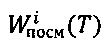
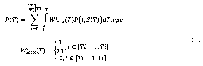
Эти факты проиллюстрированы на Фиг. 7. Для ясности, на Фиг. 7 пунктирной линией приведена зависимость вероятности обнаружения без учета роста площади очага возгорания при некотором фиксированном его размере.These facts are illustrated in FIG. 7. For clarity, in FIG. 7, the dashed line shows the dependence of the probability of detection without taking into account the increase in the area of the fire source at a certain fixed size.
Рассмотрим более общий случай, когда данная точка территории видна сразу с нескольких камер. Приведем пример для двух камер, после чего поясним, как распространить приводимые рассуждения на любое количество видеокамер.Let us consider a more general case when a given point of the territory is visible from several cameras at once. We give an example for two cameras, after which we will explain how to extend the given reasoning to any number of cameras.
Пусть есть две точки видеомониторинга, каждая из которых имеет свою высоту, находится на своем расстоянии от точки наблюдения, каждая проводит мониторинг со своими параметрами (угол обзора, время наблюдения точки, параметры алгоритма), условия окружающей среды могут быть одинаковыми или разными. Тогда для каждой из точек будет своя вероятность обнаружить пожар от времени, соответственно P1(T) и Р2(Т), и вероятность обнаружить за время Т хотя бы с одной камеры будет определяться по следующей формуле:Suppose there are two video monitoring points, each of which has its own height, is located at its own distance from the observation point, each carries out monitoring with its own parameters (viewing angle, point observation time, algorithm parameters), environmental conditions can be the same or different. Then for each of the points there will be its own probability of detecting a fire from time to time, P 1 (T) and P 2 (T), respectively, and the probability of detecting a time T at least from one camera will be determined by the following formula:

Проведя дифференцирование этой функции, можно получить плотность вероятности обнаружить пожар хотя бы с одной видеокамеры от времени. Данный способ позволяет определять плотность вероятности от времени при наблюдении точки территории любым количеством точек видеомониторинга, исходя из соображения, что вероятность обнаружения хотя бы одной точкой видеомониторинга обратна вероятности необнаружения одновременно всеми точками видеомониторинга:Having differentiated this function, it is possible to obtain the probability density to detect a fire from at least one video camera from time to time. This method allows you to determine the probability density over time when observing a territory point with any number of video monitoring points, based on the consideration that the probability of detection by at least one video monitoring point is the reverse of the probability of non-detection by all video monitoring points simultaneously:

2. Расчет точности определения координат2. The calculation of the accuracy of determining the coordinates
Точность определения координат возгорания в точке интереса (xf, yf) с видеокамеры в точке (х, у) зависит от взаимного расположения точки интереса и камеры и не зависит от времени наблюдения. Точность определения координат может быть охарактеризована вероятностью определения в точке (xf, yf) координат пожара с ошибкой Е Рошибки(Е) с условием, что точка была просмотрена и в ней был пожар. Однако, если учесть данные на Фиг. 7, то вероятность обнаружить пожар, при условии, что он был в точке интереса, равна произведению вероятности реализации ошибки Е на вероятность обнаружить в этой точке пожар ко времени Т:The accuracy of determining the coordinates of the fire at the point of interest (x f , y f ) from the video camera at the point (x, y) depends on the relative position of the point of interest and the camera and does not depend on the time of observation. The accuracy of determining the coordinates can be characterized by the probability of determining at the point (x f , y f ) the coordinates of the fire with error E P errors (E) provided that the point was viewed and there was a fire in it. However, given the data in FIG. 7, then the probability of detecting a fire, provided that it was at a point of interest, is equal to the product of the probability of the implementation of error E and the probability of detecting a fire at this point by time T:

При этом для двух камер функция реализации ошибки должна выглядеть следующим образом:Moreover, for two cameras, the error implementation function should look like this:

где 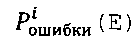

Рассуждения, относящиеся к формуле (4), можно распространить на сколь угодно большое количество видеокамер. Из полученной записи плотности вероятности очевидным способом получается плотность вероятности реализации ошибки Е в момент времени Т для конкретной точки территории 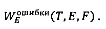
3. Зависимость потерь, связанных с нетушением пожара, от времени его обнаружения3. The dependence of losses associated with fire extinguishing, from the time of its detection
Зависимость должна включать компоненты ущерба, связанные с продолжительностью нетушения пожара (в том числе, связанные со временем обнаружения, точностью определения местоположения пожара, стоимостью тушения (например, в соответствии с [9]) и т.д.).The dependence should include damage components related to the duration of the fire extinguishing (including those related to the time of detection, the accuracy of determining the location of the fire, the cost of extinguishing (for example, in accordance with [9]), etc.).
Очевидным является предположение, что ущерб зависит от площади пожара, которая, в свою очередь, увеличивается от времени, т.е. чем большую площадь "прошел" пожар, тем больше должен быть ущерб. После определения зависимости ущерба, наносимого пожаром, от площади и зная, как меняется площадь от времени, может быть оценена зависимость стоимости тушения от времени. В данной зависимости также может быть учтено то, что время, требуемое для того, чтобы доехать до каждой точки территории, будет разным, т.е. добавится еще компонента, определяющая прибавку во времени нетушения пожара в зависимости от места его возникновения.The assumption is obvious that the damage depends on the area of the fire, which, in turn, increases with time, i.e. the larger the area "passed" the fire, the greater the damage should be. After determining the dependence of the damage caused by the fire on the area and knowing how the area varies with time, the dependence of the cost of extinguishing on time can be estimated. In this dependence, it can also be taken into account that the time required to reach each point of the territory will be different, i.e. another component will be added, which will determine the increase in the time of extinguishing the fire, depending on the place of its occurrence.
В конечном счете, ущерб зависит от того, какова стала площадь пожара к моменту начала тушения, которая, в свою очередь, зависит от того, в какое время после начала горения пожар был обнаружен и какова была точность определения координат. Простая интерпретация зависимости площади пожара от точности определения координат заключается в том, что при неточном определении пожарной бригаде придется осуществлять поиск пожара на местности, на что уйдет время, зависящее от ошибки определения координат, и за это время пожар увеличится в размерах. Эти рассуждения выражены следующей формулой:Ultimately, the damage depends on what the area of the fire became by the time the fire was extinguished, which, in turn, depends on what time after the start of the fire the fire was detected and what the accuracy of determining the coordinates was. A simple interpretation of the dependence of the fire area on the accuracy of determining the coordinates is that if the fire brigade is inaccurate, it will be necessary to search for the fire on the ground, which will take time, depending on the error in determining the coordinates, and during this time the fire will increase in size. These considerations are expressed by the following formula:

где C(S) - зависимость ущерба, нанесенного пожаром от его площади, S(T) - зависимость площади пожара от времени, tнахождения (E) - зависимость времени нахождения пожара бригадой в зависимости от ошибки обнаружения Е.where C (S) is the dependence of the damage caused by the fire on its area, S (T) is the dependence of the area of the fire on time, t location (E) is the dependence of the time the fire spent on the brigade depending on the detection error E.
В таком случае, оценкой среднего ущерба, допущенного системой обнаружения в точке интереса F при конкретных характеристиках окружающей среды К и при условии, что в данной точке был пожар, будетIn this case, the average damage caused by the detection system at the point of interest F with specific environmental characteristics K and provided that there was a fire at this point will be an estimate

Таким образом, полная запись оценки среднего ущерба для всей территории при заданной плотности вероятности возникновения определенных условий окружающей среды Wокр и вероятности возникновения пожара в точке F при условиях окружающей среды К Wпожаpa(F,K) будет такой:Thus, a complete record of the average damage assessment for the entire territory at a given probability density of the occurrence of certain environmental conditions W okr and the probability of a fire at point F under environmental conditions K W fire (F, K) will be as follows:

Следует отметить, что Рпожара нормирована по времени, т.е. имеет смысловое значение "вероятность возникновения пожара за определенный период времени". Поэтому оценка среднего ущерба нормирована по времени в том же смысле, т.е. имеет смысл "средний ущерб, допущенный системой обнаружения, за период времени".It should be noted that P fire is normalized in time, i.e. meaning "the probability of a fire for a certain period of time." Therefore, the average damage assessment is normalized over time in the same sense, i.e. it makes sense "average damage caused by the detection system over a period of time."
Кроме того, следует рассмотреть еще ряд критериев, которые могут использоваться для оценки эффективности системы видеомониторинга леса.In addition, a number of criteria that can be used to evaluate the effectiveness of the forest video monitoring system should be considered.
Средняя вероятность обнаружения пожара за время Т:Average probability of fire detection during time T:

Среднее время с вероятностью Р обнаружить пожар:Average time with probability P to detect a fire:

Средняя вероятность обнаружить за время Т пожар с ошибкой не больше Е:The average probability of detecting a fire during time T with an error of no more than E:

Отметим, что формула (10) позволяет отвечать на вопросы следующего характера:Note that formula (10) allows you to answer questions of the following nature:
1) Какова средняя вероятность за время Т обнаружить пожар с точностью Е;1) What is the average probability over time T to detect a fire with accuracy E;
2) При построении обратной функции по Т: каково среднее время, затраченное на обнаружение пожара с заданной точностью и вероятностью не менее заданной величины;2) When constructing the inverse function with respect to T: what is the average time taken to detect a fire with a given accuracy and probability of at least a given value;
3) При построении обратной функции по Е: при заданной вероятности с какой точностью можно определить координаты возгорания за время Т.3) When constructing the inverse function with respect to E: for a given probability with what accuracy it is possible to determine the coordinates of ignition during time T.
Здесь целесообразно сделать замечание по поводу учета далеких вышек. Очевидно, что точность определения координат с одной камеры и, как следствие, вклад в точность определения координат при обнаружении с нескольких камер, убывает по мере увеличения расстояния между камерой и точкой интереса. Кроме того, при увеличении расстояния вероятность обнаружения также снижается. Эти факты позволяют утверждать, что при достижении некоторого порога расстояния между камерой и точкой интереса вклад камеры в обнаружительные характеристики системы для конкретной точки территории становится пренебрежимо малым. Это означает, что вычислительная сложность расчетных процедур при оценке обнаружительных характеристик системы может быть снижена путем исключения из рассмотрения камер, находящихся дальше заданного порога от точки интереса.It is advisable to make a remark about the accounting of distant towers. Obviously, the accuracy of determining coordinates from a single camera and, as a consequence, the contribution to the accuracy of determining coordinates when detected from multiple cameras, decreases with increasing distance between the camera and the point of interest. In addition, as the distance increases, the probability of detection also decreases. These facts suggest that when a certain threshold is reached between the camera and the point of interest, the contribution of the camera to the detection characteristics of the system for a particular point in the territory becomes negligible. This means that the computational complexity of the calculation procedures in assessing the detection characteristics of the system can be reduced by excluding from consideration cameras that are beyond a predetermined threshold from the point of interest.
4. Расчет экономической эффективности внедрения системы обнаружения пожара4. Calculation of the cost-effectiveness of implementing a fire detection system
Введем понятие полного ущерба при эксплуатации системы обнаружения. Полный ущерб складывается из:We introduce the concept of total damage during the operation of the detection system. Full damage consists of:
1. среднего ущерба 
2. разовых затрат на разворачивание системы Сразворачивание,2. one-time deployment costs of the system With deployment ,
3. эксплуатационных затрат Сэксплуатации: аренды площадок размещения оборудования, каналов связи, обслуживания системы за рассматриваемый период времени,3. operating costs From operation : leasing of equipment placement sites, communication channels, system maintenance for the considered period of time,
4. затрат на человеческие ресурсы (операторов системы) Соператоры.4. human resource costs (system operators) With operators .
Экономическую эффективность внедрения можно рассчитывать как разницу между потенциальным полным ущербом (пункты 1-4) после внедрения системы и потенциальным полным ущербом (пункты 1, 3, 4) при невнедрении за интересующий период времени. Такой подход учитывает сценарии, когда существующая система обнаружения заменяется на более новую либо система видеомониторинга внедряется на территории, где ранее отсутствовала какая-либо иная система обнаружения. Так, оценка полного ущерба существующей системы складывается из пунктов 1, 3, 4, а при отсутствии системы - только из пункта 1. В таком случае подход, определяемый формулой (6), может быть также применен с необходимым уточнением, что плотность вероятности обнаружить пожар представляет собой дельта-функцию с "пиком" в месте, определяющем максимальный урон от пожара, а плотность вероятности реализации точности определения координат Е - дельта-функция с пиком, соответствующим вероятности возникновения ошибки определения координат 0.The economic efficiency of implementation can be calculated as the difference between the potential total damage (paragraphs 1-4) after the introduction of the system and the potential total damage (
Сразворачивание должна быть посчитана исходя из определения стоимости используемого оборудования и его монтажа.With the deployment should be calculated based on the determination of the cost of the equipment used and its installation.
Соператоры должна быть посчитана исходя из средней стоимости работы оператора в данной местности и количества операторов, необходимого для обслуживания системы с учетом сменности. Необходимое количество операторов может быть оценено по следующей методике. Известно среднее число F фактов съемки камеры в единицу времени. В реальности это число составляет 1,5-2 факта в минуту. Известно количество камер в предполагаемой системе N. Очевидно, что вся система камер будет генерировать F×N экземпляров видеоматериала в единицу времени. Система автоматического обнаружения допускает вероятность ложного срабатывания Pfault, следовательно, среднее количество ложных срабатываний в единицу времени во всей системе будет F×N×Pfault. Это есть оценка среднего количества требующих принятия оператором решения видеоматериалов, генерируемых системой в единицу времени. Строго говоря, принятия решения требуют не только видеоматериалы, на которых алгоритм допустил ложное срабатывание, но и те, на которых алгоритм сработал верно, но число последних зависит от числа пожаров на местности за единицу времени и несоизмеримо мало по сравнению с числом ложных срабатываний, что позволяет пренебречь этим компонентом при оценке нагруженности оператора. Известно, что оператор в среднем способен принять решения по S видеоматериалам в единицу времени (типичный показатель 10-20 фактов в минуту). Отсюда минимально необходимое потребное количество операторов может быть оценено следующим образом:C operators should be calculated based on the average cost of the operator’s work in a given area and the number of operators needed to service the system, taking into account shift. The required number of operators can be estimated using the following procedure. The average number F of camera shooting facts per unit time is known. In reality, this number is 1.5-2 facts per minute. The number of cameras in the proposed system N is known. Obviously, the entire camera system will generate F × N instances of video material per unit time. The automatic detection system allows the probability of a false positive P fault , therefore, the average number of false positives per unit time in the whole system will be F × N × P fault . This is an estimate of the average number of videos required by the operator to make decisions generated by the system per unit time. Strictly speaking, decision making requires not only video materials on which the algorithm allowed a false positive, but also those on which the algorithm worked correctly, but the number of the latter depends on the number of fires on the ground per unit time and is incommensurably small compared to the number of false positives, which allows to neglect this component when assessing the operator load. It is known that the operator on average is able to make decisions on S video materials per unit time (a typical indicator of 10-20 facts per minute). Hence, the minimum required number of operators can be estimated as follows:

где К>1 - коэффициент резерва, D - длительность смены одного оператора в часах.where K> 1 is the reserve ratio, D is the duration of the shift of one operator in hours.
Кроме того, оценка может учитывать, что в периоды пожарной опасности регламент мониторинга территории, помимо просмотров результатов деятельности автоматической системы, может включать непосредственный осмотр территории человеком. Для таких периодов оценка может быть пересмотрена следующим образом:In addition, the assessment may take into account that during periods of fire danger, the regulation for monitoring the territory, in addition to viewing the results of the automatic system, may include a direct inspection of the territory by a person. For such periods, the estimate may be revised as follows:

Вычисление затрат на операторов является очевидной процедурой при известном необходимом их числе и средней стоимости работника необходимой квалификации в данной местности.Calculation of costs for operators is an obvious procedure with the known required number and the average cost of an employee of the necessary qualifications in a given area.
Ниже со ссылкой на Фиг. 8 описан способ определения ущерба, допущенного системой видеомониторинга леса. Как видно, описываемый способ оценки эффективности системы состоит из четырех блоков.Below with reference to FIG. 8 describes a method for determining damage caused by a forest video monitoring system. As you can see, the described method for evaluating the effectiveness of the system consists of four blocks.
Блок {1}, на основе статистической обработки архивных данных о погоде в данной территории (Таблица 6 (Т6)), вычисляет прогнозную вероятность возникновения пожара на данной территории за рассматриваемый период времени Рпожара и плотности вероятности реализации конкретных условий окружающей среды Wокр(K). Следует отметить, что прогнозная вероятность возникновения пожара может быть оценена как на основе архивных данных о пожарах на территории в пожароопасные сезоны, так и с использованием различных методик прогноза вероятности возникновения пожара на основе предполагаемых классов пожарной опасности с учетом возможной погодной обстановки на территории.Block {1}, based on statistical processing of archived weather data in a given territory (Table 6 (Т6)), calculates the predicted probability of a fire in a given territory for the considered period of time P of fire and the probability density of the implementation of specific environmental conditions W okr (K ) It should be noted that the predicted probability of a fire can be estimated both on the basis of archival data on fires in the territory during the fire hazard seasons, and using various methods for predicting the probability of a fire based on the expected fire hazard classes taking into account the possible weather conditions in the territory.
Блок {2} строит функцию С(Т,Е) оценки зависимости ущерба, нанесенного пожаром, от времени нетушения пожара и ошибки определения его координат (см. формулу (5)). Зависимость строится на основе:Block {2} constructs a function C (T, E) for assessing the dependence of the damage caused by the fire on the time of the fire not being extinguished and the error in determining its coordinates (see formula (5)). Dependence is based on:
1) данных о зависимости площади пожара от времени (другими словами, данных о скорости распространения пожара для леса на конкретной территории),1) data on the dependence of the fire area on time (in other words, data on the speed of fire spread for the forest in a specific territory),
2) данных о стоимости леса на единицу площади лесного покрова,2) data on the value of the forest per unit area of forest cover,
3) данных о времени нахождения очага возгорания силами тушения при определенной допущенной системой ошибке обнаружения координат возгорания.3) data on the time spent by the fire extinguishing site for a fire at a certain error detected by the system for detecting the coordinates of the fire.
Блок {3}, на основе данных из Таблиц 1-6 (Т1-Т6), в соответствии с подходами, описанными выше в разделах 1, 2, и с использованием формул (1), (3), строит процедуру вычисления следующих фундаментальных обнаружительных характеристик системы для каждой точки исследуемой территории:Block {3}, based on the data from Tables 1-6 (T1-T6), in accordance with the approaches described above in
1) плотность вероятности обнаружить пожар за определенное время Т в данной точке интереса F при реализации конкретных погодных условий К;1) the probability density to detect a fire for a certain time T at a given point of interest F in the implementation of specific weather conditions K;
2) плотность вероятности допустить ошибку определения координат Е при наблюдении очага в точке интереса F в течение времени Т.2) the probability density to make a mistake in determining the coordinates of E when observing the focus at the point of interest F during time T.
Блок {4}, в соответствии с подходами, описанными выше в разделах 3, 4 строит серию оценочных критериев для системы, таких как:Block {4}, in accordance with the approaches described in sections 3, 4 above, constructs a series of evaluation criteria for the system, such as:
1) полный ущерб, допущенный системой, который включает не только ущерб, связанный с потерей леса, но и стоимость разворачивания и обслуживания самой системы;1) the total damage incurred by the system, which includes not only damage associated with the loss of forest, but also the cost of deployment and maintenance of the system itself;
2) вероятностные, точностные и временные характеристики системы, включая среднюю вероятность обнаружения пожара за время Т, среднее время с вероятностью Р обнаружить пожар, среднюю вероятность обнаружения пожара за время Т с ошибкой не больше Е.2) the probability, accuracy and time characteristics of the system, including the average probability of fire detection during time T, the average time with probability P to detect a fire, the average probability of fire detection during time T with an error of no more than E.
Далее описывается способ оптимального размещения системы видеомониторинга леса для раннего обнаружения пожаров.The following describes a method for optimally deploying a forest video monitoring system for early fire detection.
Очевидным является факт, что системы видеомониторинга леса с разными конфигурациями обеспечивают разные обнаружительные характеристики и, как следствие, разную величину полного ущерба для рассматриваемой территории. Поэтому, при подготовке к развертыванию важным является не столько априорная оценка характеристик системы на местности, сколько выбор оптимальной конфигурации, которая бы удовлетворяла всем наложенным на систему ограничениям и имела оптимальные оценки по выбранным критериям.It is an obvious fact that forest video monitoring systems with different configurations provide different detection characteristics and, as a result, different amounts of total damage to the territory under consideration. Therefore, in preparation for deployment, it is important not so much an a priori assessment of the system characteristics on the ground, but rather the choice of the optimal configuration that would satisfy all the restrictions imposed on the system and have optimal estimates according to the selected criteria.
Для описания способа выбора оптимальной конфигурации системы перечислим варьируемые параметры, варианты ограничений и критериев.To describe the method of choosing the optimal system configuration, we list the variable parameters, options for restrictions and criteria.
Варьируемые параметрыVariable Parameters
В качестве варьируемых параметров выступают данные, приведенные в Таблице 4, а именно:As the variable parameters are the data shown in Table 4, namely:
- места расположения видеокамер (могут выбираться из заранее заданного списка, либо произвольно);- the location of the cameras (can be selected from a predetermined list, or randomly);
- типы оборудования;- types of equipment;
- конфигурации маршрутов осмотра;- configuration of inspection routes;
- настройки системы автоматического обнаружения;- settings of the automatic detection system;
- другие параметры конфигурации системы (такие как, ширина каналов связи, объемы архивов данных, настройки видеокамер и т.п.).- other system configuration parameters (such as the width of communication channels, volumes of data archives, video camera settings, etc.).
Налагаемые ограниченияRestrictions
В общем случае, любые из параметров либо промежуточных величин, как и их деривативы (всевозможные средние значения по времени и территории, максимальные и минимальные величины и др.) могут быть использованы для ограничения конфигурации рассматриваемой системы видеомониторинга леса. Наиболее часто используемые варианты:In the general case, any of the parameters or intermediate values, as well as their derivatives (various average values over time and territory, maximum and minimum values, etc.) can be used to limit the configuration of the forest video monitoring system under consideration. Most commonly used options:
- обеспечение вероятностей обнаружения не ниже заданных на всей территории или ее части (например, в части особо важных лесных массивов);- providing probabilities of detection not lower than given in the whole territory or its part (for example, in the part of especially important forest areas);
- обеспечение средних времен обнаружения не ниже заданных на всей территории или ее части;- ensuring average detection times not lower than set in the whole territory or its part;
- построение системы с разовыми либо эксплуатационными затратами не выше заданных;- building a system with one-time or operational costs not higher than specified;
- построение системы с задействованием количества вышек не более заданного.- building a system using the number of towers no more than a given.
Критерии оценкиCriteria for evaluation
В общем случае, любые из параметров либо промежуточных величин, как и их деривативы могут являться критериями, которые также в настоящей заявке именуются показателями эффективности.In the General case, any of the parameters or intermediate values, as well as their derivatives can be criteria, which are also referred to in this application as performance indicators.
Наиболее часто используемыми являются:The most commonly used are:
1. полный ущерб, допущенный системой;1. total damage caused by the system;
2. площадь территории с вероятностью и точностью обнаружить пожар не ниже заданного порога;2. area with probability and accuracy to detect a fire not lower than a given threshold;
3. площадь территории со средним временем обнаружения не более заданного порога;3. area with an average detection time of not more than a given threshold;
4. разовые затраты;4. one-time costs;
5. эксплуатационные затраты;5. operating costs;
6. нормированные свертки показателей по пп. 1-5, либо многокритериальные оценки с предпочтениями по критериям.6. normalized convolution of indicators in paragraphs. 1-5, or multicriteria evaluations with preferences according to criteria.
Говоря о способе выбора оптимальной конфигурации, прежде всего следует отметить следующее.Speaking about the method of choosing the optimal configuration, first of all, the following should be noted.
Задача оптимизации значения функции неизвестного вида NP - трудна (см. [2], [4]). Оценка свойств функций, представляющих собой критерии работы системы видеомониторинга, видится крайне затруднительной. В таких обстоятельствах технически более простым решением видится использование выбранных критериев в качестве функций неизвестного вида и применение алгоритмов нахождения псевдооптимального решения задачи оптимизации. Способ выбора оптимальной конфигурации сводится к направленному сокращенному перебору возможных конфигураций системы на местности и выбору оптимальной с точки зрения выбранных критериев конфигурации, удовлетворяющей поставленным ограничениям.The task of optimizing the value of a function of an unknown form NP is difficult (see [2], [4]). Evaluation of the properties of functions, which are the criteria for the operation of a video monitoring system, seems extremely difficult. In such circumstances, the use of the selected criteria as functions of an unknown form and the application of algorithms for finding a pseudo-optimal solution to the optimization problem are seen as a technically simpler solution. The method of choosing the optimal configuration is reduced to a directed reduced enumeration of the possible configurations of the system on the ground and choosing the optimal configuration from the point of view of the selected criteria that satisfies the set limits.
Согласно предпочтительному варианту осуществления настоящего изобретения, алгоритм поиска оптимальной конфигурации представляет собой гибридный эволюционно-генетический алгоритм (см. [3]) (см. Фиг. 9).According to a preferred embodiment of the present invention, the optimal configuration search algorithm is a hybrid evolutionary genetic algorithm (see [3]) (see Fig. 9).
Как нетрудно заметить, варьируемые (или контролируемые) параметры (Таблица 4) могут носить дискретный (места расположения и типы оборудования), либо непрерывный или условно-непрерывный характер (остальные параметры). Блок дискретных параметров является основой для представления кодировки (генотипа) особей генетического алгоритма (ГА). Фактически, кодировка представляет собой 2k-ичную строку G длины N, где k - количество типов оборудования (оборудование пронумеровано от 1 до k включительно), N - количество потенциальных мест установки оборудования. Таким образом, значение i-ого символа строки G(i) определяет, какой тип оборудования должен быть установлен на i-той вышке, если G(i) не равно 0. G(i) равное 0 интерпретируется как отсутствие оборудования на i-той вышке. Значение G(i) равное - j означает установку на i-тую вышку двух экземпляров оборудования j, так чтобы зоны, загораживаемые конструкцией вышки, не перекрывались; такая система создает точку видеомониторинга с обзором в 360°. Таким образом, любая строка, удовлетворяющая описанным ограничениям, определяет места и типы установки оборудования на территории. Вторым элементом кодировки является набор связанных с каждым символом строки (т.е. с каждой предполагаемой к установке видеокамерой) непрерывных параметров осмотра территории.As you can see, the variable (or controlled) parameters (Table 4) can be discrete (locations and types of equipment), or continuous or conditionally continuous in nature (other parameters). A block of discrete parameters is the basis for representing the coding (genotype) of individuals of the genetic algorithm (GA). In fact, the encoding is a 2k-ary string G of length N, where k is the number of equipment types (equipment is numbered from 1 to k inclusive), N is the number of potential equipment installation locations. Thus, the value of the ith character of the line G (i) determines what type of equipment should be installed on the i-th tower if G (i) is not 0. G (i) equal to 0 is interpreted as the absence of equipment on the i-th tower. The value of G (i) is equal to - j means the installation of two copies of equipment j on the i-th tower, so that the zones obstructed by the tower structure do not overlap; such a system creates a video monitoring point with a 360 ° view. Thus, any line that satisfies the described restrictions determines the places and types of equipment installation in the territory. The second element of the encoding is a set of continuous parameters for inspecting the territory associated with each character of the line (i.e., with each camera supposed to be installed by the video camera).
Пусть к установке на территории планируется один тип видеокамер. Тогда Таблица 2, приведенная выше, будет иметь следующий вид:Let one type of video cameras be planned for installation in the territory. Then Table 2 above will have the following form:
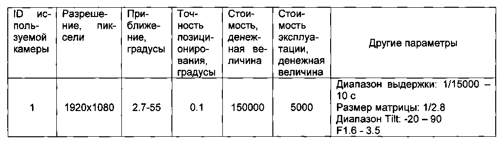
Определены места расстановки вышек, пригодных для установки видеокамер. Ниже дан пример вышеприведенной Таблицы 1, определяющей места расстановки вышек:The locations of towers suitable for the installation of video cameras are determined. The following is an example of Table 1 above, which defines the location of towers:
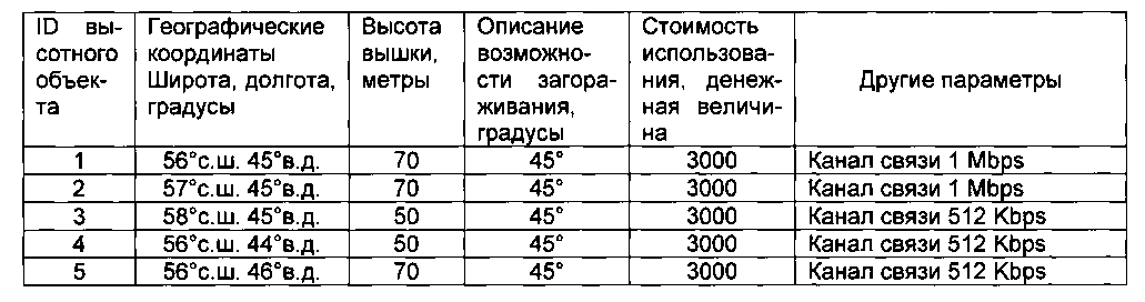
В таком случае, примером кодировки G могут служить следующие строки:In this case, the following lines can serve as an example of the G encoding:
(0,0,0,0,0) - ни на одну вышку не установлено оборудование;(0,0,0,0,0,0) - no equipment was installed on any tower;
(1,1,1,1,1) - на всех вышках установлен один экземпляр оборудования;(1,1,1,1,1,1) - one copy of equipment is installed on all towers;
(1,1,-1,1,1) - на третьей вышке установлено две видеокамеры, так что их зоны загораживания не перекрываются, на остальных вышках установлен один экземпляр оборудования.(1,1, -1,1,1) - two cameras are installed on the third tower, so their obstruction zones do not overlap, on the remaining towers one copy of the equipment is installed.
Кроме того, с каждой позицией строки G ассоциирован набор параметров системы, связанных с соответствующей точкой видеомониторинга. Такой набор может включать следующие параметры:In addition, a set of system parameters associated with the corresponding video monitoring point is associated with each position of line G. Such a set may include the following parameters:
- опорные точки маршрутов осмотра территории (набор значений (Р, Т, Z), где Р и Т - углы азимута и склонения в сферической системе координат с центром в месте расположения камеры, плоскость экватора которой расположена параллельно плоскости геометрического горизонта, а положению нулевого азимута соответствует направление на север, Z - приближение камеры (или связанные величины, такие как фокусное расстояние и углы поля зрения камеры)), тип снимаемого материала (видео, изображения), время съемки одной позиции, параметры съемки (разрешение, параметры фокусировки, выдержки, диафрагмы, скорость съемки (количество кадров в секунду), другие параметры, специфичные для устанавливаемого оборудования, такие как баланс белого, усиление, инфракрасный (IR) фильтр, параметры постобработки изображения и др.), параметры системы компьютерного зрения (пороги на чувствительность, параметры накопления, кластеризации, выделения объектов);- reference points of the routes for exploring the territory (a set of values (P, T, Z), where P and T are the azimuth and declination angles in a spherical coordinate system centered at the location of the camera, the equator plane of which is parallel to the plane of the geometric horizon, and the position of zero azimuth corresponds to the direction to the north, Z - approximation of the camera (or related values, such as the focal length and angles of the camera’s field of view)), the type of material being shot (video, image), the shooting time of one position, shooting parameters (resolution, pairs focusing, shutter speed, aperture, shooting speed (number of frames per second), other parameters specific to the installed equipment, such as white balance, gain, infrared (IR) filter, image post-processing parameters, etc.), computer vision system parameters ( thresholds for sensitivity, parameters of accumulation, clustering, allocation of objects);
- положение видеокамеры на вышке.- the position of the camcorder on the tower.
Показанные на Фиг. 9 операторы ГА генерации начальной популяции, кроссовера и мутации хорошо известны из классической литературы по эволюционно-генетическим алгоритмам (см., например, [3]). При решении рассматриваемых задач хорошо показали себя одноточечные операторы кроссовера и мутации.Shown in FIG. 9 GA operators for generating the initial population, crossover and mutation are well known from the classical literature on evolutionary genetic algorithms (see, for example, [3]). In solving the problems under consideration, the single-point crossover and mutation operators showed themselves well.
При применении кроссовера потомки наследуют не только код генотипа, но и связанные с каждой наследуемой позицией генотипа параметры. При этом, в терминах моделируемой системы такое наследование означает, что каждое из вновь синтезируемых решений наследует часть признаков одного родителя, часть - другого. Другими словами, в решении-потомке конфигурации отдельных точек мониторинга будут взяты из одного родителя, другие - из другого. Если потомок унаследовал "хорошие" части родительских решений, он получает шансы "выжить" в ходе дальнейшей эволюции и "породить" еще более качественные решения. В рассматриваемом предпочтительном алгоритме применяются два вида кроссоверов: одноточечный и равномерный.When using a crossover, the descendants inherit not only the genotype code, but also the parameters associated with each inherited position of the genotype. Moreover, in terms of the simulated system, such inheritance means that each of the newly synthesized solutions inherits some of the characteristics of one parent, and some of the other. In other words, in a descendant solution, the configurations of individual monitoring points will be taken from one parent, others from another. If a descendant inherits the “good” parts of parental decisions, he gets a chance to “survive” in the course of further evolution and to “generate” even better solutions. In the preferred algorithm under consideration, two types of crossovers are used: single-point and uniform.
Мутация подразумевает изменение единичного гена с подбором допустимого набора связанных параметров. В терминах моделируемой системы это означает "сброс" конфигурации одной точки видеомониторинга с последующей попыткой установить на вышку случайный тип оборудования с допустимыми для него режимами эксплуатации.Mutation implies a change in a single gene with the selection of an acceptable set of related parameters. In terms of a simulated system, this means "resetting" the configuration of one video monitoring point with the subsequent attempt to install a random type of equipment on the tower with acceptable operating modes for it.
Оператор оценки реализован в соответствии с методикой, проиллюстрированной со ссылкой на Фиг. 8, и позволяет выбрать критерий из числа определенных методикой оценки либо комбинацию таких критериев.The evaluation operator is implemented in accordance with the methodology illustrated with reference to FIG. 8, and allows you to choose a criterion from among those determined by the assessment methodology or a combination of such criteria.
Оператор генетического взрыва следит за генетическим разнообразием популяции. В случае падения разнообразия ниже заранее заданного порога, данный оператор производит инъекцию нового генетического материала с целью предотвращения преждевременной сходимости алгоритма к локальному оптимуму, далекому от глобального.A genetic explosion operator monitors the genetic diversity of a population. If the variety falls below a predetermined threshold, this operator injects new genetic material in order to prevent premature convergence of the algorithm to a local optimum, far from global.
Отбор представляет собой схему предпочтительного ранжирования с исключением из популяции особей из конца списка предпочтений. При этом популяция делится на группы по количеству используемых видеокамер, из каждой группы удаляются решения, для которых нашлись другие решения, такие что значения критериев для них лучше, но количество используемых камер меньше. Оставшиеся особи упорядочиваются по ухудшению значения критериев. Затем производится отбрасывание по одной особи из хвоста каждой группы до тех пор, пока не будет достигнуто целевое количество особей в популяции.Selection is a preferred ranking scheme with exclusion from the population of individuals from the end of the list of preferences. At the same time, the population is divided into groups according to the number of cameras used, solutions for which other solutions are found are removed from each group, such that the criteria are better for them, but the number of cameras used is less. The remaining individuals are ordered by deterioration of the criteria. Then one individual is dropped from the tail of each group until the target number of individuals in the population is reached.
В качестве условия останова предпочтительно, но не исключительно, используется ограничение по количеству обработанных поколений популяции.As a stopping condition, it is preferable, but not exclusive, to use a limit on the number of processed generations of the population.
Таким образом, генетический алгоритм - это механизм исследования подпространства пространства параметров, связанного с дискретными вариативами.Thus, the genetic algorithm is a mechanism for studying the subspace of the parameter space associated with discrete variations.
С каждой из выбранных схем размещения связан набор оптимальных непрерывных параметров. Оптимизация в подпространстве непрерывных параметров при зафиксированной конфигурации дискретных параметров осуществляется блоком локальной адаптации особей при помощи статистического алгоритма поиска глобального оптимума. Возможные варианты реализации такой оптимизации широко известны в технике (см., например, [10]).A set of optimal continuous parameters is associated with each of the selected layouts. Optimization in the subspace of continuous parameters with a fixed configuration of discrete parameters is carried out by a block of local adaptation of individuals using a statistical algorithm for searching the global optimum. Possible options for implementing such optimization are widely known in the art (see, for example, [10]).
При этом, как было сказано ранее, в качестве критерия используется непосредственно критерий, выбранный в качестве показателя эффективности системы, если он единственный, либо свертка критериев с коэффициентами, характеризующими важность каждого отдельного критерия.Moreover, as was said earlier, the criterion directly uses the criterion, selected as an indicator of the effectiveness of the system, if it is the only one, or a convolution of criteria with coefficients characterizing the importance of each individual criterion.
В процессе локальной адаптации используется одна из двух стратегий применения алгоритма поиска глобального оптимума: глобальная и локальная. Глобальная стратегия подразумевает, что вектор управляемых параметров представляет собой объединение векторов параметров, связанных с каждой позицией перестановки. Таким образом, алгоритм поиска глобального оптимума работает сразу со всеми непрерывными и условно-непрерывными параметрами точек видеонаблюдения в рамках рассматриваемой особи генетического алгоритма. При применении локальной стратегии, в качестве вектора контролируемых параметров используется вектор непрерывных и условно-непрерывных параметров, связанных с одной точкой видеомониторинга. Алгоритм глобального поиска оптимума в этом случае запускается для каждой точки видеомониторинга последовательно и циклически до тех пор, пока "проход" по всем точкам видеомониторинга приводит к улучшению критериев эффективности. Глобальная стратегия обладает существенно большей вычислительной трудоемкостью, но потенциально обеспечивает более высокое качество локальной адаптации.In the process of local adaptation, one of two strategies for applying the global optimum search algorithm is used: global and local. The global strategy implies that the vector of controlled parameters is a union of the parameter vectors associated with each position of the permutation. Thus, the global optimum search algorithm works immediately with all continuous and conditionally continuous parameters of video surveillance points within the framework of the considered individual genetic algorithm. When applying the local strategy, the vector of continuous and conditionally continuous parameters associated with one video monitoring point is used as a vector of controlled parameters. In this case, the global optimum search algorithm is launched for each video monitoring point sequentially and cyclically until the "passage" through all video monitoring points leads to the improvement of performance criteria. The global strategy has significantly greater computational complexity, but potentially provides a higher quality of local adaptation.
Таким образом, после окончания работы блока локальной адаптации, популяция представляет собой набор различных вариантов размещения оборудования на местности, для каждого из которых найден оптимальный набор непрерывных и условно-непрерывных параметров конфигурации системы мониторинга.Thus, after the end of the local adaptation unit, the population is a set of different options for placing equipment on the ground, for each of which an optimal set of continuous and conditionally continuous monitoring system configuration parameters has been found.
Для простоты изложения, но без потери общности, предположим, что набор непрерывных параметров для каждой точки мониторинга состоит из одного параметра - места размещения видеокамеры на вышке А (изменение места размещения приводит к изменению положения слепой зоны, обеспечиваемой загораживанием поля обзора видеокамеры элементами конструкции вышки). Тогда при использовании глобального подхода вектор варьируемых параметров для рассматриваемого примера будет иметь вид (A1, А2, А3, А4, А5), где Ai - размещение камеры на i-той вышке. При использовании локального подхода статистический алгоритм будет поочередно запускаться над одномерными векторами (A1), (А2), (А3), (А4), (А5), (A1), (А2), (А3), (А4), (А5) и т.д. до тех пор, пока происходит улучшение эффективности текущего решения.For simplicity of presentation, but without loss of generality, suppose that the set of continuous parameters for each monitoring point consists of one parameter — the location of the camera on tower A (changing the location leads to a change in the position of the blind zone provided by blocking the field of view of the camera with tower structure elements) . Then, using the global approach, the vector of variable parameters for the considered example will have the form (A 1 , A 2 , A 3 , A 4 , A 5 ), where A i is the camera’s location on the ith tower. When using the local approach, the statistical algorithm will alternately run over the one-dimensional vectors (A 1 ), (A 2 ), (A 3 ), (A 4 ), (A 5 ), (A 1 ), (A 2 ), (A 3 ), (A 4 ), (A 5 ), etc. as long as there is an improvement in the effectiveness of the current solution.
Ниже со ссылкой на Фиг. 10 описывается отвечающий настоящему изобретению способ 1000 определения оптимальной конфигурации системы видеомониторинга леса, пример которой показан на Фиг. 1. Рассматриваемая здесь система видеомониторинга леса может быть планируемой для развертывания.Below with reference to FIG. 10, a
На этапе 1010 собирают множество параметров, относящихся к характеристикам точек видеомониторинга и характеристикам территории размещения точек видеомониторинга. Подробный пример таких параметров самих по себе и путей их получения приведен выше в Таблицах 1-6. Как было сказано ранее, среди указанных параметров имеются параметры, которые являются контролируемыми (или варьируемыми). Примеры контролируемых параметров также даны выше.At 1010, a plurality of parameters are collected relating to the characteristics of the video monitoring points and the characteristics of the location of the video monitoring points. A detailed example of such parameters per se and the ways to obtain them are given above in Tables 1-6. As mentioned earlier, among these parameters there are parameters that are controllable (or variable). Examples of monitored parameters are also given above.
На этапе 1020 задают один или более показателей эффективности системы видеомониторинга леса (т.е. критериев) в соответствии с подходами, раскрытыми выше в разделах 1-4.At 1020, one or more performance indicators of a forest video monitoring system (i.e., criteria) are set in accordance with the approaches disclosed in sections 1-4 above.
На этапе 1030 выполняют перебор вариантов размещения точек видеомониторинга по множеству возможных позиций на территории. Данный перебор отвечает подходу к решению задачи оптимизации, описанному выше. Для этого, итерационным образом выполняется установление конкретного размещения точек видеомониторинга системы на местности и, для установленного размещения точек видеомониторинга, определение такого оптимального набора параметров, который оптимизирует потребный показатель эффективности из показателей эффективности системы видеомониторинга леса, заданных на этапе 1020. При выполнении указанных итераций, потребный показатель эффективности вычисляется с варьированием соответствующих ему контролируемых параметров по итерациям. Как было сказано ранее, потребный показатель эффективности может представлять собой свертку различных показателей эффективности с коэффициентами, характеризующими важность каждого отдельного показателя эффективности.At
Согласно предпочтительному варианту осуществления, перебор вариантов размещения точек видеомониторинга на этапе 1030 прекращается по выполнению заранее заданного условия завершения. Таким условием завершения может быть, например, одно из следующего:According to a preferred embodiment, the enumeration of placement options for the video monitoring points in
- устойчивое отсутствие улучшения потребного показателя эффективности по ходу выполнения итераций перебора;- a steady lack of improvement in the required performance indicator during the execution of iterations of enumeration;
- исчерпание временной квоты, выделенной на выполнение перебора;- exhaustion of the time quota allocated for brute force;
- достижение заранее определенного количества итераций.- achieving a predetermined number of iterations.
Предпочтительно, при выполнении перебора для последующих итераций из рассмотрения исключаются точки видеомониторинга, изменение позиции и/или характеристик которых не оказывает существенного влияния на выполняемую оптимизацию, что позволяет динамически сокращать варианты перебора.Preferably, when performing enumeration for subsequent iterations, video monitoring points are excluded from consideration, changing the position and / or characteristics of which does not significantly affect the optimization being performed, which allows you to dynamically reduce the enumeration options.
На этапе 1040 определяют оптимальную конфигурацию системы видеомониторинга леса. Для этого, полученные размещения точек видеомониторинга, для которых на этапе 1030 определены оптимальные наборы параметров, сравниваются между собой и выбирается тот вариант размещения, которому соответствует наилучшее значение показателя эффективности.At 1040, an optimal configuration of a forest video monitoring system is determined. To do this, the obtained locations of video monitoring points, for which the optimal parameter sets were determined at
Согласно предпочтительному варианту осуществления, на потребный показатель эффективности может быть наложено ограничение или ряд ограничений, пример которых приведен выше в разделе 4. Это делается, в частности, для исключения из сравнения по этапу 1040 тех вариантов размещения точек видеомониторинга, для которых показатель эффективности не удовлетворяет наложенным на него ограничениям.According to a preferred embodiment, a desired performance indicator may be subject to a restriction or a number of restrictions, an example of which is given above in section 4. This is done, in particular, to exclude from the comparison at
Реализация описанного выше способа 1000 может быть осуществлена путем соответственного конфигурирования/программирования компьютера или другой подобной машины. Конфигурирование компьютера для выполнения им функций согласно настоящему изобретению, описанных выше, может быть осуществлено путем инсталляции на него специализированного программного обеспечения, которое при его исполнении предписывает компьютеру выполнять соответствующие функции. Это может быть самостоятельно разработанное программное обеспечение, в том числе с использованием коммерчески и обще доступных сред программирования, библиотек, API и пакетов, заказное программное обеспечение или комбинация вышеперечисленного.The implementation of the
При этом, низкоуровневые аспекты такого компьютера, включая аппаратные средства и базовое программное/программно-аппаратное обеспечение, являются широко известными.At the same time, the low-level aspects of such a computer, including hardware and basic software / firmware, are widely known.
Примером результатов применения предложенных методик оптимизации могут служить графики зависимости обеспечения территории интереса (Фиг. 11) вероятностью обнаружения не ниже заданной (критерий обозначен как "Общее покрытие") и точностью обнаружения не ниже заданной (критерий обозначен как "Территория с большей точностью") от количества устанавливаемых видеокамер (Фиг. 12).An example of the results of applying the proposed optimization techniques can be graphs of the dependence of ensuring the territory of interest (Fig. 11) with a probability of detection not lower than the specified one (criterion is designated as “General coverage”) and detection accuracy not lower than the given one (criterion is designated as “Territory with greater accuracy”) on the number of installed cameras (Fig. 12).
Графики типа "… до оптимизации" представляют значение упомянутых критериев при неоптимальном выборе местоположения точек видеомониторинга (например, на основе визуальной расстановки). Графики типа "… после оптимизации" представляют значения тех же критериев для конфигураций с заданным числом точек видеомониторинга, но выбранных на основе предложенного способа оптимизации. Значения критериев определены для всего диапазона значений количества точек видеомониторинга к установке. Так, например, при неоптимально расставленных 42-ух точках видеомониторинга площадь с вероятностью обнаружения не ниже заданного порога составляет около 27% от общей площади интереса. При оптимальной расстановке тех же 42-ух точек видеомониторинга покрытая площадь составит более 50%. Эти факты проиллюстрированы на Фиг. 13 и Фиг. 14. Иллюстрации позволяют визуально оценить обеспечиваемую разницу в площадях.Charts of the type “... before optimization” represent the value of the mentioned criteria for the non-optimal choice of the location of video monitoring points (for example, based on visual arrangement). Charts of the type “... after optimization” represent the values of the same criteria for configurations with a given number of video monitoring points, but selected based on the proposed optimization method. The values of the criteria are defined for the entire range of values of the number of video monitoring points to be installed. So, for example, with 42 video monitoring points not optimally spaced, the area with a probability of detection not lower than a given threshold is about 27% of the total area of interest. With the optimal placement of the same 42 video monitoring points, the covered area will be more than 50%. These facts are illustrated in FIG. 13 and FIG. 14. Illustrations allow you to visually assess the difference in space provided.
Далее описывается способ оптимальной настройки системы видеомониторинга леса под текущие условия окружающей среды.The following describes how to optimally configure the forest video monitoring system under current environmental conditions.
Как видно из Таблицы 4, конфигурация системы на местности включает два основных блока:As can be seen from Table 4, the configuration of the system on the ground includes two main blocks:
- Блок информации о размещении камер (блок РК): места установки, тип оборудования, направление загораживания конструкции;- Information block about the placement of cameras (RK block): installation location, type of equipment, direction of obstruction of the structure;
- Блок настроек режимов осмотра территории (блок РОТ): используемые маршруты, времена осмотра, настройки системы компьютерного зрения и прочее.- The settings block for the inspection modes of the territory (POT unit): routes used, inspection times, computer vision system settings, etc.
При построении оптимальной конфигурации системы блок оптимизации варьирует параметрами, входящими в оба блока, таким образом одновременно выбирая размещение видеокамер и их будущие режимы работы. При этом, в качестве исходных данных используются архивные данные об изменяющихся условиях на территории (без потери общности, будем говорить об архиве погодных данных). В предположении, что погодные условия на данной территории будут аналогичны архивным, характеристики системы после ее развертывания будут соответствовать таковым, рассчитанным для архивных данных.When constructing the optimal system configuration, the optimization unit varies with the parameters included in both blocks, thus simultaneously choosing the location of the cameras and their future operating modes. At the same time, archival data on changing conditions in the territory are used as initial data (without loss of generality, we will talk about an archive of weather data). Under the assumption that the weather conditions in this territory will be similar to archival, the characteristics of the system after its deployment will correspond to those calculated for archival data.
Очевидно, что погодные условия в процессе эксплуатации системы видеомониторинга леса будут отличаться от средних значений, принятых при проектировании. Как следствие, реальные характеристики системы при этом будут также отличаться от расчетных (т.е. рассчитанных на основе архивных данных), как правило, в худшую сторону. С другой стороны, факт, что система развернута на местности, означает, что зафиксированы значения блока РК Таблицы 4, но данные блока РОТ можно изменять, настраивая режимы работы системы. Общий подход выбора оптимальной конфигурации системы может быть применен для настройки системы в процессе ее эксплуатации (вплоть до настройки в режиме реального времени) с принятием во внимание следующих фактов:It is obvious that the weather conditions during the operation of the forest video monitoring system will differ from the average values adopted during the design. As a result, the actual characteristics of the system will also differ from the calculated ones (i.e., those calculated on the basis of archival data), as a rule, for the worse. On the other hand, the fact that the system is deployed on the ground means that the values of the RK block of Table 4 are fixed, but the data of the POT block can be changed by adjusting the operating modes of the system. The general approach to choosing the optimal system configuration can be applied to configure the system during its operation (up to real-time tuning), taking into account the following facts:
1) пространство варьируемых параметров сокращается до набора, определяемого блоком РОТ Таблицы 4;1) the space of variable parameters is reduced to a set determined by the POT block of Table 4;
2) вместо архивных данных о погоде используются текущие данные о погоде, что можно интерпретировать как использование архивных данных минимальной глубины;2) instead of archived weather data, current weather data are used, which can be interpreted as the use of archived data of minimum depth;
3) нет смысла рассчитывать оценки ущерба, поскольку они имеют смысл "ущерб за определенный период времени", но сама процедура подстройки системы во время эксплуатации подразумевает вычисление моментальных оценок, соответствующих текущим условиям эксплуатации.3) it makes no sense to calculate damage estimates, since they have the meaning of “damage for a certain period of time”, but the procedure for adjusting the system during operation implies the calculation of instantaneous estimates that correspond to current operating conditions.
С учетом вышеперечисленных фактов, процедура оценки показателей эффективности системы по Фиг. 8 в рамках настройки может быть изменена способом, показанным на Фиг. 15.Given the above facts, the procedure for evaluating the performance indicators of the system of FIG. 8 as part of the setting can be changed in the manner shown in FIG. fifteen.
При этом, процедура оптимизации естественным образом модифицируется за счет сокращения набора варьируемых параметров и организации непрерывной подстройки. Фактически, процедура оптимизации представляет собой реализацию блока локальной адаптации эволюционно-генетического алгоритма, описанного выше, работающую при фиксированном размещении точек видеомониторинга системы на местности.At the same time, the optimization procedure is naturally modified by reducing the set of variable parameters and organizing continuous adjustment. In fact, the optimization procedure is an implementation of the local adaptation block of the evolutionary genetic algorithm described above, which works with a fixed placement of the system’s video monitoring points on the ground.
Предполагается, что длительность процесса оптимизации меньше интервала существенного изменения условий окружающей среды. С другой стороны, получить оценку характеристик системы для текущих параметров настройки можно очень быстро. Учитывая, что используемый статистический алгоритм поиска оптимума имеет итерационный характер, от итерации к итерации улучшая имеющееся решение, можно планировать процесс поиска оптимальной конфигурации не по качеству решения, а по времени его поиска, останавливая процесс поиска по достижении заранее заданного лимита времени. Если найденные за отведенное время режимы работы обеспечивают лучшие значения критериев, чем текущие, они немедленно применяются. Такой процесс обеспечивает условно-оптимальную (а при наличии достаточных вычислительных мощностей гарантированную epsilon-оптимальную (см. [2])) настройку системы в зависимости от текущих условий окружающей среды.It is assumed that the duration of the optimization process is less than the interval of a significant change in environmental conditions. On the other hand, an estimate of the system characteristics for the current settings can be obtained very quickly. Considering that the statistical algorithm used to search for the optimum is iterative in nature, improving the existing solution from iteration to iteration, we can plan the search for the optimal configuration not by the quality of the solution, but by the time it was searched, stopping the search process when a predetermined time limit is reached. If the operating modes found within the allotted time provide better criteria than current ones, they are immediately applied. Such a process provides conditionally optimal (and in the presence of sufficient computing power guaranteed epsilon-optimal (see [2])) system configuration depending on current environmental conditions.
Ниже со ссылкой на Фиг. 16 описывается способ 1600 оптимальной настройки системы 100 видеомониторинга леса согласно предпочтительному варианту осуществления настоящего изобретения. По сути, данный способ представляет собой адаптацию вышеописанного способа 1000 к уже развернутой и эксплуатируемой системе видеомониторинга леса.Below with reference to FIG. 16, a
На этапе 1610, аналогично этапу 1010, собирают множество параметров, относящихся к характеристикам точек видеомониторинга и характеристикам территории размещения точек видеомониторинга. Опять же, некоторые из параметров являются контролируемыми;At
На этапе 1620, аналогично этапу 1020, задают показатель эффективности системы видеомониторинга леса.At
На этапе 1630, аналогично этапу 1030, итерационным образом выполняется определение такого оптимального набора параметров, который оптимизирует показатель эффективности, заданный на этапе 1620. При выполнении итераций, показатель эффективности вычисляется с варьированием контролируемых параметров по итерациям. Как было сказано выше, определение оптимального набора параметров может завершаться по истечении заранее заданного времени.At
Наконец, на этапе 1640, выполняют корректировку контролируемых параметров системы видеомониторинга леса до оптимального набора параметров. Корректировка может выполняться фактически непрерывным образом, а может выполняться только при условии того, что полученный оптимальный набор параметров обеспечивает значительное улучшение работы системы видеомониторинга леса в плане рассматриваемого показателя эффективности, например, на величину, не меньшую заранее заданного порога.Finally, at
Описанный способ 1600 может быть реализован компьютерным образом, по сути, аналогично тому, что указано выше в отношении способа 1000, специализированным модулем настройки в составе системы 100 видеомониторинга леса. Согласно предпочтительному варианту осуществления, модуль настройки может быть реализован в виде программного обеспечения, исполняющегося на сервере 140 или на одном или более из терминальных компьютеров 120 рабочих мест операторов. В то же время, модуль настройки может быть реализован и как отдельный компьютерный аппаратный компонент системы 100, подключенный к сети 130 для взаимодействия с другими ее компонентами и сконфигурированный известным образом для выполнения соответствующих этапов способа 1600. При этом, непосредственная реализация оптимальной подстройки системы согласно настоящему изобретению путем соответственного удаленного изменения параметров оборудования относится к широко известным аспектам эксплуатации такого рода систем видеонаблюдения, вкратце отмеченным выше.The described
Параметры, приведенные в Таблицах 1-6, могут храниться в отдельном или распределенном сетевом хранилище данных, и в составе системы 100, и внешним по отношению к ней образом, и в виде комбинации этих двух вариантов. В случае реализации модуля настройки на сервере 140, указанные параметры могут храниться, по меньшей мере частично, на запоминающем устройстве из состава сервера 140. В случае же реализации модуля настройки на операторском терминале 120, параметры могут храниться, по меньшей мере частично, на запоминающем устройстве из состава терминала 120. В случае реализации модуля настройки в виде обособленного компьютерного устройства в системе 100, указанные параметры могут храниться, по меньшей мере частично, на запоминающем устройстве из состава этого компьютерного устройства. Помимо этого, некоторые из параметров могут извлекаться из внешних источников данных в режиме онлайн. Рассматриваемый в данном абзаце аспект должен быть очевидным для специалиста и поэтому дополнительно не обсуждается.The parameters shown in Tables 1-6 can be stored in a separate or distributed network storage, and as part of the system 100, and external to it, and as a combination of these two options. In the case of the implementation of the settings module on the server 140, these parameters can be stored at least partially on the storage device from the server 140. In the case of the implementation of the settings module on the operator terminal 120, the parameters can be stored at least partially on the storage device from the composition of the terminal 120. In the case of the implementation of the configuration module in the form of a separate computer device in the system 100, these parameters can be stored, at least partially, on a storage device from this computer device. In addition, some of the parameters can be retrieved from external data sources online. The aspect considered in this paragraph should be obvious to a person skilled in the art and therefore is not further discussed.
Изобретение было раскрыто выше со ссылкой на конкретные варианты его осуществления. В рамках существа вышеприведенного раскрытия, для специалистов могут быть очевидны и иные варианты осуществления изобретения, отличающиеся от тех, что изложены в настоящем описании. Соответственно, изобретение следует считать ограниченным по объему только нижеследующей формулой изобретения и ее эквивалентами.The invention has been disclosed above with reference to specific options for its implementation. Within the spirit of the foregoing disclosure, other embodiments of the invention that are different from those set forth herein may be apparent to those skilled in the art. Accordingly, the invention should be considered limited in scope only by the following claims and their equivalents.
Список процитированных источниковList of cited sources
[1] Черняк B.C. "Многопозиционная радиолокация", М.: Радио и связь, 1993 г.[1] Chernyak B.C. "Multipositional Radar", M .: Radio and communications, 1993
[2] Гэри М., Джонсон Д. "Вычислительные машины и труднорешаемые задачи", М.: Мир, 1982 г.[2] Gary M., Johnson D. "Computing machines and hard problems", M .: Mir, 1982
[3] Батищев Д.И. "Генетические алгоритмы решения экстремальных задач", Учебное пособие, под ред. Львовича Я.Е., Воронеж, 1995 г., 64 с.[3] Batishchev D.I. "Genetic Algorithms for Solving Extreme Problems", Textbook, ed. Lvovich Ya.E., Voronezh, 1995, 64 p.
[4] Пападимитриу X., Стайглиц К. "Комбинаторная оптимизация: Алгоритмы и сложность", М.: Мир, 1985 г.[4] Papadimitriou X., Steiglitz K. "Combinatorial optimization: Algorithms and complexity", M .: Mir, 1985
[5] Kate Gregory, Ade Miller "Accelerated Massive Parallelism with Microsoft® Visual С++", Microsoft Press, 2012[5] Kate Gregory, Ade Miller "Accelerated Massive Parallelism with Microsoft® Visual C ++", Microsoft Press, 2012
[6] Постановление Правительства РФ №838 от 29 декабря 2006 г. "Об утверждении методики распределения между субъектами Российской Федерации субвенций из федерального фонда компенсаций для осуществления отдельных полномочий Российской Федерации в области лесных отношений, реализация которых передана органам государственной власти субъектов Российской Федерации"[6] Decree of the Government of the Russian Federation No. 838 of December 29, 2006 "On the Approval of the Methodology for Distributing Subventions between the Subjects of the Russian Federation from the Federal Compensation Fund for the Exercise of Separate Powers of the Russian Federation in the Field of Forest Relations, the Implementation of which has been Transferred to the Government of the Subjects of the Russian Federation"
[7] Методические рекомендации министерства природных ресурсов РФ, Справочник по тушению природных пожаров, проект ПРООН/МКИ "Расширение сети ООПТ для сохранения Алтая-Саянского экорегиона", Красноярск, 2011 г.[7] Methodological recommendations of the Ministry of Natural Resources of the Russian Federation, Handbook on extinguishing natural fires, UNDP / ICE project "Expanding the network of protected areas to preserve the Altai-Sayan Ecoregion", Krasnoyarsk, 2011
[8] Приказ №287 Рослесхоза от 5 июля 2011 г. "Об утверждении классификации природной пожарной опасности лесов и классификации пожарной опасности в лесах в зависимости от условий погоды"[8] Order No. 287 of the Federal Forestry Agency dated July 5, 2011 "On approval of the classification of the natural fire hazard of forests and the classification of fire hazard in forests, depending on weather conditions"
[9] Приказ №53 Рослесхоза от 3 апреля 1998 г.[9] Order No. 53 of the Federal Forestry Agency of April 3, 1998
[10] Стронгин Р.Г. "Численные методы в многоэкстремальных задачах. Оптимизация и исследование операций", Главная редакция физико-математической литературы издательства "Наука", Москва, 1978, 240 с.[10] Strongin R.G. "Numerical methods in multi-extremal problems. Optimization and investigation of operations," Main editors of the physical and mathematical literature of the Nauka publishing house, Moscow, 1978, 240 pp.
Claims (28)
собирают множество параметров, относящихся к характеристикам точек видеомониторинга и характеристикам территории размещения точек видеомониторинга, причем характеристики территории включают в себя ландшафтные характеристики, погодные данные и данные о лесных пожарах, при этом по меньшей мере некоторые из параметров, относящихся к характеристикам точек видеомониторинга, являются контролируемыми;
задают один или более показателей эффективности системы видеомониторинга леса, причем каждый из этих показателей эффективности является интегральной величиной, описываемой вероятностной моделью, обобщающей, по меньшей мере, часть упомянутого множества параметров;
выполняют перебор вариантов размещения точек видеомониторинга по множеству возможных позиций на территории посредством того, что:
устанавливают размещение точек видеомониторинга и
для установленного размещения точек видеомониторинга определяют оптимальный набор параметров, оптимизирующий по меньшей мере один показатель эффективности из упомянутых одного или более показателей эффективности системы видеомониторинга леса, при этом данный показатель эффективности вычисляют с варьированием соответствующих ему контролируемых параметров; и
определяют оптимальную конфигурацию системы видеомониторинга леса посредством того, что:
сравнивают полученные варианты размещения точек видеомониторинга, для которых определены оптимальные наборы параметров, и
выбирают вариант размещения с наилучшим значением упомянутого показателя эффективности.1. A method for determining the optimal configuration of a forest video monitoring system containing a plurality of video monitoring points, each of which contains a video camera on a high-rise structure, the method comprising the steps of:
they collect many parameters related to the characteristics of video monitoring points and the characteristics of the territory where the video monitoring points are located, and the characteristics of the territory include landscape characteristics, weather data and data on forest fires, while at least some of the parameters related to the characteristics of video monitoring points are controlled ;
setting one or more performance indicators of the forest video monitoring system, each of these performance indicators being an integral quantity described by a probabilistic model summarizing at least a portion of said plurality of parameters;
sorting out the options for placing video monitoring points for the set of possible positions in the territory by means of:
establish the placement of video monitoring points and
for the established placement of video monitoring points, an optimal set of parameters is determined that optimizes at least one performance indicator from the one or more forest video monitoring system performance indicators, while this performance indicator is calculated by varying the corresponding monitoring parameters; and
determine the optimal configuration of the forest video monitoring system by the fact that:
comparing the obtained placement options for video monitoring points for which optimal sets of parameters are determined, and
choose the placement option with the best value of said performance indicator.
собирают множество параметров, относящихся к характеристикам точек видеомониторинга и характеристикам территории размещения точек видеомониторинга, причем характеристики территории включают в себя ландшафтные характеристики, погодные данные и данные о лесных пожарах, при этом по меньшей мере некоторые из параметров, относящихся к характеристикам точек видеомониторинга, являются контролируемыми;
задают по меньшей мере один показатель эффективности системы видеомониторинга леса, причем этот показатель эффективности является интегральной величиной, описываемой вероятностной моделью, обобщающей упомянутое множество параметров;
определяют оптимальный набор параметров, который оптимизирует упомянутый по меньшей мере один показатель эффективности системы видеомониторинга леса, при этом данный показатель эффективности вычисляют с варьированием контролируемых параметров;
выполняют корректировку контролируемых параметров системы видеомониторинга леса до оптимального набора параметров.17. A method for optimally configuring a forest video monitoring system comprising a plurality of distributed video monitoring points, each of which contains a video camera on a high-rise structure, the method comprising the steps of:
they collect a lot of parameters related to the characteristics of video monitoring points and the characteristics of the territory where the video monitoring points are located, and the characteristics of the territory include landscape characteristics, weather data and data on forest fires, while at least some of the parameters related to the characteristics of video monitoring points are controlled ;
at least one indicator of the effectiveness of the forest video monitoring system is set, and this indicator of effectiveness is an integral quantity described by a probabilistic model generalizing the aforementioned set of parameters;
determine the optimal set of parameters, which optimizes the aforementioned at least one indicator of the effectiveness of the forest video monitoring system, while this indicator of efficiency is calculated with variation of the controlled parameters;
carry out the adjustment of the monitored parameters of the forest video monitoring system to the optimal set of parameters.
множество дистанционно управляемых точек видеомониторинга, каждая из которых содержит видеокамеру на высотном сооружении;
один или более операторских компьютерных терминалов и
компьютерно-реализованный модуль настройки,
при этом модуль настройки выполнен с возможностью рассчитывать по меньшей мере один показатель эффективности системы видеомониторинга леса, причем этот показатель эффективности является интегральной величиной, описываемой вероятностной моделью, обобщающей собранное множество параметров, относящихся к характеристикам точек видеомониторинга и характеристикам территории размещения точек видеомониторинга, причем характеристики территории включают в себя ландшафтные характеристики, погодные данные и данные о лесных пожарах, при этом по меньшей мере некоторые из параметров, относящихся к характеристикам точек видеомониторинга, являются контролируемыми;
при этом модуль настройки сконфигурирован:
определять оптимальный набор параметров, который оптимизирует упомянутый по меньшей мере один показатель эффективности системы видеомониторинга леса, при этом данный показатель эффективности итерационно вычисляется с варьированием контролируемых параметров, и
выполнять корректировку контролируемых параметров системы видеомониторинга леса до оптимального набора параметров.22. A forest video monitoring system, comprising:
many remotely controlled video monitoring points, each of which contains a video camera on a high-rise structure;
one or more operator computer terminals and
computer-implemented configuration module,
wherein the tuning module is configured to calculate at least one indicator of the effectiveness of the forest video monitoring system, and this efficiency indicator is an integral quantity described by a probabilistic model, generalizing the collected set of parameters related to the characteristics of the video monitoring points and the characteristics of the location of the video monitoring points, and the characteristics of the territory include landscape features, weather data, and forest fire data, while at least some of the parameters relating to the characteristics of the video monitoring points are controlled;
wherein the configuration module is configured:
determine the optimal set of parameters that optimizes the mentioned at least one indicator of the effectiveness of the forest video monitoring system, while this indicator of efficiency is iteratively calculated with variation of the controlled parameters, and
adjust the monitored parameters of the forest video monitoring system to the optimal set of parameters.
Priority Applications (4)
| Application Number | Priority Date | Filing Date | Title |
|---|---|---|---|
| RU2013156177/13A RU2561925C2 (en) | 2013-12-16 | 2013-12-16 | Method of determining optimum configuration of forest video monitoring system |
| PCT/RU2014/000829 WO2015094014A2 (en) | 2013-12-16 | 2014-10-31 | Process for determining the optimum configuration of a forest video monitoring system |
| EA201600379A EA031704B1 (en) | 2013-12-16 | 2014-10-31 | Method for determination of optimal forest video monitoring system configuration |
| US14/895,215 US20160313120A1 (en) | 2013-12-16 | 2014-10-31 | Method for determination of optimal forest video monitoring system configuration |
Applications Claiming Priority (1)
| Application Number | Priority Date | Filing Date | Title |
|---|---|---|---|
| RU2013156177/13A RU2561925C2 (en) | 2013-12-16 | 2013-12-16 | Method of determining optimum configuration of forest video monitoring system |
Publications (2)
| Publication Number | Publication Date |
|---|---|
| RU2013156177A RU2013156177A (en) | 2015-07-27 |
| RU2561925C2 true RU2561925C2 (en) | 2015-09-10 |
Family
ID=53403851
Family Applications (1)
| Application Number | Title | Priority Date | Filing Date |
|---|---|---|---|
| RU2013156177/13A RU2561925C2 (en) | 2013-12-16 | 2013-12-16 | Method of determining optimum configuration of forest video monitoring system |
Country Status (4)
| Country | Link |
|---|---|
| US (1) | US20160313120A1 (en) |
| EA (1) | EA031704B1 (en) |
| RU (1) | RU2561925C2 (en) |
| WO (1) | WO2015094014A2 (en) |
Cited By (1)
| Publication number | Priority date | Publication date | Assignee | Title |
|---|---|---|---|---|
| RU2695406C1 (en) * | 2018-06-21 | 2019-07-23 | Петр Ксенофонтович Васильев | Method of forest fire extinguishing in initial stage with application of hardware and software complex of automatic fire extinguishing |
Families Citing this family (36)
| Publication number | Priority date | Publication date | Assignee | Title |
|---|---|---|---|---|
| US10382662B1 (en) * | 2017-09-06 | 2019-08-13 | The United States Of America, As Represented By The Secretary Of The Navy | Apparatus and method for locating camera towers and scheduling surveillance |
| US10814150B2 (en) | 2017-12-02 | 2020-10-27 | M-Fire Holdings Llc | Methods of and system networks for wireless management of GPS-tracked spraying systems deployed to spray property and ground surfaces with environmentally-clean wildfire inhibitor to protect and defend against wildfires |
| US11395931B2 (en) | 2017-12-02 | 2022-07-26 | Mighty Fire Breaker Llc | Method of and system network for managing the application of fire and smoke inhibiting compositions on ground surfaces before the incidence of wild-fires, and also thereafter, upon smoldering ambers and ashes to reduce smoke and suppress fire re-ignition |
| US11865394B2 (en) | 2017-12-03 | 2024-01-09 | Mighty Fire Breaker Llc | Environmentally-clean biodegradable water-based concentrates for producing fire inhibiting and fire extinguishing liquids for fighting class A and class B fires |
| US20240157180A1 (en) | 2021-02-04 | 2024-05-16 | Mighty Fire Breaker Llc | Method of and kit for installing and operating a wildfire defense spraying system on a property parcel for proactively spraying environmentally-clean liquid fire inhibitor thereover to inhibit fire ignition and flame spread caused by wind-driven wildfire embers |
| US12594448B2 (en) | 2019-06-22 | 2026-04-07 | Mighty Fire Breaker Llc | Environmentally-clean aqueous-based fire extinguishing biochemical liquid concentrates for mixing with proportioned quantities of water to produce fire extinguishing water streams |
| US11865390B2 (en) | 2017-12-03 | 2024-01-09 | Mighty Fire Breaker Llc | Environmentally-clean water-based fire inhibiting biochemical compositions, and methods of and apparatus for applying the same to protect property against wildfire |
| US10695597B2 (en) | 2017-12-02 | 2020-06-30 | M-Fire Holdings Llc | Method of and apparatus for applying fire and smoke inhibiting compositions on ground surfaces before the incidence of wild-fires, and also thereafter, upon smoldering ambers and ashes to reduce smoke and suppress fire re-ignition |
| US10653904B2 (en) | 2017-12-02 | 2020-05-19 | M-Fire Holdings, Llc | Methods of suppressing wild fires raging across regions of land in the direction of prevailing winds by forming anti-fire (AF) chemical fire-breaking systems using environmentally clean anti-fire (AF) liquid spray applied using GPS-tracking techniques |
| US11826592B2 (en) | 2018-01-09 | 2023-11-28 | Mighty Fire Breaker Llc | Process of forming strategic chemical-type wildfire breaks on ground surfaces to proactively prevent fire ignition and flame spread, and reduce the production of smoke in the presence of a wild fire |
| US20190266282A1 (en) * | 2018-02-28 | 2019-08-29 | Ent. Services Development Corporation Lp | Systems and methods for constrained directed media searches |
| CN111385466B (en) * | 2018-12-30 | 2021-08-24 | 浙江宇视科技有限公司 | Autofocus method, device, device and storage medium |
| US20200338375A1 (en) * | 2019-04-25 | 2020-10-29 | Staigh Creagan, Inc. | Fire suppression system |
| US11620891B2 (en) * | 2019-10-10 | 2023-04-04 | Ai4 International Oy | Method and system for determining area of fire and estimating progression of fire |
| CN110706447B (en) * | 2019-10-14 | 2022-05-03 | 浙江大华技术股份有限公司 | Disaster location determination method, device, storage medium and electronic device |
| CN111062950A (en) * | 2019-11-29 | 2020-04-24 | 南京恩博科技有限公司 | Method, storage medium and equipment for multi-class forest scene image segmentation |
| US12599797B2 (en) | 2020-03-01 | 2026-04-14 | Mighty Fire Breaker Llc | Environmentally-clean fire inhibiting and extinguishing compositions and products for sorbing flammable liquids while inhibiting ignition and extinguishing fire |
| US11911643B2 (en) | 2021-02-04 | 2024-02-27 | Mighty Fire Breaker Llc | Environmentally-clean fire inhibiting and extinguishing compositions and products for sorbing flammable liquids while inhibiting ignition and extinguishing fire |
| CN111667656A (en) * | 2020-06-05 | 2020-09-15 | 国网电力科学研究院有限公司 | Screening system and method for fire point of mountain fire in transmission line |
| CN113807624B (en) * | 2020-06-15 | 2025-05-27 | 青岛奥利普奇智智能工业技术有限公司 | Customized configuration method and system based on graphical material and element balance |
| US12616859B2 (en) | 2021-02-04 | 2026-05-05 | Mighty Fire Breaker Llc | Method of and system for defending home building projects from wildfire during and after construction on property located within a wildfire urban interface (WUI) region |
| CN113489952B (en) * | 2021-06-30 | 2022-03-22 | 电子科技大学 | Video monitoring facility layout method oriented to indoor three-dimensional scene |
| CN113793021B (en) * | 2021-09-10 | 2024-05-14 | 广东电网有限责任公司 | Three-dimensional power transmission corridor mountain fire monitoring device and method |
| CN114067455B (en) * | 2021-11-15 | 2023-08-29 | 李政力 | Intelligent pipe inspection method for urban landscaping |
| CN114821289B (en) * | 2022-01-17 | 2023-10-17 | 电子科技大学 | A real-time segmentation and fire edge point monitoring algorithm for forest fire pictures |
| CN114842380B (en) * | 2022-04-27 | 2024-05-14 | 安徽工业大学科技园有限公司 | Fire monitoring method, device, system, memory and processor |
| CN114724323B (en) * | 2022-06-09 | 2022-09-02 | 北京科技大学 | A method of deploying a portable fire site protection smart electronic fence |
| US20240119736A1 (en) * | 2022-07-15 | 2024-04-11 | Jack Wade | System and Method to Facilitate Monitoring Remote Sites using Bandwidth Optimized Intelligent Video Streams with Enhanced Selectivity |
| CN115412704B (en) * | 2022-07-15 | 2024-09-24 | 浙江大华技术股份有限公司 | Control method of video monitoring system, video monitoring system and storage medium |
| CN116155747B (en) * | 2023-02-06 | 2024-10-01 | 广州广哈通信股份有限公司 | Network monitoring node deployment method and device |
| CN116402807A (en) * | 2023-05-11 | 2023-07-07 | 云南电投绿能科技有限公司 | Slope crack state prediction method, device, equipment and storage medium |
| GB2634289A (en) * | 2023-10-05 | 2025-04-09 | Milestone Systems As | Method for improving a configuration of a camera system |
| CN117710173A (en) * | 2023-12-26 | 2024-03-15 | 暗物质(北京)智能科技有限公司 | Forest fire risk assessment method and device, electronic equipment and readable storage medium |
| CN118097922B (en) * | 2024-04-26 | 2024-07-26 | 浙江省森林资源监测中心(浙江省林业调查规划设计院) | Intelligent early warning system for fire disaster in agriculture and forestry area based on data acquisition and analysis |
| CN118569891B (en) * | 2024-07-30 | 2024-09-24 | 广东省林业科学研究院 | Edible forest product traceability management platform based on big data analysis |
| CN119399659B (en) * | 2024-12-31 | 2025-04-29 | 吉林省建研科技有限责任公司 | A fire point monitoring method and system based on optical signals |
Citations (4)
| Publication number | Priority date | Publication date | Assignee | Title |
|---|---|---|---|---|
| US5734335A (en) * | 1989-12-20 | 1998-03-31 | Finmeccanica S.P.A. | Forest surveillance and monitoring system for the early detection and reporting of forest fires |
| RU2293998C2 (en) * | 2001-05-30 | 2007-02-20 | Институто Супериор Текнико | Lidar-based system provided with computer control for smoke identification, particularly, for revealing forest fire at early stage |
| RU113046U1 (en) * | 2011-08-29 | 2012-01-27 | Закрытое акционерное общество "Видеофон МВ" | COMPREHENSIVE SYSTEM FOR EARLY DETECTION OF FOREST FIRES, BUILT ON THE PRINCIPLE OF A VARIETY SENSOR PANORAMIC SURVEY OF THE AREA WITH THE FUNCTION OF HIGH-PRECISION DETERMINATION OF THE FIRE OF THE FIRE |
| RU2458407C1 (en) * | 2011-03-02 | 2012-08-10 | Общество с ограниченной ответственностью "ДиСиКон" (ООО "ДСК") | Forest video monitoring system and method |
-
2013
- 2013-12-16 RU RU2013156177/13A patent/RU2561925C2/en not_active IP Right Cessation
-
2014
- 2014-10-31 WO PCT/RU2014/000829 patent/WO2015094014A2/en not_active Ceased
- 2014-10-31 US US14/895,215 patent/US20160313120A1/en not_active Abandoned
- 2014-10-31 EA EA201600379A patent/EA031704B1/en not_active IP Right Cessation
Patent Citations (4)
| Publication number | Priority date | Publication date | Assignee | Title |
|---|---|---|---|---|
| US5734335A (en) * | 1989-12-20 | 1998-03-31 | Finmeccanica S.P.A. | Forest surveillance and monitoring system for the early detection and reporting of forest fires |
| RU2293998C2 (en) * | 2001-05-30 | 2007-02-20 | Институто Супериор Текнико | Lidar-based system provided with computer control for smoke identification, particularly, for revealing forest fire at early stage |
| RU2458407C1 (en) * | 2011-03-02 | 2012-08-10 | Общество с ограниченной ответственностью "ДиСиКон" (ООО "ДСК") | Forest video monitoring system and method |
| RU113046U1 (en) * | 2011-08-29 | 2012-01-27 | Закрытое акционерное общество "Видеофон МВ" | COMPREHENSIVE SYSTEM FOR EARLY DETECTION OF FOREST FIRES, BUILT ON THE PRINCIPLE OF A VARIETY SENSOR PANORAMIC SURVEY OF THE AREA WITH THE FUNCTION OF HIGH-PRECISION DETERMINATION OF THE FIRE OF THE FIRE |
Non-Patent Citations (1)
| Title |
|---|
| Cтатья "Лесной дозор", http://www.lesdozor.ru/ru/problemy-obnaruzheniya-lesnyh-pozharov/analitika/qlesnoj-dozorq-effektivnaya-sistema-rannego-obnaruzheniya-lesnykh-pozharov, размещенная на сайте 26.03.2013; . * |
Cited By (1)
| Publication number | Priority date | Publication date | Assignee | Title |
|---|---|---|---|---|
| RU2695406C1 (en) * | 2018-06-21 | 2019-07-23 | Петр Ксенофонтович Васильев | Method of forest fire extinguishing in initial stage with application of hardware and software complex of automatic fire extinguishing |
Also Published As
| Publication number | Publication date |
|---|---|
| WO2015094014A2 (en) | 2015-06-25 |
| EA031704B1 (en) | 2019-02-28 |
| RU2013156177A (en) | 2015-07-27 |
| EA201600379A1 (en) | 2016-11-30 |
| WO2015094014A3 (en) | 2015-09-11 |
| US20160313120A1 (en) | 2016-10-27 |
Similar Documents
| Publication | Publication Date | Title |
|---|---|---|
| WO2015094014A2 (en) | Process for determining the optimum configuration of a forest video monitoring system | |
| US20240428516A1 (en) | Systems and methods for controlling a fleet of drones for data collection | |
| US10354386B1 (en) | Remote sensing of structure damage | |
| US8972306B2 (en) | System and method for sensor tasking | |
| US8731241B2 (en) | Activity mapping system | |
| CN114202783A (en) | Target Tracking Method Based on Millimeter Wave Radar | |
| JP2010147560A (en) | Target tracker | |
| AU2017399711A1 (en) | Short term cloud forecast, improved cloud recognition and prediction and uncertainty index estimation | |
| RU2504014C1 (en) | Method of controlling monitoring system and system for realising said method | |
| CN116910491A (en) | Lightning monitoring and early warning system and method, electronic equipment and storage medium | |
| US20240053287A1 (en) | Probability of detection of lifecycle phases of corrosion under insulation using artificial intelligence and temporal thermography | |
| WO2024035640A2 (en) | Probability of detection of lifecycle phases of corrosion under insulation using artificial intelligence and temporal thermography | |
| JP6190862B2 (en) | Monitoring system and monitoring control device thereof | |
| US12598272B2 (en) | PT/PT-Z camera command, control and visualization system and method utilizing artificial intelligence | |
| US20220005331A1 (en) | Monitoring system, monitoring apparatus, monitoring method, and computer readable medium | |
| Fan et al. | Enhancing situational awareness with adaptive firefighting drones: leveraging diverse media types and classifiers | |
| Shostko et al. | Information-measuring system of polygon based on wireless sensor infocommunication network | |
| Wei et al. | Enhancing the binary classification of wildfire smoke through vision-language models | |
| CN109640057A (en) | A kind of transmission line of electricity video monitoring method and relevant apparatus | |
| US20250172689A1 (en) | Radar layout method applied to bird invasion detection | |
| CN116386243B (en) | A linkage method, device and electronic equipment | |
| JPWO2019003400A1 (en) | Coefficient calculation device, coefficient calculation method, and coefficient calculation program | |
| CN114359374A (en) | Method and device for automatically matching camera position, computer equipment and storage medium | |
| CN119070877A (en) | A ground system for interacting with satellites | |
| Baylog et al. | Multiple pass collaborative search in the presence of false alarms |
Legal Events
| Date | Code | Title | Description |
|---|---|---|---|
| HE9A | Changing address for correspondence with an applicant | ||
| MM4A | The patent is invalid due to non-payment of fees |
Effective date: 20201217 |