US10074266B2 - Method for managing a system of geographical information adapted for use with at least one pointing device, with creation of associations between digital objects - Google Patents
Method for managing a system of geographical information adapted for use with at least one pointing device, with creation of associations between digital objects Download PDFInfo
- Publication number
- US10074266B2 US10074266B2 US14/137,205 US201314137205A US10074266B2 US 10074266 B2 US10074266 B2 US 10074266B2 US 201314137205 A US201314137205 A US 201314137205A US 10074266 B2 US10074266 B2 US 10074266B2
- Authority
- US
- United States
- Prior art keywords
- pointing device
- digital
- central unit
- data base
- digital objects
- Prior art date
- Legal status (The legal status is an assumption and is not a legal conclusion. Google has not performed a legal analysis and makes no representation as to the accuracy of the status listed.)
- Active, expires
Links
Images




Classifications
-
- G—PHYSICS
- G08—SIGNALLING
- G08C—TRANSMISSION SYSTEMS FOR MEASURED VALUES, CONTROL OR SIMILAR SIGNALS
- G08C17/00—Arrangements for transmitting signals characterised by the use of a wireless electrical link
- G08C17/02—Arrangements for transmitting signals characterised by the use of a wireless electrical link using a radio link
-
- G—PHYSICS
- G06—COMPUTING OR CALCULATING; COUNTING
- G06F—ELECTRIC DIGITAL DATA PROCESSING
- G06F16/00—Information retrieval; Database structures therefor; File system structures therefor
- G06F16/20—Information retrieval; Database structures therefor; File system structures therefor of structured data, e.g. relational data
- G06F16/29—Geographical information databases
-
- G06F17/30241—
-
- G—PHYSICS
- G06—COMPUTING OR CALCULATING; COUNTING
- G06F—ELECTRIC DIGITAL DATA PROCESSING
- G06F3/00—Input arrangements for transferring data to be processed into a form capable of being handled by the computer; Output arrangements for transferring data from processing unit to output unit, e.g. interface arrangements
- G06F3/01—Input arrangements or combined input and output arrangements for interaction between user and computer
- G06F3/03—Arrangements for converting the position or the displacement of a member into a coded form
- G06F3/033—Pointing devices displaced or positioned by the user, e.g. mice, trackballs, pens or joysticks; Accessories therefor
- G06F3/0346—Pointing devices displaced or positioned by the user, e.g. mice, trackballs, pens or joysticks; Accessories therefor with detection of the device orientation or free movement in a three-dimensional [3D] space, e.g. 3D mice, 6-DOF [six degrees of freedom] pointers using gyroscopes, accelerometers or tilt-sensors
-
- G—PHYSICS
- G06—COMPUTING OR CALCULATING; COUNTING
- G06F—ELECTRIC DIGITAL DATA PROCESSING
- G06F3/00—Input arrangements for transferring data to be processed into a form capable of being handled by the computer; Output arrangements for transferring data from processing unit to output unit, e.g. interface arrangements
- G06F3/01—Input arrangements or combined input and output arrangements for interaction between user and computer
- G06F3/048—Interaction techniques based on graphical user interfaces [GUI]
- G06F3/0481—Interaction techniques based on graphical user interfaces [GUI] based on specific properties of the displayed interaction object or a metaphor-based environment, e.g. interaction with desktop elements like windows or icons, or assisted by a cursor's changing behaviour or appearance
- G06F3/04815—Interaction with a metaphor-based environment or interaction object displayed as three-dimensional [3D], e.g. changing the user viewpoint with respect to the environment or object
-
- G—PHYSICS
- G08—SIGNALLING
- G08C—TRANSMISSION SYSTEMS FOR MEASURED VALUES, CONTROL OR SIMILAR SIGNALS
- G08C21/00—Systems for transmitting the position of an object with respect to a predetermined reference system, e.g. tele-autographic system
Definitions
- the field of the invention is that of geographical information systems (GIS) comprising a central unit accessing a data base containing a plurality of digital objects. It is assumed that each digital object has an identifier and is defined in the data base by a geometrical component defining a geographical position and by a descriptive component describing at least one descriptive attribute.
- GIS geographical information systems
- the invention pertains to a technique for managing a geographical information system of this kind when this system is adapted for use with at least one pointing device.
- the central unit is adapted to determining whether the position of one of the digital objects of the data base is being pointed at by the given pointing device. It determines this fact from the geographical components of the digital objects and from information on the position and orientation of a given pointing device.
- a pointing device is pointing at (i.e. is directed towards) a target device (the device that is being pointed at)
- the pointing device and the device pointed at must be designed to work together (one has a sender and the other a receiver capable of detecting a signal sent by the sender).
- a television set typically comprises an infrared receiver capable of receiving infrared signals sent by a remote control unit supplied with this television set.
- the technique proposed in the application FR1252873 (the operation of which is described in detail further below with reference to FIGS. 1 and 2 ) consists of the use of a central unit to determine which device or devices are pointed at by the pointing device.
- This technique thus provides several advantages as compared with the above-mentioned prior-art techniques. Indeed, it is the central unit that obtains a piece of 3D pointing information, i.e. a piece of information indicating those devices, pointed at, towards which the pointing device is physically oriented, in a 3D space. It is therefore not necessary for the pointing device and the device or devices pointed at to be designed to work together (there is no need for one device to have a sender and the other to have a receiver matching the sender).
- knowledge of the 3D pointing information makes it possible to create an association between the pointing device and the device or devices pointed at. It is possible to create applications resulting from this association (especially but not exclusively to control the device pointed at by the pointing device).
- One particular embodiment of the invention proposes a method for managing a geographical information system adapted for use with at least one pointing device, the geographical information system comprising a central unit accessing a data base containing a plurality of digital objects, each digital object possessing an identifier and being defined in the data base by a geometrical component defining a geographical position and by a descriptive component defining at least one descriptive attribute, the central unit being adapted to determining, as a function of the geometrical components of the digital objects and information on the position and orientation of a given pointing device, whether the position of one of the digital objects is pointed at by the given pointing device.
- the central unit performs a step for creating an association between at least two digital objects contained in said data base, in order to form a group of associated digital objects.
- the general principle of the invention consists therefore in creating associations between (two or more) digital objects contained in the data base of the geographical information system.
- the creation of an association (and therefore of a group of associated digital objects) enables the storage and retrieval of information (on digital objects contained in the data base) by a very simple mnemotechnic method. Indeed, by pointing towards a first digital object belonging to a group of associated digital objects (or more specifically towards the position of this first digital object, as defined in its geometrical component), the user can access all the digital objects of this group (and therefore the descriptive attributes of all these digital objects). In other words, it is enough to remember the position of the first digital object.
- This mnemotechnic method is particularly simplified when the first digital object whose position is pointed at is a model of a real object since, in this case, the user physically orients the pointing device (in a 3D space) towards the position of the real object.
- the creation of an association between a first digital object and at least one second digital object also enables the addition (indirectly) of the functions of the second digital object to the first digital object since the action of pointing to the first digital object makes it possible to access the second digital object.
- a real, ordinary object such as a refrigerator, a photo frame, a door, etc.
- said association is defined by at least one parameter belonging to the group comprising:
- said action belongs to the group comprising: viewing, use, modifying, adding and eliminating.
- the group of associated digital objects belongs to the group comprising:
- the digital objects associated with a same group are either of a same nature or of different natures, it being known that the digital objects contained in the data base of the geographical information system can be of two kinds: a digital object is either a model of a real object or a purely virtual object (i.e. one that is not the model of a real object). It must be noted that only the first kind of object (model of a real object) is used in the technique of the French patent application FR1252873. The use of purely virtual objects associated with one another or with models of real objects therefore makes it possible to obtain groups of associated digital objects enabling uses in addition to those proposed in the French patent application FR1252873.
- said real objects belong to the group comprising:
- At least one link enabling access to a multimedia object.
- the descriptive component of each purely virtual object defines at least one descriptive attribute belonging to the group comprising:
- the information that the user can access takes the form of multimedia objects stored either in the data base (as attributes of the digital objects) or outside the data base (the attributes then comprise links (URL addresses for example) towards devices storing these multimedia objects).
- At least one of the associated digital objects of said group is also part of at least one other group of associated digital objects.
- virtual memos are associated with a virtual table (virtual object) and this table is itself associated with another object of the data base (for example the model of a real object such as a refrigerator or a photo frame).
- said step for creating an association comprises the following steps:
- the second digital object is created and then it is associated with a first digital object that already exists.
- the steps a), b) and c) are performed by the central unit upon request by the given pointing device.
- said step for creating an association comprises the following steps:
- the first and second digital objects already exist before they are associated.
- the steps a′), b′) and c′) are performed by the central unit upon request by the given pointing device.
- Another embodiment of the invention proposes a computer program product that comprises program code instructions for implementing the above-mentioned method (in any one of its different embodiments) when said program is executed on a computer.
- Another embodiment of the invention proposes a computer-readable and non-transient storage medium storing a computer program comprising a set of instructions executable by a computer or a processor to implement the above-mentioned method (in any one of its different embodiments).
- Another embodiment of the invention proposes a geographical information system adapted for use with at least one pointing device, the geographical information system comprising a central unit accessing a data base containing a plurality of digital objects, each digital object possessing an identifier and being defined in the data base by a geometrical component defining a geographical position and by a descriptive component defining at least one descriptive attribute, the central unit being adapted to determining, as a function of the geometrical components of the digital objects and of information on the position and orientation of a given pointing device, whether the position of one of the digital objects is pointed at by the given pointing device.
- the central unit comprises means for the creation of an association between first and second digital objects contained in said data base, in order to form a group of associated digital objects.
- the geographical information system comprises means for implementing steps that it performs in the method for managing as described here above, in any one of its different embodiments.
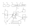
- FIG. 1 is a block diagram illustrating a mechanism for managing the pointing of a pointing device at a target device by means of the geographical information system according to the technique of the application FR1252873;
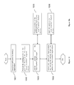
- FIG. 2 is a flowchart illustrating the algorithm executed by the geographical information system in the mechanism for managing the pointing illustrated in FIG. 1 (technique of the application FR1252873);
- FIGS. 3 and 3 a present the structure of a pointing device and of a central unit respectively according to one particular embodiment of the invention
- FIGS. 4 and 4 a present algorithms executed by the pointing device ( FIG. 4 ) and the geographical information system ( FIG. 4 a ) in a first example of association between digital objects according to the invention, in the particular context illustrated in FIG. 5 ;
- FIGS. 6 and 6 a present algorithms executed by the pointing device ( FIG. 6 ) and the geographical information system ( FIG. 6 a ) in a second example of association between digital objects according to the invention, in the particular context illustrated in FIG. 7 ;
- FIGS. 8 and 8 a present algorithms executed by the pointing device ( FIG. 8 ) and the geographical information system ( FIG. 8 a ) in a third example of association between digital objects according to the invention, in the particular context illustrated in FIG. 9 ;
- FIGS. 10 and 10 a present algorithms executed by the pointing device ( FIG. 10 ) and the geographical information system ( FIG. 10 a ) in a first technique according to the invention, to define the position of a digital object during its creation in the particular context illustrated in FIG. 11 ;
- FIGS. 12 and 12 a present the algorithms executed by the pointing device ( FIG. 12 ) and the geographical information system ( FIG. 12 a ) in a second technique according to the invention to define the position of a digital object during its creation, in the particular context illustrated in FIG. 13 .
- FIG. 1 we present a mechanism for managing the pointing of a pointing device at a target device (real object) by means of a geographical information system (GIS) according to the technique of the patent application FR1252873.
- GIS geographical information system
- the system comprises:
- the central unit 601 is for example connected to a network (local LAN or remote WAN as in a Cloud-type solution), by means of the network apparatus 401 .
- the central unit 601 is integrated into the network apparatus 401 .
- the central unit 601 can automatically complement and/or update its GIS data base 6010 .
- An administrator can also add or modify the data of the GIS data base.
- the locating modes 2010, 301, 302, 4010, 5010 are ultra-large-band (ULB) or ultra-wide-band (UWB) radio locating modules. They form a geo-location network to determine the distances between locating modules by using flight-time measurements. As soon as they are sufficient in number, it becomes possible to determine the position of each of the other locating modules by triangulation: using measurements of angles or measurements of relative distances.
- the locating modules are independent. They can detect and/or report their presence to neighboring modules (within signal range) and inform the central unit 601 thereof.
- the positions (3D x, y, z coordinates) of the apparatuses 301 , 302 are known (reference positions) and stored in the GIS data base of the central unit 601 .
- the positions of these apparatuses are computed automatically by the central unit 601 and stored in its GIS data base.
- the locating module 5010 included in the mobile terminal 501 communicates with the locating modules of the apparatuses 201 , 301 , 302 , 401 placed at known positions. This makes it possible to determine the distances between the locating module 5010 and the locating modules of the apparatuses 201 , 301 , 302 , 401 . Then, the central unit 601 obtains these distances (they are transmitted to it by the mobile terminal 501 and/or by at least one of the terminals 201 , 301 , 302 , 401 ).
- the central unit 601 determines the position of the mobile terminal 501 by triangulation according to the above-mentioned distances and the known positions of the locating modules embedded in the apparatuses 201 , 301 , 302 , 401 .
- a communications link is set up between, firstly, the central unit 601 and, secondly, the mobile terminal 501 and/or the apparatuses 201 , 301 , 302 .
- This link uses for example a local WiFi network or any other network accessed by the mobile terminal 501 and/or the apparatuses 201 , 301 , 302 .
- the central unit 601 can carry out real-time tracking of the movements of all the mobile terminals (especially the one referenced 501 in FIG. 1 ) that have a locating module.
- the central unit 601 takes account of the time dimension because the apparatuses (especially the mobile terminals) can be in motion.
- the central unit 601 is capable of managing several pointing devices simultaneously.
- the pointing device is the mobile terminal 501 and that the user is pointing it towards the video projector 502 .
- the axis of rotation of the pointing device is symbolized by the arrow in dashes referenced 7 in FIG. 1 .
- the central unit 601 obtains a piece of information on the position of the mobile terminal 510 (pointing device). As explained here above (see FIG. 1 ), using the apparatuses 201 , 301 , 302 , 401 , the position of the mobile terminal 501 is known and tracked in real time by the central unit 601 which centralizes all the information in its GIS data base 6010 .
- the central unit 601 obtains a piece of information on the orientation of the mobile terminal 501 .
- the mobile terminal 501 has one or more sensors (accelerometers, gyroscopes, compasses, etc.) by which it can deduce its orientation and transmit this piece of information on orientation to the computer 601 .
- the central unit 601 obtains a piece of information on the position of the apparatuses 101 to 107 , 201 , 301 , 302 , 401 (target devices). As explained here above (see FIG. 1 ), this is done by reading the content of the GIS data base 6010 of the central unit 601 .
- the central unit 601 determines the apparatus or the group of apparatuses pointed at by the mobile terminal 501 as a function of:
- the position and orientation in space of the mobile terminal 501 (pointing device) coupled with the positions of the other apparatuses (through the computer 601 ) are enough to determine the apparatuses being pointed at by the mobile terminal 501 .
- the association between the mobile terminal 501 (pointing device) and the being apparatuses pointed at can be used in various ways.
- the mobile terminal 501 can control an apparatus pointed at via the central unit 601 (hence without direct communication between the pointing device and the device pointed at).
- the central unit 601 integrates or relies on the data base GIS 6010 which contains a plurality of digital objects.
- Each digital object is defined in the data base by:
- the central unit 601 is adapted to determining whether the position of one of the objects is being pointed at by the pointing device 501 . This fact is determined according to the geometrical components of the digital objects and information on the position and orientation of the pointing device 501 .
- the invention uses the technique for managing pointing described in the patent application FR1252873.
- the central unit 601 and the pointing device 501 are adapted to enabling the creation of associations between the digital objects contained in the GIS data base 6010 and thus to forming associated groups of digital objects.
- the creation of an association between several digital objects comprises a sequence of steps, of which certain steps are performed by the pointing device 501 while others are performed by the central unit 601 .
- the central unit 601 stores, for example in a table, the identifiers of the associated digital objects as well as the following parameters (or only some of them);
- the present technique makes it possible to manage two categories of digital objects in the GIS data base 6010 (only the first category is mentioned in the patent application FR1252873).
- the first category of digital objects comprises a digital object corresponding to (i.e. objects that are models of) real objects of the environment in which the geographical information system is implemented.
- a digital object corresponding to (i.e. objects that are models of) real objects of the environment in which the geographical information system is implemented.
- the real objects considered i.e. objects whose models are contained in the GIS data base 6010
- the second category of digital objects comprises purely virtual digital objects, i.e. digital objects whose geometrical component defines a geographical position independently of the presence or non-presence of a real object at this geographical position.
- digital objects resulting from the modeling of a real object of the environment in which the geographical information system is implemented.
- the purely virtual objects possess a descriptive component defining one or more attributes such as, for example, multimedia objects (virtual memos, virtual table (for these virtual memos), videos, photos, etc.) or links (for example URL addresses or local addresses) enabling access to multimedia objects stored in other apparatuses (for example remote servers or local storage devices).
- attributes such as, for example, multimedia objects (virtual memos, virtual table (for these virtual memos), videos, photos, etc.) or links (for example URL addresses or local addresses) enabling access to multimedia objects stored in other apparatuses (for example remote servers or local storage devices).
- the central unit performs a step for verifying that at least one predetermined condition is verified (for example verifying that the identifier of the pointing device is part of a predetermined list) before authorizing the given pointing device to carry out the above-mentioned action or actions.
- a digital object forming part of a first group of associated digital objects can also form part of a second group of associated digital objects.
- the action of pointing to the position of this digital object makes it possible to obtain information and/or to act on the digital objects of the first group and on those of the second group (see here below the example of the “virtual memos table” digital object associated firstly with one or more “virtual memo” digital objects (to form a first group of associated digital objects) and secondly with a “refrigerator” digital object (to form a second group of associated digital objects).
- the novel concept (according to the present invention) of association between digital objects of the GIS data base 6010 can be implemented in any context in which a geographical information system (GIS) is adapted for use with at least one pointing device (according to a technique for managing pointing that is identical or not identical to the one described in the patent application FR1252873), and comprises a central unit accessing a data base containing a plurality of digital objects.
- GIS geographical information system
- FIGS. 4, 4 a and 5 we present a first example of association between digital objects according to the invention.
- FIGS. 4 and 4 a present the algorithms executed by the pointing device and the geographical information system respectively.
- FIG. 5 illustrates the particular context in which this first example is implemented.
- FIG. 5 can be distinguished from that of FIG. 1 solely in that it comprises an additional real object, namely a refrigerator 108 .
- the refrigerator 108 is a real object with which it is not possible to interact, either with the central unit 601 or with the pointing device 501 .
- the GIS data base 6010 contains a “refrigerator” digital object which is a model of the refrigerator (real object) 108 and which has a position (a geometrical component) that is the position of the refrigerator (real object) 108 .
- a step 41 via a man-machine interface of the pointing device 501 , the user selects the virtual memo (for example a list of errands) preliminarily created and stored in the pointing device 501 .
- the virtual memo for example a list of errands
- a step 42 the user orients the pointing device 501 towards the refrigerator 108 (along the axis of orientation symbolized by the arrow referenced 51 in FIG. 5 ) and asks the central unit 601 , via the man-machine interface of the pointing device 501 , to determine the digital object whose position is pointed at by the pointing device 501 .
- the central unit 601 determines that the digital object whose position is pointed at is the “refrigerator” digital object (model of the refrigerator 108 ) and gives the identifier to the pointing device 501 .
- a step 43 via the man-machine interface of the pointing device 501 the user asks the central unit 601 to create a “memo” digital object having a geometrical component defining a position identical to that of the “refrigerator” digital object and a descriptive component defining the virtual memo selected at the step 41 as a descriptive attribute.
- the pointing device 501 gives the central unit 601 the identifier of the “refrigerator” digital object.
- a step 46 the central unit 601 creates the “memo” digital object 109 and returns the identifier of this memo to the pointing device 501 .
- a step 44 via the man-machine interface of the pointing device 501 , the user asks the central unit 601 to create an association between the “memo” digital object and a “refrigerator” digital object. To this end, the pointing device 501 gives the central unit 601 the identifiers of both these digital objects.
- a step 47 the central unit 601 creates the association (symbolized by the arrow referenced 52 in FIG. 5 ) and returns a confirmation to the pointing device 501 .
- the parameters of this association enable for example the following subsequent operation.
- the central unit 601 determines that the digital object whose position is pointed at is the “refrigerator” digital object and that this digital object is associated with the “memo” digital object.
- the central unit cooperates with the pointing device 501 so that the man-machine interface of this device enables the user to view these two digital objects (for example by displaying their identifiers or their images or other icons associated with this identifier) and also to act on either or both of them.
- FIGS. 6, 6 a and 7 a second example of association between digital objects according to the invention is presented.
- FIGS. 6 and 6 a present the algorithm executed by the pointing device and the geographical information system respectively.
- FIG. 7 illustrates the particular context in which this second example is implemented.
- FIG. 7 is distinguished from that of FIG. 1 only in that it comprises an additional real object, namely a wall display 110 .
- the wall display 110 is a real object with which it is not possible to interact, whether with the central unit 601 or with the pointing device 501 .
- the GIS data base 6010 contains a “wall display” digital object which is a model of the wall display (real object) 110 and which has a position (geometrical component) that is the position of the wall display (real object) 110 .
- the GIS data base 6010 also contains a “video sequence” digital object (referenced 111 in FIG. 7 and represented in dashes to symbolize the fact that this is a purely virtual object according to the definition given further above).
- the “video sequence” digital object 111 has a geometrical component defining a position (distinct from that of the “wall display” digital object) and a descriptive component defining for example an access path to a particular video sequence (URL address or local address within a storage unit) as a descriptive attribute.
- a step 61 the user orients the pointing device 501 towards the position defined for the “video sequence” digital object 111 (along the axis of orientation symbolized by the arrow referenced 71 in FIG. 7 ) and via the man-machine interface of the pointing device 301 , asks the central unit 601 to determine the digital object whose position is pointed at by the pointing device 501 .
- the central unit 601 determines that the digital object whose position is pointed at is the “video sequence” digital object 111 and gives its identifier to the pointing device 501 .
- a step 62 via the man-machine interface of the pointing device 501 , the user handles a representation of the “video sequence” digital object 111 and stores its identifier.
- a step 63 the user orients the pointing device 501 towards the wall display 110 (along the axis of orientation symbolized by the arrow referenced 72 in FIG. 7 ) and, via the man-machine interface of the pointing device 501 , asks the central unit 601 to determine the digital object whose position is pointed at by the pointing device 501 .
- the central unit 601 determines that the digital object whose position is pointed at is the “wall display” digital object (model of the wall display 110 ).
- the central unit 601 gives the pointing device 501 the identifier of the “wall display” digital object.
- a step 64 the user asks the central unit 601 , via the man-machine interface of the pointing device 501 , * to create an association between the “video sequence” digital object 111 and the “wall display” digital object.
- the pointing device 501 gives the central unit 601 the identifiers of these two digital objects.
- a step 67 the central unit 601 creates the association (symbolized by the arrow referenced 73 of FIG. 5 ) and sends back a confirmation to the pointing device 501 .
- the parameters of this association enable for example the following subsequent operation.
- the central unit 601 determines that the digital object whose position is pointed at is the “wall display” digital object and that this digital object is associated with the “video sequence” digital object 111 .
- the central unit cooperates with the pointing device 501 so that the man-machine interface enables the user to view these two digital objects (for example by displaying their identifiers or their images or other icons associated with this identifier) and also to act on either or both of them (for example to activate the reading of the particular video sequence whose address is stored as a descriptive attribute of the “video sequence” digital object 111 ). Furthermore, during a shifting of the wall display 110 (and therefore the modification of the position defined for the “wall display” digital object), it is for example chosen not to modify the position defined for the “video sequence” digital object. It is assumed in this case that the “video sequence” digital object 111 is also associated with another “storage unit” digital object (model of a real object present in the environment).
- FIGS. 8, 8 a and 9 we present a third example of association between digital objects according to the invention.
- FIGS. 8 and 8 a present algorithms executed by the pointing device and the geographical information system respectively.
- FIG. 9 illustrates the particular context in which this third example is implemented.
- the GIS data base 6010 contains a “memo table” digital object (referenced 112 in FIG. 9 and shown in dashes, to symbolize the fact that it is a purely virtual object according to the definition given further above). It is defined especially by a position (a geometrical component) which, in this example, does not correspond to the position of a particular real object.
- a step 81 via a man-machine interface of the pointing device 501 , the user selects a virtual memo (for example a list of errands) preliminarily created and stored in the pointing device 501 .
- a virtual memo for example a list of errands
- a step 82 via the man-machine interface of the pointing device 501 , the user asks the central unit 601 to create a “memo” digital object with a geometrical component that is not defined at this stage and a descriptive component defining the virtual memo defined at the step 81 as a descriptive attribute.
- a step 85 the central unit 601 creates the “memo” digital object 113 and returns the identifier of this object to the pointing device 501 .
- a step 83 the user orients the pointing device 501 towards the position defined in the “memo table” digital object 112 (along the axis of orientation symbolized by the arrow referenced 91 in FIG. 9 ) and, via the man-machine interface of the pointing device 501 , it asks the central unit 601 to determine the digital object whose position is pointed at by the pointing device 501 .
- a step 86 according to the pointing technique described further above ( FIGS. 1 and 2 ), the central unit 601 determines that the digital object whose position is pointed at is the “memo table” digital object 112 and gives the identifier of this object to the pointing device 501 .
- a step 84 the user asks the central unit 601 , via the man-machine interface of the pointing device 501 , to create an association between the “memo” digital object 113 and the “memo table” digital object 112 .
- the pointing device 501 gives the identifiers of these two digital objects to the central unit 601 .
- a step 87 the central unit 601 creates the association (symbolized by the arrow referenced 92 in FIG. 9 ) and returns a confirmation to the pointing device 501 , While doing so, the central unit 601 defines the position of the “memo table” digital object 112 as the position of the “memo” digital object 113 .
- the parameters of this association enable for example the following subsequent operation.
- the central unit 601 determines that the digital object whose position is pointed at is the “memo table” digital object 112 and that this digital object is associated with the “memo” digital object 113 .
- the central unit cooperates with the pointing device 501 so that the man-machine interface of this device enables a user to view these two digital objects (for example by displaying their identifiers or their images or other icons associated with this identifier) and also to act on either or both of them.
- the man-machine interface of this device enables a user to view these two digital objects (for example by displaying their identifiers or their images or other icons associated with this identifier) and also to act on either or both of them.
- it is chosen for example to also modify the position defined for the “memo” digital object 113 in the same way. The choice made here is that of the simple augmentation of the data carried by the “memo table” digital object 112 .
- the “memo table” digital object 112 can itself be associated with the “refrigerator” digital object (model of the refrigerator 108 : cf. description in FIG. 5 ). In this case, during a shifting of the refrigerator 108 (and therefore the modification of the position defined for the “refrigerator” digital object), it is for example chosen to also modify in the same way the position defined for the “memo table” digital object 112 and therefore (by cascade effect between associations) the position defined for the “memo” digital object 113 .
- FIGS. 10, 10 a and 11 a first technique according to the invention is presented for defining the position of a digital object during its creation.
- FIGS. 10 and 10 a present algorithms executed by the pointing device and the geographical information system respectively.
- FIG. 11 illustrates the particular context in which this first position defining technique is implemented.
- a step 1001 via a man-machine interface of the pointing device 501 , the user launches an application for creating a digital object.
- a step 1002 the user shifts the pointing device 501 from an initial position (at the instant t 1 : pointing device 501 shown in solid lines in FIG. 11 ) up to a desired position for the new “local weather” digital object (at the instant t 2 : the pointing device 50 shown in dashes in FIG. 11 ).
- This desired position is for example the center of a window of the room in which the geographical information system is implemented.
- a step 1003 the user asks the central unit 601 , via a man-machine interface of the pointing device 501 , to compute the position desired for the new “local weather” digital object (position of the pointing device 501 at the instant t 2 ) and to create this new “local weather” digital object.
- the central unit 601 computes the desired position and creates the “local weather” digital object 114 (with a geometrical component defining this desired position) and then returns the identifier of this object to the pointing device 501 .
- a step 1004 via a man-machine interface of the pointing device 501 , the user selects the URL address of a local weather site and asks the central unit 601 to add this URL address to the “local weather” digital object 114 (as a descriptive attribute within the descriptive component). To this end, the pointing device 501 gives the central unit 601 the identifier of the “local weather” digital object 114 .
- a step 1006 the central unit 601 adds this URL address to the “local weather” digital object 114 and returns a confirmation to the pointing device 501 .
- the central unit 601 determines that the digital object whose position is pointed at is the “local weather” digital object 114 .
- the central unit cooperates with the pointing device 501 so that the man-machine interface of this device enables the user to access the above-mentioned local weather site.
- the mechanism described here above can be transposed to the creation and definition of the position of a digital object which is a model of a real object (for example the “refrigerator” digital object which is the model of the refrigerator (real object) 108 in FIG. 5 ).
- a mechanism (not shown), similar to the one described here above, makes it possible to modify the position defined for an already existing digital object.
- the user launches an application via a man/machine interface of the pointing device 501 to modify the position of a digital object.
- the user shifts the pointing device 500 up to a new position desired for the “local weather” digital object.
- the user asks the central unit 601 via a man/machine interface of the pointing device 501 to compute the new desired position and assign it to the “local weather” digital object.
- the central unit 601 computes the new desired position and assigns it to the “local weather” digital object (modifying the geometrical component) and then sends a confirmation back to the pointing device 501 .
- FIGS. 12, 12 a and 13 we present a second technique according to the invention for defining the position of a digital object during its creation.
- FIGS. 12 and 12 a present the algorithms executed by the pointing device and the geographical information system respectively.
- FIG. 13 illustrates the particular context in which this second technique for defining positions is implemented.
- FIG. 11 Apart from the above-mentioned modifications made to the central unit 601 and to the pointing device 501 so that they can create associations between digital objects, the context of FIG. 11 is not distinguished from that of FIG. 1 (there is no additional real object).
- a step 1201 via a man-machine interface of the pointing device 501 , the user launches an application for creating a digital object.
- a step 1202 from at least two distinct locations (corresponding to the instants t 1 and t 2 in FIG. 13 ), the user orients (i.e. physically points) the pointing device 501 towards a position desired for the new “local weather” digital object (in FIG. 13 , the pointing device 501 is shown in solid lines at the instant t 1 and in dotted lines at the instant t 2 ).
- the central unit 601 computes the axis of positioning of the pointing device 501 for each of the successive orientations (i.e. at the instants t 1 and 2 in this example).
- a step 1203 via a man-machine interface of the pointing device 501 , the user asks the central unit 601 to compute the desired position for the new “local weather” digital object and to create this new digital object.
- the central unit 601 computes the desired position and creates the “local weather” digital object 114 (with a geometrical component defining this desired position) and then returns the identifier of this object to the pointing device 501 .
- the steps 1204 and 1207 are identical to the steps 1004 and 1006 of FIGS. 10 and 10 a.
- FIGS. 3 and 3 a present the structure of a pointing device 501 and a central unit 601 respectively according to one particular embodiment of the invention.
- the pointing device 501 and the central unit 601 each comprise a RAM 33 , 33 ′, a processing unit 32 , 32 ′, equipped for example with a processor and driven by a computer program stored in a ROM 31 , 31 ′.
- the program code instructions of the computer are for example loaded into the RAM 33 , 33 ′ and then executed by the processor of the processing unit 32 , 32 ′ thus enabling:
- FIGS. 3 and 3 a illustrate only one particular way among several possible ways of performing the technique of the invention in the pointing device 501 and the central unit 601 . Indeed, in these entities 501 and 601 , the technique of the invention can be carried out equally well:
- the corresponding program i.e. the sequence of instructions
- a detachable storage medium such as for example a floppy disk, a CD ROM or a DVD ROM
- this storage medium being partially or totally readable by a computer or a processor.
Landscapes
- Engineering & Computer Science (AREA)
- Theoretical Computer Science (AREA)
- Physics & Mathematics (AREA)
- General Physics & Mathematics (AREA)
- General Engineering & Computer Science (AREA)
- Databases & Information Systems (AREA)
- Human Computer Interaction (AREA)
- Computer Networks & Wireless Communication (AREA)
- Remote Sensing (AREA)
- Data Mining & Analysis (AREA)
- Processing Or Creating Images (AREA)
- User Interface Of Digital Computer (AREA)
Applications Claiming Priority (2)
| Application Number | Priority Date | Filing Date | Title |
|---|---|---|---|
| FR1262596A FR3000242A1 (fr) | 2012-12-21 | 2012-12-21 | Procede de gestion d’un systeme d’information geographique adapte pour etre utilise avec au moins un dispositif de pointage, avec creation d’associations entre objets numeriques. |
| FR1262596 | 2012-12-21 |
Publications (2)
| Publication Number | Publication Date |
|---|---|
| US20140176312A1 US20140176312A1 (en) | 2014-06-26 |
| US10074266B2 true US10074266B2 (en) | 2018-09-11 |
Family
ID=47902221
Family Applications (1)
| Application Number | Title | Priority Date | Filing Date |
|---|---|---|---|
| US14/137,205 Active 2034-12-16 US10074266B2 (en) | 2012-12-21 | 2013-12-20 | Method for managing a system of geographical information adapted for use with at least one pointing device, with creation of associations between digital objects |
Country Status (3)
| Country | Link |
|---|---|
| US (1) | US10074266B2 (fr) |
| EP (1) | EP2746968A1 (fr) |
| FR (1) | FR3000242A1 (fr) |
Families Citing this family (2)
| Publication number | Priority date | Publication date | Assignee | Title |
|---|---|---|---|---|
| EP3349099A1 (fr) | 2017-01-13 | 2018-07-18 | Kai-Holger Brassel | Moyen de communication et d'informations immersif pour de très nombreux utilisateurs |
| CN113466788B (zh) * | 2021-07-20 | 2024-05-24 | 三星电子(中国)研发中心 | 指定物体的方法、装置和系统 |
Citations (39)
| Publication number | Priority date | Publication date | Assignee | Title |
|---|---|---|---|---|
| US5672820A (en) | 1995-05-16 | 1997-09-30 | Boeing North American, Inc. | Object location identification system for providing location data of an object being pointed at by a pointing device |
| US6199059B1 (en) | 1998-04-22 | 2001-03-06 | International Computex, Inc. | System and method for classifying and retrieving information with virtual object hierarchy |
| US20020140745A1 (en) | 2001-01-24 | 2002-10-03 | Ellenby Thomas William | Pointing systems for addressing objects |
| US20030020707A1 (en) * | 2001-06-27 | 2003-01-30 | Kangas Kari J. | User interface |
| US20030069693A1 (en) | 2001-01-16 | 2003-04-10 | Snapp Douglas N. | Geographic pointing device |
| US20030076357A1 (en) | 1998-10-27 | 2003-04-24 | Glaser Lawrence F. | Computer pointing device having theme identification means |
| DE10236260A1 (de) | 2002-08-07 | 2004-02-19 | Herpa Miniaturmodelle Gmbh | Verfahren zum Zuordnen einer geographischen Position |
| WO2004047011A2 (fr) | 2002-11-20 | 2004-06-03 | Koninklijke Philips Electronics N.V. | Systeme d'interface utilisateur fonde sur un dispositif de pointage |
| US20060109266A1 (en) | 2004-06-29 | 2006-05-25 | Sensable Technologies, Inc. | Apparatus and methods for haptic rendering using data in a graphics pipeline |
| US7103625B1 (en) | 1999-10-05 | 2006-09-05 | Veritas Operating Corporation | Virtual resource ID mapping |
| WO2007044975A2 (fr) | 2005-10-12 | 2007-04-19 | Google Inc. | Priorité d’affichage des entités dans un système d’information géographique réparti |
| US20070202472A1 (en) | 2004-04-02 | 2007-08-30 | Soeren Moritz | Device And Method For Simultaneously Representing Virtual And Real Ambient Information |
| US20080074423A1 (en) | 2006-09-25 | 2008-03-27 | Raytheon Company | Method and System for Displaying Graphical Objects on a Digital Map |
| US20080104019A1 (en) | 2006-10-26 | 2008-05-01 | Microsoft Corporation | Associating Geographic-Related Information with Objects |
| US20080201647A1 (en) | 2007-02-16 | 2008-08-21 | Sony Ericsson Mobile Communications Ab | Weather information in a calendar |
| US20080319655A1 (en) | 2005-10-17 | 2008-12-25 | Tele Atlas North America, Inc. | Method for Generating an Enhanced Map |
| US20100023878A1 (en) * | 2008-07-23 | 2010-01-28 | Yahoo! Inc. | Virtual notes in a reality overlay |
| US20100131192A1 (en) | 2008-11-21 | 2010-05-27 | Nicholas Clark | Method and System for Plotting a User's Position on a Display |
| US7743330B1 (en) | 2000-06-19 | 2010-06-22 | Comcast Ip Holdings I, Llc | Method and apparatus for placing virtual objects |
| US20100303293A1 (en) | 2008-12-22 | 2010-12-02 | David Caduff | System and Method for Linking Real-World Objects and Object Representations by Pointing |
| US20110013014A1 (en) | 2009-07-17 | 2011-01-20 | Sony Ericsson Mobile Communication Ab | Methods and arrangements for ascertaining a target position |
| US20110022661A1 (en) | 2009-07-21 | 2011-01-27 | Thomas Matthieu Alsina | Content Tagging Using Broadcast Device Information |
| US20110095978A1 (en) * | 2008-04-28 | 2011-04-28 | Armin Pehlivan | Remote control |
| US20110105220A1 (en) | 2009-10-29 | 2011-05-05 | Disney Enterprises, Inc. | Real-world items unlocking virtual items online and in video games |
| US20110110557A1 (en) | 2009-11-06 | 2011-05-12 | Nicholas Clark | Geo-locating an Object from Images or Videos |
| US20110124351A1 (en) | 2003-11-20 | 2011-05-26 | Intelligent Spatial Technologies, Inc. | Mobile Device and Geographic Information System Background and Summary of the Related Art |
| EP2336847A1 (fr) | 2009-12-15 | 2011-06-22 | Alcatel Lucent | Dispositif et procédé pour virtualiser un objet réel |
| US20110188760A1 (en) | 2010-02-03 | 2011-08-04 | Oculus Info Inc. | System and Method for Creating and Displaying Map Projections related to Real-Time Images |
| US20110279478A1 (en) * | 2008-10-23 | 2011-11-17 | Lokesh Bitra | Virtual Tagging Method and System |
| US20110302535A1 (en) | 2010-06-04 | 2011-12-08 | Thomson Licensing | Method for selection of an object in a virtual environment |
| US20110312311A1 (en) * | 2010-06-16 | 2011-12-22 | Qualcomm Incorporated | Methods and apparatuses for gesture based remote control |
| US20120127012A1 (en) | 2010-11-24 | 2012-05-24 | Samsung Electronics Co., Ltd. | Determining user intent from position and orientation information |
| US20120154108A1 (en) * | 2010-12-16 | 2012-06-21 | Optim Corporation | Portable terminal, method, and program of changing user interface |
| US20120212460A1 (en) * | 2011-02-23 | 2012-08-23 | Sony Corporation | Dynamic virtual remote tagging |
| US20120218263A1 (en) | 2009-10-12 | 2012-08-30 | Metaio Gmbh | Method for representing virtual information in a view of a real environment |
| EP2506118A1 (fr) | 2011-03-29 | 2012-10-03 | Sony Ericsson Mobile Communications AB | Pointeur virtuel |
| US20120297019A1 (en) | 2011-05-20 | 2012-11-22 | Tung-Sheng Ting | Method for controlling electronic devices and a hand-held device using the same |
| FR2985584A1 (fr) | 2012-03-29 | 2013-07-12 | France Telecom | Procede de gestion, par un equipement central, du pointage d'au moins un dispositif pointe par un dispositif de pointage |
| US8700304B1 (en) | 2009-05-21 | 2014-04-15 | Google Inc. | System and method of determining distances between geographic positions |
Family Cites Families (2)
| Publication number | Priority date | Publication date | Assignee | Title |
|---|---|---|---|---|
| FR1252873A (fr) | 1959-02-06 | 1961-02-03 | Gevaert Photo Prod Nv | Procédé pour le durcissement de compositions à base de gélatine notamment de compositions à base de gélatine entrant dans la constitution de matériels photographiques |
| US8275834B2 (en) * | 2009-09-14 | 2012-09-25 | Applied Research Associates, Inc. | Multi-modal, geo-tempo communications systems |
-
2012
- 2012-12-21 FR FR1262596A patent/FR3000242A1/fr not_active Withdrawn
-
2013
- 2013-12-18 EP EP13197913.0A patent/EP2746968A1/fr not_active Ceased
- 2013-12-20 US US14/137,205 patent/US10074266B2/en active Active
Patent Citations (40)
| Publication number | Priority date | Publication date | Assignee | Title |
|---|---|---|---|---|
| US5672820A (en) | 1995-05-16 | 1997-09-30 | Boeing North American, Inc. | Object location identification system for providing location data of an object being pointed at by a pointing device |
| US6199059B1 (en) | 1998-04-22 | 2001-03-06 | International Computex, Inc. | System and method for classifying and retrieving information with virtual object hierarchy |
| US20030076357A1 (en) | 1998-10-27 | 2003-04-24 | Glaser Lawrence F. | Computer pointing device having theme identification means |
| US7103625B1 (en) | 1999-10-05 | 2006-09-05 | Veritas Operating Corporation | Virtual resource ID mapping |
| US7743330B1 (en) | 2000-06-19 | 2010-06-22 | Comcast Ip Holdings I, Llc | Method and apparatus for placing virtual objects |
| CA2414717C (fr) | 2000-06-30 | 2012-10-16 | Discovery Communications, Inc. | Procede et appareil destines a placer des objets virtuels |
| US20030069693A1 (en) | 2001-01-16 | 2003-04-10 | Snapp Douglas N. | Geographic pointing device |
| US20020140745A1 (en) | 2001-01-24 | 2002-10-03 | Ellenby Thomas William | Pointing systems for addressing objects |
| US20030020707A1 (en) * | 2001-06-27 | 2003-01-30 | Kangas Kari J. | User interface |
| DE10236260A1 (de) | 2002-08-07 | 2004-02-19 | Herpa Miniaturmodelle Gmbh | Verfahren zum Zuordnen einer geographischen Position |
| WO2004047011A2 (fr) | 2002-11-20 | 2004-06-03 | Koninklijke Philips Electronics N.V. | Systeme d'interface utilisateur fonde sur un dispositif de pointage |
| US20110124351A1 (en) | 2003-11-20 | 2011-05-26 | Intelligent Spatial Technologies, Inc. | Mobile Device and Geographic Information System Background and Summary of the Related Art |
| US20070202472A1 (en) | 2004-04-02 | 2007-08-30 | Soeren Moritz | Device And Method For Simultaneously Representing Virtual And Real Ambient Information |
| US20060109266A1 (en) | 2004-06-29 | 2006-05-25 | Sensable Technologies, Inc. | Apparatus and methods for haptic rendering using data in a graphics pipeline |
| WO2007044975A2 (fr) | 2005-10-12 | 2007-04-19 | Google Inc. | Priorité d’affichage des entités dans un système d’information géographique réparti |
| US20080319655A1 (en) | 2005-10-17 | 2008-12-25 | Tele Atlas North America, Inc. | Method for Generating an Enhanced Map |
| US20080074423A1 (en) | 2006-09-25 | 2008-03-27 | Raytheon Company | Method and System for Displaying Graphical Objects on a Digital Map |
| US20080104019A1 (en) | 2006-10-26 | 2008-05-01 | Microsoft Corporation | Associating Geographic-Related Information with Objects |
| US20080201647A1 (en) | 2007-02-16 | 2008-08-21 | Sony Ericsson Mobile Communications Ab | Weather information in a calendar |
| US20110095978A1 (en) * | 2008-04-28 | 2011-04-28 | Armin Pehlivan | Remote control |
| US20100023878A1 (en) * | 2008-07-23 | 2010-01-28 | Yahoo! Inc. | Virtual notes in a reality overlay |
| US20110279478A1 (en) * | 2008-10-23 | 2011-11-17 | Lokesh Bitra | Virtual Tagging Method and System |
| US20100131192A1 (en) | 2008-11-21 | 2010-05-27 | Nicholas Clark | Method and System for Plotting a User's Position on a Display |
| US20100303293A1 (en) | 2008-12-22 | 2010-12-02 | David Caduff | System and Method for Linking Real-World Objects and Object Representations by Pointing |
| US8700304B1 (en) | 2009-05-21 | 2014-04-15 | Google Inc. | System and method of determining distances between geographic positions |
| US20110013014A1 (en) | 2009-07-17 | 2011-01-20 | Sony Ericsson Mobile Communication Ab | Methods and arrangements for ascertaining a target position |
| US20110022661A1 (en) | 2009-07-21 | 2011-01-27 | Thomas Matthieu Alsina | Content Tagging Using Broadcast Device Information |
| US20120218263A1 (en) | 2009-10-12 | 2012-08-30 | Metaio Gmbh | Method for representing virtual information in a view of a real environment |
| US20110105220A1 (en) | 2009-10-29 | 2011-05-05 | Disney Enterprises, Inc. | Real-world items unlocking virtual items online and in video games |
| US20110110557A1 (en) | 2009-11-06 | 2011-05-12 | Nicholas Clark | Geo-locating an Object from Images or Videos |
| EP2336847A1 (fr) | 2009-12-15 | 2011-06-22 | Alcatel Lucent | Dispositif et procédé pour virtualiser un objet réel |
| US20110188760A1 (en) | 2010-02-03 | 2011-08-04 | Oculus Info Inc. | System and Method for Creating and Displaying Map Projections related to Real-Time Images |
| US20110302535A1 (en) | 2010-06-04 | 2011-12-08 | Thomson Licensing | Method for selection of an object in a virtual environment |
| US20110312311A1 (en) * | 2010-06-16 | 2011-12-22 | Qualcomm Incorporated | Methods and apparatuses for gesture based remote control |
| US20120127012A1 (en) | 2010-11-24 | 2012-05-24 | Samsung Electronics Co., Ltd. | Determining user intent from position and orientation information |
| US20120154108A1 (en) * | 2010-12-16 | 2012-06-21 | Optim Corporation | Portable terminal, method, and program of changing user interface |
| US20120212460A1 (en) * | 2011-02-23 | 2012-08-23 | Sony Corporation | Dynamic virtual remote tagging |
| EP2506118A1 (fr) | 2011-03-29 | 2012-10-03 | Sony Ericsson Mobile Communications AB | Pointeur virtuel |
| US20120297019A1 (en) | 2011-05-20 | 2012-11-22 | Tung-Sheng Ting | Method for controlling electronic devices and a hand-held device using the same |
| FR2985584A1 (fr) | 2012-03-29 | 2013-07-12 | France Telecom | Procede de gestion, par un equipement central, du pointage d'au moins un dispositif pointe par un dispositif de pointage |
Non-Patent Citations (12)
| Title |
|---|
| English Translation of the Written Opinion dated Oct. 22, 2013 for corresponding French Patent Application No. 1262596 filed on Dec. 21, 2012. |
| Frank Steinicke et al., "Multimodal Interaction Metaphors for Manipulation of Distant Objects in Immersive Virtual Environments", Short Paper Proceedings of the 13th International Conference on central Europe on Computer Graphics, Visualization and Computer Vision (WSCG05), 2005, pp. 45-48, XP055082714. |
| French Search Report and Written Opinion dated Oct. 22, 2013 for corresponding French Patent application No. 12 62569 filed on Dec. 21, 2012. |
| French Search Report and Written Opinion dated Oct. 22, 2013 for corresponding French Patent Application No. 1262596 filed on Dec. 21, 2012. |
| Harmon R et al.: "The Virtual Annotation System", Virtual Reality Annual International Symposium, 1996, IEEE Comput. Soc., US, Mar. 30, 1996, pp. 239-245, 270, XP010157038. |
| HARMON R., PATTERSON W., RIBARSKY W., BOLTER J.: "The virtual annotation system", VIRTUAL REALITY ANNUAL INTERNATIONAL SYMPOSIUM, 1996., PROCEEDINGS OF THE IEEE 1996 SANTA CLARA, CA, USA 30 MARCH-3 APRIL 1996, LOS ALAMITOS, CA, USA,IEEE COMPUT. SOC., US, 30 March 1996 (1996-03-30) - 3 April 1996 (1996-04-03), US, pages 239 - 245, 270, XP010157038, ISBN: 978-0-8186-7295-8, DOI: 10.1109/VRAIS.1996.490533 |
| J. Richter et al.: "DeepaMehta-A Semantic Desktop", Proceedings of the 1st Workshop on the Semantic Desktop. 4th International Semantic Web Conference, Nov. 2005, pp. 9-12, XP055084855. |
| J�RG RICHTER, V�LKEL MAX, HALLER HEIKO: "DeepaMehta - A Semantic Desktop", PROCEEDINGS OF THE 1ST WORKSHOP ON THE SEMANTIC DESKTOP. 4TH INTERNATIONAL SEMANTIC WEB CONFERENCE, CEUR-WS, 1 November 2005 (2005-11-01), XP055084855 |
| KRAAK M.-J.: "ONTEGRATING MULTIMEDIA IN GEOGRAPHICAL INFORMATION SYSTEMS.", IEEE MULTIMEDIA., IEEE SERVICE CENTER, NEW YORK, NY., US, vol. 03., no. 02., 1 June 1996 (1996-06-01), US, pages 59 - 65., XP000594156, ISSN: 1070-986X, DOI: 10.1109/93.502295 |
| Kraak M-J, "Integrating Multimedia in Geographical Information Systems", IEEE Multimedia, IEEE Service Center, New York, NY, US, vol. 3, No. 2, Jun. 1996 (Jun. 1996), pp. 59-65, XP000594156. |
| Timo Ropinksi et al., "Visual Exploration of Seismic Volume Datasets", Proceedings of the 14th International Conference in Central Europe on Computer Graphics, Visualization and Computer Vision (WSCG06), vol. 14, 2006, pp. 73-80, XP055082305. |
| TIMO ROPINSKI, STEINICKE FRANK, HINRICHS KLAUS: "Visual Exploration of Seismic Volume Datasets", PROCEEDINGS OF THE 14TH INTERNATIONAL CONFERENCE IN CENTRAL EUROPE ON COMPUTER GRAPHICS, VISUALIZATION AND COMPUTER VISION (WSCG06), vol. 14, 1 January 2006 (2006-01-01), pages 73 - 80, XP055082305, ISSN: 12136972 |
Also Published As
| Publication number | Publication date |
|---|---|
| EP2746968A1 (fr) | 2014-06-25 |
| US20140176312A1 (en) | 2014-06-26 |
| FR3000242A1 (fr) | 2014-06-27 |
Similar Documents
| Publication | Publication Date | Title |
|---|---|---|
| US11516349B2 (en) | IP carrier peering with DNS recursion zone | |
| CN104468327B (zh) | 一种群组加入方法、装置及系统 | |
| CN103546294B (zh) | 门禁授权方法、装置及设备 | |
| US20190281473A1 (en) | Haptic augmented reality assisted self-service for wireless networks | |
| US20220191295A1 (en) | Synchronizing multiple user devices in an immersive media environment using time-of-flight light patterns | |
| US20220217129A1 (en) | Isolating networks and credentials using on-demand port forwarding | |
| EP3671411B1 (fr) | Système de réalité augmentée (ar) adaptée à la localisation et procédé d'interopérabilité d'applications ar | |
| KR20190051326A (ko) | 블록 체인 기반 사물 인터넷 장치 제어 시스템 및 방법 | |
| KR102470837B1 (ko) | 3차원 공간에서의 cctv 영상 범위를 이용한 공간 분석 방법 | |
| US10587837B2 (en) | Image obtaining method, controlled device, and server | |
| WO2017218309A1 (fr) | Granularité de lien de partage de fichier électronique | |
| US20240080366A1 (en) | Systems and methods for controlling network devices in an augmented reality environment | |
| CN105050038B (zh) | 一种监控移动终端位置信息的方法、装置及系统 | |
| CN103997479A (zh) | 一种非对称服务ip代理方法和设备 | |
| US10074266B2 (en) | Method for managing a system of geographical information adapted for use with at least one pointing device, with creation of associations between digital objects | |
| US20120210399A1 (en) | Location-enabled access control lists for real-world devices | |
| US10970882B2 (en) | Method for scalable volumetric video coding | |
| US20250285394A1 (en) | Systems and methods for managing network devices using augmented reality | |
| US20140188877A1 (en) | Method for Managing a System of Geographical Information Adapted for Use With at Least One Pointing Device, with Creation of Purely Virtual Digital Objects | |
| Shin et al. | S/W Based Frame‐Level Synchronization for Irregular Screen Processing System | |
| US20150032742A1 (en) | Communication management system, communication terminal, communication system, and recording medium | |
| US12132634B2 (en) | Managing extended reality experience | |
| US20250330773A1 (en) | System and method for verifying presence at location | |
| US9600520B2 (en) | Method and system for prospective search query management | |
| WO2024017195A1 (fr) | Procédé et appareil de gestion de numéro d'identification personnel (pin), premier terminal et premier dispositif |
Legal Events
| Date | Code | Title | Description |
|---|---|---|---|
| AS | Assignment |
Owner name: ORANGE, FRANCE Free format text: ASSIGNMENT OF ASSIGNORS INTEREST;ASSIGNORS:ROMANO, PHILIPPE;GIRAUDON, VINCENT;REEL/FRAME:032637/0858 Effective date: 20140108 |
|
| STCF | Information on status: patent grant |
Free format text: PATENTED CASE |
|
| MAFP | Maintenance fee payment |
Free format text: PAYMENT OF MAINTENANCE FEE, 4TH YEAR, LARGE ENTITY (ORIGINAL EVENT CODE: M1551); ENTITY STATUS OF PATENT OWNER: LARGE ENTITY Year of fee payment: 4 |
|
| MAFP | Maintenance fee payment |
Free format text: PAYMENT OF MAINTENANCE FEE, 8TH YEAR, LARGE ENTITY (ORIGINAL EVENT CODE: M1552); ENTITY STATUS OF PATENT OWNER: LARGE ENTITY Year of fee payment: 8 |