US8321128B2 - Method for correcting map matching and navigation system implementing the method - Google Patents
Method for correcting map matching and navigation system implementing the method Download PDFInfo
- Publication number
- US8321128B2 US8321128B2 US12/599,959 US59995907A US8321128B2 US 8321128 B2 US8321128 B2 US 8321128B2 US 59995907 A US59995907 A US 59995907A US 8321128 B2 US8321128 B2 US 8321128B2
- Authority
- US
- United States
- Prior art keywords
- vehicle
- navigation system
- map matching
- information
- matching correction
- Prior art date
- Legal status (The legal status is an assumption and is not a legal conclusion. Google has not performed a legal analysis and makes no representation as to the accuracy of the status listed.)
- Expired - Fee Related, expires
Links
Images




Classifications
-
- G—PHYSICS
- G06—COMPUTING OR CALCULATING; COUNTING
- G06Q—INFORMATION AND COMMUNICATION TECHNOLOGY [ICT] SPECIALLY ADAPTED FOR ADMINISTRATIVE, COMMERCIAL, FINANCIAL, MANAGERIAL OR SUPERVISORY PURPOSES; SYSTEMS OR METHODS SPECIALLY ADAPTED FOR ADMINISTRATIVE, COMMERCIAL, FINANCIAL, MANAGERIAL OR SUPERVISORY PURPOSES, NOT OTHERWISE PROVIDED FOR
- G06Q50/00—Information and communication technology [ICT] specially adapted for implementation of business processes of specific business sectors, e.g. utilities or tourism
- G06Q50/40—Business processes related to the transportation industry
-
- G—PHYSICS
- G01—MEASURING; TESTING
- G01C—MEASURING DISTANCES, LEVELS OR BEARINGS; SURVEYING; NAVIGATION; GYROSCOPIC INSTRUMENTS; PHOTOGRAMMETRY OR VIDEOGRAMMETRY
- G01C21/00—Navigation; Navigational instruments not provided for in groups G01C1/00 - G01C19/00
- G01C21/26—Navigation; Navigational instruments not provided for in groups G01C1/00 - G01C19/00 specially adapted for navigation in a road network
- G01C21/28—Navigation; Navigational instruments not provided for in groups G01C1/00 - G01C19/00 specially adapted for navigation in a road network with correlation of data from several navigational instruments
- G01C21/30—Map- or contour-matching
-
- G—PHYSICS
- G01—MEASURING; TESTING
- G01C—MEASURING DISTANCES, LEVELS OR BEARINGS; SURVEYING; NAVIGATION; GYROSCOPIC INSTRUMENTS; PHOTOGRAMMETRY OR VIDEOGRAMMETRY
- G01C21/00—Navigation; Navigational instruments not provided for in groups G01C1/00 - G01C19/00
- G01C21/26—Navigation; Navigational instruments not provided for in groups G01C1/00 - G01C19/00 specially adapted for navigation in a road network
-
- G—PHYSICS
- G01—MEASURING; TESTING
- G01S—RADIO DIRECTION-FINDING; RADIO NAVIGATION; DETERMINING DISTANCE OR VELOCITY BY USE OF RADIO WAVES; LOCATING OR PRESENCE-DETECTING BY USE OF THE REFLECTION OR RERADIATION OF RADIO WAVES; ANALOGOUS ARRANGEMENTS USING OTHER WAVES
- G01S19/00—Satellite radio beacon positioning systems; Determining position, velocity or attitude using signals transmitted by such systems
- G01S19/38—Determining a navigation solution using signals transmitted by a satellite radio beacon positioning system
-
- G—PHYSICS
- G05—CONTROLLING; REGULATING
- G05D—SYSTEMS FOR CONTROLLING OR REGULATING NON-ELECTRIC VARIABLES
- G05D1/00—Control of position, course, altitude or attitude of land, water, air or space vehicles, e.g. using automatic pilots
- G05D1/20—Control system inputs
- G05D1/24—Arrangements for determining position or orientation
- G05D1/247—Arrangements for determining position or orientation using signals provided by artificial sources external to the vehicle, e.g. navigation beacons
- G05D1/248—Arrangements for determining position or orientation using signals provided by artificial sources external to the vehicle, e.g. navigation beacons generated by satellites, e.g. GPS
Definitions
- the present disclosure relates to a method of correcting a map matching and a navigation system for implementing the method of correcting the map matching.
- navigation systems are systems to provide navigation information for driving of vehicles, such as cars, using artificial satellites.
- the navigation systems are referred to as automatic navigation systems.
- the navigation systems receive, by using GPS receivers, Global Positioning System (GPS) information from GPS satellites floating above the earth, and calculate locations of the navigation systems themselves based on the received GPS information.
- GPS Global Positioning System
- the navigation systems may provide various information helpful for driving of vehicles by notifying users of a current vehicle location based on location information of the navigation systems themselves, calculating moving routes to desired destinations, guiding the users according to the moving routes, and the like.
- the navigation systems receive the GPS information including latitude information and longitude information from the GPS satellites, and calculate and output location information of vehicles. Also, the navigation systems perform a map matching of the outputted location information with map information such as geographical features, roads, buildings, and the like, being disposing according to latitudes and longitudes, and show moving routes from current locations to destinations which the users desire. The navigation systems perform road guidance showing the moving routes to the destinations by using maps on reduced scales fixed on display apparatuses, and notify the users of moving directions at intersections by using images or voices.
- the navigation systems cannot accurately perform the road guidance due to errors between the GPS information and the map information when the map matching is performed by using only the GPS information.
- the navigation systems may generate errors between actual locations of the vehicles and locations of the vehicles on the navigation systems when the map matching is performed.
- vehicles actually leave moving routes especially when the vehicles leave the moving routes from similar-angled links, that is, roads
- the navigation systems cannot recognize whether the vehicles is driven/stopped in the areas where the GPS information cannot be received.
- the present disclosure provides a method of correcting a map matching and a navigation system for implementing the method which can minimize an error between Global Positioning System (GPS) information and map information by using an acceleration sensor of a vehicle, thereby quickly and accurately performing the map matching.
- GPS Global Positioning System
- the present disclosure also provides a method of correcting a map matching and a navigation system for implementing the method which can quickly and accurately perform the map matching in various driving environments by using an acceleration sensor.
- a method of correcting a map matching including: determining whether a vehicle turns by using an acceleration sensor; and performing a map matching correction by using the determination of whether the vehicle turns and Global Positioning System (GPS) information.
- GPS Global Positioning System
- a method of correcting a map matching including: checking whether a vehicle leaves a route; determining whether the vehicle enters an uphill/downhill road by using an acceleration sensor when the vehicle leaves the route; and performing a map matching correction by using the determination of whether the vehicle enters the uphill/downhill road and GPS information.
- a method of correcting map matching including: checking whether GPS information can be received; determining whether a vehicle is driven/stopped by using an acceleration sensor when the GPS information cannot be received; and performing a map matching correction by using the determination of whether the vehicle is driven/stopped.
- a navigation system including: a turn determination unit determining whether a vehicle turns by using an acceleration sensor; and a map matching correction unit performing a map matching correction by using the determination of whether the vehicle turns and GPS information.
- a navigation system including: a road entrance determination unit checking whether a vehicle leaves a route, and determining whether the vehicle enters an uphill/downhill road by using an acceleration sensor when the vehicle leaves the route; and a map matching correction unit performing a map matching correction by using the determination of whether the vehicle enters the uphill/downhill road and GPS information.
- a navigation system including: a drive/stop determination unit checking whether GPS information can be received, and determining whether a vehicle is driven/stopped by using an acceleration sensor when the GPS information cannot be received; and a map matching correction unit performing a map matching correction by using the determination of whether the vehicle is driven/stopped.
- FIG. 1 is a flowchart illustrating a method of correcting a map matching according to an exemplary embodiment of the present disclosure
- FIG. 2 illustrates an example of correcting a map matching according to an exemplary embodiment of the present disclosure
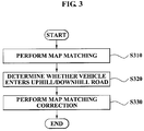
- FIG. 3 is a flowchart illustrating a method of correcting a map matching according to another exemplary embodiment of the present disclosure
- FIG. 4 illustrates an example of correcting a map matching according to another exemplary embodiment of the present disclosure
- FIG. 5 is a flowchart illustrating a method of correcting a map matching according to still another exemplary embodiment of the present disclosure
- FIG. 6 is a block diagram illustrating a navigation system according to an exemplary embodiment of the present disclosure.
- FIG. 7 is a block diagram illustrating a navigation system according to another exemplary embodiment of the present disclosure.
- FIG. 8 is a block diagram illustrating a navigation system according to still another exemplary embodiment of the present disclosure.
- a navigation system of the present disclosure enables a navigator to accurately perform a map matching by using an acceleration sensor.
- the navigation system may accurately and quickly perform the map matching by determining a vehicle turns when the vehicle turns left/right, or determining whether the vehicle enters an uphill/downhill road, or determining whether the vehicle is driven/stopped by using the acceleration sensor.
- the navigation system may be realized in ordinary navigation systems.
- the acceleration sensor may be mounted in the navigation system.
- FIG. 1 is a flowchart illustrating a method of correcting a map matching according to an exemplary embodiment of the present disclosure.
- a navigation system may perform a map matching of current vehicle location information with map information by using Global Positioning System (GPS) information and the map information in operation S 110 .
- GPS Global Positioning System
- the navigation system may interoperate the GPS information and the map information, and correct a vehicle location on the map information when distance information and direction information of actually driving the vehicle are different from an image shown on the map information.
- the navigation system may perform a map matching correction by determining whether the vehicle turns and applying a result of the determination to the map matching in order to perform the accurate correction. This is described in detail below.
- the navigation system may interoperate with the map matching, and determine whether the vehicle turns by using an acceleration sensor in operation S 120 . Specifically, after measuring an inclination of the vehicle by using the acceleration sensor, the navigation system may determine whether the vehicle turns based on the measured inclination.
- the navigation system may determine that the vehicle turns right when the measured inclination indicates that the vehicle is inclined to a left-hand side. Conversely, the navigation system may determine that the vehicle turns left when the measured inclination indicates that the vehicle is inclined to a right-hand side.
- the navigation system may determine whether a GPS angle shows a left/right rotation form.
- the navigation system may determine that the vehicle does not turn and a lane of the vehicle is changed when the GPS angle shows the left/right rotation form.
- the navigation system may accurately determine whether the vehicle turns by using the acceleration sensor and the GPS angle.
- the GPS angle may be realized on a screen of the navigation system when the vehicle is driven, and signify that the map information shows an angle of a left/right rotation by establishing a vehicle driving direction as a standard.
- the navigation system may perform a map matching correction by using the determination of whether the vehicle turns and GPS information. Specifically, the navigation system may recognize current location information of the vehicle by using the GPS information when the vehicle turns, and perform the map matching correction by using the recognized location information.
- the navigation system may recognize current location information of the vehicle by using the GPS information of the vehicle when it is determined that the vehicle turns right, and perform the map matching correction by using the recognized location information so that the vehicle realized on the screen of the navigation system may immediately turn right. Also, the navigation system may recognize current location information of the vehicle when it is determined that the vehicle turns left, and perform the map matching correction by using the recognized location information so that the vehicle realized on the screen of the navigation system may immediately turn left.
- FIG. 2 illustrates an example of correcting a map matching according to an exemplary embodiment of the present disclosure.
- a navigation system performs a map matching in an existing method, and starts to read a value of an acceleration sensor concerning whether a vehicle turns before crossroads. Next, the navigation system recognizes whether the vehicle turns by using the value concerning whether the vehicle turns. Also, when it is determined that the vehicle turns as a result of the recognition, the navigation system immediately turns the vehicle of the navigation system.
- a point in time when the navigation system determines whether the vehicle turns may be about 10 seconds as illustrated in reference number 210 of FIG. 2 .
- a point in time when the navigation system turns the vehicle of the navigation system may be about 11 seconds by reflecting turn information of the vehicle in the map matching and performing the map matching correction as illustrated in reference number 220 .
- a point in time when the navigation system turns the vehicle of the navigation system by using an existing map matching method of not using the acceleration sensor may be about 13 or 14 seconds, 2 or 3 seconds slower than an exemplary embodiment of the present disclosure as illustrated in reference number 230 .
- the navigation system does not determine whether the vehicle turns by using only the acceleration sensor, and determines whether a GPS angle shows a slight left/right rotation form, thereby improving accuracy of the map matching. Specifically, the navigation system may accurately determine whether the vehicle turns by using the acceleration sensor and the GPS angle. Accordingly, the navigation system may prevent a misjudgment of determining that the vehicle turns when a lane of the vehicle is changed.
- the navigation system may perform the accurate map matching by determining whether the vehicle turns by using the acceleration sensor, and applying a result of the determination to the map matching. Also, the navigation system according to the exemplary embodiment of the present disclosure enables vehicle driving information of the navigation system to quickly react to actual vehicle driving information. Also, the navigation system according to the exemplary embodiment of the present disclosure may accurately determine whether the vehicle turns by using the acceleration sensor and the GPS angle.
- FIG. 3 is a flowchart illustrating a method of correcting a map matching according to another exemplary embodiment of the present disclosure.
- a navigation system may perform a map matching of current vehicle location information with map information by using GPS information and the map information in operation S 310 .
- the navigation system may interoperate the GPS information and the map information, and correct a vehicle location on the map information when distance information of actual vehicle driving and direction information of actual vehicle driving are different from an image shown on the map information.
- the navigation system may perform a map matching correction by determining whether the vehicle goes up or goes down, and applying a result of the determination to the map matching in order to perform the accurate correction. This is described in detail below.
- the navigation system may check whether the vehicle leaves a route. When it is checked that the vehicle leaves the route, the navigation system may interoperate with the map matching, and determine whether the vehicle enters an uphill/downhill road by using an acceleration sensor in operation S 320 . Specifically, the navigation system may check whether the vehicle leaves the route and enters another route disregarding the driving route currently provided by the navigation system. When the vehicle leaves the route and enters the other route, the navigation system may determine whether the vehicle goes up through the overpass, the entrance ramp, and the like, or goes down through the underpass, the exit ramp, and the like by using an acceleration sensor.
- the navigation system may measure an inclination of the vehicle by using the acceleration sensor, and determine whether the vehicle enters the uphill/downhill road based on the measured inclination. Specifically, the navigation system may determine that the vehicle enters the uphill road when the measured inclination indicates that the vehicle is inclined to a back side. Conversely, the navigation system may determine that the vehicle enters the downhill road when the measured inclination indicates that the vehicle is inclined to a front side.
- the navigation system may perform a map matching correction by using the determination of whether the vehicle enters the uphill/downhill road and GPS information. Specifically, the navigation system may recognize current location information of the vehicle by using the GPS information when the vehicle enters the uphill/downhill road, and perform the map matching correction by using the recognized location information.
- a vehicle driver may drive the vehicle to the entrance ramp being an entrance road to an express highway at an express highway interchange disregarding a straight road, that is, a national highway provided by the navigation system.
- the vehicle driver may drive the vehicle leaving an original route.
- the navigation system may re-search route information of the vehicle by using the determination of whether the vehicle enters the uphill/downhill road and the GPS information, and perform the map matching correction so that the vehicle realized in the navigation system may enter the entrance ramp according to the re-searched route information.
- FIG. 4 illustrates an example of correcting a map matching according to another exemplary embodiment of the present disclosure.
- a navigation system performs a map matching in an existing method, and starts to read a value concerning whether a vehicle enters a road by using an acceleration sensor when the vehicle leaves a driving route of the navigation system.
- the navigation system recognizes whether the vehicle enters an uphill/downhill road by using the value concerning whether the vehicle enters the road.
- the navigation system enables the vehicle realized in the navigation system to leave the current driving route, and quickly re-searches a corrected route, that is, the actual driving route of the vehicle. Accordingly, the navigation system enables a driver to quickly receive a road guide to the corrected route even when the vehicle leaves the route.
- a point in time when the navigation system enables the vehicle realized in the navigation system to leave the route may be an approximate point in time when the vehicle passes a forked road divided into an original route, that is, a national highway or an express highway, and a leaving route, that is, an express highway ramp as illustrated in 420 and 450 of FIG. 4 . It may be understood that the point in time is earlier than points in time of leaving the route when an existing map matching is performed, that is, 430 and 460 . Accordingly, the navigation system may perform the map matching more quickly and accurately than the existing map matching.
- the navigation system may also apply the above-described logic, that is, determining whether the vehicle enters the uphill/downhill road by using the acceleration sensor, to a side road of an overpass/underpass, and perform a map matching correction in order to quickly re-search vehicle route information of the navigation system by using actual route information of the vehicle, that is, the uphill/downhill road. Accordingly, the navigation system may quickly and accurately perform a route re-search for the map matching correction when the vehicle leaves the route.
- FIG. 5 is a flowchart illustrating a method of correcting a map matching according to still another exemplary embodiment of the present disclosure.
- a navigation system may perform a map matching of current vehicle location information with map information by using GPS information and the map information in operation S 510 .
- the navigation system may interoperate the GPS information and the map information, and correct a vehicle location on the map information when distance information of actual vehicle driving and direction information of actual vehicle driving are different from an image shown on the map information.
- the navigation system may perform the map matching correction by determining whether the vehicle is driven/stopped, and applying a result of the determination to the map matching in order to perform the accurate map matching correction. This is described in detail below.
- the navigation system may check whether GPS information can be received by the vehicle. When it is checked that the GPS information cannot be received, the navigation system may interoperate with the map matching, and determine whether the vehicle is driven/stopped by using an acceleration sensor in operation S 520 . Specifically, the navigation system may determine whether the vehicle is driven/stopped by using an output value of the acceleration sensor in the area where the GPS information cannot be received such as a tunnel, and the like.
- the navigation system may measure speed information of the vehicle by using the acceleration sensor, and determine whether the vehicle is driven/stopped based on the measured speed information. For example, when the measured speed information is 0, the navigation system may determine that the vehicle is stopped. Conversely, when the measured speed information is different from 0, the navigation system may determine that the vehicle is driven.
- the navigation system may perform a map matching correction by using the determination of whether the vehicle is driven/stopped. Specifically, the navigation system may perform the map matching correction by using the speed information of the vehicle until the GPS information can be received by the vehicle when the vehicle is driven/stopped.
- the navigation system may measure speed information of the vehicle at a point in time of entering the tunnel.
- the navigation system may store the measured speed information in a storage device.
- the navigation system may have the storage device built-in.
- the navigation system may perform the map matching correction by applying the measured speed information in the area where the GPS information cannot be received such as a tunnel, and the like.
- the navigation system may maintain a state of applying speed information ‘0’ to the vehicle of realized in the navigation system and stopping the vehicle.
- the navigation system may perform the map matching correction by extracting the speed information of the vehicle from the storage device and applying the extracted speed information to the vehicle of the navigation system.
- the navigation system may accurately perform the map matching correction by using the acceleration sensor in the area where the GPS information cannot be received such as a tunnel, and the like, thereby minimizing a map matching error in the area where the GPS information cannot be received.
- the vehicle is actually stopped in an area where there are many high-rise buildings or under an overpass, it may be shown that the vehicle of the navigation system is driven. Since the navigation system may determine the vehicle is stopped by using the acceleration sensor in the above-described area, that is, in the area where there are many high-rise buildings or under the overpass, a malfunction of the navigation system due to a reflected wave by buildings, and the like, that is, a multipath, may be prevented.
- the exemplary embodiments of the present disclosure include computer-readable media including program instructions to implement various operations embodied by a computer.
- the media may also include, alone or in combination with the program instructions, data files, data structures, and the like.
- the media and program instructions may be those specially designed and constructed for the purposes of the present disclosure, or they may be of the kind well-known and available to those having skill in the computer software arts.
- Examples of computer-readable media include magnetic media such as hard disks, floppy disks, and magnetic tape; optical media such as CD ROM disks and DVD; magneto-optical media such as optical disks; and hardware devices that are specially configured to store and perform program instructions, such as read-only memory (ROM), random access memory (RAM), flash memory, and the like.
- Examples of program instructions include both machine code, such as produced by a compiler, and files containing higher level code that may be executed by the computer using an interpreter.
- FIG. 6 is a block diagram illustrating a navigation system according to an exemplary embodiment of the present disclosure.
- the navigation system may include a map matching unit 610 , a turn determination unit 620 , and a map matching correction unit 630 .
- the map matching unit 610 may perform a map matching of current vehicle location information with map information by using GPS information and the map information. Specifically, the map matching unit 610 may interoperate the GPS information and the map information, and correct a vehicle location on the map information when distance information and direction information of actually driving the vehicle are different from an image shown on the map information.
- the turn determination unit 620 may interoperate with the map matching, and determine whether the vehicle turns by using an acceleration sensor. Specifically, after measuring an inclination of the vehicle by using the acceleration sensor, the turn determination unit 620 may determine whether the vehicle turns based on the measured inclination.
- the turn determination unit 620 may determine that the vehicle turns right when the measured inclination indicates that the vehicle is inclined to a left-hand side. Conversely, the turn determination unit 620 may determine that the vehicle turns left when the measured inclination indicates that the vehicle is inclined to a right-hand side.
- the turn determination unit 620 may determine whether a GPS angle shows a left/right rotation form.
- the turn determination unit 620 may determine that the vehicle does not turn and a lane of the vehicle is changed when the GPS angle shows the left/right rotation form. Specifically, the turn determination unit 620 may accurately determine whether the vehicle turns by using the acceleration sensor and the GPS angle.
- the GPS angle may be realized on a screen of the navigation system when the vehicle is driven, and signify that the map information shows an angle of a left/right rotation by establishing a vehicle driving direction as a standard.
- the map matching correction unit 630 may perform a map matching correction by using the determination of whether the vehicle turns and GPS information. Specifically, the map matching correction unit 630 may recognize current location information of the vehicle by using the GPS information when the vehicle turns, and perform the map matching correction by using the recognized location information.
- the map matching correction unit 630 may recognize current location information of the vehicle by using the GPS information of the vehicle when it is determined that the vehicle turns right, and perform the map matching correction by using the recognized location information so that the vehicle realized on the screen of the navigation system may immediately turn right. Also, the map matching correction unit 630 may recognize current location information of the vehicle when it is determined that the vehicle turns left, and perform the map matching correction by using the recognized location information so that the vehicle realized on the screen of the navigation system may immediately turn left.
- FIG. 7 is a block diagram illustrating a navigation system according to another exemplary embodiment of the present disclosure.
- the navigation system may include a map matching unit 710 , a road entrance determination unit 720 , and a map matching correction unit 730 .
- the map matching unit 710 may perform a map matching of current vehicle location information with map information by using GPS information and the map information. Specifically, the map matching unit 710 may interoperate the GPS information and the map information, and correct a vehicle location on the map information when distance information and direction information of actually driving the vehicle are different from an image shown on the map information.
- the road entrance determination unit 720 may check whether the vehicle leaves a route. When it is checked that the vehicle leaves the route, the road entrance determination unit 720 may interoperate with the map matching, and determine whether the vehicle enters an uphill/downhill road by using an acceleration sensor.
- the road entrance determination unit 720 may check whether the vehicle leaves the route and enters another route disregarding the driving route currently provided by the navigation system. When the vehicle leaves the route and enters the other route, the road entrance determination unit 720 may determine whether the vehicle goes up through the overpass, the entrance ramp, and the like, or goes down through the underpass, the exit ramp, and the like by using an acceleration sensor.
- the road entrance determination unit 720 may measure an inclination of the vehicle by using the acceleration sensor, and determine whether the vehicle enters the uphill/downhill road based on the measured inclination. Specifically, the road entrance determination unit 720 may determine that the vehicle enters the uphill road when the measured inclination indicates that the vehicle is inclined to a back side. Conversely, the navigation system may determine that the vehicle enters the downhill road when the measured inclination indicates that the vehicle is inclined to a front side.
- the map matching correction unit 730 may perform a map matching correction by using the determination of whether the vehicle enters the uphill/downhill road and GPS information. Specifically, the map matching correction unit 730 may recognize current location information of the vehicle by using the GPS information when the vehicle enters the uphill/downhill road, and perform the map matching correction by using the recognized location information.
- a vehicle driver may drive the vehicle to the entrance ramp being an entrance road to an express highway at an express highway interchange disregarding a straight road, that is, a national highway provided by the navigation system.
- the vehicle driver may drive the vehicle leaving an original route.
- the map matching correction unit 730 may re-search route information of the vehicle by using the determination of whether the vehicle enters the uphill/downhill road and the GPS information, and perform the map matching correction so that the vehicle realized in the navigation system may enter the entrance ramp according to the re-searched route information.
- FIG. 8 is a block diagram illustrating a navigation system according to still another exemplary embodiment of the present disclosure.
- the navigation system may include a map matching unit 810 , a drive/stop determination unit 820 , and a map matching correction unit 830 .
- the map matching unit 810 may perform a map matching of current vehicle location information with map information by using GPS information and the map information. Specifically, the map matching unit 810 may interoperate the GPS information and the map information, and correct a vehicle location on the map information when distance information and direction information of actually driving the vehicle are different from an image shown on the map information.
- the drive/stop determination unit 820 may check whether GPS information can be received by the vehicle. When it is checked that the GPS information cannot be received, the drive/stop determination unit 820 may interoperate with the map matching, and determine whether the vehicle is driven/stopped by using an acceleration sensor. Specifically, the drive/stop determination unit 820 may determine whether the vehicle is driven/stopped by using an output value of the acceleration sensor in the area where the GPS information cannot be received, such as tunnel, and the like.
- the drive/stop determination unit 820 may measure speed information of the vehicle by using the acceleration sensor, and determine whether the vehicle is driven/stopped based on the measured speed information. For example, when the measured speed information is 0, the drive/stop determination unit 820 may determine that the vehicle is stopped. Conversely, when the measured speed information is different from 0, the drive/stop determination unit 820 may determine that the vehicle is driven.
- the map matching correction unit 830 may perform a map matching correction by using the determination of whether the vehicle is driven/stopped. Specifically, the map matching correction unit 830 may perform the map matching correction by using the speed information of the vehicle until the GPS information can be received by the vehicle when the vehicle is driven/stopped.
- the map matching correction unit 830 may measure speed information of the vehicle at a point in time of entering the tunnel.
- the map matching correction unit 830 may store the measured speed information in a storage device.
- the navigation system may have the storage device built-in.
- the map matching correction unit 830 may perform the map matching correction by applying the measured speed information in the area where the GPS information cannot be received such as tunnel and the like.
- the map matching correction unit 830 may maintain a state of applying speed information as ‘0’ to the vehicle of the navigation system and of stopping the vehicle.
- the map matching correction unit 830 may perform the map matching correction by extracting the speed information of the vehicle from the storage device and applying the extracted speed information to the vehicle of the navigation system.
- the map matching correction unit 830 may accurately perform the map matching correction by using the acceleration sensor in the area where the GPS information cannot be received, such as tunnel, and the like, thereby minimizing a map matching error in the area where the GPS information cannot be received.
- the vehicle is actually stopped in an area where there are many high-rise buildings or under an overpass, it may be shown that the vehicle of the navigation system is driven. Since the map matching correction unit 830 may determine whether the vehicle is stopped by using the acceleration sensor in the above-described area, that is, in the area where there are many high-rise buildings or under the overpass, a malfunction of the navigation system due to a reflected wave by buildings and the like, that is, a multipath, may be prevented.
- a method of correcting a map matching and a navigation system for implementing the method may minimize an error between GPS information of a vehicle and map information by using an acceleration sensor, thereby quickly and accurately performing the map matching.
- a method of correcting a map matching and a navigation system for implementing the method may quickly and accurately perform the map matching in various driving environments by using an acceleration sensor.
Landscapes
- Engineering & Computer Science (AREA)
- Radar, Positioning & Navigation (AREA)
- Remote Sensing (AREA)
- Physics & Mathematics (AREA)
- General Physics & Mathematics (AREA)
- Automation & Control Theory (AREA)
- Business, Economics & Management (AREA)
- General Health & Medical Sciences (AREA)
- Health & Medical Sciences (AREA)
- Economics (AREA)
- Aviation & Aerospace Engineering (AREA)
- Human Resources & Organizations (AREA)
- Marketing (AREA)
- Primary Health Care (AREA)
- Strategic Management (AREA)
- Tourism & Hospitality (AREA)
- General Business, Economics & Management (AREA)
- Theoretical Computer Science (AREA)
- Computer Networks & Wireless Communication (AREA)
- Navigation (AREA)
Applications Claiming Priority (3)
| Application Number | Priority Date | Filing Date | Title |
|---|---|---|---|
| KR1020070046762A KR20090001721A (ko) | 2007-05-14 | 2007-05-14 | 맵 매칭 보정 방법 및 상기 방법을 수행하는 내비게이션시스템 |
| KR10-2007-0046762 | 2007-05-14 | ||
| PCT/KR2007/003055 WO2008140144A1 (fr) | 2007-05-14 | 2007-06-25 | Procédé servant à corriger une mise en correspondance de cartes et système de navigation mettant ce procédé en application |
Publications (2)
| Publication Number | Publication Date |
|---|---|
| US20100241355A1 US20100241355A1 (en) | 2010-09-23 |
| US8321128B2 true US8321128B2 (en) | 2012-11-27 |
Family
ID=40002329
Family Applications (1)
| Application Number | Title | Priority Date | Filing Date |
|---|---|---|---|
| US12/599,959 Expired - Fee Related US8321128B2 (en) | 2007-05-14 | 2007-06-25 | Method for correcting map matching and navigation system implementing the method |
Country Status (6)
| Country | Link |
|---|---|
| US (1) | US8321128B2 (fr) |
| EP (1) | EP2150948A4 (fr) |
| KR (1) | KR20090001721A (fr) |
| CN (2) | CN101743575B (fr) |
| AU (1) | AU2007353181A1 (fr) |
| WO (1) | WO2008140144A1 (fr) |
Cited By (8)
| Publication number | Priority date | Publication date | Assignee | Title |
|---|---|---|---|---|
| US20110035147A1 (en) * | 2009-08-10 | 2011-02-10 | Sony Corporation | Method of determining vehicle route and navigation system |
| US20160102981A1 (en) * | 2011-11-17 | 2016-04-14 | Speedgauge, Inc. | Position accuracy testing system |
| US9529089B1 (en) * | 2014-03-31 | 2016-12-27 | Amazon Technologies, Inc. | Enhancing geocoding accuracy |
| US10564297B2 (en) | 2015-08-20 | 2020-02-18 | Trimble Inc. | Cordless inertial vehicle navigation with elevation data input |
| US10937263B1 (en) | 2018-09-27 | 2021-03-02 | Amazon Technologies, Inc. | Smart credentials for protecting personal information |
| US11474530B1 (en) | 2019-08-15 | 2022-10-18 | Amazon Technologies, Inc. | Semantic navigation of autonomous ground vehicles |
| US12203773B1 (en) | 2022-06-29 | 2025-01-21 | Amazon Technologies, Inc. | Visual localization for autonomous ground vehicles |
| US12461228B1 (en) | 2022-08-29 | 2025-11-04 | Amazon Technologies, Inc. | Radar-inertial odometry for autonomous ground vehicles |
Families Citing this family (24)
| Publication number | Priority date | Publication date | Assignee | Title |
|---|---|---|---|---|
| JP5609073B2 (ja) * | 2009-06-16 | 2014-10-22 | カシオ計算機株式会社 | 測位装置、測位方法およびプログラム |
| KR101733792B1 (ko) | 2010-11-10 | 2017-05-24 | 삼성전자주식회사 | 위치 보정 방법 및 장치 |
| KR101074638B1 (ko) * | 2011-05-04 | 2011-10-18 | 한국항공우주연구원 | 조향 모델을 이용한 주행차선 판단방법 |
| EP2525239B1 (fr) * | 2011-05-20 | 2014-12-17 | Samsung Electronics Co., Ltd. | Appareil et procédé de compensation des informations de position dans un terminal portable |
| KR102035771B1 (ko) | 2011-05-20 | 2019-10-24 | 삼성전자주식회사 | 휴대용 단말기에서 위치 정보를 보상하기 위한 장치 및 방법 |
| JP2014115093A (ja) * | 2012-12-06 | 2014-06-26 | Casio Comput Co Ltd | Gps受信装置およびプログラム |
| CN104422449B (zh) * | 2013-08-27 | 2017-09-05 | 上海博泰悦臻电子设备制造有限公司 | 一种车辆导航的方法、装置 |
| KR101619599B1 (ko) * | 2014-08-08 | 2016-05-10 | 현대자동차주식회사 | 융합 레이더 센서 기반 저전력 차량 충돌 방지 방법 및 장치 |
| CN105526935A (zh) * | 2014-09-29 | 2016-04-27 | 博世汽车部件(苏州)有限公司 | 高架道路辅助判断方法及系统、导航设备 |
| MX364577B (es) * | 2015-08-28 | 2019-05-02 | Nissan Motor | Dispositivo de estimacion de posicion de vehiculo, metodo de estimacion de posicion de vehiculo. |
| CN106940191B (zh) * | 2016-01-04 | 2021-06-11 | 阿尔派株式会社 | 导航装置及其车辆位置显示方法 |
| EP3190022B1 (fr) * | 2016-01-11 | 2018-08-29 | Delphi Technologies, Inc. | Extension de voie pour véhicule automatisé guidé par la vision |
| CN107084731B (zh) * | 2016-02-16 | 2021-01-22 | 中移物联网有限公司 | 优化车载定位轨迹方法及装置 |
| CN106123906A (zh) * | 2016-08-17 | 2016-11-16 | 深圳市金立通信设备有限公司 | 一种辅助导航方法及终端 |
| JP6837786B2 (ja) * | 2016-09-20 | 2021-03-03 | 株式会社ゼンリンデータコム | ナビゲーション装置、ナビゲーション方法及びナビゲーションプログラム。 |
| CN107215291A (zh) * | 2017-06-27 | 2017-09-29 | 智慧海派科技有限公司 | 一种多摄像头的车载影像监控系统与方法 |
| CN109425883B (zh) * | 2017-08-23 | 2024-04-09 | 斑马智行网络(香港)有限公司 | 一种定位方法、装置、终端、服务器和存储介质 |
| CN109211228A (zh) * | 2018-06-30 | 2019-01-15 | 华安鑫创控股(北京)股份有限公司 | 一种智能互联网惯性导航方法及相关产品 |
| CN109827582A (zh) * | 2019-03-29 | 2019-05-31 | 深圳市鹏途交通科技有限公司 | 一种快速确定道路路网病害相对位置的方法及系统 |
| CN110095126B (zh) * | 2019-05-07 | 2021-03-12 | 北京百度网讯科技有限公司 | 地图匹配方法、装置、设备和介质 |
| CN110522369A (zh) * | 2019-09-27 | 2019-12-03 | 珠海市一微半导体有限公司 | 扫地机器人清扫路线编辑处理方法和装置 |
| CN111735469B (zh) * | 2020-06-15 | 2022-08-23 | 腾讯科技(深圳)有限公司 | 地图导航实现方法、存储介质及服务器 |
| CN112945247A (zh) * | 2021-02-01 | 2021-06-11 | 新石器慧义知行智驰(北京)科技有限公司 | 一种无人车的地图匹配定位方法及自动驾驶车辆 |
| CN113666305B (zh) * | 2021-08-31 | 2023-02-21 | 杭州派珞特智能技术有限公司 | 基于运动补偿与反射板优化排序的智能叉车激光定位方法 |
Citations (32)
| Publication number | Priority date | Publication date | Assignee | Title |
|---|---|---|---|---|
| US4393709A (en) * | 1980-11-13 | 1983-07-19 | Alps Electric Co., Ltd. | Direction detection apparatus |
| JPH05312933A (ja) | 1992-05-13 | 1993-11-26 | Alpine Electron Inc | ナビゲーション方式 |
| US5862511A (en) * | 1995-12-28 | 1999-01-19 | Magellan Dis, Inc. | Vehicle navigation system and method |
| US5935191A (en) * | 1994-11-08 | 1999-08-10 | Matsushita Electric Industrial Co., Ltd. | Navigation apparatus for a vehicle |
| US6115668A (en) * | 1997-03-07 | 2000-09-05 | Pioneer Electronic Corporation | Navigation apparatus for detecting a present position of a moveable body |
| US6282496B1 (en) * | 1999-10-29 | 2001-08-28 | Visteon Technologies, Llc | Method and apparatus for inertial guidance for an automobile navigation system |
| US6308134B1 (en) * | 1996-12-27 | 2001-10-23 | Magellan Dis, Inc. | Vehicle navigation system and method using multiple axes accelerometer |
| US6317683B1 (en) * | 2000-10-05 | 2001-11-13 | Navigation Technologies Corp. | Vehicle positioning using three metrics |
| US20020022924A1 (en) | 2000-03-07 | 2002-02-21 | Begin John David | Propagation of position with multiaxis accelerometer |
| US6430501B1 (en) * | 2000-01-19 | 2002-08-06 | Magellan Dis, Inc. | Navigation system with route indicators |
| KR20030033853A (ko) | 2001-10-25 | 2003-05-01 | 삼성전자주식회사 | 카 네비게이션 시스템 및 그것의 맵 매칭 방법 |
| US6626797B2 (en) * | 2000-10-11 | 2003-09-30 | Toyota Jidosha Kabushiki Kaisha | Vehicular control apparatus and method for controlling automatic gear change |
| US6631321B1 (en) * | 2001-10-29 | 2003-10-07 | Navigation Technologies Corp. | Vehicle heading change determination using compensated differential wheel speed |
| US6640188B2 (en) * | 2001-05-08 | 2003-10-28 | Pioneer Corporation | Car navigation apparatus capable of determining entry into parking area |
| KR20040033181A (ko) | 2002-10-11 | 2004-04-21 | 엘지전자 주식회사 | Gps 위치 데이터 수신 불량 지역에서의 이동체 위치예측 방법 |
| US20040204798A1 (en) * | 2003-02-04 | 2004-10-14 | Seiji Imada | Angular velocity detection device |
| US6856895B2 (en) * | 2001-05-08 | 2005-02-15 | Pioneer Corporation | Navigation apparatus |
| US6865485B2 (en) * | 2002-08-23 | 2005-03-08 | Hyundai Motor Company | Method and apparatus for determining vehicle position on a map |
| KR20050049071A (ko) | 2003-11-21 | 2005-05-25 | 주식회사 스페이스센싱 | 차량의 정지상태 판단방법과 이를 이용한 차량 항법정보생성방법 및 차량항법장치 |
| KR20060018311A (ko) | 2004-08-24 | 2006-03-02 | 엘지전자 주식회사 | 복합 네비게이션 시스템 |
| US7113866B2 (en) * | 2004-06-15 | 2006-09-26 | Daimlerchrysler Ag | Method and device for determining vehicle lane changes using a vehicle heading and a road heading |
| EP1745974A1 (fr) | 2004-04-20 | 2007-01-24 | Toyota Jidosha Kabushiki Kaisha | Dispositif de commande d'attitude pour vehicule |
| US7353112B2 (en) * | 2003-03-18 | 2008-04-01 | Samsung Electronics Co., Ltd. | Input system based on a three-dimensional inertial navigation system and trajectory estimation method thereof |
| US7359776B2 (en) * | 2003-12-12 | 2008-04-15 | Denso Corporation | Apparatus for correcting and diagnosing angular rate sensors installed in an automotive vehicle |
| US20080243384A1 (en) * | 2006-10-04 | 2008-10-02 | Sony Corporation | Azimuth determination apparatus, azimuth determination method and azimuth determination program |
| US7548813B2 (en) * | 2004-10-05 | 2009-06-16 | Alpine Electronics, Inc. | Method and apparatus for map matching |
| US7657395B2 (en) * | 2008-07-07 | 2010-02-02 | Memsic Inc. | Two-axis accelerometer for detecting inclination without the effect of common acceleration |
| US7711483B2 (en) * | 2005-11-15 | 2010-05-04 | Sirf Technology, Inc. | Dead reckoning system |
| US20100125413A1 (en) * | 2008-11-17 | 2010-05-20 | Benjamin Wang | External gyroscope and method of using the same to assist in navigation and positioning |
| US7747383B2 (en) * | 2005-09-06 | 2010-06-29 | Sony Corporation | Offset detection of acceleration sensor and navigation system |
| US20100222956A1 (en) * | 2007-05-11 | 2010-09-02 | Thinkware Systems Corporation | Method and apparatus for decide turn condition using sensor |
| CN1961197B (zh) | 2004-06-02 | 2011-01-12 | 株式会社查纳位资讯情报 | 车载导航装置和目标车辆位置修正方法 |
Family Cites Families (7)
| Publication number | Priority date | Publication date | Assignee | Title |
|---|---|---|---|---|
| US5351540A (en) * | 1992-09-30 | 1994-10-04 | Eaton Corporation | Grade angle and acceleration sensor |
| JP3497329B2 (ja) * | 1996-07-19 | 2004-02-16 | 松下電器産業株式会社 | ナビゲーション装置 |
| US6502033B1 (en) * | 2000-10-05 | 2002-12-31 | Navigation Technologies Corp. | Turn detection algorithm for vehicle positioning |
| EP1500907B1 (fr) * | 2003-07-21 | 2014-11-12 | LG Electronics, Inc. | Appareil et procédé pour détecter la position d'un véhicule dans un système de navigation |
| EP1678519A2 (fr) * | 2003-10-06 | 2006-07-12 | Sirf Technology, Inc. | Systeme et procede permettant d'enrichir une solution de navigation par satellite |
| JP4321821B2 (ja) * | 2005-01-28 | 2009-08-26 | アイシン・エィ・ダブリュ株式会社 | 画像認識装置及び画像認識方法 |
| JP2006275969A (ja) * | 2005-03-30 | 2006-10-12 | Clarion Co Ltd | 傾斜角算出装置及びナビゲーション装置 |
-
2007
- 2007-05-14 KR KR1020070046762A patent/KR20090001721A/ko not_active Ceased
- 2007-06-25 WO PCT/KR2007/003055 patent/WO2008140144A1/fr not_active Ceased
- 2007-06-25 EP EP07747084A patent/EP2150948A4/fr not_active Withdrawn
- 2007-06-25 CN CN200780053787.6A patent/CN101743575B/zh not_active Expired - Fee Related
- 2007-06-25 CN CN2012100216859A patent/CN102607574A/zh active Pending
- 2007-06-25 US US12/599,959 patent/US8321128B2/en not_active Expired - Fee Related
- 2007-06-25 AU AU2007353181A patent/AU2007353181A1/en not_active Abandoned
Patent Citations (33)
| Publication number | Priority date | Publication date | Assignee | Title |
|---|---|---|---|---|
| US4393709A (en) * | 1980-11-13 | 1983-07-19 | Alps Electric Co., Ltd. | Direction detection apparatus |
| JPH05312933A (ja) | 1992-05-13 | 1993-11-26 | Alpine Electron Inc | ナビゲーション方式 |
| US5935191A (en) * | 1994-11-08 | 1999-08-10 | Matsushita Electric Industrial Co., Ltd. | Navigation apparatus for a vehicle |
| US5862511A (en) * | 1995-12-28 | 1999-01-19 | Magellan Dis, Inc. | Vehicle navigation system and method |
| US6308134B1 (en) * | 1996-12-27 | 2001-10-23 | Magellan Dis, Inc. | Vehicle navigation system and method using multiple axes accelerometer |
| US6115668A (en) * | 1997-03-07 | 2000-09-05 | Pioneer Electronic Corporation | Navigation apparatus for detecting a present position of a moveable body |
| US6282496B1 (en) * | 1999-10-29 | 2001-08-28 | Visteon Technologies, Llc | Method and apparatus for inertial guidance for an automobile navigation system |
| US6430501B1 (en) * | 2000-01-19 | 2002-08-06 | Magellan Dis, Inc. | Navigation system with route indicators |
| US20020022924A1 (en) | 2000-03-07 | 2002-02-21 | Begin John David | Propagation of position with multiaxis accelerometer |
| US6317683B1 (en) * | 2000-10-05 | 2001-11-13 | Navigation Technologies Corp. | Vehicle positioning using three metrics |
| US6626797B2 (en) * | 2000-10-11 | 2003-09-30 | Toyota Jidosha Kabushiki Kaisha | Vehicular control apparatus and method for controlling automatic gear change |
| US6856895B2 (en) * | 2001-05-08 | 2005-02-15 | Pioneer Corporation | Navigation apparatus |
| US6640188B2 (en) * | 2001-05-08 | 2003-10-28 | Pioneer Corporation | Car navigation apparatus capable of determining entry into parking area |
| KR20030033853A (ko) | 2001-10-25 | 2003-05-01 | 삼성전자주식회사 | 카 네비게이션 시스템 및 그것의 맵 매칭 방법 |
| US6631321B1 (en) * | 2001-10-29 | 2003-10-07 | Navigation Technologies Corp. | Vehicle heading change determination using compensated differential wheel speed |
| US6865485B2 (en) * | 2002-08-23 | 2005-03-08 | Hyundai Motor Company | Method and apparatus for determining vehicle position on a map |
| KR20040033181A (ko) | 2002-10-11 | 2004-04-21 | 엘지전자 주식회사 | Gps 위치 데이터 수신 불량 지역에서의 이동체 위치예측 방법 |
| US20040204798A1 (en) * | 2003-02-04 | 2004-10-14 | Seiji Imada | Angular velocity detection device |
| US7353112B2 (en) * | 2003-03-18 | 2008-04-01 | Samsung Electronics Co., Ltd. | Input system based on a three-dimensional inertial navigation system and trajectory estimation method thereof |
| KR20050049071A (ko) | 2003-11-21 | 2005-05-25 | 주식회사 스페이스센싱 | 차량의 정지상태 판단방법과 이를 이용한 차량 항법정보생성방법 및 차량항법장치 |
| US7359776B2 (en) * | 2003-12-12 | 2008-04-15 | Denso Corporation | Apparatus for correcting and diagnosing angular rate sensors installed in an automotive vehicle |
| CN100513224C (zh) | 2004-04-20 | 2009-07-15 | 丰田自动车株式会社 | 车辆姿态控制设备 |
| EP1745974A1 (fr) | 2004-04-20 | 2007-01-24 | Toyota Jidosha Kabushiki Kaisha | Dispositif de commande d'attitude pour vehicule |
| CN1961197B (zh) | 2004-06-02 | 2011-01-12 | 株式会社查纳位资讯情报 | 车载导航装置和目标车辆位置修正方法 |
| US7113866B2 (en) * | 2004-06-15 | 2006-09-26 | Daimlerchrysler Ag | Method and device for determining vehicle lane changes using a vehicle heading and a road heading |
| KR20060018311A (ko) | 2004-08-24 | 2006-03-02 | 엘지전자 주식회사 | 복합 네비게이션 시스템 |
| US7548813B2 (en) * | 2004-10-05 | 2009-06-16 | Alpine Electronics, Inc. | Method and apparatus for map matching |
| US7747383B2 (en) * | 2005-09-06 | 2010-06-29 | Sony Corporation | Offset detection of acceleration sensor and navigation system |
| US7711483B2 (en) * | 2005-11-15 | 2010-05-04 | Sirf Technology, Inc. | Dead reckoning system |
| US20080243384A1 (en) * | 2006-10-04 | 2008-10-02 | Sony Corporation | Azimuth determination apparatus, azimuth determination method and azimuth determination program |
| US20100222956A1 (en) * | 2007-05-11 | 2010-09-02 | Thinkware Systems Corporation | Method and apparatus for decide turn condition using sensor |
| US7657395B2 (en) * | 2008-07-07 | 2010-02-02 | Memsic Inc. | Two-axis accelerometer for detecting inclination without the effect of common acceleration |
| US20100125413A1 (en) * | 2008-11-17 | 2010-05-20 | Benjamin Wang | External gyroscope and method of using the same to assist in navigation and positioning |
Non-Patent Citations (3)
| Title |
|---|
| International Search Report mailed Feb. 14, 2008 for international Application No. PCT/KR2007/003055. |
| Office Action dated Sep. 24, 2010 in Australian Application No. 2007353181, filed Jun. 25, 2007. |
| Office Action dated Sep. 6, 2011 in Chinese Application No. 200780053787.6, filed Jun. 25, 2007. |
Cited By (10)
| Publication number | Priority date | Publication date | Assignee | Title |
|---|---|---|---|---|
| US20110035147A1 (en) * | 2009-08-10 | 2011-02-10 | Sony Corporation | Method of determining vehicle route and navigation system |
| US20160102981A1 (en) * | 2011-11-17 | 2016-04-14 | Speedgauge, Inc. | Position accuracy testing system |
| US9897451B2 (en) * | 2011-11-17 | 2018-02-20 | Speedgauge, Inc. | Position accuracy testing system |
| US9529089B1 (en) * | 2014-03-31 | 2016-12-27 | Amazon Technologies, Inc. | Enhancing geocoding accuracy |
| US10228251B1 (en) | 2014-03-31 | 2019-03-12 | Amazon Technologies, Inc. | Enhancing geocoding accuracy |
| US10564297B2 (en) | 2015-08-20 | 2020-02-18 | Trimble Inc. | Cordless inertial vehicle navigation with elevation data input |
| US10937263B1 (en) | 2018-09-27 | 2021-03-02 | Amazon Technologies, Inc. | Smart credentials for protecting personal information |
| US11474530B1 (en) | 2019-08-15 | 2022-10-18 | Amazon Technologies, Inc. | Semantic navigation of autonomous ground vehicles |
| US12203773B1 (en) | 2022-06-29 | 2025-01-21 | Amazon Technologies, Inc. | Visual localization for autonomous ground vehicles |
| US12461228B1 (en) | 2022-08-29 | 2025-11-04 | Amazon Technologies, Inc. | Radar-inertial odometry for autonomous ground vehicles |
Also Published As
| Publication number | Publication date |
|---|---|
| AU2007353181A1 (en) | 2008-11-20 |
| CN101743575B (zh) | 2013-01-30 |
| EP2150948A1 (fr) | 2010-02-10 |
| WO2008140144A1 (fr) | 2008-11-20 |
| CN102607574A (zh) | 2012-07-25 |
| EP2150948A4 (fr) | 2013-01-16 |
| CN101743575A (zh) | 2010-06-16 |
| KR20090001721A (ko) | 2009-01-09 |
| US20100241355A1 (en) | 2010-09-23 |
Similar Documents
| Publication | Publication Date | Title |
|---|---|---|
| US8321128B2 (en) | Method for correcting map matching and navigation system implementing the method | |
| US7940194B2 (en) | Position registration device, route search device, position registration method, position registration program, and recording medium | |
| US8325180B2 (en) | Method for changing dynamic display mode and apparatus thereof in car navigation system | |
| US7463974B2 (en) | Systems, methods, and programs for determining whether a vehicle is on-road or off-road | |
| EP1995557B1 (fr) | Dispositif d'enregistrement de position, dispositif de recherche d'itinéraire, procédé d'enregistrement de position, programme d'enregistrement de position, et support d'enregistrement associé | |
| US8825364B2 (en) | Vehicle position recognition device and vehicle position recognition program | |
| US20070021912A1 (en) | Current position information management systems, methods, and programs | |
| US8190356B2 (en) | Navigation apparatus, position registering method, position registering program, and recording medium | |
| EP2416118A2 (fr) | Appareil d'adaptation à une carte routière plane et procédé associé | |
| US20020169544A1 (en) | Navigation apparatus | |
| EP1995558B1 (fr) | Dispositif d'enregistrement de position, dispositif de recherche d'itinéraire, procédé d'enregistrement de position, programme d'enregistrement de position, et support d'enregistrement associé | |
| US6604048B2 (en) | Car navigation system and storage medium | |
| JP2544855B2 (ja) | 車両誘導装置 | |
| JPH0781872B2 (ja) | 位置検出精度判定方法およびその方法を用いた車両誘導装置 | |
| JP2011095141A (ja) | 車載用ナビゲーション装置及びナビゲーション方法 | |
| WO2011132498A1 (fr) | Dispositif d'affichage de position actuelle, et procédé d'affichage de position actuelle | |
| US20090105936A1 (en) | Route guidance apparatus, route guidance method, route guidance program and computer-readable recording medium | |
| KR19990058332A (ko) | 차량항법장치의 경로이탈 안내방법 | |
| JP4822938B2 (ja) | ナビゲーション装置 | |
| JP2004251822A (ja) | ナビゲーション装置 | |
| KR20250090972A (ko) | 교통 정보 서버, 차량 제어 장치, 및 교통 정보 제공 방법 | |
| JPH04258714A (ja) | 旅行時間計測装置および旅行時間データ処理システム | |
| KR20090060989A (ko) | 맵 매칭 보정 방법 및 상기 방법을 수행하는 내비게이션 시스템 | |
| JP2000205871A (ja) | 多層道路における自車道路位置判別方法 | |
| WO2010050065A1 (fr) | Dispositif de délivrance d'informations de guidage, procédé de délivrance d'informations de guidage, programme de délivrance d'informations de guidage et support d'enregistrement |
Legal Events
| Date | Code | Title | Description |
|---|---|---|---|
| AS | Assignment |
Owner name: THINKWARE SYSTEMS CORPORATION, KOREA, DEMOCRATIC P Free format text: ASSIGNMENT OF ASSIGNORS INTEREST;ASSIGNOR:PARK, SA DA;REEL/FRAME:023512/0386 Effective date: 20091104 |
|
| ZAAA | Notice of allowance and fees due |
Free format text: ORIGINAL CODE: NOA |
|
| ZAAB | Notice of allowance mailed |
Free format text: ORIGINAL CODE: MN/=. |
|
| STCF | Information on status: patent grant |
Free format text: PATENTED CASE |
|
| FEPP | Fee payment procedure |
Free format text: PAT HOLDER CLAIMS SMALL ENTITY STATUS, ENTITY STATUS SET TO SMALL (ORIGINAL EVENT CODE: LTOS); ENTITY STATUS OF PATENT OWNER: LARGE ENTITY |
|
| FPAY | Fee payment |
Year of fee payment: 4 |
|
| MAFP | Maintenance fee payment |
Free format text: PAYMENT OF MAINTENANCE FEE, 8TH YR, SMALL ENTITY (ORIGINAL EVENT CODE: M2552); ENTITY STATUS OF PATENT OWNER: SMALL ENTITY Year of fee payment: 8 |
|
| FEPP | Fee payment procedure |
Free format text: ENTITY STATUS SET TO UNDISCOUNTED (ORIGINAL EVENT CODE: BIG.); ENTITY STATUS OF PATENT OWNER: LARGE ENTITY |
|
| FEPP | Fee payment procedure |
Free format text: MAINTENANCE FEE REMINDER MAILED (ORIGINAL EVENT CODE: REM.); ENTITY STATUS OF PATENT OWNER: LARGE ENTITY |
|
| LAPS | Lapse for failure to pay maintenance fees |
Free format text: PATENT EXPIRED FOR FAILURE TO PAY MAINTENANCE FEES (ORIGINAL EVENT CODE: EXP.); ENTITY STATUS OF PATENT OWNER: LARGE ENTITY |
|
| STCH | Information on status: patent discontinuation |
Free format text: PATENT EXPIRED DUE TO NONPAYMENT OF MAINTENANCE FEES UNDER 37 CFR 1.362 |
|
| FP | Lapsed due to failure to pay maintenance fee |
Effective date: 20241127 |