US9001616B2 - Method for simulating the positioning of at least one streamer comprising a step for predicting the current on at least two distinct points of the streamer - Google Patents
Method for simulating the positioning of at least one streamer comprising a step for predicting the current on at least two distinct points of the streamer Download PDFInfo
- Publication number
- US9001616B2 US9001616B2 US12/245,881 US24588108A US9001616B2 US 9001616 B2 US9001616 B2 US 9001616B2 US 24588108 A US24588108 A US 24588108A US 9001616 B2 US9001616 B2 US 9001616B2
- Authority
- US
- United States
- Prior art keywords
- temporal
- current
- linear antenna
- acoustic linear
- point
- Prior art date
- Legal status (The legal status is an assumption and is not a legal conclusion. Google has not performed a legal analysis and makes no representation as to the accuracy of the status listed.)
- Active, expires
Links
Images



Classifications
-
- G—PHYSICS
- G01—MEASURING; TESTING
- G01V—GEOPHYSICS; GRAVITATIONAL MEASUREMENTS; DETECTING MASSES OR OBJECTS; TAGS
- G01V1/00—Seismology; Seismic or acoustic prospecting or detecting
- G01V1/38—Seismology; Seismic or acoustic prospecting or detecting specially adapted for water-covered areas
- G01V1/3817—Positioning of seismic devices
- G01V1/3835—Positioning of seismic devices measuring position, e.g. by GPS or acoustically
-
- G—PHYSICS
- G01—MEASURING; TESTING
- G01V—GEOPHYSICS; GRAVITATIONAL MEASUREMENTS; DETECTING MASSES OR OBJECTS; TAGS
- G01V1/00—Seismology; Seismic or acoustic prospecting or detecting
- G01V1/38—Seismology; Seismic or acoustic prospecting or detecting specially adapted for water-covered areas
- G01V1/3817—Positioning of seismic devices
Definitions
- the field of the invention is that of geophysical data acquisition. More precisely, the invention relates to equipment for analysing sea-beds.
- the invention relates to the oil exploration industry using the seismic method, but may be applied to any field using a geophysical data acquisition network in a marine environment.
- the geophysical data acquisition operations usually use sensor networks (called “hydrophones” for seismic data acquisition in marine environments).
- sensors To collect the geophysical data in the marine environment, one or several immersed seismic sources are activated to sweep omnidirectional seismic wave trains.
- the wave trains generated are captured by the hydrophones previously mentioned, the latter being positioned along the length of the cables to form acoustic linear antennae that are commonly called “streamers”.
- streamers acoustic linear antennae that are commonly called “streamers”.
- the geophysical data in the marine environment is acquired using a series of streamers towed by one or more ships.
- the aim is to analyse a sea bed with a minimum number of passes of the ship in the zone concerned.
- the width of the sensor network is increased as far as possible, which implies using a large number of streamers.
- the problem of the streamers location is therefore particularly sensitive given that their length varies between 6 and 15 kilometers. Indeed, the streamers are subjected to different external forces of variable nature and strength, such as marine currents, wind, waves, . . . .
- a method for simulating the positioning of a streamer and for aiding to the navigation is proposed in the prior art, described in the patent document published under the number FR-2 807 842.
- the purpose of this technique is to model the form of the streamers by firstly determining the current that is likely to interact with the streamers.
- the method for simulating the positioning of a streamer comprises a phase for determining the temporal and spatial variations of the current. After this phase, the method permits current “objects” to be obtained, used to calculate the form of a streamer.
- the invention provides a method for simulating the positioning of at least one acoustic linear antenna towed in a study zone, comprising at least one simulation step of at least one future position of at least one point of said acoustic linear antenna(e), at least one step for predicting the temporal and spatial variations of at least one marine current likely to interact with said acoustic linear antenna(e) and at least one step for determining the form of said acoustic linear antenna(e) by the resolution of a hydrodynamic model, characterised in that said prediction step(s) comprise:
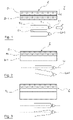
- FIGS. 1 to 3 are diagrammatical representations of a ship towing operating streamers, and zones of coverage generated by the passage of the ship;
- FIG. 4 is a diagrammatical representation of a ship towing a streamer in a study zone with spatial current variations
- FIGS. 5 to 7 are each a diagrammatical representations of the application of a specific embodiment of a method according to the invention.
- FIG. 8 illustrates a decision-making graph for navigating a ship, for the departure of the ship in a study zone in function of the current
- FIGS. 9 and 10 are diagrammatical representations of a ship towing streamers close to a barge, respectively in the absence and in the presence of a transversal current;
- FIG. 11 is a graph of in-situ measurements and projections in time of a current
- FIG. 12 is a diagram representing the main steps of said method.
- streamers can measure over 10 kilometers in length, such that the current at the head and the current at the tail of the streamers may be substantially different (this is especially the case in navigational zones that are not dominated by tidal currents, such as for example in the Gulf of Mexico).
- the variations in current over the length of the streamers influence their form, and failing to take this into account when carrying out a simulation of the shape of the streamer would lead to results that could be far removed from the actual situation.
- the method described does not take into account the spatial variations of the current along the length of the streamers. Furthermore, the method provides several predictions (in total, four current “objects”) and no objective mean that permits the best prediction to be chosen is proposed.
- the purpose of the invention in particular is to overcome the disadvantages of the prior art. More precisely, the purpose of the invention is to propose a method for simulating the positioning of at least one streamer towed in a study zone, including one or several current predictions, which take into account the current variations in time and in space along the length of the streamer. Another purpose of the invention is to provide a method which permits the quality of the current predictions to be improved. Another purpose of the invention is to provide a method which permits the navigator to have several predictions, and to help him to choose which prediction should be applied. Another purpose of the invention is to provide a method which permits the safety of the geophysical data acquisition operations to be improved. Another purpose of the invention is to provide a method which permits the “holes in the coverage” to be reduced in order to limit the number of extra passes of the ship, in a more optimised manner than compared with the technique of the prior art.
- the present invention whose subject matter is a method for simulating the positioning of at least one acoustic linear antenna towed in a study zone, comprising at least one simulation step of at least one future position of at least one point of said acoustic linear antenna(e), at least one step for predicting the temporal and spatial variations of at least one marine current likely to interact with said acoustic linear antenna(e) and at least one step for determining the form of said acoustic linear antenna(e) by the resolution of a hydrodynamic model, characterised in that said prediction step(s) comprise:
- the upstream phase is especially carried out by successive measurements of said current in a discreet number of at least one determined point of said study zone. It may be understood that the measurements made may be mobile within the study zone.
- the future current is determined at certain points of the study zone.
- past measurements of the current are available, associated positions and possibly oceanographic predictions from external bodies (“the predictive data from pre-established bulletins”). Future positions associated to the measurements obtained during the simulation phase are also available.
- the future form of the streamers is determined by digital resolution of a hydrodynamic model.
- the drift map of a point of the streamer in the future is determined, which makes it possible to navigate more safely.
- said temporal projection phase precedes said spatial projection phase, or, alternatively, said spatial projection phase precedes said temporal projection phase.
- said successive measurements are carried out:
- said successive measurements are carried out at a single moving point, said measurements at said moving point being projected to at least one second point of said zone.
- this embodiment has the advantage of only requiring one means of current measurement (a current meter), installed on the ship for example.
- the method preferably comprises either a temporal offset step with respect to a relative reference such as a reference associated to the current meter or a spatial offset step with respect to an absolute reference of said measurements at said moving point.
- the method comprises a selection step, for said projection at said second point, between said spatial offset step and said temporal offset step, by comparing the reference forms, corresponding to actual forms that said acoustic linear antenna(e) have had, with simulated forms obtained by applying said spatial offset step and said temporal offset step.
- said temporal projection phase uses at least one temporal projection technique of said measurements and at least one spatio-temporal interpolation technique of predictive data based on pre-established bulletins.
- said temporal projection phase uses at least one combination technique of said temporal projection phase and of said spatio-temporal interpolation technique, said combination technique preferably comprising a step for determining the differences by comparing of the results of said spatio-temporal interpolation step in the past with currents measured in said upstream phase, said differences being intended to be projected in the time and to be added to the results of said spatio-temporal interpolation step for the future.
- said temporal projection phase comprises a step for choosing a technique or a combination of at least one technique from the group of:
- the combination method comprises a step for weighting the techniques of:
- the principle of the invention lies in the fact that it proposes a method for simulating the positioning of at least one towed streamer, which includes a step for predicting the current carried out so as to determine the current fluctuating at several points, this current being the subject of a spatial projection step so as to define the future currents along the length of the streamers.
- the future form of the streamers is determined by digital resolution of a hydrodynamic model.
- a ship 1 towing two streamers S 1 and S 2 and moving in the direction of an arrow F along a trajectory Li is shown.
- the streamers S 1 and S 2 may correspond to the two streamers located at the lateral ends of a network of a plurality of streamers.
- the ship follows a set of lines that ideally are parallel to one another, the distance between two adjacent lines Li and Li+1 as shown in FIG. 1 are chosen so as to obtain a desired coverage continuity of the measurements of the streamer S 2 when the ship passes on the line Li with the measurement of the streamer S 1 during the following pass of the same ship on the line Li+1.
- the streamers when the ship passes along the line Li, the streamers have covered an elementary zone Zi, and when the ship passes along the line Li+1, the streamers have covered an elementary zone Zi+1.
- the two elementary zones Zi and Zi+1 are continuous. This desired continuity of the coverages is shown in the upper part of FIG. 1 .
- FIG. 2 it may be seen that, in the subsequent pass of the ship on the line Li+1, the part of the streamers that is furthest from the ship is offset transversally towards the line Li. This is typically due to the presence of a current in the direction that is transversal to the lines Li and Li+1 when the ship passes on the line Li+1.
- zone Zi+1 is only partially covered, (which corresponds to a “sub-coverage” situation), and that the zone Zi is partially covered a second time (which corresponds to a “over-coverage” situation).
- FIG. 3 illustrates the case where a variation in current between two consecutive passes causes a divergence in the zones covered by the sets of streamers during these two passes.
- FIG. 9 shows the safe passage of said ship towing the two streamers S 1 and S 2 next to a petrol barge (BP), in the absence of a strong transversal marine current.
- BP petrol barge
- FIG. 10 shows that when this same ship is subjected to a strong transversal current that is poorly or not anticipated, the streamers collide with the barge (BP).
- BP barge
- means for improving the safety and means for reducing the additional passes of the ship to fill in the uncovered zones consist in determining the future form of the streamers in function of the effects of the current(s) that are exerted on them.
- FIG. 12 shows the main steps of said method.
- the form of the streamers (step P 1 of FIG. 12 ) is determined from the digital resolution of the equation of the movements governing an extendable flexible cable subjected to a current which varies along its length.
- This equation known to a person skilled in the art, takes into account the different hydrodynamic parameters of the streamers (coefficient of drag, elasticity, torsion, etc.), as well as those of the tail buoys, the relative speed of the water which varies along the length of the streamers and in time, the air speed on the buoys, etc.
- step P 2 of FIG. 12 the positions of the head of the streamer in time must be known.
- the method according to the invention permits other known positions along the length of the streamers to be integrated. This aspect permits the result to be improved not just when a streamer is free laterally (i.e. a streamer that is only equipped with depth navigation control devices), but also in the case of a streamer that is guided laterally (they are equipped with depth and lateral navigation control devices, such as those described in the patent document published under the number FR-2 870 509).
- the known positions preferably include at least the position of the navigation control devices.
- FIG. 4 provides a diagrammatical illustration of a ship 1 towing a streamer 2 (associated in this case to the tail of a buoy 4 ) with two points 3 for which the relative speed of the water is to be predicted. This figure clearly illustrates the case of a current 5 with spatial variations in the study zone, and in particular along the length of the streamer.
- the current along the length of the streamers must be determined, at the depth of the streamers. The method for determining this current is described below.
- the method according to the invention comprises an upstream phase for using current meter data available for the study zone, these data may be obtained by measurements using one or several current meters, and/or taken from pre-established bulletins (such as oceanographic predictions provided by specialised organisations). These available data are then projected into the future, at different points along the length of the streamers.
- This temporal projection phase of the current at a point (fixed or moving) will be detailed below in the description.
- a ship 1 tows a linear acoustic antenna 2 and the current is measured at one or several points 3 .
- a discreet number of points 3 (fixed or moving) is determined, this number is sufficient to define a perimeter containing at least the streamer 2 whose future form is to be defined. For these points, the current and the associated position (step P 3 of FIG. 12 ) are obtained if possible during an upstream phase.
- the current along the length of the streamer at an instant t is obtained by interpolation on two dimensions at the instant t of the currents at the points 3 in a discreet number of points (between the points 3 ) along the length of the streamer (supposed to be aligned on the route of the ship), according to step PS 3 of FIG. 12 ).
- a discreet number of points 3 are determined, in this case at least two, one being in front of and the other behind the streamer 2 .
- the current and the associated position are obtained if possible during an upstream phase.
- the current along the length of the streamer 2 at an instant t is obtained by interpolation on one dimension at the instant t of the currents at the points 3 in a discreet number of points (between the points 3 ) along the length of the streamer (supposedly aligned on the route of the ship), according to step PS 3 of FIG. 12 .
- the current and its associated position are identified using a current meter carried by a point close to the streamer.
- the proximity of the streamer may be especially the ship towing it, another ship, or even a point of the streamer itself.
- two possibilities may be envisaged:
- This second point may be especially the tail of the streamer (where the streamer is supposed to follow the route).
- the in-situ positioning data of the streamers are used.
- the form of the streamers is calculated according to two distinct approaches, one according to which the same current is considered along the length of the streamers, and the other according to which a temporal offset of the current at the level of the ship is made.
- the quadratic error for the curves of the different angles used to model the streamers may be chosen as the standard.
- the temporal projection phase of the current at one point is detailed below.
- the “prolonged measurement” predictions are obtained as follows: for each current meter, after collecting or bringing back the data from the depth of the streamers, the series of currentmeter measurements is prolonged.
- the prolongation is carried out for each current component for example the strength and the direction, or even the zone and meridian components.
- the “oceanographic predictions” are obtained as follows: for each oceanographic prediction, as the future positions of the point for which the current is to be predicted are known (by simulation), a four dimensional interpolation (3 spatial dimensions and a temporal dimension) is used to determine the predictions for this point (step PT 2 of FIG. 12 ).
- the “combined” predictions are obtained as follows. A reminder is first made that, in the same way as meteorological predictions, the oceanographic predictions have local variations. By combining these oceanographic predictions with the current meter data collected, a prediction that makes optimal use of all the data may be obtained. For this purpose, the difference between the oceanographic prediction interpolated at the past positions of the point and the current meter data at this point is calculated at a determined point (the difference is evaluated for each current component). These calculated differences are then prolonged and are then subsequently added to the oceanographic predictions interpolated at the future positions of the point.
- the method according to the invention thus allows to obtain, for each point for which the current is to be determined, N “prolonged measurement” predictions, M “oceanographic” predictions and N*M “combined” predictions.
- the method according to the invention also permits one of these predictions made in steps PT 1 , PT 2 , PT 3 to be chosen, and if possible the best one (step PT 4 of FIG. 12 ). This choice is made as follows.
- the method consists in defining the situation a few hours earlier.
- N+M+N*M predictions are calculated up until the present instant: N+M+N*M predictions of the “near past” are thus made.
- the method thus consists in comparing the different predictions: it is the calculation of a standard of the difference between the in-situ current and the predicted current which will allow this comparison to be made.
- the i-th prediction P i (1 ⁇ i ⁇ N+M+N*M) has the standard ⁇ i .
- the chosen standard may be the Euclidian 2D standard, the quadratic error for transversal currents, or other standards known from the prior art.
- FIG. 11 places in parallel different curves among which:
- the best “near past” prediction is that which has the smallest standard.
- the predictions may then be weighted.
- the weight p i is associated to the prediction P i with
- p i ⁇ 1 ⁇ j ⁇ N + M + N * M j ⁇ i ⁇ ⁇ ⁇ j ⁇ 1 ⁇ k ⁇ N + M + N * M ⁇ ⁇ 1 ⁇ j ⁇ N + M + N * M j ⁇ k ⁇ ⁇ ⁇ j .
- the best “near past” prediction is that which has the largest weighting.
- a presentation to navigators of this “near past” prediction and the associated weightings offers the navigators on assistance for the decision making concerning the best prediction to adopt.
- Using objectively calculated weighting permits the navigator to be advised or orientated when making the final choice.
- step PT 5 of FIG. 12 Another prediction may also be made (step PT 5 of FIG. 12 ) which is nothing else but the weighting of the N+M+N*M weighted predictions of the weights corresponding to the N+M+N*M predictions of the “near past”.
- This prediction has the advantage of being automatic and is naturally close to the best type of predictions.
- the future current on the ship is determined as previously, the method further comprising a step for determining the current along the entire length of the streamer as follows.
- Calculating a transversal drift in the future allows the navigator to identify in the future the width of the network of streamers, and to define the route to take to navigate with the most safety.
- the current or the form of the future line is predicted and then compared by calculating a standard of the difference between the prediction made and the measurements made for the adjacent line.
- the optimum choice is thus that for which the line, the time and the speed correspond to the smallest standard.
- These different parameters may be presented to the navigator on a graph such as that illustrated in FIG. 8 . Carrying out such an operation thus permits the navigator to choose the scenario which reduces as far as possible the “holes in the coverage” between different possible scenarios in the near future.
Landscapes
- Life Sciences & Earth Sciences (AREA)
- Physics & Mathematics (AREA)
- Engineering & Computer Science (AREA)
- Remote Sensing (AREA)
- Acoustics & Sound (AREA)
- Oceanography (AREA)
- Environmental & Geological Engineering (AREA)
- Geology (AREA)
- General Life Sciences & Earth Sciences (AREA)
- General Physics & Mathematics (AREA)
- Geophysics (AREA)
- Radar, Positioning & Navigation (AREA)
- Navigation (AREA)
- Measurement Of Velocity Or Position Using Acoustic Or Ultrasonic Waves (AREA)
Applications Claiming Priority (3)
| Application Number | Priority Date | Filing Date | Title |
|---|---|---|---|
| FR0707093A FR2922321B1 (fr) | 2007-10-10 | 2007-10-10 | Methode de simulation de positionnement d'au moins un streamer comprenant une etape de prediction d'un courant en au moins deux points distincts du streamer |
| FR07/07093 | 2007-10-10 | ||
| FR0707093 | 2007-10-10 |
Publications (2)
| Publication Number | Publication Date |
|---|---|
| US20090097355A1 US20090097355A1 (en) | 2009-04-16 |
| US9001616B2 true US9001616B2 (en) | 2015-04-07 |
Family
ID=39495549
Family Applications (1)
| Application Number | Title | Priority Date | Filing Date |
|---|---|---|---|
| US12/245,881 Active 2032-11-07 US9001616B2 (en) | 2007-10-10 | 2008-10-06 | Method for simulating the positioning of at least one streamer comprising a step for predicting the current on at least two distinct points of the streamer |
Country Status (6)
| Country | Link |
|---|---|
| US (1) | US9001616B2 (fr) |
| CN (1) | CN101435877B (fr) |
| CA (1) | CA2640301C (fr) |
| FR (1) | FR2922321B1 (fr) |
| GB (1) | GB2453635B (fr) |
| NO (1) | NO341669B1 (fr) |
Cited By (1)
| Publication number | Priority date | Publication date | Assignee | Title |
|---|---|---|---|---|
| US11554838B1 (en) * | 2020-05-11 | 2023-01-17 | The United States Of America, As Represented By The Secretary Of The Navy | Maneuvering and control simulator for underwater vehicles |
Families Citing this family (6)
| Publication number | Priority date | Publication date | Assignee | Title |
|---|---|---|---|---|
| FR2961317B1 (fr) * | 2010-06-10 | 2014-01-17 | Kietta | Procede de prospection sismique en milieu aquatique |
| EP2607921B1 (fr) * | 2011-12-19 | 2020-05-20 | Sercel | Procédé et dispositif pour gérer les performances acoustiques d'un réseau de n'uds acoustique disposés le long d'antennes linéaires acoustiques remorquées |
| EP2690461B1 (fr) * | 2012-07-26 | 2017-03-01 | Sercel | Procédé pour estimer la vitesse de l'eau d'un noeud acoustique |
| US11222304B2 (en) * | 2018-04-10 | 2022-01-11 | Florida A&M University | Automated scheduling and vessel navigation system for container shipping |
| EP3657127B1 (fr) * | 2018-11-21 | 2022-08-03 | Sercel | Procédé de planification d'une trajectoire en présence de courant d'eau |
| CN116449428A (zh) * | 2023-04-23 | 2023-07-18 | 中海石油(中国)有限公司 | 一种海上拖缆地震采集装置和方法 |
Citations (5)
| Publication number | Priority date | Publication date | Assignee | Title |
|---|---|---|---|---|
| FR2807842A1 (fr) | 2000-04-13 | 2001-10-19 | Cgg Marine | Methode de simulation de positionnement de steamer, et d'aide a la navigation |
| US20060256653A1 (en) * | 2005-05-05 | 2006-11-16 | Rune Toennessen | Forward looking systems and methods for positioning marine seismic equipment |
| WO2007006785A2 (fr) | 2005-07-12 | 2007-01-18 | Westerngeco Seismic Holdings Limited | Procedes et appareil pour l'acquisition de donnees sismiques marines |
| GB2432911A (en) | 2005-12-02 | 2007-06-06 | Westerngeco Seismic Holdings | Using measurements of tension and shape of seismic streamers to predict ocean current |
| US20090141587A1 (en) * | 2004-02-23 | 2009-06-04 | Westerngeco, L.L.C. | Marine seismic survey method and system |
Family Cites Families (2)
| Publication number | Priority date | Publication date | Assignee | Title |
|---|---|---|---|---|
| FR2808842B1 (fr) * | 2000-05-15 | 2002-07-26 | Bitron France | Dispositif de pompage d'un liquide contenu dans un reservoir |
| JP4290646B2 (ja) * | 2002-05-23 | 2009-07-08 | インプット/アウトプット インコーポレイテッド | Gps方式の水中ケーブル位置決めシステム |
-
2007
- 2007-10-10 FR FR0707093A patent/FR2922321B1/fr active Active
-
2008
- 2008-09-26 GB GB0817681.0A patent/GB2453635B/en not_active Expired - Fee Related
- 2008-10-03 CA CA2640301A patent/CA2640301C/fr not_active Expired - Fee Related
- 2008-10-06 US US12/245,881 patent/US9001616B2/en active Active
- 2008-10-09 NO NO20084225A patent/NO341669B1/no not_active IP Right Cessation
- 2008-10-10 CN CN2008101698833A patent/CN101435877B/zh not_active Expired - Fee Related
Patent Citations (6)
| Publication number | Priority date | Publication date | Assignee | Title |
|---|---|---|---|---|
| FR2807842A1 (fr) | 2000-04-13 | 2001-10-19 | Cgg Marine | Methode de simulation de positionnement de steamer, et d'aide a la navigation |
| US6618321B2 (en) * | 2000-04-13 | 2003-09-09 | Cgg Marine | Method for simulating streamer positioning, and for navigation aid |
| US20090141587A1 (en) * | 2004-02-23 | 2009-06-04 | Westerngeco, L.L.C. | Marine seismic survey method and system |
| US20060256653A1 (en) * | 2005-05-05 | 2006-11-16 | Rune Toennessen | Forward looking systems and methods for positioning marine seismic equipment |
| WO2007006785A2 (fr) | 2005-07-12 | 2007-01-18 | Westerngeco Seismic Holdings Limited | Procedes et appareil pour l'acquisition de donnees sismiques marines |
| GB2432911A (en) | 2005-12-02 | 2007-06-06 | Westerngeco Seismic Holdings | Using measurements of tension and shape of seismic streamers to predict ocean current |
Non-Patent Citations (1)
| Title |
|---|
| French Search Report, dated Jun. 26, 2008, 2 pages. |
Cited By (1)
| Publication number | Priority date | Publication date | Assignee | Title |
|---|---|---|---|---|
| US11554838B1 (en) * | 2020-05-11 | 2023-01-17 | The United States Of America, As Represented By The Secretary Of The Navy | Maneuvering and control simulator for underwater vehicles |
Also Published As
| Publication number | Publication date |
|---|---|
| CN101435877B (zh) | 2013-03-20 |
| FR2922321B1 (fr) | 2009-12-11 |
| CA2640301A1 (fr) | 2009-04-10 |
| NO20084225L (no) | 2009-04-14 |
| GB2453635B (en) | 2012-09-12 |
| CA2640301C (fr) | 2015-02-17 |
| GB2453635A (en) | 2009-04-15 |
| GB0817681D0 (en) | 2008-11-05 |
| CN101435877A (zh) | 2009-05-20 |
| US20090097355A1 (en) | 2009-04-16 |
| NO341669B1 (no) | 2017-12-18 |
| FR2922321A1 (fr) | 2009-04-17 |
Similar Documents
| Publication | Publication Date | Title |
|---|---|---|
| EP3931527B1 (fr) | Système et procédé de prédiction d'onde | |
| US9001616B2 (en) | Method for simulating the positioning of at least one streamer comprising a step for predicting the current on at least two distinct points of the streamer | |
| Turnbull et al. | Operational iceberg drift forecasting in Northwest Greenland | |
| Poulain et al. | MedArgo: a drifting profiler program in the Mediterranean Sea | |
| Zhou et al. | Mapping the underside of an iceberg with a modified underwater glider | |
| Alford et al. | A real-time system for forecasting extreme waves and vessel motions | |
| EP3078991A1 (fr) | Procédé servant à corriger des effets de gonflement et mis-tie dans des données sismiques à haute résolution à l'aide des données d'échosondeur multifaisceau | |
| CN107430004B (zh) | 用于计算至少一艘船的水面速的方法和用于推导在该船的路径上每个点处的漂移向量的方法 | |
| Mayer et al. | High-resolution mapping of mines and ripples at the Martha's Vineyard Coastal Observatory | |
| Walker et al. | Underwater sound speed profile estimation from vessel traffic recordings and multi-view neural networks | |
| Mao et al. | A comparison of two wave models and their influence on fatigue damage in ship structures | |
| Takahashi et al. | Buoy platform development for observation of tsunami and crustal deformation | |
| Turnbull et al. | Iceberg Drift Simulations Using Inferred, Measured, and Ocean Model Currents | |
| Montazeri | Estimation of waves and ship responses using onboard measurements | |
| Hlophe | Efficient real-time deterministic wave prediction for marine renewable energy | |
| Reichert et al. | X-Band radar derived sea surface elevation maps as input to ship motion forecasting | |
| Olsson et al. | A New Method for As-built Burial Risk Assessment for Subsea Cables | |
| Wrenger et al. | Waves in the great pacific garbage patch: cross validation of three measurement techniques and two WW3 models | |
| Riordan et al. | Ship anti-grounding with a maritime autonomous surface ship and digital twin of Port of Hamburg | |
| Traykovski et al. | Rapid Response Surveys of Mobility, Burial and Re-Exposure of Underwater Munitions in Energetic Surf-Zone Environments and Object Monitoring Technology Development | |
| KR102718968B1 (ko) | 스마트 선박용 서비스 제공 플랫폼 및 방법 | |
| Radhakrishnan et al. | Retrieval of Ocean Wave Spectra From X-Band Marine Radar Images Using Inversion Schemes Based on Auto-Spectral Analysis | |
| Chao et al. | Specification of hurricane wind fields for ocean wave prediction | |
| Fu et al. | Committee No I. 1: Environment: Environment | |
| De Girolamo et al. | Wave characteristics estimation by GPS receivers installed on a sailboat travelling off-shore |
Legal Events
| Date | Code | Title | Description |
|---|---|---|---|
| AS | Assignment |
Owner name: SERCEL, FRANCE Free format text: ASSIGNMENT OF ASSIGNORS INTEREST;ASSIGNORS:CLEMENT, VISSEAUX;VERONIQUE, L'HER;REEL/FRAME:022118/0466 Effective date: 20081016 |
|
| STCF | Information on status: patent grant |
Free format text: PATENTED CASE |
|
| MAFP | Maintenance fee payment |
Free format text: PAYMENT OF MAINTENANCE FEE, 4TH YEAR, LARGE ENTITY (ORIGINAL EVENT CODE: M1551); ENTITY STATUS OF PATENT OWNER: LARGE ENTITY Year of fee payment: 4 |
|
| MAFP | Maintenance fee payment |
Free format text: PAYMENT OF MAINTENANCE FEE, 8TH YEAR, LARGE ENTITY (ORIGINAL EVENT CODE: M1552); ENTITY STATUS OF PATENT OWNER: LARGE ENTITY Year of fee payment: 8 |