WO2009128496A1 - Dispositif de navigation - Google Patents
Dispositif de navigation Download PDFInfo
- Publication number
- WO2009128496A1 WO2009128496A1 PCT/JP2009/057643 JP2009057643W WO2009128496A1 WO 2009128496 A1 WO2009128496 A1 WO 2009128496A1 JP 2009057643 W JP2009057643 W JP 2009057643W WO 2009128496 A1 WO2009128496 A1 WO 2009128496A1
- Authority
- WO
- WIPO (PCT)
- Prior art keywords
- point
- display
- display position
- displayed
- unit
- Prior art date
- Legal status (The legal status is an assumption and is not a legal conclusion. Google has not performed a legal analysis and makes no representation as to the accuracy of the status listed.)
- Ceased
Links
Images








Classifications
-
- G—PHYSICS
- G01—MEASURING; TESTING
- G01C—MEASURING DISTANCES, LEVELS OR BEARINGS; SURVEYING; NAVIGATION; GYROSCOPIC INSTRUMENTS; PHOTOGRAMMETRY OR VIDEOGRAMMETRY
- G01C21/00—Navigation; Navigational instruments not provided for in groups G01C1/00 - G01C19/00
- G01C21/26—Navigation; Navigational instruments not provided for in groups G01C1/00 - G01C19/00 specially adapted for navigation in a road network
- G01C21/34—Route searching; Route guidance
- G01C21/36—Input/output arrangements for on-board computers
-
- G—PHYSICS
- G06—COMPUTING OR CALCULATING; COUNTING
- G06F—ELECTRIC DIGITAL DATA PROCESSING
- G06F3/00—Input arrangements for transferring data to be processed into a form capable of being handled by the computer; Output arrangements for transferring data from processing unit to output unit, e.g. interface arrangements
- G06F3/01—Input arrangements or combined input and output arrangements for interaction between user and computer
- G06F3/048—Interaction techniques based on graphical user interfaces [GUI]
- G06F3/0487—Interaction techniques based on graphical user interfaces [GUI] using specific features provided by the input device, e.g. functions controlled by the rotation of a mouse with dual sensing arrangements, or of the nature of the input device, e.g. tap gestures based on pressure sensed by a digitiser
- G06F3/0488—Interaction techniques based on graphical user interfaces [GUI] using specific features provided by the input device, e.g. functions controlled by the rotation of a mouse with dual sensing arrangements, or of the nature of the input device, e.g. tap gestures based on pressure sensed by a digitiser using a touch-screen or digitiser, e.g. input of commands through traced gestures
-
- G—PHYSICS
- G09—EDUCATION; CRYPTOGRAPHY; DISPLAY; ADVERTISING; SEALS
- G09B—EDUCATIONAL OR DEMONSTRATION APPLIANCES; APPLIANCES FOR TEACHING, OR COMMUNICATING WITH, THE BLIND, DEAF OR MUTE; MODELS; PLANETARIA; GLOBES; MAPS; DIAGRAMS
- G09B29/00—Maps; Plans; Charts; Diagrams, e.g. route diagram
- G09B29/10—Map spot or coordinate position indicators; Map reading aids
- G09B29/106—Map spot or coordinate position indicators; Map reading aids using electronic means
Definitions
- a pedestrian navigation system using a mobile terminal device such as a mobile phone is also provided.
- This navigation system is a communication-type navigation system composed of a mobile terminal device and a route search server.
- a device that is provided with a touch panel on the display unit so that various operations can be performed so that the operation can be performed without disturbing the driving operation.
- a desired selection item is selected on the menu screen displayed on the display unit to perform function selection or switching processing, or a desired point on the map image displayed on the display unit. You can set destinations and waypoints.
- Patent Document 1 discloses a vehicular route guidance device that designates a desired point by a touch operation on a map image displayed on a display unit and sets a destination or a waypoint.
- This vehicle route guidance device displays the operation keys “Register” and “Destination” on the map display screen based on the place name index, and when the “Register” key is touched, A point registration process is performed, and when the “destination” key is touched, the destination can be set on the map display at that time.
- Patent Document 3 discloses a navigation device capable of generating a mark by an intuitive operation.
- This navigation device displays control buttons such as a mark setting button, a destination setting button, a waypoint setting button, and an erasing button, which are associated with a specific process, together with a map on a display unit. Then, when a specific mark setting button and arbitrary coordinates on the map are specified by a drag operation on the touch panel, the mark generation processing unit generates a mark object at a position on the map corresponding to the specified coordinates. By displaying as above, a desired point can be set.
- the point setting includes several setting processing items such as setting of a departure point, setting of a destination, setting of a waypoint, and registration of a point.
- setting processing items such as setting of a departure point, setting of a destination, setting of a waypoint, and registration of a point.
- Patent Documents 1 to 3 the techniques disclosed in Patent Documents 1 to 3 described above are used. After displaying the selection item buttons for making those selections and performing item selection, after specifying the desired point on the map image using the touch panel or conversely, after specifying the desired point, The point setting process was performed by operating the selection item button.
- An object of the present invention is to solve the above-mentioned problems, and when setting a point by specifying a desired point on a map displayed on a display unit, a point setting menu image is displayed in the vicinity of the specified point. Accordingly, an object of the present invention is to provide a navigation device in which the visibility of the positional relationship between the two is improved and the operability is improved.
- the invention according to claim 1 of the present application is directed to an input unit that specifies a point on a map displayed on a display unit; and a point position that specifies a point specified by the input unit; A detection unit; a menu display position determination unit for determining a display position of a menu image for selecting an item for setting a point specified by the point position detection unit; and a point setting mark indicating the designated point; A menu display position determining unit that detects a display position of the spot setting mark and displays the menu image according to the display position of the spot setting mark. The position is determined.
- the point setting menu image is displayed in consideration of the display position of the desired point to be set, and the visibility is improved, so that the operability is improved.
- the menu image is displayed as a balloon from the point setting mark.
- the positional relationship between the spot setting mark and the spot setting menu image is emphasized by the balloon, and the visibility is improved, so that the operability is improved.
- the display area of the display unit is divided into a predetermined number of areas, and the menu display position determination unit includes the point setting mark. Is detected, and it is determined that the menu image is arranged close to the point setting mark on the side of the vertical direction or the horizontal direction facing the detected region.
- the point setting mark, the point setting mark, and the menu image of the point setting are displayed at the desired position to be set regardless of the display area on the display screen where the desired position to be set is. Since the images are displayed close to each other and the visibility is improved, the operability is improved.
- the menu display position determination unit detects a display position of the spot setting mark and intersects at the detected display position of the spot setting mark.
- the display screen is divided by a plurality of straight lines, and the menu image display position is determined in consideration of the area of each area of the divided display screen.
- the display screen is divided into a plurality of radial areas with the display position of the point setting mark as the center of division, and the menu image is displayed in consideration of the area of each divided area. Since the visibility of the positional relationship between the point setting mark and the menu image is improved, the operability is improved.
- the menu display position determining means sets a region having the largest area as the menu image display position among the divided regions of the display screen.
- the menu image is displayed in the area having the largest area among the areas divided radially with the point setting mark as the center of the division, and the display screen has no sense of congestion and gives a sense of uniformity. Since the visibility is improved by arranging it, the operability is improved.
- the menu image of the point setting is displayed in consideration of the display position of the desired point to be set, and the visibility of the positional relationship between the point setting mark and the menu image is improved.
- the operability of point setting can be improved.
- the total number 4 of upper and lower 2 and left and right 2 is shown as the number of divisions of the display screen, but the number of divisions of the screen is not limited to 4, and the aspect ratio and screen Depending on the size, the number can be any number of 3 or more vertically and 3 or more horizontally. For example, the number of divisions may be 18 areas divided up and down 3 and 6 right and left.
- the high-definition broadcast has an aspect ratio of 9 to 16 in the vertical direction, for example, when the display unit is a combined type capable of receiving a high-definition television broadcast, the number of divided areas increases, Since it is close to a square, it is possible to display according to detailed conditions, giving a sense of uniformity and further improving visibility.
- FIG. 1 is a block diagram showing a configuration of an in-vehicle navigation device according to an embodiment of the present invention.
- the navigation device 1 may be a navigation device used for in-vehicle use by being placed on a dashboard of a vehicle such as an automobile, and is a type that can be removed from the vehicle and carried by the user. It may be a thing. In the following description, these are collectively referred to as the navigation device 1.
- the navigation device 1 includes a control unit 10, a current position detection unit 11, a map storage unit 12, an input unit 13, a display unit 14, a route search unit 15, a point position detection unit 16, a menu display position determination unit 17, and a mark display unit 18.
- a display control unit 19 including
- the control unit 10 includes a processor including a CPU, a RAM, a ROM, and the like, and controls the operation of each unit of the navigation device 1 according to a control program recorded in the RAM and the ROM.
- the current position detection unit 11 includes, for example, a GPS receiver, receives radio waves including time information from a plurality of GPS satellites orbiting the earth, recognizes the current position based on the radio wave, and detects current position information. Create
- the current position detection unit 11 may be used in combination with a self-contained navigation unit including a steering angle sensor, an acceleration sensor, a distance sensor, a direction sensor, and the like.
- the current position is calculated by detecting the travel distance and travel direction of the vehicle and adding these values to the reference position.
- the current position detection method by the self-contained navigation unit is effective in a tunnel where GPS radio waves cannot be received or in a high-rise building town where errors due to radio wave scattering are likely to occur when combined with the GPS reception method.
- the map storage unit 12 stores road data including road node data and road link data in which nodes such as intersections and branch points of each road are nodes and routes connecting the respective nodes are links.
- the road node data includes road node numbers, position coordinates, the number of connection links, intersection names, and the like.
- the road link data includes the number of the road node as the starting point and the end point, the road type, the link length (link cost), the required time, the number of lanes, the road width, and the like. Further, data such as bridges, tunnels, railroad crossings, and toll gates are added to the road link data as link attributes.
- the road type is information including classification of highways and toll roads, classification of national roads, prefectural roads, and the like.
- road data For highways, road data includes location information of specific areas such as parking areas and service areas provided on the respective highways, entry routes to the specific areas, and escape routes from the specific areas. Information is included.
- the road data includes attribute information such as road types such as highways, national roads, prefectural roads, municipal roads, road widths, and the number of lanes, and is stored as map data according to the traveling direction of up and down.
- the map data stored in the map storage unit 12 can be updated by downloading the latest map data from the server by connecting to the server via the Internet using a communication unit (not shown).
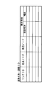
- FIG. 2 is a diagram showing an example of the data structure of road data included in the map data.
- the road data stores, for each road (road name or road ID), the link ID of each road link, the start point node, the end point node, and road attribute information.
- the attribute information includes information such as the type of road such as an expressway, a national road, a prefectural road, and the width of the road.
- the input unit 13 is composed of various keys, switches, and the like, and performs input operations on the navigation device 1. Moreover, it can also be set as the input unit 13 by providing a touch panel in the display unit 14 mentioned later, and input operation can also be performed using this touch panel.
- the display unit 14 displays a map image and a guide route on the map image so as to be distinguishable from other roads at the time of route guidance, and includes, for example, a liquid crystal display.
- the route search unit 15 searches for the optimum route from the departure point to the destination by referring to the road data stored in the map storage unit 12 when the departure point or destination is designated by the user via the input unit 13. Then, guide route data is created.
- the search for the optimum route is performed by various links and nodes such as Dijkstra's method from the road node corresponding to the current position or the starting point specified by the user to the road node corresponding to the destination specified by the user. Search by method, accumulate link length (link cost), required time, etc., for example, use the route with the shortest total link length or total required time as the guide route, and use the road nodes and links belonging to the route as the guide route Provide as data.
- the searched route is displayed on the display unit 14 together with the map image.
- a current position mark indicating the current position of the vehicle is displayed superimposed on the map image.
- the map image is scrolled as the vehicle travels, and for example, the current position is displayed at the center of the display screen.
- the current position detection unit 11 since the position information detected by the current position detection unit 11 includes an error, the current position may be calculated with a deviation from the road. In such a case, map matching for correcting the current position on the road is performed by a matching processing unit (not shown).
- the point position detection unit 16 compares the point on the touch panel specified by the user with road data. To identify the specified point.
- a desired position is specified on the map image, and a destination or waypoint is set, the point input mode is selected using the input unit 13 and set.
- a map image including the point is displayed.
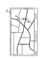
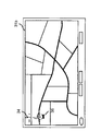
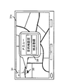
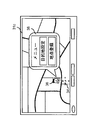
- 3A, 3B, and 3C are screen transition diagrams showing the concept of this procedure.
- the display image 31a shown in FIG. 3A is changed to the display image shown in FIG. 3B.
- the screen changes to 31b, and the cursor 34 is displayed at the position of the desired point 32, and the point setting mark 36 is displayed near the cursor 34.
- the display screen changes to 31c shown in FIG. 3C, and a point setting menu image 38 is displayed in the vicinity of the point setting mark 36.
- the spot setting menu image 38 is displayed by a balloon from the spot setting mark 36.
- the position pointed to by the point setting mark 36 is set as the point.
- the position indicated by the point setting mark 36 is the display position of the cursor 34.
- the position indicated by the point setting mark 36 may not always correctly indicate the desired position to be set. In this case, the user moves the cursor 34 or the point setting mark 36 to the correct desired position on the displayed map image by enlarging the map.
- the position of the moving destination becomes a position where the point is to be set, so that when the user performs a point setting operation by touching the point setting mark 36, in the vicinity of the point setting mark 36 displayed at the moving destination,
- a point setting menu image 38 is displayed and one of selection items such as destination setting and point registration is selected, the position pointed to by the point setting mark 36 is set as a target point of the operation.
- the point setting mark 36 is displayed at a desired position to be set, and the point setting menu image 38 displayed in a balloon from the point setting mark 36 is displayed at the same time. It is easy to use and the operability of setting the location is improved.
- the point setting mark 36 is not displayed at a fixed position such as the center of the displayed map image, but is displayed near the position where the user wants to set the point.
- Which display area is best to display in a balloon differs depending on the display position of the point to be set on the screen. Therefore, in the present invention, the display position of the menu image 38 is controlled according to the display position of the point setting mark 36.
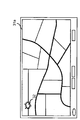
- FIG. 4 is a diagram showing the concept of this display position control.
- the display screen is divided into four areas, the first quadrant, the second quadrant, the third quadrant, and the fourth quadrant clockwise from the upper left by two straight lines orthogonal to the center of the screen as shown in FIG. 4A. Then, the spot position detection unit 16 detects in which quadrant of the display screen the position indicated by the spot setting mark 36, that is, the position where the cursor 34 is displayed.
- the point position detection unit 16 compares the point on the touch panel specified by the user with the road data when the user operates the touch panel to specify a desired point on the map image displayed on the display unit 14. Then, it is determined that the position indicated by the point setting mark 36, that is, the cursor 34 is displayed at the specified point.
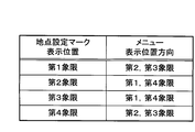
- the menu display position determination unit 18 determines the display position for displaying the balloon display of the point setting menu image 38 for the point setting mark in accordance with the quadrant where the point setting mark 36 is displayed. For example, in the example shown in FIG. 3C, since the point setting mark 36 is displayed in the second quadrant, the menu image 38 is arranged in the direction of the first quadrant or the fourth quadrant with respect to the point setting mark. Is displayed in a speech bubble. In this case, the arrangement direction of the menu image with respect to the point setting mark is a problem, and the arrangement position of the menu image itself is not particularly problematic no matter what quadrant it is.
- the determination of the arrangement direction is determined according to the data table of FIG. 4B.
- the display position directions of the menu image 38 are the second quadrant and the third quadrant which are the right and lower directions.
- the display position directions of the menu image 38 are the first quadrant and the fourth quadrant which are the lower and left directions.
- the point setting mark may be displayed as shown in FIG.
- the point setting mark 36 is displayed in a model in which the periphery of a mark (finger shape) similar to the point setting mark 36 shown in FIG. 3 is surrounded by a frame. According to this display type, even if the finger-shaped portion is not correctly touched, it can be determined that the point setting mark has been operated only by touching anywhere in the frame.
- the display position of the menu image 38 is not limited as long as it can be displayed in another display area of the display screen relative to the position where the spot setting mark 36 is displayed based on the size of the image. It does not have to be. What is necessary is just to determine so that both images can be displayed in a display area by relatively judging the positional relationship of two images in a display area.
- the display screen is divided into four quadrants divided in advance at the screen center.
- the present invention is not necessarily limited to the above-described embodiment in which the division position is fixed.
- the display screen is divided into four by an upper and lower dividing line and a left and right dividing line that are orthogonal to each other at the display position of the point setting mark.
- Each area divided in such a manner generally has a large or small area. Therefore, considering the area of each area of the divided display screen, for example, the area with the largest area is displayed as a menu image. The position may be determined.
- the screen is divided into four rectangles using straight lines extending vertically and horizontally with respect to the display screen, but the screen division is not limited to rectangles.
- the screen may be divided using a plurality of radially intersecting straight lines.
- the division is performed in a ring shape, and the menu image display position can be arranged radially from the division center in consideration of the distance from the division center to the display position of the point setting mark. Is further improved.
- FIG. 8 is a flowchart showing an operation procedure of spot setting in the navigation device 1.
- Step S101 When displaying a map image on the display unit 14, specifying a desired position (point) on the map image, and setting a destination or waypoint, the user selects a point input mode via the input unit 13. (Step S101), a map image including the point to be set is displayed. In order to display a map image including a desired point, the map is scrolled by touching the touch panel with a finger to move the cursor, or the map is scrolled using a joystick provided on the remote control.
- step S102 When a point is specified in step S102, the point position detection unit 16 specifies the specified point, and the display control unit 19 places the cursor on the map image corresponding to the point specified by the point position detection unit 16. Display, and proceed to step S103.
- step S103 the mark display unit 18 of the display control unit 19 indicates that the position is set in the vicinity of the cursor based on the cursor position specified by the point position detection unit 16 and displayed by the display control unit 19.
- a point setting mark 36 (see FIG. 3) is displayed.
- step S104 it is determined whether or not the displayed point setting mark 36 has been touched. If the location setting mark 36 is touched, the position pointed to by the location setting mark 36, that is, the cursor position is designated as the location, so the process proceeds to step S105, where the menu display position determining unit 17 determines the location mark 36. The display position of the menu image is determined based on the display position, and the display control unit 19 displays the point setting menu image 38 (see FIG. 3) at the determined position.
- step S106 it is determined whether or not the selected item of the displayed menu image 38 has been operated. If there is no operation, step S106 is repeated, and if it is determined that there has been an item selection operation, the process proceeds to step S107, the position pointed to by the point setting mark 36 is set according to the selected point setting item, and the process ends. .
- the point on the map image is specified by a point on the touch panel specified by the user when the user operates the touch panel and designates a desired point on the map image displayed on the display unit 14 as described above. Is selected from the road data.
- step S104 the position pointed to by the spot setting mark 36 is not the spot setting position desired by the user. It is determined whether or not.
- the point changing operation is performed by operating a desired point on the map image displayed by moving a finger or a cursor.
- step S108 When the point change touch operation is detected in step S108, the process returns to step S103, the point setting mark 36 is displayed in the vicinity thereof, and the processes after step S104 are repeated. If no more point change touch operation is detected, the point setting process is terminated.
- the location setting mark 36 and the location setting menu image 38 displayed in a balloon from the location setting mark are displayed at the desired location where the location is desired to be set. Is improved, usability is improved, and the operability of point setting is improved.
- the navigation device of the present invention visually recognizes a positional relationship by displaying a point setting menu image in the vicinity of a designated point when a desired point is designated on the map displayed on the display unit and the point is set. This is industrially useful because of improved operability and improved operability.
- Navigation device 10 Control unit 11: Current position detection unit 12: Map storage unit 13: Input unit 14: Display unit 15: Route search unit 16: Point position detection unit 17: Menu display position determination unit 18: Mark display unit 19: Display control unit
Landscapes
- Engineering & Computer Science (AREA)
- Theoretical Computer Science (AREA)
- Physics & Mathematics (AREA)
- Radar, Positioning & Navigation (AREA)
- Remote Sensing (AREA)
- General Physics & Mathematics (AREA)
- General Engineering & Computer Science (AREA)
- Business, Economics & Management (AREA)
- Mathematical Physics (AREA)
- Educational Administration (AREA)
- Educational Technology (AREA)
- Automation & Control Theory (AREA)
- Human Computer Interaction (AREA)
- Navigation (AREA)
- Instructional Devices (AREA)
- User Interface Of Digital Computer (AREA)
- Traffic Control Systems (AREA)
Abstract
Priority Applications (3)
| Application Number | Priority Date | Filing Date | Title |
|---|---|---|---|
| KR1020137005092A KR20130045370A (ko) | 2008-04-17 | 2009-04-16 | 내비게이션 장치 |
| CN200980113056.5A CN102007374B (zh) | 2008-04-17 | 2009-04-16 | 导航装置 |
| US12/937,619 US8442757B2 (en) | 2008-04-17 | 2009-04-16 | Navigation device |
Applications Claiming Priority (2)
| Application Number | Priority Date | Filing Date | Title |
|---|---|---|---|
| JP2008107578A JP5428189B2 (ja) | 2008-04-17 | 2008-04-17 | ナビゲーション装置 |
| JP2008-107578 | 2008-04-17 |
Publications (1)
| Publication Number | Publication Date |
|---|---|
| WO2009128496A1 true WO2009128496A1 (fr) | 2009-10-22 |
Family
ID=41199183
Family Applications (1)
| Application Number | Title | Priority Date | Filing Date |
|---|---|---|---|
| PCT/JP2009/057643 Ceased WO2009128496A1 (fr) | 2008-04-17 | 2009-04-16 | Dispositif de navigation |
Country Status (5)
| Country | Link |
|---|---|
| US (1) | US8442757B2 (fr) |
| JP (1) | JP5428189B2 (fr) |
| KR (2) | KR20130045370A (fr) |
| CN (1) | CN102007374B (fr) |
| WO (1) | WO2009128496A1 (fr) |
Cited By (2)
| Publication number | Priority date | Publication date | Assignee | Title |
|---|---|---|---|---|
| CN102566905A (zh) * | 2010-11-26 | 2012-07-11 | 宏达国际电子股份有限公司 | 便携式装置及便携式装置的操作方法 |
| CN102918357A (zh) * | 2010-05-24 | 2013-02-06 | 三菱电机株式会社 | 导航装置 |
Families Citing this family (54)
| Publication number | Priority date | Publication date | Assignee | Title |
|---|---|---|---|---|
| KR101398134B1 (ko) * | 2007-10-04 | 2014-05-20 | 엘지전자 주식회사 | 휴대 단말기의 동영상 재생장치 및 방법 |
| JP4522475B1 (ja) * | 2009-03-19 | 2010-08-11 | Smk株式会社 | 操作入力装置、制御方法、およびプログラム |
| JP5779422B2 (ja) * | 2011-06-28 | 2015-09-16 | シャープ株式会社 | 表示システムおよび表示プログラム |
| US9417754B2 (en) | 2011-08-05 | 2016-08-16 | P4tents1, LLC | User interface system, method, and computer program product |
| US9285233B2 (en) | 2011-08-11 | 2016-03-15 | Denso Corporation | Display control apparatus |
| US20130254689A1 (en) * | 2011-08-31 | 2013-09-26 | Creative Realities, Llc | Wayfinding System and Method |
| US20130061147A1 (en) * | 2011-09-07 | 2013-03-07 | Nokia Corporation | Method and apparatus for determining directions and navigating to geo-referenced places within images and videos |
| JP5454654B1 (ja) * | 2011-10-24 | 2014-03-26 | 株式会社デンソー | 表示制御装置、及び、表示画像割当方法 |
| JP5505482B2 (ja) | 2011-10-24 | 2014-05-28 | 株式会社デンソー | 表示制御装置 |
| JP5796566B2 (ja) | 2011-12-28 | 2015-10-21 | 株式会社デンソー | 表示制御装置 |
| CN104487930A (zh) | 2012-05-09 | 2015-04-01 | 苹果公司 | 用于移动和放置用户界面对象的设备、方法和图形用户界面 |
| WO2013169842A2 (fr) | 2012-05-09 | 2013-11-14 | Yknots Industries Llc | Dispositif, procédé, et interface utilisateur graphique permettant de sélectionner un objet parmi un groupe d'objets |
| EP2847659B1 (fr) | 2012-05-09 | 2019-09-04 | Apple Inc. | Dispositif, procédé et interface graphique utilisateur permettant une transition entre des états d'affichage en réponse à un geste |
| CN104508618B (zh) | 2012-05-09 | 2018-01-05 | 苹果公司 | 用于针对在用户界面中执行的操作提供触觉反馈的设备、方法和图形用户界面 |
| WO2013169865A2 (fr) | 2012-05-09 | 2013-11-14 | Yknots Industries Llc | Dispositif, procédé et interface d'utilisateur graphique pour déplacer un objet d'interface d'utilisateur en fonction d'une intensité d'une entrée d'appui |
| JP6031186B2 (ja) | 2012-05-09 | 2016-11-24 | アップル インコーポレイテッド | ユーザインタフェースオブジェクトを選択するためのデバイス、方法及びグラフィカルユーザインタフェース |
| WO2013169846A1 (fr) | 2012-05-09 | 2013-11-14 | Yknots Industries Llc | Dispositif, procédé et interface graphique utilisateur pour afficher des informations supplémentaires en réponse à un contact d'utilisateur |
| WO2013169875A2 (fr) | 2012-05-09 | 2013-11-14 | Yknots Industries Llc | Dispositif, méthode et interface utilisateur graphique d'affichage de contenu associé à une affordance correspondante |
| WO2013169845A1 (fr) | 2012-05-09 | 2013-11-14 | Yknots Industries Llc | Dispositif, procédé et interface graphique utilisateur pour faire défiler des régions imbriquées |
| EP2847662B1 (fr) | 2012-05-09 | 2020-02-19 | Apple Inc. | Dispositif, procédé et interface d'utilisateur graphique pour obtenir une rétroaction destinée à modifier des états d'activation d'un objet d'interface d'utilisateur |
| WO2013169851A2 (fr) | 2012-05-09 | 2013-11-14 | Yknots Industries Llc | Dispositif, procédé et interface d'utilisateur graphique pour faciliter l'interaction de l'utilisateur avec des commandes dans une interface d'utilisateur |
| WO2013169849A2 (fr) | 2012-05-09 | 2013-11-14 | Industries Llc Yknots | Dispositif, procédé et interface utilisateur graphique permettant d'afficher des objets d'interface utilisateur correspondant à une application |
| WO2013169843A1 (fr) | 2012-05-09 | 2013-11-14 | Yknots Industries Llc | Dispositif, procédé et interface graphique utilisateur pour manipuler des objets graphiques encadrés |
| US9182233B2 (en) * | 2012-05-17 | 2015-11-10 | Robert Bosch Gmbh | System and method for autocompletion and alignment of user gestures |
| US11935190B2 (en) | 2012-06-10 | 2024-03-19 | Apple Inc. | Representing traffic along a route |
| US9863780B2 (en) * | 2012-06-10 | 2018-01-09 | Apple Inc. | Encoded representation of traffic data |
| WO2014105279A1 (fr) | 2012-12-29 | 2014-07-03 | Yknots Industries Llc | Dispositif, procédé et interface utilisateur graphique pour une commutation entre des interfaces utilisateur |
| HK1215094A1 (zh) | 2012-12-29 | 2016-08-12 | Apple Inc. | 用於根據具有模擬三維特徵的控制圖標的外觀變化來移動光標的設備、方法和圖形用戶界面 |
| CN107831991B (zh) | 2012-12-29 | 2020-11-27 | 苹果公司 | 用于确定是滚动还是选择内容的设备、方法和图形用户界面 |
| AU2013368443B2 (en) | 2012-12-29 | 2016-03-24 | Apple Inc. | Device, method, and graphical user interface for transitioning between touch input to display output relationships |
| WO2014105274A1 (fr) | 2012-12-29 | 2014-07-03 | Yknots Industries Llc | Dispositif, procédé et interface utilisateur graphique pour naviguer dans des hiérarchies d'interface utilisateur |
| AU2013368441B2 (en) | 2012-12-29 | 2016-04-14 | Apple Inc. | Device, method, and graphical user interface for forgoing generation of tactile output for a multi-contact gesture |
| CN104034327B (zh) * | 2013-03-04 | 2016-08-31 | 华为技术有限公司 | 行人导航处理方法、终端设备和系统 |
| KR102411890B1 (ko) | 2014-09-02 | 2022-06-23 | 삼성전자주식회사 | 컨텐츠를 처리하는 방법 및 이를 위한 전자 장치 |
| US9632664B2 (en) | 2015-03-08 | 2017-04-25 | Apple Inc. | Devices, methods, and graphical user interfaces for manipulating user interface objects with visual and/or haptic feedback |
| US9645732B2 (en) | 2015-03-08 | 2017-05-09 | Apple Inc. | Devices, methods, and graphical user interfaces for displaying and using menus |
| US9990107B2 (en) | 2015-03-08 | 2018-06-05 | Apple Inc. | Devices, methods, and graphical user interfaces for displaying and using menus |
| US10095396B2 (en) | 2015-03-08 | 2018-10-09 | Apple Inc. | Devices, methods, and graphical user interfaces for interacting with a control object while dragging another object |
| US10048757B2 (en) | 2015-03-08 | 2018-08-14 | Apple Inc. | Devices and methods for controlling media presentation |
| US9639184B2 (en) | 2015-03-19 | 2017-05-02 | Apple Inc. | Touch input cursor manipulation |
| US20170045981A1 (en) | 2015-08-10 | 2017-02-16 | Apple Inc. | Devices and Methods for Processing Touch Inputs Based on Their Intensities |
| US10152208B2 (en) | 2015-04-01 | 2018-12-11 | Apple Inc. | Devices and methods for processing touch inputs based on their intensities |
| US9860451B2 (en) | 2015-06-07 | 2018-01-02 | Apple Inc. | Devices and methods for capturing and interacting with enhanced digital images |
| US10346030B2 (en) | 2015-06-07 | 2019-07-09 | Apple Inc. | Devices and methods for navigating between user interfaces |
| US9891811B2 (en) | 2015-06-07 | 2018-02-13 | Apple Inc. | Devices and methods for navigating between user interfaces |
| US9830048B2 (en) | 2015-06-07 | 2017-11-28 | Apple Inc. | Devices and methods for processing touch inputs with instructions in a web page |
| US10200598B2 (en) | 2015-06-07 | 2019-02-05 | Apple Inc. | Devices and methods for capturing and interacting with enhanced digital images |
| US10235035B2 (en) | 2015-08-10 | 2019-03-19 | Apple Inc. | Devices, methods, and graphical user interfaces for content navigation and manipulation |
| US9880735B2 (en) | 2015-08-10 | 2018-01-30 | Apple Inc. | Devices, methods, and graphical user interfaces for manipulating user interface objects with visual and/or haptic feedback |
| US10416800B2 (en) | 2015-08-10 | 2019-09-17 | Apple Inc. | Devices, methods, and graphical user interfaces for adjusting user interface objects |
| US10248308B2 (en) | 2015-08-10 | 2019-04-02 | Apple Inc. | Devices, methods, and graphical user interfaces for manipulating user interfaces with physical gestures |
| USD847836S1 (en) | 2016-08-24 | 2019-05-07 | Caterpillar Inc. | Display panel with graphical user interface |
| JP2019114195A (ja) * | 2017-12-26 | 2019-07-11 | シャープ株式会社 | 写真関連情報表示装置、複合機及び写真関連情報表示方法 |
| CN115729414A (zh) * | 2022-11-29 | 2023-03-03 | 长城汽车股份有限公司 | 一种菜单栏的显示控制方法、装置、存储介质及车辆 |
Citations (4)
| Publication number | Priority date | Publication date | Assignee | Title |
|---|---|---|---|---|
| JPH07141597A (ja) * | 1993-11-12 | 1995-06-02 | Honda Motor Co Ltd | 移動体の現在位置表示装置 |
| JPH10197263A (ja) * | 1997-01-10 | 1998-07-31 | Sumitomo Electric Ind Ltd | ナビゲーション表示装置 |
| JP2000268548A (ja) * | 1999-03-15 | 2000-09-29 | Sony Corp | オーディオ装置及び映像装置 |
| JP2004239658A (ja) * | 2003-02-04 | 2004-08-26 | Alpine Electronics Inc | 地図表示装置 |
Family Cites Families (19)
| Publication number | Priority date | Publication date | Assignee | Title |
|---|---|---|---|---|
| US5646856A (en) * | 1989-06-08 | 1997-07-08 | Kaesser; Juergen | Vehicle navigation system |
| DE69313167T2 (de) * | 1992-02-18 | 1998-01-15 | Pioneer Electronic Corp | Navigationsvorrichtung mit verbesserter Positionsanzeigefunktion |
| JP3065180B2 (ja) | 1992-08-19 | 2000-07-12 | トヨタ自動車株式会社 | 車両用経路誘導装置 |
| JPH11148836A (ja) * | 1993-12-29 | 1999-06-02 | Aisin Aw Co Ltd | ルート情報提供装置 |
| JP3753753B2 (ja) * | 1995-01-20 | 2006-03-08 | 三菱電機株式会社 | 移動体用地図情報表示装置 |
| JP3402836B2 (ja) * | 1995-03-30 | 2003-05-06 | アルパイン株式会社 | ナビゲーション装置及びナビゲーション処理方法 |
| KR100260760B1 (ko) * | 1996-07-31 | 2000-07-01 | 모리 하루오 | 터치패널을 병설한 정보표시장치 |
| JP2003157135A (ja) | 1996-07-31 | 2003-05-30 | Aisin Aw Co Ltd | タッチパネルを併設した情報表示装置、ナビゲーション装置及び記録媒体 |
| JPH10260628A (ja) * | 1997-03-18 | 1998-09-29 | Canon Inc | 地図表示方法及び装置並びに記憶媒体 |
| JP2002090169A (ja) * | 2000-09-21 | 2002-03-27 | Alpine Electronics Inc | ナビゲーション装置 |
| JP5109212B2 (ja) * | 2001-05-01 | 2012-12-26 | ソニー株式会社 | ナビゲーション装置、情報表示装置、オブジェクト生成方法、記憶媒体 |
| JP4133570B2 (ja) * | 2003-05-15 | 2008-08-13 | アルパイン株式会社 | ナビゲーション装置 |
| JP3915741B2 (ja) * | 2003-06-19 | 2007-05-16 | 株式会社日立製作所 | データ入力支援装置およびデータ入力支援方法 |
| JP2006092513A (ja) * | 2004-08-25 | 2006-04-06 | Denso Corp | 項目検索装置 |
| JP5049477B2 (ja) * | 2005-09-05 | 2012-10-17 | クラリオン株式会社 | ナビゲーション装置 |
| JP5118813B2 (ja) * | 2005-12-08 | 2013-01-16 | クラリオン株式会社 | ナビゲーション装置 |
| JP5129478B2 (ja) * | 2006-03-24 | 2013-01-30 | 株式会社デンソーアイティーラボラトリ | 画面表示装置 |
| JP4450000B2 (ja) * | 2007-03-14 | 2010-04-14 | アイシン・エィ・ダブリュ株式会社 | 経路選択支援装置および経路選択支援方法 |
| JP5333321B2 (ja) * | 2009-09-30 | 2013-11-06 | アイシン・エィ・ダブリュ株式会社 | ナビゲーション装置 |
-
2008
- 2008-04-17 JP JP2008107578A patent/JP5428189B2/ja not_active Expired - Fee Related
-
2009
- 2009-04-16 CN CN200980113056.5A patent/CN102007374B/zh active Active
- 2009-04-16 WO PCT/JP2009/057643 patent/WO2009128496A1/fr not_active Ceased
- 2009-04-16 US US12/937,619 patent/US8442757B2/en active Active
- 2009-04-16 KR KR1020137005092A patent/KR20130045370A/ko not_active Withdrawn
- 2009-04-16 KR KR1020107023112A patent/KR20100121703A/ko not_active Ceased
Patent Citations (4)
| Publication number | Priority date | Publication date | Assignee | Title |
|---|---|---|---|---|
| JPH07141597A (ja) * | 1993-11-12 | 1995-06-02 | Honda Motor Co Ltd | 移動体の現在位置表示装置 |
| JPH10197263A (ja) * | 1997-01-10 | 1998-07-31 | Sumitomo Electric Ind Ltd | ナビゲーション表示装置 |
| JP2000268548A (ja) * | 1999-03-15 | 2000-09-29 | Sony Corp | オーディオ装置及び映像装置 |
| JP2004239658A (ja) * | 2003-02-04 | 2004-08-26 | Alpine Electronics Inc | 地図表示装置 |
Cited By (5)
| Publication number | Priority date | Publication date | Assignee | Title |
|---|---|---|---|---|
| CN102918357A (zh) * | 2010-05-24 | 2013-02-06 | 三菱电机株式会社 | 导航装置 |
| CN102566905A (zh) * | 2010-11-26 | 2012-07-11 | 宏达国际电子股份有限公司 | 便携式装置及便携式装置的操作方法 |
| TWI451321B (zh) * | 2010-11-26 | 2014-09-01 | Htc Corp | 可攜式裝置及可攜式裝置的操作方法 |
| US9001055B2 (en) | 2010-11-26 | 2015-04-07 | Htc Corporation | Portable device and method for operating portable device |
| CN102566905B (zh) * | 2010-11-26 | 2016-03-16 | 宏达国际电子股份有限公司 | 便携式装置及便携式装置的操作方法 |
Also Published As
| Publication number | Publication date |
|---|---|
| CN102007374A (zh) | 2011-04-06 |
| JP2009257939A (ja) | 2009-11-05 |
| JP5428189B2 (ja) | 2014-02-26 |
| KR20130045370A (ko) | 2013-05-03 |
| KR20100121703A (ko) | 2010-11-18 |
| CN102007374B (zh) | 2014-07-02 |
| US20110035145A1 (en) | 2011-02-10 |
| US8442757B2 (en) | 2013-05-14 |
Similar Documents
| Publication | Publication Date | Title |
|---|---|---|
| JP5428189B2 (ja) | ナビゲーション装置 | |
| US6836723B2 (en) | Navigation method and system | |
| EP2306155B1 (fr) | Dispositif de navigation avec selection d'icone par tactiles multiples | |
| JP5050815B2 (ja) | 施設情報出力装置、施設情報出力方法、施設情報出力プログラム | |
| JP2009300245A (ja) | 地図表示システム、地図表示装置および地図表示方法 | |
| JP4760792B2 (ja) | 車両用ナビゲーション装置 | |
| JP4622676B2 (ja) | 車載ナビゲーション装置 | |
| JP4328381B2 (ja) | 移動経路探索装置、その方法、そのプログラム、そのプログラムを記録した記録媒体、および、案内誘導装置 | |
| JP2013097411A (ja) | 車両用ナビゲーション装置 | |
| JP4983576B2 (ja) | 施設情報表示装置、施設情報表示方法、施設情報表示プログラム | |
| JP2009036565A (ja) | ナビゲーション装置 | |
| JP6417987B2 (ja) | 地図表示システム、地図表示プログラム、及び地図表示方法 | |
| JP2005283395A (ja) | 車載ナビゲーション装置、ナビゲーションシステム | |
| JP2009092559A (ja) | ナビゲーション装置 | |
| JP2005181049A (ja) | 案内誘導装置、そのシステム、その方法、そのプログラム、および、そのプログラムを記録した記録媒体 | |
| JP4405449B2 (ja) | ナビゲーションシステム、地図表示装置および地図表示方法 | |
| JP5091751B2 (ja) | ナビゲーション装置 | |
| JP2008089483A (ja) | 車両用ナビゲーション装置 | |
| JP2012117925A (ja) | 車載機器、車載機器の制御方法、及び、プログラム | |
| JP4835494B2 (ja) | 地図表示装置 | |
| JP2009156851A (ja) | ナビゲーション装置 | |
| JP2008128928A (ja) | 車載地図表示装置、ナビゲーション装置 | |
| JP2010038823A (ja) | ナビゲーション装置、地図表示方法 | |
| JP5172546B2 (ja) | ナビゲーション装置、および、地図の表示方法 | |
| JP2011158289A (ja) | ナビゲーション装置 |
Legal Events
| Date | Code | Title | Description |
|---|---|---|---|
| WWE | Wipo information: entry into national phase |
Ref document number: 200980113056.5 Country of ref document: CN |
|
| 121 | Ep: the epo has been informed by wipo that ep was designated in this application |
Ref document number: 09732304 Country of ref document: EP Kind code of ref document: A1 |
|
| WWE | Wipo information: entry into national phase |
Ref document number: 12937619 Country of ref document: US |
|
| ENP | Entry into the national phase |
Ref document number: 20107023112 Country of ref document: KR Kind code of ref document: A |
|
| NENP | Non-entry into the national phase |
Ref country code: DE |
|
| 122 | Ep: pct application non-entry in european phase |
Ref document number: 09732304 Country of ref document: EP Kind code of ref document: A1 |