WO2013190772A1 - Dispositif de détection d'informations spatiales et dispositif de détection de position de personne - Google Patents
Dispositif de détection d'informations spatiales et dispositif de détection de position de personne Download PDFInfo
- Publication number
- WO2013190772A1 WO2013190772A1 PCT/JP2013/003322 JP2013003322W WO2013190772A1 WO 2013190772 A1 WO2013190772 A1 WO 2013190772A1 JP 2013003322 W JP2013003322 W JP 2013003322W WO 2013190772 A1 WO2013190772 A1 WO 2013190772A1
- Authority
- WO
- WIPO (PCT)
- Prior art keywords
- dimensional data
- plane
- target space
- unit
- spatial information
- Prior art date
- Legal status (The legal status is an assumption and is not a legal conclusion. Google has not performed a legal analysis and makes no representation as to the accuracy of the status listed.)
- Ceased
Links
Images

Classifications
-
- G—PHYSICS
- G01—MEASURING; TESTING
- G01B—MEASURING LENGTH, THICKNESS OR SIMILAR LINEAR DIMENSIONS; MEASURING ANGLES; MEASURING AREAS; MEASURING IRREGULARITIES OF SURFACES OR CONTOURS
- G01B11/00—Measuring arrangements characterised by the use of optical techniques
-
- G—PHYSICS
- G01—MEASURING; TESTING
- G01B—MEASURING LENGTH, THICKNESS OR SIMILAR LINEAR DIMENSIONS; MEASURING ANGLES; MEASURING AREAS; MEASURING IRREGULARITIES OF SURFACES OR CONTOURS
- G01B11/00—Measuring arrangements characterised by the use of optical techniques
- G01B11/002—Measuring arrangements characterised by the use of optical techniques for measuring two or more coordinates
-
- G—PHYSICS
- G06—COMPUTING OR CALCULATING; COUNTING
- G06T—IMAGE DATA PROCESSING OR GENERATION, IN GENERAL
- G06T3/00—Geometric image transformations in the plane of the image
- G06T3/12—Panospheric to cylindrical image transformations
-
- G—PHYSICS
- G06—COMPUTING OR CALCULATING; COUNTING
- G06T—IMAGE DATA PROCESSING OR GENERATION, IN GENERAL
- G06T7/00—Image analysis
- G06T7/50—Depth or shape recovery
- G06T7/55—Depth or shape recovery from multiple images
- G06T7/593—Depth or shape recovery from multiple images from stereo images
-
- G—PHYSICS
- G06—COMPUTING OR CALCULATING; COUNTING
- G06T—IMAGE DATA PROCESSING OR GENERATION, IN GENERAL
- G06T2207/00—Indexing scheme for image analysis or image enhancement
- G06T2207/10—Image acquisition modality
- G06T2207/10016—Video; Image sequence
- G06T2207/10021—Stereoscopic video; Stereoscopic image sequence
-
- G—PHYSICS
- G06—COMPUTING OR CALCULATING; COUNTING
- G06T—IMAGE DATA PROCESSING OR GENERATION, IN GENERAL
- G06T2207/00—Indexing scheme for image analysis or image enhancement
- G06T2207/30—Subject of image; Context of image processing
- G06T2207/30248—Vehicle exterior or interior
- G06T2207/30252—Vehicle exterior; Vicinity of vehicle
- G06T2207/30261—Obstacle
Definitions
- the present invention automatically detects a reference plane in a target space that is a target of three-dimensional measurement, and detects the position of a person existing in the target space based on a reference plane defined by the spatial information detection apparatus.
- the present invention relates to a human position detecting device.
- the technique described in Document 1 uses a time-of-flight method (Time of Flight) that measures the distance to an object using the time from when the projection light is emitted until the reflected light reflected by the object is received. Distance measurement. Moreover, in the technique described in the literature 1, the presence or absence of a person in the target space is obtained by a time change of the measured distance. Further, in order to determine whether or not the person is a person, the feature of the person's shape is used. In other words, in the technique described in Document 1, a person's shape is divided into head, torso, foot, and hand parts, and a part or distance ratio is generated by using a dimension or a dimensional ratio for each part. Whether or not the person is a person is determined from the feature of the shape.
- Time of Flight Time of Flight
- the technique described in Document 1 obtains a candidate for a region where a person exists using a time change of a distance obtained by three-dimensional measurement, and determines a person based on a shape feature in the candidate region. Therefore, when the technique described in Document 1 is adopted, there is a possibility that a person cannot be detected in a state where a part of the human body is shielded by a fixture such as a desk or a shelf. For example, in a target space such as an office, if a measuring device is placed at a high place such as the ceiling in order to perform a wide range of three-dimensional measurement, the measuring device hides behind a fixture such as a desk or a shelf and becomes a blind spot. Areas are likely to occur.
- the target space generally has a floor surface or a wall surface that serves as a reference surface when performing three-dimensional measurement.
- the relative relationship between the coordinate system set in the measurement device and the coordinate system in the target space can be known.
- the relative position of the object existing in the target space can be obtained. Therefore, if the reference plane is obtained from the three-dimensional data measured by the measurement device, the size and shape of the object can be obtained, and as a result, the type of the object can be specified.
- a person's head is usually located within a predetermined height range from the floor surface. Therefore, if the floor surface is required, the presence / absence of the person can be accurately determined by defining the height range relative to the floor surface. It becomes possible to detect well.
- the present invention automatically determines the reference plane in the target space that is the target of the three-dimensional measurement, thereby eliminating the trouble of inputting calibration data for each installation of the measurement device and improving the work efficiency at the time of installation of the measurement device.
- An object of the present invention is to provide a spatial information detection apparatus that can easily measure an object by using the height from the reference plane, and further, by using the reference plane, the presence and position of a person in the target space It is an object of the present invention to provide a human position detecting device that accurately detects an object.
- a spatial information detection device sets an acquisition unit that acquires first three-dimensional data measured by a measurement device with respect to a target space, and sets a plurality of small planes in a target region in the target space, and the target region
- a surface element calculation unit for obtaining an orientation in a device coordinate system defined for the measurement device and a distance from the measurement device for each of the plurality of small planes using the first three-dimensional data in
- a reference setting unit that determines a reference surface for measuring the target space based on the orientation and distance of each of the plurality of small planes obtained by the surface element calculation unit.
- the spatial information detection device further includes a distribution extraction unit that obtains a frequency distribution for the orientations of the plurality of small planes calculated by the surface element calculation unit, and the reference setting unit is a frequency distribution obtained by the distribution extraction unit It is preferable to obtain the orientation of the reference plane from the orientation having a frequency equal to or greater than the orientation threshold defined in 1.
- the distribution extraction unit obtains the frequency distribution for a direction within a designated direction range among the plurality of facets.
- the measurement device is configured to output the first three-dimensional data using an image of the target space captured by a camera having a wide-angle lens
- the distribution extraction unit includes A weight greater than the frequency of the orientation of the small plane in the region on the peripheral side of the image among the plurality of small planes in the frequency of the orientation of the small plane in the region on the center side of the image among the plurality of small planes. It is preferable that the frequency distribution is obtained by assigning.
- the reference setting unit obtains the reference plane from a small plane having a maximum distance from the measuring device among the plurality of small planes.
- the target space is a building space
- the reference plane is a floor surface of the building.
- the spatial information detection device further includes a height calculation unit that calculates a height from the reference plane with respect to an object existing in the target space by using the first three-dimensional data.
- the spatial information detection device further includes a storage unit that stores the plurality of first three-dimensional data acquired by the acquisition unit at different times, and the surface element calculation unit stores the plurality of pieces stored in the storage unit. It is preferable to extract the region of interest from a region in which the change in the first three-dimensional data is within the specified error range.
- the surface element calculation unit obtains a plurality of candidates for the orientation of each of the plurality of small planes from the plurality of sets of the first three-dimensional data measured at different times by the measurement device.
- the orientation of each of the plurality of small planes is determined by statistical processing on the candidate for the orientation of each of the plurality of small planes.
- the human position detection device of the present invention includes a spatial information detection device for calculating a height from a floor surface, and second 3D data measured by the measurement device when the acquisition unit does not exist in the target space. , The distance obtained by using the third three-dimensional data measured by the measurement device during the period of monitoring the target space, and the second three-dimensional data stored in the storage unit A difference calculating unit that calculates a difference from the distance obtained by using and a person exists by evaluating a height with respect to the reference plane for an area where the difference calculated by the difference calculating unit exceeds a predetermined determination threshold And a human position estimation unit for estimating a position to be performed.
- the human position estimating unit obtains a position where the person exists from an area where the height with respect to the reference plane is within a specified height range.
- the spatial information detection apparatus since the reference plane in the target space that is the target of the three-dimensional measurement is automatically determined, the labor of inputting calibration data every time the measurement apparatus is installed can be saved. Thus, there is an advantage that the working efficiency at the time of installation of the measuring device can be improved, and the object can be easily measured by using the height from the reference plane.
- the presence / absence and position of a person in the target space can be accurately detected by using the reference plane obtained by the spatial information detection device.
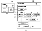
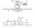
- FIG. 1 It is a block diagram which shows the spatial information detection apparatus and human position detection apparatus which concern on embodiment. It is a schematic block diagram which shows the usage example of the spatial information detection apparatus and human position detection apparatus which concern on embodiment.
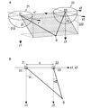
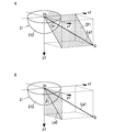
- 3A and 3B are diagrams illustrating the principle of the measurement device used in the embodiment.
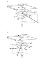
- 4A and 4B are diagrams illustrating the principle of the measuring device used in the embodiment.
- 5A and 5B are diagrams illustrating the principle of the measurement device used in the embodiment.
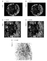
- 6A to 6E are diagrams showing examples of images in the measuring apparatus used in the embodiment.
- Measurement device In the embodiment described below, a measurement device that measures the three-dimensional data of the target space using the stereo vision technique is exemplified.
- the technique for measuring the three-dimensional data is not limited to the stereo vision, and the time of flight or phase Various known techniques such as shift can be employed.
- the measuring device 20 of the present embodiment uses the technology of stereo vision, as shown in FIG. 2, it includes a plurality of cameras 21 and 22 (two in the illustrated example) that image the target space. Although it is assumed that the cameras 21 and 22 output grayscale images, the technical concept described below can be applied when the cameras 21 and 22 output color images.
- the camera 21 includes an image sensor 211 and a light receiving optical system 212.
- the camera 22 includes an image sensor 221 and a light receiving optical system 222.
- As the image sensors 211 and 221 known solid-state image sensors such as a CCD image sensor and a CMOS sensor are used.
- the light receiving optical systems 212 and 222 are optical systems that receive light from the target space.
- the light receiving optical systems 212 and 222 are wide-angle lenses, desirably fish-eye lenses or lenses having a function corresponding to fish-eye lenses, and the cameras 21 and 22 each have an angle of view close to 180 degrees.
- the light receiving optical systems 212 and 222 are each schematically represented by one hemispherical lens.
- the projection method of the light receiving optical systems 212 and 222 may be any of the equidistant projection method, the stereoscopic projection method, the equisolid angle projection method, and the orthographic projection method, but will be described below using the equidistant projection method.
- two cameras 21 and 22 have a line segment (hereinafter referred to as “baseline”) in which the optical axes are parallel and the optical centers O1 and O2 of both cameras 21 and 22 are connected.
- the parallel stereo method is used, which is arranged perpendicular to both optical axes. Therefore, the entire fields of view of the two cameras 21 and 22 overlap.
- the direction of the baseline is made to coincide with the horizontal direction of an image (hereinafter referred to as “captured image”) obtained by capturing each of the cameras 21 and 22.
- the length of the baseline (hereinafter referred to as “baseline length”) and two Information on the distance of the image position deviation corresponding to the point of interest Q in the target space is necessary.
- the distance of the image position deviation is the parallax when the region of interest in the target space is viewed from the two cameras 21 and 22, from the reference position defined in each of the two captured images to the image position.
- the distance difference is the distance from the reference position to the image position in the captured image captured by the camera 21 and the position of the image from the reference position in the captured image captured by the camera 22. It is the difference with the distance to.
- the distance of the image position corresponding to the point of interest Q is the parallax when the point of interest Q is viewed from the two cameras 21 and 22.
- the parallax from the two captured images it is necessary to find the position of the image corresponding to the region of interest in the target space among the two captured images. That is, it is necessary to specify corresponding points corresponding to the same part in the two captured images.
- the process of searching for corresponding points from two captured images is called stereo matching.
- the range for searching for corresponding points on two captured images in stereo matching is as follows. It can be limited to a line obtained by projecting an epipolar surface on the image.
- the direction along the horizontal direction of the light receiving surface is the x direction
- the direction along the vertical direction with respect to the x direction on the light receiving surface is the y direction
- a device coordinate system in which the direction orthogonal to the light receiving surface is the z direction is defined.
- the x direction (first direction of the apparatus coordinate system) matches the direction of the baseline
- the right direction in the horizontal direction of the captured image is the positive direction of the x direction.
- the camera coordinate system for each of the cameras 21 and 22 is defined.
- the camera coordinate system has coordinate axes parallel to the coordinate axes of the apparatus coordinate system, but the origin uses optical centers O1 and O2 for the cameras 21 and 22, respectively.
- the coordinate axes of the camera coordinate system defined for the camera 21 are represented by x1, y1, z1, and the coordinate axes of the camera coordinate system defined for the camera 22 are x2, y2. , Z2.
- the z1 axis coincides with the optical axis of the camera 21, and the z2 axis coincides with the optical axis of the camera 22.
- the apparatus coordinate system matches the camera coordinate system set for the camera 21.
- the direction of looking at the target point Q of the target space from the optical center O1 that is the origin is, as shown in FIG. 4A, the angle ⁇ 1 with respect to the z1 axis and the target point Q from the optical center O1. This is expressed using an angle ⁇ 1 around the z1 axis from the x1 axis when the direction to be seen is projected onto the x1y1 plane.
- the distance r1 from the optical center O1 to the point where the point of interest Q is projected on the x1y1 plane is used. As shown in FIG.
- the camera coordinate system related to the other camera 22 has the same relationship. That is, in the camera coordinate system relating to the camera 22, in order to describe the position of the point of interest Q, the angle ⁇ 2 with respect to the z2 axis and the direction in which the point of interest Q is viewed from the optical center O2 are projected on the x2y2 plane from the x2 axis to z2. The angle ⁇ 2 around the axis and the distance r2 from the optical center O2 to the point where the point of interest Q is projected onto the x2y2 plane are used.
- the parallelogram shown at the top represents a captured image.
- an image coordinate system that is a two-dimensional orthogonal coordinate system with the upper left corner of the captured image as the origin is used to represent the position of the pixel in the captured image obtained for each of the cameras 21 and 22.
- the horizontal direction (first direction of the image coordinate system) of the captured image is in the x1 direction (first direction of the apparatus coordinate system).
- the vertical direction (second direction of the image coordinate system) in the captured image is set to be along the y1 direction (second direction of the apparatus coordinate system) in the captured image, and an arbitrary coordinate position in the captured image Is represented by (u1, v1).
- the image coordinate system of the captured image obtained by the camera 22 is set so that the horizontal direction of the captured image is along the x2 direction and the vertical direction with respect to the horizontal direction of the captured image is along the y2 direction.
- An arbitrary coordinate position in the captured image is represented by (u2, v2).
- the coordinate position (u1, v1) of the image coordinate system of the captured image obtained by the camera 21 and the coordinate position (u2, v2) of the image coordinate system of the captured image obtained by the camera 22 will be described without distinction. In this case, the coordinate position (u, v) is used.
- the measuring device 20 includes an arithmetic processing unit 23 that calculates the three-dimensional data of the target space using the captured images captured by the cameras 21 and 22.
- the arithmetic processing unit 23 includes a processor and a memory as hardware resources, and an interface unit for inputting and outputting data, and executes a program for causing the device to function as a device that performs processing described below.
- the device constituting the arithmetic processing unit 23 may be a digital signal processor (DSP), a field-programmable gate array (FPGA), or the like in addition to a microcomputer.
- DSP digital signal processor
- FPGA field-programmable gate array
- a device having a function of executing a program that is, a device corresponding to a computer
- the arithmetic processing unit 23 may be configured by dedicated hardware.
- Equation 1 is established between the coordinates (u, v).
- f is a proportionality constant in the equidistant projection method.
- the coordinates of the optical center O1 projected on the captured image captured by the camera 21 are (uc1, vc1), and the optical center projected on the captured image captured by the camera 22 is used.
- the coordinates of O2 be (uc2, vc2).
- the point of interest Q in the target space is projected onto a spherical surface having a radius of 1 centered on the optical centers O1 and O2 of the cameras 21 and 22.
- the orthogonal coordinates (xa, ya, za) of the camera coordinate system of the point where the point of interest Q is projected on the spherical surface the polar coordinates (r, ⁇ , ⁇ ) of the camera coordinate system described above are used, Equation 2 is obtained. It is expressed in A similar relationship is obtained for both cameras 21 and 22.
- the orthogonal coordinates (xa1, ya1, za1) of the camera coordinate system of the point where the point of interest Q is projected onto the spherical surface are the polar coordinates (r1, ⁇ 1, ⁇ 1) of the camera coordinate system.
- the orthogonal coordinates (xa2, ya2, za2) of the camera coordinate system at the point where the point of interest Q is projected onto the spherical surface are expressed using the polar coordinates (r2, ⁇ 2, ⁇ 2) of the camera coordinate system.
- the arithmetic processing unit 23 of the present embodiment has a function of converting an image represented by coordinates (u, v) into an image represented using angles ( ⁇ , ⁇ ).
- the angle ⁇ 1 is such that a straight line La1 that looks at the point of interest Q from the optical center O1 is in a plane including the x1 axis and the point of interest Q (corresponding to the epipolar plane EP1) with respect to the y1z1 plane. It is the angle to be made.
- the angle ⁇ 1 is an angle formed by the straight line La2 obtained by projecting the straight line La1 that looks at the point of interest Q from the optical center O1 on the y1z1 plane with respect to the z1 axis.
- the angle ⁇ 1 is an angle formed by the epipolar plane EP1 with respect to the z1 axis.
- the angle ⁇ 1 is 0 degree on the y1z1 plane, and the angle ⁇ 1 is 0 degree on the z-axis. Therefore, when the angle ( ⁇ , ⁇ ) is expressed using the coordinates (xa, ya, za), the relationship of Equation 3 is obtained.
- Equation 1 to Equation 3 When the relationship of Equation 1 to Equation 3 is applied to all pixels of the captured image, the relationship of the coordinates (xa, ya, za) expressed using the coordinates (u, v) of the image coordinate system is the angle ( ⁇ , ⁇ ). It will be represented by When an image having the angle ⁇ as the horizontal direction and the angle ⁇ as the vertical direction is generated, the pixel position is represented by the angle ( ⁇ , ⁇ ) from the captured image in which the pixel position is represented by the coordinates (u, v). Converted to an image.
- an image in which pixel positions are represented by angles ( ⁇ , ⁇ ) is referred to as a “transformed image”.
- the arithmetic processing unit 23 performs the same conversion on the captured image captured by the other camera 22 to generate a converted image.
- 6A illustrates an example of a captured image captured by the camera 21
- FIG. 6B illustrates an example of a captured image captured by the camera 22.
- 6C illustrates an example of a converted image corresponding to the captured image illustrated in FIG. 6A
- FIG. 6D illustrates an example of a converted image corresponding to the captured image illustrated in FIG. 6B.
- the angles ⁇ 1 and ⁇ 2 (see FIG. 3A) for viewing the same point of interest Q coincide. That is, in stereo matching described later, attention should be paid to the angles ⁇ 1 and ⁇ 2 (see FIG. 3A) of the converted image, and the stereo matching process is simplified.
- the arithmetic processing unit 23 estimates the parallax of the cameras 21 and 22 using the obtained two converted images, and uses the estimated parallax for calculating the three-dimensional data of the target space. In order to estimate the parallax of the cameras 21 and 22, the arithmetic processing unit 23 extracts corresponding points corresponding to the same position in the target space from the two converted images.
- the technique for extracting the corresponding points is not particularly limited, but in this embodiment, a block matching technique is adopted.
- the arithmetic processing unit 23 performs the coordinate ( ⁇ 2) of the corresponding point from the converted image with respect to the captured image of the camera 22 with respect to the coordinates ( ⁇ 1, ⁇ 1) of the point extracted from the converted image with respect to the captured image of the camera 21 by block matching. , ⁇ 2).
- I1 ( ⁇ 1 + i, ⁇ 1 + j) and I2 ( ⁇ 2 + i, ⁇ 2 + j) are luminance values for each converted image, and the block size is (2N + 1) pixels in the horizontal direction and (2M + 1) pixels in the vertical direction. N and M are natural numbers determined as appropriate.
- Equation 4 evaluates the sum of the differences (absolute values) of pixel values (luminance values) I1 ( ⁇ 1 + i, ⁇ 1 + j) and I2 ( ⁇ 2 + i, ⁇ 2 + j) for the pixel position (i, j) set in the converted image.
- R used for R. That is, as the evaluation value R, SAD (Sum of Absolute Difference) is used. However, as the evaluation value R, an SSD (Sum of Squared Difference) or a normalized cross-correlation function can be used.
- block matching is performed in order to obtain corresponding points, but other techniques of stereo matching may be employed, and stereo matching may be performed without using a converted image.
- the converted image is an image in which the horizontal axis of the image is ⁇ and the vertical axis is ⁇ , but an image converted by another conversion method may be used.
- the arithmetic processing unit 23 calculates the three-dimensional coordinates of the corresponding points (that is, the point of interest Q) in the target space by using the principle of the triangulation method. As shown in FIGS. 3A and 3B, when the angles ( ⁇ 1, ⁇ 1) and ( ⁇ 2, ⁇ 2) for viewing the point of interest Q from the origin of the camera coordinate system set for each of the two cameras 21 and 22 are used, the apparatus coordinate system is used.
- the arithmetic processing unit 23 calculates the distance Lq by performing the calculation of Equation 6 for all the target points Q in the target space, and generates a distance image with the pixel values at the coordinates ( ⁇ 1, ⁇ 1) of the converted image as the distance Lq.
- the measurement device 20 obtains three-dimensional data of the target space, and further generates a parallax image whose pixel value is the parallax Dq and a distance image whose pixel value is the distance Lq.
- the target space is an indoor space of a building and the reference surface is a floor surface will be described as an example.
- the target space may be an outdoor space of a building or a space formed outside the building.
- the reference surface is a wall surface, a ceiling surface, a desk surface, or the like, a technique similar to the technique described below can be employed.
- the target space is the indoor space of the building and the reference plane is the floor.
- the measuring device 20 has the optical axes of the cameras 21 and 22 facing downward near the center of the ceiling 51, as shown in FIG. A description will be given based on the case where they are arranged.
- the xy plane in the device coordinate system defined in the measuring device 20 is not always parallel to the floor surface 50, and in some cases, the measuring device 20 cannot be disposed on the ceiling 51. In some cases, it may be placed on the wall.
- the spatial information detection device 10 includes an acquisition unit 11 that acquires three-dimensional data from the measurement device 20 and a storage unit 12 that stores the three-dimensional data acquired by the acquisition unit 11.
- the acquisition unit 11 is an interface unit for connecting the measurement device 20, and is configured according to a communication specification in which the measurement device 20 outputs three-dimensional data.
- the storage unit 12 includes a first storage unit 121 that stores three-dimensional data (first three-dimensional data) for each measurement by the measurement device 20. Further, the storage unit 12 compares the reference three-dimensional data (second three-dimensional data) measured by the measurement device 20 at a predetermined timing with the measurement measured by the measurement device 20 to detect a change in the target space. 2nd memory
- storage part 122 which memorize
- the three-dimensional data stored in the first storage unit 121 is acquired for each frame of the captured image captured by the cameras 21 and 22.
- the frame rate of the captured image may be 30 frames per second as in a general moving image, but is appropriately set within a range of about 0.1 to 30 frames per second depending on the level of allowable processing load. Is done.
- the reference three-dimensional data (second three-dimensional data) stored in the second storage unit 122 is measured by the measurement device 20 at a timing when there is no moving object in the visual field of the measurement device 20, and is acquired by the acquisition unit 11. Is preferably obtained from the measuring device 20. If there is a moving object, an image having the pixel value as the median luminance of images taken at consecutive different times may be created, and the reference three-dimensional data may be obtained from the image.
- the reference three-dimensional data is so-called background three-dimensional data. When the difference between the comparison three-dimensional data (third three-dimensional data) and the background three-dimensional data is obtained, whether there is a change in the target space. And where the change occurred.
- storage part 122 is used as a one part component of the human position detection apparatus 30 mentioned later.
- the spatial information detection apparatus 10 uses the three-dimensional data stored in the first storage unit 121 to identify the floor surface 50 included in the captured image, and uses the entire floor surface 50 of the target space as a reference plane.
- a reference setting unit 13 is provided. Data regarding the floor surface 50 included in the captured image is included in the three-dimensional data stored in the first storage unit 121.
- the reference surface defined by the reference setting unit 13 includes not only the floor surface 50 included in the captured image but also the floor surface 50 hidden by a fixture or the like arranged in the target space. That is, the reference setting unit 13 estimates the floor surface 50 in an area that is not visible in the captured image, based on information on the floor surface 50 that is visible in the captured image captured by the cameras 21 and 22 provided in the measurement device 20. In addition, the estimated floor surface 50 is used as a reference surface.
- the device coordinate system In the state where the measuring device 20 is installed, the device coordinate system is known, but the spatial coordinate system defined in the target space is unknown. Therefore, in order for the reference setting unit 13 to determine the reference plane, information on the orientation of the reference plane and the distance to the reference plane in the apparatus coordinate system set in the measurement apparatus 20 is required.
- the spatial information detection device 10 sets a plurality of small planes in a region of interest including the floor 50 in the target space, and obtains the orientation of each of the plurality of small planes in the coordinate system defined by the measurement device 20.
- An element calculation unit 14 is provided.
- the plurality of small planes are set by dividing the entire region of interest, or are set at appropriate intervals in the region of interest.
- the surface element calculation unit 14 obtains a normal vector for each small plane using the three-dimensional data in the region of interest, and sets the direction represented by the normal vector as the direction of the small plane.
- the region of interest is a partial region in the target space in order to determine a reference plane for measuring the target space, and is extracted in advance before the surface element calculation unit 14 determines the orientations of a plurality of small planes.
- the size of the normal vector of the surface element represents the area of the surface element, but in this embodiment, the area of the small plane is not used.
- the measuring device 20 is arranged with the position accurately aligned with respect to the ceiling 51. That is, the measuring device 20 is arranged so that the optical axes of the cameras 21 and 22 (that is, the z axis of the device coordinate system) are parallel to one axis (Z axis) of the spatial coordinate system defined in the target space.
- the Z-axis of the spatial coordinate system is orthogonal to the floor surface 50
- the X-axis and Y-axis of the spatial coordinate system are set in appropriate directions orthogonal to each other and orthogonal to the Z-axis.
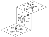
- the surface element calculation unit 14 extracts a combination of adjacent three points P0i, P1i, P2i from the three-dimensional data acquired by the acquisition unit 11 from the measuring device 20 (i is a natural number).
- the normal vector [Ni] of the small plane defined by the extracted three points is calculated.
- the circles in FIG. 7 represent points where three-dimensional data is obtained.
- the distances between the three points P0i, P1i, and P2i that define the small plane are preferably as small as possible. However, it is not essential that the distance between the three points is the minimum, and any distance that allows evaluation of the reference plane is acceptable. Is done.
- the two points P1i and P2i that are the distance range defined from one point P0i may be selected.
- the three points P0i, P1i, and P2i that define the small plane are obtained in the region of interest that is a part of the region for which three-dimensional data is obtained in the target space, but the three-dimensional in the target space. You may obtain
- vectors [V1i] and [V2i] from one point P0i out of the extracted three points P0i, P1i and P2i to the other two points P1i and P2i, the vectors are defined by three points P0i, P1i and P2i.
- the normal vector [Ni] of the small plane is expressed by the outer product [V1i] ⁇ [V2i] of the vectors [V1i] and [V2i].
- the z-axis of the device coordinate system is parallel to the Z-axis of the spatial coordinate system. Therefore, if the small plane is a part of the floor surface 50, the outer product [V1i] ⁇ [V2i] of the vectors [V1i] and [V2i] is parallel to the z-axis of the apparatus coordinate system.
- the direction of the outer product [V1i] ⁇ [V2i] changes depending on the direction of the vectors [V1i] and [V2i]
- the direction of the small plane is opposite depending on how [V1i] and [V2i] are set.
- the normal vector [Ni] of the floor surface 50 must be in the same direction.
- the normal vector [Ni] of the small plane used to define the reference plane is positive in the direction from the small plane toward the measuring device 20. For this reason, when the direction of the normal vector [Ni] of the small plane is downward, the sign is inverted so as to be upward.
- the small plane may be formed in a part other than the floor surface 50, and the small plane other than the floor surface 50 needs to consider the direction if it is a real space. Since the focus is on the small plane for defining the reference plane, the same rule is applied to small planes other than the floor 50. That is, the sign is ignored for all facets.
- the region of interest can be only the floor surface 50. Therefore, normal vectors of a plurality of small planes obtained from the region of interest [ Ni] is considered to be in substantially the same direction. In such a case, the orientation of the reference plane can be determined by obtaining the average of the orientations of the normal vectors [Ni] of the obtained plurality of small planes.
- the spatial information detection apparatus 10 of the present embodiment extracts the floor surface 50 from the region of interest by using the frequency distribution for the directions of the normal vectors [Ni] of the plurality of small planes calculated by the surface element calculation unit 14. .
- the surface element calculation unit 14 may determine a region of interest using a plurality of sets of three-dimensional data obtained from captured images of a plurality of frames captured by the cameras 21 and 22 of the measurement device 20.
- the surface element calculation unit 14 extracts a region of interest from a region in the target space that is within an error range defined by a change in the three-dimensional data stored in the first storage unit 121.
- the surface element calculation unit 14 obtains a difference in z coordinates for each same position on the xy plane as a change in a plurality of three-dimensional data, and extracts a part where the difference is within an error range as a region of interest.
- each of the plurality of three-dimensional data includes an x-coordinate (first coordinate) and a y-coordinate (second coordinate) representing a position in a direction parallel to the light receiving surface of the measuring device 20 as a device coordinate system, and a device And a z coordinate (third coordinate) representing a position in a direction orthogonal to the light receiving surface in the coordinate system.
- the surface element calculation part 14 calculates
- the reliability of the normal vector [Ni] obtained from the three-dimensional data may be reduced due to irregular measurement errors in the measurement apparatus 20 and the presence of moving objects in the target space. Therefore, normal vectors [Ni] are obtained from a plurality of sets of three-dimensional data, and normal processing is performed on the direction of the normal vectors [Ni] (for example, averaging and removal of outliers) to obtain normal vectors. It is desirable to increase the reliability of the direction of the vector [Ni]. That is, the surface element calculation unit 14 obtains orientation candidates for each of the plurality of small planes a plurality of times from a plurality of sets of three-dimensional data measured by the measuring device 20 at different times, and each direction of the plurality of small planes. It is desirable to determine the orientation of each of the plurality of facets by statistical processing on the candidates.
- the orientation of the normal vector [Ni] of the small plane is represented by a coherence angle ( ⁇ ) and an azimuth angle ( ⁇ ) of the dip angle using a device coordinate system based on spherical coordinates.
- the angle ⁇ is an angle formed by a straight line that looks at the starting point of the normal vector [Ni] from the origin of the apparatus coordinate system with respect to the z axis of the apparatus coordinate system, and the angle ⁇ is a normal to the xy plane of the apparatus coordinate system. This is the angle formed by the projection of the vector [Ni] with respect to the x axis.
- the angle ( ⁇ , ⁇ ) representing the direction of the normal vector [Ni] for each small plane is defined by the following equation.
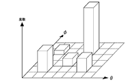
- the spatial information detection apparatus 10 includes a distribution extraction unit 15 that obtains a frequency distribution with respect to the direction of the normal vector [Ni] for each small plane.
- the distribution extraction unit 15 divides the angle ( ⁇ , ⁇ ) indicating the direction of the normal vector [Ni] into sections of a predetermined width to obtain a frequency distribution. In other words, this corresponds to quantizing the angle ( ⁇ , ⁇ ) and obtaining the frequency distribution for the angle ( ⁇ , ⁇ ) after quantization.
- Quantization can be performed simply by quantizing to an integer value with the unit of angle ( ⁇ , ⁇ ) being [degrees]. In this case, the frequency is obtained by dividing into sections of 1 degree.
- the quantization step size can be set as appropriate, and the step size may be narrowed to increase the accuracy.
- the reference setting unit 13 determines the distribution. In the frequency distribution obtained by the extraction unit 15, a direction that is a frequency equal to or higher than a specified direction threshold value can be determined as the direction of the floor surface 50.
- the distribution extraction unit 15 sets a constraint condition so as to obtain a frequency distribution for a direction within a specified direction range among a plurality of facet directions. It is desirable to keep it.
- the purpose is to extract the floor surface 50, and since the measuring device 20 is disposed on the ceiling 51 (see FIG. 2), it is considered that the angle ⁇ is concentrated in the vicinity of zero. Therefore, when the distribution extraction unit 15 obtains the frequency distribution for only the normal vector [Ni] within the predetermined angle range from 0 with respect to the angle ⁇ among the plurality of small-plane normal vectors [Ni], the processing is performed. In addition to greatly reducing the load, the possibility of extracting other than the floor surface 50 is reduced.
- the spatial information detection device 10 includes a communication unit that receives an instruction of an angle range from the input unit, and a storage unit that stores a constraint condition. Is desirable. If the angle range is limited for the angle ⁇ , the normal vector [Ni] in a direction clearly different from the reference plane is excluded. Therefore, it is possible to accurately determine the reference plane even in a complicated shape in which many normal vectors [Ni] in a direction different from the reference plane exist within the measurement range of the measuring device 20.
- the desk surface 41 and the seat surface 42 of a chair, and the floor surface 50 are substantially. Since it is considered to be parallel (see FIG. 2), there is a possibility that the desk surface 41 and the seating surface 42 may be mistaken for the floor surface 50 only by the information of the frequency distribution of the angles ( ⁇ , ⁇ ).
- the measuring device 20 is arranged in the upper part of the target space such as the ceiling 51, the distance from the floor surface 50 is larger than the distance from the desk top surface 41, the seating surface 42, the shelf top surface, and the like. it is conceivable that.
- the reference setting unit 13 extracts the small planes included in the frequency equal to or higher than the direction threshold in the frequency distribution of the angles ( ⁇ , ⁇ ), and the measuring device 20 in the normal direction for each extracted small plane.
- the distance that is, the height
- the facet having the maximum obtained distance is determined.
- the small plane with the maximum distance is determined by the following method, for example.
- the reference setting unit 13 obtains a frequency distribution with the abscissa indicating the distance (height) of the extracted small plane.
- the reference setting unit 13 applies a general mixed normal distribution to the obtained frequency distribution, and applies a plurality of normal distributions.
- the reference setting unit 13 sets the small plane closest to the average as the small plane having the maximum distance.
- This method is an example, and the facet with the maximum distance may be determined by other methods.
- the reference setting unit 13 extracts the small planes that are candidates for the reference plane by using the orientations of the plurality of small planes, and the distance from the measuring device 20 in the direction of the normal of the small plane that is the candidate for the reference plane. To extract a small plane included in the reference plane.
- the three-dimensional data (xp, yp, zp) of the starting point of the vector it is obtained as nx ⁇ xp + ny ⁇ yp + nz ⁇ zp. That is, the height of the measuring device 20 in the direction of the normal vector is obtained from the inner product of the normal vector of the small plane and the position vector representing the position of the start point of the normal vector.
- the distance between the measurement device 20 and the small plane in the normal direction of the small plane is compared with the distance threshold.
- the frequency is equal to or greater than a predetermined threshold using the frequency distribution of the distance, and the frequency A small plane belonging to a section having the maximum distance in the distribution may be extracted.
- the obtained distance may be quantized to obtain the frequency, and a facet having a relatively high frequency and a maximum quantized distance may be extracted.
- the reference setting unit 13 extracts a small plane estimated to be included in the reference plane from a plurality of small planes, and then sets the reference plane using the extracted small plane. That is, the reference setting unit 13 fits the extracted small plane on one plane and uses this plane as the reference plane (floor surface 50).
- a known technique such as the least square method or RANSAC (RANdomRANSAmple Consensus) is used.
- the direction in which the frequency is maximized is defined as the Z direction (the third direction of the spatial coordinate system), and a spatial coordinate system is defined in which the plane orthogonal to the Z direction is the XY plane. It becomes possible.
- the X direction (the first direction in the spatial coordinate system) and the Y direction (the second direction in the spatial coordinate system) can be appropriately set in the XY plane. It is desirable to set the X direction and the Y direction based on the above.
- the x-axis and the y-axis in the device coordinate system of the measuring device 20 may be projected onto the XY plane, the x-axis projection may be the X-axis, and the y-axis projection may be the Y-axis.
- the set coordinate values of the spatial coordinate system are stored in the storage unit 12 in association with the coordinate values of the apparatus coordinate system. Accordingly, the storage unit 12 stores data for coordinate conversion from the device coordinate system to the spatial coordinate system.
- the spatial coordinate system By determining the spatial coordinate system, coordinate conversion from the three-dimensional data of the device coordinate system to the spatial coordinate system becomes possible. That is, it is possible to obtain the height of the object relative to the reference plane (floor surface 50) using the three-dimensional data of the object existing in the target space.
- the calculation for calculating the height of the object with respect to the reference plane is performed by the height calculation unit 16 provided in the spatial information detection device 10. Since the height calculation unit 16 determines the height of the object with respect to the floor surface 50, the three-dimensional shape of the object is determined by combining with the outer peripheral shape of the object along the floor surface 50.
- the light receiving optical systems 212 and 222 of the measuring device 20 are fisheye lenses or lenses having a function corresponding to the fisheye lens, in the captured image, the periphery is closer to the central region near the optical axes of the cameras 21 and 22.
- the amount of information per unit area is larger in the side area. Therefore, the measurement accuracy is higher in the central area of the captured image than in the peripheral area of the captured image. That is, since the variable range of the angle ⁇ is 0 ⁇ ⁇ ⁇ ⁇ / 2, the measurement accuracy increases when the angle ⁇ is near 0, and the measurement accuracy decreases when the angle ⁇ is near ⁇ / 2.
- the distribution extraction unit 15 multiplies the frequency by a weighting factor according to the position of the three-dimensional data for which the angle ( ⁇ , ⁇ ) has been obtained. It is desirable.
- the weighting factor is preferably obtained by multiplying the three-dimensional data corresponding to the central region of the captured image by a larger weighting factor than the three-dimensional data corresponding to the peripheral region of the captured image.
- the weighting coefficient w is determined as follows.
- the weight distribution is set according to the information amount and the frequency distribution is obtained, thereby obtaining the information obtained from the frequency distribution. It becomes possible to increase reliability. That is, the reliability of reference plane extraction based on the frequency distribution is increased.
- the frequency distribution of the angle ( ⁇ , ⁇ ) is generated using the three-dimensional data obtained by one imaging, but the position of the measuring device 20 is fixed, and thus the plurality of times.
- the frequency distribution may be generated using the three-dimensional data obtained by imaging.
- the frequency difference is widened, so that discrimination based on the orientation threshold becomes easier.
- the reference plane is detected using the frequency distribution of the normal direction of the small plane (that is, the angle ( ⁇ , ⁇ )), the reference plane can be detected easily and accurately. Moreover, since the reference plane is estimated in consideration of the distance from the measuring device 20 to the reference plane, when detecting the floor 50, the floor 50 such as the desk top 41, the chair seat 42, or the shelf top. It is possible to prevent erroneous detection of a plane parallel to the. That is, when detecting the position of a person, which will be described later, it is possible to detect the position of the person 40 (see FIG. 2) excluding the area where the desks and shelves are arranged.
- the spatial information detection device 10 Since the spatial information detection device 10 automatically obtains the inclination and distance of the reference surface with respect to the measurement device 20 and automatically extracts the relationship between the reference surface and the measurement device 20 in the target space, only the measurement device 20 is installed. Thus, conversion from the device coordinate system to the spatial coordinate system becomes possible. Further, by converting the three-dimensional data of the apparatus coordinate system into the three-dimensional data of the spatial coordinate system, it is possible to detect the height of the object with respect to the reference plane.
- the spatial information detection device 10 By using such a function of the spatial information detection device 10, it is possible to detect the presence / absence of the person 40 (see FIG. 2) and the position of the person 40 in the target space.
- a human position detection device 30 that detects the presence and position of the person 40 using the spatial information detection device 10 will be described with reference to FIG. 1.
- the human position detection device 30 uses both the reference three-dimensional data (second three-dimensional data) and the comparison three-dimensional data (third three-dimensional data) stored in the second storage unit 122.
- the presence / absence and position of 40 are detected.
- the second storage unit 122 stores a plurality of three-dimensional data acquired by the acquisition unit 11 at different times. Specifically, in the second storage unit 122, the reference three-dimensional data obtained during a period during which it is guaranteed that no person 40 exists in the target space and the comparison obtained during the period during which the target space is monitored. 3D data for use are stored.
- the reference three-dimensional data obtained during a period in which the person 40 does not exist in the target space is three-dimensional data corresponding to the background of the target space, it is hereinafter referred to as “background data”. Further, the comparison three-dimensional data obtained during the period of monitoring the target space is called “monitoring data” because it is the three-dimensional data to be monitored.
- the human position detection device 30 includes a difference calculation unit 31 that calculates a difference between the distance obtained using the monitoring data and the distance obtained using the background data, and the person 40 using the difference calculated by the difference calculation unit 31. And a human position estimating unit 32 for estimating the position where the
- the difference calculation unit 31 obtains a difference between the values of the distance Lq for each of the same coordinates ( ⁇ , ⁇ ) in the distance image between the monitoring data and the background data. That is, the difference calculation unit 31 extracts a part where a change has occurred with respect to the background data by obtaining the difference of the distance Lq from the measurement device 20.
- the region where the distance Lq has changed with respect to the background data is considered to correspond to the moved object, and since the moved object has the possibility of being a person 40, the difference between the monitoring data and the background data. If there is a region where the change occurs, this region is regarded as a candidate region of the person 40, that is, a candidate region where the person 40 exists. However, when the difference is small, there is a possibility of an error, and when the small animal moves in the target space, the difference may change.
- the human position estimation unit 32 defines the difference (difference between the monitoring data and the background data) obtained by the difference calculation unit 31 in order to detect the person 40 by removing the change in the difference due to an error or a small animal. If the determination threshold is exceeded, the region where the difference has changed is determined as a region that is a candidate for the person 40. That is, the human position estimation unit 32 binarizes the difference between the monitoring data and the background data by the determination threshold value.
- the binarized data is a binary image in which 1 is associated with pixels exceeding the threshold and 0 is associated with pixels below the threshold. That is, an area having a pixel value of 1 in this binary image is an area that is a candidate for the person 40.
- the person position estimation unit 32 applies the data stored in the storage unit 12 to the region that is a candidate for the person 40, and performs coordinate conversion from the device coordinate system to the spatial coordinate system. By this coordinate transformation, the height from the reference plane is obtained for the region that is a candidate for the person 40. Accordingly, the human position estimation unit 32 compares the height from the reference plane obtained from the candidate area of the person 40 with the height range specified based on the height of the person 40, thereby comparing the person 40 and the others. It is distinguished from the object. With this process, even objects that move, such as chairs, trash cans, and notebook computers, are excluded from the candidates for the person 40 if the height from the reference plane is not within the specified height range.
- the human position estimation unit 32 measures the height of the object existing in the target space from the reference plane using the estimated direction and distance of the reference plane, the person 40 and other objects are measured in height. Differentiating by difference, the possibility of misdetecting other objects is reduced. In addition, since the height range from the floor 50 that is the reference surface is defined, it is possible to prevent erroneous detection of an object having a height that is clearly different from the height of the person 40.
- the human position estimation unit 32 obtains the center of gravity of the regions that form the cluster among the detected candidates of the person 40 and sets the position of the person 40 projected on the reference plane as the position of the person 40.
- the area forming the cluster means a set of points that are distances within a predetermined threshold by evaluating the distance between the points (points corresponding to the pixels) included in the area.
- a known clustering method such as Mean-Shift clustering may be employed.
- the technique using the difference between the monitoring data that is three-dimensional data and the background data has been described.
- the candidate area of the person 40 is obtained using the difference between the parallax images generated by the measurement device 20. Is possible.
- the storage unit 12 stores the parallax Dq as a pixel value for each coordinate represented by angles ( ⁇ 1, ⁇ 1). Further, the difference calculation unit 31 obtains a difference between pixel values (parallax Dq) of the same coordinates ( ⁇ 1, ⁇ 1).
- the process performed by the human position estimation unit 32 is the same as the case of using three-dimensional data, and binarizes and extracts a region where the difference has changed, converts this region into height information from the reference plane,
- the center of gravity of the cluster may be the position of the person 40.
- the candidate area of the person 40 may be obtained by using the three-dimensional data and the parallax image together. That is, as described above, an area that is a candidate of the person 40 extracted by binarizing the difference of the three-dimensional data and an area of the candidate of the person 40 extracted by binarizing the difference of the parallax images Alternatively, the coordinates may be combined after the coordinate conversion, and the combined area may be used as a candidate area for the person 40. For the synthesis of the regions, if logical sum is used, the candidate regions of the person 40 can be easily detected, and if logical product is used, the candidate regions of the person 40 are narrowed down.
- the operation of the human position detecting device 30 in cooperation with the spatial information detecting device 10 is collectively shown in FIG.
- the illustrated example shows a case where three-dimensional data (distance image) is used.
- the acquisition unit 11 of the spatial information detection device 10 acquires background data (second three-dimensional data) (S11), and stores the background data in the second storage unit 122 (S12).
- the reference setting unit 13 of the spatial information detection device 10 calculates the orientation and distance of the floor surface 50 (S13, S14), and stores data for coordinate conversion from the device coordinate system to the spatial coordinate system in the storage unit 12. Store (S15).
- the acquisition unit 11 of the spatial information detection device 10 acquires monitoring data (third three-dimensional data) (S16), and the difference calculation unit 31 of the human position detection device 30 uses the difference between the monitoring data and the background data.
- a candidate area for the person 40 is extracted (S17).
- the human position estimating unit 32 of the human position detecting device 30 evaluates whether or not the person 40 exists in the area based on the height from the floor 50 (S18), and evaluates that the person 40 exists in the area.
- the person position detecting device 30 calculates the center of gravity of the area forming the cluster as the position of the person 40 (S19).
- the operations in steps S16 to S19 including acquisition of monitoring data are repeated at appropriate time intervals until the monitoring is completed (S20: Yes).
- the measurement device 20 and the spatial information detection device 10 are described as separate bodies. However, these devices are integrated into a single housing and configured. Also good.
Landscapes
- Physics & Mathematics (AREA)
- General Physics & Mathematics (AREA)
- Engineering & Computer Science (AREA)
- Theoretical Computer Science (AREA)
- Computer Vision & Pattern Recognition (AREA)
- Length Measuring Devices By Optical Means (AREA)
- Image Processing (AREA)
Abstract
La présente invention porte sur un dispositif de détection d'informations spatiales qui comprend une unité d'acquisition, une unité de réglage de référence et une unité de calcul de pixel. L'unité d'acquisition acquiert des données tridimensionnelles en rapport avec un espace sujet qu'un dispositif de mesure a mesuré. L'unité de calcul de pixel règle une pluralité de petits plans dans une région d'intérêt dans l'espace sujet, et à l'aide des données tridimensionnelles dans les régions d'intérêt, déduit pour chaque petit plan une face dans un plan de coordonnées de dispositif qui est défini dans le dispositif de mesure et une distance depuis le dispositif de mesure. L'unité de réglage de référence définit un plan de référence pour mesurer l'espace sujet, sur la base de la face et de la distance que l'unité de calcul de pixel a déduit pour chaque petit plan.
Priority Applications (1)
| Application Number | Priority Date | Filing Date | Title |
|---|---|---|---|
| JP2014520893A JP5838355B2 (ja) | 2012-06-20 | 2013-05-27 | 空間情報検出装置、人位置検出装置 |
Applications Claiming Priority (2)
| Application Number | Priority Date | Filing Date | Title |
|---|---|---|---|
| JP2012139033 | 2012-06-20 | ||
| JP2012-139033 | 2012-06-20 |
Publications (1)
| Publication Number | Publication Date |
|---|---|
| WO2013190772A1 true WO2013190772A1 (fr) | 2013-12-27 |
Family
ID=49768387
Family Applications (1)
| Application Number | Title | Priority Date | Filing Date |
|---|---|---|---|
| PCT/JP2013/003322 Ceased WO2013190772A1 (fr) | 2012-06-20 | 2013-05-27 | Dispositif de détection d'informations spatiales et dispositif de détection de position de personne |
Country Status (2)
| Country | Link |
|---|---|
| JP (1) | JP5838355B2 (fr) |
| WO (1) | WO2013190772A1 (fr) |
Cited By (18)
| Publication number | Priority date | Publication date | Assignee | Title |
|---|---|---|---|---|
| JP2015224879A (ja) * | 2014-05-26 | 2015-12-14 | パイオニア株式会社 | 検出装置及び方法、コンピュータプログラム並びに記録媒体 |
| JP2016067800A (ja) * | 2014-10-01 | 2016-05-09 | パナソニックIpマネジメント株式会社 | 電気機器システム |
| JP2016212086A (ja) * | 2015-04-28 | 2016-12-15 | 三菱電機株式会社 | シーン内の寸法を求める方法 |
| JP2017162447A (ja) * | 2015-12-24 | 2017-09-14 | ダッソー システムズDassault Systemes | 量子化を用いた3dオブジェクトの位置特定 |
| JP2017168081A (ja) * | 2015-12-24 | 2017-09-21 | ダッソー システムズDassault Systemes | 記述子を用いた3dオブジェクトの位置特定 |
| JP2017219385A (ja) * | 2016-06-06 | 2017-12-14 | 株式会社デンソーアイティーラボラトリ | 物体検出装置、物体検出システム、物体検出方法、およびプログラム |
| CN107845131A (zh) * | 2016-09-20 | 2018-03-27 | 发那科株式会社 | 三维数据生成装置、三维数据生成方法以及监视系统 |
| JP2018151832A (ja) * | 2017-03-13 | 2018-09-27 | キヤノン株式会社 | 情報処理装置、情報処理方法、および、プログラム |
| JP2018179981A (ja) * | 2017-04-18 | 2018-11-15 | パナソニックIpマネジメント株式会社 | カメラ校正方法、カメラ校正プログラム及びカメラ校正装置 |
| JPWO2020217651A1 (fr) * | 2019-04-25 | 2020-10-29 | ||
| JP2021060784A (ja) * | 2019-10-07 | 2021-04-15 | 日本電気通信システム株式会社 | 物体検知装置、システム、方法、及びプログラム |
| JP2021066423A (ja) * | 2020-07-30 | 2021-04-30 | 株式会社センシンロボティクス | 飛行体、点検方法及び点検システム |
| JP2021075263A (ja) * | 2020-06-02 | 2021-05-20 | 株式会社センシンロボティクス | 飛行体、点検方法及び点検システム |
| JP2021075262A (ja) * | 2020-06-02 | 2021-05-20 | 株式会社センシンロボティクス | 飛行体、点検方法及び点検システム |
| CN115023736A (zh) * | 2019-12-13 | 2022-09-06 | 康诺特电子有限公司 | 用于测量环境地形的方法 |
| JPWO2022201786A1 (fr) * | 2021-03-22 | 2022-09-29 | ||
| JP2022183736A (ja) * | 2021-05-31 | 2022-12-13 | セイコーエプソン株式会社 | 検出方法、及び検出システム |
| JP2025089391A (ja) * | 2020-06-02 | 2025-06-12 | 株式会社センシンロボティクス | 飛行体、点検方法及び点検システム |
Citations (3)
| Publication number | Priority date | Publication date | Assignee | Title |
|---|---|---|---|---|
| JP2006053754A (ja) * | 2004-08-11 | 2006-02-23 | Honda Motor Co Ltd | 平面検出装置及び検出方法 |
| JP2008009999A (ja) * | 2007-07-27 | 2008-01-17 | Sony Corp | 平面抽出方法、その装置、そのプログラム、その記録媒体及び撮像装置 |
| JP2009174830A (ja) * | 2008-01-28 | 2009-08-06 | Sharp Corp | 人物位置検出装置および空気調和機 |
Family Cites Families (1)
| Publication number | Priority date | Publication date | Assignee | Title |
|---|---|---|---|---|
| JP4297501B2 (ja) * | 2004-08-11 | 2009-07-15 | 国立大学法人東京工業大学 | 移動体周辺監視装置 |
-
2013
- 2013-05-27 WO PCT/JP2013/003322 patent/WO2013190772A1/fr not_active Ceased
- 2013-05-27 JP JP2014520893A patent/JP5838355B2/ja not_active Expired - Fee Related
Patent Citations (3)
| Publication number | Priority date | Publication date | Assignee | Title |
|---|---|---|---|---|
| JP2006053754A (ja) * | 2004-08-11 | 2006-02-23 | Honda Motor Co Ltd | 平面検出装置及び検出方法 |
| JP2008009999A (ja) * | 2007-07-27 | 2008-01-17 | Sony Corp | 平面抽出方法、その装置、そのプログラム、その記録媒体及び撮像装置 |
| JP2009174830A (ja) * | 2008-01-28 | 2009-08-06 | Sharp Corp | 人物位置検出装置および空気調和機 |
Cited By (30)
| Publication number | Priority date | Publication date | Assignee | Title |
|---|---|---|---|---|
| JP2015224879A (ja) * | 2014-05-26 | 2015-12-14 | パイオニア株式会社 | 検出装置及び方法、コンピュータプログラム並びに記録媒体 |
| JP2016067800A (ja) * | 2014-10-01 | 2016-05-09 | パナソニックIpマネジメント株式会社 | 電気機器システム |
| JP2016212086A (ja) * | 2015-04-28 | 2016-12-15 | 三菱電機株式会社 | シーン内の寸法を求める方法 |
| JP2017162447A (ja) * | 2015-12-24 | 2017-09-14 | ダッソー システムズDassault Systemes | 量子化を用いた3dオブジェクトの位置特定 |
| JP2017168081A (ja) * | 2015-12-24 | 2017-09-21 | ダッソー システムズDassault Systemes | 記述子を用いた3dオブジェクトの位置特定 |
| JP7017852B2 (ja) | 2015-12-24 | 2022-02-09 | ダッソー システムズ | 記述子を用いた3dオブジェクトの位置特定 |
| JP2017219385A (ja) * | 2016-06-06 | 2017-12-14 | 株式会社デンソーアイティーラボラトリ | 物体検出装置、物体検出システム、物体検出方法、およびプログラム |
| CN107845131A (zh) * | 2016-09-20 | 2018-03-27 | 发那科株式会社 | 三维数据生成装置、三维数据生成方法以及监视系统 |
| US11039076B2 (en) | 2017-03-13 | 2021-06-15 | Canon Kabushiki Kaisha | Information processing apparatus, information processing method, and storage medium |
| JP2018151832A (ja) * | 2017-03-13 | 2018-09-27 | キヤノン株式会社 | 情報処理装置、情報処理方法、および、プログラム |
| JP2018179981A (ja) * | 2017-04-18 | 2018-11-15 | パナソニックIpマネジメント株式会社 | カメラ校正方法、カメラ校正プログラム及びカメラ校正装置 |
| JPWO2020217651A1 (fr) * | 2019-04-25 | 2020-10-29 | ||
| JP2021060784A (ja) * | 2019-10-07 | 2021-04-15 | 日本電気通信システム株式会社 | 物体検知装置、システム、方法、及びプログラム |
| JP7405395B2 (ja) | 2019-10-07 | 2023-12-26 | 日本電気通信システム株式会社 | 物体検知装置、システム、方法、及びプログラム |
| JP7502440B2 (ja) | 2019-12-13 | 2024-06-18 | コノート、エレクトロニクス、リミテッド | 環境のトポグラフィを測定するための方法 |
| JP2023505891A (ja) * | 2019-12-13 | 2023-02-13 | コノート、エレクトロニクス、リミテッド | 環境のトポグラフィを測定するための方法 |
| CN115023736A (zh) * | 2019-12-13 | 2022-09-06 | 康诺特电子有限公司 | 用于测量环境地形的方法 |
| US12217444B2 (en) | 2019-12-13 | 2025-02-04 | Connaught Electronics Ltd. | Method for measuring the topography of an environment |
| JP2025089391A (ja) * | 2020-06-02 | 2025-06-12 | 株式会社センシンロボティクス | 飛行体、点検方法及び点検システム |
| JP2021075262A (ja) * | 2020-06-02 | 2021-05-20 | 株式会社センシンロボティクス | 飛行体、点検方法及び点検システム |
| JP2021075263A (ja) * | 2020-06-02 | 2021-05-20 | 株式会社センシンロボティクス | 飛行体、点検方法及び点検システム |
| JP2021066423A (ja) * | 2020-07-30 | 2021-04-30 | 株式会社センシンロボティクス | 飛行体、点検方法及び点検システム |
| WO2022201786A1 (fr) * | 2021-03-22 | 2022-09-29 | ソニーグループ株式会社 | Dispositif de traitement d'informations, procédé de traitement d'informations et programme |
| JPWO2022201786A1 (fr) * | 2021-03-22 | 2022-09-29 | ||
| JP7726266B2 (ja) | 2021-03-22 | 2025-08-20 | ソニーグループ株式会社 | 情報処理装置、情報処理方法、及び、プログラム |
| CN115479538A (zh) * | 2021-05-31 | 2022-12-16 | 精工爱普生株式会社 | 检测方法以及检测系统 |
| JP7424348B2 (ja) | 2021-05-31 | 2024-01-30 | セイコーエプソン株式会社 | 検出方法、及び検出システム |
| JP2022183736A (ja) * | 2021-05-31 | 2022-12-13 | セイコーエプソン株式会社 | 検出方法、及び検出システム |
| US12270909B2 (en) | 2021-05-31 | 2025-04-08 | Seiko Epson Corporation | Detection method and detection system |
| CN115479538B (zh) * | 2021-05-31 | 2025-10-10 | 精工爱普生株式会社 | 检测方法以及检测系统 |
Also Published As
| Publication number | Publication date |
|---|---|
| JP5838355B2 (ja) | 2016-01-06 |
| JPWO2013190772A1 (ja) | 2016-02-08 |
Similar Documents
| Publication | Publication Date | Title |
|---|---|---|
| JP5838355B2 (ja) | 空間情報検出装置、人位置検出装置 | |
| EP2717013A1 (fr) | Dispositif caméra stéréo et support d'enregistrement pouvant être lu par ordinateur | |
| Diraco et al. | An active vision system for fall detection and posture recognition in elderly healthcare | |
| US9959455B2 (en) | System and method for face recognition using three dimensions | |
| EP2072947B1 (fr) | Dispositif de traitement d'image et procédé de traitement d'image | |
| KR102424135B1 (ko) | 2개의 카메라로부터의 곡선의 세트의 구조형 광 매칭 | |
| JP2014127208A (ja) | 物体検出方法及び物体検出装置 | |
| US9747690B2 (en) | Image processing device, image processing method, and program | |
| JP2013156718A (ja) | 人物追跡属性推定装置、人物追跡属性推定方法、プログラム | |
| US12395726B2 (en) | Methods and systems for performing object dimensioning | |
| EP2875314A1 (fr) | Balayage en 3 dimensions et interface de positionnement | |
| Kim et al. | Quasi-globally optimal and real-time visual compass in Manhattan structured environments | |
| Ruotsalainen et al. | Visual-aided two-dimensional pedestrian indoor navigation with a smartphone | |
| WO2019016879A1 (fr) | Dispositif et procédé de détection d'objet | |
| Ruotsalainen et al. | Heading change detection for indoor navigation with a smartphone camera | |
| Antunes et al. | Can stereo vision replace a laser rangefinder? | |
| Meers et al. | Face recognition using a time-of-flight camera | |
| Gallegos et al. | Appearance-based slam relying on a hybrid laser/omnidirectional sensor | |
| US20230326060A1 (en) | Methods and systems for performing object dimensioning | |
| Li et al. | Two-phase approach—Calibration and iris contour estimation—For gaze tracking of head-mounted eye camera | |
| JP2007114168A (ja) | 画像処理方法および装置、並びにプログラム | |
| Cupec et al. | Place recognition based on planar surfaces using multiple RGB-D Images taken from the same position | |
| Cordes et al. | Extrinsic calibration of a stereo camera system using a 3d cad model considering the uncertainties of estimated feature points | |
| Bräuer-Burchardt et al. | Comparison and evaluation of correspondence finding methods in 3D measurement systems using fringe projection | |
| Wang et al. | Support-plane estimation for floor detection to understand regions' spatial organization |
Legal Events
| Date | Code | Title | Description |
|---|---|---|---|
| 121 | Ep: the epo has been informed by wipo that ep was designated in this application |
Ref document number: 13806183 Country of ref document: EP Kind code of ref document: A1 |
|
| ENP | Entry into the national phase |
Ref document number: 2014520893 Country of ref document: JP Kind code of ref document: A |
|
| NENP | Non-entry into the national phase |
Ref country code: DE |
|
| 122 | Ep: pct application non-entry in european phase |
Ref document number: 13806183 Country of ref document: EP Kind code of ref document: A1 |