WO2016068275A1 - 情報処理装置及び測位装置 - Google Patents
情報処理装置及び測位装置 Download PDFInfo
- Publication number
- WO2016068275A1 WO2016068275A1 PCT/JP2015/080657 JP2015080657W WO2016068275A1 WO 2016068275 A1 WO2016068275 A1 WO 2016068275A1 JP 2015080657 W JP2015080657 W JP 2015080657W WO 2016068275 A1 WO2016068275 A1 WO 2016068275A1
- Authority
- WO
- WIPO (PCT)
- Prior art keywords
- information
- observation
- reinforcement information
- positioning
- error
- Prior art date
- Legal status (The legal status is an assumption and is not a legal conclusion. Google has not performed a legal analysis and makes no representation as to the accuracy of the status listed.)
- Ceased
Links
Images






Classifications
-
- G—PHYSICS
- G01—MEASURING; TESTING
- G01S—RADIO DIRECTION-FINDING; RADIO NAVIGATION; DETERMINING DISTANCE OR VELOCITY BY USE OF RADIO WAVES; LOCATING OR PRESENCE-DETECTING BY USE OF THE REFLECTION OR RERADIATION OF RADIO WAVES; ANALOGOUS ARRANGEMENTS USING OTHER WAVES
- G01S19/00—Satellite radio beacon positioning systems; Determining position, velocity or attitude using signals transmitted by such systems
- G01S19/01—Satellite radio beacon positioning systems transmitting time-stamped messages, e.g. GPS [Global Positioning System], GLONASS [Global Orbiting Navigation Satellite System] or GALILEO
- G01S19/03—Cooperating elements; Interaction or communication between different cooperating elements or between cooperating elements and receivers
- G01S19/07—Cooperating elements; Interaction or communication between different cooperating elements or between cooperating elements and receivers providing data for correcting measured positioning data, e.g. DGPS [differential GPS] or ionosphere corrections
- G01S19/073—Cooperating elements; Interaction or communication between different cooperating elements or between cooperating elements and receivers providing data for correcting measured positioning data, e.g. DGPS [differential GPS] or ionosphere corrections involving a network of fixed stations
- G01S19/074—Cooperating elements; Interaction or communication between different cooperating elements or between cooperating elements and receivers providing data for correcting measured positioning data, e.g. DGPS [differential GPS] or ionosphere corrections involving a network of fixed stations providing integrity data, e.g. WAAS
-
- G—PHYSICS
- G01—MEASURING; TESTING
- G01S—RADIO DIRECTION-FINDING; RADIO NAVIGATION; DETERMINING DISTANCE OR VELOCITY BY USE OF RADIO WAVES; LOCATING OR PRESENCE-DETECTING BY USE OF THE REFLECTION OR RERADIATION OF RADIO WAVES; ANALOGOUS ARRANGEMENTS USING OTHER WAVES
- G01S19/00—Satellite radio beacon positioning systems; Determining position, velocity or attitude using signals transmitted by such systems
- G01S19/01—Satellite radio beacon positioning systems transmitting time-stamped messages, e.g. GPS [Global Positioning System], GLONASS [Global Orbiting Navigation Satellite System] or GALILEO
- G01S19/03—Cooperating elements; Interaction or communication between different cooperating elements or between cooperating elements and receivers
- G01S19/07—Cooperating elements; Interaction or communication between different cooperating elements or between cooperating elements and receivers providing data for correcting measured positioning data, e.g. DGPS [differential GPS] or ionosphere corrections
- G01S19/072—Ionosphere corrections
-
- G—PHYSICS
- G01—MEASURING; TESTING
- G01S—RADIO DIRECTION-FINDING; RADIO NAVIGATION; DETERMINING DISTANCE OR VELOCITY BY USE OF RADIO WAVES; LOCATING OR PRESENCE-DETECTING BY USE OF THE REFLECTION OR RERADIATION OF RADIO WAVES; ANALOGOUS ARRANGEMENTS USING OTHER WAVES
- G01S19/00—Satellite radio beacon positioning systems; Determining position, velocity or attitude using signals transmitted by such systems
- G01S19/01—Satellite radio beacon positioning systems transmitting time-stamped messages, e.g. GPS [Global Positioning System], GLONASS [Global Orbiting Navigation Satellite System] or GALILEO
- G01S19/03—Cooperating elements; Interaction or communication between different cooperating elements or between cooperating elements and receivers
- G01S19/08—Cooperating elements; Interaction or communication between different cooperating elements or between cooperating elements and receivers providing integrity information, e.g. health of satellites or quality of ephemeris data
-
- G—PHYSICS
- G01—MEASURING; TESTING
- G01S—RADIO DIRECTION-FINDING; RADIO NAVIGATION; DETERMINING DISTANCE OR VELOCITY BY USE OF RADIO WAVES; LOCATING OR PRESENCE-DETECTING BY USE OF THE REFLECTION OR RERADIATION OF RADIO WAVES; ANALOGOUS ARRANGEMENTS USING OTHER WAVES
- G01S19/00—Satellite radio beacon positioning systems; Determining position, velocity or attitude using signals transmitted by such systems
- G01S19/38—Determining a navigation solution using signals transmitted by a satellite radio beacon positioning system
- G01S19/39—Determining a navigation solution using signals transmitted by a satellite radio beacon positioning system the satellite radio beacon positioning system transmitting time-stamped messages, e.g. GPS [Global Positioning System], GLONASS [Global Orbiting Navigation Satellite System] or GALILEO
- G01S19/42—Determining position
-
- G—PHYSICS
- G01—MEASURING; TESTING
- G01S—RADIO DIRECTION-FINDING; RADIO NAVIGATION; DETERMINING DISTANCE OR VELOCITY BY USE OF RADIO WAVES; LOCATING OR PRESENCE-DETECTING BY USE OF THE REFLECTION OR RERADIATION OF RADIO WAVES; ANALOGOUS ARRANGEMENTS USING OTHER WAVES
- G01S19/00—Satellite radio beacon positioning systems; Determining position, velocity or attitude using signals transmitted by such systems
- G01S19/38—Determining a navigation solution using signals transmitted by a satellite radio beacon positioning system
- G01S19/39—Determining a navigation solution using signals transmitted by a satellite radio beacon positioning system the satellite radio beacon positioning system transmitting time-stamped messages, e.g. GPS [Global Positioning System], GLONASS [Global Orbiting Navigation Satellite System] or GALILEO
- G01S19/42—Determining position
- G01S19/421—Determining position by combining or switching between position solutions or signals derived from different satellite radio beacon positioning systems; by combining or switching between position solutions or signals derived from different modes of operation in a single system
- G01S19/426—Determining position by combining or switching between position solutions or signals derived from different satellite radio beacon positioning systems; by combining or switching between position solutions or signals derived from different modes of operation in a single system by combining or switching between position solutions or signals derived from different modes of operation in a single system
Definitions
- the present invention relates to satellite positioning.
- a positioning device In a single positioning method in which the position is measured solely by a positioning device using code information of a GNSS signal from a satellite positioning system (GNSS) such as GPS (Global Positioning System), an error included in the GNSS signal As a result, positioning accuracy on the order of meters is realized.
- the positioning method using the reinforcement information realizes high-precision positioning in the centimeter class.
- errors caused by positioning satellites and errors caused by atmospheric conditions are estimated for each positioning satellite using observation data such as electronic reference points whose precise coordinates are known.
- the reinforcement information is provided to the positioning device by, for example, transmission from a quasi-zenith satellite or transmission from a wireless LAN (Local Area Network) communication network.
- high-accuracy positioning of the centimeter class can be realized by performing error correction using the error correction amount of the reinforcement information on the result of independent positioning.
- a technique related to high-precision positioning using reinforcement information for example, there is a technique described in Patent Document 1.
- centimeter-level reinforcement information In order to realize highly accurate satellite positioning, it is desirable to use centimeter-level reinforcement information. On the other hand, a transmission band of 2 kpbs (bits per second) is required for transmission of centimeter class reinforcement information.
- information used for various services is transmitted from the quasi-zenith satellite or the wireless LAN network, and there is a problem that the transmission band of other information is compressed by the transmission of the reinforcement information.
- This invention has one of the main purposes to solve the above-mentioned problems, and its main purpose is to realize high-precision positioning without squeezing the communication band.
- An information processing apparatus includes: A reinforcement information adjustment unit that reduces the information amount of the reinforcement information for correction of satellite positioning error, which is updated at a predetermined update cycle and includes a plurality of error values, An information processing apparatus having a reinforcement information output unit that outputs the reinforcement information after the information amount is deleted by the reinforcement information adjustment unit to an output destination, The reinforcement information adjustment unit An update cycle adjustment process for setting the update cycle of the reinforcement information to an integer multiple of 2 or more of the predetermined update cycle; Among the plurality of error values, among the plurality of geographical interval error values that are errors for each geographical interval of a plurality of predetermined grid points, two or more of the predetermined geographical intervals in each of the latitude direction and the longitude direction A geo-spatial error value adjustment process that selects a geo-spatial error value for each integer multiple of geo-spacing and thins out the number of geo-spacing error values; For each error value related to the carrier wave, the information amount of the reinforcement information is combined with a bit number adjustment process for reducing
- the present invention it is possible to effectively use the communication band by reducing the information amount of the reinforcement information. Further, in the present invention, since the reinforcement information that can realize high-accuracy positioning is processed, the positioning accuracy can be kept relatively high.
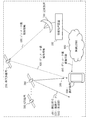
- FIG. 3 is a diagram illustrating a configuration example of a positioning system according to the first embodiment.
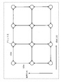
- FIG. 4 shows grid points according to the first embodiment.
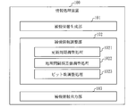
- 2 is a diagram illustrating a configuration example of an information processing device according to Embodiment 1.
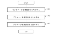
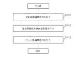
- FIG. 3 is a flowchart showing an operation example of the information processing apparatus according to the first embodiment. The flowchart figure which shows the example of the production
- FIG. FIG. 6 is a diagram illustrating an example of an update cycle adjustment process according to the first embodiment.
- FIG. 5 is a diagram showing an example of geographic interval error value adjustment processing according to the first embodiment.
- FIG. 6 is a diagram illustrating an example of bit number adjustment processing according to the first embodiment.
- FIG. 6 shows a configuration example of a positioning apparatus according to Embodiment 3.
- FIG. 6 illustrates components of a positioning device according to Embodiment 3.
- FIG. 6 is a diagram for explaining intermediate data of a positioning apparatus according to a third embodiment.
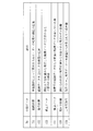
- FIG. 10 is a diagram illustrating an example of a threshold value table according to the third embodiment.
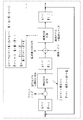
- FIG. 10 is a diagram showing a process flow of a Kalman filter according to the third embodiment.
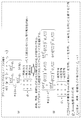
- FIG. 10 is a diagram for explaining vectors and matrices used in the Kalman filter according to the third embodiment.
- FIG. 10 is a diagram for explaining an operation example of a process noise adjustment unit according to the third embodiment.
- FIG. 10 is a diagram for explaining an operation example of an observation noise calculation unit according to the third embodiment.
- FIG. 10 is a diagram for explaining an operation example of an observation update calculation unit according to the fourth embodiment.
- FIG. 4 is a diagram illustrating an example of a hardware configuration of an information processing device and a positioning device according to Embodiments 1 to 4.
- FIG. 1 is a diagram illustrating a configuration example of a positioning system according to the present embodiment.
- the information processing apparatus 100 generates centimeter class reinforcement information, and degrades the generated centimeter class reinforcement information to generate decimator class reinforcement information. Then, the information processing apparatus 100 provides decimator class reinforcement information to the quasi-zenith satellite 200 and the wireless LAN network 800 described later.
- the centimeter class augmentation information is information for correcting a positioning error caused by independent positioning using a positioning signal from a GPS satellite, and a centimeter class positioning accuracy is realized as a corrected positioning accuracy. Reinforcement information.
- the centimeter-class positioning accuracy means that it is within a positioning error of the order of 2 to 3 centimeters with a probability of 65% or more.
- the decimator class reinforcement information is information for correcting a positioning error caused by independent positioning using a positioning signal from a GPS satellite, and the reinforcement information that realizes the decimator class positioning accuracy as the corrected positioning accuracy. It is.
- Decimator-class positioning accuracy means that a positioning error of the order of 20 to 30 centimeters is within a probability of 65% or more.
- the quasi-zenith satellite 200 receives the decimator class reinforcement information 400 obtained by the information processing apparatus 100 from the transmission apparatus 700, and transmits the received decimator class reinforcement information toward the ground.
- the quasi-zenith satellite 200 transmits the decimator class reinforcement information 400 at any one of frequencies L1, L2, and L5.
- the decimator class reinforcement information 400 may be transmitted from a satellite other than the quasi-zenith satellite 200.
- the decimator class reinforcement information 400 may be transmitted from the wireless LAN network 800 that provides a wireless LAN environment.
- the GPS satellite 300 is a positioning satellite and transmits a positioning signal 500.
- GNSS satellites such as GLONASS, Galileo, and BeiDou may be used.
- the decimator class reinforcement information 400 may be transmitted from the GPS satellite 300.
- the positioning signal 500 includes observation data 501 and a broadcast calendar 502. From the observation data 501, the pseudo distance between the positioning point and the GPS satellite 300 and the carrier phase can be derived. Each of the pseudorange and the carrier wave phase derived from the observation data 501 includes an error.
- the positioning device 600 uses the decimator class reinforcement information 400 to remove errors included in the pseudorange and the carrier phase.
- the broadcast calendar 502 is data in which an accurate satellite orbit of the GPS satellite 300 that is the transmission source of the broadcast calendar 502 is notified, and is also referred to as an ephemeris.
- the positioning device 600 is, for example, a smartphone, a mobile phone, a tablet terminal, or a car navigation device.
- Positioning device 600 receives positioning signal 500 transmitted from GPS satellite 300.
- the positioning device 600 also receives decimator class reinforcement information 400 transmitted from the quasi-zenith satellite 200 or the wireless LAN network 800.
- the positioning device 600 needs to support one of the frequencies L1, L2, and L5.
- the positioning device 600 can obtain the positioning result of the positioning accuracy of the decimator class by applying the decimator class reinforcement information 400 to the positioning signal 500 (including the positioning error of the meter class).
- the transmitting device 700 transmits the decimator class reinforcement information 400 generated by the information processing device 100 to the quasi-zenith satellite 200.
- the centimeter class reinforcement information includes satellite clock error values (hereinafter simply referred to as satellite clock errors), satellite orbit error values (hereinafter simply referred to as satellite orbit errors), frequency-to-frequency bias, ionospheric delay error values (hereinafter referred to as The value of the tropospheric delay error (hereinafter simply referred to as the tropospheric delay error).
- the satellite clock error, satellite orbit error, and inter-frequency bias are errors that do not depend on the region.
- the ionospheric delay error and tropospheric delay error are region-dependent errors and are calculated for each grid point. As shown in FIG.
- the grid points are virtual measurement points arranged at intervals of about 60 km in each of the latitude direction and the longitude direction.
- the ionospheric delay error and the tropospheric delay error correspond to the geographical interval error value described later.
- the centimeter class reinforcement information has a predetermined update cycle (specifically, satellite clock error is a cycle of 5 seconds, other satellite orbit errors, bias between frequencies, ionosphere delay error, troposphere delay error is a cycle of 30 seconds). Updated.
- FIG. 3 shows a configuration example of the information processing apparatus 100 according to the present embodiment.
- the reinforcement information generation unit 101 generates centimeter class reinforcement information.
- the generation method of the centimeter class reinforcement information by the reinforcement information generation unit 101 may be arbitrary.
- the reinforcement information adjustment unit 102 reduces the information amount of the centimeter class reinforcement information generated by the reinforcement information generation unit 101 and generates decimator class reinforcement information. More specifically, the reinforcement information adjustment unit 102 combines the update cycle adjustment process 1021, the geographic interval error value adjustment process 1022, and the bit number adjustment process 1023 to reduce the information amount of the centimeter class reinforcement information. .
- the update cycle adjustment process 1021 is a process of setting the update cycle of the centimeter class reinforcement information to an integral multiple of the predetermined update cycle. In the present embodiment, as an example of the update cycle adjustment process 1021, a process of setting the update cycle of the centimeter class reinforcement information to a 60-second cycle that is twice the original 30-second cycle will be described.
- the update cycle of the centimeter class reinforcement information may be an integer multiple of 2 or more of the original update cycle, and may not be doubled.
- the geographic interval error value adjustment processing 1022 selects a geographic interval error value for each geographic interval that is an integer multiple of the predetermined geographic interval from a plurality of geographic interval error values that are errors for each predefined geographic interval, and selects a geographic interval. This is a process of thinning out the number of error values.
- the ionospheric delay error and the tropospheric delay error are extracted every 180 km, which is three times the grid point interval of 60 km in each of the latitude direction and the longitude direction, A process for thinning out the number of ionospheric delay errors and tropospheric delay errors will be described. Note that in the geo-interval error value adjustment processing 1022, the ionospheric delay error and the tropospheric delay error may be extracted for each geographical interval that is an integer multiple of 2 or more of the original grid point interval, and may not be three times.
- the bit number adjustment process 1023 is a process for reducing the number of bits of the error value for each error value.
- the number of bits after deletion is any bit number between 60% and 80% of the number of bits before deletion.
- a process for reducing the number of bits from the least significant bit will be described. Note that in the bit number adjustment processing 1023, it is only necessary to reduce the number of bits from the least significant bit so that the number of bits after deletion becomes smaller than the number of bits before deletion, not the number of bits between 60% and 80%. May be.
- the reinforcement information output unit 103 outputs decimator class reinforcement information, which is reinforcement information after the information amount is deleted, to the output destination.
- the output destination of the reinforcement information output unit 103 is, for example, the interface of the transmission device 700 or the interface of the wireless LAN network 800.
- FIG. 4 is a flowchart showing an operation example of the information processing apparatus 100 according to the present embodiment.
- the reinforcement information generation unit 101 generates centimeter class reinforcement information.
- the reinforcement information adjustment unit 102 degrades the centimeter class reinforcement information and generates decimator class reinforcement information.
- the reinforcement information output unit 103 outputs the decimator class reinforcement information generated by the reinforcement information adjustment unit 102 to the output destination.
- the output destination of the reinforcement information output unit 103 is, for example, the interface of the transmission device 700 or the interface of the wireless LAN network 800 as described above.
- FIG. 5 is a flowchart for explaining details of S102.
- the reinforcement information adjustment unit 102 performs an update cycle adjustment process. Details of the update cycle adjustment processing will be described with reference to FIG.
- FIG. 6A shows a data stream of centimeter class reinforcement information.
- the update period of the centimeter class reinforcement information is 30 seconds.
- centimeter class reinforcement information in units of 30 seconds is repeatedly generated and input to the reinforcement information adjustment unit 102.
- the reinforcement information adjustment unit 102 selects centimeter class reinforcement information in units of 60 seconds.
- the reinforcement information adjustment unit 102 performs a geographic interval error value adjustment process.
- the reinforcement information adjustment unit 102 performs a geographic interval error value adjustment process for each centimeter class reinforcement information selected in S1021. Details of the geographic interval error value adjustment processing will be described with reference to FIG.
- Each point in FIG. 7 represents a grid point.
- Each centimeter class reinforcement information selected in S1021 includes ionospheric delay errors and tropospheric delay errors at all grid points.
- the reinforcement information adjustment unit 102 performs ionosphere every three grid point intervals (180 km) in the latitude direction and the longitude direction from the ionosphere delay error and the troposphere delay error of all grid points included in the centimeter class reinforcement information.
- a delay error and a tropospheric delay error are selected, and the number of ionospheric delay errors and tropospheric delay errors are thinned out.
- the ionospheric delay error and the tropospheric delay error corresponding to the grid points that are blacked out in FIG. 7 are selected and subjected to the processing of S1023.
- the geographic interval error value adjustment processing (S1022) is performed by the method shown in FIG. 7, the numbers of ionospheric delay errors and tropospheric delay errors to be processed in S1023 are each 1/9. That is, 1/9 as a whole is obtained by multiplying 1/3 in the latitude direction and 1/3 in the longitude direction.
- symbol 702 of FIG. 7 represent the ionosphere delay error and troposphere delay error contained in centimeter class reinforcement information.
- the positioning apparatus 600 uses the ion interpolation delay error and the troposphere delay error (reference numerals 701 and 702) included in the centimeter class reinforcement information to linearly complement the ionosphere delay error and troposphere delay of the grid points not included in the centimeter class reinforcement information.
- Error estimation values can be calculated.
- there may be an error (symbol 705, 706) from the estimated value (symbol 703, 704).
- the reinforcement information adjustment unit 102 notifies the deterioration of reliability caused by an error (reference numerals 705 and 706) from the estimated values at grid points not included in such centimeter class reinforcement information in the integrity information described later. .
- the reinforcement information adjustment unit 102 performs the bit number adjustment processing. Details of the bit number adjustment processing will be described with reference to FIG.
- reference numeral 801 indicates a centimeter class error value
- reference numeral 802 indicates a decimator class error value.
- the centimeter class error value 801 is each error value included in the centimeter class reinforcement information.
- Decimator class error value 802 is an error value after the number of bits of centimeter class error value 801 is reduced.
- the reinforcement information adjustment unit 102 sets the bit number of the decimator class error value 802 between 60% to 80% of the bit number of the centimeter class error value 801 for each error value related to the carrier wave. The number of bits is reduced from the least significant bit (LSB) so as to be any number of bits.
- LSB least significant bit
- the reinforcement information adjustment unit 102 deletes the number of bits so that the decimator class error value 802 has a bit number between 12 bits and 16 bits.
- the reinforcement information adjustment unit 102 includes the satellite clock error, satellite orbit error, inter-frequency bias included in the centimeter class reinforcement information selected in S1021, and the ionospheric delay included in the centimeter class reinforcement information and selected in S1022.
- the number of bits of the error and the tropospheric delay error is reduced. Note that the reinforcement information adjustment unit 102 notifies the deterioration of reliability due to the deletion of the number of bits in the integrity information described later.
- the information amount of the centimeter class reinforcement information is deleted and becomes decimator class reinforcement information.
- the transmission of centimeter class reinforcement information requires a bandwidth of 2 Kbps, but the transmission of decimeter class reinforcement information requires a band of 250 bps level. In this way, the data amount can be reduced to about 1/8 by converting into decimator class reinforcement information.
- the reinforcement information adjustment unit 102 uses the reduced number of bits and the reduced grid point information, and the reinforcement information when the information amount is reduced from the reliability of the reinforcement information obtained by the centimeter-class reinforcement information. Can be calculated.
- the reinforcement information adjustment unit 102 calculates the root-square sum RSS (Root Sum) of the reliability of the centimeter-class reinforcement information, the decrease in reliability due to the bit reduction, and the decrease in reliability due to the reduction of the grid points. By taking (Square), the reliability of the decimator class reinforcement information can be obtained. That is, the reinforcement information adjustment unit 102 calculates the root-square sum RSS of the error 705 and the error 706 shown in FIG. 7, and calculates the root-square sum RSS of the error corresponding to the number of deleted bits shown in FIG.
- the reinforcement information adjustment part 102 includes this reliability in integrity information as integrity information.
- the reinforcement information adjustment unit 102 generates integrity information that notifies a decrease in the reliability of positioning accuracy due to the geographical interval error value adjustment process and the bit number adjustment process, and the generated integrity information is converted into decimator-class reinforcement information.
- the reinforcement information output unit 103 transmits the reinforcement information including the integrity information.
- the integrity information is indispensable for the user who uses the decimator-class reinforcement information to determine the reliability of the positioning result from the reinforcement information in real time, and for the control of the moving body.
- the centimeter class reinforcement information by making the centimeter class reinforcement information into decimator class reinforcement information, the data amount of the reinforcement information can be compressed to about 1/8, and the communication band can be effectively used. Can be used. Further, since the centimeter class reinforcement information needs to be transmitted at 2 Kbps, it is necessary to use the L6 frequency when transmitting from a quasi-ceiling satellite or the like. Since the decimator class reinforcement information can be transmitted at a level of 250 bps, the frequencies L1, L2, and L5 can be used even when transmitting from a quasi-ceiling satellite or the like. Smartphones, mobile phones, tablet terminals, and car navigation devices are generally compatible with L1, L2, and L5 frequencies, and these devices can be compared to a decimator class even without an L6 frequency circuit or the like. Highly accurate positioning can be realized.
- Embodiment 2 the method of thinning out the number of ionospheric delay errors and tropospheric delay errors has been described. In this embodiment, a method for generating decimator class reinforcement information without thinning out ionospheric delay errors and tropospheric delay errors will be described.
- the overall configuration of the positioning system is as shown in FIG. 1, and the internal configuration of the information processing apparatus 100 is also as shown in FIG.
- the operation of the reinforcement information adjustment unit 102 is different.
- the reinforcement information adjustment unit 102 is included in an approximate expression for analyzing a plurality of geographical interval error values and calculating an approximate value of the geographical interval error value as the geographical interval error value adjustment processing 1022.
- the coefficient value of the coefficient is calculated for each geographic interval, and the coefficient value for each geographic interval is included in the reinforcement information instead of a plurality of geographic interval error values.
- the reinforcement information adjustment unit 102 analyzes a plurality of ionosphere delay errors included in the centimeter class reinforcement information selected in S1021 of FIG. 5 and calculates an approximate value of the ionosphere delay error at each grid point. The coefficient value of the coefficient included in the approximate expression is calculated for each grid point. Further, the reinforcement information adjustment unit 102 analyzes a plurality of tropospheric delay errors included in the centimeter class reinforcement information selected in S1021, and calculates an approximate expression for calculating an approximate value of the tropospheric delay error at each grid point. The coefficient value of the included coefficient is calculated for each grid point.
- the reinforcement information adjustment unit 102 includes the calculated coefficient value for each grid point in the centimeter class reinforcement information selected in S1021 instead of the ionospheric delay error. Further, the reinforcement information adjustment unit 102 includes the calculated coefficient value for each grid point in the centimeter class reinforcement information selected in S1021 instead of the tropospheric delay error.
- S1021 is the same as that in the first embodiment.
- the reinforcement information adjustment unit 102 selects the centimeter class reinforcement information to be processed in S1022 from the centimeter class reinforcement information input from the reinforcement information generation unit 101.
- the reinforcement information adjustment unit 102 analyzes a plurality of ionosphere delay errors included in the centimeter class reinforcement information selected in S1021, and calculates an approximate expression for calculating an approximate value of the ionosphere delay error at each grid point. The coefficient value of the coefficient included in is calculated for each grid point. Further, the reinforcement information adjustment unit 102 analyzes a plurality of tropospheric delay errors included in the centimeter class reinforcement information selected in S1021, and calculates an approximate expression for calculating an approximate value of the tropospheric delay error at each grid point. The coefficient value of the included coefficient is calculated for each grid point.
- the reinforcement information adjustment part 102 selected the coefficient value for every calculated grid point instead of the ionosphere delay error for every grid point included in the centimeter class reinforcement information selected in S1021 in S1021. Include in centimeter class reinforcement information.
- the reinforcement information adjustment unit 102 uses the calculated coefficient value for each grid point instead of the tropospheric delay error for each grid point included in the centimeter class reinforcement information selected in S1021 as the centimeter selected in S1021. Include in meter class reinforcement information.
- the approximate expression of the electronic layer delay error and the approximate expression of the tropospheric delay error are notified to the positioning device 600 in advance, and the positioning device 600 is included in the decimator class reinforcement information 400 received from the quasi-zenith satellite 200 or the wireless LAN network 800. By applying the obtained coefficient value to the approximate expression, the approximate value of the electronic layer delay error and the approximate value of the tropospheric delay error at each grid point can be obtained.
- FIG. 9 is a diagram for explaining the operation of the reinforcement information adjustment unit 102 according to the present embodiment.
- each circle ( ⁇ ) represents an error value (ionosphere delay error, troposphere delay error) at each grid point.
- x indicates the latitude of the grid point position
- y indicates the longitude of the grid point position
- a, b, c, d, and e are coefficient values that the reinforcement information adjustment unit 102 calculates for each grid.
- F are constants.
- the reinforcement information adjustment unit 102 analyzes the error value for each grid point, and calculates the values of the coefficients a, b, c, d, e of the approximate expression by, for example, the least square method. Then, the reinforcement information adjustment unit 102 performs coefficients a, b, c, d, e for each grid point instead of the ionospheric delay error for each grid point included in the centimeter class reinforcement information selected in S1021. Is included in the centimeter class reinforcement information selected in S1021.
- the reinforcement information adjustment unit 102 performs coefficients a, b, c, d, e for each grid point instead of the tropospheric delay error for each grid point included in the centimeter class reinforcement information selected in S1021. Is included in the centimeter class reinforcement information selected in S1021.
- the positioning device 600 can calculate the estimated values of the ionospheric delay error and the tropospheric delay error for each grid point from the approximate expression, but the estimated value and the actual ionospheric delay error and tropospheric delay error are as shown in FIG. There is an error. In FIG. 9, for reasons of drawing, errors are specified only for a few grid points, but the deviation between the approximate expression graph and each circle is an error.
- the reinforcement information adjustment unit 102 notifies the deterioration of reliability due to the use of the approximate expression in the integrity information described later.
- the reinforcement information adjustment unit 102 reduces the number of bits for each error value included in the centimeter class reinforcement information after the process of S1022.
- the processing in S1023 is as described in the first embodiment. Note that the reinforcement information adjustment unit 102 does not reduce the number of bits for the coefficient values (values of coefficients a, b, c, d, and e) included in the centimeter class reinforcement information in S1022.
- the information amount of the centimeter class reinforcement information is deleted and becomes decimator class reinforcement information. Also by the method according to the present embodiment, the data amount can be reduced to about 1/8 compared to the centimeter class reinforcement information by converting into decimator class reinforcement information.
- the reinforcement information adjustment unit 102 uses the reduced number of bits and the approximate expression of the geographical interval error value to reinforce the information when the information amount is reduced from the reliability of the reinforcement information obtained with the centimeter-class reinforcement information.
- the reliability of information can be calculated.
- the reinforcement information adjustment unit 102 calculates the root-square sum RSS (Root Sum) of the reliability of the centimeter-class reinforcement information, the decrease in reliability due to the bit reduction, and the decrease in reliability due to the use of the approximate expression. By taking (Square), the reliability of the decimator class reinforcement information can be obtained. That is, the reinforcement information adjustment unit 102 calculates the root-square sum RSS of each error illustrated in FIG. 9 and calculates the root-square sum RSS of the error corresponding to the number of deleted bits illustrated in FIG.
- the reinforcement information adjustment part 102 includes this reliability in integrity information as integrity information.
- the reinforcement information adjustment unit 102 generates integrity information that notifies a decrease in the reliability of positioning accuracy due to the geographical interval error value adjustment process and the bit number adjustment process, and the generated integrity information is converted into decimator-class reinforcement information.
- the reinforcement information output unit 103 transmits the reinforcement information including the integrity information.
- This integrity information is indispensable information for the control of a moving body because it enables a user who uses decimator-class reinforcement information to obtain the reliability of the positioning result from the reinforcement information in real time.
- the centimeter class reinforcement information into the decimator class reinforcement information, the data amount of the reinforcement information can be compressed to about 1/8, and the communication band can be used effectively.
- a smartphone a mobile phone, a tablet terminal, a car navigation device, and the like, it is possible to realize a relatively highly accurate positioning such as a decimator class without using an L6 frequency circuit or the like.
- the decimator class reinforcement information generation processing is performed in the order of update cycle adjustment processing S1021, geographic interval error value adjustment processing S1022, and bit number adjustment processing S1023 in FIG.
- the update cycle adjustment processing S1021 may be performed after the geographical interval error value adjustment processing S1022, and the bit adjustment processing S1023 may be performed.
- Embodiment 3 details of the positioning device 600 shown in FIG. 1 will be described.
- the positioning device 600 receives the decimator class reinforcement information 400 and performs satellite positioning using the decimator class reinforcement information 400.
- the decimator class reinforcement information 400 is the centimeter class reinforcement information. If centimeter class reinforcement information is received, satellite positioning may be performed using the centimeter class reinforcement information.
- FIG. 10 shows a configuration example of the positioning apparatus 600 according to the present embodiment. Further, a schematic description of each component shown in FIG. 10 is shown in FIG. 11, and a schematic description of intermediate data is shown in FIG.
- the approximate position and satellite position calculation unit 601 receives the observation data 501 and the broadcast calendar 502 from the GPS satellite 300, and calculates the approximate position of the positioning point and the position of each GPS satellite 300.
- the calculation results of the approximate position and satellite position calculation unit 601 are the approximate position 751 and the satellite position 752.
- the approximate position 751 is a positioning point position with accuracy of the meter order calculated by single positioning.
- the satellite position 752 is the position of each GPS satellite 300 from which the positioning device 600 has received observation data.
- the correction data creation unit 602 receives the decimator class reinforcement information 400 from the quasi-zenith satellite 200, acquires the approximate position 751 and the satellite position 752, and corrects the correction data from the decimator class reinforcement information 400, the approximate position 751, and the satellite position 752. 753 is calculated.
- the correction data 753 indicates an error expected to be included in the observation data 501 received from each GPS satellite 300 at the positioning point.
- the observation data sorting unit 603 removes the observation data 501 that is predicted to have degraded quality. More specifically, the observation data selection unit 603 selects from among the plurality of observation data 501 based on the elevation angle of the GPS satellite 300 that is the positioning satellite from which the observation data 501 is transmitted and the received signal strength of the observation data 501. The observation data 501 used for positioning calculation is selected. For example, the observation data selection unit 603 includes a threshold table in which a plurality of elevation angle ranges are indicated and a threshold value of the received signal strength is defined for each elevation angle range.
- the observation data selection unit 603 refers to the threshold value table, and the received signal strength of the observation data 501 is equal to or greater than the threshold value of the received signal strength defined for the elevation angle range corresponding to the elevation angle of the GPS satellite 300 that is the transmission source. If so, the observation data 501 is selected.
- the observation data error correction unit 604 performs double difference calculation and outputs double difference data 754 of observation data.
- the double difference data 754 includes an amount obtained by subtracting the observation data of the primary satellite (observation data corrected using the correction data 753) from the observation data of the slave satellite (observation data corrected using the correction data 753). Indicated.
- the time extrapolation calculation unit 605 performs time extrapolation calculation to estimate the current epoch state quantity X (t) from the previous epoch state quantity X ⁇ (t ⁇ t). More specifically, the time extrapolation calculation unit 605 estimates the state quantity X (t) using the process noise adjusted by the process noise adjustment unit 611 described later. Note that the notation in which “ ⁇ ” is located immediately above “X” and the notation in which “ ⁇ ” is located in the upper right of “X” (“X ⁇ ”) shown in FIG. 10 have the same meaning. It is. “ ⁇ ” Means a state quantity after being updated by an observation update calculation unit 608 described later. The state quantity X (t) is the position and speed of the positioning device 600.
- the geometric distance calculation unit 606 calculates the geometric distance 755 from the satellite position 752 to the positioning point from the GPS satellite 300.
- the residual calculation unit 607 calculates a double difference residual 756 from the double difference data 754 and the geometric distance 755.
- the observation update calculation unit 608 updates the state quantity X (t) so that the estimation error of the state quantity X (t) is minimized. More specifically, the observation update calculation unit 608 updates the state quantity X (t) using the observation noise calculated by the observation noise calculation unit 612 described later.
- the state quantity X (t) after being updated by the observation update calculation unit 608 is expressed as a state quantity X ⁇ (t).
- the positioning calculation unit 609 performs positioning calculation using the process noise adjusted by the process noise adjustment unit 611 and the observation noise calculated by the observation noise calculation unit 612.
- the carrier smoothing processing unit 610 performs carrier smoothing processing on the observation data 501 (pseudorange and carrier phase).
- the process noise adjustment unit 611 determines the process noise used for the positioning calculation in the positioning calculation unit 609 (more specifically, the time extrapolation calculation unit 605) according to the type of the moving object in which the positioning device 600 is arranged. adjust. For example, the process noise adjustment unit 611 selects process noise in an altitude direction that is smaller than the default value if the moving body in which the positioning device 600 is arranged is any one of a vehicle, a train, and a ship.
- the observation noise calculation unit 612 calculates observation noise used for positioning calculation using the integrity information included in the reinforcement information.
- the integrity information is information for conveying the “probability” of the positioning signal, and is used when determining whether the positioning result can be used safely.
- the observation data selection unit 603 selects the observation data 501 to be processed after the observation data error correction unit 604 from the observation data 501 after the carrier smoothing processing is performed by the carrier smoothing processing unit 610. Based on the elevation angle of the GPS satellite 300 that is the transmission source of the observation data 501 and the received signal strength of the observation data 501, the observation data selection unit 603 performs processing subsequent to the observation data error correction unit 604 from among the plurality of observation data 501. The observation data 501 that is the target of the selection is selected. Until now, in the positioning device, the observation data used for the positioning calculation has been selected based on the received signal strength, and until now, it is common regardless of the elevation angle between the GPS satellite 300 and the positioning device. The received signal strength threshold was applied.
- the observation data selection unit 603 takes into account the correlation between the elevation angle between the positioning device 600 and the GPS satellite 300 and the received signal strength of the observation data, and the observation data 501 used for the positioning calculation. Select.
- the observation data sorting unit 603 holds, for example, a threshold table shown in FIG.
- the threshold value table of FIG. 13 shows a plurality of elevation angle ranges, and a threshold value of received signal strength is defined for each elevation angle range. That is, in FIG. 13, as the elevation angle range, for example, a range of 10 degrees to 20 degrees and a range of 20 degrees to 30 degrees are described. In FIG. 13, 10 degrees to 20 degrees means 10.1 degrees to 20.0 degrees, and 20 degrees to 30 degrees means 20.1 degrees to 30.0 degrees.
- the threshold table in FIG. 13 is generated by analyzing the correlation between the satellite elevation angle and the received signal strength of observation data for a plurality of GPS satellites 300.
- the observation data selection unit 603 calculates the satellite elevation angle of the GPS satellite 300 that is the transmission source of the observation data 501 from the satellite position 752 calculated by the approximate position and satellite position calculation unit 601. Then, the observation data selection unit 603 refers to the threshold value table of FIG. 13, and the received signal defined for the elevation angle range corresponding to the calculated satellite elevation angle among the plurality of observation data 501 after the carrier smoothing process. The observation data 501 of the received signal strength that is equal to or greater than the strength threshold is selected. The observation data selection unit 603 outputs only the selected observation data 501 to the observation data error correction unit 604. For the positioning calculation by the positioning calculation unit 609, the observation data selection unit 603 needs to select four or more observation data 501.
- FIG. 14 shows a process flow of the Kalman filter.
- FIG. 15 illustrates the variables used for the Kalman filter processing.
- the time extrapolation calculation unit 605 performs time extrapolation calculation of the Kalman filter shown in FIG.
- observation update calculation section 608 performs observation update calculation of the Kalman filter shown in FIG.
- One loop is constituted by the time extrapolation calculation and the observation update calculation, and a loop constituted by the time extrapolation calculation and the observation update calculation is repeatedly executed.
- the state quantity is estimated so as to be minimized.
- the state quantity at the next time is determined by the transition matrix ⁇ determined according to the motion model to be adopted from the state quantity at the previous time (x ⁇ (-)) and the error variance matrix (P ⁇ (-)). (X (+)) and the error covariance matrix (P (+)) are estimated.
- the process noise Q which is an expected error between the motion model and the actual phenomenon, is added to the error covariance matrix (P ⁇ (-)). This process noise Q is also determined by the motion model and design that employs it.
- the observation matrix used in the observation update calculation is a matrix expressing the observation model, and is obtained by the following equation.
- R included in the denominator in the Kalman gain K equation represents the observed noise expected to be included in the observed quantity.
- the process noise adjustment unit 611 adjusts the process noise provided to the time extrapolation calculation unit 605.
- FIG. 16 shows the default process noise and the process noise after adjustment by the process noise adjustment unit 611.
- the default process noise Q 3 are, as shown in FIG. 16 (a), X component (east-west direction), Y component (north-south direction), Z-component (altitude direction) there is no anisotropy equivalent to each other.
- X component east-west direction
- Y component noth-south direction
- Z-component altitude direction
- cars, trains, ships, etc. have a gradual change in the direction of altitude. For this reason, if the mobile body in which the positioning device 600 is arranged is a vehicle, a train, or a ship, it is desirable that the process noise in the altitude direction be smaller than the default value.
- the process noise adjustment unit 611 is configured so that the moving body is any one of a vehicle, a train, and a ship (when the positioning device 600 is mounted on any of the vehicle, the train, and the ship). , as the value of the advanced direction of the process noise, selecting f ⁇ a (0 ⁇ f ⁇ ⁇ 1) .
- the process noise adjuster 611 outputs the process noise Q ⁇ which contains f ⁇ time extrapolation calculation unit 605, a time extrapolation calculations shown in FIG. 14 using a time extrapolation calculation unit 605 Q ⁇ Do.
- the moving body in which the positioning device 600 is arranged is a user (human), that is, when the user is carrying the positioning device 600 and moving on foot (the positioning device 600 is a vehicle, train, ship).
- the process noise adjustment unit 611 outputs the default process noise Q 3 to the time extrapolation calculation unit 605, and the time extrapolation calculation unit 605 uses Q 3 for the out-of-time shown in FIG. Perform the interpolation calculation.
- the moving body in which positioning device 600 is arranged is an airplane, process noise adjustment unit 611 outputs default process noise Q 3 to time extrapolation calculation unit 605, and time extrapolation calculation unit 605 outputs Q 3.
- T cef nuu is a matrix for converting the ceef coordinate system into the enu coordinate system.
- Q 3 and Q ⁇ are matrixes (process noise) of the eu coordinate system, and f ⁇ is a value of process noise in the altitude direction when the moving body is any one of a vehicle, a train, and a ship.
- the observation noise calculation unit 612 calculates the observation noise provided to the observation update calculation unit 608.
- FIG. 17 shows conventional observation noise and observation noise by the observation noise calculator 612. As the elevation angle is lower, the satellite signal is more likely to be affected by obstacles such as buildings and mountains, and the distance that passes through the atmosphere and ionosphere that cause signal delay increases. ), The observation noise of the low elevation satellite signal is increased. Observation data from a satellite with a large observation noise value is set to a low weight in the observation update calculation in the observation update calculation unit 608, and as a result, the ratio reflected in the positioning result is low.
- the reinforcement information includes integrity information.
- a high value is set for observation data from a satellite considered to have low quality
- a low value is set for observation data from a satellite considered to have high quality.
- observation data from low elevation satellites is likely to be of low quality, and it is desirable that the observation data from low elevation satellites, which are considered to be of low quality, be reflected in the positioning results.
- the observation noise calculation unit 612 sets the observation noise more appropriately by using the integrity information for the calculation of the observation noise. More specifically, as shown in FIG. 17B, the observation noise calculation unit 612 reflects the value of the integrity information of the target GPS satellite in the observation noise calculation formula.
- the observation noise calculation unit 612 outputs an observation noise R that is a matrix of the observation noise ⁇ i calculated by the equation shown in FIG. 17B to the observation update calculation unit 608, and the observation update calculation unit 608 uses the observation noise R.
- the observation update calculation shown in FIG. In FIG. 17, i is the satellite number, ⁇ i is the observation noise of satellite i, and ⁇ pr is a design constant. Further, n is the number of satellites captured by the positioning device 600, and el i is the elevation angle of the satellite i. I i is the integrity information of satellite i.
- the observation noise calculation unit 612 calculates the satellite elevation angle of the satellite i from the satellite position 752 calculated by the approximate position and satellite position calculation unit 601.
- the observation data selection unit 603 selects observation data to be used for positioning calculation in consideration of the satellite elevation angle, so that high-quality observation data can be selected more accurately.
- the process noise adjustment unit 611 selects process noise according to the type of moving body, it is possible to improve positioning accuracy by using process noise suitable for the type of moving body. it can.
- observation noise calculation unit 612 calculates observation noise using integrity information, weighting of high-quality observation data is weighted, and weighting of low-quality observation data is lightened. By doing so, positioning accuracy can be improved.
- Embodiment 4 FIG. In this embodiment, another form of the positioning device 600 will be described. *** Explanation of configuration *** Also in this embodiment, a configuration example of the positioning device 600 is as shown in FIG. However, in the present embodiment, the observation data selection unit 603 selects m (n (n ⁇ 5)) of the observation data of n when n (n ⁇ 5) observation data is selected based on the satellite elevation angle and the received signal strength. The operation of selecting m ⁇ 4 and m ⁇ n) observation data is repeated. The observation data selection unit 603 is k (k ⁇ 4 and k ⁇ n) data sets each composed of m observation data, and a combination of m observation data in each data set is obtained. Generate k different data sets.
- the observation update calculation unit 608 performs observation update calculation on m observation data constituting the data set for each data set, and observes each data set. Based on the variance value of the residual before the update calculation (double difference residual) and the variance value of the residual after the observation update calculation of each data set (double difference residual), among the k data sets Select one of the datasets. More specifically, the observation update calculation unit 608 extracts a data set having the smallest residual variance after the observation update calculation, and after the observation update calculation of the extracted extracted data set, The residual variance value after the update calculation of the data set with the second smallest variance value after the observation update calculation is compared.
- the observation update calculation unit 608 determines whether or not the variance value of the residual before the observation update calculation of the extracted data set is equal to or less than a threshold, and When the residual variance before the observation update calculation is equal to or less than the threshold value, the extracted data set is selected. Then, the observation update calculation unit 608 treats the residual (double difference residual) in the selected extracted data set as the state quantity X ⁇ (t).
- the operations of the process noise adjustment unit 611 and the observation noise calculation unit 612 are the same as those described in the third embodiment.
- the approximate position and satellite position calculation unit 601, the correction data creation unit 602, the observation data error correction unit 604, the time extrapolation calculation unit 605, the geometric distance calculation unit 606, and the residual calculation unit 607 In the present embodiment, four or more observation data selected by the observation data sorting unit 603 are processed, but in this embodiment, k data sets each consisting of m observation data are processed. And however, the approximate position and satellite position calculation unit 601, the correction data generation unit 602, the observation data error correction unit 604, the time extrapolation calculation unit 605, and the geometric distance calculation are performed except that k data sets are processed. Operations of unit 606 and residual calculation unit 607 are the same as those described in the third embodiment.
- the approximate position and satellite position calculation unit 601, the correction data creation unit 602, the observation data error correction unit 604, the time extrapolation calculation unit 605, the geometric distance calculation unit 606, and the residual calculation unit 607 correspond to each data set.
- the same processing as in the third embodiment is performed.
- FIG. 18 illustrates an example in which the observation data selection unit 603 selects six observation data from the six GPS satellites 300 based on the satellite elevation angle and the received signal strength.
- the observation data selection unit 603 selects five observation data from the six observation data and generates a data set.
- the data set generated first is referred to as data set # 1.
- the data set # 1 includes observation data of satellite 1, observation data of satellite 2, observation data of satellite 3, observation data of satellite 4, and observation data of satellite 5.
- the observation data selection unit 603 outputs the generated data set # 1 to the observation data error correction unit 604.
- the observation data error correction unit 604 generates double difference data 754 by performing double difference calculation on the data set # 1 as in the third embodiment. Also, the residual calculation unit 607 calculates a double difference residual 756 from the double difference data 754 generated from the data set # 1 and the geometric distance 755, as in the third embodiment. The observation update calculation unit 608 performs observation update calculation of the double difference residual 756 for the data set # 1. The observation update calculation unit 608 also calculates the variance of the double difference residual 756 before the observation update calculation for the data set # 1 and the variance of the double difference residual 756 after the observation update calculation for the data set # 1. calculate. This is the first loop processing.
- the observation data selection unit 603 selects five observation data in a combination different from the data set # 1 among the six observation data, and generates a new data set.
- the data set generated at the second loop is referred to as data set # 2.
- the data set # 2 includes observation data of satellite 1, observation data of satellite 2, observation data of satellite 3, observation data of satellite 4, and observation data of satellite 6.
- the same processing as that for the data set # 1 is performed for the data set # 2, and the observation update calculation unit 608 performs the variance of the double difference residual 756 before the observation update calculation for the data set # 2 and the data set.
- the variance of the double difference residual 756 after the observation update calculation for # 2 is calculated. This is the second processing of the loop.
- the third to sixth loop processing is performed in the same manner, the data set # 3 to data set # 6 are generated by the observation data selection unit 603, and the data set # 3 to data are generated by the observation update calculation unit 608.
- the variance of the double difference residual 756 before the observation update calculation and the variance of the double difference residual 756 after the observation update calculation are calculated.
- the data set # 5 and the data set # 6 are not shown because of the drawing space limitation, but the data set # 5 is the observation data of the satellite 1, the observation data of the satellite 3, and the observation of the satellite 4.
- Data set # 6 includes satellite 2 observation data, satellite 3 observation data, satellite 4 observation data, satellite 5 observation data, and satellite 6 observation data.
- the residual before observation update means a double difference residual before the observation update calculation by the observation update calculator 608, and the residual after observation update is the observation update by the observation update calculator 608. It means double difference residual after calculation.
- the variance of the residual in loop 1 is the variance of the residual in data set # 1. The same applies to the loop 2 and later.
- the observation update calculation unit 608 calculates the variance after the observation update. Extract the smallest data set and the data set with the second smallest variance. Here, it is assumed that the variance of data set # 2 is the smallest and the variance of data set # 3 is the second smallest. Observation update calculation section 608 determines whether there is a significant difference between the variance of data set # 2 and the variance of data set # 3.
- a threshold value (difference threshold value) for the variance difference is prepared, and if the difference between the variance of the data set # 2 and the variance of the data set # 3 exceeds the difference threshold value, the observation update calculation unit 608 May determine that there is a significant difference.
- the observation update calculation unit 608 determines whether or not the variance of the data set # 2 before the observation update is sufficiently small. judge.
- a threshold for dispersion before observation update is prepared, and the observation update calculation unit 608 observes if the variance before observation update of the data set # 2 is equal to or less than the dispersion threshold before observation update.
- the observation update calculation unit 608 selects the data set # 2, and uses the double difference residual 756 after the observation update of the data set # 2 as the state quantity X ⁇ ( t).
- the operation of the process noise adjustment unit 611 and the observation noise calculation unit 612 is the same as that of the third embodiment, but the operation of the process noise adjustment unit 611 and the observation noise calculation unit 612 is the same as that of the third embodiment. It does not have to be.
- the process noise adjuster 611 regardless of the type of a moving body positioning device 600 is disposed, so as to output a default process noise Q 3 shown in FIG. 16 (a) to the time extrapolation calculation unit 605 May be.
- the observation noise calculation unit 612 may calculate the observation noise ⁇ i using the formula shown in FIG. 17A without using the integrity information.
- the observation data selection unit 603 has selected the n observation data using the threshold value of the received signal strength for each satellite elevation angle as in the third embodiment. You may make it select n observation data using the threshold value of the uniform received signal strength which is not related.
- the positioning device 600 that receives the decimator class reinforcement information 400 may perform the same operation. . That is, in the positioning device that receives the centimeter class reinforcement information, the observation data used for the positioning calculation may be selected from the plurality of observation data based on the satellite elevation angle and the received signal strength of the observation data. Good. Further, the observation noise may be calculated using the integrity information included in the centimeter class reinforcement information. In the positioning device that receives the centimeter class reinforcement information, the process noise may be adjusted according to the type of the moving body.
- k data sets are generated from the n observation data, the variance value of the residual before the observation update calculation of each data set, and the observation of each data set
- One of the data sets may be selected from the k data sets based on the residual variance value after the update calculation.
- the positioning apparatus 600 receives the decimator class reinforcement information 400 from the quasi-zenith satellite 200.
- the decimator class reinforcement information 400 is received from a satellite other than the quasi-zenith satellite 200.
- it may be received from a wireless LAN network 800 that provides a wireless LAN environment.
- the positioning device 600 receives the decimator class reinforcement information 400 from a satellite other than the quasi-zenith satellite 200
- the positioning device 600 includes a receiver for receiving a signal from the satellite, and
- the decimator class reinforcement information 400 received by the receiver may be input to the correction data creation unit 602.
- positioning device 600 receives decimator class reinforcement information 400 from wireless LAN network 800
- positioning device 600 includes a wireless LAN receiver and corrects decimator class reinforcement information 400 received by the wireless LAN receiver. What is necessary is just to input into the data preparation part 602.
- the information processing apparatus 100 and the positioning apparatus 600 are computers, and each element of the information processing apparatus 100 and the positioning apparatus 600 can be realized by a program.
- an arithmetic device 901, an external storage device 902, a main storage device 903, a communication device 904, and an input / output device 905 are connected to the bus.
- the arithmetic device 901 is a CPU (Central Processing Unit) that executes a program.
- the external storage device 902 is, for example, a ROM (Read Only Memory), a flash memory, or a hard disk device.
- the main storage device 903 is a RAM (Random Access Memory).
- the communication device 904 receives observation data and a broadcast calendar from a GPS satellite, and also receives reinforcement information from a quasi-zenith satellite or a wireless LAN network.
- the communication device 904 includes an AD (analog-digital) conversion function.
- the input / output device 905 is, for example, a touch panel display device.
- the program is normally stored in the external storage device 902, and is loaded into the main storage device 903 and sequentially read into the arithmetic device 901 and executed.
- the program is a program that realizes the functions described as “units” shown in FIG. 3 and FIG.
- an operating system (OS) is also stored in the external storage device 902. At least a part of the OS is loaded into the main storage device 903, and the arithmetic device 901 executes the OS as shown in FIG. 3 and FIG. Executes the program that realizes the function of " ⁇ part".
- FIG. 19 is merely an example of the hardware configuration of the information processing device 100 and the positioning device 600, and the hardware configuration of the information processing device 100 and the positioning device 600 is limited to the configuration described in FIG. Alternatively, other configurations may be used.
- 100 information processing device 101 reinforcement information generation unit, 102 reinforcement information adjustment unit, 103 reinforcement information output unit, 200 quasi-zenith satellite, 300 GPS satellite, 400 decimator class reinforcement information, 500 positioning signal, 600 positioning device, 601 approximate position and Satellite position calculation unit, 602 correction data creation unit, 603 observation data selection unit, 604 observation data error correction unit, 605 time extrapolation calculation unit, 606 geometric distance calculation unit, 607 residual calculation unit, 608 observation update calculation unit, 609 Positioning calculation unit, 610 Carrier smoothing processing unit, 611 Process noise adjustment unit, 612 Observation noise calculation unit, 700 Transmission device, 800 Wireless LAN network, 1021 Update interval adjustment processing, 1022 Geographic interval error value adjustment processing, 1023 Bit number adjustment processing.
Landscapes
- Engineering & Computer Science (AREA)
- Radar, Positioning & Navigation (AREA)
- Remote Sensing (AREA)
- Computer Networks & Wireless Communication (AREA)
- Physics & Mathematics (AREA)
- General Physics & Mathematics (AREA)
- Computer Security & Cryptography (AREA)
- Position Fixing By Use Of Radio Waves (AREA)
- Data Exchanges In Wide-Area Networks (AREA)
- Navigation (AREA)
Abstract
Description
単独測位方式に対して、補強情報を利用した測位方式では、センチメータ級の高精度測位が実現される。
この測位方式では、正確な座標が既知である電子基準点等の観測データを用いて、測位衛星に起因する誤差や大気状態に起因する誤差が測位衛星ごとに推定され、誤差補正量が補強情報として測位装置に提供される。
補強情報は、例えば、準天頂衛星からの送信又は無線LAN(Local Area Network)通信網からの送信により測位装置に提供される。
測位装置では、単独測位の結果に補強情報の誤差補正量を用いた誤差補正を行うことで、センチメータ級の高精度測位を実現することができる。
補強情報を用いた高精度測位に関する技術として、例えば、特許文献1に記載の技術がある。
一方で、センチメータ級の補強情報の送信には、2kpbs(bits per second)もの通信帯域が必要である。
準天頂衛星又は無線LAN網からは補強情報以外にも様々なサービスに用いられる情報が送信されており、補強情報の送信によって他の情報の通信帯域を圧迫してしまうという課題がある。
既定の更新周期で更新され、複数の誤差値が含まれる、衛星測位誤差の補正のための補強情報の情報量を削減する補強情報調整部と、
前記補強情報調整部により情報量が削除された後の補強情報を出力先に出力する補強情報出力部とを有する情報処理装置であって、
前記補強情報調整部は、
前記補強情報の更新周期を前記既定の更新周期の2以上の整数倍にする更新周期調整処理と、
前記複数の誤差値のうち、既定の複数のグリッド点の地理間隔ごとの誤差である複数の地理間隔誤差値の中から、緯度方向及び経度方向の各々で、前記既定の地理間隔の2以上の整数倍の地理間隔ごとに地理間隔誤差値を選択して地理間隔誤差値の個数を間引く地理間隔誤差値調整処理と、
搬送波に関する誤差値ごとに、削除後のビット数が削除前のビット数より小さくなるように最下位ビットから誤差値のビット数を削減するビット数調整処理と
を組み合わせて、前記補強情報の情報量を削減する。
また、本発明では、高精度測位を実現できる補強情報を加工しているので、測位精度を比較的高く維持することができる。
***構成の説明***
図1は、本実施の形態に係る測位システムの構成例を示す図である。
そして、情報処理装置100は、デシメータ級補強情報を、後述する準天頂衛星200や無線LAN網800に提供する。
なお、センチメータ級補強情報とは、GPS衛星からの測位信号を用いた単独測位で生じる測位誤差を補正するための情報であり、補正後の測位精度としてセンチメータ級の測位精度が実現される補強情報である。
センチメータ級の測位精度とは、65%以上の確率で2~3センチメータ・オーダーの測位誤差に収まることを意味する。
また、デシメータ級補強情報とは、GPS衛星からの測位信号を用いた単独測位で生じる測位誤差を補正するための情報であり、補正後の測位精度としてデシメータ級の測位精度が実現される補強情報である。
デシメータ級の測位精度とは、65%以上の確率で20~30センチメータ・オーダーの測位誤差に収まることを意味する。
準天頂衛星200は、例えば、デシメータ級補強情報400をL1、L2、L5のいずれかの周波数で送信する。
なお、本実施の形態では、準天頂衛星200からデシメータ級補強情報400を送信する例を説明するが、デシメータ級補強情報400を準天頂衛星200以外の衛星から送信するようにしてもよい。また、デシメータ級補強情報400を無線LAN環境を提供する無線LAN網800から送信するようにしてもよい。
GPS衛星300の代わりに、GLONASS、Galileo、BeiDou等のGNSS衛星を用いてもよい。
また、GPS衛星300からデシメータ級補強情報400を送信するようにしてもよい。
観測データ501からは、測位点とGPS衛星300との間の疑似距離と、搬送波位相を導出することができる。
観測データ501から導出される疑似距離及び搬送波位相には、それぞれ誤差が含まれる。
測位装置600は、デシメータ級補強情報400を用いて、疑似距離及び搬送波位相に含まれる誤差を除去する。
放送暦502は、放送暦502の送信元のGPS衛星300の正確な衛星軌道が通知されるデータであり、エフェメリスともいう。
測位装置600は、GPS衛星300から送信される測位信号500を受信する。
また、測位装置600は、準天頂衛星200又は無線LAN網800から送信されるデシメータ級補強情報400を受信する。
測位装置600は、準天頂衛星200からデシメータ級補強情報400を受信する場合は、L1、L2、L5のいずれかの周波数に対応している必要がある。
測位装置600は、測位信号500(メートル級の測位誤差が含まれる)にデシメータ級補強情報400を適用して、デシメータ級の測位精度の測位結果を得ることができる。
センチメータ級補強情報には、衛星時計誤差の値(以下、単に衛星時計誤差という)、衛星軌道誤差の値(以下、単に衛星軌道誤差という)、周波数間バイアス、電離層遅延誤差の値(以下、単に電離層遅延誤差という)、対流圏遅延誤差の値(以下、単に対流圏遅延誤差という)が含まれる。
衛星時計誤差、衛星軌道誤差、周波数間バイアスは、地域に依存しない誤差である。
電離層遅延誤差と対流圏遅延誤差は、地域に依存する誤差であり、グリッド点ごとに算出される。
グリッド点は、図2に示すように、緯度方向及び経度方向のそれぞれに約60km間隔で配置された仮想的な計測点である。
電離層遅延誤差と対流圏遅延誤差は、後述する地理間隔誤差値に該当する。
なお、センチメータ級補強情報は、既定の更新周期(具体的には、衛星時計誤差は5秒周期、その他の衛星軌道誤差、周波数間バイアス、電離層遅延誤差、対流圏遅延誤差は30秒周期)で更新される。
補強情報生成部101によるセンチメータ級補強情報の生成方法は、任意のものでよい。
より具体的には、補強情報調整部102は、更新周期調整処理1021と、地理間隔誤差値調整処理1022と、ビット数調整処理1023とを組み合わせて、センチメータ級補強情報の情報量を削減する。
更新周期調整処理1021は、センチメータ級補強情報の更新周期を既定の更新周期の整数倍にする処理である。
本実施の形態では、更新周期調整処理1021の一例として、センチメータ級補強情報の更新周期を本来の30秒周期の2倍の60秒周期にする処理を説明する。なお、更新周期調整処理1021では、センチメータ級補強情報の更新周期を本来の更新周期の2以上の整数倍とすればよく、2倍でなくてもよい。
地理間隔誤差値調整処理1022は、既定の地理間隔ごとの誤差である複数の地理間隔誤差値の中から前記既定の地理間隔の整数倍の地理間隔ごとに地理間隔誤差値を選択して地理間隔誤差値の個数を間引く処理である。
本実施の形態では、地理間隔誤差値調整処理1022の一例として、緯度方向及び経度方向の各々でグリッド点間隔である60kmの3倍の180kmごとに電離層遅延誤差及び対流圏遅延誤差を抽出して、電離層遅延誤差及び対流圏遅延誤差の個数を間引く処理を説明する。なお、地理間隔誤差値調整処理1022では、本来のグリッド点間隔の2以上の整数倍の地理間隔ごとに電離層遅延誤差及び対流圏遅延誤差を抽出すればよく、3倍でなくてもよい。
ビット数調整処理1023は、誤差値ごとに、誤差値のビット数を削減する処理である。
本実施の形態では、ビット数調整処理1023の一例として、搬送波に関する誤差値ごとに、削除後のビット数が削除前のビット数の60%から80%の間のいずれかのビット数になるように最下位ビットからビット数を削減する処理を説明する。なお、ビット数調整処理1023では、削除後のビット数が削除前のビット数よりも小さくなるように最下位ビットからビット数を削減すればよく、60%から80%の間のビット数でなくてもよい。
補強情報出力部103の出力先は、例えば、送信装置700のインタフェースや無線LAN網800のインタフェースである。
次に、本実施の形態に係る情報処理装置100の動作例を説明する。
図4は、本実施の形態に係る情報処理装置100の動作例を示すフローチャート図である。
次に、S102において、補強情報調整部102がセンチメータ級補強情報をデグレードして、デシメータ級補強情報を生成する。
最後に、S103において、補強情報出力部103が、補強情報調整部102により生成されたデシメータ級補強情報を出力先に出力する。
補強情報出力部103の出力先は、前述したように、例えば、送信装置700のインタフェースや無線LAN網800のインタフェースである。
図5は、S102の詳細を説明するフローチャート図である。
更新周期調整処理の詳細を、図6を参照して説明する。
図6(a)に示すように、センチメータ級補強情報の更新周期は30秒である。
補強情報(t=0)は、準天頂衛星200又は無線LAN網800において、時刻t=0から時刻t=30の間に送信されるセンチメータ級補強情報である。
補強情報(t=30)は、準天頂衛星200又は無線LAN網800において、時刻t=30から時刻t=60の間に送信されるセンチメータ級補強情報である。
時刻t=60以降についても同様である。
時刻t=0から時刻t=30までの30秒間では、計測タイミングT0(T0<(t=0))における、衛星時計誤差、衛星軌道誤差、周波数間バイアス、各グリッド点の電離層遅延誤差、各グリッド点の対流圏遅延誤差が、補強情報(t=0)として送信される。
次に、時刻t=30から時刻t=60までの30秒間では、新たな計測タイミングT1(T1<(t=30))における、衛星時計誤差、衛星軌道誤差、周波数間バイアス、各グリッド点の電離層遅延誤差、各グリッド点の対流圏遅延誤差が補強情報(t=30)として送信される。
時刻t=60以降についても同様である。
なお、厳密には、衛星時刻誤差は、5秒ごとに更新されるので、30秒の間に、衛星時計誤差は5回送信されるが、補強情報全体としては、30秒周期で更新されている。
補強情報調整部102は、図6(b)に示すように、60秒単位でセンチメータ級補強情報を選択する。
図6(b)の例では、補強情報調整部102は、時刻t=0から時刻t=30の間の補強情報(t=0)を選択し、補強情報(t=0)を60秒かけて送信する。
つまり、補強情報調整部102は、補強情報(t=0)を、図6(a)の送信レートの1/2のレートで送信する。
補強情報調整部102は、次の時刻t=30から時刻t=60の間の補強情報(t=30)は選択しない。
また、補強情報調整部102は、時刻t=60から時刻t=90の間の補強情報(t=60)を選択し、補強情報(t=60)を60秒かけて送信する。
つまり、補強情報調整部102は、補強情報(t=60)を、図6(a)の送信レートの1/2のレートで送信する。
補強情報調整部102は、次の時刻t=90から時刻t=120の間の補強情報(t=90)は選択しない。
更新周期調整処理(S1021)で選択されたセンチメータ級補強情報のみがS1022以降の処理の対象となる。
図6(b)に示す方式で更新周期調整処理(S1021)が行われると、S1022の処理の対象となるセンチメータ級補強情報の個数は半減する。
補強情報調整部102は、S1021で選択されたセンチメータ級補強情報ごとに地理間隔誤差値調整処理を行う。
地理間隔誤差値調整処理の詳細を、図7を参照して説明する。
S1021で選択された各センチメータ級補強情報には、全グリッド点の電離層遅延誤差、対流圏遅延誤差が含まれている。
S1022では、補強情報調整部102は、センチメータ級補強情報に含まれる全グリッド点の電離層遅延誤差、対流圏遅延誤差の中から、緯度方向及び経度方向において、3グリッド点間隔(180km)ごとに電離層遅延誤差、対流圏遅延誤差を選択して、電離層遅延誤差及び対流圏遅延誤差の個数を間引く。
間引いた結果、図7で黒く塗りつぶしているグリッド点に対応する電離層遅延誤差及び対流圏遅延誤差のみが選択され、S1023の処理の対象となる。
図7に示す方式で地理間隔誤差値調整処理(S1022)が行われると、S1023の処理の対象となる電離層遅延誤差及び対流圏遅延誤差の個数は、それぞれ1/9になる。
つまり、緯度方向の1/3、経度方向の1/3の乗算により、全体として1/9になる。
なお、図7の符号701及び符号702は、センチメータ級補強情報に含まれる電離層遅延誤差及び対流圏遅延誤差を表す。
測位装置600は、センチメータ級補強情報に含まれる電離層遅延誤差及び対流圏遅延誤差(符号701、符号702)の線形補完により、センチメータ級補強情報に含まれないグリッド点の電離層遅延誤差及び対流圏遅延誤差の推定値(符号703、符号704)を算出することができる。
しかしながら、現実の電離層遅延誤差及び対流圏遅延誤差では、推定値(符号703、符号704)からの誤差(符号705、符号706)が存在する可能性がある。
補強情報調整部102は、このようなセンチメータ級補強情報に含まれていないグリッド点における推定値との誤差(符号705、符号706)によって生じる信頼度の低下を、後述するインテグリティ情報において通知する。
ビット数調整処理の詳細を、図8を参照して説明する。
センチメータ級誤差値801は、センチメータ級補強情報に含まれる各誤差値である。
デシメータ級誤差値802は、センチメータ級誤差値801のビット数を削減した後の誤差値である。
ビット数調整処理(S1023)では、補強情報調整部102は、搬送波に関する誤差値ごとに、デシメータ級誤差値802のビット数がセンチメータ級誤差値801のビット数の60%から80%の間のいずれかのビット数になるように最下位ビット(LSB:Least Significant Bit)からビット数を削減する。
例えば、センチメータ級誤差値801が20ビットであれば、補強情報調整部102は、デシメータ級誤差値802のビット数が12ビット~16ビットの間のいずれかになるようにビット数を削除する。
補強情報調整部102は、S1021で選択されたセンチメータ級補強情報に含まれる衛星時計誤差、衛星軌道誤差、周波数間バイアスと、当該センチメータ級補強情報に含まれ、S1022で選択された電離層遅延誤差及び対流圏遅延誤差(図7の黒く塗りつぶしているグリッド点に対応する電離層遅延誤差及び対流圏遅延誤差)のビット数を削減する。
なお、補強情報調整部102は、ビット数を削除したことによる信頼性の低下を、後述するインテグリティ情報において通知する。
センチメータ級補強情報の送信には2Kbpsの帯域が必要であるが、デシメータ級補強情報の送信では250bpsレベルの帯域で足りる。
このように、デシメータ級補強情報に変換することで、1/8程度のデータ量にすることができる。
補強情報調整部102は、センチメータ級の補強情報の信頼性と、ビット削減による信頼性の低下分と、グリッド点を削減したことによる信頼性の低下分との根2乗和RSS(Root Sum Square)を取ることにより、デシメータ級の補強情報の信頼度を求めることができる。
つまり、補強情報調整部102は、図7に示す誤差705と誤差706の根2乗和RSSを計算し、また、図8に示す削除したビット数分に相当する誤差の根2乗和RSSを計算して、デシメータ級の補強情報の信頼度を求める。
そして、補強情報調整部102は、この信頼度をインテグリティ情報として、補強情報に含める。
このように、補強情報調整部102は、地理間隔誤差値調整処理とビット数調整処理による測位精度の信頼度の低下を通知するインテグリティ情報を生成し、生成したインテグリティ情報をデシメータ級の補強情報に含める。
補強情報出力部103は、インテグリティ情報が含まれる補強情報を送信する。
このインテグリティ情報は、デシメータ級の補強情報を利用するユーザにとっては、補強情報から測位した結果の信頼度をリアルタイムに求めることが可能となり、移動体の制御には不可欠な情報である。
以上のように、本実施の形態によれば、センチメータ級補強情報をデシメータ級補強情報にすることで、補強情報のデータ量を1/8程度に圧縮することができ、通信帯域を有効に利用することができる。
また、センチメータ級補強情報は2Kbpsで送信する必要があるため、準天井衛星等から送信する際には、L6周波数を用いる必要がある。
デシメータ級補強情報では250bpsレベルでの送信が可能なので、準天井衛星等から送信する際にも、L1、L2、L5の周波数を利用することが可能である。
スマートフォン、携帯電話機、タブレット端末、カーナビゲーション装置では、L1、L2、L5周波数の対応機種が一般的になっており、これらの機器において、L6周波数用の回路等がなくても、デシメータ級という比較的高精度な測位を実現することができる。
実施の形態1では、電離層遅延誤差及び対流圏遅延誤差の数を間引きする方式を説明した。
本実施の形態では、電離層遅延誤差及び対流圏遅延誤差を間引きすることなく、デシメータ級補強情報を生成する方式を説明する。
本実施の形態においても、測位システムの全体構成は図1に示すとおりであり、また、情報処理装置100の内部構成も図3に示すとおりである。
但し、本実施の形態では、補強情報調整部102の動作が異なる。
本実施の形態では、補強情報調整部102は、地理間隔誤差値調整処理1022として、複数の地理間隔誤差値を解析して、地理間隔誤差値の近似値を算出するための近似式に含まれる係数の係数値を地理間隔ごとに算出し、複数の地理間隔誤差値に代えて地理間隔ごとの係数値を補強情報に含ませる。
つまり、補強情報調整部102は、図5のS1021で選択されたセンチメータ級補強情報に含まれる複数の電離層遅延誤差を解析し、各グリッド点での電離層遅延誤差の近似値を算出するための近似式に含まれる係数の係数値をグリッド点ごとに算出する。
また、補強情報調整部102は、S1021で選択されたセンチメータ級補強情報に含まれる複数の対流圏遅延誤差を解析し、各グリッド点での対流圏遅延誤差の近似値を算出するための近似式に含まれる係数の係数値をグリッド点ごとに算出する。
そして、補強情報調整部102は、電離層遅延誤差の代わりに、算出したグリッド点ごとの係数値を、S1021で選択されたセンチメータ級補強情報に含める。
また、補強情報調整部102は、対流圏遅延誤差の代わりに、算出したグリッド点ごとの係数値を、S1021で選択されたセンチメータ級補強情報に含める。
以下で説明していない事項は、実施の形態1と同様である。
本実施の形態においても、情報処理装置100の動作は、以下に示す点を除き図4及び図5に示すとおりである。
本実施の形態では、図5のS1022の処理が異なる。
図5を参照して、本実施の形態に係る補強情報調整部102の動作を説明する。
つまり、補強情報調整部102は、図6に例示するように、補強情報生成部101から入力されたセンチメータ級補強情報からS1022の処理の対象となるセンチメータ級補強情報を選択する。
また、補強情報調整部102は、S1021で選択されたセンチメータ級補強情報に含まれる複数の対流圏遅延誤差を解析し、各グリッド点での対流圏遅延誤差の近似値を算出するための近似式に含まれる係数の係数値をグリッド点ごとに算出する。
そして、補強情報調整部102は、S1021で選択されたセンチメータ級補強情報に含まれているグリッド点ごとの電離層遅延誤差の代わりに、算出したグリッド点ごとの係数値を、S1021で選択されたセンチメータ級補強情報に含める。
また、補強情報調整部102はS1021で選択されたセンチメータ級補強情報に含まれているグリッド点ごとの対流圏遅延誤差の代わりに、算出したグリッド点ごとの係数値を、S1021で選択されたセンチメータ級補強情報に含める。
電子層遅延誤差の近似式及び対流圏遅延誤差の近似式は、予め測位装置600に通知されており、測位装置600は、準天頂衛星200又は無線LAN網800から受信したデシメータ級補強情報400に含まれる係数値を近似式に適用して、各グリッド点における電子層遅延誤差の近似値及び対流圏遅延誤差の近似値を得ることができる。
図9において、各円(○)は、各グリッド点における誤差値(電離層遅延誤差、対流圏遅延誤差)を表している。
測位装置600は、近似式:(x、y)=ax2+by2+cx+dy+exy+fを用いて、各グリッド点の誤差値の近似値を算出することができる。
当該近似式において、xはグリッド点位置の緯度を示し、yはグリッド点位置の経度を示し、a、b、c、d、eは補強情報調整部102がグリッドごとに算出する係数値であり、fは定数である。
なお、本近似式は、2次の多項式の場合の例を示すものであるが、近似式は2次に限定するものでない。
補強情報調整部102は、グリッド点ごとの誤差値を解析して、例えば最小二乗法により、近似式の係数a、b、c、d、eの値を算出する。
そして、補強情報調整部102は、S1021で選択されたセンチメータ級補強情報に含まれているグリッド点ごとの電離層遅延誤差の代わりに、グリッド点ごとに、係数a、b、c、d、eの値を、S1021で選択されたセンチメータ級補強情報に含める。
また、補強情報調整部102は、S1021で選択されたセンチメータ級補強情報に含まれているグリッド点ごとの対流圏遅延誤差の代わりに、グリッド点ごとに、係数a、b、c、d、eの値を、S1021で選択されたセンチメータ級補強情報に含める。
測位装置600は、近似式よりグリッド点ごとの電離層遅延誤差及び対流圏遅延誤差の推定値を算出することができるが、推定値と現実の電離層遅延誤差及び対流圏遅延誤差では、図9に示すように誤差が存在する。
図9では、作図上の理由から、数個のグリッド点についてのみ誤差を明記しているが、近似式のグラフと各円との乖離が誤差である。
補強情報調整部102は、近似式を用いることによる信頼性の低下を、後述するインテグリティ情報において通知する。
S1023の処理は、実施の形態1で示したとおりである。
なお、補強情報調整部102は、S1022においてセンチメータ級補強情報に含めた係数値(係数a、b、c、d、eの値)に対しては、ビット数の削減は行わない。
本実施の形態に係る方式によっても、デシメータ級補強情報に変換することで、センチメータ級補強情報に比べて、1/8程度のデータ量にすることができる。
補強情報調整部102は、センチメータ級の補強情報の信頼性と、ビット削減による信頼性の低下分と、近似式を用いたことによる信頼性の低下分との根2乗和RSS(Root Sum Square)を取ることにより、デシメータ級の補強情報の信頼度を求めることができる。
つまり、補強情報調整部102は、図9に示す各誤差の根2乗和RSSを計算し、また、図8に示す削除したビット数分に相当する誤差の根2乗和RSSを計算して、デシメータ級の補強情報の信頼度を求める。
そして、補強情報調整部102は、この信頼度をインテグリティ情報として、補強情報に含める。
このように、補強情報調整部102は、地理間隔誤差値調整処理とビット数調整処理による測位精度の信頼度の低下を通知するインテグリティ情報を生成し、生成したインテグリティ情報をデシメータ級の補強情報に含める。
補強情報出力部103は、インテグリティ情報が含まれる補強情報を送信する。
このインテグリティ情報は、デシメータ級の補強情報を利用するユーザにとっては、補強情報から測位した結果の信頼度をリアルタイムに求めることを可能にするため、移動体の制御には不可欠な情報である。
本実施の形態でも、センチメータ級補強情報をデシメータ級補強情報にすることで、補強情報のデータ量を1/8程度に圧縮することができ、通信帯域を有効に利用することができる。
また、スマートフォン、携帯電話機、タブレット端末、カーナビゲーション装置等において、L6周波数用の回路等がなくても、デシメータ級という比較的高精度な測位を実現することができる。
本実施の形態では、図1に示す測位装置600の詳細を説明する。
なお、本実施の形態では、測位装置600はデシメータ級補強情報400を受信し、デシメータ級補強情報400を用いて衛星測位を行う例を説明するが、デシメータ級補強情報400はセンチメータ級補強情報を受信可能であれば、センチメータ級補強情報を受信して、センチメータ級補強情報を用いて衛星測位を行うようにしてもよい。
***構成の説明***
図10は、本実施の形態に係る測位装置600の構成例を示す。
また、図10に示す各構成要素の概略説明を図11に示し、中間データの概略説明を図12に示す。
概略位置及び衛星位置計算部601の算出結果が、概略位置751と衛星位置752である。
概略位置751は、単独測位によって算出されたメートルオーダーの精度の測位点位置である。
衛星位置752は、測位装置600が観測データを受信した各GPS衛星300の位置である。
補正データ753には、測位点で各GPS衛星300から受信した観測データ501に含まれると予想される誤差が示される。
より具体的には、観測データ選別部603は、観測データ501の送信元の測位衛星であるGPS衛星300の仰角と観測データ501の受信信号強度とに基づいて、複数の観測データ501の中から、測位計算に用いられる観測データ501を選択する。
例えば、観測データ選別部603は、複数の仰角範囲が示され、仰角範囲ごとに、受信信号強度の閾値が定義されている閾値テーブルを有している。
そして、観測データ選別部603は、閾値テーブルを参照し、観測データ501の受信信号強度が、送信元のGPS衛星300の仰角に対応する仰角範囲に対して定義されている受信信号強度の閾値以上である場合に、当該観測データ501を選択する。
二重差データ754には、従衛星の観測データ(補正データ753を使って補正済みの観測データ)から主衛星の観測データ(補正データ753を使って補正済みの観測データ)を差し引いた量が示される。
より具体的には、時間外挿計算部605は、後述のプロセスノイズ調整部611により調整されたプロセスノイズを用いて、状態量X(t)を推定する。
なお、図10に示している「X」の真上に「^」が位置している表記と、「X」の右上に「^」が位置している表記(「X^」)は同じ意味である。
また、「^」は、後述する観測更新計算部608により更新された後の状態量であることを意味する。
なお、状態量X(t)は、測位装置600の位置及び速度である。
より具体的には、観測更新計算部608は、後述の観測ノイズ計算部612により算出された観測ノイズを用いて、状態量X(t)を更新する。
観測更新計算部608により更新された後の状態量X(t)を状態量X^(t)と表記する。
測位計算部609は、プロセスノイズ調整部611により調整されたプロセスノイズと観測ノイズ計算部612により算出された観測ノイズとを用いて、測位計算を行う。
例えば、プロセスノイズ調整部611は、測位装置600が配置されている移動体が車両、列車、船舶のいずれかであれば、デフォルト値よりも小さい高度方向のプロセスノイズを選択する。
インテグリティ情報とは、測位信号の「確からしさ」を伝えるための情報であり、測位結果を安全に利用できるかを判断する際に使用される。
本実施の形態では、主に、観測データ選別部603、時間外挿計算部605、観測更新計算部608、プロセスノイズ調整部611及び観測ノイズ計算部612の動作を説明する。
観測データ選別部603は、観測データ501の送信元のGPS衛星300の仰角と観測データ501の受信信号強度とに基づいて、複数の観測データ501の中から、観測データ誤差補正部604以降の処理の対象となる観測データ501を選択する。
これまでも測位装置において、測位計算に用いられる観測データを受信信号強度に基づいて選別することが行われており、これまではGPS衛星300と測位装置との間の仰角に関わりなく一律に共通の受信信号強度の閾値を適用していた。
衛星仰角と受信信号強度との間には相関があり、一般に、衛星仰角が大きくなれば、観測データの受信信号強度は強くなる。
例えば、あるGPS衛星300の観測データの受信信号強度が他のGPS衛星300が同等の仰角にある場合の受信信号強度に比べて大きく落ち込んでいる場合は、当該GPS衛星300の受信信号強度が一律の閾値を超えていても、当該GPS衛星300の観測データの品質はあまりよくないと推定される。
このため、本実施の形態では、観測データ選別部603は、測位装置600とGPS衛星300との間の仰角と観測データの受信信号強度の相関を参酌して、測位計算に用いられる観測データ501を選択する。
図13の閾値テーブルには、複数の仰角範囲が示され、仰角範囲ごとに、受信信号強度の閾値が定義されている。
すなわち、図13では、仰角範囲として、例えば、10度-20度の範囲、20度-30度の範囲が記述されている。
なお、図13の10度-20度とは、10.1度-20.0度を意味し、20度-30度とは、20.1度-30.0度を意味する。
図13の閾値テーブルは、複数のGPS衛星300について、衛星仰角と観測データの受信信号強度との相関を解析して生成されたものである。
観測データ選別部603は、概略位置及び衛星位置計算部601により計算された衛星位置752から、観測データ501の送信元のGPS衛星300の衛星仰角を算出する。
そして、観測データ選別部603は、図13の閾値テーブルを参照し、キャリアスムージング処理の後の複数の観測データ501のうち、算出した衛星仰角に対応する仰角範囲に対して定義されている受信信号強度の閾値以上の受信信号強度の観測データ501を選択する。
観測データ選別部603は、選択した観測データ501のみを観測データ誤差補正部604に出力する。
測位計算部609による測位計算のためには、観測データ選別部603は、観測データ501を4つ以上選択する必要がある。
図14は、カルマンフィルタの処理フローを示す。
また、図15は、カルマンフィルタの処理に用いられる変数の説明を示す。
また、観測更新計算部608では、図14に示すカルマンフィルタの観測更新計算が行われる。
時間外挿計算と観測更新計算で1つのループを構成し、時間外挿計算と観測更新計算で構成されるループが繰り返し実行される。
カルマンフィルタは、繰り返される各ループにおいて、推定する状態量(状態量X)の誤差分散(誤差分散行列Pij=E〈xixj〉、E〈a〉はaの分散)の対角成分が最小になるように状態量を推定する。
時間外挿計算では、前の時刻の状態量(x^(-))と誤差分散行列(P^(-))から、採用する運動モデルに従って決定される遷移行列Φによって次の時刻の状態量(x(+))と誤差共分散行列(P(+))が推定される。
この時、運動モデルと実際の現象との間の予想される誤差であるプロセスノイズQが誤差共分散行列(P^(-))に加算される。
このプロセスノイズQも採用する運動モデルと設計によって決定される。
推定された状態量(x(+))から、状態量と観測量の関係を表わす観測モデル(y―=f(x))により推定される観測量相当量y―が求められる(y―は、「y」の真上に「-」が位置していることを表す、以下も同様)。
観測更新計算では、実際の観測量との差である残差(dz=y-y―)が求められ、図14の式で表わされるカルマンゲインKを使用して残差が状態量の差に変換(dx=K・dz)され、状態量が更新される。
観測更新計算で使用される観測行列は観測モデルを表現した行列であり、次式で求められる。

図16は、デフォルトのプロセスノイズと、プロセスノイズ調整部611による調整後のプロセスノイズとを示す。
デフォルトのプロセスノイズQ3は、図16(a)に示すように、X成分(東西方向)、Y成分(南北方向)、Z成分(高度方向)は相互に同等で異方性がない。
しかしながら、車、列車、船舶などは、高度方向の変化の仕方が緩やかである。
このため、測位装置600が配置されている移動体が車両、列車、船舶であれば、高度方向のプロセスノイズは、デフォルト値より小さくすることが望ましい。
そこで、本実施の形態では、プロセスノイズ調整部611は、移動体が車両、列車、船舶のいずれかであれば(測位装置600が車両、列車、船舶のいずれかに搭載されている場合は)、高度方向のプロセスノイズの値として、f⊥(0<f⊥<<1)を選択する。
そして、プロセスノイズ調整部611は、f⊥が含まれるプロセスノイズQ⊥を時間外挿計算部605に出力し、時間外挿計算部605はQ⊥を用いて図14に示す時間外挿計算を行う。
一方、測位装置600が配置されている移動体がユーザ(人間)である場合、つまり、ユーザが測位装置600を携行して徒歩にて移動している場合(測位装置600が車両、列車、船舶に搭載されていない場合)は、プロセスノイズ調整部611はデフォルトのプロセスノイズQ3を時間外挿計算部605に出力し、時間外挿計算部605はQ3を用いて図14に示す時間外挿計算を行う。
また、測位装置600が配置されている移動体が飛行機であれば、プロセスノイズ調整部611はデフォルトのプロセスノイズQ3を時間外挿計算部605に出力し、時間外挿計算部605はQ3を用いて図14に示す時間外挿計算を行う。
なお、測位装置600が配置されている移動体の種別が、車両又は列車又は船舶であるのか、ユーザ(人間)又は飛行機であるのかは、例えば、ユーザが測位装置600に移動体の種別を入力するようにする。
また、図16において、Tecef enuはecef座標系をenu座標系に変換する行列である。
また、Q3及びQ⊥は、enu座標系の行列(プロセスノイズ)であり、f⊥は、移動体が車両、列車、船舶のいずれかである場合の高度方向のプロセスノイズの値である。
図17は、従来の観測ノイズと、観測ノイズ計算部612による観測ノイズとを示す。
仰角が低いほどビルや山などの障害物の影響を衛星信号が受ける可能性が高く、また、信号遅延の原因となる大気や電離層を通過する距離も長くなるため、従来は、図17(a)に示されるように、低仰角の衛星信号の観測ノイズを大きくしている。
観測ノイズの値が大きい衛星からの観測データは、観測更新計算部608における観測更新計算において低い重みづけが設定され、結果として、測位結果に反映される割合が低くなる。
補強情報にはインテグリティ情報が含まれる。
インテグリティ情報では、品質が低いと考えられる衛星からの観測データに対して高い値が設定されており、品質が高いと考えられる衛星からの観測データに対して低い値が設定されている。
前述のように、低仰角の衛星からの観測データは品質が低い可能性が高く、品質が低いと考えられる低仰角の衛星からの観測データは測位結果に反映される割合を低くすることが望ましい。
本実施の形態に係る観測ノイズ計算部612は、観測ノイズの計算にインテグリティ情報を用いることで、観測ノイズをより適切に設定する。
より具体的には、観測ノイズ計算部612は、図17(b)に示すように、観測ノイズの計算式に、対象のGPS衛星のインテグリティ情報の値を反映させる。
観測ノイズ計算部612は、図17(b)に示す式で計算した観測ノイズσiの行列である観測ノイズRを観測更新計算部608に出力し、観測更新計算部608は観測ノイズRを用いて図14に示す観測更新計算を行う。
なお、図17において、iは衛星番号であり、σiは衛星iの観測ノイズであり、σprは設計定数である。
また、nは測位装置600が捕捉した衛星数であり、eliは衛星iの仰角である。
また、Iiは衛星iのインテグリティ情報である。
観測ノイズ計算部612は、概略位置及び衛星位置計算部601により計算された衛星位置752から、衛星iの衛星仰角を算出する。
以上、本実施の形態によれば、観測データ選別部603が衛星仰角を参酌して測位計算に用いる観測データを選択するため、品質のよい観測データをより正確に選択することができる。
また、本実施の形態によれば、プロセスノイズ調整部611が移動体の種別に応じたプロセスノイズを選択するため、移動体の種別に適したプロセスノイズを用いることで測位精度を向上させることができる。
また、本実施の形態によれば、観測ノイズ計算部612がインテグリティ情報を用いて観測ノイズを算出するため、高品質の観測データの重みづけを重くし、低品質の観測データの重みづけを軽くすることで測位精度を向上させることができる。
そして、これらの効果により、デシメータ級の補強情報を用いることによる測位精度の低下を補うことができる。
本実施の形態では、測位装置600の別の形態を説明する。
***構成の説明***
本実施の形態でも、測位装置600の構成例は図10に示す通りである。
但し、本実施の形態では、観測データ選別部603は、衛星仰角と受信信号強度とに基づいてn(n≧5)個の観測データを選択した場合に、nの観測データの中からm(m≧4かつm<n)個の観測データを選択する動作を繰り返す。そして、観測データ選別部603は、それぞれがm個の観測データで構成されるk(k≧4かつk≦n)個のデータセットであって、各データセットにおけるm個の観測データの組合せが異なるk個のデータセットを生成する。
また、本実施の形態では、測位計算部609において、観測更新計算部608が、データセットごとに、データセットを構成するm個の観測データに対して観測更新計算を行い、各データセットの観測更新計算前の残差(二重差残差)の分散値と、各データセットの観測更新計算後の残差(二重差残差)の分散値とに基づき、k個のデータセットの中からいずれかのデータセットを選択する。
より具体的には、観測更新計算部608は、観測更新計算後の残差の分散値が最小のデータセットを抽出し、抽出した抽出データセットの観測更新計算後の残差の分散値と、観測更新計算後の残差の分散値が二番目に小さいデータセットの更新計算後の残差の分散値とを比較する。
分散値間に有意な差異が存在する場合に、観測更新計算部608は、抽出データセットの観測更新計算前の残差の分散値が閾値以下であるか否かを判断し、抽出データセットの観測更新計算前の残差の分散値が閾値以下である場合に、抽出データセットを選択する。
そして、観測更新計算部608は、選択した抽出データセットにおける残差(二重差残差)を、状態量X^(t)として扱う。
プロセスノイズ調整部611及び観測ノイズ計算部612の動作は、実施の形態3に示したものと同じである。
また、実施の形態3では、概略位置及び衛星位置計算部601、補正データ作成部602、観測データ誤差補正部604、時間外挿計算部605、幾何学距離計算部606及び残差計算部607は、観測データ選別部603により選択された4つ以上の観測データを処理の対象としていたが、本実施の形態では、それぞれがm個の観測データで構成されるk個のデータセットを処理の対象とする。
但し、処理の対象がk個のデータセットとなった以外は、概略位置及び衛星位置計算部601、補正データ作成部602、観測データ誤差補正部604、時間外挿計算部605、幾何学距離計算部606及び残差計算部607の動作は、実施の形態3に示したものと同じである。
つまり、概略位置及び衛星位置計算部601、補正データ作成部602、観測データ誤差補正部604、時間外挿計算部605、幾何学距離計算部606及び残差計算部607は、各データセットに対して、実施の形態3と同じ処理を行う。
次に、図18を参照して、本実施の形態に係る測位装置600の動作例を説明する。
本実施の形態では、観測データ選別部603及び観測更新計算部608の動作が実施の形態3と異なっているので、ここでは、主に観測データ選別部603及び観測更新計算部608の動作例を説明する。
つまり、図18では、観測データ選別部603が、衛星仰角と受信信号強度に基づいて、6個のGPS衛星300からの6個の観測データを選択した場合を例としている。
観測データ選別部603は、6個の観測データのうち5個の観測データを選択してデータセットを生成する。
ここでは、最初に生成されたデータセットをデータセット#1と称する。
図18の例では、データセット#1は、衛星1の観測データ、衛星2の観測データ、衛星3の観測データ、衛星4の観測データ、衛星5の観測データで構成される。
観測データ選別部603は、生成したデータセット#1を観測データ誤差補正部604に出力する。
観測データ誤差補正部604は、データセット#1に対して、実施の形態3と同様に、二重差計算を行って二重差データ754を生成する。
また、残差計算部607は、データセット#1から生成された二重差データ754と幾何学距離755から、実施の形態3と同様に、二重差残差756を計算する。
観測更新計算部608は、データセット#1についての二重差残差756の観測更新計算を行う。
観測更新計算部608は、また、データセット#1についての観測更新計算前の二重差残差756の分散と、データセット#1についての観測更新計算後の二重差残差756の分散を算出する。
ここまでがループ1回目の処理である。
次に、ループ2回目の処理として、観測データ選別部603が6個の観測データのうちデータセット#1とは異なる組合せで5個の観測データを選択して新たなデータセットを生成する。
ここでは、ループ2回目に生成されたデータセットをデータセット#2と称する。
図18の例では、データセット#2は、衛星1の観測データ、衛星2の観測データ、衛星3の観測データ、衛星4の観測データ、衛星6の観測データで構成される。
データセット#2に対しても、データセット#1と同じ処理が行われ、観測更新計算部608では、データセット#2についての観測更新計算前の二重差残差756の分散と、データセット#2についての観測更新計算後の二重差残差756の分散を算出する。
ここまでがループ2回目の処理である。
以降、同様にして、ループ3回目~ループ6回目の処理が行われ、観測データ選別部603によりデータセット#3~データセット#6が生成され、観測更新計算部608によりデータセット#3~データセット#6の各々に対して、観測更新計算前の二重差残差756の分散と観測更新計算後の二重差残差756の分散が算出される。
図18では、作図スペースの制約から、データセット#5及びデータセット#6の図示を省略しているが、データセット#5は、衛星1の観測データ、衛星3の観測データ、衛星4の観測データ、衛星5の観測データ、衛星6の観測データで構成され、データセット#6は、衛星2の観測データ、衛星3の観測データ、衛星4の観測データ、衛星5の観測データ、衛星6の観測データで構成される。
また、図18において、観測更新前残差とは、観測更新計算部608による観測更新計算前の二重差残差を意味し、観測更新後残差とは、観測更新計算部608による観測更新計算後の二重差残差を意味する。
また、観測更新前残差及び観測更新後残差において、ループ1の残差の分散とは、データセット#1での残差の分散である。
ループ2以降についても同様である。
ここでは、データセット#2の分散が最小であり、データセット#3の分散が2番目に小さかったと仮定する。
観測更新計算部608は、データセット#2の分散とデータセット#3の分散との間に有意な差異が存在するか否かを判定する。
例えば、分散の差異についての閾値(差異閾値)を用意し、データセット#2の分散とデータセット#3の分散との間の差異が、差異閾値を超えている場合は、観測更新計算部608は、有意な差異が存在すると判定するようにしてもよい。
データセット#2の分散とデータセット#3の分散との間に有意な差異が存在する場合は、観測更新計算部608は、データセット#2の観測更新前の分散が十分小さいか否かを判定する。
例えば、観測更新前の分散についての閾値(観測更新前分散閾値)を用意し、観測更新計算部608は、データセット#2の観測更新前の分散が観測更新前分散閾値以下であれば、観測更新前の分散が十分小さいと判定する。
観測更新前の分散が十分小さい場合は、観測更新計算部608は、データセット#2を選択し、データセット#2の観測更新後の二重差残差756を図10の状態量X^(t)として扱う。
以上、本実施の形態により、より高精度の測位結果が得られる観測データの組合せを得ることができる。
つまり、プロセスノイズ調整部611は、測位装置600が配置されている移動体の種別に関わらず、図16(a)に示すデフォルトのプロセスノイズQ3を時間外挿計算部605に出力するようにしてもよい。
また、観測ノイズ計算部612は、インテグリティ情報を用いずに、図17(a)に示す式にて、観測ノイズσiを計算するようにしてもよい。
更には、以上では、観測データ選別部603は、実施の形態3と同様に、衛星仰角ごとの受信信号強度の閾値を用いてn個の観測データを選択することを説明したが、衛星仰角に関わらない一律の受信信号強度の閾値を用いてn個の観測データを選択するようにしてもよい。
すなわち、センチメータ級補強情報を受信する測位装置において、衛星仰角と観測データの受信信号強度とに基づいて、複数の観測データの中から、測位計算に用いられる観測データを選択するようにしてもよい。
また、センチメータ級補強情報に含まれるインテグリティ情報を用いて、観測ノイズを算出するようにしてもよい。
また、センチメータ級補強情報を受信する測位装置において、移動体の種別に応じてプロセスノイズを調整するようにしてもよい。
また、センチメータ級補強情報を受信する測位装置において、n個の観測データからk個のデータセットを生成し、各データセットの観測更新計算前の残差の分散値と、各データセットの観測更新計算後の残差の分散値とに基づき、k個のデータセットの中からいずれかのデータセットを選択するようにしてもよい。
具体的には、測位装置600がデシメータ級補強情報400を準天頂衛星200以外の衛星から受信する場合には、測位装置600が当該衛星からの信号を受信するための受信機を備えるとともに、当該受信機が受信したデシメータ級補強情報400を補正データ作成部602に入力すればよい。
また、測位装置600がデシメータ級補強情報400を無線LAN網800から受信する場合には、測位装置600が無線LAN受信機を備えるとともに、当該無線LAN受信機が受信したデシメータ級補強情報400を補正データ作成部602に入力すればよい。
情報処理装置100及び測位装置600はコンピュータであり、情報処理装置100及び測位装置600の各要素をプログラムで実現することができる。
情報処理装置100及び測位装置600のハードウェア構成としては、バスに、演算装置901、外部記憶装置902、主記憶装置903、通信装置904、入出力装置905が接続されている。
外部記憶装置902は、例えばROM(Read Only Memory)やフラッシュメモリ、ハードディスク装置である。
主記憶装置903は、RAM(Random Access Memory)である。
測位装置600では、通信装置904は、GPS衛星からの観測データ及び放送暦を受信し、また、準天頂衛星又は無線LAN網からの補強情報を受信する。
また、測位装置600では、通信装置904には、AD(アナログ-ディジタル)変換機能が含まれている。
入出力装置905は、例えばタッチパネル式のディスプレイ装置等である。
プログラムは、図3及び図10に示す「~部」として説明している機能を実現するプログラムである。
更に、外部記憶装置902にはオペレーティングシステム(OS)も記憶されており、OSの少なくとも一部が主記憶装置903にロードされ、演算装置901はOSを実行しながら、図3及び図10に示す「~部」の機能を実現するプログラムを実行する。
また、実施の形態1~4の説明において、「~の補正」、「~の生成」、「~の作成」、「~の計算」、「~の算出」、「~の調整」、「~の判断」、「~の判定」、「~の更新」、「~の推定」、「~の抽出」、「~の選択」、「~の受信」等として説明している処理の結果を示す情報やデータや信号値や変数値が主記憶装置903にファイルとして記憶されている。
あるいは、これらの実施の形態のうち、1つを部分的に実施しても構わない。
あるいは、これらの実施の形態のうち、2つ以上を部分的に組み合わせて実施しても構わない。
なお、本発明は、これらの実施の形態に限定されるものではなく、必要に応じて種々の変更が可能である。
Claims (15)
- 既定の更新周期で更新され、複数の誤差値が含まれる、衛星測位誤差の補正のための補強情報の情報量を削減する補強情報調整部と、
前記補強情報調整部により情報量が削除された後の補強情報を出力先に出力する補強情報出力部とを有する情報処理装置であって、
前記補強情報調整部は、
前記補強情報の更新周期を前記既定の更新周期の2以上の整数倍にする更新周期調整処理と、
前記複数の誤差値のうち、既定の複数のグリッド点の地理間隔ごとの誤差である複数の地理間隔誤差値の中から、緯度方向及び経度方向の各々で、前記既定の地理間隔の2以上の整数倍の地理間隔ごとに地理間隔誤差値を選択して地理間隔誤差値の個数を間引く地理間隔誤差値調整処理と、
搬送波に関する誤差値ごとに、削除後のビット数が削除前のビット数より小さくなるように最下位ビットから誤差値のビット数を削減するビット数調整処理と
を組み合わせて、前記補強情報の情報量を削減する情報処理装置。 - 前記補強情報調整部は、
前記更新周期調整処理として、
前記補強情報の更新周期を前記既定の更新周期の2倍にする処理を行い、
前記地理間隔誤差値調整処理として、
前記複数の地理間隔誤差値の中から緯度方向及び経度方向の各々で前記既定の地理間隔の3倍の地理間隔ごとに地理間隔誤差値を選択して地理間隔誤差値の個数を間引く処理を行い、
前記ビット数調整処理として、
搬送波に関する誤差値ごとに、削除後のビット数が削除前のビット数の60%から80%の間のいずれかのビット数になるように最下位ビットからビット数を削減する処理を行う請求項1に記載の情報処理装置。 - 前記補強情報調整部は、
前記地理間隔誤差値調整処理として、
複数の電離層遅延誤差値の中から、前記緯度方向及び前記経度方向の各々で、前記既定の地理間隔の3倍の地理間隔ごとに電離層遅延誤差値を選択して電離層遅延誤差値の個数を間引く処理と、
複数の対流圏遅延誤差値の中から、前記緯度方向及び前記経度方向の各々で、前記既定の地理間隔の3倍の地理間隔ごとに対流圏遅延誤差値を選択して対流圏誤差値の個数を間引く処理とを行う請求項1に記載の情報処理装置。 - 既定の更新周期で更新され、複数の誤差値が含まれる、衛星測位誤差の補正のための補強情報の情報量を削減する補強情報調整部と、
前記補強情報調整部により情報量が削除された後の補強情報を出力先に出力する補強情報出力部とを有する情報処理装置であって、
前記補強情報調整部は、
前記補強情報の更新周期を前記既定の更新周期の2以上の整数倍にする更新周期調整処理と、
前記複数の誤差値のうち、既定の複数のグリッド点の地理間隔ごとの誤差である複数の地理間隔誤差値を解析して、地理間隔誤差値の近似値を算出するための近似式に含まれる係数の係数値を地理間隔ごとに算出し、前記複数の地理間隔誤差値に代えて地理間隔ごとの係数値を前記補強情報に含ませる地理間隔誤差値調整処理と、
搬送波に関する誤差値ごとに、削除後のビット数が削除前のビット数より小さくなるように最下位ビットから誤差値のビット数を削減するビット数調整処理と
を組み合わせて、前記補強情報の情報量を削減する情報処理装置。 - 前記補強情報調整部は、
前記更新周期調整処理として、
前記補強情報の更新周期を前記既定の更新周期の2倍にする処理を行い、
前記ビット数調整処理として、
搬送波に関する誤差値ごとに、削除後のビット数が削除前のビット数の60%から80%の間のいずれかのビット数になるように最下位ビットからビット数を削減する処理を行う請求項4に記載の情報処理装置。 - 前記補強情報調整部は、
前記地理間隔誤差値調整処理として、
複数の電離層遅延誤差値を解析して、電離層遅延誤差値の近似値を算出するための近似式に含まれる係数の係数値を地理間隔ごとに算出し、前記複数の電離層遅延誤差値に代えて地理間隔ごとの係数値を前記補強情報に含ませる処理と、
複数の対流圏遅延誤差値を解析して、対流圏遅延誤差値の近似値を算出するための近似式に含まれる係数の係数値を地理間隔ごとに算出し、前記複数の対流圏遅延誤差値に代えて地理間隔ごとの係数値を前記補強情報に含ませる処理とを行う請求項3に記載の情報処理装置。 - 前記補強情報調整部は、
センチメータ級の測位誤差が実現される補強情報の情報量を削減して、デシメータ級の測位誤差が実現される補強情報に変換する請求項1又は4に記載の情報処理装置。 - 前記補強情報調整部は、
前記地理間隔誤差値調整処理と前記ビット数調整処理による測位精度の信頼度の低下を通知するインテグリティ情報を生成し、生成したインテグリティ情報を、情報量が削除された後の補強情報に含め、
前記補強情報出力部は、
前記インテグリティ情報が含まれる、情報量が削除された後の補強情報を前記出力先に出力する請求項1又は4に記載の情報処理装置。 - 衛星測位誤差の補正のための補強情報に含まれるインテグリティ情報を用いて、測位計算に用いられる観測ノイズを算出する観測ノイズ計算部と、
前記観測ノイズ計算部により算出された観測ノイズを用いて、測位計算を行う測位計算部とを有する測位装置。 - 前記測位装置は、更に、
前記測位装置が配置されている移動体の種別に応じて、前記測位計算部での測位計算に用いられるプロセスノイズを調整するプロセスノイズ調整部を有する請求項9に記載の測位装置。 - 前記プロセスノイズ調整部は、
前記移動体が車両、列車、船舶のいずれかであれば、デフォルト値よりも小さい高度方向のプロセスノイズを選択する請求項10に記載の測位装置。 - 前記測位装置は、更に、
測位衛星から送信されたn(n≧5)個の観測データの中からm(m≧4かつm<n)個の観測データを選択する動作を繰り返し、それぞれがm個の観測データで構成されるk(k≧4かつk≦n)個のデータセットであって、各データセットにおけるm個の観測データの組合せが異なるk個のデータセットを生成する観測データ選別部を有し、
前記測位計算部は、
前記測位計算の一部として、データセットごとに、データセットを構成するm個の観測データに対して観測更新計算を行い、各データセットの観測更新計算前の残差の分散値と、各データセットの観測更新計算後の残差の分散値とに基づき、前記k個のデータセットの中からいずれかのデータセットを選択する請求項9に記載の測位装置。 - 測位衛星から送信されたn(n≧5)個の観測データの中からm(m≧4かつm<n)個の観測データを選択する動作を繰り返し、それぞれがm個の観測データで構成されるk(k≧4かつk≦n)個のデータセットであって、各データセットにおけるm個の観測データの組合せが異なるk個のデータセットを生成する観測データ選別部と、
測位計算の一部として、データセットごとに、データセットを構成するm個の観測データに対して観測更新計算を行い、各データセットの観測更新計算前の残差の分散値と、各データセットの観測更新計算後の残差の分散値とに基づき、前記k個のデータセットの中からいずれかのデータセットを選択する測位計算部とを有する測位装置。 - 前記測位計算部は、
観測更新計算後の残差の分散値が最小のデータセットを抽出し、
抽出した抽出データセットの観測更新計算前の残差の分散値が閾値以下であるか否かを判断し、
前記抽出データセットの観測更新計算前の残差の分散値が閾値以下である場合に、前記抽出データセットを選択する請求項13に記載の測位装置。 - 前記測位計算部は、
前記抽出データセットの観測更新計算後の残差の分散値と、観測更新計算後の残差の分散値が二番目に小さいデータセットの更新計算後の残差の分散値とを比較し、
分散値間に有意な差異が存在する場合に、前記抽出データセットの観測更新計算前の残差の分散値が閾値以下であるか否かを判断する請求項14に記載の測位装置。
Priority Applications (8)
| Application Number | Priority Date | Filing Date | Title |
|---|---|---|---|
| EP17167756.0A EP3285091B1 (en) | 2014-10-30 | 2015-10-30 | Information processing device |
| EP15854727.3A EP3214464B1 (en) | 2014-10-30 | 2015-10-30 | Positioning device |
| AU2015337595A AU2015337595B2 (en) | 2014-10-30 | 2015-10-30 | Positioning Device |
| JP2016556649A JP6227163B2 (ja) | 2014-10-30 | 2015-10-30 | 測位装置 |
| US15/518,497 US10802152B2 (en) | 2014-10-30 | 2015-10-30 | Positioning device |
| EP18215394.0A EP3489720B1 (en) | 2014-10-30 | 2015-10-30 | Positioning device |
| AU2017202266A AU2017202266B2 (en) | 2014-10-30 | 2017-04-06 | Information processing device, information processing method, computer program, and computer-readable storage medium |
| US15/610,249 US10816669B2 (en) | 2014-10-30 | 2017-05-31 | Information processing device |
Applications Claiming Priority (2)
| Application Number | Priority Date | Filing Date | Title |
|---|---|---|---|
| JP2014-221755 | 2014-10-30 | ||
| JP2014221755 | 2014-10-30 |
Related Child Applications (2)
| Application Number | Title | Priority Date | Filing Date |
|---|---|---|---|
| US15/518,497 A-371-Of-International US10802152B2 (en) | 2014-10-30 | 2015-10-30 | Positioning device |
| US15/610,249 Continuation US10816669B2 (en) | 2014-10-30 | 2017-05-31 | Information processing device |
Publications (1)
| Publication Number | Publication Date |
|---|---|
| WO2016068275A1 true WO2016068275A1 (ja) | 2016-05-06 |
Family
ID=55857610
Family Applications (1)
| Application Number | Title | Priority Date | Filing Date |
|---|---|---|---|
| PCT/JP2015/080657 Ceased WO2016068275A1 (ja) | 2014-10-30 | 2015-10-30 | 情報処理装置及び測位装置 |
Country Status (7)
| Country | Link |
|---|---|
| US (2) | US10802152B2 (ja) |
| EP (3) | EP3285091B1 (ja) |
| JP (2) | JP6227163B2 (ja) |
| AU (2) | AU2015337595B2 (ja) |
| ES (1) | ES3010551T3 (ja) |
| MY (1) | MY168990A (ja) |
| WO (1) | WO2016068275A1 (ja) |
Cited By (3)
| Publication number | Priority date | Publication date | Assignee | Title |
|---|---|---|---|---|
| WO2017159579A1 (ja) * | 2016-03-14 | 2017-09-21 | ヤンマー株式会社 | 操船装置 |
| JPWO2018083803A1 (ja) * | 2016-11-07 | 2019-06-24 | 三菱電機株式会社 | 測位補強装置、測位補強システムおよび測位補強方法 |
| WO2022107453A1 (ja) * | 2020-11-18 | 2022-05-27 | 日本電信電話株式会社 | 衛星信号受信装置、衛星信号処理方法、及びプログラム |
Families Citing this family (3)
| Publication number | Priority date | Publication date | Assignee | Title |
|---|---|---|---|---|
| AU2014388689B2 (en) * | 2014-03-28 | 2017-10-19 | Mitsubishi Electric Corporation | Positioning device |
| SG11202007765SA (en) * | 2018-02-19 | 2020-09-29 | Mitsubishi Heavy Industries Machinery Systems Ltd | Positional error prediction device, prediction model generation device, positional error prediction method, prediction model generation method, and program |
| JP6952250B2 (ja) * | 2018-06-15 | 2021-10-20 | パナソニックIpマネジメント株式会社 | 測位方法および測位端末 |
Citations (7)
| Publication number | Priority date | Publication date | Assignee | Title |
|---|---|---|---|---|
| US6324473B1 (en) * | 1997-08-04 | 2001-11-27 | Trimble Navigation Limited | Method and apparatus for collecting, processing and distributing differential global positioning system information using the internet |
| JP2004138562A (ja) * | 2002-10-18 | 2004-05-13 | Matsushita Electric Works Ltd | Gps測位端末及びそれを用いる位置監視システム |
| JP2007093513A (ja) * | 2005-09-30 | 2007-04-12 | Mitsubishi Electric Corp | データ送信装置及びデータ送信方法及び測位装置 |
| JP2007171082A (ja) * | 2005-12-26 | 2007-07-05 | Nec Toshiba Space Systems Ltd | 電離層遅延補正方法、電離層遅延補正システム、地上局および移動局 |
| JP2008524596A (ja) * | 2004-12-16 | 2008-07-10 | レイセオン・カンパニー | ナビゲーションシステムの予想性能の決定 |
| JP2011179894A (ja) * | 2010-02-26 | 2011-09-15 | Furuno Electric Co Ltd | 測位方法、測位プログラム、gnss受信装置および移動端末 |
| JP2012085202A (ja) * | 2010-10-14 | 2012-04-26 | Honda Motor Co Ltd | 車両の位置情報を送受信可能な無線通信装置 |
Family Cites Families (45)
| Publication number | Priority date | Publication date | Assignee | Title |
|---|---|---|---|---|
| SK43793A3 (sk) * | 1991-09-12 | 1993-08-11 | Auspace Ltd | prijímač globálneho polohovacieho systému |
| US5365450A (en) * | 1992-12-17 | 1994-11-15 | Stanford Telecommunications, Inc. | Hybrid GPS/data line unit for rapid, precise, and robust position determination |
| US5323163A (en) | 1993-01-26 | 1994-06-21 | Maki Stanley C | All DOP GPS optimization |
| JP2861957B2 (ja) | 1996-07-31 | 1999-02-24 | トヨタ自動車株式会社 | 測位システム及びこのシステムに用いられる固定局側装置及び測位装置 |
| US6529830B1 (en) | 1997-08-04 | 2003-03-04 | Trimble Navigation Ltd. | Method and system for providing wide area augmentation systems (WAAS) like corrections using a server and processor on the internet |
| JP2000081476A (ja) | 1998-09-04 | 2000-03-21 | Hitachi Ltd | Gps装置 |
| JP3407705B2 (ja) | 1999-11-16 | 2003-05-19 | 日本電気株式会社 | 衛星航法受信システム及び監視装置 |
| US6834234B2 (en) | 2000-11-22 | 2004-12-21 | Trimble Navigation, Limited | AINS land surveyor system with reprocessing, AINS-LSSRP |
| US6429809B1 (en) * | 2001-01-30 | 2002-08-06 | Qualcomm Incorporated | Method and apparatus for determining location using a coarse position estimate |
| US6704652B2 (en) | 2001-10-29 | 2004-03-09 | Total Soft Bank Ltd. | Real time self differential global positioning system and method for a moving station in a local area, and terminal global positioning system using the same |
| JP3840972B2 (ja) | 2001-12-19 | 2006-11-01 | 三菱電機株式会社 | 準天頂衛星用車載器、準天頂衛星及び準天頂衛星システム |
| JP2003344524A (ja) | 2002-05-31 | 2003-12-03 | Matsushita Electric Works Ltd | 固定局とそれを用いたdgps測位システム |
| JP2004125667A (ja) | 2002-10-03 | 2004-04-22 | Matsushita Electric Ind Co Ltd | 測位装置 |
| JP2004251714A (ja) * | 2003-02-19 | 2004-09-09 | Mitsubishi Electric Corp | 測位装置 |
| JP2005024535A (ja) * | 2003-06-12 | 2005-01-27 | Mitsubishi Electric Corp | 位置推定装置 |
| JP4352954B2 (ja) * | 2004-03-17 | 2009-10-28 | 株式会社デンソー | 移動体用位置検出装置,測位結果評価方法及びコンピュータプログラム |
| JP2006125867A (ja) | 2004-10-26 | 2006-05-18 | Seiko Epson Corp | 測位システム、端末装置、情報提供装置、端末装置の制御方法、端末装置の制御プログラム |
| JP2006132949A (ja) | 2004-11-02 | 2006-05-25 | Seiko Epson Corp | 測位装置、測位方法および測位プログラム |
| US7978127B2 (en) * | 2007-02-26 | 2011-07-12 | Toyota Jidosha Kabushiki Kaisha | Mobile unit positioning device |
| WO2009000314A1 (en) * | 2007-06-22 | 2008-12-31 | Trimble Terrasat Gmbh | Position tracking device and method |
| JP5440894B2 (ja) | 2007-10-03 | 2014-03-12 | 測位衛星技術株式会社 | 位置情報提供システムおよび屋内送信機 |
| US8260551B2 (en) | 2008-01-10 | 2012-09-04 | Trimble Navigation Limited | System and method for refining a position estimate of a low earth orbiting satellite |
| WO2011126605A2 (en) | 2010-02-14 | 2011-10-13 | Trimble Navigation Limited | Gnss signal processing with regional augmentation network |
| JP5311865B2 (ja) | 2008-04-14 | 2013-10-09 | 三菱電機株式会社 | データ送信装置、データ送信方法、データ送信プログラム、測位装置、測位方法及び測位プログラム |
| US8134497B2 (en) | 2008-09-30 | 2012-03-13 | Trimble Navigation Limited | Method and system for location-dependent time-specific correction data |
| US20110032147A1 (en) | 2008-10-08 | 2011-02-10 | Venkatraman Sai | Providing ephemeris data and clock corrections to a satellite navigation system receiver |
| JP2010112725A (ja) | 2008-11-04 | 2010-05-20 | Mitsubishi Electric Corp | 補正データ送信装置、補正データ送信方法、補正データ送信プログラム、測位装置、測位方法および測位プログラム |
| US8416133B2 (en) * | 2009-10-15 | 2013-04-09 | Navcom Technology, Inc. | System and method for compensating for faulty measurements |
| US8400352B2 (en) | 2009-11-03 | 2013-03-19 | Novatel Inc. | Centimeter positioning using low cost single frequency GNSS receivers |
| JP5436170B2 (ja) | 2009-11-28 | 2014-03-05 | 三菱電機株式会社 | データ送信装置及びデータ送信方法 |
| JP5570649B2 (ja) | 2011-02-22 | 2014-08-13 | 三菱電機株式会社 | 測位補強情報生成装置、及び測位補強システム |
| WO2012128125A1 (ja) | 2011-03-23 | 2012-09-27 | 古野電気株式会社 | 測位装置、gnss受信機、情報端末機器、測位方法及びプログラム |
| WO2012130252A1 (en) | 2011-03-25 | 2012-10-04 | European Space Agency (Esa) | Method, apparatus and system for determining a position of an object having a global navigation satellite system receiver by processing undifferenced data like carrier phase measurements and external products like ionosphere data |
| JP2013083532A (ja) | 2011-10-07 | 2013-05-09 | Toyota Motor Corp | 位置情報検出装置および位置情報検出方法 |
| FR2981167B1 (fr) | 2011-10-07 | 2014-04-04 | Thales Sa | Systeme d'augmentation spatial adapte pour ameliorer la precision et la fiabilite des donnees delivrees par un systeme de navigation par satellites, et procede associe. |
| JP5667967B2 (ja) | 2011-12-20 | 2015-02-12 | 株式会社 日立産業制御ソリューションズ | 位置情報認証システムおよび位置情報認証方法 |
| US20140180580A1 (en) * | 2012-03-31 | 2014-06-26 | O2Micro Inc. | Module, device and method for positioning |
| JP6025430B2 (ja) | 2012-07-11 | 2016-11-16 | 三菱電機株式会社 | 送信装置 |
| JP2014037993A (ja) | 2012-08-13 | 2014-02-27 | Sharp Corp | 測位装置、測位方法、および測位プログラム |
| US9557419B2 (en) | 2012-12-18 | 2017-01-31 | Trimble Inc. | Methods for generating accuracy information on an ionosphere model for satellite navigation applications |
| US20150369924A1 (en) | 2013-02-04 | 2015-12-24 | Vanderbilt University | Method and system for high-accuracy differential tracking of global positioning system (gps) receivers |
| JP5895866B2 (ja) | 2013-02-05 | 2016-03-30 | 三菱電機株式会社 | Gnss測位装置およびgnss測位方法 |
| JP5983947B2 (ja) | 2013-04-15 | 2016-09-06 | 日本電気株式会社 | 測位端末、および精密単独測位方法 |
| CN104181561A (zh) | 2013-05-24 | 2014-12-03 | 凹凸电子(武汉)有限公司 | 一种接收机和卫星定位及测速方法 |
| JP6218445B2 (ja) | 2013-06-14 | 2017-10-25 | 三菱電機株式会社 | 測位補強装置及び測位補強システム及び測位補強方法 |
-
2015
- 2015-10-30 MY MYPI2017701274A patent/MY168990A/en unknown
- 2015-10-30 JP JP2016556649A patent/JP6227163B2/ja active Active
- 2015-10-30 ES ES18215394T patent/ES3010551T3/es active Active
- 2015-10-30 EP EP17167756.0A patent/EP3285091B1/en active Active
- 2015-10-30 WO PCT/JP2015/080657 patent/WO2016068275A1/ja not_active Ceased
- 2015-10-30 AU AU2015337595A patent/AU2015337595B2/en not_active Ceased
- 2015-10-30 US US15/518,497 patent/US10802152B2/en not_active Expired - Fee Related
- 2015-10-30 EP EP15854727.3A patent/EP3214464B1/en active Active
- 2015-10-30 EP EP18215394.0A patent/EP3489720B1/en active Active
-
2016
- 2016-10-05 JP JP2016197118A patent/JP6234528B2/ja active Active
-
2017
- 2017-04-06 AU AU2017202266A patent/AU2017202266B2/en not_active Ceased
- 2017-05-31 US US15/610,249 patent/US10816669B2/en not_active Expired - Fee Related
Patent Citations (7)
| Publication number | Priority date | Publication date | Assignee | Title |
|---|---|---|---|---|
| US6324473B1 (en) * | 1997-08-04 | 2001-11-27 | Trimble Navigation Limited | Method and apparatus for collecting, processing and distributing differential global positioning system information using the internet |
| JP2004138562A (ja) * | 2002-10-18 | 2004-05-13 | Matsushita Electric Works Ltd | Gps測位端末及びそれを用いる位置監視システム |
| JP2008524596A (ja) * | 2004-12-16 | 2008-07-10 | レイセオン・カンパニー | ナビゲーションシステムの予想性能の決定 |
| JP2007093513A (ja) * | 2005-09-30 | 2007-04-12 | Mitsubishi Electric Corp | データ送信装置及びデータ送信方法及び測位装置 |
| JP2007171082A (ja) * | 2005-12-26 | 2007-07-05 | Nec Toshiba Space Systems Ltd | 電離層遅延補正方法、電離層遅延補正システム、地上局および移動局 |
| JP2011179894A (ja) * | 2010-02-26 | 2011-09-15 | Furuno Electric Co Ltd | 測位方法、測位プログラム、gnss受信装置および移動端末 |
| JP2012085202A (ja) * | 2010-10-14 | 2012-04-26 | Honda Motor Co Ltd | 車両の位置情報を送受信可能な無線通信装置 |
Non-Patent Citations (1)
| Title |
|---|
| See also references of EP3214464A4 * |
Cited By (10)
| Publication number | Priority date | Publication date | Assignee | Title |
|---|---|---|---|---|
| WO2017159579A1 (ja) * | 2016-03-14 | 2017-09-21 | ヤンマー株式会社 | 操船装置 |
| JP2017165162A (ja) * | 2016-03-14 | 2017-09-21 | ヤンマー株式会社 | 操船装置 |
| US10976742B2 (en) | 2016-03-14 | 2021-04-13 | Yanmar Power Technology Co., Ltd. | Ship handling device |
| JPWO2018083803A1 (ja) * | 2016-11-07 | 2019-06-24 | 三菱電機株式会社 | 測位補強装置、測位補強システムおよび測位補強方法 |
| WO2022107453A1 (ja) * | 2020-11-18 | 2022-05-27 | 日本電信電話株式会社 | 衛星信号受信装置、衛星信号処理方法、及びプログラム |
| WO2022107361A1 (ja) * | 2020-11-18 | 2022-05-27 | 日本電信電話株式会社 | 衛星信号受信装置、衛星信号処理方法、及びプログラム |
| JPWO2022107453A1 (ja) * | 2020-11-18 | 2022-05-27 | ||
| JP2024042077A (ja) * | 2020-11-18 | 2024-03-27 | 日本電信電話株式会社 | 衛星信号受信装置、及びプログラム |
| JP7485081B2 (ja) | 2020-11-18 | 2024-05-16 | 日本電信電話株式会社 | 衛星信号受信装置、衛星信号処理方法、及びプログラム |
| JP7626263B2 (ja) | 2020-11-18 | 2025-02-04 | 日本電信電話株式会社 | 衛星信号受信装置、及びプログラム |
Also Published As
| Publication number | Publication date |
|---|---|
| EP3285091A1 (en) | 2018-02-21 |
| EP3285091B1 (en) | 2021-02-24 |
| US10816669B2 (en) | 2020-10-27 |
| AU2017202266A1 (en) | 2017-04-27 |
| US10802152B2 (en) | 2020-10-13 |
| US20170269217A1 (en) | 2017-09-21 |
| EP3489720B1 (en) | 2025-01-15 |
| EP3214464A1 (en) | 2017-09-06 |
| JP2017026632A (ja) | 2017-02-02 |
| MY168990A (en) | 2019-01-29 |
| EP3489720A1 (en) | 2019-05-29 |
| AU2015337595A1 (en) | 2017-04-27 |
| US20170227649A1 (en) | 2017-08-10 |
| JPWO2016068275A1 (ja) | 2017-04-27 |
| JP6234528B2 (ja) | 2017-11-22 |
| ES3010551T3 (en) | 2025-04-03 |
| AU2015337595B2 (en) | 2018-04-19 |
| AU2017202266B2 (en) | 2018-09-20 |
| EP3214464B1 (en) | 2019-12-04 |
| EP3214464A4 (en) | 2018-07-11 |
| JP6227163B2 (ja) | 2017-11-08 |
Similar Documents
| Publication | Publication Date | Title |
|---|---|---|
| JP6234528B2 (ja) | 情報処理装置 | |
| JP6298176B2 (ja) | 測位装置 | |
| JP6234550B2 (ja) | 測位装置 | |
| JP6345315B2 (ja) | 測位装置 | |
| US11187808B2 (en) | Methods and systems for performing global navigation satellite system (GNSS) orbit and clock augmentation and position determination | |
| JP6234549B2 (ja) | 測位装置 | |
| JP2006523836A5 (ja) | ||
| CN102597701A (zh) | 用于补偿错误测量的系统和方法 | |
| WO2015194527A1 (ja) | 変換装置及びプログラム | |
| EP2936206A1 (en) | Reducing errors in gnss pseudo-range measurements | |
| CN120957093A (zh) | 铁路用户终端自适应定位方法及系统 |
Legal Events
| Date | Code | Title | Description |
|---|---|---|---|
| 121 | Ep: the epo has been informed by wipo that ep was designated in this application |
Ref document number: 15854727 Country of ref document: EP Kind code of ref document: A1 |
|
| ENP | Entry into the national phase |
Ref document number: 2016556649 Country of ref document: JP Kind code of ref document: A |
|
| REEP | Request for entry into the european phase |
Ref document number: 2015854727 Country of ref document: EP |
|
| ENP | Entry into the national phase |
Ref document number: 2015337595 Country of ref document: AU Date of ref document: 20151030 Kind code of ref document: A |
|
| NENP | Non-entry into the national phase |
Ref country code: DE |