WO2017138128A1 - Système informatique de commande d'alerte, procédé de commande d'alerte, et programme de commande d'alerte - Google Patents
Système informatique de commande d'alerte, procédé de commande d'alerte, et programme de commande d'alerte Download PDFInfo
- Publication number
- WO2017138128A1 WO2017138128A1 PCT/JP2016/054033 JP2016054033W WO2017138128A1 WO 2017138128 A1 WO2017138128 A1 WO 2017138128A1 JP 2016054033 W JP2016054033 W JP 2016054033W WO 2017138128 A1 WO2017138128 A1 WO 2017138128A1
- Authority
- WO
- WIPO (PCT)
- Prior art keywords
- alert
- input
- throwing
- unit
- ship
- Prior art date
- Legal status (The legal status is an assumption and is not a legal conclusion. Google has not performed a legal analysis and makes no representation as to the accuracy of the status listed.)
- Ceased
Links
Images


Classifications
-
- B—PERFORMING OPERATIONS; TRANSPORTING
- B63—SHIPS OR OTHER WATERBORNE VESSELS; RELATED EQUIPMENT
- B63B—SHIPS OR OTHER WATERBORNE VESSELS; EQUIPMENT FOR SHIPPING
- B63B21/00—Tying-up; Shifting, towing, or pushing equipment; Anchoring
-
- B—PERFORMING OPERATIONS; TRANSPORTING
- B63—SHIPS OR OTHER WATERBORNE VESSELS; RELATED EQUIPMENT
- B63B—SHIPS OR OTHER WATERBORNE VESSELS; EQUIPMENT FOR SHIPPING
- B63B45/00—Arrangements or adaptations of signalling or lighting devices
-
- B—PERFORMING OPERATIONS; TRANSPORTING
- B63—SHIPS OR OTHER WATERBORNE VESSELS; RELATED EQUIPMENT
- B63B—SHIPS OR OTHER WATERBORNE VESSELS; EQUIPMENT FOR SHIPPING
- B63B43/00—Improving safety of vessels, e.g. damage control, not otherwise provided for
- B63B43/18—Improving safety of vessels, e.g. damage control, not otherwise provided for preventing collision or grounding; reducing collision damage
-
- B—PERFORMING OPERATIONS; TRANSPORTING
- B63—SHIPS OR OTHER WATERBORNE VESSELS; RELATED EQUIPMENT
- B63B—SHIPS OR OTHER WATERBORNE VESSELS; EQUIPMENT FOR SHIPPING
- B63B45/00—Arrangements or adaptations of signalling or lighting devices
- B63B45/04—Arrangements or adaptations of signalling or lighting devices the devices being intended to indicate the vessel or parts thereof
-
- B—PERFORMING OPERATIONS; TRANSPORTING
- B63—SHIPS OR OTHER WATERBORNE VESSELS; RELATED EQUIPMENT
- B63B—SHIPS OR OTHER WATERBORNE VESSELS; EQUIPMENT FOR SHIPPING
- B63B21/00—Tying-up; Shifting, towing, or pushing equipment; Anchoring
- B63B2021/003—Mooring or anchoring equipment, not otherwise provided for
- B63B2021/009—Drift monitors
Definitions
- the present invention relates to a computer system, an alert control method, and an alert control program related to alert control.
- the anchorage monitoring system For example, there is the following description regarding the anchorage monitoring system. That is, “... a linear distance between the throwing position and the current hull position is calculated based on the throwing position acquired by the D-GPS receiver and the D-GPS latitude / longitude of the current hull position” There is a description such as “... when the straight distance is determined to exceed the alarm setting distance, a warning is issued indicating that the user is scrambling or scrambling”.
- warnings that are useful to be notified to the operator are not necessarily the same during mooring after normal launch and during normal operation.
- an object of the present invention is to provide a computer system, an alert control method, and an alert control program related to alert control that can suppress the output of an extra alert for a ship operator.
- the computer system related to alert control receives a throwing instruction or an input indicating that it is in the throwing state, and inputs the throwing instruction or the throwing state. And an alert control unit that reduces the types of triggers that output alerts.
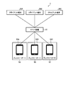
- FIG. 1 is a diagram illustrating a configuration example of a navigation management support system according to the first embodiment.
- FIG. 2 is a block diagram illustrating a functional configuration of the server apparatus according to the first embodiment.
- FIG. 3 is a diagram illustrating an example of navigation data.
- FIG. 4 is a block diagram illustrating a functional configuration of the mobile terminal device according to the first embodiment.
- FIG. 5 is a diagram illustrating an example of the other ship approaching identification range, the dangerous article identification range, and the non-running identification range.
- FIG. 6 is a diagram illustrating an example of a method for setting the non-running identification range.
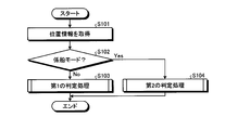
- FIG. 7 is a flowchart illustrating a procedure of alert control processing according to the first embodiment.
- FIG. 8 is a flowchart showing the procedure of the first determination process shown in FIG.
- FIG. 9 is a flowchart showing the procedure of the second determination process shown in FIG.
- FIG. 10 is a diagram illustrating a hardware configuration example of a computer that executes the alert
- FIG. 1 is a diagram illustrating a configuration example of a navigation management support system according to the first embodiment.
- the navigation management support system 1 shown in FIG. 1 provides a navigation management service for managing the operation of a ship belonging to a port using a marina as a user who manages the port. Furthermore, the navigation management support system 1 shown in FIG. 1 provides a navigation support service that supports safe navigation with crew members of ships belonging to a port as end users.
- navigation management services and navigation support services can be applied to any type of ship, but are particularly useful in that they can be applied to small ships. That is, a large vessel is obliged to have marine equipment such as AIS (Automatic Identification System), whereas a small vessel is not obligated to install marine equipment. From such a background, navigation management and navigation support of small vessels, especially vessels used for marine leisure, so-called pleasure boats 5A to 5C, are difficult compared to large vessels.
- AIS Automatic Identification System
- the navigation management support system 1 utilizes the functions installed in the portable terminal devices 50A to 50C possessed by passengers of the pleasure boats 5A to 5C, for example, the ship operator, for the navigation management service and the navigation support service.
- each of the pleasure boats 5A to 5C may be collectively referred to as “pleasure boat 5”.
- the case where the object to which the above navigation management service and the above navigation support service are applied is the pleasure boat 5, but the above navigation management service and the like are also applied to other small vessels such as fishing boats.
- the above navigation support service can be applied.
- the above navigation management service and the above navigation support service can be applied to large vessels by using existing technology such as marine equipment.
- the navigation management support system 1 includes a server device 10, client terminals 30A to 30C, and mobile terminal devices 50A to 50C.
- client terminal 30 may be collectively referred to as “client terminal 30” when collectively referred to.
- mobile terminal device 50 when each of the mobile terminal devices 50A to 50C is generically referred to as “mobile terminal device 50”, it may be described. 1 illustrates a case where the server device 10 accommodates three client terminals 30 and three portable terminal devices 50, but is not limited to the illustrated example, and any number of client terminals 30 and portable terminals may be included.
- the device 50 can be accommodated.
- the server device 10 is a computer that provides the navigation management service to the client terminal 30.
- the server device 10 can be implemented by installing a navigation management program for realizing the navigation management service as package software or online software on a desired computer.
- the server device 10 may be implemented as a Web server that provides the navigation management service described above, or may be implemented as a cloud that provides the navigation management service described above by outsourcing.
- the client terminal 30 is a computer that receives the above navigation management service from the server device 10.
- the client terminal 30 can be used by all persons involved in the marina including a marina staff and a manager.
- a personal computer can be adopted as the client terminal 30.
- the client terminal 30 is not limited to the stationary information processing apparatus such as the personal computer described above, and various portable terminal devices that the marina lends to the parties concerned can also be adopted as the client terminal 30.
- the “mobile terminal device” referred to here includes mobile communication terminals such as smartphones, mobile phones and PHS (Personal Handyphone System), and slate terminals and tablet terminals.
- the client terminal 30 accepts a login request to the server device 10 by accepting input of account information assigned to the marina, such as an ID (IDentification) and a password.
- account information assigned to the marina such as an ID (IDentification) and a password.
- ID IDentification
- password a password assigned to the marina
- login authentication is executed by the server device 10.
- the navigation management service related to the marina is opened to the client terminal 30 that has succeeded in the login authentication.
- the server device 10 and the client terminal 30 are connected via a predetermined network.
- a predetermined network any type of communication network such as the Internet, LAN, VPN (Virtual Private Network), etc. can be adopted regardless of wired or wireless.
- the portable terminal device 50 is used as a computer that provides the navigation support service described above.
- the “portable terminal device 50” referred to here indicates, for example, a device used for a passenger of the pleasure boat 5, such as a boat operator.
- an application program that realizes the navigation support service is installed in the mobile terminal device 50.
- an application program for realizing the navigation support service may be referred to as “navigation support App”.
- the navigation support App By executing the navigation support App on the processor of the mobile terminal device 50, the mobile terminal device 50 can execute various warnings that contribute to safe navigation as an example of the navigation support service.
- the mobile terminal device 50 can automatically or manually enter and exit the port of the pleasure boat 5 on which the boat operator or the like who holds the mobile terminal device 50 is boarding.
- the server apparatus 10 is notified accordingly.
- the notification of departure or entry of the pleasure boat 5 is output by a predetermined display device or audio output device, or the departure notification or entry notification of the pleasure boat 5 is uploaded to the server device 10 to enter the server device 10.
- Providing port entry / departure determination services such as recording port departures.
- the portable terminal device 50 has a warning about dangerous materials such as shoals, reefs and fishing nets, the skill and qualifications of the operator of the pleasure boat 5, during the departure period from the departure of the pleasure boat 5 to the departure port.
- Warnings related to maneuvering beyond the navigation range of pleasure boats 5 determined by the size of the boat warnings about entry into prohibited areas such as harbors and rivers, warnings about running boats to anchored pleasure boats 5,
- Warnings related to maneuvering beyond the navigation range of pleasure boats 5 determined by the size of the boat warnings about entry into prohibited areas such as harbors and rivers, warnings about running boats to anchored pleasure boats 5,
- Implement a wide range of warnings including warnings of non-compliance with rules, warnings of approaching other vessels, for example, small vessels and large vessels in general.
- the mobile terminal device 50 provides the server device 10 with location information measured by a position detection unit mounted on the mobile terminal device 50, for example, a GPS (Global Positioning System) receiver, in the above-described departure period. Upload. Accordingly, the mobile terminal device 50 constructs a base for the server device 10 to provide the navigation management service to the client terminal 30. Under such a base, the server device 10 can manage, for example, the entry / exit of the pleasure boat 5 and the current position after the departure of the pleasure boat 5. In addition to this, the server device 10 includes a harbor where marina has jurisdiction over a symbol of a dangerous substance that accepts an emergency rescue request for the pleasure boat 5 from the mobile terminal device 50 or that causes the mobile terminal device 50 to perform a warning, and the surrounding sea area.
- a position detection unit mounted on the mobile terminal device 50 for example, a GPS (Global Positioning System) receiver
- the mobile terminal device 50 constructs a base for the server device 10 to provide the navigation management service to the client terminal 30. Under such a base, the server device 10 can manage,
- the server device 10 and the mobile terminal device 50 can communicate with each other via an arbitrary network connected through a base station in which the mobile terminal device 50 is accommodated.
- illustration was abbreviate
- FIG. 2 is a block diagram illustrating a functional configuration of the server apparatus 10 according to the first embodiment.
- the server device 10 includes a communication I / F unit 11, a storage unit 13, and a control unit 15.
- a solid line representing the input / output relationship of data is shown, but this is only shown for the minimum part for convenience of explanation. That is, the input / output of data related to each processing unit is not limited to the illustrated example, and the input / output of data other than those illustrated, for example, between the processing unit and the processing unit, between the processing unit and the data, and between the processing unit and the external Data input / output between devices may be performed.
- the communication I / F unit 11 is an interface that performs communication control with other devices such as the client terminal 30 and the mobile terminal device 50.
- a network interface card such as a LAN card can be adopted as an aspect of the communication I / F unit 11.
- the communication I / F unit 11 transmits map display data related to the jurisdiction of the marina to the client terminal 30 or position information such as dangerous objects that cause the mobile terminal device 50 to perform a warning, such as shallow water, reefs, and fishing nets. Are received from the client terminal 30.
- the communication I / F unit 11 receives a download request for navigation support App, location information of the pleasure boat 5, and an alert output status in the mobile terminal device 50 from the mobile terminal device 50, or the navigation support App and the client terminal 30.
- the position information of the dangerous goods set in the server device 10 is transmitted to the portable terminal device 50 by the instruction input from.
- the storage unit 13 is a storage device that stores data used for various programs such as an OS (Operating System) executed by the control unit 15 and application programs for realizing the navigation management service.
- OS Operating System
- the storage unit 13 can be implemented as an auxiliary storage device in the server device 10.
- the storage unit 13 may employ an HDD (Hard Disk Drive), an optical disk, an SSD (Solid State Drive), or the like.
- the storage unit 13 does not necessarily have to be implemented as an auxiliary storage device, and can also be implemented as a main storage device in the server device 10.
- various semiconductor memory elements such as RAM (Random Access Memory) and flash memory can be employed for the storage unit 13.
- the storage unit 13 stores map data 13a, navigation support data 13b, and navigation data 13c as an example of data used in a program executed by the control unit 15.
- map data 13a the navigation support data 13b, and the navigation data 13c
- attribute information about the ship for example, information in which the ship name, the captain name, and the number of crew members are associated with each ship number can be stored together.
- the navigation support data 13b will be described when the navigation support data 13b is referred to.
- the map data 13a is electronic chart data. Such charts include types such as general charts, charts of navigation, charts of voyages, coastal charts, and charts of harbor stays. All or part of these charts are stored in the storage unit 13 as map data 13a. In the map data 13a, the entire map included in the map data 13a is divided into meshes. For this reason, when the server device 10 transmits the map data 13a to the client terminal 30 or the mobile terminal device 50, the entire map included in the map data 13a may not necessarily be transmitted, and a part of the map data 13a is transmitted. be able to.
- the map data 13a when the map data 13a is transmitted from the server device 10 to the client terminal 30, the map data of elements corresponding to the jurisdiction corresponding to the client terminal 30 or a part of the jurisdiction are extracted from the map data 13a. Is transmitted. Further, when the map data 13a is transmitted from the server device 10 to the mobile terminal device 50, the position information designated by the mobile terminal device 50, that is, the map data of the element corresponding to a predetermined range based on the current position is the map data. 13a is extracted and transmitted.
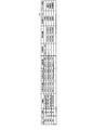
- Navigation data 13c is data relating to navigation.
- the navigation data 13c may include data including items such as a marina ID, a departure ID, a ship ID, a scheduled departure date, a scheduled entry date, a departure date, a departure date, a current location, and the like.
- the “marina ID” here refers to the identification information of the marina, and for example, an identifier of an arbitrary system can be used as long as the server device 10 can identify the marina.
- the “departure ID” refers to information for identifying a ship that departs from a port managed by the marina. For example, the numbers are taken in the order in which the departure notifications are submitted out of the deportation notifications whose scheduled departure date is the same day. Be numbered.
- the “ship ID” refers to information for identifying the ship, and for example, a ship number assigned to the ship can be used. The ship number may be referred to as a “ship identification number”.
- the date and time when the departure notification is received is registered for the first time when the departure notification is received from the portable terminal device 50.
- the date and time when the port entry notification is received is registered in the “port entry date and time” only when the port entry notification is received from the mobile terminal device 50.
- the “current position” is overwritten with the uploaded position information every time it is uploaded for a predetermined period, for example, every minute, from the mobile terminal device 50 in which the status regarding entry / exit is set to “departing”.
- FIG. 3 is a diagram showing an example of the navigation data 13c.
- a record relating to a marina identified by the marina ID “M001” is extracted and shown.
- the ship identified by the ship ID “JP-DEF54321N505”, the ship identified by the ship ID “JP-HIJ56789J123”, and the ship ID “JP-HIJ98765J200” are identified.
- the ship is leaving the marina identified by the marina ID “M001”.
- the vessel identified by the vessel ID “JP-DEF54321N505” has an alert “running”, and the vessel identified by the vessel ID “JP-HIJ98765J200” Alert alert is output.
- the ship identified by the ship ID “JP-HIJ56789J123” no alert is output, but a notification indicating that the ship has been anchored, that is, is being moored, has been uploaded.
- the status column may not be provided, and other items may be added and stored.
- the alert state may be stored in association with the ship ID. If the data items can be stored and referenced in association with each other, the data need not be stored together in one table, but may be divided into a plurality of tables and managed.
- the control unit 15 has an internal memory for storing various programs and control data, and executes various processes using these.
- control unit 15 is implemented as a central processing unit, a so-called CPU (Central Processing Unit).
- CPU Central Processing Unit
- the control unit 15 does not necessarily have to be implemented as a central processing unit, and may be implemented as an MPU (Micro Processing Unit).
- MPU Micro Processing Unit
- the control unit 15 can be realized by hard wired logic such as ASIC (Application Specific Integrated Circuit) or FPGA (Field Programmable Gate Array).
- the control unit 15 realizes the above navigation management service in the storage unit 13 on a RAM work area such as DRAM (Dynamic Random Access Memory) or SRAM (Static Random Access Memory) implemented as a main storage device (not shown).
- a RAM work area such as DRAM (Dynamic Random Access Memory) or SRAM (Static Random Access Memory) implemented as a main storage device (not shown).
- control unit 15 includes a distribution unit 15a, a navigation recording unit 15b, an alert receiving unit 15c, and a map display unit 15d.
- the distribution unit 15 a is a processing unit that performs distribution to the mobile terminal device 50.
- the distribution unit 15 a distributes the navigation support data 13 b stored in the storage unit 13 to the mobile terminal device 50 when a download request for the navigation support App is received from the mobile terminal device 50.
- the navigation support data 13b includes the navigation support App data and various data used by the navigation support App.
- data used by the navigation support App there is a positional information such as a dangerous object set in the server device 10 by an instruction input from the client terminal 30, for example, a shallow, a reef or a fishing net.
- the delivery part 15a delivers the position information of another ship for the portable terminal device 50 which accepts the departure notification and does not accept the entry notification.
- the distribution unit 15a obtains the position information of the other ship whose current position is included within a predetermined range, for example, 1 km from the current position of the mobile terminal device 50 among the current positions included in the navigation data 13c. Delivered to the mobile terminal device 50.
- the position information of another ship can be distributed in the same cycle as the cycle in which the mobile terminal device 50 uploads the current position. It is also possible to distribute the position information of other ships in a cycle shorter than the cycle in which the current position 50 is uploaded, for example, a cycle in which the position information is sampled by the mobile terminal device 50.
- the distribution unit 15a further distributes the current position of the large vessel uploaded to the server device 10 through the marine equipment such as AIS, not only at the current position of the pleasure boat 5 included in the navigation data 13c, to the portable terminal device 50. You can also.
- the navigation recording unit 15b is a processing unit that records navigation.
- the navigation recording unit 15b when the navigation recording unit 15b receives a departure notification from the portable terminal device 50, the navigation recording unit 15b performs the following process. That is, the navigation recording unit 15b includes the record stored in the storage unit 13 as the navigation data 13c at the departure date of the record having the same marina ID and departure ID as the marina ID and departure ID included in the departure notification. Record the date and time when the departure notice was received as the departure date and time.
- the case where both the marina ID and the port ID are used for the search of the record is assumed assuming that the port IDs that overlap between the marina are numbered, but there are different port IDs between the marinas. When numbering is performed, records can be searched using only the departure ID.
- the navigation recording part 15b performs the following processes, when the port notification is received from the portable terminal device 50. That is, the navigation recording unit 15b includes the record stored in the storage unit 13 as the navigation data 13c at the port entry date and time of the record having the same marina ID and departure ID as the marina ID and departure port ID included in the port entry notification. Record the date and time when the port entry notification was received as the port entry date and time. Furthermore, the navigation recording unit 15b executes the following process every time position information is notified from the mobile terminal device 50. That is, the navigation recording unit 15b stores the current position of the record stored in the storage unit 13 as the navigation data 13c and having the same Marina ID and Departure ID as the Marina ID and Departure ID notified together with the position information. Overwrites and updates the position information.
- the alert receiving unit 15 c is a processing unit that receives an alert execution notification from the mobile terminal device 50.
- the alert receiving unit 15 c receives an alert execution notification including the type of alert output from the mobile terminal device 50 from the mobile terminal device 50.
- the map display unit 15d is a processing unit that displays a map on the client terminal 30.
- the map display unit 15d executes the following process when receiving a monitoring screen viewing request on a menu screen (not shown) displayed on the client terminal 30. For example, the map display unit 15d identifies the marina ID from the account used at the time of login authentication by the client terminal 30 that has made the monitoring screen setting request. Subsequently, the map display unit 15d further identifies a jurisdiction corresponding to the previously identified marina ID by referring to jurisdiction data (not shown) in which the marina's jurisdiction is associated with each marina ID of the marina. To do. And the map display part 15d extracts the map data containing the jurisdiction area corresponding to the marina ID specified previously from the map data 13a memorize
- a record in which the current position is registered is extracted from the records included in the navigation data 13c, and the ship included in the record is extracted. Can be mapped.
- the attribute information related to the ship can be displayed on the client terminal 30 in association with the symbol representing the ship.
- Ship attribute information can also be displayed in a window separate from the monitoring screen.
- the display form of the symbols of the ships for which the alert notification is received by the alert receiving unit 15c is different from the symbols of the other ships.
- the symbol of the ship can be displayed in a different display form for each type of output performed on the mobile terminal device 50.
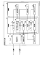
- FIG. 4 is a block diagram illustrating a functional configuration of the mobile terminal device 50 according to the first embodiment.
- the mobile terminal device 50 includes a touch panel 51, a wireless communication unit 52, a camera 53, a position detection unit 54, a storage unit 55, and a control unit 57.
- various functional units included in known mobile terminal devices, such as an audio output unit, may be included.
- the touch panel 51 is a displayable and inputable device.
- the touch panel 51 displays an image output by an application program such as the above-described navigation support App, including the OS executed on the mobile terminal device 50.
- the touch panel 51 receives touch operations such as tap, flick, sweep, pinch-in, and pinch-out performed on the screen of the touch panel 51.
- the touch panel 51 is illustrated as an example of the display unit. However, it is not always necessary to have both functions of display and input, and a device capable of realizing only the display function may be mounted.
- the wireless communication unit 52 connects to a base station via an antenna (not shown), thereby transmitting / receiving data to / from another device, for example, the server device 10 via a mobile communication network connected to the base station. It is a processing part to perform.
- the camera 53 is an imaging device that captures an image.
- the camera 53 is mounted with an image sensor such as a CCD (Charge Coupled Device) or a CMOS (Complementary Metal Oxide Semiconductor).
- the camera 53 can be equipped with three or more light receiving elements such as R (red), G (green), and B (blue).
- the position detection unit 54 is a kind of hardware that detects the position of the mobile terminal device 50.
- the position detector 54 may be a GPS receiver that measures the position from time information transmitted from a plurality of GPS satellites.
- the position measured by the GPS receiver is not necessarily used as it is, and various corrections can be performed using position information transmitted from the base station to which the mobile terminal device 50 is connected.
- the storage unit 55 is a storage device that stores data used in various programs such as an application program including the OS executed by the control unit 57.
- the storage unit 55 can be implemented as a main storage device in the server device 10.
- various semiconductor memory elements for example, RAMs such as DRAM and SRAM, and flash memories can be employed.
- the storage unit 55 does not necessarily have to be mounted as a main storage device, and can also be mounted as an auxiliary storage device of the mobile terminal device 50.
- the storage unit 55 can employ an HDD, an optical disc, an SSD, or the like.
- the storage unit 55 stores navigation support data 55a, mode data 55b, and other ship position data 55c as an example of data used in the program executed by the control unit 57.
- user data of the portable terminal device 50 can be stored together.
- the control unit 57 is a processing unit that controls the entire mobile terminal device 50.
- control unit 57 is implemented as a central processing unit, a so-called CPU.
- control unit 57 is not necessarily implemented as a central processing unit, and may be implemented as an MPU.
- the control unit 57 can also be realized by a hard wired logic such as ASIC or FPGA.
- control unit 57 includes a download unit 57a and a navigation support App execution unit 58.
- the download unit 57a is a processing unit that executes various downloads.
- the navigation support App is started to be downloaded when a two-dimensional barcode issued by the marina is read through the camera 53 of the mobile terminal device 50.
- An example of a scene in which such a two-dimensional bar code is read is a scene in which a port departure notification is submitted to the marina.
- the departure notification is submitted to the marina in this way, after the departure ID is assigned by the server device 10, the marina ID of the marina where the departure notification is accepted together with the departure ID, the ship ID accepted by the departure notification, A new record in which the scheduled departure date and time and the scheduled entry date and time are associated is generated in the navigation data 13c.
- address information such as a URL (Uniform Resource Locator) accessible to the server device 10, a marina ID, and a port ID are encoded.
- a two-dimensional barcode including a marina ID and a departure ID is generated.
- the two-dimensional barcode including the URL, the marina ID, and the departure ID is obtained by the camera 53 capturing an image of the paper on which the two-dimensional barcode is printed or the screen of the display device on which the two-dimensional barcode is displayed. Read.
- URL Uniform Resource Locator
- the download unit 57a refers to the address of the URL and downloads the navigation support App including the marina ID and the departure ID. Perform to server device 10.
- the navigation support data including the navigation support App included in the navigation support data 13b and various data used by the navigation support App is downloaded from the server device 10 as the navigation support data 55a.
- the marina ID, the departure port ID, and the like are also registered in the storage unit 55 in order to identify the marina to which the pleasure boat 5 belongs and the individual of the pleasure boat 5 on the server device 10.
- the download unit 57a starts the navigation support App execution unit 58 by expanding the navigation support App downloaded from the server device 10 on a RAM work area such as the storage unit 55.
- the mobile terminal device 50 can start providing the navigation support service. It should be noted that the navigation support App continues to operate in the background even after the navigation operation App is completed by the user until the departure and entry of the port submitted in the port departure notification are completed after being activated by the portable terminal device 50. To do.
- the navigation support App execution unit 58 includes an acquisition unit 58a, a reception unit 58b, an alert control unit 58c, a determination unit 58d, and a data transfer unit 58e.
- the acquisition unit 58a is a processing unit that acquires position information.
- the acquisition unit 58a acquires position information from the position detection unit 54 every time the position is detected by the position detection unit 54.
- position information latitude and longitude coordinates are acquired.
- the position detection unit 54 acquires position information sampled at a predetermined period, for example, 5 seconds.
- the accepting unit 58b is a processing unit that accepts an input of a throwing instruction or an input indicating that it is in a throwing state.
- the accepting unit 58 b when a marine equipment that automatically performs throwing is mounted on the pleasure boat 5, the accepting unit 58 b sends a throwing instruction that is accepted by the marine equipment from the marine equipment to the portable terminal device 50. It can be accepted by transferring.
- the control for automatically executing the throwing and the process for transferring the throwing instruction to the portable terminal device 50 are executed together.
- the reception part 58b can also receive the input which means that the pleasure boat 5 transfers to a mooring state via input means, such as the touch panel 51.
- the reception unit 58b displays a throwing button indicating that the throwing has been performed on the pleasure boat 5 on the touch panel 51, or displays a mooring button indicating that the pleasure boat 5 is being moored on the touch panel 51. To do. By accepting the pressing operation of any of these buttons, the accepting unit 58b can accept an input indicating that it is in the throwing state.
- the receiving unit 58b sets the mode data 55b stored in the storage unit 55 to the mooring mode indicating the mooring state. To do. Thereafter, when the lifting operation is received by the above-described marine equipment, the reception unit 58b indicates that the lifting button or the pleasure boat 5 is in navigation indicating that the drawing is performed on the pleasure boat 5. When the button pressing operation is accepted, the mode data 55b stored in the storage unit 55 is set to the navigation mode indicating the navigation state.
- the alert control unit 58c is a processing unit that reduces the types of triggers that output alerts according to the mode data 55b.
- the alert control unit 58c determines whether an alert is sent to the determination unit 58d described later depending on whether the mode data 55b stored in the storage unit 55, that is, whether the stay mode is “navigation mode” or “mooring mode”. By changing the types of alerts that determine whether output is necessary, the types of triggers that output alerts are reduced. That is, when the stay mode is the “mooring mode”, the alert control unit 58c does not execute the determination regarding the dangerous goods performed when the stay mode is the “navigation mode”.
- the alert control unit 58c causes the determination unit 58d to execute the following first determination process.
- first determination process as an example, “dangerous material determination” for determining whether or not there is a dangerous object in front of the pleasure boat 5 and within a predetermined range from the current position of the pleasure boat 5 “Other ship approach determination” for determining whether or not another ship is approaching is included.
- second determination process does not include the above “dangerous object determination”, and determines whether or not the other boat approach determination and the pleasure boat 5 are crushed. "Running judgment”.
- the determination unit 58d is a processing unit that determines whether to output various alerts.
- the determination unit 58d executes “dangerous object determination” and “other ship approach determination” when the “first determination process” is selected by the alert control unit 58c.
- the determination unit 58d performs “running determination” and “other ship approach determination”.
- the determination unit 58d sets a range for identifying that another ship has approached the pleasure boat 5 corresponding to the portable terminal device 50 based on the position information acquired by the acquisition unit 58a. .
- a range for identifying that another ship has approached the pleasure boat 5 corresponding to the mobile terminal device 50 may be referred to as “another ship approach identification range”.
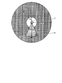
- FIG. 5 is a diagram illustrating an example of the other ship approaching identification range, the dangerous article identification range, and the non-running identification range.
- the determination unit 58 d identifies other ship approaching in the range of the radius R ⁇ b> 1 from the current position P of the mobile terminal device 50 on the pleasure boat 5, for example, the darkest hatched portion shown in FIG. 5.
- Set as a range As an example of the radius R1, a 500 m range can be adopted.
- the determination unit 58d refers to the other vessel position data 55c stored in the storage unit 55 under such setting of the other vessel approach identification range.
- the other ship position data 55c is position information of other ships, for example, general ships including small ships and large ships, and is registered by being downloaded from the server device 10 by the data transfer unit 58e described later as an example. Then, the determination unit 58d determines whether the position information of the other ship included in the other ship position data 55c is included in the other ship approach identification range. At this time, when the position information of the other ship is included in the other ship approach identification range, it is determined that the other ship is approaching the pleasure boat 5.
- the determination unit 58d outputs a message indicating that the other ship is approaching the pleasure boat 5 as an alert on the touch panel 51, or the sound effect indicating that the other ship is approaching the pleasure boat 5 or the above Is output as an alert to a speaker or the like (not shown).
- the determination part 58d sets the range identified as dangerous objects, such as shallow water, a reef, and a fishing net, ahead of the pleasure boat 5 based on the positional information acquired by the acquisition part 58a.
- a range that identifies a dangerous substance in front of the pleasure boat 5 may be referred to as a “dangerous substance identification range”.
- the dangerous object identification range is set in front of the pleasure boat 5 in the traveling direction.
- the determination unit 58d includes the position information acquired by the acquisition unit 58a and the past position information acquired before that, for example, the position information acquired one hour ago.
- the traveling direction F of the pleasure boat 5 is specified from the change in the position information determined from the following.
- said angle (alpha) can be increased / decreased by weather data, such as the direction and magnitude
- the angle ⁇ can be set larger as the wind direction, wind magnitude, wave direction, or wave magnitude increases.
- the determination unit 58d refers to the position information of the dangerous substance included in the navigation support data 55a stored in the storage unit 55. Then, the determination unit 58d determines whether or not the dangerous substance position information is included in the dangerous substance identification range. At this time, if the position information of the dangerous object is included in the dangerous object identification range, it is determined that the dangerous object exists in front of the pleasure boat 5. In this case, the determination unit 58d displays and outputs a message on the touch panel 51 as an alert that there is a dangerous substance in front of the pleasure boat 5, or a sound effect that the dangerous substance exists in front of the pleasure boat 5 or the above Is output as an alert to a speaker or the like (not shown).
- the determination unit 58d sets a range for identifying that the occupant pleasure boat 5 holding the mobile terminal device 50 is not in the state of the trial based on the position information acquired by the acquisition unit 58a. .
- the range in which the pleasure boat 5 is identified as not being in the running state is sometimes referred to as a “non-running identification range”.
- the determination The part 58d sets a range from the throwing position P where the throwing is performed by the pleasure boat 5 to the radius R3, for example, a white hatched portion shown in FIG.
- FIG. 6 is a diagram illustrating an example of a method for setting the non-running identification range.
- the pleasure boat 5 when throwing by the pleasure boat 5, the pleasure boat 5 is swung around concentrically centering on the position A of an anchor by the influence of a wind direction or a wave direction. For this reason, although it depends on the strength of the wind, the strength of the waves, the weight and area of the ship, it is preferable to estimate a value 3 to 5 times the water depth d as an example of the length L of the anchor rope.
- the angle ⁇ of the anchor rope is preferably estimated to be close to 10 degrees when the weather such as wind strength or wave strength is bad, and 20 degrees or less even when the weather is normal. Otherwise, there is a risk of scrambling.
- water depth d, anchor rope length L, and anchor rope angle ⁇ can be acquired as known when the stay mode is set to “mooring mode”.
- the value measured by the water depth measuring device can be acquired via the touch panel 51 or the like. If the water depth d can be acquired in this way, the recommended value of the length L of the anchor rope can be calculated by multiplying the water depth d by a predetermined multiplier, for example, three times.
- the recommended value of the length L of the anchor rope can be displayed on the touch panel 51 when the water depth d is input, thereby instructing the occupant of the pleasure boat 5 of the length of the anchor rope suitable for the water depth.
- the angle ⁇ of the anchor rope can also be set by inputting the weather condition via the touch panel 51. For example, an input of either “good” weather or “bad” weather is received on the touch panel 51, and when the weather “good” is input, the angle ⁇ of the anchor rope is set to 19 degrees, and the weather is “bad”. Can be set to 11 degrees. By omitting such an input, a value that is 20 degrees or less, which is the upper limit, for example, 19 degrees can be used as a fixed value.
- the radius R3 of the scribble recognition range can be obtained. That is, by substituting the depth of water d and the length L of the anchor rope into the following formula (1), the radius R3 of the non-running-stalk recognition range can be calculated. For example, when the water depth d is 10 m and the length L of the anchor rope is 30 m, the radius R3 of the non-running anchor recognition range can be obtained as 28.2 degrees according to the following equation (1).
- angle ⁇ of the anchor rope is also calculated by substituting the water depth d and the length L of the anchor rope into the following formula (2) for obtaining the inverse trigonometric function of the sine.
- An appropriate anchor rope length L ′ can be further calculated from d and displayed on the touch panel 51 or the like.
- the determination unit 58d determines whether or not the position information acquired by the acquisition unit 58a, that is, whether or not the current position of the pleasure boat 5 deviates from the non-skeletal identification range. judge. At this time, if the current position of the pleasure boat 5 deviates from the non-running identification range, it is determined that the pleasure boat 5 is running. In this case, the determination unit 58d displays a message indicating that the pleasure boat 5 is running on the touch panel 51 as an alert, or alerts the sound effect that the pleasure boat 5 is running or the above message. The voice is output to a speaker or the like (not shown).
- the data exchanging unit 58 e is a processing unit that exchanges data with the server device 10 such as uploading or downloading of data.
- the data transfer unit 58 e when the data transfer unit 58 e receives a port entry operation or a port departure operation via the touch panel 51, the data transfer unit 58 e uploads a port departure notification or a port arrival notification to the server device 10. Further, the data exchanging unit 58e uploads the position information measured by the position detecting unit 54 to the server device 10 in the port departure period from when the port departure operation is received through the touch panel 51 to when the port entry operation is received.
- the position information is uploaded in this way, the position information can be uploaded every time the position information is measured by the position detection unit 54.
- the position detection unit 54 has a period longer than the period at which the position detection unit 54 samples the position information. You can also upload location information.
- the data transfer unit 58 e downloads the position information of the other ship from the server device 10.
- the position information of the other ship thus downloaded is registered in the storage unit 55 as the other ship position data 55c.
- the data transfer unit 58e uploads an alert execution notification including the type of the alert, the marina ID, and the departure ID to the server device 10.
- FIG. 7 is a flowchart illustrating a procedure of alert control processing according to the first embodiment. As an example, this process is repeatedly executed over a port departure period from when the port departure operation is received from the touch panel 51 to when the port entry operation is received.
- the port departure period is determined by automatically determining the departure or entry of the pleasure boat 5 with respect to the port using existing technology. It does not matter if you specify it.
- the alert control unit 58c has the mode data 55b stored in the storage unit 55, that is, the stay mode is “mooring mode”. Whether or not (step S102).
- the alert control unit 58c includes “dangerous goods determination” and “other ship approach determination”.
- the determination part 58d is made to perform the 1st determination process (step S103), and a process is complete
- the alert control unit 58c causes the determination unit 58d to execute a second determination process including “running determination” and “other ship approach determination” ( Step S104) and the process ends.
- FIG. 8 is a flowchart showing the procedure of the first determination process shown in FIG. This process corresponds to the process of step S103 shown in FIG. 7, and is executed when the stay mode is “navigation mode” as an example.
- the determination unit 58d sets a dangerous goods identification range according to the position information acquired in step S101, that is, the current position of the pleasure boat 5 (step S301). For example, the determination unit 58d identifies the trajectory between the current position of the pleasure boat 5 and the position acquired in the past, that is, the traveling direction F of the pleasure boat 5, and the traveling direction of the pleasure boat 5 from the current position of the pleasure boat 5 A range within a predetermined distance toward F, and a range rotated clockwise and counterclockwise from a traveling direction F of the pleasure boat 5 around the current position of the pleasure boat 5 over a predetermined angle. Set to the dangerous goods identification range.
- the determination unit 58d determines whether or not the dangerous object position information included in the navigation support data 55a stored in the storage unit 55 is included in the dangerous object identification range set in step S301 (step S302). .
- step S302 when the position information of the dangerous substance is included in the dangerous substance identification range (step S302 Yes), it is determined that there is a dangerous substance in front of the pleasure boat 5.
- the determination unit 58d displays and outputs a message on the touch panel 51 as an alert that there is a dangerous substance in front of the pleasure boat 5, or a sound effect that the dangerous substance exists in front of the pleasure boat 5 or the above Is output as an alert to an unillustrated speaker or the like (step S303). If the dangerous substance position information is not included in the dangerous substance identification range (No in step S302), the process of step S303 is skipped and the process proceeds to step S304.
- the determination unit 58d sets a range of a predetermined radius from the current position of the pleasure boat 5 acquired in step S101 as the other ship approach identification range (step S304). Then, the determination unit 58d determines whether or not the position information of the other ship included in the other ship position data 55c is included in the other ship approach identification range set in step S304 (step S305).
- step S305 Yes if the position information of the other ship is included in the other ship approach identification range (step S305 Yes), it is determined that the other ship is approaching the pleasure boat 5.
- the determination unit 58d outputs a message indicating that the other ship is approaching the pleasure boat 5 as an alert on the touch panel 51, or the sound effect indicating that the other ship is approaching the pleasure boat 5 or the above Is output as an alert to a speaker (not shown) or the like (step S306), and the process ends. If the position information of the other ship is not included in the other ship approach identification range (step S305 No), the process of step S306 is skipped and the process is terminated.
- FIG. 9 is a flowchart showing the procedure of the second determination process shown in FIG. This process corresponds to the process of step S104 shown in FIG. 7, and is executed when the stay mode is “mooring mode” as an example.
- the determination unit 58d is position information acquired by the acquisition unit 58a at the time when throwing is performed by the pleasure boat 5, that is, at the time when input of a throwing instruction is received by the receiving unit 58b.
- a range of a predetermined radius from the throwing position P is set as a non-running discrimination range (step S501).
- the determination unit 58d determines whether or not the current position of the pleasure boat 5 acquired in step S101 deviates from the non-running rifle identification range set in step S501 (step S502).
- step S503 if the current position of the pleasure boat 5 deviates from the non-running identification range (Yes in step S502), it is determined that the pleasure boat 5 is running. In this case, the determination unit 58d displays a message indicating that the pleasure boat 5 is running on the touch panel 51 as an alert, or alerts the sound effect that the pleasure boat 5 is running or the above message. As a voice output to a speaker (not shown) or the like (step S503), and the process is terminated.
- step S504 when the current position of the pleasure boat 5 is included in the non-running identification range (No in step S502), the determination unit 58d cancels the output of the alert related to the running boat (step S504). That is, when an alert related to scribble is output according to the sampled position information before the position information is sampled in step S101, the output of the alert is canceled, and no alert related to scribble is output The process of step S504 is skipped.
- the determination unit 58d sets a range of a predetermined radius from the current position of the pleasure boat 5 acquired in step S101 as the other ship approach identification range (step S505). Then, the determination unit 58d determines whether or not the position information of the other ship included in the other ship position data 55c is included in the other ship approach identification range set in step S505 (step S506).
- step S506 Yes when the position information of the other ship is included in the other ship approach identification range (step S506 Yes), it is determined that the other ship is approaching the pleasure boat 5.
- the determination unit 58d outputs a message indicating that the other ship is approaching the pleasure boat 5 as an alert on the touch panel 51, or the sound effect indicating that the other ship is approaching the pleasure boat 5 or the above Is output as an alert to a speaker (not shown) or the like (step S507), and the process ends. If the position information of the other ship is not included in the other ship approach identification range (step S506 No), the process of step S507 is skipped and the process is terminated.
- the navigation management support system 1 is a trigger that outputs an alert in response to an input of a throwing instruction to the pleasure boat 5 or an input that the pleasure boat 5 is in a throwing state. Reduce the number of types. Therefore, according to the navigation management support system 1 according to the present embodiment, it is possible to suppress the output of an extra alert for the vessel operator.
- the server device 10 may execute the navigation support App on the processor. That is, the server device 10 stores the navigation data 13c, which is the data from which the other ship position data 55c is distributed, in the storage unit 13, and stores the navigation support data 13b corresponding to the navigation support data 55a. For this reason, by setting a storage area for storing the mode data 55b in the storage unit 13 and periodically transmitting the position information from the portable terminal device 50 to the server device 10, the server device 10 is shown in FIGS. Can be executed.
- each component of each illustrated apparatus does not necessarily need to be physically configured as illustrated.
- the specific form of distribution / integration of each device is not limited to that shown in the figure, and all or a part thereof may be functionally or physically distributed or arbitrarily distributed in arbitrary units according to various loads or usage conditions. Can be integrated and configured.
- the distribution unit 15a, the navigation recording unit 15b, the alert receiving unit 15c, or the map display unit 15d may be connected as an external device of the server device 10 via a network.
- part or all of the processing included in the navigation support App execution unit 58 may be connected as an external device of the mobile terminal device 50 via a network.
- FIG. 10 is a diagram illustrating a hardware configuration example of a computer that executes the alert control program according to the first and second embodiments.
- the computer 100 includes an operation unit 110a, a speaker 110b, a camera 110c, a display 120, and a communication unit 130. Further, the computer 100 includes a CPU 150, a ROM 160, an HDD 170, and a RAM 180. These units 110 to 180 are connected via a bus 140.
- the HDD 170 stores an alert control program 170a that exhibits the same function as the navigation support App execution unit 58 shown in the first embodiment.
- This alert control program 170a may be integrated or separated as with each component of the navigation support App execution unit 58 shown in FIG. That is, the HDD 170 does not necessarily have to store all the data shown in the first embodiment, and data used for processing may be stored in the HDD 170.
- the CPU 150 reads the alert control program 170a from the HDD 170 and expands it in the RAM 180.
- the alert control program 170a functions as an alert control process 180a as shown in FIG.
- the alert control process 180a expands various data read from the HDD 170 in an area allocated to the alert control process 180a in the storage area of the RAM 180, and executes various processes using the expanded various data.
- examples of processing executed by the alert control process 180a include processing shown in FIGS. Note that the CPU 150 does not necessarily operate all the processing units described in the first embodiment, and the processing unit corresponding to the process to be executed may be virtually realized.
- alert control program 170a may not necessarily be stored in the HDD 170 or the ROM 160 from the beginning.
- each program is stored in a “portable physical medium” such as a flexible disk inserted into the computer 100, so-called FD, CD-ROM, DVD disk, magneto-optical disk, or IC card. Then, the computer 100 may acquire and execute each program from these portable physical media.
- each program is stored in another computer or server device connected to the computer 100 via a public line, the Internet, a LAN, a WAN, etc., and the computer 100 acquires and executes each program from these. It may be.
Landscapes
- Chemical & Material Sciences (AREA)
- Engineering & Computer Science (AREA)
- Combustion & Propulsion (AREA)
- Mechanical Engineering (AREA)
- Ocean & Marine Engineering (AREA)
- Health & Medical Sciences (AREA)
- Public Health (AREA)
- Traffic Control Systems (AREA)
- Navigation (AREA)
Abstract
La présente invention concerne un système informatique de commande d'alerte, comportant: une unité (58b) de réception qui reçoit des entrées d'instructions d'ancrage et des entrées indiquant un état ancré; et une unité (58c) de commande d'alerte qui réduit les types de déclencheurs générant des alertes en réponse aux entrées d'instructions d'ancrage et aux entrées indiquant l'état ancré.
Priority Applications (3)
| Application Number | Priority Date | Filing Date | Title |
|---|---|---|---|
| PCT/JP2016/054033 WO2017138128A1 (fr) | 2016-02-10 | 2016-02-10 | Système informatique de commande d'alerte, procédé de commande d'alerte, et programme de commande d'alerte |
| JP2017566475A JP6562090B2 (ja) | 2016-02-10 | 2016-02-10 | アラート制御に関するコンピュータシステム、アラート制御方法及びアラート制御プログラム |
| US16/056,854 US10940924B2 (en) | 2016-02-10 | 2018-08-07 | Alert control system using mode of ship, alert control method using mode of ship, and recording medium storing alert control program using mode of ship |
Applications Claiming Priority (1)
| Application Number | Priority Date | Filing Date | Title |
|---|---|---|---|
| PCT/JP2016/054033 WO2017138128A1 (fr) | 2016-02-10 | 2016-02-10 | Système informatique de commande d'alerte, procédé de commande d'alerte, et programme de commande d'alerte |
Related Child Applications (1)
| Application Number | Title | Priority Date | Filing Date |
|---|---|---|---|
| US16/056,854 Continuation US10940924B2 (en) | 2016-02-10 | 2018-08-07 | Alert control system using mode of ship, alert control method using mode of ship, and recording medium storing alert control program using mode of ship |
Publications (1)
| Publication Number | Publication Date |
|---|---|
| WO2017138128A1 true WO2017138128A1 (fr) | 2017-08-17 |
Family
ID=59563602
Family Applications (1)
| Application Number | Title | Priority Date | Filing Date |
|---|---|---|---|
| PCT/JP2016/054033 Ceased WO2017138128A1 (fr) | 2016-02-10 | 2016-02-10 | Système informatique de commande d'alerte, procédé de commande d'alerte, et programme de commande d'alerte |
Country Status (3)
| Country | Link |
|---|---|
| US (1) | US10940924B2 (fr) |
| JP (1) | JP6562090B2 (fr) |
| WO (1) | WO2017138128A1 (fr) |
Cited By (3)
| Publication number | Priority date | Publication date | Assignee | Title |
|---|---|---|---|---|
| CN107607092A (zh) * | 2017-08-22 | 2018-01-19 | 哈尔滨工程大学 | 一种基于无人机遥感的波浪与浮体运动预报系统 |
| JP2023182181A (ja) * | 2022-06-14 | 2023-12-26 | 日本無線株式会社 | 船舶監視装置、船舶監視方法 |
| JP7854865B2 (ja) | 2022-06-14 | 2026-05-07 | 日本無線株式会社 | 船舶監視装置、船舶監視方法 |
Families Citing this family (3)
| Publication number | Priority date | Publication date | Assignee | Title |
|---|---|---|---|---|
| WO2017138128A1 (fr) * | 2016-02-10 | 2017-08-17 | 富士通株式会社 | Système informatique de commande d'alerte, procédé de commande d'alerte, et programme de commande d'alerte |
| DK181059B1 (en) * | 2018-11-16 | 2022-10-24 | Maersk Drilling As | Dynamic positioning control |
| JP7725297B2 (ja) * | 2021-09-01 | 2025-08-19 | 古野電気株式会社 | 標準航路生成装置、船舶監視装置 |
Citations (4)
| Publication number | Priority date | Publication date | Assignee | Title |
|---|---|---|---|---|
| JPS61112982A (ja) * | 1984-11-08 | 1986-05-30 | Oki Electric Ind Co Ltd | 走錨等危険監視装置 |
| JP2012022446A (ja) * | 2010-07-13 | 2012-02-02 | Ship Security Service Co Ltd | 乗揚防止援助装置、乗揚防止援助システム、および乗揚防止援助プログラム |
| JP2012155359A (ja) * | 2011-01-21 | 2012-08-16 | Icom Inc | ターゲット識別装置およびターゲット移動予測方法 |
| JP2015164006A (ja) * | 2014-02-28 | 2015-09-10 | 日本無線株式会社 | 情報配信装置、情報配信システム及び情報配信方法 |
Family Cites Families (26)
| Publication number | Priority date | Publication date | Assignee | Title |
|---|---|---|---|---|
| US2507986A (en) * | 1946-06-06 | 1950-05-16 | Liss Russel | Shoal water indicator |
| US3579182A (en) * | 1969-03-19 | 1971-05-18 | Leonard Schneider | Anchor dragging alarm control based on anchor inclination |
| US5261344A (en) * | 1991-11-21 | 1993-11-16 | The United States Of America As Represented By The Secretary Of The Navy | Self-contained system for surface ship protection against moored contact mines |
| US5251185A (en) * | 1992-10-15 | 1993-10-05 | Raytheon Company | Sonar signal processor and display |
| DE19716684B4 (de) * | 1997-04-21 | 2009-11-26 | Deep Blue Technology Ag | Anker-/Ankerketten-Überwachungsvorrichtung |
| US5932815A (en) * | 1997-12-19 | 1999-08-03 | Dodds; Donald J. | Anchor monitoring system |
| US6561860B2 (en) * | 2000-10-18 | 2003-05-13 | Constantine N. Colyvas | Maneuvering enhancer for twin outboard motor boats |
| JP3737955B2 (ja) | 2001-03-27 | 2006-01-25 | 株式会社光電製作所 | 航法装置 |
| US6804607B1 (en) * | 2001-04-17 | 2004-10-12 | Derek Wood | Collision avoidance system and method utilizing variable surveillance envelope |
| JP2003341592A (ja) * | 2002-05-24 | 2003-12-03 | Yamaha Motor Co Ltd | 船舶用の制御用パラメータ選択装置及びこの装置を備えた航走制御システム |
| US6970578B1 (en) * | 2002-07-16 | 2005-11-29 | The United States Of America As Represented By The Secretary Of The Navy | Method of generating images to aid in the detection of manmade objects in cluttered underwater environments |
| JP2005140546A (ja) | 2003-11-04 | 2005-06-02 | Keiichiro Ogawa | 低温拡散反射測定装置及びそれに用いる試料ホルダ、低温拡散反射スペクトル測定方法 |
| ITSV20040023A1 (it) * | 2004-05-17 | 2004-08-17 | Ultraflex Spa | Impianto e metodo per comando direzionale di natanti, come imbarcazioni o simili |
| US20080251000A1 (en) * | 2006-10-06 | 2008-10-16 | Blakesley Kim | Anchoring system |
| DE102007007346B3 (de) | 2007-02-14 | 2008-08-21 | Siemens Ag | Verfahren und Vorrichtung zur Verbesserung der Verkehrssicherheit von Verkehrsmitteln |
| JP2012233743A (ja) * | 2011-04-28 | 2012-11-29 | Furuno Electric Co Ltd | 情報表示装置 |
| US9135826B2 (en) * | 2012-12-26 | 2015-09-15 | Sap Se | Complex event processing for moving objects |
| CH707573A1 (de) * | 2013-02-07 | 2014-08-15 | Thomas Frizlen | Verfahren und System zur Bestimmung der Verlagerung eines Ankers. |
| US9324120B2 (en) * | 2013-06-07 | 2016-04-26 | Emergency University, Inc. | Method and apparatus for emergency response notification |
| FR3010799B1 (fr) * | 2013-09-13 | 2015-08-28 | Thales Sa | Systeme de detection et de localisation d'objets immerges flottant entre deux eaux tels que des mines a orins et procede associe |
| US20150116496A1 (en) * | 2013-10-29 | 2015-04-30 | Ottarr, Llc | Camera, Sensor and/or Light-Equipped Anchor |
| JP6382996B2 (ja) * | 2014-09-16 | 2018-08-29 | 古野電気株式会社 | 自船周囲情報表示装置及び自船周囲情報表示方法 |
| CN104574825A (zh) * | 2015-01-05 | 2015-04-29 | 陈力行 | 水域定位报警器 |
| WO2016166812A1 (fr) * | 2015-04-14 | 2016-10-20 | 日本郵船株式会社 | Dispositif à des fins d'assistance à la maintenance de l'équipement-marin, programme, et support de stockage |
| US9815532B2 (en) * | 2015-08-30 | 2017-11-14 | Rodney Scott Shumate | Device for detecting dislogded anchoring apparatus and the like |
| WO2017138128A1 (fr) * | 2016-02-10 | 2017-08-17 | 富士通株式会社 | Système informatique de commande d'alerte, procédé de commande d'alerte, et programme de commande d'alerte |
-
2016
- 2016-02-10 WO PCT/JP2016/054033 patent/WO2017138128A1/fr not_active Ceased
- 2016-02-10 JP JP2017566475A patent/JP6562090B2/ja not_active Expired - Fee Related
-
2018
- 2018-08-07 US US16/056,854 patent/US10940924B2/en not_active Expired - Fee Related
Patent Citations (4)
| Publication number | Priority date | Publication date | Assignee | Title |
|---|---|---|---|---|
| JPS61112982A (ja) * | 1984-11-08 | 1986-05-30 | Oki Electric Ind Co Ltd | 走錨等危険監視装置 |
| JP2012022446A (ja) * | 2010-07-13 | 2012-02-02 | Ship Security Service Co Ltd | 乗揚防止援助装置、乗揚防止援助システム、および乗揚防止援助プログラム |
| JP2012155359A (ja) * | 2011-01-21 | 2012-08-16 | Icom Inc | ターゲット識別装置およびターゲット移動予測方法 |
| JP2015164006A (ja) * | 2014-02-28 | 2015-09-10 | 日本無線株式会社 | 情報配信装置、情報配信システム及び情報配信方法 |
Cited By (3)
| Publication number | Priority date | Publication date | Assignee | Title |
|---|---|---|---|---|
| CN107607092A (zh) * | 2017-08-22 | 2018-01-19 | 哈尔滨工程大学 | 一种基于无人机遥感的波浪与浮体运动预报系统 |
| JP2023182181A (ja) * | 2022-06-14 | 2023-12-26 | 日本無線株式会社 | 船舶監視装置、船舶監視方法 |
| JP7854865B2 (ja) | 2022-06-14 | 2026-05-07 | 日本無線株式会社 | 船舶監視装置、船舶監視方法 |
Also Published As
| Publication number | Publication date |
|---|---|
| US10940924B2 (en) | 2021-03-09 |
| US20180339753A1 (en) | 2018-11-29 |
| JPWO2017138128A1 (ja) | 2018-10-25 |
| JP6562090B2 (ja) | 2019-08-21 |
Similar Documents
| Publication | Publication Date | Title |
|---|---|---|
| JP6551549B2 (ja) | 入出港判定に関するコンピュータシステム、入出港判定方法及び入出港判定プログラム | |
| JP6932487B2 (ja) | 移動体監視装置 | |
| US11027814B2 (en) | Ship reverse-run detection system, ship reverse-run detection method, and recording medium storing ship reverse-run detection program | |
| JP6562090B2 (ja) | アラート制御に関するコンピュータシステム、アラート制御方法及びアラート制御プログラム | |
| JP7221576B1 (ja) | 船舶におけるデータ通信システム | |
| CN105928521B (zh) | 一种航海用导航方法与系统 | |
| KR102798853B1 (ko) | 항만 운영 관리 장치 및 항만 운영 관리 방법 | |
| KR101882417B1 (ko) | 선박의 음성 경보 장치 및 그의 제어 방법 | |
| JP2022062137A (ja) | 災害情報共有システム、災害情報共有方法、移動体制御システム、及び移動体制御方法 | |
| KR20210115665A (ko) | 차세대 전자해도 시스템 기초 해양 안전 관리 서비스의 운용 방법 | |
| JP6639195B2 (ja) | 船舶監視装置 | |
| US12374227B1 (en) | Smartphone marine vessel location and collision avoidance system | |
| JPH05233999A (ja) | 船舶安全管理支援方法およびその装置 | |
| JP7502639B2 (ja) | 通信装置およびその制御方法 | |
| US11735054B1 (en) | Smartphone marine vessel location and collision avoidance system and methods of use | |
| KR20200041183A (ko) | 스마트디바이스를 이용한 대피지원시스템 | |
| KR20230094467A (ko) | 객체 검출 방법 및 객체 검출 장치 | |
| JP7396746B1 (ja) | 航路標識管理システム、航路標識管理プログラム、及び航路標識管理方法 | |
| KR20210078589A (ko) | 무인 비행기를 이용한 항만 접안 지원 장치 및 방법 | |
| JP2023058963A (ja) | 避難情報提供システム | |
| JP2020016974A (ja) | 船舶用安全管理情報システム | |
| JP6652792B2 (ja) | 情報配信システム及び情報配信方法 | |
| JP2023051745A (ja) | 操作支援装置、操作支援方法及びプログラム | |
| Sakkopoulos et al. | Mobile Data Fusion from Multiple Tracking Sensors to Augment Maritime Safety: Mobile Detection, Early Identification, and Tracking of Moving Objects | |
| TWM598407U (zh) | 用於監控水上行動載具位置的電子裝置 |
Legal Events
| Date | Code | Title | Description |
|---|---|---|---|
| 121 | Ep: the epo has been informed by wipo that ep was designated in this application |
Ref document number: 16889830 Country of ref document: EP Kind code of ref document: A1 |
|
| ENP | Entry into the national phase |
Ref document number: 2017566475 Country of ref document: JP Kind code of ref document: A |
|
| NENP | Non-entry into the national phase |
Ref country code: DE |
|
| 122 | Ep: pct application non-entry in european phase |
Ref document number: 16889830 Country of ref document: EP Kind code of ref document: A1 |