WO2017170142A1 - Terminal de communication, dispositif serveur, système de guidage de mouvement, et programme informatique - Google Patents
Terminal de communication, dispositif serveur, système de guidage de mouvement, et programme informatique Download PDFInfo
- Publication number
- WO2017170142A1 WO2017170142A1 PCT/JP2017/011780 JP2017011780W WO2017170142A1 WO 2017170142 A1 WO2017170142 A1 WO 2017170142A1 JP 2017011780 W JP2017011780 W JP 2017011780W WO 2017170142 A1 WO2017170142 A1 WO 2017170142A1
- Authority
- WO
- WIPO (PCT)
- Prior art keywords
- information
- guidance
- communication terminal
- server device
- route
- Prior art date
- Legal status (The legal status is an assumption and is not a legal conclusion. Google has not performed a legal analysis and makes no representation as to the accuracy of the status listed.)
- Ceased
Links
Images



Classifications
-
- G—PHYSICS
- G08—SIGNALLING
- G08G—TRAFFIC CONTROL SYSTEMS
- G08G1/00—Traffic control systems for road vehicles
- G08G1/09—Arrangements for giving variable traffic instructions
- G08G1/0962—Arrangements for giving variable traffic instructions having an indicator mounted inside the vehicle, e.g. giving voice messages
- G08G1/0968—Systems involving transmission of navigation instructions to the vehicle
- G08G1/096805—Systems involving transmission of navigation instructions to the vehicle where the transmitted instructions are used to compute a route
- G08G1/096811—Systems involving transmission of navigation instructions to the vehicle where the transmitted instructions are used to compute a route where the route is computed offboard
-
- G—PHYSICS
- G01—MEASURING; TESTING
- G01C—MEASURING DISTANCES, LEVELS OR BEARINGS; SURVEYING; NAVIGATION; GYROSCOPIC INSTRUMENTS; PHOTOGRAMMETRY OR VIDEOGRAMMETRY
- G01C21/00—Navigation; Navigational instruments not provided for in groups G01C1/00 - G01C19/00
- G01C21/26—Navigation; Navigational instruments not provided for in groups G01C1/00 - G01C19/00 specially adapted for navigation in a road network
- G01C21/34—Route searching; Route guidance
- G01C21/36—Input/output arrangements for on-board computers
- G01C21/3691—Retrieval, searching and output of information related to real-time traffic, weather, or environmental conditions
- G01C21/3694—Output thereof on a road map
-
- G—PHYSICS
- G01—MEASURING; TESTING
- G01C—MEASURING DISTANCES, LEVELS OR BEARINGS; SURVEYING; NAVIGATION; GYROSCOPIC INSTRUMENTS; PHOTOGRAMMETRY OR VIDEOGRAMMETRY
- G01C21/00—Navigation; Navigational instruments not provided for in groups G01C1/00 - G01C19/00
- G01C21/26—Navigation; Navigational instruments not provided for in groups G01C1/00 - G01C19/00 specially adapted for navigation in a road network
- G01C21/34—Route searching; Route guidance
- G01C21/36—Input/output arrangements for on-board computers
- G01C21/3667—Display of a road map
- G01C21/367—Details, e.g. road map scale, orientation, zooming, illumination, level of detail, scrolling of road map or positioning of current position marker
-
- G—PHYSICS
- G01—MEASURING; TESTING
- G01C—MEASURING DISTANCES, LEVELS OR BEARINGS; SURVEYING; NAVIGATION; GYROSCOPIC INSTRUMENTS; PHOTOGRAMMETRY OR VIDEOGRAMMETRY
- G01C21/00—Navigation; Navigational instruments not provided for in groups G01C1/00 - G01C19/00
- G01C21/38—Electronic maps specially adapted for navigation; Updating thereof
- G01C21/3863—Structures of map data
- G01C21/387—Organisation of map data, e.g. version management or database structures
- G01C21/3881—Tile-based structures
-
- G—PHYSICS
- G06—COMPUTING OR CALCULATING; COUNTING
- G06F—ELECTRIC DIGITAL DATA PROCESSING
- G06F16/00—Information retrieval; Database structures therefor; File system structures therefor
- G06F16/20—Information retrieval; Database structures therefor; File system structures therefor of structured data, e.g. relational data
- G06F16/29—Geographical information databases
-
- G—PHYSICS
- G09—EDUCATION; CRYPTOGRAPHY; DISPLAY; ADVERTISING; SEALS
- G09B—EDUCATIONAL OR DEMONSTRATION APPLIANCES; APPLIANCES FOR TEACHING, OR COMMUNICATING WITH, THE BLIND, DEAF OR MUTE; MODELS; PLANETARIA; GLOBES; MAPS; DIAGRAMS
- G09B29/00—Maps; Plans; Charts; Diagrams, e.g. route diagram
-
- H—ELECTRICITY
- H04—ELECTRIC COMMUNICATION TECHNIQUE
- H04W—WIRELESS COMMUNICATION NETWORKS
- H04W4/00—Services specially adapted for wireless communication networks; Facilities therefor
- H04W4/02—Services making use of location information
- H04W4/024—Guidance services
Definitions
- the present invention relates to a communication terminal, a server device, a movement guidance system, and a computer program that perform movement guidance of a moving object.
- the navigation device detects the current position of the vehicle by a GPS receiver or the like, acquires map information corresponding to the current position through a recording medium such as a DVD-ROM or HDD or a network, and displays it on the liquid crystal monitor. It is a device that can do.
- the navigation device has a route search function for searching for an optimum route from a departure point (for example, the current position of the host vehicle) to the set destination when a desired destination is set. It also has a travel guidance function for guiding travel according to the route (guide route).
- some mobile phones, PDAs (Personal Digital Assistants), smart phones, personal computers, and the like have the same functions as the above navigation devices (hereinafter referred to as communication terminals including navigation devices).
- new roads are built every year in Japan. Along with this, existing roads disappear, intersections are added, and the shapes of existing roads and intersections are changed. At this time, there is a problem that information regarding a new road or the like newly created after the map information of the communication terminal is created is not registered in the map information. In other words, in communication terminals with map information that does not include new roads, etc., new roads etc. are not subject to route search or guidance, so search for long-distance guide routes that do not pass through new roads, etc. However, there are cases where appropriate travel guidance is not performed, such as being not guided on a map image.
- a configuration has been proposed in which a route search is not performed on the communication terminal side but is executed by a server device having the latest map information and a guide route is acquired from the server device (hereinafter referred to as a center route search).
- a center route search is performed, a route can be searched based on the latest map information, while on the communication terminal side having an old version of map information, travel guidance along the guide route can be appropriately performed.
- travel guidance along the guide route can be appropriately performed.
- guidance in an incorrect direction is performed based on old map information.
- a server device when a server device receives a route search request from a navigation device, a route search is performed while a route search is performed.
- the mesh code and version information of the mesh through which the route passes are transmitted to the navigation device together with the searched route.
- corresponding mesh data (map information) based on the mesh code and version information transmitted from the server device Has been proposed for requesting the server device for the latest version of mesh data for a mesh determined to be older than the mesh data stored in the server device.
- a route search is first performed in the server device, and after determining the guide route, it is determined whether or not it is necessary to obtain the latest version of mesh data from the server device. If it is determined that the latest version of the mesh data needs to be acquired, the navigation device requests the mesh data from the navigation device again. Therefore, it takes a very long time to obtain the necessary mesh data after the guide route is set. During this time, guidance based on the guide route cannot be performed, or wrong guidance is performed. Occurs.
- a communication terminal can be obtained by acquiring in advance guidance information for performing movement guidance of a mobile object.
- a communication terminal a server device, a movement guidance system, and a computer program that prevent a movement guidance based on a guidance route from being performed or an occurrence of an erroneous guidance from occurring after obtaining a guidance route from For the purpose.
- a communication terminal is connected to a server device so as to be capable of two-way communication, and transmits a route search request to a destination to the server device, and in response to the route search request, It is a communication terminal which acquires the route searched and distributed in the server device. Specifically, while setting the destination or transmitting the route search request to the server device, the terminal-side map information of the communication terminal with respect to the device-side map information of the server device is an old version.
- Guidance information requesting means for requesting guidance information for performing movement guidance of the moving body from the server device, targeting at least the update target area around the current position among the update target areas that are map information areas;
- Guidance information receiving means for receiving the guidance information transmitted from the server device in response to a request for the guidance information, a guidance route set in the communication terminal, and the guidance information received by the guidance information receiving means;
- Guiding means for guiding the movement of the moving body.
- the “moving body” includes a pedestrian and a two-wheeled vehicle in addition to the vehicle.
- the “map information version” includes the creation time of the map information, the update time when the map information was finally updated, and the map update information (update program) at the time of the final update. Including any of the times.
- the computer program according to the present invention transmits a route search request to a destination to a server device connected so as to be capable of bidirectional communication, and is searched and distributed in the server device in response to the route search request.
- a computer program for obtaining a route Specifically, the communication terminal performs destination setting or transmission of the route search request to the server device, and the terminal-side map information of the communication terminal with respect to the device-side map information of the server device.
- the server device is connected to a communication terminal so as to be capable of two-way communication, receives a route search request from the communication terminal to a destination, and searches for a route searched according to the received route search request.
- a server device that distributes to the communication terminal.
- guidance information request receiving means for receiving a request for guidance information for performing a moving guidance of a mobile body from the communication terminal for setting a destination or transmitting the route search request to the server device; , At least the update target area around the current position among the update target areas in which the terminal side map information of the communication terminal is an old version of map information with respect to the device side map information of the server device
- Guidance information transmitting means for transmitting the guidance information to the communication terminal in response to a request for the guidance information.
- the travel guidance system is connected to a server device and the server device so as to be capable of two-way communication, transmits a route search request to a destination to the server device, and responds to the route search request.
- a communication terminal for acquiring a route searched and distributed in the server device.
- the communication terminal sets a destination or transmits the route search request to the server device, and the terminal-side map information of the communication terminal is older than the device-side map information of the server device.
- Guidance information requesting means for requesting guidance information for performing movement guidance of the moving body from the server device, targeting at least the updating target area around the current position in the update target area, which is an area serving as version map information
- a guide information receiving means for receiving the guide information transmitted from the server device in response to the request for the guide information, a guide route set in the communication terminal, and the guide received by the guide information receiving means.
- Guidance means for performing movement guidance of the mobile body using information and the server device sends a request for the guidance information to the communication terminal. It has a guidance information request receiving means for receiving, and a guidance information transmitting means for transmitting the guidance information of the target area to said communication terminal in response to a request of the guidance information from.
- the server device, the movement guidance system, and the computer program according to the present invention having the above-described configuration, when performing the center route search, by obtaining in advance the guidance information for performing the movement guidance of the moving body, After the communication terminal acquires the guidance route from the server device, it is possible to prevent as much as possible the occurrence of an event in which travel guidance based on the guidance route is not performed or erroneous guidance is performed. As a result, even when the map information of the communication terminal is an older version of the map information than the map information of the server device, it is possible to appropriately guide the moving body based on the guidance route searched by the server device. Is possible. Further, instead of map information (including facility data, data used for route search, etc. in addition to guide information for performing travel guidance), guide information as a part thereof is selectively acquired from the server device in advance. Therefore, the amount of information distribution can be reduced as compared with the case of acquiring map information.
- map information including facility data, data used for route search, etc. in addition to guide information for performing travel guidance
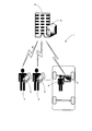
- FIG. 1 is a schematic configuration diagram showing a movement guide system 1 according to the first embodiment.
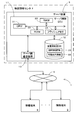
- FIG. 2 is a block diagram showing a configuration of the movement guide system 1 according to the first embodiment.
- the travel guidance system 1 basically includes a server device 3 included in a map information center 2 and a communication terminal 5 possessed by a user 4.
- the server device 3 and the communication terminal 5 are configured to be able to transmit / receive electronic data to / from each other via the communication network 6.
- Examples of the communication terminal 5 include a mobile phone, a smartphone, a tablet terminal, a personal computer, and a navigation device.
- the user 4 may be in a state of getting on the vehicle, or may be in a state of not getting on the vehicle.
- the server device 3 performs a route search in response to a request from the communication terminal 5. Specifically, when a destination is set in the communication terminal 5 or when a route re-search (reroute) is performed, it is necessary for a route search from the communication terminal 5 to the server device 3 such as a departure point and a destination. Information is transmitted together with the route search request (however, in the case of re-search, it is not always necessary to transmit information regarding the destination). Then, the server device 3 that has received the route search request performs a route search using the map information of the server device 3 and specifies a recommended route from the departure point to the destination. Thereafter, the specified recommended route is transmitted to the requesting communication terminal 5.
- the communication terminal 5 sets the received recommended route as a guide route, and performs movement guidance according to the guide route. Thereby, even if the map information that the communication terminal 5 has at the time of route search is an old version of map information, it is possible to set an appropriate guide route based on the latest version of map information that the server device 3 has. Become.
- the server device 3 In addition to the distribution of the search route, the server device 3 also distributes the travel guidance information for performing the travel guidance of the user in the communication terminal 5 in response to the request of the communication terminal 5.
- the travel guidance information is created based on the latest version of the map information, and as described later, the current position in the communication terminal 5 is identified in correspondence with the latest version of the map information, the simple travel guidance along the guide route, and the image. This is information for displaying.
- the communication terminal 5 uses the travel guide information distributed from the server device 3, so that even if the map information of the communication terminal 5 is an old version of map information, the server device is based on the latest version of map information. It is possible to carry out the movement guidance along the guidance route searched in 3.
- the communication terminal 5 is an information terminal possessed by the user 4 and having a navigation function, and includes, for example, a mobile phone, a smartphone, a tablet terminal, a personal computer, a navigation device, and the like.
- the navigation function searches for a route corresponding to the condition specified by the user, displays a map image around the current position of the user 4, and displays the current position of the user 4 in the displayed map image. Or a function of performing movement guidance along a set guidance route. Note that it is not necessary for the communication terminal 5 to have all of the above-mentioned navigation functions. If the communication terminal 5 has at least a function for searching for a route and a function for performing movement guidance along a set guide route, the present invention will be described. It is possible to configure.
- the communication network 6 includes a large number of base stations arranged in various parts of the country and a communication company that manages and controls each base station.
- the base station and the communication company are connected to each other by wire (optical fiber, ISDN, etc.) or wirelessly. It is configured by connecting.
- the base station has a transceiver (transmitter / receiver) for communicating with the communication terminal 5 and an antenna.
- the base station performs wireless communication between the communication companies, and relays communication between the communication terminal 5 that is at the end of the communication network 6 and is within the range (cell) of the base station's radio waves to and from the server device 3. Have a role to play.
- the server device 3 includes a server control ECU 11, a device-side map DB 12 as information recording means connected to the server control ECU 11, and a server-side communication device 13.
- the server control ECU 11 (electronic control unit) is an electronic control unit that performs overall control of the server device 3, and is used as a working memory when the CPU 21 performs various types of arithmetic processing as well as the arithmetic unit and the control unit.
- an internal storage device such as a ROM 23 storing a movement guide processing program (see FIGS. 6 and 7) described later, a flash memory 24 storing a program read from the ROM 23, and the like is provided. ing.
- the server control ECU 11 has various means as processing algorithms together with an ECU of the communication terminal 5 described later.
- the guidance information request receiving means receives from the communication terminal 5 a request for movement guidance information for performing movement guidance of a mobile body (for example, the user himself / herself or vehicle).
- the guide information transmitting means transmits the travel guide information of the target area to the communication terminal 5 in response to the request for travel guide information.
- the device-side map DB 12 stores device-side map information 25, which is the latest version of map information registered based on input data and input operations from the outside, for each area (for example, each level 10 mesh of 20 km square). It is a memory
- the version is used to specify when the map information was created, when the final update was performed, or when the map update information (update program) was created when the final update was performed. It is possible to specify the time when map information was created by referring to the version.
- the apparatus-side map information 25 has basically the same configuration as the map information stored in the communication terminal 5, and is necessary for route search, route guidance, and map display including the road network. It consists of various information. For example, link data regarding roads (links), node data regarding node points, intersection data regarding each intersection, point data regarding points such as facilities, map display data for displaying a map, search data for searching for a route, points It consists of search data and the like for searching.
- a search cost such as a cost obtained by quantifying the appropriate degree as a route for an intersection (hereinafter referred to as an intersection cost) or a cost obtained by quantifying an appropriate degree as a route for a link constituting a road (hereinafter referred to as a link cost). Cost calculation data used for calculation is stored.
- the device-side map DB 12 includes information for specifying the current position and performing simple travel guidance along the guidance route in the communication terminal 5 corresponding to the latest version of map information separately from the device-side map information 25. Certain travel guidance information 26 is also stored separately for each area (for example, for each level 13 mesh of 2.5 km square).
- the movement guide information 26 includes matching data necessary for map matching of the current position of the user, and guidance for causing the user to move along a guidance route such as a left / right turn guidance at a guidance intersection.
- the matching data includes data for specifying the road shape, for example.
- the guidance data includes, for example, data for specifying the shape of the intersection and the connection relationship between the intersection and the road.
- the display data includes data for displaying a map image including a road network and a guidance screen for performing movement guidance on the display of the communication terminal 5.
- server control ECU11 performs the route search from a departure place to the destination using the apparatus side map information 25, when the route search request
- the server control ECU 11 also distributes the travel guidance information 26 to the communication terminal 5 as necessary.
- the communication terminal 5 is an area in which the communication terminal 5 may move in the future (for example, the vicinity of the current position of the communication terminal 5 or the vicinity of the guide route set by the communication terminal 5).
- the travel guidance information 26 of the target area is given to the communication terminal 5. It is configured to deliver to.
- the server side communication device 13 is a communication device for communicating with the communication terminal 5 via the communication network 6.
- information such as traffic information, regulation information, traffic accident information, etc. transmitted from the Internet network or traffic information center, for example, VICS (registered trademark: Vehicle Information and Communication System) center or probe center, etc. It is also possible to receive traffic information consisting of
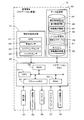
- FIG. 3 is a block diagram schematically showing a control system of the navigation device which is the communication terminal 5 according to the first embodiment.
- the communication terminal 5 includes a current position detection unit 31 that detects a current position of a vehicle (moving body) on which a navigation device that is the communication terminal 5 is mounted, and various types of data.
- a recorded data recording unit 32 a navigation ECU 33 that performs various arithmetic processes based on the input information, an operation unit 34 that receives operations from the user, and a guide route to the map and destination for the user
- a liquid crystal display 35 that displays a voice guidance for route guidance, a DVD drive 37 that reads a DVD as a storage medium, and a communication module 38 that communicates with the server device 3, the VICS center, and the like.
- the current position detection unit 31 includes a GPS 41, a vehicle speed sensor 42, a steering sensor 43, a gyro sensor 44, and the like, and can detect the current vehicle position, direction, vehicle traveling speed, current time, and the like.
- the vehicle speed sensor 42 is a sensor for detecting a moving distance and a vehicle speed of the vehicle, generates a pulse according to the rotation of the driving wheel of the vehicle, and outputs a pulse signal to the navigation ECU 33.
- navigation ECU33 calculates the rotational speed and moving distance of a driving wheel by counting the pulse which generate
- the data recording unit 32 reads an external storage device and a hard disk (not shown) as a recording medium, a terminal-side map DB 45, a version management DB 46, a cache 47, a predetermined program, and the like recorded on the hard disk and stores them on the hard disk. And a recording head (not shown) as a driver for writing predetermined data.
- the data recording unit 32 may be constituted by a nonvolatile memory, a memory card, an optical disk such as a CD or a DVD, instead of the hard disk.
- the terminal-side map DB 45 is a storage unit that stores terminal-side map information 48 used for route search and travel guidance in the communication terminal 5.
- the terminal-side map information 48 stored in the terminal-side map DB 45 is composed of various information necessary for route search, route guidance, and map display including the road network, like the device-side map information 25 described above.
- link data relating to roads (links) node data relating to node points
- intersection data relating to each intersection point data relating to points such as facilities
- map display data for displaying a map search data for searching for a route
- search data for searching for a point for searching for a route
- search data for searching for a point for searching for a point.
- the terminal-side map information 48 stored in the terminal-side map DB 45 is based on map update information distributed from a map distribution server (not shown) or map update information acquired from a recording medium. By rewriting the data, the map information is updated to a new version in units of sections (for example, mesh units). In addition, it is possible to update the entire map information instead of the section unit.
- the terminal-side map DB 45 also includes information on movement guidance information 26 for specifying the current position, traveling guidance along the guidance route, and displaying images in the communication terminal 5 corresponding to the map information for each area (for example, 2 .5km square level 13 meshes) and stored.
- the version management DB 46 is information that identifies the version of the terminal-side map information 48 that is currently stored in the terminal-side map DB 45 (for example, the version number, the last update date and time, the map update information that has been finally updated (update This is a storage means for recording the creation date and time of the program) for each partition unit (for example, mesh unit) of the map information.
- the version management DB 46 is updated as the terminal-side map information 48 is updated to a new version of map information.
- the version management DB 46 identifies an area (hereinafter referred to as an update target area) in which the terminal-side map information 48 of the communication terminal 5 becomes the old version of map information with respect to the apparatus-side map information 25 of the server device 3.
- an update area table (area identification information) 49 is stored.
- the update area table 49 is a table in which a flag that identifies a partition that corresponds to the update target area and a partition that does not correspond to the update target area is associated with each map information partition unit (for example, mesh unit). .
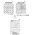
- An example of the update area table 49 is shown in FIG.
- FIG. 4 there is a new road, and among the meshes constituting the device-side map information 25 of the server device 3, a total of six meshes in the corresponding area have a new version “50” from the previous version “50”. The state updated to 60 ′′ is shown.
- the terminal-side map information 48 of the communication terminal 5 is not updated at the present time.
- the version “50” of the mesh in which the device-side map information 25 is updated to version “60” is also used. "”. That is, there is an update target area in which the terminal-side map information 48 included in the communication terminal 5 is an old version of map information with respect to the apparatus-side map information 25 included in the server device 3. As shown in FIG.
- the update area table 49 associates a flag for identifying a partition corresponding to the update target area and a partition not corresponding to the update target area in mesh units. Specifically, “0” is associated with the mesh corresponding to the update target area, and “1” is associated with the mesh not corresponding to the update target area.
- an update area table 49 for a 5 ⁇ 5 mesh is shown for the sake of simplification, but the actual update area table 49 includes each mesh ( When the mesh is composed of a plurality of hierarchies, the table is a table in which flags are associated with each other for each area and each hierarchy.
- the navigation ECU 33 refers to the update area table 49 so that the update target area (that is, the terminal-side map information 48 of the communication terminal 5 with respect to the device-side map information 25 of the server device 3 is the old version of the map information. Can be easily identified.
- the update area table 49 is appropriately updated based on update information transmitted from the server device 3 as described later. For example, when the device-side map information 25 or the terminal-side map information 48 is updated to a new version of map information, the update area table 49 is also updated accordingly.
- standard of the area in the update area table 49 uses the reference
- the cache 47 is a storage means for temporarily storing the movement guide information 26 distributed from the server device 3.
- the travel guidance system 1 As described above, there is an area where the vehicle may travel in the future (for example, around the current position of the vehicle, around the guidance route set by the communication terminal 5).
- the movement guidance information 26 Is distributed from the server device 3 and stored in the cache 47.
- the movement guidance information 26 is information for specifying the current position, simple traveling guidance along the guidance route, and displaying an image in the communication terminal 5 corresponding to the latest map information as described above.
- the navigation ECU 33 does not use the old version of map information and travel guidance information stored in the terminal side map DB 45 for areas where the version of the terminal side map information 48 of the communication terminal 5 is older than the device side map information 25.
- the new version of the travel guidance information 26 stored in the cache 47 is used to identify the current position of the vehicle, travel guidance along the guidance route, display images, and the like.
- the remaining priority is set for each section (for example, mesh unit) of the map information.
- the movement guide information 26 stored in the cache 47 is preferentially deleted from the movement guide information 26 of the area section having a low remaining priority.
- the remaining priority is, as will be described later, movement guidance information 26 for area sections where movement guidance information is required in future vehicle movement guidance, more specifically, area divisions located around the current position of the vehicle,
- the movement guidance information 26 in the area section located around the guidance route set in the communication terminal 5 is set higher than the movement guidance information 26 in other area sections.
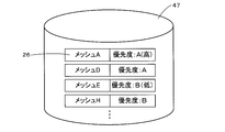
- FIG. 5 is a diagram showing an example of the travel guide information 26 stored in the cache 47.
- the movement guide information 26 is stored by being divided in units of meshes which are map information division units, and the remaining priority is set.
- the remaining priority is set to either “A (high)” or “B (low)”. Therefore, in the example shown in FIG. 5, the movement guidance information 26 of the mesh E and mesh H has a lower priority than the movement guidance information 26 of the mesh A and mesh B, so the mesh E and mesh H have priority from the cache 47. Will be deleted.
- the remaining priority is set at two levels, but it may be set at a finer level. Further, the remaining priority may be stored in association with a mesh (area section) instead of the movement guide information 26.
- the navigation ECU (Electronic Control Unit) 33 is an electronic control unit that performs overall control of the communication terminal 5, and includes a CPU 51 as an arithmetic device and a control device, and a working memory when the CPU 51 performs various arithmetic processes.
- a RAM 52 that stores route data and the like when a route is searched, a ROM 53 that stores a control program, a movement guide processing program (see FIGS. 6 and 7), which will be described later, and the like.
- An internal storage device such as a flash memory 54 for storing a program read from the ROM 53 is provided.
- the navigation ECU 33 has various means as processing algorithms together with the ECU of the server device 3.
- the area specifying unit specifies an update target area that is an area in which the device-side map information 25 included in the communication terminal 5 is an old version of map information with respect to the terminal-side map information 48 included in the server device 3.
- the guidance information requesting means sets a destination or transmits a route search request to the server device 3 and moves to perform vehicle travel guidance from the server device 3 for at least the update target area around the current position. Request guidance information.
- the guide information receiving means receives the travel guide information 26 transmitted from the server device 3 in response to the request for the travel guide information 26.
- the guidance means performs traveling guidance of the vehicle using the guidance route set in the communication terminal 5 and the movement guidance information 26 received by the guidance information receiving means.
- the operation unit 34 is operated when inputting a starting point as a travel start point and a destination as a travel end point, and has a plurality of operation switches (not shown) such as various keys and buttons. Then, the navigation ECU 33 performs control to execute various corresponding operations based on switch signals output by pressing the switches.
- the operation unit 34 may have a touch panel provided on the front surface of the liquid crystal display 35. Moreover, you may have a microphone and a speech recognition apparatus.
- the liquid crystal display 35 has a map image including a road, traffic information, operation guidance, operation menu, key guidance, guidance route from the departure point to the destination, guidance information along the guidance route, news, weather forecast, Time, mail, TV program, etc. are displayed.
- HUD or HMD may be used.
- the speaker 36 outputs voice guidance for guiding traveling along the guidance route and traffic information guidance based on an instruction from the navigation ECU 33.
- the DVD drive 37 is a drive that can read data recorded on a recording medium such as a DVD or a CD. Based on the read data, music and video are played, the terminal-side map DB 45 is updated, and the like. A card slot for reading / writing a memory card may be provided in place of the DVD drive 37.
- the communication module 38 is a communication for receiving information such as map update information, route information, travel guide information, and traffic information transmitted from the server device 3, VICS (registered trademark) center, probe center, and the like.
- VICS registered trademark
- probe center a mobile phone or DCM is applicable.
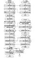
- FIGS. 6 and 7 are flowcharts of the movement guide processing program according to the first embodiment.
- the travel guidance processing program is a program that is executed after the ACC power supply (accessory power supply) of the vehicle is turned on, searches for a route from the departure point to the destination, and performs a travel guidance along the guidance route.
- the communication terminal 5 is a device other than the navigation device, it is executed after the main body power of the communication terminal 5 is turned on (after startup) instead of the ACC power supply.
- the programs shown in the flowcharts of FIGS. 6, 7 and 12 below are stored in the RAM and ROM provided in the server device 3 and the communication terminal 5, and are executed by the CPU 21 or the CPU 51.
- step (hereinafter abbreviated as S) 1 the CPU 51 issues a request for update information (hereinafter referred to as table update information) for updating the update area table 49 of the communication terminal 5 (hereinafter referred to as table update request). It transmits to the server apparatus 3.
- table update information a request for update information
- table update request a request for update information for updating the update area table 49 of the communication terminal 5
- the update area table 49 is a table in which flags for identifying a section corresponding to the update target area and a section not corresponding to the update target area are associated with each unit of map information (for example, mesh unit). Yes (Fig. 4).
- the table update request transmitted in S1 includes the terminal ID that identifies the communication terminal 5 that is the transmission source of the table update information request, and the version of the current terminal-side map information 48 for each section of the map information. Information to identify.
- the creation time of the map update information (update program) in which the terminal-side map information 48 is finally updated (the current map information is created). Information that identifies the corresponding time). Note that the version number and the update date and time when the final update is performed may be transmitted.
- Information for specifying the version of the current terminal-side map information 48 is stored in the version management DB 46.
- the CPU 51 receives the table update information transmitted from the server device 3 in response to the table update request.
- the table update information received in S2 is created by the server device 3 by comparing the current version of the terminal-side map information 48 and the version of the device-side map information 25 (S32).
- the section in which the apparatus-side map information 25 is updated by the map update information created after the creation time of the map update information (update program) in which the information 48 has been finally updated ie, the creation time more than the terminal-side map information 48
- the new device-side map information 25) is updated to the update target area.
- the table update information can be created by comparing the version numbers, but the version number is old. It is necessary to consider that it may be updated (version down) to a number.
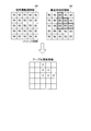
- FIG. 8 is a diagram showing an example of table update information.
- the version of the terminal side map information 48 of the communication terminal 5 is all “50”, and a total of 6 locations are included in each mesh constituting the device side map information 25 of the server device 3.
- the version of the mesh is version “60” updated by the map update information created at a later time than version “50”
- the corresponding six meshes in the update area table 49 are updated to the update target area.
- Table update information is created.
- the update area table 49 associates the flag “0” with the mesh corresponding to the update target area, and associates the flag “1” with the mesh not corresponding to the update target area (FIG. 4).
- the table update information is data in which the flags associated with the corresponding six meshes are rewritten to “0”.
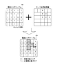
- the CPU 51 updates the update area table 49 based on the table update information received from the server device 3 in S2. Specifically, by combining the update area table 49 and the table update information as shown in FIG. 9, among the flags included in the update area table 49, the mesh specified by the table update information (see FIG. 9). In the example shown, the flags associated with a total of 6 meshes) are rewritten to “0”. Of the meshes specified by the table update information, the mesh whose flag is already “0” is maintained in the “0” state.
- the apparatus-side map information that the server apparatus 3 has at the present time (after the activation of the communication terminal 5 and before requesting the travel guidance information to the server apparatus 3).
- the area (that is, the update target area) in which the terminal-side map information 48 of the communication terminal 5 has the old version of map information can be accurately reflected in the update area table 49. Therefore, for example, when the device-side map information 25 or the terminal-side map information 48 is updated to a new version of map information, the update area table 49 is also updated accordingly.
- the CPU 51 sets the destination of the route in the communication terminal 5.
- the destination is basically set based on a user operation (for example, a registration point reading operation, facility search or selection operation) received by the operation unit 34. However, when performing re-search (reroute), the destination currently set in the communication terminal 5 is continuously set without setting a new destination.
- a user operation for example, a registration point reading operation, facility search or selection operation
- the CPU 51 specifies the current position of the vehicle based on the detection result of the current position detection unit 31 and the map information.
- a map matching process for matching the current position of the vehicle with map information is performed.
- Identification of the current position of the vehicle is basically performed based on the terminal-side map information 48 of the communication terminal 5, but the version of the terminal-side map information 48 in the area where the vehicle is currently located is older than the apparatus-side map information 25.
- it is specified using the travel guide information 26 stored in the cache 47 instead of the old version of map information and travel guide information stored in the terminal-side map DB 45.
- the cache information is specified using old version map information and travel guidance information stored in the terminal-side map DB 45.
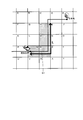
- the CPU 51 specifies “an update target area around the current position of the vehicle” based on the update area table 49 and the current position of the vehicle specified in S5. Specifically, the CPU 51 first specifies a total of 9 meshes of 3 ⁇ 3 centering on the mesh where the vehicle is currently positioned as a mesh around the current position of the vehicle. For example, in the example shown in FIG. 10, the mesh where the vehicle is currently located is “mesh Q”, and therefore the meshes around the current position of the vehicle are meshes K, L, M, P, Q, R centered on mesh Q. , U, V, W.
- the meshes K, L, M, P, Q, R, U, V, and W correspond to the update target area with reference to the update area table 49, and are determined to correspond to the update target area.
- the mesh that is, the mesh associated with the flag “0” in the update area table 49 is specified as the “update target area around the current position of the vehicle”.
- the CPU 51 transmits to the server device 3 a request for the travel guidance information 26 targeted for the “update target area around the current position of the vehicle” specified in S ⁇ b> 6.
- the travel guidance information 26 corresponds to the latest version of the map information of the server device 3 and specifies the current position, simple travel guidance along the guidance route, and image display in the communication terminal 5.
- the request for travel guidance information transmitted in S7 includes the terminal ID that identifies the communication terminal 5 that is the source of the request for travel guidance information, and the area that is the target for requesting travel guidance information (specified in S6).
- Information for example, mesh identification number for specifying “updated area around current position of vehicle”).
- the CPU 51 receives the movement guide information 26 transmitted from the server device 3 in response to the request for the movement guide information 26.
- the travel guidance information 26 is necessary for matching data necessary for map matching of the vehicle and guidance for causing the vehicle to travel along a guidance route such as a left / right turn guidance at a guidance intersection. It includes guidance data and display data for displaying a map image and a guidance screen. That is, the movement guide information 26 received in S8 is information for specifying the current position, simple traveling guidance along the guide route, and displaying an image in the update target area around the current position of the vehicle.
- the processing of S8 is not necessarily performed before the processing of S9 and subsequent steps, and is performed at the timing when the travel guide information 26 is transmitted from the server device 3. Therefore, if the timing at which the travel guide information 26 is transmitted from the server device 3 is delayed, it may be performed during the processing of S9 to S11 or after the processing. However, in order to prevent the movement guidance based on the guidance route from being performed or an erroneous guidance event from occurring, the reception of the movement guidance information (S8) precedes the reception of the searched route information (S12). It is desirable to be carried out. The same applies to S19 and S24 described later.
- the CPU 51 performs a cache management process (FIG. 12) described later.
- the cache management process the travel guide information 26 acquired from the server device 3 is stored in the cache 47 of the communication terminal 5 as will be described later, and unnecessary information is deleted from the cache 47.
- the CPU 51 performs route search processing from the departure place to the destination set in S4 using the terminal-side map information 48 of the communication terminal 5, and a recommended route (from the departure place to the destination ( (Hereinafter referred to as terminal recommended route).
- terminal recommended route a recommended route (from the departure place to the destination (Hereinafter referred to as terminal recommended route).
- the link cost obtained by quantifying the appropriate degree as the route to the link (road), or the route to the intersection (node) As described above, the intersection cost obtained by quantifying the appropriate degree, the toll cost obtained by quantifying the cost required for traveling, and the like are calculated, and the terminal recommended route is searched using each calculated search cost.
- the departure point may be the current position of the vehicle, or may be an arbitrary point (for example, home) designated by the user.
- the CPU 51 transmits a route search request for requesting a route search from the departure point to the destination to the server device 3.
- the route search request the terminal ID that identifies the communication terminal 5 that is the transmission source of the route search request, the departure place (for example, the current position of the vehicle) that is the search condition for the route search, and the purpose set in S4 Information specifying the ground and route information specifying the terminal recommended route searched in S10 are included.
- the destination is basically the same as that at the previous search, and therefore information specifying the destination may not be transmitted.
- route information for specifying the terminal recommended route information specifying the entire terminal recommended route may be transmitted.
- the terminal recommended routes in particular, continuous from the departure point within a predetermined distance from the departure point. Only the information specifying the road train to be transmitted may be transmitted.
- the CPU 51 receives the searched route information transmitted from the server device 3 in response to the route search request.
- the searched route information received in S12 is the destination from the origin searched by the server device 3 using the device-side map information 25 which is the latest version of map information based on the route search request transmitted in S11. This is information regarding a recommended route to the ground (hereinafter referred to as a server recommended route).
- the CPU 51 determines whether or not to set the server recommended route received in S12 as the guide route of the communication terminal 5.
- the server recommended route is basically set as the guide route of the communication terminal 5.
- a route other than the server recommended route such as the terminal recommended route searched by the communication terminal 5 in S10 is a guide route of the communication terminal 5.
- the CPU 51 sets the terminal recommended route searched by the route search process in S10 as a guide route to be a target for vehicle travel guidance in the communication terminal 5. Thereafter, vehicle travel guidance is started based on the set guidance route. For example, display a map image that includes the road network around the location of the vehicle, or display an enlarged view of the guidance branch point when the guidance branch point to be turned right or left approaches a predetermined distance before the vehicle. , Guiding the traveling direction of the vehicle at the guidance branch point.
- the CPU 51 basically performs the travel guidance based on the terminal-side map information 48 and the movement guide information 26 stored in the terminal-side map DB 45.
- the terminal recommended route searched by the route search process of S10 is a route searched based on the terminal-side map information 48 of the communication terminal 5, a new version of travel guidance acquired from the server device 3 is obtained.
- the current position of the vehicle can be specified and guided to the correct position even using the old version of the movement guide information 26 instead of the information 26, and the correct traveling direction of the vehicle can be guided at the guidance intersection.
- the travel guidance may be performed using the travel guidance information 26.
- the CPU 51 sets the server recommended route received in S12 as a guide route that is a target for vehicle travel guidance in the communication terminal 5. Thereafter, vehicle travel guidance is started based on the set guidance route. For example, display a map image that includes the road network around the location of the vehicle, or display an enlarged view of the guidance branch point when the guidance branch point to be turned right or left approaches a predetermined distance before the vehicle. , Guiding the traveling direction of the vehicle at the guidance branch point.
- the CPU 51 basically performs the travel guidance based on the terminal-side map information 48 and the movement guide information 26 stored in the terminal-side map DB 45.
- the cache is acquired from the server device 3 and cached.
- the travel guidance is also performed using the travel guidance information 26 stored in 47.
- the travel guidance information 26 is necessary for matching data necessary for map matching of the vehicle and guidance for causing the vehicle to travel along a guidance route such as a left / right turn guidance at a guidance intersection.
- the CPU 51 specifies the “update target area around the guide route” based on the update area table 49 and the guide route acquired in S16. Specifically, the CPU 51 first identifies a mesh including at least a part of the guide route within a predetermined distance L from the current position of the vehicle to the destination direction as a mesh around the guide route. For example, in the example shown in FIG. 11, meshes including at least a part of the guide route 61 within a predetermined distance L from the current position of the vehicle toward the destination are meshes H, M, Q, and R. Thereafter, it is determined whether the meshes H, M, R, and Q correspond to the update target area with reference to the update area table 49, and the flag “ The mesh associated with “0” is specified as the “update target area around the guide route”.
- the CPU 51 transmits to the server device 3 a request for the travel guidance information 26 targeting the “update target area around the guide route” specified in S6.
- the request for travel guidance information transmitted in S18 includes the terminal ID for specifying the communication terminal 5 that is the source of the request for travel guidance information and the area for which the travel guide information is requested (specified in S17).
- Information for example, mesh identification number for specifying “updated area around guide route”).
- the CPU 51 receives the movement guide information 26 transmitted from the server device 3 in response to the request for the movement guide information 26.
- the travel guidance information 26 is necessary for matching data necessary for map matching of the vehicle and guidance for causing the vehicle to travel along a guidance route such as a left / right turn guidance at a guidance intersection. It includes guidance data and display data for displaying a map image and a guidance screen. That is, the movement guidance information 26 received in S19 is information for specifying the current position, simple traveling guidance along the guidance route, and displaying images in the update target area around the guidance route.
- the CPU 51 performs a cache management process (FIG. 12) described later.
- the cache management process the travel guide information 26 acquired from the server device 3 is stored in the cache 47 of the communication terminal 5 as will be described later, and unnecessary information is deleted from the cache 47.
- the CPU 51 determines whether or not the vehicle has straddled a map information section (for example, a mesh).
- the CPU 51 identifies “an update target area around the current position of the vehicle” and “an update target area around the guide route” based on the update area table 49, the current position of the vehicle, and the guidance route acquired in S16. To do. It should be noted that the process is the same as S6 for specifying the “update target area around the current position of the vehicle”, and the “update target area around the guide route” is the same as S17.
- the CPU 51 requests the server device 3 for the travel guidance information 26 for the “update target area around the current position of the vehicle” and the “update target area around the guide route” specified in S22. And send.
- the request for travel guidance information transmitted in S23 includes the terminal ID that identifies the communication terminal 5 that has transmitted the request for travel guidance information, and the area that is the target for requesting travel guidance information (specified in S21).
- Information for example, mesh identification number
- the CPU 51 receives the movement guide information 26 transmitted from the server device 3 in response to the request for the movement guide information 26.
- the travel guidance information 26 is necessary for matching data necessary for map matching of the vehicle and guidance for causing the vehicle to travel along a guidance route such as a left / right turn guidance at a guidance intersection. It includes guidance data and display data for displaying a map image and a guidance screen. That is, the travel guidance information 26 received in S24 identifies the current position in the update target area around the current position of the vehicle and the update target area around the guide route, displays simple travel guidance along the guide route, and displays an image. Information.
- the CPU 51 performs a cache management process (FIG. 12) described later.
- the cache management process the travel guide information 26 acquired from the server device 3 is stored in the cache 47 of the communication terminal 5 as will be described later, and unnecessary information is deleted from the cache 47. Thereafter, the process proceeds to S26.
- the CPU 51 determines whether or not the vehicle has reached the destination.
- the travel guidance processing program is terminated. On the other hand, if it is determined that the vehicle has not reached the destination (S26: NO), the process returns to S21 to continuously receive the travel guidance information and provide the travel guidance using the received travel guidance information. Do.
- the CPU 21 receives a table update request transmitted from the communication terminal 5 after activation.
- the table update request includes a terminal ID that identifies the communication terminal 5 that is the transmission source of the table update request, and information that identifies the current version of the terminal-side map information 48 for each section of the map information. Yes.
- a table update request is received from the communication terminal 5, the following processes S32 and S33 are performed.
- the CPU 21 creates table update information for updating the update area table 49 of the communication terminal 5 based on the table update request received in S31. Specifically, the version of the terminal-side map information 48 received at S31 is compared with the version of the device-side map information 25 of the server device 3, and the terminal-side map information 48 is finally updated.
- the section (for example, mesh) in which the apparatus-side map information 25 is updated is specified by the map update information created after the created map update information (update program) is created. Then, table update information for updating the flag of the specified section among the flags included in the update area table 49 to “0 (update target area)” is created (FIG. 8).
- the CPU 21 transmits the table update information created in S32 to the requested communication terminal 5. Then, the communication terminal 5 that has received the table update information updates the update area table 49 based on the received table update information (S3).
- the CPU 21 receives the request for the travel guidance information 26 transmitted from the communication terminal 5 after the update area table 49 is updated.
- the request for the travel guidance information 26 includes the terminal ID that identifies the communication terminal 5 that has transmitted the request for travel guidance information, and the area to which the travel guidance information is requested (the current vehicle status identified in S6).
- the information (for example, mesh number) specifying the update target area around the position is included.
- the CPU 21 extracts the travel guidance information 26 of the corresponding area from the device-side map DB 12 based on the request for the travel guidance information 26 received in S34.
- the CPU 21 transmits the movement guide information 26 extracted in S35 to the communication terminal 5 that requested it.
- the CPU 21 receives a route search request transmitted from the communication terminal 5.
- the terminal ID that identifies the communication terminal 5 that is the transmission source of the route search request
- the departure point for example, the current position of the vehicle
- the destination set in S4 above.
- the CPU 21 performs a route search process from the departure place to the destination using the route search request received in S37 and the device-side map information 25 of the server device 3, and from the departure place to the destination. Identify the recommended route to the ground (server recommended route).
- the server recommended route is a route including at least a part of the terminal recommended route searched by the communication terminal 5. More specifically, a route to a destination connected to a terminal recommended route within a predetermined distance from the departure point is searched, and a route that combines the terminal recommended route within the predetermined distance from the departure point and the searched route is a server. Use the recommended route.
- the CPU 21 transmits search route information for specifying the server recommended route specified in S38 to the communication terminal 5 that is the transmission source of the route search request.
- the server recommended route is set as the guide route in the communication terminal 5.
- the transmission of the travel guidance information (S36) precedes the transmission of the searched route information (S39). It is desirable to be carried out.
- the CPU 21 receives a request for the travel guide information 26 transmitted from the communication terminal 5 after the guide route is set.
- the request for the travel guidance information 26 includes the terminal ID that identifies the communication terminal 5 that has transmitted the request for travel guidance information, and the area for which the travel guidance information is requested (the periphery of the guide route identified in S17). Information (for example, mesh number) is included. And when the request
- the CPU 21 extracts the travel guidance information 26 for the corresponding area from the device-side map DB 12.
- the CPU 21 transmits the movement guide information 26 extracted in S41 to the communication terminal 5 that requested it.
- the CPU 21 receives a request for the travel guidance information 26 transmitted from the communication terminal 5 after straddling the section of the map information.
- the request for the travel guidance information 26 includes the terminal ID that identifies the communication terminal 5 that has transmitted the request for travel guidance information, and the area for which the travel guidance information is requested (the current vehicle information identified in S22). Information (for example, mesh number) for specifying the area around the position and the area around the guide route) is included. And when the request
- the CPU 21 extracts the travel guidance information 26 for the corresponding area from the device-side map DB 12.
- the CPU 21 transmits the movement guide information 26 extracted in S44 to the communication terminal 5 that requested it.
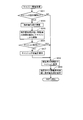
- FIG. 12 is a flowchart of a sub-processing program for cache management processing.
- the CPU 51 determines whether or not the free capacity of the cache 47 is equal to or less than a threshold value.
- the threshold value is the maximum size of the movement guide information 26 that may be acquired from the server device 3 at a time.
- the CPU 51 stores the movement guide information 26 received from the server device 3 in the cache 47.
- the travel guidance information 26 stored in the cache 47 is used for the subsequent specification of the current position in the communication terminal 5, simple travel guidance along the guidance route, and display of images.
- the CPU 51 sets the remaining priority for each area section for the travel guidance information 26 newly stored in the cache 47 in S52.
- the remaining priority is information for selecting the movement guide information 26 to be deleted when the storage area of the cache 47 is insufficient. Specifically, the travel guidance information 26 stored in the cache 47 is preferentially deleted from the one with the low remaining priority.
- the CPU 51 determines the area section where the travel guidance information 26 is required for future vehicle travel guidance, more specifically, “area section located around the current position of the vehicle” and “communication terminal 5”. Each “area section located around the set guide route” is specified. And the remaining priority of the movement guidance information 26 of the specified area section is set higher than the remaining priority of the movement guidance information 26 of other area sections.
- the movement guidance information 26 newly stored in the cache 47 in S52 is the movement guidance of the area section located around the current position of the vehicle or the area section located around the guide route set in the communication terminal 5. Information 26 is obtained. Therefore, in S53, the remaining priority is basically set to “A (high)”.
- the CPU 51 updates the remaining priority set for each travel guide information 26 stored in the cache 47 for each area section.
- the movement guide information 26 stored in the cache 47 has a remaining priority set for each section (for example, mesh unit) of the map information as shown in FIG.
- the CPU 51 updates the remaining priority according to the following conditions (1) and (2).
- Area section located around the current position of the vehicle for example, 3 ⁇ 3 mesh centered on the current position of the vehicle
- area section located around the guide route set by the communication terminal 5 for example, The remaining priority is set to “A (high)” for the travel guidance information 26 of the mesh) including the guide route because it is highly likely to be required for future vehicle travel guidance.
- the remaining priority is set to “B (low)”.
- the area section in which the version of the terminal-side map information 48 is the latest version that is, the travel based on the latest version of the map information even if the communication terminal 5 does not use the movement guide information 26.
- the remaining priority is set to “B (low)” for the movement guidance information 26 of the area sections where guidance can be performed.
- the CPU 51 preferentially deletes the travel guide information 26 stored in the cache 47 from the ones with the low remaining priority. Specifically, the travel guide information 26 whose remaining priority is set to “B (low)” is deleted from the cache in units of area sections (mesh).
- the CPU 51 determines again whether or not the free capacity of the cache 47 is equal to or less than the threshold value.
- the CPU 51 temporarily increases the storage capacity allocated to the cache 47 in the hard disk or memory.
- the increased capacity is a capacity in which the free capacity of the cache 47 after the increase is larger than the threshold value that is the determination criterion in S51.
- the increased cache capacity may be restored to the original when the free area of the cache 47 subsequently increases, or may not be restored. Thereafter, the process proceeds to S52.
- the communication terminal 5 sets the destination.
- the update target area which is an area in which the terminal-side map information 48 of the communication terminal 5 becomes the map information of the old version with respect to the apparatus-side map information 25 of the server device 3.
- S6, S17, S22 requesting movement guidance information 26 for performing movement guidance of the moving body from the server device 3 for at least the update target area around the current position (S7, S18, S23) Accordingly, the moving body is guided using the movement guide information 26 transmitted from the server device 3 (S15).
- map information (including facility data and data used for route search in addition to the travel guidance information 26 for performing vehicle travel guidance) is used to provide vehicle travel guidance.
- the movement guidance information 26 is acquired from the server device 3 in advance and the movement guidance of the vehicle is performed (S15).
- the amount of data of the travel guidance information 26 is smaller than that of the map information, when acquiring a new version of map information for performing vehicle travel guidance (or for updating the map information to a new version).
- the amount of information distribution can be reduced as compared with the case of obtaining update information.
- the schematic configuration of the movement guide system 1 according to the second embodiment is substantially the same as that of the movement guide system 1 according to the first embodiment.
- Various control processes are also substantially the same as those in the movement guide system 1 according to the first embodiment.
- the travel guidance system 1 in the first embodiment requests the travel guidance information to the server device 3 on the condition that the destination is set in the communication terminal 5, whereas the travel guidance system 1 in the second embodiment.
- the travel guidance system 1 according to the first embodiment is that the travel guidance information is requested to the server device 3 on the condition that a route search request is transmitted from the communication terminal 5 to the server device 3. 1 and different.
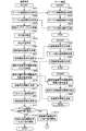
- FIGS. 13 and 14 are flowcharts of the travel guidance processing program according to the second embodiment.
- steps S61 to S65 are the same as steps S1 to S5 of the travel guidance processing program (FIG. 6) according to the first embodiment, and a description thereof will be omitted.
- the CPU 51 performs route search processing from the departure point to the destination set in S64 using the terminal-side map information 48 of the communication terminal 5, and a recommended route (from the departure point to the destination ( Identify the recommended terminal route.
- the details are the same as in S10, and will be omitted.
- the CPU 51 transmits to the server device 3 a route search request for requesting a route search from the departure point to the destination.
- the route search request the terminal ID that identifies the communication terminal 5 that is the transmission source of the route search request, the departure place (for example, the current position of the vehicle) that is the search condition for the route search, and the purpose set in S64 Information specifying the ground and route information specifying the terminal recommended route searched in S66 are included.
- the destination is basically the same as that at the previous search, and therefore information specifying the destination may not be transmitted.
- the CPU 51 specifies “an update target area around the current position of the vehicle” based on the update area table 49 and the current position of the vehicle specified in S65. Details are the same as in S6, and will be omitted.
- the CPU 51 transmits to the server device 3 a request for the travel guidance information 26 for the “update target area around the current position of the vehicle” specified in S ⁇ b> 68.
- the travel guidance information 26 corresponds to the latest version of the map information of the server device 3 and specifies the current position, simple travel guidance along the guidance route, and image display in the communication terminal 5.
- the request for travel guidance information transmitted in S69 includes the terminal ID that identifies the communication terminal 5 that has transmitted the request for travel guidance information, and the area that is the target for requesting travel guidance information (specified in S68). Information (for example, mesh identification number) for specifying “updated area around current position of vehicle”).
- the CPU 51 receives the movement guide information 26 transmitted from the server device 3 in response to the request for the movement guide information 26.
- the travel guidance information 26 is necessary for matching data necessary for map matching of the vehicle and guidance for causing the vehicle to travel along a guidance route such as a left / right turn guidance at a guidance intersection. It includes guidance data and display data for displaying a map image and a guidance screen. That is, the movement guide information 26 received in S70 is information for specifying the current position, simple traveling guidance along the guide route, and displaying an image in the update target area around the current position of the vehicle.
- the processing of S70 is not necessarily performed before the processing of S71 and the following steps, and is performed at the timing when the travel guide information 26 is transmitted from the server device 3. Therefore, if the timing at which the travel guide information 26 is transmitted from the server device 3 is delayed, it may be performed during or after the processing of S71. However, in order to prevent the movement guidance based on the guidance route from being performed or the occurrence of an erroneous guidance event, the transmission of the travel guidance information (S70) precedes the reception of the searched route information (S72). It is desirable to be carried out. The same applies to S79 and S84 described later.
- the CPU 51 performs the cache management process (FIG. 12) shown in FIG.
- the cache management process the travel guide information 26 acquired from the server device 3 as described above is stored in the cache 47 of the communication terminal 5 and unnecessary information is deleted from the cache 47.
- the CPU 51 receives the searched route information transmitted from the server device 3 in response to the route search request.
- the searched route information received in S72 is the purpose from the departure point searched by the server device 3 using the device side map information 25 which is the latest version of map information based on the route search request transmitted in S67. This is information related to the recommended route (server recommended route) to the ground.
- steps S73 to S86 are the same as steps S13 to S26 of the travel guidance processing program (FIGS. 6 and 7) according to the first embodiment, and thus description thereof is omitted.
- the movement guidance processing program executed by the CPU 21 of the server device 3 is the same processing as the movement guidance processing program (FIGS. 6 and 7) according to the first embodiment, and the description thereof will be omitted.
- the processes of S91 to S93, S94 to S96, S97 to S99, S100 to S102, and S103 to S105 are started at the timing when the corresponding information from the communication terminal 5 is received, and are performed in parallel. Therefore, the execution order of the steps is not necessarily executed in the order of the smaller step numbers.
- the transmission of the travel guidance information (S99) precedes the transmission of the searched route information (S96). It is desirable to be carried out.
- the communication terminal 5 is connected to the server device 3.
- the update target area is an area in which the terminal-side map information 48 of the communication terminal 5 becomes the old version of map information with respect to the device-side map information 25 of the server device 3 Is specified (S68), and at least the update target area around the current position is requested
- the server apparatus 3 requests the movement guide information 26 for guiding the moving body (S69), and the server apparatus 3 is requested in response to the request.
- the movement guidance information 26 transmitted from the vehicle is used to guide the movement of the moving body (S75).
- the movement guidance of the moving body is obtained.
- the movement guidance based on the guidance route may not be performed or an erroneous guidance may occur. This can be prevented as much as possible.
- the map information possessed by the communication terminal 5 is an older version of the map information than the map information possessed by the server device 3, it is possible to appropriately guide the moving body based on the guidance route searched by the server device 3. Can be performed.
- the communication terminal 5 performs the processing related to the specification of the update target area around the current position of the vehicle and around the guide route in S6, S17, S22, S68, S77, and S82.
- the server device 3 may be configured by the server device 3. In that case, it is necessary for the server device 3 to have or obtain from the communication terminal 5 the update area table 49, the current position of the vehicle, and the guidance route set in the communication terminal 5.
- the communication terminal 5 requests the travel guidance information 26 from the server device 3 for the update target area around the current position of the vehicle and the update target area around the guide route.
- the server device 3 may request the travel guidance information 26 for the update target area in the area where the map image is displayed on the liquid crystal display 35.
- the map image displayed on the liquid crystal display 35 is scroll-displayed, the map image based on the latest version of the map information can be displayed.
- the remaining priority set in the movement guidance information 26 is updated immediately before the movement guidance information is deleted from the cache 47 (S54).
- the update may be performed, for example, at a predetermined time interval, when the communication terminal 5 is activated, or when the vehicle straddles the mesh.
- the same movement guidance information 26 is already stored in the cache 47 of the communication terminal 5. Are excluded from the target of request, but may be included in the target of request.
- the communication terminal 5 requests the server device 3 for movement guidance information about the update target area around the guidance route, a predetermined distance from the current position of the vehicle to the destination direction.
- the mesh including at least a part of the guide route within L is the target, the mesh including at least a part of the guide route may be the target regardless of the distance from the current position of the vehicle.
- the update area table 49 is a table that identifies a mesh corresponding to the update target area and a mesh not corresponding to the update target area in units of meshes of the map information (FIG. 4). However, it may be identified not in units of meshes but in units of administrative divisions such as municipalities.
- the movement guide information 26 is information divided in units of meshes of map information (FIG. 5), but the movement guide information 26 is not in units of meshes, for example, municipalities.
- the information may be classified by administrative division. Further, when the remaining priority is set for the movement guide information 26, it may be set not in units of mesh but also in units of administrative divisions.
- the communication terminal 5 is after the destination setting (S4) and before sending a route search request to the server device 3 (S11).
- the server 3 is requested for the travel guidance information 26 around the current position (S7), but the travel guidance information is requested after the communication terminal 5 is started and before the guide route is set. It may be performed at the timing.
- the communication terminal can also have the following structures, in that case The effect of.
- the first configuration is as follows. Connected to the server device (3) so as to be capable of two-way communication, and transmits a route search request to the destination to the server device, and obtains a route searched and distributed in the server device in response to the route search request A communication terminal (5) that performs destination setting or transmission of the route search request to the server device, and the terminal side of the communication terminal with respect to device-side map information (25) of the server device Guidance information for performing movement guidance of the moving body from the server device for at least the update target area around the current position in the update target area, which is the area where the map information (48) is an old version of map information.
- the second configuration is as follows.
- the update target area is specified based on area identification information (49) that identifies a partition corresponding to the update target area and a partition not corresponding to the update target area for each partition unit of the map information.
- area identification information (49) that identifies a partition corresponding to the update target area and a partition not corresponding to the update target area for each partition unit of the map information.
- the third configuration is as follows.
- the update target area is specified on a mesh basis. According to the communication terminal having the above-described configuration, by specifying the update target area in the same mesh unit as the map information management section, it is possible to more easily perform the process related to the specification of the update target area and the accompanying guidance information request. Is possible.
- the fourth configuration is as follows.
- the guidance information request means (33) requests the guidance information (26) from the server device (3) for the update target area around the current position and the guidance route.
- the communication terminal having the above-described configuration, it becomes possible to obtain guidance information from the server device for an area where the mobile body may move in the future, that is, an area where guidance information is required.
- the map information possessed by is an older version of map information than the map information possessed by the server device, it is possible to appropriately perform the movement guidance of the mobile body by using the guidance information.
Landscapes
- Engineering & Computer Science (AREA)
- Remote Sensing (AREA)
- Radar, Positioning & Navigation (AREA)
- Physics & Mathematics (AREA)
- General Physics & Mathematics (AREA)
- Theoretical Computer Science (AREA)
- Automation & Control Theory (AREA)
- Databases & Information Systems (AREA)
- Mathematical Physics (AREA)
- Business, Economics & Management (AREA)
- Educational Administration (AREA)
- Educational Technology (AREA)
- Computer Networks & Wireless Communication (AREA)
- Signal Processing (AREA)
- Life Sciences & Earth Sciences (AREA)
- Atmospheric Sciences (AREA)
- Biodiversity & Conservation Biology (AREA)
- Ecology (AREA)
- Environmental & Geological Engineering (AREA)
- Environmental Sciences (AREA)
- Data Mining & Analysis (AREA)
- General Engineering & Computer Science (AREA)
- Navigation (AREA)
- Instructional Devices (AREA)
Abstract
L'invention concerne : un terminal de communication qui empêche autant que possible l'apparition d'un guidage erroné, et des événements dans lesquels un guidage de mouvement basé sur un itinéraire de guidage n'est pas effectué, après que le terminal de communication a acquis l'itinéraire de guidage à partir d'un dispositif serveur ; un dispositif serveur ; un système de guidage de mouvement ; et un programme informatique. Plus précisément, le terminal de communication (5) identifie des zones à mettre à jour, c'est-à-dire des zones qui représentent des fragments d'informations cartographiques d'ancienne version dans des informations cartographiques côté terminal (48) du terminal de communication (5) par rapport à des informations cartographiques côté dispositif (25) d'un dispositif serveur (3), demande au dispositif serveur (3), concernant au moins les zones à mettre à jour autour de la position actuelle, des informations de guidage de mouvement (26) pour guider le mouvement d'un corps mobile, et utilise les informations de guidage de mouvement (26) transmises par le dispositif serveur (3) conformément à la requête pour guider le mouvement du corps mobile.
Priority Applications (4)
| Application Number | Priority Date | Filing Date | Title |
|---|---|---|---|
| JP2018509189A JP6752269B2 (ja) | 2016-03-28 | 2017-03-23 | 通信端末、サーバ装置、移動案内システム及びコンピュータプログラム |
| EP17774680.7A EP3385675A4 (fr) | 2016-03-28 | 2017-03-23 | Terminal de communication, dispositif serveur, système de guidage de mouvement, et programme informatique |
| CN201780017640.5A CN108885116B (zh) | 2016-03-28 | 2017-03-23 | 通信终端、服务器装置、移动引导系统以及计算机程序 |
| US16/080,509 US10935390B2 (en) | 2016-03-28 | 2017-03-23 | Communication terminal, server device, movement guidance system, and computer program |
Applications Claiming Priority (2)
| Application Number | Priority Date | Filing Date | Title |
|---|---|---|---|
| JP2016-064276 | 2016-03-28 | ||
| JP2016064276 | 2016-03-28 |
Publications (1)
| Publication Number | Publication Date |
|---|---|
| WO2017170142A1 true WO2017170142A1 (fr) | 2017-10-05 |
Family
ID=59964415
Family Applications (1)
| Application Number | Title | Priority Date | Filing Date |
|---|---|---|---|
| PCT/JP2017/011780 Ceased WO2017170142A1 (fr) | 2016-03-28 | 2017-03-23 | Terminal de communication, dispositif serveur, système de guidage de mouvement, et programme informatique |
Country Status (5)
| Country | Link |
|---|---|
| US (1) | US10935390B2 (fr) |
| EP (1) | EP3385675A4 (fr) |
| JP (1) | JP6752269B2 (fr) |
| CN (1) | CN108885116B (fr) |
| WO (1) | WO2017170142A1 (fr) |
Families Citing this family (6)
| Publication number | Priority date | Publication date | Assignee | Title |
|---|---|---|---|---|
| US10935390B2 (en) | 2016-03-28 | 2021-03-02 | Aisin Aw Co., Ltd. | Communication terminal, server device, movement guidance system, and computer program |
| JP6718715B2 (ja) | 2016-03-28 | 2020-07-08 | アイシン・エィ・ダブリュ株式会社 | 通信端末、サーバ装置、移動案内システム及びコンピュータプログラム |
| JP6813347B2 (ja) | 2016-12-12 | 2021-01-13 | アイシン・エィ・ダブリュ株式会社 | 通信端末、移動案内システム及びコンピュータプログラム |
| EP3933536A4 (fr) * | 2019-02-25 | 2022-11-02 | Murata Machinery, Ltd. | Véhicule en déplacement et système de véhicule en déplacement |
| US11017347B1 (en) | 2020-07-09 | 2021-05-25 | Fourkites, Inc. | Supply chain visibility platform |
| CN113899355A (zh) * | 2021-08-25 | 2022-01-07 | 上海钧正网络科技有限公司 | 地图更新方法、装置、云端服务器和共享骑行设备 |
Citations (1)
| Publication number | Priority date | Publication date | Assignee | Title |
|---|---|---|---|---|
| JP2003195743A (ja) * | 2001-12-25 | 2003-07-09 | Aisin Aw Co Ltd | 地図表示システム、地図表示装置、及び地図表示プログラム |
Family Cites Families (37)
| Publication number | Priority date | Publication date | Assignee | Title |
|---|---|---|---|---|
| JPH1165436A (ja) | 1997-08-21 | 1999-03-05 | Toyota Motor Corp | 地図データ選択支援装置、その支援装置を含む地図データ処理システムおよび処理装置 |
| JP4566413B2 (ja) | 2001-01-10 | 2010-10-20 | 三菱電機株式会社 | 地図情報処理装置 |
| JP4380097B2 (ja) | 2001-08-23 | 2009-12-09 | 三菱電機株式会社 | 地図情報更新システム、地図情報処理装置及び地図情報提供装置 |
| JP4603735B2 (ja) * | 2001-08-31 | 2010-12-22 | パイオニア株式会社 | 通信型ナビゲーション装置およびサーバ装置 |
| JP2003075174A (ja) * | 2001-08-31 | 2003-03-12 | Pioneer Electronic Corp | 通信型ナビゲーション装置およびサーバ装置 |
| EP1288625B1 (fr) | 2001-08-31 | 2011-07-27 | Pioneer Corporation | Appareil de navigation de type communication et serveur |
| US6970786B2 (en) | 2001-12-25 | 2005-11-29 | Aisin Aw Co., Ltd. | Method for transmitting map data and map display apparatus and system |
| WO2004008073A1 (fr) | 2002-07-17 | 2004-01-22 | Xanavi Informatics Corporation | Methode de navigation, methode de traitement pour systeme de navigation, dispositif et programme de gestion de donnees cartographiques et programme informatique |
| CN100507450C (zh) * | 2002-09-24 | 2009-07-01 | 三洋电机株式会社 | 导航设备和服务器设备 |
| JP2004309705A (ja) * | 2003-04-04 | 2004-11-04 | Pioneer Electronic Corp | 地図情報処理装置、そのシステム、その方法、そのプログラム、および、そのプログラムを記録した記録媒体 |
| KR100539834B1 (ko) * | 2003-06-30 | 2005-12-28 | 엘지전자 주식회사 | 차량 항법 유도 장치를 이용한 지도 버전 관리 방법 및시스템 |
| US7373244B2 (en) | 2004-04-20 | 2008-05-13 | Keith Kreft | Information mapping approaches |
| US20070244636A1 (en) * | 2004-07-16 | 2007-10-18 | Matsushita Electric Industrial Co., Ltd. | Map Update System |
| JP5183029B2 (ja) | 2006-03-10 | 2013-04-17 | 日立オートモティブシステムズ株式会社 | 地図更新プログラム及び地図更新端末 |
| JP4774555B2 (ja) * | 2006-08-02 | 2011-09-14 | パイオニア株式会社 | 経路探索システム、経路探索用データのデータ構造、サーバ装置、端末装置及びサーバ装置用プログラム、端末装置用プログラム並びに経路探索方法 |
| JP4694443B2 (ja) | 2006-08-17 | 2011-06-08 | 本田技研工業株式会社 | ナビサーバ、ナビ装置およびナビシステム |
| JP5001617B2 (ja) | 2006-09-29 | 2012-08-15 | アイシン・エィ・ダブリュ株式会社 | 地図更新データ供給装置、バージョンテーブル、地図データ更新システム、地図更新データ供給プログラム、及び地図データ更新プログラム |
| US8521430B2 (en) * | 2007-12-28 | 2013-08-27 | Navteq B.V. | Managing differences between geographic database versions |
| JP4993761B2 (ja) | 2008-06-02 | 2012-08-08 | アイシン・エィ・ダブリュ株式会社 | 地図情報管理システム、地図情報管理方法及び車載用地図情報管理装置 |
| CN102057251B (zh) * | 2008-06-04 | 2012-11-14 | 株式会社日立制作所 | 导航装置、导航方法及导航系统 |
| JP5752357B2 (ja) | 2009-02-13 | 2015-07-22 | アイシン・エィ・ダブリュ株式会社 | ナビゲーション装置及び地図情報更新方法 |
| JP5353291B2 (ja) * | 2009-02-19 | 2013-11-27 | ソニー株式会社 | 案内経路配信装置、案内経路配信方法及び案内経路配信プログラム |
| JP5316292B2 (ja) * | 2009-07-31 | 2013-10-16 | アイシン・エィ・ダブリュ株式会社 | 地図情報案内装置、地図情報案内方法及びコンピュータプログラム |
| WO2011016117A1 (fr) * | 2009-08-05 | 2011-02-10 | 株式会社ナビタイムジャパン | Système de guidage par itinéraire, serveur de guidage par itinéraire, serveur dintermédiation de guidage par itinéraire et procédé de guidage par itinéraire |
| JP5689593B2 (ja) | 2009-09-24 | 2015-03-25 | 株式会社東芝 | 地図情報処理装置及びプログラム |
| JP5426295B2 (ja) | 2009-09-24 | 2014-02-26 | 株式会社東芝 | 地図情報処理装置及びプログラム |
| JP5361648B2 (ja) | 2009-10-02 | 2013-12-04 | アルパイン株式会社 | ナビゲーション装置およびルート表示方法 |
| WO2011048628A1 (fr) * | 2009-10-21 | 2011-04-28 | 三菱電機株式会社 | Processeur d'informations cartographiques |
| EP2543963B1 (fr) * | 2011-07-08 | 2020-05-13 | Harman Becker Automotive Systems GmbH | Procédé pour actualiser une base de données d'un dispositif de navigation et dispositif de navigation associé |
| EP2589931B1 (fr) * | 2011-11-07 | 2016-06-29 | Elektrobit Automotive GmbH | Technique pour structurer les données de navigation |
| JP5826290B2 (ja) | 2012-01-05 | 2015-12-02 | 三菱電機株式会社 | 地図表示制御装置およびこれを用いたナビゲーション装置 |
| JP5625004B2 (ja) * | 2012-02-03 | 2014-11-12 | クラリオン株式会社 | ナビゲーションシステムおよび経路探索方法 |
| KR102107123B1 (ko) * | 2014-01-28 | 2020-05-06 | 현대엠엔소프트 주식회사 | 내비게이션 자동 업데이트 장치 및 방법 |
| JP6476870B2 (ja) | 2015-01-07 | 2019-03-06 | アイシン・エィ・ダブリュ株式会社 | 移動案内装置、移動案内装置の地図情報更新方法及びコンピュータプログラム |
| JP6559535B2 (ja) * | 2015-10-22 | 2019-08-14 | 株式会社東芝 | 障害物マップ生成装置、その方法、及び、そのプログラム |
| US10935390B2 (en) | 2016-03-28 | 2021-03-02 | Aisin Aw Co., Ltd. | Communication terminal, server device, movement guidance system, and computer program |
| JP6813347B2 (ja) | 2016-12-12 | 2021-01-13 | アイシン・エィ・ダブリュ株式会社 | 通信端末、移動案内システム及びコンピュータプログラム |
-
2017
- 2017-03-23 US US16/080,509 patent/US10935390B2/en active Active
- 2017-03-23 CN CN201780017640.5A patent/CN108885116B/zh active Active
- 2017-03-23 JP JP2018509189A patent/JP6752269B2/ja active Active
- 2017-03-23 EP EP17774680.7A patent/EP3385675A4/fr not_active Withdrawn
- 2017-03-23 WO PCT/JP2017/011780 patent/WO2017170142A1/fr not_active Ceased
Patent Citations (1)
| Publication number | Priority date | Publication date | Assignee | Title |
|---|---|---|---|---|
| JP2003195743A (ja) * | 2001-12-25 | 2003-07-09 | Aisin Aw Co Ltd | 地図表示システム、地図表示装置、及び地図表示プログラム |
Also Published As
| Publication number | Publication date |
|---|---|
| CN108885116A (zh) | 2018-11-23 |
| JPWO2017170142A1 (ja) | 2019-01-10 |
| EP3385675A1 (fr) | 2018-10-10 |
| CN108885116B (zh) | 2022-04-29 |
| EP3385675A4 (fr) | 2018-12-19 |
| US20190063946A1 (en) | 2019-02-28 |
| JP6752269B2 (ja) | 2020-09-09 |
| US10935390B2 (en) | 2021-03-02 |
Similar Documents
| Publication | Publication Date | Title |
|---|---|---|
| CN108225347B (zh) | 通信终端、移动引导系统以及移动引导方法 | |
| CN108779988B (zh) | 通信终端、服务器装置、移动引导系统以及计算机程序 | |
| JP6752269B2 (ja) | 通信端末、サーバ装置、移動案内システム及びコンピュータプログラム | |
| JP6664469B2 (ja) | 通信端末、経路探索システム及びコンピュータプログラム | |
| JP6646731B2 (ja) | サーバ装置、通信端末、経路探索システム及びコンピュータプログラム | |
| JP6747098B2 (ja) | サーバ装置、通信端末、情報配信システム及びコンピュータプログラム | |
| JP6834693B2 (ja) | 通信端末、移動案内システム及びコンピュータプログラム | |
| JP6630818B2 (ja) | 移動案内装置及びコンピュータプログラム | |
| JP6747097B2 (ja) | サーバ装置及びコンピュータプログラム | |
| JP2018119909A (ja) | 通信端末、経路探索システム及びコンピュータプログラム | |
| JP2019138726A (ja) | 通信端末、移動案内システム及びコンピュータプログラム | |
| JP2019120489A (ja) | 通信端末、移動案内システム及びコンピュータプログラム |
Legal Events
| Date | Code | Title | Description |
|---|---|---|---|
| WWE | Wipo information: entry into national phase |
Ref document number: 2018509189 Country of ref document: JP |
|
| WWE | Wipo information: entry into national phase |
Ref document number: 2017774680 Country of ref document: EP |
|
| ENP | Entry into the national phase |
Ref document number: 2017774680 Country of ref document: EP Effective date: 20180704 |
|
| NENP | Non-entry into the national phase |
Ref country code: DE |