WO2024195065A1 - Dispositif d'aide à la conduite, procédé d'aide à la conduite et support d'enregistrement - Google Patents
Dispositif d'aide à la conduite, procédé d'aide à la conduite et support d'enregistrement Download PDFInfo
- Publication number
- WO2024195065A1 WO2024195065A1 PCT/JP2023/011319 JP2023011319W WO2024195065A1 WO 2024195065 A1 WO2024195065 A1 WO 2024195065A1 JP 2023011319 W JP2023011319 W JP 2023011319W WO 2024195065 A1 WO2024195065 A1 WO 2024195065A1
- Authority
- WO
- WIPO (PCT)
- Prior art keywords
- vehicle
- information
- area
- moving object
- road
- Prior art date
- Legal status (The legal status is an assumption and is not a legal conclusion. Google has not performed a legal analysis and makes no representation as to the accuracy of the status listed.)
- Ceased
Links
Images




Classifications
-
- G—PHYSICS
- G06—COMPUTING OR CALCULATING; COUNTING
- G06V—IMAGE OR VIDEO RECOGNITION OR UNDERSTANDING
- G06V20/00—Scenes; Scene-specific elements
- G06V20/50—Context or environment of the image
- G06V20/56—Context or environment of the image exterior to a vehicle by using sensors mounted on the vehicle
-
- B—PERFORMING OPERATIONS; TRANSPORTING
- B60—VEHICLES IN GENERAL
- B60W—CONJOINT CONTROL OF VEHICLE SUB-UNITS OF DIFFERENT TYPE OR DIFFERENT FUNCTION; CONTROL SYSTEMS SPECIALLY ADAPTED FOR HYBRID VEHICLES; ROAD VEHICLE DRIVE CONTROL SYSTEMS FOR PURPOSES NOT RELATED TO THE CONTROL OF A PARTICULAR SUB-UNIT
- B60W40/00—Estimation or calculation of non-directly measurable driving parameters for road vehicle drive control systems not related to the control of a particular sub unit, e.g. by using mathematical models
- B60W40/02—Estimation or calculation of non-directly measurable driving parameters for road vehicle drive control systems not related to the control of a particular sub unit, e.g. by using mathematical models related to ambient conditions
-
- B—PERFORMING OPERATIONS; TRANSPORTING
- B60—VEHICLES IN GENERAL
- B60W—CONJOINT CONTROL OF VEHICLE SUB-UNITS OF DIFFERENT TYPE OR DIFFERENT FUNCTION; CONTROL SYSTEMS SPECIALLY ADAPTED FOR HYBRID VEHICLES; ROAD VEHICLE DRIVE CONTROL SYSTEMS FOR PURPOSES NOT RELATED TO THE CONTROL OF A PARTICULAR SUB-UNIT
- B60W50/00—Details of control systems for road vehicle drive control not related to the control of a particular sub-unit, e.g. process diagnostic or vehicle driver interfaces
- B60W50/08—Interaction between the driver and the control system
- B60W50/14—Means for informing the driver, warning the driver or prompting a driver intervention
-
- G—PHYSICS
- G01—MEASURING; TESTING
- G01C—MEASURING DISTANCES, LEVELS OR BEARINGS; SURVEYING; NAVIGATION; GYROSCOPIC INSTRUMENTS; PHOTOGRAMMETRY OR VIDEOGRAMMETRY
- G01C21/00—Navigation; Navigational instruments not provided for in groups G01C1/00 - G01C19/00
- G01C21/26—Navigation; Navigational instruments not provided for in groups G01C1/00 - G01C19/00 specially adapted for navigation in a road network
- G01C21/28—Navigation; Navigational instruments not provided for in groups G01C1/00 - G01C19/00 specially adapted for navigation in a road network with correlation of data from several navigational instruments
- G01C21/30—Map- or contour-matching
-
- G—PHYSICS
- G06—COMPUTING OR CALCULATING; COUNTING
- G06V—IMAGE OR VIDEO RECOGNITION OR UNDERSTANDING
- G06V20/00—Scenes; Scene-specific elements
- G06V20/50—Context or environment of the image
- G06V20/52—Surveillance or monitoring of activities, e.g. for recognising suspicious objects
- G06V20/54—Surveillance or monitoring of activities, e.g. for recognising suspicious objects of traffic, e.g. cars on the road, trains or boats
-
- G—PHYSICS
- G06—COMPUTING OR CALCULATING; COUNTING
- G06V—IMAGE OR VIDEO RECOGNITION OR UNDERSTANDING
- G06V20/00—Scenes; Scene-specific elements
- G06V20/50—Context or environment of the image
- G06V20/56—Context or environment of the image exterior to a vehicle by using sensors mounted on the vehicle
- G06V20/58—Recognition of moving objects or obstacles, e.g. vehicles or pedestrians; Recognition of traffic objects, e.g. traffic signs, traffic lights or roads
-
- G—PHYSICS
- G08—SIGNALLING
- G08G—TRAFFIC CONTROL SYSTEMS
- G08G1/00—Traffic control systems for road vehicles
- G08G1/01—Detecting movement of traffic to be counted or controlled
- G08G1/04—Detecting movement of traffic to be counted or controlled using optical or ultrasonic detectors
-
- G—PHYSICS
- G08—SIGNALLING
- G08G—TRAFFIC CONTROL SYSTEMS
- G08G1/00—Traffic control systems for road vehicles
- G08G1/16—Anti-collision systems
-
- G—PHYSICS
- G08—SIGNALLING
- G08G—TRAFFIC CONTROL SYSTEMS
- G08G1/00—Traffic control systems for road vehicles
- G08G1/16—Anti-collision systems
- G08G1/166—Anti-collision systems for active traffic, e.g. moving vehicles, pedestrians, bikes
-
- G—PHYSICS
- G08—SIGNALLING
- G08G—TRAFFIC CONTROL SYSTEMS
- G08G1/00—Traffic control systems for road vehicles
- G08G1/16—Anti-collision systems
- G08G1/167—Driving aids for lane monitoring, lane changing, e.g. blind spot detection
-
- G—PHYSICS
- G06—COMPUTING OR CALCULATING; COUNTING
- G06V—IMAGE OR VIDEO RECOGNITION OR UNDERSTANDING
- G06V2201/00—Indexing scheme relating to image or video recognition or understanding
- G06V2201/08—Detecting or categorising vehicles
Definitions
- This disclosure relates to a driving assistance device, a driving assistance method, and a recording medium.
- the vehicle being assisted acquires information detected by sensors or cameras of vehicles other than the vehicle being assisted using vehicle-to-vehicle communication means or road-to-vehicle communication means, and issues a warning to the driver, etc.
- Patent Document 1 proposes an image display device that uses vehicle-to-vehicle communication to complement blind spots created by a vehicle ahead.
- the image display device described in Patent Document 1 receives an image captured by a camera on a vehicle ahead via a communication device, converts the received image into an image that would be displayed if the camera's setting position was changed to the driver's viewpoint position, and displays this viewpoint-converted image data on the windshield by a head-up display.
- the image display device displays a marker on the windshield, and when the driver focuses on the marker, the marker image formed on the cornea is detected by an eye-photographing camera, and displays the viewpoint-converted image data when this marker image is detected.
- Patent Document 2 also proposes a nearby moving object display that detects approaching moving objects in the blind spot of the vehicle and displays this information to the driver.
- Patent Document 2 discloses a technology in which a camera repeatedly captures images of road traffic conditions, recognizes moving objects moving on the road based on the image information captured by the camera, calculates a virtual display position of the moving object on a screen from position information of the recognized moving object, displays the calculated virtual display position of the moving object on a screen inside the vehicle, and brings the displayed virtual display position of the moving object closer to the actual display position of the moving object on the screen.
- Patent Document 3 proposes a display device that can reduce the sense of incongruity of the display when visualizing blind spots.
- a display device that includes an object information acquisition means for acquiring object information, which is information about objects present in the scenery ahead and indicates at least the position of the objects, an identification means for identifying a blind spot object that is in the driver's blind spot and a forward object that is a cause of the blind spot based on the object information, and a display control means for controlling the display of a superimposed image, and when a blind spot object is identified, the display control means controls the display position so that display content including a blind spot object image indicating the blind spot object is visible at the position of the blind spot object.
- Patent Documents 1 to 3 that informs the driver of the situation in the blind spot area that is the blind spot from the driver's perspective, the driver may become overconfident in the function of informing the driver of the situation in the blind spot area, which may reduce the driver's sense of danger regarding the blind spot area and increase the risk.
- information on the recognition area recognized by other vehicles other than the vehicle to be assisted or cameras installed on the road, etc. is not shared with the vehicle to be assisted.
- This disclosure has been made in consideration of the above circumstances, and the purpose of this disclosure is to provide a driving assistance device, a driving assistance method, and a recording medium that can reduce the risk of colliding with a moving object caused by overconfidence in the function that notifies the driver of the situation in the blind spot.
- a driving assistance device that assists in driving a vehicle
- the driving assistance device comprising one or more processors and one or more memories communicatively connected to the one or more processors, the one or more processors executing a process of acquiring at least recognition area information and measurement result information from at least one environmental recognition device outside the vehicle, and a process of superimposing and displaying the recognition area information and information on the moving object on map data, real space, or a captured image of the real space, when a moving object is detected by the environmental recognition device in an overlapping area between a blind spot area that is a blind spot as seen from the vehicle and the recognition area of the environmental recognition device.
- a driving assistance method includes the steps of: one or more processors acquiring at least recognition area information and measurement result information from at least one environmental recognition device outside the vehicle; and, when a moving object is detected by the environmental recognition device in an overlapping area between a blind spot area that is a blind spot as seen from the vehicle and the recognition area of the environmental recognition device, displaying the recognition area information and information about the moving object in a superimposed manner on map data, real space, or a captured image of the real space.
- a non-transitory tangible recording medium stores a computer program that causes a processor to execute processes including: acquiring at least recognition area information and measurement result information from at least one environmental recognition device outside the vehicle; and, when a moving object is detected by the environmental recognition device in an overlapping area between a blind spot area that is a blind spot as seen from the vehicle and the recognition area of the environmental recognition device, displaying the recognition area information and information about the moving object superimposed on map data, real space, or a captured image of the real space.
- this disclosure makes it possible to reduce the risk of colliding with a moving object caused by overconfidence in the function that notifies the driver of the situation in the blind spot.
- FIG. 1 is a diagram illustrating a configuration example of a driving assistance system according to an embodiment of the present disclosure.
- FIG. 2 is a schematic diagram showing a configuration example of a support target vehicle.
- FIG. 2 is a block diagram showing an example of the configuration of a road camera according to the embodiment.
- 5 is a flowchart showing an example of a processing operation of the road camera.
- FIG. 2 is a block diagram showing a configuration example of a driving assistance device according to the embodiment.
- 4 is a flowchart illustrating an example of a driving assistance method according to the present disclosure.
- FIG. 2 is an explanatory diagram illustrating an example in which the driving support method is applied.
- 10 is a flowchart showing an example of display control of the processing device according to the embodiment.
- FIG. 4 is an explanatory diagram illustrating an example of a display mode of the display device according to the embodiment.
- FIG. 4 is an explanatory diagram illustrating an example of a display mode of the display device according to the embodiment.
- FIG. 4 is an explanatory diagram illustrating an example of a display mode of the display device according to the embodiment.
- FIG. 4 is an explanatory diagram illustrating an example of a display mode of the display device according to the embodiment.
- FIG. 1 is a diagram showing an example of the configuration of a driving assistance system 1.
- the driving assistance system 1 has a vehicle 10 and a road camera 100. There may be a plurality of vehicles 10 and a plurality of road cameras 100. In the following description, the vehicle 10 will be described as a vehicle to be assisted.
- the vehicle 10 has a driving assistance device 11.
- the driving assistance device 11 has one or more processors.
- the road camera 100 is installed on a road, for example, and has a control device 110.
- the control device 110 has one or more processors.
- the road camera 100 is an example of an "environment recognition device.”
- the "environment recognition device” is not limited to the road camera 100, and may be a sensor device (such as LiDAR (Light Detection And Ranging), a radar sensor, or an ultrasonic sensor) provided on the vehicle 10 or another vehicle 20.
- the driving assistance device 11 is configured to be able to communicate with the road cameras 100 via road-to-vehicle communication N1. For example, the driving assistance device 11 identifies road cameras 100 that are present within a predetermined distance from the current position of the vehicle 10, and is connected to the identified road cameras 100 via wireless communication so that they can communicate with each other. The driving assistance device 11 may also be configured to be able to communicate with other vehicles 20 via vehicle-to-vehicle communication N2.
- the vehicle 10 has a sensor device.
- the sensor device may be, for example, one or more of a camera, LiDAR, radar sensor, and ultrasonic sensor.
- the driving assistance device 11 acquires sensor information from each sensor at a predetermined calculation cycle and executes a process to recognize the surrounding environment of the vehicle 10. For example, the driving assistance device 11 recognizes objects present within the detection range of each sensor by the process to recognize the surrounding environment of the vehicle 10.
- the "objects" in question are, for example, moving objects such as vehicles, bicycles, and pedestrians, guardrails, exterior walls, curbs, buildings, roads (for example, roads R1 and R2) and other stationary objects, and boundary lines of driving lanes.
- the road camera 100 is installed on the road or on a building.
- the control device 110 of the road camera 100 acquires information on the image of the detection range at a predetermined calculation cycle.
- the control device 110 transmits information on the recognition area (hereinafter referred to as recognition area information) and information on the measurement results of the road camera 100 (hereinafter referred to as measurement result information) to the driving assistance device 11 at a predetermined calculation cycle.
- the recognition area information includes, for example, information on the installation position of the road camera 100, as well as information on the angle of view, recognition distance, and shooting direction of the road camera 100.
- the "recognition area of the road camera 100" refers to the detection range of the road camera 100, that is, the range in real space that the road camera 100 has captured and as a result recognized as the presence or absence of an object.
- the "recognition area information of the road camera 100" includes information that can identify the detection range when the road camera 100 recognizes the presence or absence of an object in real space.
- Information on the installation position of the road camera 100 is recorded in advance in the control device 110 as coordinate position information indicated by, for example, latitude and longitude.
- Information on the angle of view and shooting direction of the road camera 100 can be expressed as a vector projected onto an XY plane based on the world coordinate system, and this vector information may be recorded in the control device 110.
- Information on the shooting direction of the road camera 100 may be recorded in the control device 110 as information indicating the angle between the extension direction of the movement path near the location where the road camera 100 is installed and the optical axis of the road camera 100.
- Information on the recognition distance of the road camera 100 is recorded in advance in the control device 110 as a distance range within which the control device 110 can recognize objects based on the image information of the road camera 100. Note that the above-mentioned "coordinate position" refers to the two-dimensional coordinate position of an object indicated by latitude and longitude unless otherwise specified, and this also applies to the following explanation.
- FIG. 2 is a schematic diagram showing a configuration example of the vehicle 10.
- the vehicle 10 may be, for example, a two-wheel drive vehicle, or a four-wheel drive vehicle that transmits drive torque to the front and rear wheels.
- the vehicle 10 may be, for example, an electric vehicle equipped with a motor for driving the front wheels and a motor for driving the rear wheels separately, or an electric vehicle having a drive motor corresponding to each wheel.
- the vehicle 10 is an electric vehicle or a hybrid electric vehicle
- the vehicle 10 has a secondary battery and a motor.
- the secondary battery stores electric power supplied to the drive motor.
- the motor outputs the drive force of the vehicle 10.
- the motor also functions as a generator that generates electric power to be charged into the battery during deceleration.
- the vehicle 10 may be equipped with a power generation device such as a fuel cell.
- the vehicle 10 has a driving force source 17, an electric steering device 15, brake devices 13A to 13D, and a vehicle control unit 21. These are used to control the driving of the vehicle 10.
- brake devices 13A to 13D they may be referred to simply as "brake device 13.”
- the driving force source 17 generates a driving torque and transmits the generated driving torque to the left front wheel and the right front wheel.
- the driving force source 17 outputs a driving torque that is transmitted to the front wheel drive shaft F via a transmission (not shown) and a differential mechanism 14.
- the driving of the driving force source 17 and the transmission is controlled by a vehicle control unit 21.
- the driving force source 17 may be an internal combustion engine such as a gasoline engine or a diesel engine, or may be a driving motor.
- the vehicle 10 may also be equipped with both an internal combustion engine and a driving motor as the driving force source 17.
- the electric steering device 15 is provided on the front wheel drive shaft F as shown in FIG. 2.
- the electric steering device 15 has an electric motor (not shown) and a gear mechanism, and adjusts the steering angle of the front wheels based on the control of the vehicle control unit 21.
- Each of the brake devices 13A to 13D applies a braking force to the corresponding wheel.
- the brake device 13 is, for example, a hydraulic brake device.
- the vehicle control unit 21 has one or more electronic control units (ECUs).
- the electronic control units control the driving of the driving force source 17, the electric steering device 15, and the hydraulic unit 22. If the vehicle 10 has a transmission that changes the speed of the output from the driving force source 17 and transmits it to the wheels, the vehicle control unit 21 has a function of controlling the driving of the transmission.
- the vehicle control unit 21 adjusts the hydraulic pressure supplied to each brake device 13 by controlling the drive of the hydraulic unit 22. If the vehicle 10 is an electric vehicle or a hybrid electric vehicle, the brake devices 13 are used in conjunction with regenerative braking using a drive motor.
- the vehicle control unit 21 is configured to be able to acquire information transmitted from the driving assistance device 11, and is configured to be able to execute automatic driving control of the vehicle 10.
- the vehicle control unit 21 controls the electric steering device 15 based on the steering angle of the steering wheel 16, which changes according to the driving operation of the driver.
- the vehicle control unit 21 also controls the electric steering device 15 based on the set steering angle or steering angular speed.
- the vehicle 10 further includes a sensor device 12 and a display device 18.
- the sensor device 12 includes forward-facing cameras 12A and 12B, a rear-facing camera 12C, and a vehicle position detection sensor 12D.
- the front photographing cameras 12A, 12B and the rear photographing camera 12C acquire information on the environment surrounding the vehicle 10.
- the front photographing cameras 12A, 12B photograph the area in front of the vehicle 10 in the direction of travel and generate image information.
- the rear photographing camera 12C photographs the area behind the vehicle 10 in the direction of travel and generate image information.
- the front photographing cameras 12A, 12B and the rear photographing camera 12C have imaging elements such as CCD (Charged Coupled Devices) or CMOS (Complementary Metal Oxide Semiconductor), and transmit the generated image information to the driving assistance device 11.
- the front photographing cameras 12A, 12B are typically stereo cameras including a pair of left and right cameras, but are not limited to this and may be monocular cameras.
- the sensor device 12 may also have a camera (not shown) that is mounted on a side mirror and captures the left or right rear of the vehicle 10.
- the sensor device 12 may have one or more of a radar sensor such as a LiDAR or millimeter-wave radar, and an ultrasonic sensor.
- the sensor device 12 may include a vehicle speed sensor that detects the moving speed of the vehicle 10.
- the vehicle position detection sensor 12D receives satellite signals from positioning satellites of the Global Navigation Satellite System (GNSS), such as the Global Positioning System (GPS) satellites.
- GNSS Global Navigation Satellite System
- GPS Global Positioning System
- the vehicle position detection sensor 12D detects the current position of the vehicle 10 at a predetermined calculation period based on the received satellite signals, and transmits information indicating the detected current position (hereinafter referred to as position information) to the driving assistance device 11.
- position information is indicated, for example, by a coordinate position of latitude and longitude.
- the vehicle position detection sensor 19 may also have an antenna that receives satellite signals from other satellite systems that identify the coordinate position of the vehicle 10.
- the driving assistance device 11 may generate information indicating the direction of movement of the vehicle 10 (hereinafter referred to as movement direction information) and information indicating the movement speed of the vehicle 10 (hereinafter referred to as movement speed information) based on the position information acquired from the vehicle position detection sensor 12D.
- the driving assistance device 11 calculates the movement speed of the vehicle 10, for example, based on a change in the coordinate position of the vehicle 10. Specifically, the driving assistance device 11 calculates the movement speed of the vehicle 10 by dividing the distance from the coordinate position of the vehicle 10 acquired in a calculation cycle before the current position to the coordinate position of the vehicle 10 acquired in the calculation cycle of the current position, by a unit time equivalent to the calculation cycle. In addition, the driving assistance device 11 calculates the movement direction of the vehicle 10 as, for example, the direction in which the coordinate position of the vehicle 10 changes.
- the display device 18 is driven by the driving assistance device 11 and displays various information visible to the driver.
- the display device 18 in this embodiment is typically an AR (Augmented Reality) display device or a HUD (Head Up Display) display device that virtually displays information visible to the driver on the front window or the like by superimposing it on the real space around the vehicle 10, but is not limited to this and may be a display device provided in an instrument panel or a display device of a navigation system.
- the control device 110 has a communication device 111, a processing device 112, and a storage device 113.
- the communication device 111 is an interface for communicating with the vehicle 10 via the road-to-vehicle communication N1.
- the processing device 112 has one or more CPUs (Central Processing Units) such as a GPU (Graphics Processing Unit).
- the processing device 112 executes a computer program stored in the storage device 113 to transmit to the vehicle 10 measurement result information indicating a measurement result based on image information transmitted from the image generation unit 120 at a predetermined calculation cycle.
- the storage device 113 has one or more memories, and stores computer programs executed by the processing device 112, various parameters used in the calculation process, and information on the results of the calculation. A part of the storage device 113 is used as a work area for the processing device 112.
- the storage device 113 may be a magnetic medium such as a hard disk, a floppy disk, or a magnetic tape, an optical recording medium such as a CD-ROM (Compact Disk Read Only Memory), a DVD (Digital Versatile Disk), or a Blu-ray (registered trademark), a magnetic optical medium such as a floptical disk, a memory element such as a RAM (Random Access Memory) or a ROM (Read Only Memory), a flash memory such as a USB (Universal Serial Bus) memory or an SSD (Solid State Drive), or any other recording medium.
- the storage device 113 stores the recognition area information and the measurement result information.
- the processing device 112 has an image processing section 112A and a communication control section 112B. The functions of these sections are realized by the execution of a computer program by the processor.
- the image processing section 112A executes a surrounding environment recognition process based on image information sent from the image generation unit 120 at a predetermined calculation cycle.
- the image processing section 112A recognizes objects present within the detection range of the road camera 100 through the surrounding environment recognition process.
- the "objects" in question are, for example, moving objects such as vehicles, bicycles, and pedestrians, guard rails, exterior walls, curbs, buildings, roads (for example, road R2 described below) and other stationary objects, as well as the boundaries of travel lanes.
- the image processing section 112A may also execute a process to determine the moving speed and direction of a recognized moving object from changes in the coordinate position of the moving object.
- the communication control unit 112B transmits the measurement result information to the vehicle 10 at a predetermined calculation cycle.
- the measurement result information includes information indicating the type of object recognized by the surrounding environment recognition process of the image processing unit 112A and the coordinate position of the object. If the object recognized by the image processing unit 112A is a moving object, the measurement result information includes information on the recognized moving object (hereinafter referred to as moving object information).
- the moving object information includes information indicating the coordinate position of the moving object detected by the road camera 100, as well as information indicating the moving speed and moving direction of the moving object.
- the communication control unit 112B transmits the recognition area information and the measurement result information to the vehicle 10.
- Fig. 4 is a flowchart showing an example of a processing operation by the control device 110 of the road camera 100. The flowchart shown in Fig. 4 is repeatedly executed at a predetermined calculation cycle.
- the image processing unit 112A of the processing device 112 receives a transmission request from the vehicle 10 to obtain the recognition area information and measurement result information (YES in step S11), it obtains image information from the image generation unit 120 (step S12).
- the image processing unit 112A executes a surrounding environment recognition process based on the acquired image information (step S13). Specifically, for example, the image processing unit 112A extracts feature points from the image information (captured image) by edge detection or the like, performs a matching process (pattern matching) with information on the feature points of various objects stored in advance, and executes a process to recognize objects present within the detection range of the road camera 100.
- the objects in question are, for example, moving objects such as other vehicles, pedestrians, and bicycles, as well as stationary objects such as roads.
- the image processing unit 112A also calculates the moving speed and moving direction of the recognized moving object in real space. Specifically, for example, the image processing unit 112A can calculate the moving speed and moving direction of the moving object in real space based on the change over time in the coordinate position of the moving object in the captured images acquired at a predetermined calculation cycle.
- the method of calculating the speed and moving direction of the recognized moving object can be performed using conventional technology and is not particularly limited.
- the communication control unit 112B transmits the measurement result information of the object recognized by the surrounding environment recognition process of the image processing unit 112A and the recognition area information to the vehicle 10 (step S14).
- the control device 110 repeatedly executes the above-mentioned processes of steps S11 to S14 at a predetermined calculation cycle.
- the driving assistance device 11 functions as a device that assists the driver in driving the vehicle 10 by executing a computer program by one or more processors such as a CPU.
- the computer program is a computer program for causing the processor to execute the driving assistance method and the like of the present disclosure.
- the computer program executed by the processor may be recorded on a recording medium that functions as a storage device 104 (memory) provided in the driving assistance device 11, or may be recorded on a recording medium built into the driving assistance device 11 or any recording medium that can be externally attached to the driving assistance device 11.
- Recording media for recording computer programs may include magnetic media such as hard disks, floppy disks, and magnetic tapes, optical recording media such as CD-ROMs, DVDs, and Blu-ray (registered trademark), magneto-optical media such as floptical disks, memory elements such as RAM and ROM, flash memories such as USB memory and SSDs, and other media capable of storing programs.
- FIG. 5 is a block diagram showing an example of the configuration of the driving assistance device 11 according to this embodiment.
- the driving assistance device 11 is connected to the sensor device 12 (forward imaging cameras 12A, 12B, rear imaging camera 12C, and vehicle position detection sensor 12D), the vehicle control unit 21, and the display device 18 via a communication means such as a dedicated line, CAN (Controller Area Network), or LIN (Local Inter Net).
- a communication means such as a dedicated line, CAN (Controller Area Network), or LIN (Local Inter Net).
- the driving assistance device 11 is not limited to an electronic control device mounted on the vehicle 10, and may be a terminal device such as a touchpad or a wearable device.
- the driving assistance device 11 has a road-to-vehicle communication device 101, a vehicle-to-vehicle communication device 102, a processing device 103, and a storage device 104.
- the processing device 103 has one or more processors such as a CPU and various peripheral components. A part or all of the processing device 103 may be configured with updatable firmware or the like, or may be a program module executed by instructions from the CPU or the like.
- the road-to-vehicle communication device 101 is an interface for communicating with the road cameras 100 that are present within a predetermined distance from the vehicle 10.
- the driving assistance device 11 transmits and receives information to and from the road cameras 100 via the road-to-vehicle communication device 101.
- the vehicle-to-vehicle communication device 102 is an interface for communicating with another vehicle 20 that is present within a predetermined distance from the vehicle 10.
- the driving assistance device 11 transmits and receives information to and from the other vehicle 20 via the vehicle-to-vehicle communication device 102.
- the storage device 104 is one or more storage media such as RAM, ROM, HDD, CD, DVD, SSD, USB flash, or storage device that are communicably connected to the processing device 103.
- the type and number of the storage devices 104 are not particularly limited.
- the storage device 104 stores computer programs executed by the processing device 103, various parameters used in arithmetic processing, detection information, information indicating arithmetic results, etc. A part of the storage device 104 is used as a work area for the processing device 103.
- the storage device 104 records information indicating the detection range of the sensor device 12. Specifically, the storage device 104 stores information indicating the detection range of the front imaging cameras 12A, 12B and the rear imaging camera 12C. This information includes, for example, information indicating the angle (tilt) between the traveling direction of the vehicle 10 and the central axis of the detection range, information indicating the angle from the central axis of the detection range, and information on the distance of the detection range in the direction along the central axis.
- the processing device 103 has a road-to-vehicle communication control unit 103A, an inter-vehicle communication control unit 103B, a surrounding environment recognition processing unit 103C, and a display control unit 103D.
- the functions of these units are realized by the execution of a computer program by a processor.
- some of the road-to-vehicle communication control unit 103A, the inter-vehicle communication control unit 103B, the surrounding environment recognition processing unit 103C, and the display control unit 103D may be configured with hardware such as an analog circuit.
- the road-to-vehicle communication control unit 103A communicates with road cameras 100 located within a predetermined distance from the vehicle 10 at a predetermined calculation cycle, and obtains recognition area information and measurement result information from the road cameras 100.
- the vehicle-to-vehicle communication control unit 103B communicates with other vehicles 20 that are present within a predetermined distance from the vehicle 10 at a predetermined calculation cycle, and transmits to the other vehicles 20 the position information of the vehicle 10, as well as information indicating the detection range and detection results of the sensor device 12 mounted on the vehicle 10.
- the information indicating the detection results of the sensor device 12 includes information on the results of the surrounding environment recognition processing by the surrounding environment recognition processing unit 103C.
- the vehicle-to-vehicle communication control unit 103B may communicate with other vehicles 20 that are present within a predetermined distance from the vehicle 10, and obtain information indicating the coordinate position of the other vehicles 20, the detection range of a sensor device (not shown) mounted on the other vehicles 20, and the detection results.
- the surrounding environment recognition processing unit 103C executes the surrounding environment recognition processing using the sensor information acquired from the sensor device 12 mounted on the vehicle 10.
- the surrounding environment recognition processing unit 103C recognizes moving objects and stationary objects around the vehicle 10 through the surrounding environment recognition processing.
- the processing of the surrounding environment recognition processing unit 103C will be described later.
- the display control unit 103D executes a process to display the recognition area information of the road camera 100, or the recognition area information of the road camera 100 and the moving object information of the moving object recognized by the road camera 100, superimposed on the real space on the display device 18 as information visible to the driver of the vehicle 10.
- FIG. 6 is a flowchart showing an example of the driving support method of the present disclosure
- FIG. 7 is an explanatory diagram showing an example to which the driving support method is applied.
- an intersection X with a road R2 merging into the road R1 is located ahead in the traveling direction of a vehicle 10 traveling on a road R1, and a side wall W that blocks the field of view (measurement range) of the sensor device 12 of the vehicle 10 and the field of view of the driver is present on the left side of the road R1 as viewed from the vehicle 10, so that the vehicle 10 cannot recognize the left turn destination at the intersection X.
- FIG. 6 and FIG. 7 an example of the driving support method of the present disclosure will be described with reference to FIG. 6 and FIG. 7 as appropriate.
- the above flowchart is repeatedly executed at a predetermined calculation period when the function of the present disclosure is activated.
- the intersection X is an example of a "merging point".
- the processing device 103 of the driving assistance device 11 detects the activation of the assistance function (step S21)
- the surrounding environment recognition processing unit 103C acquires sensor information from the sensor device 12 (step S22).
- the surrounding environment recognition processing unit 103C executes a surrounding environment recognition process based on the sensor information acquired from the sensor device 12 (step S23). Specifically, the surrounding environment recognition processing unit 103C recognizes objects present around the vehicle 10, for example, by using a technique such as edge detection processing from the image information generated by the front photographing cameras 12A and 12B and the rear photographing camera 12C.
- the surrounding environment recognition processing unit 103C determines whether or not a blind spot exists based on the results of the surrounding environment recognition processing (step S24). For example, if the surrounding environment recognition processing unit 103C detects a three-dimensional object (e.g., a side wall W) of a predetermined size or larger as a result of the surrounding environment recognition processing, the surrounding environment recognition processing unit 103C determines that a blind spot exists by determining that the area behind the three-dimensional object as seen from the vehicle 10 is a blind spot area D. There are no particular limitations on the method of determining whether or not a blind spot area D exists in step S24, and conventional technology (e.g., JP 2008-04158 A, etc.) may be used.
- conventional technology e.g., JP 2008-04158 A, etc.
- step S24 If the surrounding environment recognition processing unit 103C determines that no blind spot exists (NO in step S24), the above steps S21 and S22 are repeatedly executed at a predetermined calculation cycle until a blind spot is detected.
- the road-to-vehicle communication control unit 103A determines whether the vehicle 10 is in communication with the road camera 100 (step S25). If the road-to-vehicle communication control unit 103A determines that the vehicle 10 is not in communication with the road camera 100 (NO in step S25), the display control unit 103D displays a warning to the driver of the vehicle 10 that a blind spot area D exists via the display device 18 or the like (step S26).
- the display control unit 103D displays information indicating the position of the detected blind spot area D and information that can identify a three-dimensional object or the like that forms the blind spot area D, and notifies the driver of the vehicle 10 of the existence of the blind spot area D.
- the display control unit 103D may also notify the driver of the vehicle 10 of the existence of the blind spot area D by sound or the like.
- the road-to-vehicle communication control unit 103A determines that the vehicle 10 is in communication with the road camera 100 (YES in step S25), it sends a transmission request to the road camera 100 to obtain recognition area information and measurement result information.
- the surrounding environment recognition processing unit 103C obtains the recognition area information and measurement result information from the road camera 100 that sent the transmission request (step S27).
- the surrounding environment recognition processing unit 103C identifies an overlapping area Z (area indicated by diagonal lines in FIG. 7) where the recognition area E (detection range) of the road camera 100 that is in communication with the blind spot area D overlaps with the blind spot area D based on the acquired recognition area information and the information indicating the detected blind spot area D (step S28).
- the surrounding environment recognition processing unit 103C identifies an area where a moving object such as a pedestrian or another vehicle may be present based on the recognition result of the surrounding environment of the vehicle 10 by the road camera 100 or the sensor device 12 provided on the vehicle 10, and may further limit the overlapping area Z to an area where a moving object may be present.
- the area of the overlapping area Z where a moving object may be present may be identified based on the current position of the vehicle 10 and the road shape recorded in the map data.
- Step S29 the display control unit 103D executes a display process according to whether or not a moving object is present in the identified overlap region Z (step S29). Step S29 will be described below with reference to FIG. 8 as appropriate.
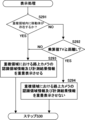
- FIG 8 is a flowchart showing an example of display control of the processing device 103.
- the display control unit 103D determines whether or not a moving object is present in the overlap area Z based on the measurement result information acquired in the previous step S27 and information indicating the overlap area Z identified by the surrounding environment recognition processing unit 103C (step S291). Specifically, the display control unit 103D determines whether or not a moving object recognized in the recognition area E of the road camera 100 by the surrounding environment recognition processing (step S13) of the road camera 100 in communication with the vehicle 10 is present in the identified overlap area Z.
- the display control unit 103D determines that a moving object is present within the overlap area Z (YES in step S291), it executes a process of superimposing and displaying on the display device 18 the recognition area information acquired from the road camera 100 that is in communication with the vehicle 10, together with the moving object information of the moving object present within the overlap area Z (step S293).
- FIG. 9 is an explanatory diagram showing an example of a superimposed display when it is determined that a moving object is present in the overlap area Z in the situation shown in FIG. 7.
- information indicating the range of the overlap area Z recognized by the road camera 100 as the recognition area information, and the outline of the moving object O recognized by the road camera 100 as the moving object information are superimposed on the real space around the vehicle 10 and AR displayed on the front window 181.
- the displayed recognition area information includes at least information on the outermost edge of the detection range with the road camera 100 as the base point.
- the "outermost edge of the detection range" is the boundary that is furthest from the road camera 100 (base point) among the boundaries that define the overlap area Z, and corresponds to the detection limit position that is furthest from the road camera 100.
- the detection range when the road camera 100 recognized the moving object O is explicitly presented to the driver of the vehicle 10.
- This allows the driver of the vehicle 10 to clearly understand to what extent of the blind spot area D the road camera 100 detected before recognizing the moving object O.
- This promotes the driver of the vehicle 10 to be aware of the danger of the moving object O, which is likely to enter ahead of the vehicle 10 in the traveling direction. Therefore, for example, even if the moving object O suddenly appears ahead of the vehicle 10 in the traveling direction, the driver will be more likely to take action to avoid the moving object O.
- FIG. 9 shows an example in which the road camera 100 recognizes an area of the blind spot area D that includes a road R2 where a moving object such as a pedestrian may be present, and displays the outer edge of the recognized area (the outer edge of the detection range of the road camera 100) in AR. This allows the driver of the vehicle 10 to clearly understand the extent to which the road camera 100 has detected a moving object O within the blind spot area D when the road camera 100 recognizes the moving object O.
- the display control unit 103D determines that no moving object is present in the overlap region Z (NO in S291), it compares a predetermined multiplication value TV with the distance L and determines whether the multiplication value TV is equal to or greater than the distance L (step S292).
- the multiplication value TV is a value obtained by multiplying the time T required for the vehicle 10 to reach the intersection X by a predetermined moving speed V, and indicates the estimated distance traveled by a moving object assumed to be present on the road R2 by the time t2 when the vehicle 10 reaches the intersection X.
- the distance L indicates the distance between the outermost edge of the overlap region Z (the portion indicated by the thick solid line in FIG. 7) and the intersection X, with the road camera 100 as the base point.
- step S292 the display control unit 103D calculates whether or not a moving object is expected to travel a distance L or more on road R2 by time t2 when the vehicle 10 reaches the intersection X.
- intersection X is used as information indicating, for example, the position where the center line of the lane on road R1 on which vehicle 10 is traveling intersects with the center line of road R2 (point P in FIG. 7).
- the position of intersection X when used in calculation processing may be determined based on any criteria.
- the processing device 103 calculates the time T required for the vehicle 10 to reach the intersection X from the current position based on, for example, a distance L1 from the current position of the vehicle 10 to the intersection X (point P) and the current vehicle speed of the vehicle 10.
- the distance L1 can be calculated from the detection result of the sensor device 12.
- the processing device 103 calculates the distance L1 between the coordinate position of the intersection X (point P) recorded in the map data and the current position of the vehicle 10.
- the current vehicle speed of the vehicle 10 may be calculated from the rate of change of the position information of the vehicle 10 detected by the vehicle position detection sensor 12D, or information on the vehicle speed detected by a vehicle speed sensor may be used. Note that the above-mentioned "current position" refers to the coordinate position of the vehicle 10 at the current time t1 .
- the predetermined moving speed V is the speed of a moving object assumed to be on road R2, and is set arbitrarily depending on the type of moving object, the speed limit of road R2, the road width or road type (such as a road in a residential area, a road in a shopping district, or a two-lane road with one lane in each direction), etc.
- the predetermined moving speed V is set to the speed limit of road R2.
- Information on the speed limit may be recorded in map data, for example, or may be obtained from an external information system.
- the moving speed V may be appropriately adjusted based on the speed limit depending on the road width or road type.
- the predetermined moving speed V may be set to an arbitrary value, such as 2.8 m/s (10 km/h).
- the distance L can be calculated as the distance between the coordinate position of the outermost edge of the overlap area Z (shown by the thick solid line in Figure 7) on the road R2 with the road camera 100 as the base point, which is identified from the recognition area information obtained from the road camera 100, and the coordinate position of the intersection X (black dot P).
- the display control unit 103D determines that at the arrival time t2 when the vehicle 10 arrives at the intersection X, a moving body that is not recognized on the road R2 at the current time t1 may enter the intersection X from outside the overlap area Z, and sets at least the recognition area information and measurement result information for the overlap area Z not to be displayed (step S294).
- the display control unit 103D determines that there is a possibility that a vehicle on road R2 will enter intersection X from outside the overlapping area Z at arrival time t2 , and sets the display device 18 not to display the recognition area information and the measurement result information.
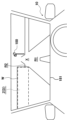
- FIG. 10 is an explanatory diagram showing an example of a display (non-display) on the front window 181 when it is determined that no moving object is present in the overlap area Z.
- the recognition area information is not AR-displayed on the front window 181.
- at least the measurement result information for the overlap area Z is not displayed. This requires the driver of the vehicle 10 to drive mainly according to his or her own judgment, and thus eliminates overconfidence in the function that notifies the driver of the blind spot situation. This reduces the risk of a collision between the vehicle and a moving object caused by the driver's overconfidence in this function.
- the display control unit 103D determines that there is a low possibility that a moving object on road R2 will enter intersection X from outside the overlap area Z at the arrival time t2 , and executes a process of driving the display device 18 to superimpose the recognition area information and the measurement result information on the front window (step S293).
- the maximum moving distance of the moving object on the road R2 from entering from outside the overlapping area Z is assumed to be 83 m ( ⁇ L: 100 m), and it is assumed that there is a low possibility that a moving object will arrive at the intersection X from outside the overlapping area Z at the arrival time t2 when the vehicle 10 arrives at the intersection X.
- the display control unit 103D executes a process of superimposing and displaying the recognition area information and the measurement result information by the display device 18.
- the display control unit 103D executes a process of superimposing and displaying the recognition area information and the measurement result information by the display device 18.
- the road camera 100 does not recognize the moving object in the overlapping area Z
- the moving object information about the moving object in the overlapping area Z is not displayed.
- FIG. 11 is an explanatory diagram showing an example of a display (superimposed display) on the front window 181 when it is determined that no moving object is present within the overlap area Z.
- the outer edge of the detection range of the road camera 100 in the overlap area Z is AR-displayed on the front window 181 as the recognition area information.
- moving object information about the moving object within the overlap area Z is not displayed.
- the detection range of the road camera 100 is explicitly presented to the driver of the vehicle 10, so that the driver of the vehicle 10 can clearly understand that no moving object is present within the detection range.
- the driver of the vehicle 10 can pass through the intersection X with confidence in the driving assistance function, and the psychological burden on the driver is reduced.
- the processing device 103 determines whether or not a moving object on the road R2 may enter the intersection X from outside the overlap area Z at the time t2 when the vehicle 10 reaches the intersection X, based on the multiplication value TV obtained by multiplying the time T required for the vehicle 10 to reach the intersection X by a predetermined moving speed, and the distance L between the outermost edge of the overlap area Z with the road camera 100 as the base point and the intersection X.
- the processing device 103 can determine whether or not a moving object that may reach the intersection X can be assumed at the time t2 when the vehicle 10 reaches the intersection X, taking into account the moving speed of the moving object assumed to be present on the road R2. This can increase the accuracy of determining whether or not a moving object that may be dangerous to the vehicle 10 can be assumed.
- the display control unit 103D when the display control unit 103D superimposes and displays the recognition area information, it displays the outer edge of the detection range of the overlap area Z on road R2 where a moving object may be present in AR, but the displayed recognition area information is not limited to the above example.
- the display control unit 103D may display the entire overlap area Z together with the outer edge of the detection range of the road camera 100, or may display the outer edge of the entire detection range of the road camera 100 (recognition area E) instead of just the overlap area Z. Even when the recognition area information is displayed in this manner, the same effect as in the above embodiment can be obtained.
- the vehicle 10 and the road camera 100 are connected via road-to-vehicle communication N1, but this is not limiting, and the vehicle 10 and the road camera 100 may be connected to an information processing device such as a cloud server so that they can communicate with each other.
- the control device 110 of the road camera 100 may transmit the recognition area information and the measurement result information to the information processing device.
- the control device 110 may transmit the recognition area information and the measurement result information to the information processing device after receiving a transmission request from the information processing device.
- the information processing device has a database that records the recognition area information for each of the multiple road cameras 100
- the road camera 100 may transmit only identification information for identifying each road camera 100 to the information processing device.
- the surrounding environment recognition process (step S13) is executed by the control device 110 of the road camera 100, but this is not limited to the above, and may be executed by the driving assistance device 11 of the vehicle 10 or an information processing device such as a cloud server.
- the surrounding environment recognition process (step S23) is executed by the processing device 103 of the vehicle 10, but this is not limited to the above, and may be executed by the control device 110 of the road camera 100, or an information processing device such as a cloud server.
- the overlap area Z is an area where the recognition area E of the road camera 100 overlaps with the blind spot area D, but is not limited to this and may be, for example, an area where the detection range of a sensor device mounted on the other vehicle 20 overlaps with the blind spot area D.
- the above driving assistance processing method may be executed using a sensor device mounted on the other vehicle 20 as the surrounding environment recognition device.
- the detection range is an example of a "recognition area.”
- the moving speed information of the vehicle 10 is generated based on the position information detected by the vehicle position detection sensor 12D, but this is not limited to this.
- the moving speed information of the vehicle 10 may be generated based on sensor information from a wheel speed sensor or a vehicle speed sensor.
- step S23 feature points are extracted from the image information generated by the front imaging cameras 12A, 12B and the rear imaging camera 12C, and the blind spot area D is detected based on these feature points, but this is not limited to the above.
- point cloud data extracted by LiDAR for objects present around the vehicle 10 may be used to detect the blind spot area D.
- the recognition area information and moving object information are displayed superimposed on the real space (AR display), but this is not limited thereto, and they may be displayed superimposed on the map data, or may be displayed superimposed on the captured image of the real space.
- map data includes, for example, information on the coordinate positions of objects, lane information, building information, and other display information.
- the driving assistance device and the driving assistance method exemplified in the above embodiment are applied to a passenger vehicle, the driving assistance device and the driving assistance method of the present disclosure may be applied to a moving body other than a passenger vehicle, and the application of the present disclosure is not particularly limited.
- the technology of the present disclosure is not limited to the above-mentioned embodiments. It is clear that a person having ordinary knowledge in the technical field to which the present disclosure belongs can come up with various modified or amended examples within the scope of the technical ideas described in the claims, and it is understood that these also naturally belong to the technical scope of the present disclosure.
- some of the functions of the driving assistance device and the road camera exemplified in the above embodiment may be provided in another device.
- the driving assistance device is an electronic control device mounted on a vehicle, but the technology of the present disclosure is not limited to this example.
- the driving assistance device may be a mobile terminal that is configured to be able to communicate with a device other than the vehicle and issues a drive command to an arbitrary display device.
- a mobile terminal examples include a laptop computer, a mobile phone, a smartphone, and a tablet terminal.
- the "coordinate position" in the above embodiment refers to a two-dimensional coordinate position of an object indicated by latitude and longitude, but is not limited to this, and may be, for example, a three-dimensional coordinate position in real space indicated by latitude, longitude, and altitude.
- the technology disclosed herein can also be realized as a vehicle equipped with the driving assistance device described in the above embodiments, a driving assistance method using the driving assistance device, a computer program that causes a computer to function as the above driving assistance device, and a non-transitory tangible recording medium on which the computer program is recorded.
- a driving assistance device is a driving assistance device that assists in driving a vehicle, and includes one or more processors and one or more memories communicably connected to the one or more processors.
- the one or more processors execute a process of acquiring at least recognition area information and measurement result information from at least one environment recognition device outside the vehicle, and a process of superimposing and displaying the recognition area information and information on the moving object on map data, real space, or a captured image of real space when a moving object is detected by the environment recognition device in an overlapping area between a blind spot area that is a blind spot from the vehicle and the recognition area of the environment recognition device.
- the driver of the vehicle when a moving object is recognized by a road camera in a blind spot area, the driver of the vehicle can clearly grasp the extent to which the road camera has detected the moving object. This promotes the driver of the vehicle's sense of danger regarding the moving object. Therefore, for example, even if the moving object jumps out in front of the vehicle in the traveling direction, the driver can easily take action to avoid the moving object.
- the one or more processors execute a process of determining whether or not a moving object on the second moving path may enter the junction from outside the overlapping area at the time when the vehicle reaches a junction between a first moving path on which the vehicle is traveling and a second moving path that merges with the first moving path, and a process of not displaying the recognition area information on the map data, the real space, or the captured image of the real space when it is determined that a moving object on the second moving path may enter.
- the driver of the vehicle is required to drive mainly according to his/her own judgment, and does not over-trust the function that notifies the driver of the situation in the blind spot. Therefore, the risk of a collision between the vehicle and the moving object caused by the driver's over-trust in the function is suppressed.
- the one or more processors execute a process of determining whether or not a moving object on the second path of movement may enter the junction from outside the overlapping area at the time the vehicle arrives at the junction, and a process of displaying the recognition area information superimposed on map data, real space, or a captured image of real space when it is determined that the moving object on the second path of movement will not enter the junction.
- the detection range of the road camera is explicitly presented to the driver of the vehicle, so that the driver of the vehicle can clearly understand that there is no moving object within the detection range. Therefore, the driver of the vehicle can pass the junction with confidence in the driving assistance function, and the psychological burden on the driver is reduced.
- the one or more processors determine whether or not a moving object on the second path of travel may enter the junction from outside the overlapping area at the time the vehicle reaches the junction, based on a multiplied value obtained by multiplying a predetermined moving speed by the time required for the vehicle to reach the junction and the distance between the junction and the outermost edge of the overlapping area starting from the environment recognition device.
- the driving assistance device can determine whether or not a moving object that may reach the junction can be assumed at the time the vehicle reaches the junction, taking into account the moving speed of a moving object assumed to be on the second path of travel. This can increase the accuracy of determining whether or not a moving object that may be dangerous to the vehicle can be assumed.
- a driving assistance method includes the steps of: one or more processors acquiring at least recognition area information and measurement result information from at least one environment recognition device outside the vehicle; and, when a moving object is detected by the environment recognition device in an overlapping area between a blind spot area that is a blind spot from the vehicle's perspective and the recognition area of the environment recognition device, displaying the recognition area information and information about the moving object superimposed on map data, real space, or a captured image of the real space.
- the driver of the vehicle can clearly grasp the extent to which the road camera has detected the moving object. This promotes the driver's awareness of danger regarding the moving object. Therefore, for example, even if the moving object jumps out ahead in the direction of travel of the vehicle, it becomes easier to take action to avoid the moving object.
- a non-transitory tangible recording medium stores a computer program that causes a processor to execute a process including acquiring at least recognition area information and measurement result information from at least one environment recognition device outside the vehicle, and, when a moving object is detected by the environment recognition device in an overlapping area between a blind spot area that is a blind spot from the vehicle's perspective and the recognition area of the environment recognition device, displaying the recognition area information and information about the moving object superimposed on map data, real space, or a captured image of the real space.
- the processor allows the driver of the vehicle to clearly grasp the extent to which a road camera has detected a moving object in a blind spot area. This promotes the driver's awareness of the danger of the moving object. Therefore, for example, even if a moving object jumps out ahead of the vehicle in the traveling direction, the driver is more likely to take action to avoid the moving object.
- a computer program causes a processor to execute a process including acquiring at least recognition area information and measurement result information from at least one environment recognition device outside the vehicle, and, when a moving object is detected by the environment recognition device in an overlapping area between a blind spot area that is a blind spot from the vehicle's perspective and the recognition area of the environment recognition device, displaying the recognition area information and information about the moving object superimposed on map data, real space, or a captured image of the real space.
- the processor allows the driver of the vehicle to clearly grasp the extent to which a road camera has detected a moving object in a blind spot area. This promotes the driver's awareness of the danger of the moving object. Therefore, for example, even if a moving object jumps out ahead of the vehicle in the traveling direction, the driver is more likely to take action to avoid the moving object.
- Driving assistance system 10 ... Assisted vehicle 11... Driving assistance device 20... Other vehicle 100... Road camera (environment recognition device) D...Blind spot area E...Recognition area R1...Road (first travel route) R2...Road (second travel route) X: intersection (junction) Z: overlapping area
Landscapes
- Engineering & Computer Science (AREA)
- Physics & Mathematics (AREA)
- General Physics & Mathematics (AREA)
- Remote Sensing (AREA)
- Radar, Positioning & Navigation (AREA)
- Automation & Control Theory (AREA)
- Multimedia (AREA)
- Theoretical Computer Science (AREA)
- Mechanical Engineering (AREA)
- Transportation (AREA)
- Human Computer Interaction (AREA)
- Mathematical Physics (AREA)
- Traffic Control Systems (AREA)
Abstract
Priority Applications (3)
| Application Number | Priority Date | Filing Date | Title |
|---|---|---|---|
| JP2025508032A JPWO2024195065A1 (fr) | 2023-03-22 | 2023-03-22 | |
| PCT/JP2023/011319 WO2024195065A1 (fr) | 2023-03-22 | 2023-03-22 | Dispositif d'aide à la conduite, procédé d'aide à la conduite et support d'enregistrement |
| US18/969,376 US12603007B2 (en) | 2023-03-22 | 2024-12-05 | Driver assistance apparatus, driver assistance method, and non-transitory recording medium |
Applications Claiming Priority (1)
| Application Number | Priority Date | Filing Date | Title |
|---|---|---|---|
| PCT/JP2023/011319 WO2024195065A1 (fr) | 2023-03-22 | 2023-03-22 | Dispositif d'aide à la conduite, procédé d'aide à la conduite et support d'enregistrement |
Related Child Applications (1)
| Application Number | Title | Priority Date | Filing Date |
|---|---|---|---|
| US18/969,376 Continuation US12603007B2 (en) | 2023-03-22 | 2024-12-05 | Driver assistance apparatus, driver assistance method, and non-transitory recording medium |
Publications (1)
| Publication Number | Publication Date |
|---|---|
| WO2024195065A1 true WO2024195065A1 (fr) | 2024-09-26 |
Family
ID=92841471
Family Applications (1)
| Application Number | Title | Priority Date | Filing Date |
|---|---|---|---|
| PCT/JP2023/011319 Ceased WO2024195065A1 (fr) | 2023-03-22 | 2023-03-22 | Dispositif d'aide à la conduite, procédé d'aide à la conduite et support d'enregistrement |
Country Status (3)
| Country | Link |
|---|---|
| US (1) | US12603007B2 (fr) |
| JP (1) | JPWO2024195065A1 (fr) |
| WO (1) | WO2024195065A1 (fr) |
Citations (2)
| Publication number | Priority date | Publication date | Assignee | Title |
|---|---|---|---|---|
| JP2001101566A (ja) * | 1999-09-30 | 2001-04-13 | Toshiba Corp | 交通安全確認システム |
| US20210067926A1 (en) * | 2018-01-15 | 2021-03-04 | Lg Electronics Inc. | Apparatus and method for v2x communication |
Family Cites Families (18)
| Publication number | Priority date | Publication date | Assignee | Title |
|---|---|---|---|---|
| JP4103518B2 (ja) | 2002-09-20 | 2008-06-18 | 株式会社エクォス・リサーチ | 車載画像表示装置 |
| JP4311420B2 (ja) | 2006-08-11 | 2009-08-12 | 住友電気工業株式会社 | 接近移動体表示装置、システム及び方法 |
| JP5053776B2 (ja) * | 2007-09-14 | 2012-10-17 | 株式会社デンソー | 車両用視界支援システム、車載装置、及び、情報配信装置 |
| JP2008217813A (ja) * | 2008-04-08 | 2008-09-18 | Sumitomo Electric Ind Ltd | 衝突情報提供装置及び方法 |
| US9934689B2 (en) * | 2014-12-17 | 2018-04-03 | Toyota Motor Engineering & Manufacturing North America, Inc. | Autonomous vehicle operation at blind intersections |
| WO2017209313A1 (fr) * | 2016-05-30 | 2017-12-07 | 엘지전자 주식회사 | Dispositif d'affichage de véhicule et véhicule |
| JP6807021B2 (ja) * | 2016-11-18 | 2021-01-06 | 株式会社オートネットワーク技術研究所 | 車両用物体検知装置及び車両用物体検知システム |
| JP6916609B2 (ja) * | 2016-11-21 | 2021-08-11 | パナソニック インテレクチュアル プロパティ コーポレーション オブ アメリカPanasonic Intellectual Property Corporation of America | 交差点情報配信装置及び交差点情報配信方法 |
| EP3548845B1 (fr) * | 2017-01-12 | 2021-10-13 | Mobileye Vision Technologies Ltd. | Navigation basée sur une activité de véhicule |
| US10453344B2 (en) * | 2017-02-16 | 2019-10-22 | Panasonic Intellectual Corporation Of America | Information processing apparatus and non-transitory recording medium |
| US11787287B2 (en) * | 2017-11-17 | 2023-10-17 | Aisin Corporation | Vehicle drive assist system, vehicle drive assist method, and vehicle drive assist program |
| JP2019202589A (ja) | 2018-05-22 | 2019-11-28 | 日本精機株式会社 | 表示装置 |
| JP6557843B1 (ja) * | 2018-12-05 | 2019-08-14 | パナソニックIpマネジメント株式会社 | 車両の制御装置、制御システム、及び制御プログラム |
| US11332132B2 (en) * | 2019-08-30 | 2022-05-17 | Argo AI, LLC | Method of handling occlusions at intersections in operation of autonomous vehicle |
| US11635763B2 (en) * | 2020-02-28 | 2023-04-25 | Nissan North America, Inc. | 3D occlusion reasoning for accident avoidance |
| WO2022097365A1 (fr) * | 2020-11-06 | 2022-05-12 | 日立Astemo株式会社 | Dispositif et procédé de reconnaissance d'un environnement extérieur |
| WO2024116364A1 (fr) * | 2022-12-01 | 2024-06-06 | 株式会社Subaru | Dispositif d'aide à la conduite, véhicule, support d'enregistrement sur lequel est enregistré un programme informatique et procédé d'aide à la conduite |
| JP7852527B2 (ja) * | 2023-01-25 | 2026-04-28 | トヨタ自動車株式会社 | 表示システム |
-
2023
- 2023-03-22 WO PCT/JP2023/011319 patent/WO2024195065A1/fr not_active Ceased
- 2023-03-22 JP JP2025508032A patent/JPWO2024195065A1/ja active Pending
-
2024
- 2024-12-05 US US18/969,376 patent/US12603007B2/en active Active
Patent Citations (2)
| Publication number | Priority date | Publication date | Assignee | Title |
|---|---|---|---|---|
| JP2001101566A (ja) * | 1999-09-30 | 2001-04-13 | Toshiba Corp | 交通安全確認システム |
| US20210067926A1 (en) * | 2018-01-15 | 2021-03-04 | Lg Electronics Inc. | Apparatus and method for v2x communication |
Also Published As
| Publication number | Publication date |
|---|---|
| US20250095495A1 (en) | 2025-03-20 |
| JPWO2024195065A1 (fr) | 2024-09-26 |
| US12603007B2 (en) | 2026-04-14 |
Similar Documents
| Publication | Publication Date | Title |
|---|---|---|
| CN109466542B (zh) | 车辆控制装置、车辆控制方法及存储介质 | |
| CN112537295B (zh) | 驾驶辅助装置 | |
| CN109515434B (zh) | 车辆控制装置、车辆控制方法及存储介质 | |
| CN109421799B (zh) | 车辆控制装置、车辆控制方法及存储介质 | |
| JP6402684B2 (ja) | 表示装置 | |
| JP2019182305A (ja) | 車両制御装置、車両制御方法、およびプログラム | |
| CN115443234A (zh) | 车辆行为推定方法、车辆控制方法及车辆行为推定装置 | |
| JP7852098B2 (ja) | 情報処理装置、および情報処理システム、並びにプログラム | |
| JP7606628B2 (ja) | 運転支援装置及び車両並びにコンピュータプログラムを記録した記録媒体 | |
| JP2022098397A (ja) | 情報処理装置、および情報処理方法、並びにプログラム | |
| US12142057B2 (en) | Information recording device, information recording method, and storage medium | |
| JP7619853B2 (ja) | 運転支援装置 | |
| US12485891B2 (en) | Driving assistance apparatus, vehicle, and non-transitory recording medium | |
| US12391239B2 (en) | Driving assistance device, driving assistance method, and storage medium | |
| JP7853131B2 (ja) | 運転支援システム及びコンピュータプログラム | |
| JP7521862B2 (ja) | 運転支援装置 | |
| US20230294679A1 (en) | Driving assistance device, driving assistance method, and storage medium | |
| US12509069B2 (en) | Driver assistance apparatus, vehicle, recording medium storing computer program, and driver assistance method | |
| WO2024195065A1 (fr) | Dispositif d'aide à la conduite, procédé d'aide à la conduite et support d'enregistrement | |
| JP7708985B2 (ja) | 運転支援装置、運転支援方法及び記録媒体 | |
| US12617283B2 (en) | Driving assistance apparatus, driving assistance method, and non-transitory recording medium | |
| JP7785175B2 (ja) | 運転支援装置、運転支援方法、およびプログラム | |
| JP7743938B2 (ja) | 運転支援方法及び運転支援装置 | |
| US20250218065A1 (en) | Information processing apparatus and information processing method | |
| JP7781134B2 (ja) | 車両制御装置、車両制御方法、およびプログラム |
Legal Events
| Date | Code | Title | Description |
|---|---|---|---|
| 121 | Ep: the epo has been informed by wipo that ep was designated in this application |
Ref document number: 23928645 Country of ref document: EP Kind code of ref document: A1 |
|
| ENP | Entry into the national phase |
Ref document number: 2025508032 Country of ref document: JP Kind code of ref document: A |
|
| WWE | Wipo information: entry into national phase |
Ref document number: 2025508032 Country of ref document: JP |
|
| NENP | Non-entry into the national phase |
Ref country code: DE |
|
| 122 | Ep: pct application non-entry in european phase |
Ref document number: 23928645 Country of ref document: EP Kind code of ref document: A1 |