CN103759727A - Navigation and positioning method based on sky polarized light distribution mode - Google Patents

Navigation and positioning method based on sky polarized light distribution mode Download PDF

Info

Publication number
CN103759727A
CN103759727A CN201410012966.7A CN201410012966A CN103759727A CN 103759727 A CN103759727 A CN 103759727A CN 201410012966 A CN201410012966 A CN 201410012966A CN 103759727 A CN103759727 A CN 103759727A
Authority
CN
China
Prior art keywords
polarized light
polarization
sky
information
distribution pattern
Prior art date
Legal status (The legal status is an assumption and is not a legal conclusion. Google has not performed a legal analysis and makes no representation as to the accuracy of the status listed.)
Granted
Application number
CN201410012966.7A
Other languages
Chinese (zh)
Other versions
CN103759727B (en
Inventor
崔岩
陈小龙
陈辰
李晨牧
褚金奎
关乐
张然
Current Assignee (The listed assignees may be inaccurate. Google has not performed a legal analysis and makes no representation or warranty as to the accuracy of the list.)
Dalian University of Technology
Original Assignee
Dalian University of Technology
Priority date (The priority date is an assumption and is not a legal conclusion. Google has not performed a legal analysis and makes no representation as to the accuracy of the date listed.)
Filing date
Publication date
Application filed by Dalian University of Technology filed Critical Dalian University of Technology
Priority to CN201410012966.7A priority Critical patent/CN103759727B/en
Publication of CN103759727A publication Critical patent/CN103759727A/en
Application granted granted Critical
Publication of CN103759727B publication Critical patent/CN103759727B/en
Expired - Fee Related legal-status Critical Current
Anticipated expiration legal-status Critical

Links

Images

Classifications

    • GPHYSICS
    • G01MEASURING; TESTING
    • G01CMEASURING DISTANCES, LEVELS OR BEARINGS; SURVEYING; NAVIGATION; GYROSCOPIC INSTRUMENTS; PHOTOGRAMMETRY OR VIDEOGRAMMETRY
    • G01C21/00Navigation; Navigational instruments not provided for in groups G01C1/00 - G01C19/00
    • G01C21/02Navigation; Navigational instruments not provided for in groups G01C1/00 - G01C19/00 by astronomical means
    • GPHYSICS
    • G01MEASURING; TESTING
    • G01CMEASURING DISTANCES, LEVELS OR BEARINGS; SURVEYING; NAVIGATION; GYROSCOPIC INSTRUMENTS; PHOTOGRAMMETRY OR VIDEOGRAMMETRY
    • G01C21/00Navigation; Navigational instruments not provided for in groups G01C1/00 - G01C19/00
    • G01C21/20Instruments for performing navigational calculations

Landscapes

  • Engineering & Computer Science (AREA)
  • Radar, Positioning & Navigation (AREA)
  • Remote Sensing (AREA)
  • Physics & Mathematics (AREA)
  • Automation & Control Theory (AREA)
  • General Physics & Mathematics (AREA)
  • Astronomy & Astrophysics (AREA)
  • Optical Communication System (AREA)
  • Position Fixing By Use Of Radio Waves (AREA)

Abstract

本发明一种基于天空偏振光分布模式的导航定位方法属于一种天文导航定位领域,涉及一种天空偏振光分布模式的导航定位方法。该方法完全利用天空偏振光进行自主导航和定位,通过太阳高度方位信息和测试地点位置信息,计算得到天空偏振光分布模式理论数据信息,然后将实时测试的偏振模式数据信息和理论数据信息进行数据匹配,匹配成功后直接可以根据天空偏振光分布模式的理论数据获得测试地点的准确位置信息。该方法完全利用天空偏振光进行自主导航和定位,无需借助其他辅助信息,实时性好,可操作性好,不受任何外界因素干扰,精度高,能够快速提供准确的航向信息和位置信息。

Figure 201410012966

The invention relates to a navigation and positioning method based on sky polarized light distribution mode, which belongs to the field of celestial navigation and positioning, and relates to a navigation and positioning method for sky polarized light distribution mode. This method completely uses sky polarized light for autonomous navigation and positioning, and calculates the theoretical data information of the sky polarized light distribution mode through the sun's altitude and orientation information and the location information of the test site, and then performs real-time test polarization mode data information and theoretical data information. Matching, after the matching is successful, the accurate location information of the test site can be directly obtained according to the theoretical data of the sky polarized light distribution mode. This method completely utilizes sky polarized light for autonomous navigation and positioning without the need for other auxiliary information. It has good real-time performance, good operability, is not disturbed by any external factors, has high precision, and can quickly provide accurate heading information and position information.

Figure 201410012966

Description

A kind of navigation locating method based on sky polarized light distribution pattern
Technical field
The invention belongs to a kind of celestial navigation localization method, relate in particular to a kind of navigation locating method of sky polarized light distribution pattern, belong to navigator fix field.
Background technology
Celestial navigation localization method based on sky polarized light distribution pattern is using sky polarized light distribution pattern as navigation beacon, by testing tool, obtain sky polarized light distribution pattern, obtain effective polarization navigation information, be a kind of autonomous navigate mode completely, thereby there is extremely strong antijamming capability.
Chinese scholars proposed respectively sky polarized light polarisation distribution pattern matching algorithm (beam Huawei. based on the navigation locating method of sky polarisation distribution pattern match: China, 201210504865.2[P] .2013-03-13) and utilize polarized light sensor perception self and sun meridian angle to determine course angle (Lambrinos D, Kobayashi H, Pfeifer R, et al.An autonomous agent navigating with a polarized light compass[J] .Adaptive behavior, 1997, 6 (1): 131-161.) the multiple navigation locating method such as.
The navigation locating method based on sky polarisation distribution pattern match that the scholars such as beam Huawei propose, by adopting polarization camera to obtain the local polarization information of sky polarized light in former and later two moment directly over polarization camera, through calculating the pseudo-chromaticity diagram of synthetic sky polarized light distribution pattern, then extract minutiae carries out modeling, set up former and later two moment sky polarized light distribution patterns and radiate accordingly transformation relation, realize location navigation.Because sky polarized light distribution pattern can be subject to the interference of meteorologic factor, and the method will be obtained the sky polarization information in former and later two moment, if the polarization information in a certain moment does not successfully obtain the local message that maybe cannot obtain sky polarized light, under non-fine day condition especially, in the time of cannot obtaining the local polarization information of sky polarized light, cannot realize navigator fix, and set up radiation and be related to complexity, positioning precision is low, has significant limitation.
The air navigation aid of utilizing polarized light sensor perception self and sun meridian angle of the propositions such as Lambrinos D, can only obtain course angle, cannot realize accurate location.Need to design corresponding sky polarotactic navigation sensor, be equipped with the navigator such as gyroscope and accelerometer and could realize location, and navigation and positioning accuracy is subject to the restriction of hardware device, precision is low, and cost is high, can poor practicability.
Summary of the invention
The object of the invention is to overcome existing sky polarized light polarization mode matching navigation method and be subject to the defect that meteorologic factor is disturbed and sensor-based air navigation aid cannot be located, invent a kind of method that can utilize sky polarized light distribution pattern to realize Navigation and localization for various weather conditions, the method utilizes sky polarized light to carry out independent navigation and location completely, without by other supplementarys, real-time is good, operability is good, not disturbed by any extraneous factor, precision is high, can supply course information and positional information accurately by Quick.
It is a kind of navigation locating method based on sky polarized light distribution pattern that the present invention adopts technical scheme, the method utilizes sky polarized light to carry out independent navigation and location completely, by altitude of the sun azimuth information and testing location positional information, calculate sky polarized light distribution pattern gross data information, then the polarization mode data message of real-time testing and gross data information are carried out to Data Matching, the accurate location information that directly can obtain according to the gross data of sky polarized light distribution pattern testing location after the match is successful, the concrete steps of the method are as follows:
(1) theoretical model of establishment sky polarized light distribution pattern, then sets up polarization azimuth and degree of polarization distribution pattern database according to different testing location positional information and local solar azimuth information.
(2) in mobile device traveling process, utilize the sky polarized light test instrument on it to carry out the test of all-sky polarized light distribution pattern, in test process, testing tool successively gathers the light intensity data of all-sky finite point, while testing certain any light intensity data, polaroid need to rotate 0 ゜, 60 ゜ and tri-polarization directions of 120 ゜, the light intensity data collecting is denoted as respectively 120 ° of 0 ° of I ', 60 ° of I ' and I ', according to Stokes vector: wherein I, Q, U is first three component of Stokes vector, and the 4th component circular component is zero, i.e. V=0:
Figure BDA0000455529820000031
According to formula (1), obtain three components of Stokes vector, as the formula (2):
Last according to the relation of Stokes vector and degree of polarization and polarization azimuth, obtain the degree of polarization P of day aerial a certain point ijwith polarization azimuth θ ij:
P ij = Q 2 + U 2 I θ ij = 1 2 a tan U Q - - - ( 3 )
By regulating instrument, successive test obtains the data message of all-sky polarized light distribution pattern.
A) if sunny weather directly carries out step (4);
B) if the sunny weather of right and wrong extracts the characteristic information of sky polarized light distribution pattern;
(3) utilize the characteristic information of extraction and theory and the rule of existing sky polarized light distribution pattern to carry out inverting and the reconstruct of all-sky polarized light distribution pattern; The most obvious characteristic information existing in sky polarized light distribution pattern is neutral point, the degree of polarization of neutral point is zero, and there is the variation of 90 ゜ in polarization azimuth, sky polarized light degree of polarization distributes in the form of a ring about neutral point and the sun, when solar angle distance is 90 ゜, degree of polarization reaches maximal value, and whole sky polarized light distribution pattern is about this maximum polarized line and the meridian symmetry of crossing the sun and zenith.Therefore at a time with a certain definite place, can carry out inverting and the reconstruct of distribution pattern according to the photodistributed regularity of distribution of sky polarization and symmetry characteristic, obtain the mode profile information that now sky polarized light is complete;
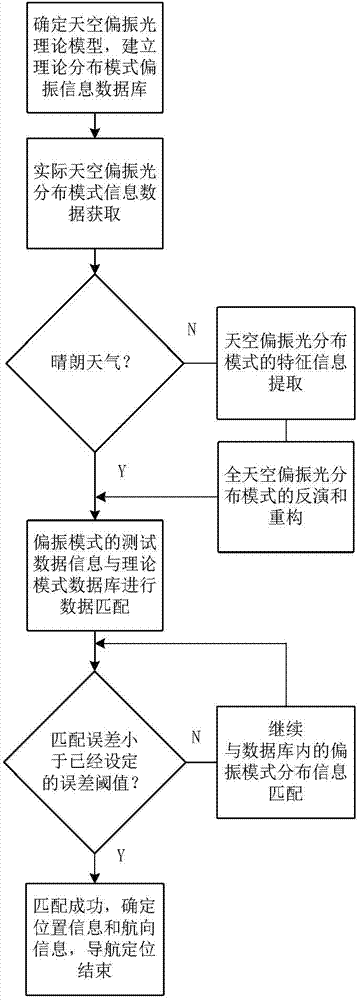
(4) utilize direct all-sky polarized light distribution pattern of testing or the polarization mode of inverting and reconstruct and the sky polarized light polarization azimuth of foundation and degree of polarization distribution pattern database to carry out Data Matching, if the Data Matching error of certain two sky polarized light distribution pattern is less than the error threshold of having set, think that Data Matching is successful; Otherwise continue coupling until the match is successful;
Concrete data matching method is that the data markers of the sky polarized light distribution pattern obtained by theoretical model is information aggregate ∑ χ 0, the polarization mode data markers of test is information aggregate ∑ χ, then adopts matching algorithm to information aggregate ∑ χ 0χ mates with information aggregate ∑, if the matching error of the two is less than threshold value Δ ∑ χ, thinks that Data Matching is successful, otherwise continues coupling, until the match is successful.
Figure BDA0000455529820000041
Figure BDA0000455529820000051
Σx = P θ - - - ( 6 )
Figure BDA0000455529820000053
Figure BDA0000455529820000054
Σ x 0 = P 0 θ 0 - - - ( 9 )
Δ∑χ=∑χ-∑χ 0 (10)
In formula (4), P represents the sky polarized light degree of polarization data message set of test, P ij(i=1,2 ... n; J=1,2 ... n) represent a day aerial a certain test point polarization degree information, in formula (5), θ represents the sky polarized light polarization azimuth data message set of test, θ ij(i=1,2 ... n; J=1,2 ... n) represent day aerial a certain test point polarization azimuth information, the degree of polarization data message of test and polarization azimuth data message be configuration information set ∑ χ after normalized, by formula (6), is represented; P in formula (7) 0the sky polarized light degree of polarization data message set that representation theory model calculates, P 0ij(i=1,2 ... n; J=1,2 ... n) represent a day aerial a certain theoretical model calculation level polarization degree information, θ in formula (8) 0the sky polarized light polarization azimuth data message set that representation theory model calculates, θ 0ij(i=1,2 ... n; J=1,2 ... n) represent day aerial a certain theoretical model calculation level polarization azimuth information, degree of polarization data message and polarization azimuth data message configuration information set ∑ χ after normalized that theoretical model calculates 0, by formula (9), being represented, match error threshold Δ ∑ χ, is represented by formula (10).
(5) when Data Matching is successful, test data is identical with the model data in database, because azimuth information, the solar azimuth information of the sky polarized light distribution pattern data in database and testing location have direct relevance, therefore, directly determine the now positional information of mobile device.
Described sky polarized light distribution pattern testing tool comprises polarization rotary system I, optical system II, spectrum receiving system III, computing machine IV, supporting construction V five parts, wherein, polarization rotary system I has been equipped with linear polarizer that can turn, spectrum receiving system III is used cosine corrector to be connected optical system and spectrometer with optical fiber, and the data that spectrometer collects send computing machine IV to; Described testing tool is arranged in supporting construction V; Described supporting construction V comprises equatorial telescope 1 and support platform 2, by regulating equatorial telescope to guarantee that instrument realizes the test of all-sky finite point; Sky polarized light light enters after optical system by polaroid, by spectrometer, gathers light intensity.
The invention has the beneficial effects as follows the navigation locating method based on sky polarized light distribution pattern, by altitude of the sun azimuth information and testing location positional information, calculate sky polarized light distribution pattern gross data information, then the polarization mode data message of real-time testing and gross data information are carried out to Data Matching, after the match is successful, directly can obtain according to the gross data of sky polarized light distribution pattern positional information and the position of sun information of testing location, not only can obtain course information, can also obtain positional information accurately, overcome existing sky polarotactic navigation equipment and can only determine course information or the shortcoming that need to position by other navigator, without utilizing satellite, the artificial electrical communication system such as radio base station, navigator fix process is simple, positioning precision is high, be not subject to interference from human factor, reliability is high, there is very high practicability.
Accompanying drawing explanation
Fig. 1 is sky polarized light distribution pattern database
Fig. 2 is sky polarized light theoretical distribution pattern modeling process flow diagram
Fig. 3 is sky polarized light test instrumentation diagram
Fig. 4 is sky polarized light distribution pattern positioning navigation method process flow diagram
Embodiment
Below in conjunction with accompanying drawing and technical scheme, describe specific embodiment of the invention in detail:
In the present invention, utilize sky polarized light test instrument to carry out the test of all-sky polarized light distribution pattern, this instrument comprises polarization rotary system I, optical system II, spectrum receiving system III, computing machine IV, supporting construction V five parts, sees Fig. 3.Wherein polarization rotary system I has been equipped with linear polarizer that can turn, and spectrum receiving system III is used cosine corrector to be connected optical system and spectrometer with optical fiber, and the data that spectrometer collects send computing machine IV to; Described testing tool is arranged in supporting construction V; Described supporting construction V comprises equatorial telescope 1 and support platform 2, and assurance instrument can be realized the test of all-sky finite point; Sky polarized light enters after optical system by polaroid, by spectrometer, gathers light intensity.
Embodiment, select to test under fine day condition, polarization mode on sun meridian is mated, be that testing tool is only tested sky polarized light distribution pattern data message on sun examination meridian and mated with the data message on the interior meridian of database, according to actual location precision, select threshold value Δ ∑ χ=0.25.
With reference to Fig. 2, Fig. 4: (1) establishes the theoretical model of sky polarized light distribution pattern, then according to different testing location positional information and local sun altitude azimuth informations, set up polarization azimuth and degree of polarization distribution pattern database; With reference to Fig. 1, by inputting 12: 12: 59 on the 12nd April of 2009 time in Christian era, geographic position is east longitude 121 ゜ 37 ' 12 "; north latitude 38 ゜ 55 ' 12 " time, sky polarized light distribution theory model database has been exported the distribution pattern of corresponding sky polarized light, as shown in the round shape figure in the lower left corner in figure, the direction indication polarization azimuth of its medium and small short-term deflection, the thickness of little short-term represents the size of degree of polarization.In the database of setting up, test point positional information, local altitude of the sun azimuth information and sky polarized light distribution pattern have direct correlation, if that is a certain moment test point positional information, local altitude of the sun azimuth information or temporal information are determined, there is unique sky polarized light distribution pattern corresponding with it, if known a certain sky polarized light distribution pattern, also has corresponding test point positional information and local altitude of the sun azimuth information corresponding with it.
(2) use sky polarized light test instrument to carry out the test of all-sky polarized light distribution pattern, obtain all-sky polarisation distribution mode data information, use described testing tool to test all-sky polarized light distribution pattern data message, in test process, testing tool successively gathers the light intensity data of all-sky finite point, in test process, polarization rotary system rotates respectively 0 ゜, 60 ゜ and tri-polarization directions of 120 ゜, collects the data message that obtains all-sky polarized light distribution pattern after light intensity data through computing; According to Stokes vector: wherein I, Q, U is first three component of Stokes vector, the 4th component circular component is zero, i.e. V=0:
Figure BDA0000455529820000081
According to formula (1), obtain three components of Stokes vector, as the formula (2):
Figure BDA0000455529820000091
Last according to the relation of Stokes vector and degree of polarization and polarization azimuth, obtain the degree of polarization P of day aerial a certain point ijwith polarization azimuth θ ij:
P ij = Q 2 + U 2 I θ ij = 1 2 a tan U Q - - - ( 3 )
By regulating instrument, successive test obtains the data message of all-sky polarized light distribution pattern.By corresponding data handling system, process, obtained the distribution pattern of corresponding sky polarized light, owing to being under fine day condition, therefore directly carry out distribution pattern Data Matching;
(3) extract the polarisation distribution mode data on sun meridian, and carry out Data Matching; Wherein, P and θ are respectively tests polarization degree and polarization azimuth data matrix on sun meridian, and ∑ χ is polarization information data acquisition on sun meridian; P ' 0and θ ' 0be respectively on the sun meridian extracting first group of degree of polarization and polarization azimuth data matrix from database, ∑ χ ' 0for polarization information data acquisition; P 0and θ 0be respectively second group of degree of polarization and polarization azimuth data matrix, ∑ χ 0for polarization information data acquisition (for convenience of description, selecting two groups of data to mate in database);
P=[2.221.86 1.82 2.34 2.86 16.81 33.10 70.17 83.8673.59
49.97 20.72 13.70]
θ=[100.88 69.96 26.94 109.64 105.76 100.68 99.55
95.65 94.69 98.49 96.54 100.17 98.37]
Σx = P θ = [ 2.22 1.86 1.82 2.34 2.86 16.81 33.10 70.17 83.8673 3.59 49.97 20.72 13.70 100.88 69.96 26.94 109.64 105.76 100.68 99.55
95.65 94.69 98.49 96.54 100.17 98.37
P′ 0=[3.30 3.614.6 33.9 60.7 88 100 86.9 59.3
32.8 143.3]
θ′ 0=[88.37 89.96 89.98 89.99 89.99 90 89.99 89.99 89.99
89.99 89.98 89.96]
Σ x 0 ′ = P 0 ′ θ 0 ′ = [ 3.3 0 3.6 14.6 33.9 60.7 88 100 86.9 59.3 32.8 14 3.3 88.37 89.96 89.98 89.99 89.99 90 89.99 89.99 89.99 89.99 89.98 89.96 ]
ΔΣx = Σx - Σ x 0 ′ = [ - 0.0108 0.0186 - 0.0178 - 0.1226 - 0.03104 - 0.4389 - 0.549 - 0.2983 - 0.0304 0.1429 0.1717 0.0672 0.104 0.1092 - 0.1841 - 0.6302 0.1966 0.1577 0.1069 0.0955 0.0566 0.047 0.085 0.0655 0.1019 0.0841 ]
First carry out ∑ χ and ∑ χ ' 0coupling, obtaining threshold value is Δ ∑ χ, the column criterion of going forward side by side processing, because surveyed data are the data on sun meridian, affected by the sun, polarization azimuth there will be larger saltus step, so reject trip point-0.6302 in threshold value after coupling, find the numerical value that has absolute value to be greater than 0.25 in Δ ∑ χ, therefore mate unsuccessfully, continue coupling.
P 0=[20.4 6.60.5 1.49.325.3 49.4 78 98.1 94.8 70.8
42.5 20.4]
θ 0=[89.62 89.38 87.74 88.66 89.47 89.65 90 90.23 90.22
90.22 90.24 90.28 90.38]
Σ x 0 = P 0 θ 0 = [ 20.4 6.6 0.5 1.4 9.3 25.3 49.4 78 98.1 94.8 70.8 42.5 20.4 89.62 89.38 87.74 88.66 89.47 89.65 90 90.23 90.22 90.22 90.24 90.28 90.38 ]
Δ∑χ=∑χ-∑χ0=[-0.18 -0.050.01 0.01 -0.06 -0.08
-0.16 -0.08-0.14-0.21-0.21-0.22-0.07
0.1126-0.1942-0.6080.20980.16290.11030.09550.0542
0.04470.08270.0630.09890.0799]
With ∑ χ 0coupling, obtaining threshold value is Δ ∑ χ, the column criterion of going forward side by side processing, because surveyed data are the data on sun meridian, affected by the sun, polarization azimuth there will be larger saltus step, so reject trip point-0.608 in threshold value after coupling, the absolute value of finding numerical value in Δ ∑ χ is all less than 0.25, therefore the match is successful, passes through Query Database, learn that geographical location information is now east longitude 121 ゜ 37 ' 12 " north latitude 38 ゜ 55 ' 12 ", time is 2007092114: 36 Beijing time, and so far location navigation success, illustrates that the present invention can implement.

Claims (2)

1. the navigation locating method based on sky polarized light distribution pattern, it comprises following technical step:
(1) theoretical model of establishment sky polarized light distribution pattern, then sets up polarization azimuth and degree of polarization distribution pattern database according to positional information and the local altitude of the sun azimuth information of different testing locations;
(2) in mobile device traveling process, utilize the sky polarized light test instrument on it to carry out the test of all-sky polarized light distribution pattern, in test process, testing tool successively gathers the light intensity data of all-sky finite point.While testing certain any light intensity data, polaroid need to rotate 0 ゜, 60 ゜ and tri-polarization directions of 120 ゜, the light intensity data collecting is denoted as respectively 120 ° of 0 ° of I ', 60 ° of I ' and I ', according to Stokes vector: wherein I, Q, U is first three component of Stokes vector, and the 4th component circular component is zero, i.e. V=0:
Figure FDA0000455529810000011
According to formula (1), obtain three components of Stokes vector, as the formula (2):
Figure FDA0000455529810000012
Last according to the relation of Stokes vector and degree of polarization and polarization azimuth, obtain the degree of polarization P of day aerial a certain point ijwith polarization azimuth θ ij:
P ij = Q 2 + U 2 I θ ij = 1 2 a tan U Q - - - ( 3 )
By regulating instrument, successive test obtains the data message of all-sky polarized light distribution pattern.
A) if sunny weather directly carries out step (4);
B) if the sunny weather of right and wrong extracts the characteristic information of sky polarized light distribution pattern;
(3) characteristic information that utilization is extracted and existing sky polarized light distribution pattern theory and rule are carried out inverting and the reconstruct of all-sky polarized light distribution pattern; The most obvious characteristic information existing in sky polarized light distribution pattern is neutral point, the degree of polarization of neutral point is zero, and the variation of 90 ゜ has occurred polarization azimuth, the position of neutral point changes in the scope apart from approximately 15 °~25 ° of sun point (or anti-sun point) angular distances; Sky polarized light degree of polarization distributes in the form of a ring about neutral point and the sun, and when solar angle distance is 90 ゜, degree of polarization reaches maximal value, and whole sky polarized light distribution pattern is about this maximum polarized line and the meridian symmetry of crossing the sun and zenith.Therefore at a time with a certain definite place, can carry out inverting and the reconstruct of distribution pattern according to the photodistributed regularity of distribution of sky polarization and symmetry characteristic, obtain the mode profile information that now sky polarized light is complete;
(4) utilize direct all-sky polarized light distribution pattern of testing or the polarization mode of inverting and reconstruct and the sky polarized light polarization azimuth of foundation and degree of polarization distribution pattern database to carry out Data Matching, if the Data Matching error of certain two sky polarized light distribution pattern is less than the error threshold of having set, think that Data Matching is successful; Otherwise continue coupling until the match is successful;
Concrete data matching method: the data markers of the sky polarized light distribution pattern of obtaining by theoretical model is information aggregate ∑ χ 0, the polarization mode data markers of test is information aggregate ∑ χ, then adopts matching algorithm to information aggregate ∑ χ 0χ mates with information aggregate ∑, if the matching error of the two is less than threshold value Δ ∑ χ, thinks that Data Matching is successful, otherwise continues coupling, until the match is successful.
Figure FDA0000455529810000031
Figure FDA0000455529810000032
Σx = P θ - - - ( 6 )
Figure FDA0000455529810000035
Σ x 0 = P 0 θ 0 - - - ( 9 )
Δ∑χ=∑χ-∑χ 0 (10)
In formula (4), P represents the sky polarized light degree of polarization data message set of test, P ij(i=1,2 ... n; J=1,2 ... n) represent a day aerial a certain test point polarization degree information, in formula (5), θ represents the sky polarized light polarization azimuth data message set of test, θ ij(i=1,2 ... n; J=1,2 ... n) represent day aerial a certain test point polarization azimuth information, tests polarization degrees of data information and polarization azimuth data message be configuration information set ∑ χ after normalized, by formula (6), is represented; P in formula (7) 0the sky polarized light degree of polarization data message set that representation theory model calculates, P 0ij(i=1,2 ... n; J=1,2 ... n) represent a day aerial a certain theoretical model calculation level polarization degree information, θ in formula (8) 0the sky polarized light polarization azimuth data message set that representation theory model calculates, θ 0ij(i=1,2 ... n; J=1,2 ... n) represent day aerial a certain theoretical model calculation level polarization azimuth information, theoretical model calculates degree of polarization data message and polarization azimuth data message configuration information set ∑ χ after normalized 0, by formula (9), being represented, match error threshold Δ ∑ χ, is represented by formula (10);
(5) when Data Matching is successful, test data is identical with the model data in database, because azimuth information, the solar azimuth information of the sky polarized light distribution pattern data in database and testing location have direct relevance, therefore, can directly determine the now positional information of mobile device.
2. the navigation locating method based on sky polarized light distribution pattern according to claim 1, it is characterized in that: the sky polarized light distribution pattern testing tool that the method adopts comprises polarization rotary system I, optical system II, spectrum receiving system III, computing machine IV, supporting construction V five parts, wherein, polarization rotary system I has been equipped with linear polarizer that can turn, spectrum receiving system III is used cosine corrector to be connected optical system and spectrometer with optical fiber, and the data that spectrometer collects send computing machine IV to; Described testing tool is arranged in supporting construction V; Described supporting construction V comprises equatorial telescope 1 and support platform 2, by regulating equatorial telescope to guarantee that instrument realizes the test of all-sky finite point; Sky polarized light enters after optical system by polaroid, by spectrometer, gathers light intensity.
CN201410012966.7A 2014-01-10 2014-01-10 Navigation and positioning method based on sky polarized light distribution mode Expired - Fee Related CN103759727B (en)

Priority Applications (1)

Application Number Priority Date Filing Date Title
CN201410012966.7A CN103759727B (en) 2014-01-10 2014-01-10 Navigation and positioning method based on sky polarized light distribution mode

Applications Claiming Priority (1)

Application Number Priority Date Filing Date Title
CN201410012966.7A CN103759727B (en) 2014-01-10 2014-01-10 Navigation and positioning method based on sky polarized light distribution mode

Publications (2)

Publication Number Publication Date
CN103759727A true CN103759727A (en) 2014-04-30
CN103759727B CN103759727B (en) 2017-05-24

Family

ID=50527003

Family Applications (1)

Application Number Title Priority Date Filing Date
CN201410012966.7A Expired - Fee Related CN103759727B (en) 2014-01-10 2014-01-10 Navigation and positioning method based on sky polarized light distribution mode

Country Status (1)

Country Link
CN (1) CN103759727B (en)

Cited By (12)

* Cited by examiner, † Cited by third party
Publication number Priority date Publication date Assignee Title
CN104034330A (en) * 2014-06-10 2014-09-10 西安电子科技大学 Indoor navigation system and method based on polarized light
CN106643703A (en) * 2017-01-10 2017-05-10 曲阜师范大学 A Polarized Light Navigation Algorithm Based on Dielectric Film Polarizing Right Angle Beamsplitter Prism
CN107063170A (en) * 2017-03-31 2017-08-18 中国人民解放军国防科学技术大学 Course angle estimation method based on atmospheric polarization angle mould formula under complex environment
CN107147833A (en) * 2017-06-08 2017-09-08 大连交通大学 A haze-degraded image full-polarization clearing device
CN108917749A (en) * 2018-07-11 2018-11-30 大连理工大学 One kind extracting the meridianal method of the sun based on polarization imaging
CN109668567A (en) * 2019-01-02 2019-04-23 中国人民解放军国防科技大学 A method of polarized light orientation for UAV under cloudy conditions
CN110231025A (en) * 2019-07-04 2019-09-13 中国人民解放军国防科技大学 Dynamic orientation method and system based on strapdown polarized light compass
CN110887476A (en) * 2019-12-09 2020-03-17 北京航空航天大学 Autonomous heading and attitude determination method based on polarization-astronomical angle information observation
CN112379399A (en) * 2020-10-27 2021-02-19 衡阳市智谷科技发展有限公司 Polarized light navigation positioning method based on multi-configuration fisheye camera
US11371846B2 (en) 2019-01-14 2022-06-28 Qatar Foundation For Education Science And Community Development Systems and methods for determining the position of a device
CN115683091A (en) * 2023-01-05 2023-02-03 北京航空航天大学 An autonomous positioning method based on time-sharing inversion and reconstruction of solar polarization neutral plane
CN119642826A (en) * 2024-12-23 2025-03-18 北京航空航天大学 Carrier three-dimensional attitude determination method based on double vector features of night polarized light field

Citations (2)

* Cited by examiner, † Cited by third party
Publication number Priority date Publication date Assignee Title
CN101008566A (en) * 2007-01-18 2007-08-01 上海交通大学 Intelligent vehicle vision device and its global positioning method based on ground texture
CN101281060A (en) * 2008-04-30 2008-10-08 大连理工大学 A Radiation Spectrum Measuring System of Sky Polarized Light

Patent Citations (2)

* Cited by examiner, † Cited by third party
Publication number Priority date Publication date Assignee Title
CN101008566A (en) * 2007-01-18 2007-08-01 上海交通大学 Intelligent vehicle vision device and its global positioning method based on ground texture
CN101281060A (en) * 2008-04-30 2008-10-08 大连理工大学 A Radiation Spectrum Measuring System of Sky Polarized Light

Non-Patent Citations (5)

* Cited by examiner, † Cited by third party
Title
YAN CUI等: "Patterns of Skylight Polarization at Different Atmospheric Conditions", 《KEY ENGINEERING MATERIALS》 *
关桂霞等: "单次散射条件下大气偏振中性点的特性研究", 《哈尔滨工程大学学报》 *
崔岩等: "太阳光与月光对曙暮光偏振模式的影响", 《光学精密工程》 *
褚金奎等: "气溶胶对天空偏振辐射影响的测量", 《光学精密工程》 *
赵开春等: "Rayleigh大气天空光偏振分布仿真与预测", 《四川大学学报(工程科学版)》 *

Cited By (22)

* Cited by examiner, † Cited by third party
Publication number Priority date Publication date Assignee Title
CN104034330B (en) * 2014-06-10 2017-03-22 西安电子科技大学 Indoor navigation system and method based on polarized light
CN104034330A (en) * 2014-06-10 2014-09-10 西安电子科技大学 Indoor navigation system and method based on polarized light
CN106643703B (en) * 2017-01-10 2020-01-31 曲阜师范大学 A Polarized Light Navigation Method Based on Dielectric Film Polarized Right Angle Beamsplitter Prism
CN106643703A (en) * 2017-01-10 2017-05-10 曲阜师范大学 A Polarized Light Navigation Algorithm Based on Dielectric Film Polarizing Right Angle Beamsplitter Prism
CN107063170A (en) * 2017-03-31 2017-08-18 中国人民解放军国防科学技术大学 Course angle estimation method based on atmospheric polarization angle mould formula under complex environment
CN107147833A (en) * 2017-06-08 2017-09-08 大连交通大学 A haze-degraded image full-polarization clearing device
CN107147833B (en) * 2017-06-08 2019-12-27 大连交通大学 Haze degraded image full-polarization clearing device
CN108917749A (en) * 2018-07-11 2018-11-30 大连理工大学 One kind extracting the meridianal method of the sun based on polarization imaging
CN108917749B (en) * 2018-07-11 2021-05-11 大连理工大学 Method for extracting solar meridian based on polarization imaging
CN109668567B (en) * 2019-01-02 2021-09-24 中国人民解放军国防科技大学 Polarized light orientation method, system and polarized light sensor for drones under cloudy conditions
CN109668567A (en) * 2019-01-02 2019-04-23 中国人民解放军国防科技大学 A method of polarized light orientation for UAV under cloudy conditions
US11371846B2 (en) 2019-01-14 2022-06-28 Qatar Foundation For Education Science And Community Development Systems and methods for determining the position of a device
CN110231025B (en) * 2019-07-04 2021-04-09 中国人民解放军国防科技大学 A dynamic orientation method and system based on strapdown polarized light compass
CN110231025A (en) * 2019-07-04 2019-09-13 中国人民解放军国防科技大学 Dynamic orientation method and system based on strapdown polarized light compass
CN110887476A (en) * 2019-12-09 2020-03-17 北京航空航天大学 Autonomous heading and attitude determination method based on polarization-astronomical angle information observation
CN110887476B (en) * 2019-12-09 2021-08-13 北京航空航天大学 Autonomous heading and attitude determination method based on polarization-astronomical angle information observation
CN112379399A (en) * 2020-10-27 2021-02-19 衡阳市智谷科技发展有限公司 Polarized light navigation positioning method based on multi-configuration fisheye camera
CN112379399B (en) * 2020-10-27 2023-12-26 衡阳市智谷科技发展有限公司 A polarized light navigation and positioning method based on multi-configuration fisheye cameras
CN115683091A (en) * 2023-01-05 2023-02-03 北京航空航天大学 An autonomous positioning method based on time-sharing inversion and reconstruction of solar polarization neutral plane
CN115683091B (en) * 2023-01-05 2023-04-04 北京航空航天大学 An autonomous positioning method based on time-sharing inversion and reconstruction of solar polarization neutral plane
CN119642826A (en) * 2024-12-23 2025-03-18 北京航空航天大学 Carrier three-dimensional attitude determination method based on double vector features of night polarized light field
CN119642826B (en) * 2024-12-23 2025-09-30 北京航空航天大学 A three-dimensional attitude determination method for a vehicle based on dual-vector characteristics of polarized light fields at night

Also Published As

Publication number Publication date
CN103759727B (en) 2017-05-24

Similar Documents

Publication Publication Date Title
CN103759727A (en) Navigation and positioning method based on sky polarized light distribution mode
Maaref et al. Autonomous integrity monitoring for vehicular navigation with cellular signals of opportunity and an IMU
CN106526636B (en) A high-precision deformation monitoring device and method based on Beidou positioning
CN103047985B (en) A kind of method for rapidly positioning of extraterrestrial target
CN106679645B (en) Real-time navigation device based on multi-directional polarized light
CN102589544B (en) Three-dimensional attitude acquisition method based on atmospheric polarization mode spatial features
CN114001756B (en) Small-field-of-view star sensor outfield ground star finding method
CN103363988A (en) Method for realizing geomagnetic indoor positioning and navigation by utilization of smartphone sensors
CN105549057A (en) Inertial auxiliary GPS/BDS fusion large-scale measurement device and method for quickly measuring land parcel
CN103033822B (en) Mobile information confirmation device and mobile information confirmation method and receiving set
CN112526483B (en) A three-dimensional laser scanning device integrating spatial positioning and its positioning and orientation method
CN106153021A (en) A kind of north finding method based on network RTK and equipment
CN102901485A (en) A Method for Fast and Autonomous Orientation of Photoelectric Theodolite
CN105571593B (en) A kind of geographical position information acquisition method based on MLS
Fauzi et al. Tropical forest tree positioning accuracy: A comparison of low cost GNSS-enabled devices
Liu et al. Hybrid GNSS+ 5G position and rotation estimation algorithm based on TOA and unit vector of arrival in urban environment
Palmer et al. Mercator—independent rover localization using stereophotoclinometry and panoramic images
CN103777196B (en) Based on terrain object distance single station measuring method and the measuring system thereof of geography information
Xu et al. Multi-sensor and analytical constraints tightly augmented BDS-3 RTK for vehicle-borne positioning
CN104596501A (en) Dynamic map location correction method based on mobile geographic information platform
CN115200573B (en) Space target measuring equipment positioning method, system and storage medium
CN114025320A (en) Indoor positioning method based on 5G signal
Krishna et al. Automated land area estimation for surveying applications
Liu et al. [Retracted] Research on Mapping Error Control of Underground Space Mobile LiDAR Constrained by Cooperative Targets
Ma et al. One-step solution to local tie vector determination at co-located GNSS/VLBI sites

Legal Events

Date Code Title Description
C06 Publication
PB01 Publication
C10 Entry into substantive examination
SE01 Entry into force of request for substantive examination
GR01 Patent grant
GR01 Patent grant
CF01 Termination of patent right due to non-payment of annual fee

Granted publication date: 20170524

CF01 Termination of patent right due to non-payment of annual fee