CN115683091A - An autonomous positioning method based on time-sharing inversion and reconstruction of solar polarization neutral plane - Google Patents
An autonomous positioning method based on time-sharing inversion and reconstruction of solar polarization neutral plane Download PDFInfo
- Publication number
- CN115683091A CN115683091A CN202310010273.3A CN202310010273A CN115683091A CN 115683091 A CN115683091 A CN 115683091A CN 202310010273 A CN202310010273 A CN 202310010273A CN 115683091 A CN115683091 A CN 115683091A
- Authority
- CN
- China
- Prior art keywords
- polarization
- observation
- time
- vector
- neutral plane
- Prior art date
- Legal status (The legal status is an assumption and is not a legal conclusion. Google has not performed a legal analysis and makes no representation as to the accuracy of the status listed.)
- Granted
Links
Images


Landscapes
- Navigation (AREA)
Abstract
Description
技术领域technical field
本发明属于仿生偏振光自主导航领域,具体涉及一种基于太阳偏振中性面分时反演重构的自主定位方法。The invention belongs to the field of bionic polarized light autonomous navigation, and in particular relates to an autonomous positioning method based on time-sharing inversion and reconstruction of the solar polarization neutral plane.
背景技术Background technique
作为一种应用于地球大气层内的自主导航仪器,偏振自主定位技术一直是世界各国不断研究,探索和寻求突破的一项关键性技术。这项技术可以解决卫星导航拒止或干扰情况下高精度载体位置信息的获取问题。As an autonomous navigation instrument applied in the earth's atmosphere, polarization autonomous positioning technology has always been a key technology for continuous research, exploration and breakthroughs by countries all over the world. This technology can solve the problem of obtaining high-precision carrier position information when satellite navigation is denied or interfered.
当前,由于缺乏位置信息与太阳偏振信息之间的三维量测关系,为了实现偏振罗盘的高精度自主定向与定位,现有的偏振罗盘自主导航方法多依赖于其他设备如地平仪、磁强计、重力摆、惯导系统或倾角仪提供水平基准量测信息。专利号为CN109459015A的《一种基于最大偏振度观测的偏振导航全球自主定位方法》借助于外部水平基准获得观测地理坐标系下的观测太阳高度角,而后建立位置信息求解模型,获得位置信息。专利号为CN111595329A的《一种基于观测月光大气偏振模式的自主定位方法》借助于外部陀螺得到载体姿态信息,而后利用偏振信息建立定位求解模型,实现偏振定位。At present, due to the lack of three-dimensional measurement relationship between position information and solar polarization information, in order to achieve high-precision autonomous orientation and positioning of polarization compass, existing polarization compass autonomous navigation methods mostly rely on other equipment such as horizon and magnetometer , gravity pendulum, inertial navigation system or inclinometer to provide horizontal datum measurement information. Patent No. CN109459015A "A Polarization Navigation Global Autonomous Positioning Method Based on Maximum Polarization Observation" obtains the observed sun altitude angle in the observed geographic coordinate system by means of an external horizontal reference, and then establishes a position information solution model to obtain position information. Patent No. CN111595329A "An Autonomous Positioning Method Based on Observed Moonlight Atmospheric Polarization Mode" obtains the attitude information of the carrier by means of an external gyroscope, and then uses the polarization information to establish a positioning solution model to achieve polarization positioning.
然而,现有这些依赖于外部水平基准信息的理论方法存在以下问题:首先,外部水平测量仪器(如倾角仪、惯导等)必然会引入水平测量系统误差;同时,偏振罗盘与载体的安装误差,水平仪器的安装误差也参与到定位计算过程中;最后,偏振定位的解算精度受限于水平测量仪器的对太阳高度角的求解精度。However, the existing theoretical methods relying on external horizontal reference information have the following problems: First, external horizontal measuring instruments (such as inclinometers, inertial navigation, etc.) will inevitably introduce errors in the horizontal measurement system; at the same time, the installation errors of the polarization compass and the carrier , the installation error of the horizontal instrument also participates in the positioning calculation process; finally, the solution accuracy of polarization positioning is limited by the solution accuracy of the horizontal measuring instrument to the sun altitude angle.
综上所述,现有偏振罗盘自主定位方法的实现需依赖外部仪器提供水平基准信息,亟需突破外部水平基准仪器对于偏振罗盘自主导航的限制。To sum up, the realization of the existing polarization compass autonomous positioning method needs to rely on external instruments to provide horizontal reference information, and it is urgent to break through the limitations of external horizontal reference instruments for polarization compass autonomous navigation.
发明内容Contents of the invention
为克服现有偏振罗盘自主定位技术的实现需依赖外部仪器提供水平基准信息这一难题,本发明提供一种基于太阳偏振中性面分时反演重构的自主定位方法,可以在不依赖外部水平基准仪器的条件下,实现高精度偏振自主定向与定位。In order to overcome the problem of relying on external instruments to provide horizontal reference information for the realization of the existing polarization compass autonomous positioning technology, the present invention provides an autonomous positioning method based on time-sharing inversion and reconstruction of the solar polarization neutral plane, which can be achieved without relying on external Under the condition of a horizontal reference instrument, high-precision polarization autonomous orientation and positioning can be realized.
为达到上述目的,本发明采用的技术方案为:In order to achieve the above object, the technical scheme adopted in the present invention is:
一种基于太阳偏振中性面分时反演重构的自主定位方法,包括以下步骤:An autonomous positioning method based on time-sharing inversion and reconstruction of the neutral plane of solar polarization, comprising the following steps:
第一步,基于太阳偏振分布模式反演解算得到太阳矢量与偏振中性点,进而联立天顶方向建立偏振中性面模型;In the first step, the solar vector and the polarization neutral point are obtained based on the inversion of the solar polarization distribution mode, and then the polarization neutral plane model is established by combining the zenith direction;
第二步,基于不同观测时间获得的偏振中性面,实现偏振中性面分时反演重构,建立偏振天顶方向优化求解模型;In the second step, based on the polarization neutral plane obtained at different observation times, the time-sharing inversion reconstruction of the polarization neutral plane is realized, and the optimal solution model for the polarization zenith direction is established;
第三步,基于天顶方向,计算分时反演重构后的各个偏振中性面的太阳高度角,建立偏振罗盘定位优化求解模型,得到最终观测位置经纬度信息。In the third step, based on the zenith direction, the sun elevation angles of each polarization neutral plane after time-sharing inversion and reconstruction are calculated, and a polarization compass positioning optimization solution model is established to obtain the longitude and latitude information of the final observation position.
进一步地,所述第一步的实现步骤如下:Further, the implementation steps of the first step are as follows:
(a1) 利用偏振罗盘完成对大气层中偏振光场信息的测量,所述偏振光场信息包括偏振度DOP与偏振方向AOP;(a1) use the polarization compass to complete the measurement of the polarized light field information in the atmosphere, and the polarized light field information includes the degree of polarization DOP and the direction of polarization AOP;
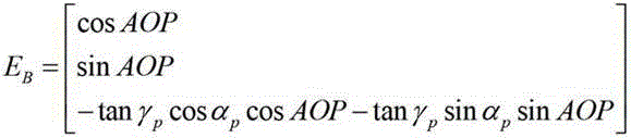
(a2) 基于不同观测方向的偏振方向AOP,建立偏振E矢量在观测坐标系B系下的解算模型:(a2) Based on the polarization direction AOP of different observation directions, the solution model of the polarization E vector in the observation coordinate system B is established:
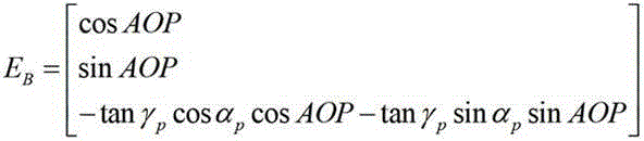
式中,γ p 和ɑ p 分别为观测位置P在观测坐标系B系中的方位角与天顶角;In the formula, γ p and ɑ p are the azimuth angle and zenith angle of the observation position P in the observation coordinate system B, respectively;
(a3) 由于偏振E矢量与太阳矢量互相垂直,因此由多个方向的偏振E矢量建立在观测坐标系B系下的太阳矢量SB优化求解模型:(a3) Since the polarization E vector and the sun vector are perpendicular to each other, the optimal solution model of the sun vector S B under the observation coordinate system B is established by the polarization E vectors in multiple directions:

式中,S B 为太阳矢量,[E B ]为偏振方向图像上不同偏振计算单元对应的偏振E矢量的集合,arg min()为目标取最小值时的求解变量值;s.t.为约束条件;In the formula, S B is the sun vector, [ E B ] is the set of polarization E vectors corresponding to different polarization calculation units on the polarization direction image, arg min() is the solution variable value when the target takes the minimum value; st is the constraint condition;
(a4) 基于偏振光场信息中的偏振度DOP的图像,利用偏振度阈值分割与均值聚类估计法,计算偏振度DOP的图像中偏振度最小的区域中心,进而获得偏振中性点矢量N P ;(a4) Based on the image of the degree of polarization DOP in the polarization light field information, the center of the region with the smallest degree of polarization in the image of the degree of polarization DOP is calculated by using the degree of polarization threshold segmentation and mean clustering estimation method, and then the polarization neutral point vector N is obtained P ;
(a5) 假设天顶方向在观测坐标系B系下的方向矢量为U B ,联立太阳矢量S B 建立观测时刻对应的偏振中性面模型:(a5) Assuming that the direction vector of the zenith direction in the observation coordinate system B is U B , and the simultaneous sun vector S B establishes the polarization neutral plane model corresponding to the observation time:


进一步地,所述第二步的实现步骤如下:Further, the implementation steps of the second step are as follows:
(b1)在不同的观测时刻t, 偏振罗盘获得对应的偏振中性面模型

(b2) 对连续时刻内的偏振中性面进行反演重构并统一映射在地理坐标系下,连续时刻内的偏振中性面相交于观测位置的天顶方向在观测坐标系B系下的方向矢量U B ,即

(b3)假设天顶方向在观测坐标系B系下的方向矢量U B 在偏振罗盘成像面的映射位置坐标为X U ,Y U ,偏振罗盘焦距为f,其映射位置表示为U B (X U ,Y U ,f);基于天顶方向到各个偏振中性面最小映射距离原则,建立天顶映射位置的优化求解模型,即
进一步地,所述第三步的实现步骤如下:Further, the implementation steps of the third step are as follows:
(c1) 基于第二步中求得的天顶方向在观测坐标系B系下的方向矢量U B 在偏振罗盘成像面的映射位置为U B (X U ,Y U ,f),计算不同观测时刻t的偏振中性面的太阳矢量S B (t)的太阳高度角,即
式中,θ h(t)为t时刻太阳矢量的高度角,arccos[]为反余弦函数;In the formula, θ h ( t ) is the altitude angle of the sun vector at time t, and arccos[] is the inverse cosine function;
(c2) 基于球面导航三角形,建立观测位置经纬度与太阳高度角之间的位置关系模型为:sin[θ h(t)]=sinϕsinδ+cosϕcosδcos(λ+15(UT+E)-180°);(c2) Based on the spherical navigation triangle, establish the positional relationship model between the longitude and latitude of the observation position and the solar altitude angle: sin[ θ h ( t )]=sin ϕ sin δ +cos ϕ cos δ cos( λ +15( UT + E )-180°);
其中,ϕ为观测位置纬度,λ为观测位置经度,δ和E分布为观测时刻t对应的太阳赤纬与赤经,UT为观测时间t对应的世界时;Among them, ϕ is the latitude of the observation location, λ is the longitude of the observation location, δ and E distributions are the solar declination and right ascension corresponding to the observation time t, and UT is the universal time corresponding to the observation time t;
(c3) 当观测时刻t个数大于2时,根据不同观测时刻t的位置关系模型对观测位置经度λ、观测位置纬度ϕ解算;(c3) When the number of observation time t is greater than 2, the observation position longitude λ and observation position latitude ϕ are calculated according to the position relationship model at different observation time t;
当观测时刻t的分时个数为N时,建立偏振罗盘定位优化求解模型为:When the number of time-sharing at the observation time t is N, the optimal solution model for the polarization compass positioning is established as follows:

(c4) 根据地球的椭球度对求解得到的观测位置纬度ϕ进行椭球校正,得到最终观测位置纬度

式中,r p 与r e 分别为地球的极地半径与赤道半径。In the formula, r p and r e are the polar radius and equatorial radius of the earth, respectively.
本发明与现有技术相比的优点在于:The advantage of the present invention compared with prior art is:
(1) 现有技术的缺点主要在于其依赖外部仪器提供水平基准信息,从而限制了偏振自主定向与定位方法的精度。首先,外部水平测量仪器(如倾角仪、惯导等)必然会引入水平测量系统误差;同时,偏振罗盘与载体的安装误差,水平仪器的安装误差也参与到定位计算过程中;最后,偏振定位的解算精度受限于水平测量仪器的对太阳高度角的求解精度;(1) The main disadvantage of the existing technology is that it relies on external instruments to provide horizontal reference information, which limits the accuracy of polarization-autonomous orientation and positioning methods. First of all, external level measuring instruments (such as inclinometers, inertial navigation, etc.) will inevitably introduce level measurement system errors; at the same time, the installation error of the polarization compass and the carrier, and the installation error of the level instrument also participate in the positioning calculation process; finally, polarization positioning The solution accuracy of is limited by the solution accuracy of the horizontal measuring instrument to the sun altitude angle;
(2) 与现有技术的缺点相比,本发明不依赖外部仪器提供水平基准信息;(2) Compared with the shortcomings of the prior art, the present invention does not rely on external instruments to provide horizontal reference information;
(3) 与现有技术的缺点相比,发明适用于静态环境下具有高自主定位精度需求的军用或民用载体;(3) Compared with the shortcomings of the existing technology, the invention is suitable for military or civilian carriers with high autonomous positioning accuracy requirements in a static environment;
(4) 本发明之所有存在上述优点,是由于本发明提出通过分时重构建立长时间的偏振中性面观测系统,从而无需借助外部水平基准仪器,实现偏振罗盘的自主定位。(4) All of the above-mentioned advantages of the present invention are due to the fact that the present invention proposes to establish a long-term polarization neutral plane observation system through time-sharing reconstruction, so as to realize the autonomous positioning of the polarization compass without resorting to an external horizontal reference instrument.
附图说明Description of drawings
图1为本发明一种太阳偏振中性面分时反演重构的自主定位方法的设计流程图;Fig. 1 is the design flowchart of the autonomous positioning method of a kind of solar polarization neutral plane time-sharing inversion reconstruction of the present invention;
图2为本发明一种太阳偏振中性面分时反演重构的自主定位方法的中性面重构示意图。Fig. 2 is a schematic diagram of neutral plane reconstruction of an autonomous positioning method for time-sharing inversion and reconstruction of the neutral plane of solar polarization according to the present invention.
具体实施方式Detailed ways
下面结合附图及实施例对本发明进行详细说明。The present invention will be described in detail below in conjunction with the accompanying drawings and embodiments.
如图1所示,本发明公开了一种太阳偏振中性面分时反演重构的自主定位方法。该方法提出通过分时重构建立长时间的偏振中性面观测系统,从而无需借助外部水平基准仪器,实现偏振罗盘的自主定位。As shown in Fig. 1, the present invention discloses an autonomous positioning method for time-sharing inversion and reconstruction of the neutral plane of solar polarization. This method proposes to establish a long-term polarization neutral plane observation system through time-sharing reconstruction, so that the autonomous positioning of the polarization compass can be realized without the help of an external horizontal reference instrument.
太阳光在地球大气层中与大气分子或气溶胶等粒子相互作用发生散射而产生偏振。假设偏振罗盘对大气偏振场成像检偏方向分别为0°,45°,90°和135°时的成像灰度值分别为I(0°),I(45°),I(90°)和I(135°),那么对应的偏振光场信息中偏振度DOP与偏振方向AOP为:Sunlight is polarized when it interacts with particles such as atmospheric molecules or aerosols in the Earth's atmosphere. Assuming that the polarizing compass is used to analyze the polarization field of the atmospheric polarization field at 0°, 45°, 90° and 135°, the gray value of the image is I (0°), I (45°), I (90°) and I (135°), then the degree of polarization DOP and the direction of polarization AOP in the corresponding polarized light field information are:

式中,


在偏振感光坐标系(I系)下,对应的偏振E矢量可以有偏振方向AOP得到:In the polarization sensitive coordinate system (I system), the corresponding polarization E vector can be obtained by the polarization direction AOP:

假设偏振成像位置P对应的在观测坐标系B系的方向矢量为:Assume that the direction vector corresponding to the polarization imaging position P in the observation coordinate system B is:

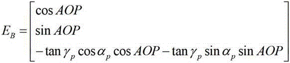
式中,γ p 和ɑ p 分别为观测位置P在B系中的方位角与天顶角。In the formula, γ p and ɑ p are the azimuth angle and zenith angle of the observation position P in the B system, respectively.
然后,在B系中偏振E矢量由其与观测方向之间的垂直关系即E B ⊥P B 求解得到:Then, the polarization E vector in the B system is obtained by solving the vertical relationship between it and the observation direction, that is, E B ⊥ P B :
在偏振罗盘中考虑不同的观测方向的E矢量与太阳矢量垂直即E B ⊥S B ,那么可使用最小二乘优化对太阳矢量在B系中的方向求解:In the polarization compass, the E vector of different observation directions is perpendicular to the sun vector, that is, E B ⊥ S B , then the least square optimization can be used to solve the direction of the sun vector in the B system:

式中,S B 为太阳矢量,[E B ]为不同观测方向的偏振E矢量集合[E B ]=[E B,1,E B,2,E B,3, ... ],arg min()为目标取最小值时的求解变量值。In the formula, S B is the sun vector, [ E B ] is the set of polarized E vectors in different observation directions [ E B ]=[ E B ,1 , E B ,2 , E B ,3 , ... ], arg min () is the solution variable value when the target takes the minimum value.
同时基于偏振度DOP信息,利用偏振度阈值分割与均值聚类估计法,计算偏振度图像中偏振度最小的区域中心,进而获得偏振中性点矢量N P :At the same time, based on the degree of polarization DOP information, the center of the region with the smallest degree of polarization in the degree of polarization image is calculated by using the degree of polarization threshold segmentation and mean clustering estimation method, and then the polarization neutral point vector NP is obtained:

式中, Zeh NP 与Azi NP 分别为中性点区域中心的天顶角与方位角。In the formula, Zeh NP and Azi NP are the zenith angle and azimuth angle of the center of the neutral point area, respectively.
如图2所示,On为观测坐标系原点,S为太阳矢量在观测系下的方向。假设天顶方向在在观测坐标系B系下的方向矢量为U B ,联立太阳矢量S B 建立该观测时刻对应的偏振中性面模型:As shown in Figure 2, On is the origin of the observation coordinate system, and S is the direction of the sun vector under the observation system. Assuming that the direction vector of the zenith direction in the observation coordinate system B is U B , and the simultaneous sun vector S B establishes the polarization neutral plane model corresponding to the observation moment:

式中,
假设偏振罗盘静止放置,随着地球的自转,偏振中性面也随之慢慢发生偏移。在不同的观测时刻t, 偏振罗盘可以获得对应的偏振中性面

将连续时刻内的偏振中性面进行反演重构,统一映射在地理坐标系下(东-北-天坐标系)。它们相交于观测位置的天顶方向U B ,即:Invert and reconstruct the polarization neutral plane in continuous time, and uniformly map it in the geographic coordinate system (east-north-sky coordinate system). They intersect in the zenith direction U B of the observation position, namely:

式中t i 与t j 分别为不同的观测时间,
假设天顶方向U B 在偏振罗盘成像面的映射位置坐标为X U ,Y U ,偏振罗盘焦距为f,天顶方向表示为U B (X U ,Y U ,f)。基于天顶方向坐标到各个偏振中性面最小映射距离原则,建立天顶映射位置的优化求解模型,即:Assume that the coordinates of the mapping position of the zenith direction U B on the imaging plane of the polarization compass are X U , Y U , the focal length of the polarization compass is f , and the zenith direction is expressed as U B ( X U , Y U , f ). Based on the principle of the minimum mapping distance from the zenith direction coordinates to each polarization neutral plane, an optimal solution model for the zenith mapping position is established, namely:

其中N为观测偏振中性面的个数。where N is the number of observed polarization neutral planes.
基于天顶方向U B 在偏振罗盘成像面的映射位置为(X U ,Y U ,f),通过计算太阳矢量与天顶方向之间的夹角获得计算不同时刻t对应的偏振中性面的太阳矢量S B (t)的高度角:Based on the mapping position of the zenith direction U B on the polarization compass imaging plane ( X U , Y U , f ), by calculating the angle between the sun vector and the zenith direction to obtain the polarization neutral plane corresponding to different time t The altitude angle of the sun vector S B ( t ):

式中,θ h(t)为t时刻太阳矢量的高度角,arccos[]为反余弦函数。In the formula, θ h ( t ) is the altitude angle of the sun vector at time t, and arccos[] is the inverse cosine function.
基于球面天文导航三角形,建立观测位置经纬度与太阳高度角之间的位置关系模型为:Based on the spherical astronomical navigation triangle, the positional relationship model between the latitude and longitude of the observation position and the solar altitude angle is established as follows:
sin[θ h(t)]=sinϕsinδ+cosϕcosδcos(λ+15(UT+E)-180°)sin[ θ h ( t )]=sin ϕ sin δ +cos ϕ cos δ cos( λ +15( UT + E )-180°)
其中,ϕ为观测位置纬度,λ为观测位置经度,δ和E分别为观测时刻的太阳赤纬与赤经(由太阳星历得到),UT为观测时间对应的世界时;Among them, ϕ is the latitude of the observation location, λ is the longitude of the observation location, δ and E are the solar declination and right ascension at the observation time (obtained from the solar ephemeris), and UT is the universal time corresponding to the observation time;
当观测时刻t个数大于2时,不同观测时刻t的位置关系模型可对观测位置纬度ϕ与观测位置经度λ解算。当观测时刻t分时个数为N时,建立偏振罗盘定位优化求解模型为:When the number of observation time t is greater than 2, the position relationship model of different observation time t can be solved for the observation position latitude ϕ and observation position longitude λ . When the number of time-sharing at the observation time t is N, the optimal solution model for the polarization compass positioning is established as follows:

最后,根据地球的椭球度对求解得到的观测位置经纬度信息(λ,ϕ)的纬度进行椭球校正,得到最终观测位置经纬度信息
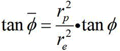
式中,r p 与r e 分别为地球的极地半径与赤道半径。In the formula, r p and r e are the polar radius and equatorial radius of the earth, respectively.
本发明说明书中未作详细描述的内容属于本领域专业技术人员公知的现有技术。本领域的技术人员容易理解,以上所述仅为本发明的较佳实施例而已,并不用以限制本发明,凡在本发明的精神和原则之内所作的任何修改、等同替换和改进等,均应包含在本发明的保护范围之内。The contents not described in detail in the description of the present invention belong to the prior art known to those skilled in the art. It is easy for those skilled in the art to understand that the above descriptions are only preferred embodiments of the present invention, and are not intended to limit the present invention. Any modifications, equivalent replacements and improvements made within the spirit and principles of the present invention, All should be included within the protection scope of the present invention.
Claims (4)








Priority Applications (1)
| Application Number | Priority Date | Filing Date | Title |
|---|---|---|---|
| CN202310010273.3A CN115683091B (en) | 2023-01-05 | 2023-01-05 | An autonomous positioning method based on time-sharing inversion and reconstruction of solar polarization neutral plane |
Applications Claiming Priority (1)
| Application Number | Priority Date | Filing Date | Title |
|---|---|---|---|
| CN202310010273.3A CN115683091B (en) | 2023-01-05 | 2023-01-05 | An autonomous positioning method based on time-sharing inversion and reconstruction of solar polarization neutral plane |
Publications (2)
| Publication Number | Publication Date |
|---|---|
| CN115683091A true CN115683091A (en) | 2023-02-03 |
| CN115683091B CN115683091B (en) | 2023-04-04 |
Family
ID=85057277
Family Applications (1)
| Application Number | Title | Priority Date | Filing Date |
|---|---|---|---|
| CN202310010273.3A Active CN115683091B (en) | 2023-01-05 | 2023-01-05 | An autonomous positioning method based on time-sharing inversion and reconstruction of solar polarization neutral plane |
Country Status (1)
| Country | Link |
|---|---|
| CN (1) | CN115683091B (en) |
Citations (6)
| Publication number | Priority date | Publication date | Assignee | Title |
|---|---|---|---|---|
| CN103759727A (en) * | 2014-01-10 | 2014-04-30 | 大连理工大学 | Navigation and positioning method based on sky polarized light distribution mode |
| CN104613956A (en) * | 2015-01-28 | 2015-05-13 | 南昌大学 | Atmospheric polarization neutral point-based navigation orientation method |
| CN104713555A (en) * | 2015-03-03 | 2015-06-17 | 南昌大学 | Autonomous vehicle navigation method for assisting orientation by applying omnimax neutral point |
| WO2015108591A2 (en) * | 2013-10-22 | 2015-07-23 | Polaris Sensor Technologies Inc. | Sky polarization and sun sensor system and method |
| CN110631567A (en) * | 2019-10-09 | 2019-12-31 | 北京航空航天大学 | A Method of Inversion and Correction of Atmospheric Refraction Error of Differential Sky Polarization Compass |
| DE102018132590A1 (en) * | 2018-12-18 | 2020-06-18 | Valeo Schalter Und Sensoren Gmbh | Determination of an attitude of a vehicle based on sky polarization by acelestial light source |
-
2023
- 2023-01-05 CN CN202310010273.3A patent/CN115683091B/en active Active
Patent Citations (6)
| Publication number | Priority date | Publication date | Assignee | Title |
|---|---|---|---|---|
| WO2015108591A2 (en) * | 2013-10-22 | 2015-07-23 | Polaris Sensor Technologies Inc. | Sky polarization and sun sensor system and method |
| CN103759727A (en) * | 2014-01-10 | 2014-04-30 | 大连理工大学 | Navigation and positioning method based on sky polarized light distribution mode |
| CN104613956A (en) * | 2015-01-28 | 2015-05-13 | 南昌大学 | Atmospheric polarization neutral point-based navigation orientation method |
| CN104713555A (en) * | 2015-03-03 | 2015-06-17 | 南昌大学 | Autonomous vehicle navigation method for assisting orientation by applying omnimax neutral point |
| DE102018132590A1 (en) * | 2018-12-18 | 2020-06-18 | Valeo Schalter Und Sensoren Gmbh | Determination of an attitude of a vehicle based on sky polarization by acelestial light source |
| CN110631567A (en) * | 2019-10-09 | 2019-12-31 | 北京航空航天大学 | A Method of Inversion and Correction of Atmospheric Refraction Error of Differential Sky Polarization Compass |
Non-Patent Citations (2)
| Title |
|---|
| GUANGMIN LI,ET AL.: "Robust Heading Measurement Based on Improved Berry Model for Bionic Polarization Navigation" * |
| 马号;熊剑;郭杭;衷卫声;王娜;: "基于大气偏振光特性辅助定向的自主导航方法" * |
Also Published As
| Publication number | Publication date |
|---|---|
| CN115683091B (en) | 2023-04-04 |
Similar Documents
| Publication | Publication Date | Title |
|---|---|---|
| CN104880191B (en) | A kind of polarization auxiliary navigation method based on solar vector | |
| CN103822629B (en) | Positioning system and its positioning method based on multi-directional polarized light navigation sensor | |
| CN107063170B (en) | Course angle estimation method based on atmospheric polarization angle mould formula under complex environment | |
| CN109459027B (en) | A Navigation Method Based on Polarization-Geomagnetic Vector Compact Combination | |
| CN104880192B (en) | A kind of carrier heading computing method based on polarization compass | |
| CN110631567B (en) | Inversion and correction method for atmospheric refraction error of differential sky polarization compass | |
| CN110887478B (en) | An autonomous navigation and positioning method based on polarization/astronomical assistance | |
| CN114910080B (en) | Three-dimensional navigation attitude determination method based on underwater downlink radiation light intensity and polarized light field | |
| CN106382927A (en) | A star sensor autonomous navigation method based on satellite identification | |
| CN106679645A (en) | Real-time navigation device based on multi-directional polarized light | |
| CN103727937B (en) | Star sensor based naval ship attitude determination method | |
| CN105910606A (en) | Direction adjustment method based on angular velocity difference | |
| CN116045979B (en) | Bionic polarized light course measurement method based on improved polarized field singular point model | |
| CN109470237B (en) | Navigation attitude measurement method based on combination of polarized light and geomagnetism | |
| CN110887472A (en) | A fully autonomous attitude calculation method for deep fusion of polarization-geomagnetic information | |
| CN112129288A (en) | A method and system for pose estimation based on polarized light/geomagnetic heading constraints | |
| CN109459015B (en) | Polarization navigation global autonomous positioning method based on maximum polarization degree observation | |
| CN115540856B (en) | Star sensor autonomous positioning method and system based on starlight three-dimensional refraction reconstruction | |
| CN115164889B (en) | A three-dimensional real-time attitude determination method for polarization compass based on polarization meridian plane | |
| CN114894197B (en) | An underwater polarization autonomous heading calculation method based on real-time tracking of zenith points | |
| CN113819904B (en) | polarization/VIO three-dimensional attitude determination method based on zenith vector | |
| CN108489483B (en) | A single-satellite suboptimal correction algorithm for ship-borne starlight director | |
| CN113375626B (en) | Space vector relative parallelism measuring method based on inertial device | |
| CN108645410B (en) | An astronomical positioning method for ships without altitude observation | |
| CN119642826B (en) | A three-dimensional attitude determination method for a vehicle based on dual-vector characteristics of polarized light fields at night |
Legal Events
| Date | Code | Title | Description |
|---|---|---|---|
| PB01 | Publication | ||
| PB01 | Publication | ||
| SE01 | Entry into force of request for substantive examination | ||
| SE01 | Entry into force of request for substantive examination | ||
| GR01 | Patent grant | ||
| GR01 | Patent grant |