EP0595570B1 - Navigiermodul für ein halbautonomes Fahrzeug - Google Patents
Navigiermodul für ein halbautonomes Fahrzeug Download PDFInfo
- Publication number
- EP0595570B1 EP0595570B1 EP93308470A EP93308470A EP0595570B1 EP 0595570 B1 EP0595570 B1 EP 0595570B1 EP 93308470 A EP93308470 A EP 93308470A EP 93308470 A EP93308470 A EP 93308470A EP 0595570 B1 EP0595570 B1 EP 0595570B1
- Authority
- EP
- European Patent Office
- Prior art keywords
- hex
- safety
- values
- terrain
- hexes
- Prior art date
- Legal status (The legal status is an assumption and is not a legal conclusion. Google has not performed a legal analysis and makes no representation as to the accuracy of the status listed.)
- Expired - Lifetime
Links
Images

Classifications
-
- G—PHYSICS
- G05—CONTROLLING; REGULATING
- G05D—SYSTEMS FOR CONTROLLING OR REGULATING NON-ELECTRIC VARIABLES
- G05D1/00—Control of position, course, altitude or attitude of land, water, air or space vehicles, e.g. using automatic pilots
- G05D1/02—Control of position or course in two dimensions
- G05D1/021—Control of position or course in two dimensions specially adapted to land vehicles
- G05D1/0212—Control of position or course in two dimensions specially adapted to land vehicles with means for defining a desired trajectory
- G05D1/0221—Control of position or course in two dimensions specially adapted to land vehicles with means for defining a desired trajectory involving a learning process
-
- G—PHYSICS
- G05—CONTROLLING; REGULATING
- G05D—SYSTEMS FOR CONTROLLING OR REGULATING NON-ELECTRIC VARIABLES
- G05D1/00—Control of position, course, altitude or attitude of land, water, air or space vehicles, e.g. using automatic pilots
- G05D1/02—Control of position or course in two dimensions
- G05D1/021—Control of position or course in two dimensions specially adapted to land vehicles
- G05D1/0212—Control of position or course in two dimensions specially adapted to land vehicles with means for defining a desired trajectory
- G05D1/0217—Control of position or course in two dimensions specially adapted to land vehicles with means for defining a desired trajectory in accordance with energy consumption, time reduction or distance reduction criteria
-
- G—PHYSICS
- G05—CONTROLLING; REGULATING
- G05D—SYSTEMS FOR CONTROLLING OR REGULATING NON-ELECTRIC VARIABLES
- G05D1/00—Control of position, course, altitude or attitude of land, water, air or space vehicles, e.g. using automatic pilots
- G05D1/02—Control of position or course in two dimensions
- G05D1/021—Control of position or course in two dimensions specially adapted to land vehicles
- G05D1/0231—Control of position or course in two dimensions specially adapted to land vehicles using optical position detecting means
Definitions
- the present invention relates in general to the field of fuzzy logic and more particularly to the use of fuzzy logic to help navigate a semi-autonomous vehicle such as the Mars Rover.
- the image understanding software could determine that a certain region is composed of packed gravel, which would be safe but the degree of belief might not be 100% and the region in question could also contain loose gravel, which is unsafe.
- the information may be incomplete as certain sections of the terrain may not be accessible to the sensors or may contain features which can not be distinguished by the sensors.
- the navigation module In order to navigate in an environment which is not completely known and understood, the navigation module needs to reason with the uncertain information and compute the best path - criteria such as shortest distance, minimum time, and least power consumed - which also guarantees the safety of the vehicle.
- a method for navigating a semi-autonomous vehicle comprising sensing conditions on terrain within sensor range; producing raw image data about said terrain; extracting features from said raw data in the form of feature data for a plurality of local regions on said terrain, and processing said feature data to determine the relative safety of moving said semi-autonomous vehicle from at least one of said local regions to an adjacent local region, characterised by
- a method for navigating a semi-autonomous vehicle comprising sensing conditions on terrain within sensor range; producing raw image data about the terrain; extracting features from the raw data in the form of feature data for a plurality of local regions on the terrain, and processing the feature data to determine the relative safety of moving the vehicle from one local region to an adjacent local region, characterised by
- the fuzzy logic based navigation module of the present invention has input variables defined for terrain type, rock size, and slope between local regions.
- a local region is defined as a hex shaped area within the sensor range of a vehicle to be navigated.
- the fuzzy logic system can be embedded on a microprocessor on board the vehicle. Each hex (or pair of neighboring hexes) has associated with it a value for each of the input variables. These values are determined by an image processing module which is external to the present invention.
- the fuzzy logic system further comprises a set of rules, or knowledge base, organized into a hierarchical structure of five levels. Level 1 determines a regional safety value for a cluster of seven hexes based on terrain type and rock size.
- Level 2 determines a directional safety value for traveling from the center of the cluster to its six adjacent hexes based on regional safety and slope.
- Level 3 determines a new regional safety value for the center hex based on the regional safety of the adjacent hexes.
- Level 4 determines new directional safety values based on the directional safety of adjacent hexes.
- Level 5 determines final directional safety values based on the level 4 values and the regional safety of the center hex.
- Each hex is processed by the fuzzy rule base as the center hex of a cluster and upon processing every hex, a mapping of safety values for moving from every hex to an adjacent hex is produced. With this information, a best path can be selected for getting from one point on the terrain to a target point.
- the fuzzy logic system of the present invention can be built using currently existing tools which allow a developer to write the rules in a high level English like language to be compiled into C-code for a target processor.
- Sensor Module 10 provides raw terrain data to Image Understanding Module 12. This data might originate from a variable depth range camera, 2D stereo camera, or other types of known sensors. Image Understanding Module 12 processes the data transmitted by Sensor Module 10 and extracts certain features that have been identified. These features include terrain type (dust, loose sand, packed sand, loose gravel, packed gravel, and rock), slope, and rocks. Pictures from an orbiter could also be used to facilitate the feature identification and extraction process. After the Image Understanding Module 12 has completed the features extraction from the current sector within sensor range, the feature information is formatted in some predefined manner and then communicated to Navigation Module 14.
- Navigation Module 14 utilizes a priori information (a precomputed path based on pictures collected from an orbiter and relayed to Earth), along with features determined locally by the Sensor Module 10 and Image Understanding Module 12, to compute a local path for the vehicle which minimizes the deviation from the precomputed path while maintaining minimal object clearance, inclination, and other traversal safety parameters.
- the computed safe path is then sent to Guidance Module 16.
- Guidance Module 16 calculates the required steering commands from the path coordinates using the vehicles location and transmits this information to Mobility Module 18.
- Mobility Module 18 receives, processes, and implements the steering commands transmitted by Guidance Module 16 and also monitors the vehicle's motion and manages the interfaces with the lower level systems or modules such as motors, controls, feedback systems, and sensors. Upon completion of local sensor data collection, image processing, navigation, and movements, the vehicle is at a new position and the cycle repeats.
- the focus of the present invention is on Navigation Module 14.
- the particular problem solved by the present invention is how to process the large amount of information extracted by Image Understanding Module 12 concerning the terrain type, slope and rocks within a given sector, in such a way as to provide a useful input to various known path planning algorithms.
- Fuzzy logic is used as the underlying reasoning mechanism to label regions within the sector, as having some degree of safety, thus the present invention is referred to herein as a fuzzy region classifier.
- Other possible parameters besides safety such as fuel consumption, region traversibility, cohesion of terrain type, distance from current to goal hex, and distance from start to current hex could also be used, but the implementation described herein uses safety as the criterion for computing a best path.
- Image Understanding Module 12 is able to analyze features contained in hex shaped areas of a size equal to the resolution of the Image Understanding Module 12, which may be one meter for example.
- Each hex has a terrain type (a coefficient of traction), six slope values (tenths logic knowledge base can also be converted into assembly code for a target processor using Togai InfraLogic FPL (micro Fuzzy Programming Language) Development System.
- Togai InfraLogic FPL micro Fuzzy Programming Language
- This is a set of tools for developing microcomputer based embedded fuzzy logic systems. With the appropriate compilers and/or assemblers, the fuzzy logic system of the present invention can be embedded in a navigation system such as shown in Figure 1.
- Appendix A contains a complete source code listing embodying the present invention. Upon compilation of this source code, an object code version of the program can be run on a target microprocessor to perform the fuzzy region classification given an input set of hexes as explained above. Each hex is evaluated with respect to the rules contained therein and the result is a directional safety value assigned to each pair of adjacent hexes. Appendix A contains the complete description of all of the linguistic variables used and their corresponding termset definitions and a complete description of all of the rules used to determine direct and safety values. Each hex is surrounded by six neighbor hexes and the fuzzy rules take into account not only the characteristics of the hex being classified but also the characteristics of its neighbor hexes.
- the classification scheme of the present invention is divided into a hierarchical structure with five levels. Each level examines certain characteristics of the hexes and possibly the neighbor hexes to determine the safety values for that hex. The results from lower levels of classification are provided as input to a higher level. After describing of meters relative to its six neighbor hexes), a rock value (size in centimeters), and coordinates in a user defined coordinate system.
- fuzzy logic is used to determine a safety value for each hex based on the characteristics of each hex.
- Fuzzy logic is a formulation of logic that deals with fuzzy concepts such as very, few, and many in a rigorous mathematical framework. It utilizes IF ... THEN type rules comprised of linguistic variables.
- a linguistic variable is one whose value is one or more words rather than a number. For example, in the statement "air is hot", the linguistic variable, temperature, has the linguistic value "hot” for air.
- fuzzy logic The mathematical theory of fuzzy logic is well known in the art and numerous references exist which describe the way in which the fuzzy inference process applies a set of fuzzy rules to a set of linguistic input variables (whose values may be certain or fuzzy themselves) to determine crisp (non-fuzzy) values for a set of linguistic output variables.
- Commonly assigned, co-pending patent application Serial no. 07/775,873 provides such a detailed description of the fuzzy inference process.
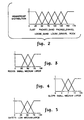
- the terrain input can have a value from 0 to 175. This number represents the type of terrain as determined by the characterization of its coefficient of friction by the image understanding module.
- the final input is slope.
- Figure 4 displays the membership distributions for these classes.
- the domain represents elevation change in tenths of a meter.
- the output of the fuzzy inference process of the present invention is six directional safety values for each hex representing the degree of safety for the vehicle to head in a particular direction from that hex.
- the directional safety has three classes: low, medium and high.
- Figure 5 shows the membership distributions for these three classes.
- the safety value represents degree of confidence, or belief, on a scale of 0 to 100.
- the fuzzy logic knowledge base of the present invention uses over 200 rules organized in a hierarchical structure composed of five levels. Each hex and its surrounding hexes are individually examined with respect to these five levels of rules in order to determine the six directional safety values for the center hex. The rules therefore must be applied as many times as there are hexes input to the system. All of the rules for each of the five levels are contained in Appendix A. The various levels and their functions will next be described.
- Level 1 determines a regional safety value for a hex and its surrounding hexes (a cluster).
- An example of a level one rule is: rule packed_gravel_1_hex0_rule if terrain_type_0 is packed_gravel and rocks_0 is small then S_0_0 is high. end
- the rule has two clauses in the premise. The first clause checks for the terrain type being of class packed_gravel and the second checks for rocks that are small. The degree to which that hex is safe depends on how well the two clauses match.
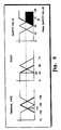
- Figure 6 graphically shows the following example. Suppose the image understanding module characterizes the terrain to have a value of 115 for terrain type and determines that the largest rock is about 25 centimeters in diameter.
- the packed_gravel_1_hex0_rule rule is evaluated and computes a safety value of about 75. Since the terrain_type is only a partial match with the packed_gravel class, the output from this rule is reduced to this degree of match. This safety value is determined by calculating the centroid of the shaded area in Figure 6. Other rules are usually evaluated and contribute to the final output. Multiple shaded areas corresponding to positive rule outputs are combined and the centroid of the combined areas becomes the output value for a safety variable. Other known output defuzzification methods besides centroid can also be used.
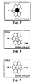
- the result of level 1 rule evaluations is a regional safety value for each hex in the cluster. In Figure 7, if hex 10 has terrain type of dust, then it is not safe with an extremely high degree of confidence irrespective of any other features it might have.
- Level 2 computes six directional safety values for each hex.
- Figure 8 shows an example of a high directional safety value. Travelling from hex 10 to hex 20 would be safe with a very high degree of confidence if the slope is low and there are no features which make either hex 10 or hex 20 unsafe.
- Level 3 examines the cross-coupling of the level 1 regional safety values between adjacent hexes. In Figure 9, if hex 20 is not safe then hex 10 becomes less safe according to the fuzzy rules in level 3. This allows minimal clearance of one hex width from a particularly unsafe hex.
- Level 4 examines the cross-coupling of the level 2 directional safety values.
- the current directional safety value becomes less safe at this level if there is an adjacent directional safety value that is not safe.
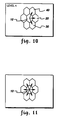
- the level 4 rules would infer that travelling from hex 10 to hex 30 or hex 40 is also unsafe.
- Level 5 examines the cross-coupling of the level 3 regional safety values with the level 4 directional safety values. At level 5 a directional safety value is determined to be unsafe if the hex's safety value is low. In Figure 11, if the regional safety value of hex 10 is low then the directional safety of all six directions is lowered.
- the directional safety values output during level 5 are the final directional safety values computed. These safety values are input to any of a number of known algorithms which can compute a "best" path which maintains a certain level of safety while minimizing the deviation from a pre-computed path based on non-local data as described earlier.
- An example of a simple algorithm is one based on best first search.
Landscapes
- Engineering & Computer Science (AREA)
- Physics & Mathematics (AREA)
- Aviation & Aerospace Engineering (AREA)
- Radar, Positioning & Navigation (AREA)
- Remote Sensing (AREA)
- General Physics & Mathematics (AREA)
- Automation & Control Theory (AREA)
- Electromagnetism (AREA)
- Navigation (AREA)
- Control Of Position, Course, Altitude, Or Attitude Of Moving Bodies (AREA)
- Feedback Control In General (AREA)
- Information Retrieval, Db Structures And Fs Structures Therefor (AREA)
Claims (9)
- Verfahren zum Navigieren eines halbautonomen Fahrzeugs, enthaltend: Abtasten von Zuständen auf dem Terrain innerhalb einer Sensorentfernung; Erzeugen von Rohbilddaten über das Terrain; Extrahieren von Merkmalen aus den Rohdaten in der Form von Merkmalsdaten für mehrere lokale Regionen auf dem Terrain und Verarbeiten der Merkmalsdaten, um die relative Sicherheit des Bewegens des halbautonomen Fahrzeugs von wenigstens einer der lokalen Regionen zu einer benachbarten lokalen Region zu ermitteln, gekennzeichnet durchDefinieren von Variablen für jedes der Merkmale unter Verwendung von Fuzzy-Mitgliedschafts-Gliederungen;Definieren von Fuzzy-Regeln, die einen Sicherheitswert für eine gegebene Kombination von Werten für die Variablen bestimmen; undEingeben von Werten für die eine lokale Region für die Variablen in die Fuzzy-Regeln und Ermitteln eines Ausgangs-Sicherheitswertes unter Verwendung eines Fuzzy-Interferenzprozesses.
- Verfahren nach Anspruch 1, wobei der Schritt des Definierens von Fuzzy-Regeln regionale Sicherheitswerte und direktionale Sicherheitswerte für mehrere lokale Regionen bestimmt; der Schritt des Eingebens von Werten auch das Eingeben von Werten für benachbarte lokale Regionen in die Fuzzy-Regeln und Ermitteln von mehreren direktionalen Sicherheitswerten für die lokale Region enthält; und die Schritte für jede lokale Region auf dem Terrain wiederholt werden.
- Verfahren nach Anspruch 2, wobei die Fuzzy-Regeln in mehreren Ebenen organisiert werden und die Ausgaben von jeder tieferen Ebene Eingaben in eine höhere Ebenen sind.
- Verfahren nach Anspruch 3, wobei regionale Sicherheitswerte und direktionale Sicherheitswerte von einer lokalen Region regionale und direktionale Sicherheitswerte für benachbarte lokale Ebenen an mehreren Pegeln beeinflussen.
- Verfahren zum Navigieren eines halbautonomen Fahrzeugs, enthaltend: Abtasten von Zuständen auf einem Terrain innerhalb einer Sensorentfernung; Erzeugen von Rohbilddaten über das Terrain; Extrahieren von Merkmalen aus den Rohdaten in der Form von Merkmalsdaten für mehrere lokale Regionen auf dem Terrain und Verarbeiten der Merkmalsdaten, um die relative Sicherheit des Bewegens des Fahrzeuges von einer lokalen Region zu einer benachbarten lokalen Region zu bestimmen,
gekennzeichnet durchBetrachten des Terrains, wie es durch ein Bündel bzw. Cluster von sieben Sechsecken mit einem mittleren Sechseck benachbart zu jedem von sechs anderen Sechsecken dargestellt ist;Ermitteln eines regionalen Sicherheitswertes für jedes Sechseck von dem Bündel bzw. Cluster als Antwort auf entsprechende Charakteristiken der Merkmalsdaten für jedes Sechseck von dem Bündel bzw. Cluster; undErmitteln eines entsprechenden direktionalen Sicherheitswertes für eine Bewegung von dem mittleren Sechseck zu jedem der anderen Sechsecke von dem Bündel bzw. Cluster als Antwort auf den regionalen Sicherheitswert von dem mittleren Sechseck und dem entsprechenden benachbarten Sechseck von dem Bündel bzw. Cluster. - Verfahren nach Anspruch 5, wobei ferner ein aktualisierter regionaler Sicherheitswert für das mittlere Sechseck ermittelt wird als Antwort auf die regionalen Sicherheitswerte der anderen Sechsecke von dem Bündel bzw. Cluster.
- Verfahren nach Anspruch 5, wobei ferner ein entsprechender erster, aktualisierter, direktionaler Sicherheitswert ermittelt wird für die Bewegung von dem mittleren Sechseck zu jedem der anderen Sechsecke in dem Bündel bzw. Cluster als Antwort auf die direktionalen Sicherheitswerte.
- Verfahren nach Anspruch 7, wobei ferner ein entsprechender, zweiter, aktualisierter, direktionaler Sicherheitswert ermittelt wird für die Bewegung von dem mittleren Sechseck zu jedem der anderen Sechsecke in dem Bündel bzw. Cluster als Antwort auf die ersten, aktualisierten, direktionalen Sicherheitswerte und dem aktualisierten regionalen Sicherheitswert von dem mittleren Sechseck.
- Verfahren nach Anspruch 5, wobei die Charakteristiken der Merkmalsdaten ausgewählt werden aus der Gruppe bestehend aus Schmutz, losem Sand, verdichtetem Sand, losem Schotter, verdichtetem Schotter, Steinen, Steigung des Terrains zwischen benachbarten Sechsecken und Kombinationen davon.
Applications Claiming Priority (2)
| Application Number | Priority Date | Filing Date | Title |
|---|---|---|---|
| US07/966,472 US5436839A (en) | 1992-10-26 | 1992-10-26 | Navigation module for a semi-autonomous vehicle |
| US966472 | 1992-10-26 |
Publications (3)
| Publication Number | Publication Date |
|---|---|
| EP0595570A2 EP0595570A2 (de) | 1994-05-04 |
| EP0595570A3 EP0595570A3 (de) | 1995-01-04 |
| EP0595570B1 true EP0595570B1 (de) | 1998-01-14 |
Family
ID=25511456
Family Applications (1)
| Application Number | Title | Priority Date | Filing Date |
|---|---|---|---|
| EP93308470A Expired - Lifetime EP0595570B1 (de) | 1992-10-26 | 1993-10-25 | Navigiermodul für ein halbautonomes Fahrzeug |
Country Status (5)
| Country | Link |
|---|---|
| US (1) | US5436839A (de) |
| EP (1) | EP0595570B1 (de) |
| JP (1) | JPH06266406A (de) |
| DE (1) | DE69316318T2 (de) |
| ES (1) | ES2112967T3 (de) |
Families Citing this family (42)
| Publication number | Priority date | Publication date | Assignee | Title |
|---|---|---|---|---|
| US6822563B2 (en) | 1997-09-22 | 2004-11-23 | Donnelly Corporation | Vehicle imaging system with accessory control |
| US5877897A (en) | 1993-02-26 | 1999-03-02 | Donnelly Corporation | Automatic rearview mirror, vehicle lighting control and vehicle interior monitoring system using a photosensor array |
| US6891563B2 (en) | 1996-05-22 | 2005-05-10 | Donnelly Corporation | Vehicular vision system |
| US7655894B2 (en) | 1996-03-25 | 2010-02-02 | Donnelly Corporation | Vehicular image sensing system |
| US5999866A (en) | 1996-11-05 | 1999-12-07 | Carnegie Mellon University | Infrastructure independent position determining system |
| US20030004913A1 (en) * | 2001-07-02 | 2003-01-02 | Koninklijke Philips Electronics N.V. | Vision-based method and apparatus for detecting an event requiring assistance or documentation |
| US20040239675A1 (en) * | 2001-08-10 | 2004-12-02 | Regelous Stephen John | Method of rendering an image and a method of animating a graphics character |
| AU2003225228A1 (en) | 2002-05-03 | 2003-11-17 | Donnelly Corporation | Object detection system for vehicle |
| US7609156B2 (en) * | 2004-04-07 | 2009-10-27 | Jeffrey D Mullen | Advanced cooperative defensive military tactics, armor, and systems |
| US7526103B2 (en) | 2004-04-15 | 2009-04-28 | Donnelly Corporation | Imaging system for vehicle |
| US20080039991A1 (en) * | 2006-08-10 | 2008-02-14 | May Reed R | Methods and systems for providing accurate vehicle positioning |
| WO2008024639A2 (en) | 2006-08-11 | 2008-02-28 | Donnelly Corporation | Automatic headlamp control system |
| US7974460B2 (en) * | 2007-02-06 | 2011-07-05 | Honeywell International Inc. | Method and system for three-dimensional obstacle mapping for navigation of autonomous vehicles |
| US8527155B2 (en) * | 2008-06-27 | 2013-09-03 | Caterpillar Inc. | Worksite avoidance system |
| US8073609B2 (en) * | 2008-12-17 | 2011-12-06 | Caterpillar Inc. | Slippage condition response system |
| US8140239B2 (en) | 2008-12-17 | 2012-03-20 | Caterpillar Inc. | Slippage condition response system |
| US8855847B2 (en) * | 2012-01-20 | 2014-10-07 | Toyota Motor Engineering & Manufacturing North America, Inc. | Intelligent navigation system |
| US9097520B2 (en) | 2013-06-12 | 2015-08-04 | Caterpillar Inc. | System and method for mapping a raised contour |
| JP6035209B2 (ja) * | 2013-07-11 | 2016-11-30 | ヤマハ発動機株式会社 | ナビゲーション装置、シミュレーション装置、移動装置およびナビゲーション方法 |
| US9177481B2 (en) * | 2013-12-13 | 2015-11-03 | Sikorsky Aircraft Corporation | Semantics based safe landing area detection for an unmanned vehicle |
| US9304515B2 (en) | 2014-04-24 | 2016-04-05 | Lenovo Enterprise Solutions (Singapore) Pte. Ltd. | Regional operation modes for autonomous vehicles |
| US9349284B2 (en) | 2014-04-24 | 2016-05-24 | International Business Machines Corporation | Regional driving trend modification using autonomous vehicles |
| US10319039B1 (en) | 2014-05-20 | 2019-06-11 | State Farm Mutual Automobile Insurance Company | Accident fault determination for autonomous vehicles |
| US11669090B2 (en) | 2014-05-20 | 2023-06-06 | State Farm Mutual Automobile Insurance Company | Autonomous vehicle operation feature monitoring and evaluation of effectiveness |
| US9972054B1 (en) | 2014-05-20 | 2018-05-15 | State Farm Mutual Automobile Insurance Company | Accident fault determination for autonomous vehicles |
| US10354330B1 (en) | 2014-05-20 | 2019-07-16 | State Farm Mutual Automobile Insurance Company | Autonomous feature use monitoring and insurance pricing |
| US10599155B1 (en) | 2014-05-20 | 2020-03-24 | State Farm Mutual Automobile Insurance Company | Autonomous vehicle operation feature monitoring and evaluation of effectiveness |
| US10373259B1 (en) | 2014-05-20 | 2019-08-06 | State Farm Mutual Automobile Insurance Company | Fully autonomous vehicle insurance pricing |
| US10185999B1 (en) | 2014-05-20 | 2019-01-22 | State Farm Mutual Automobile Insurance Company | Autonomous feature use monitoring and telematics |
| US9786154B1 (en) | 2014-07-21 | 2017-10-10 | State Farm Mutual Automobile Insurance Company | Methods of facilitating emergency assistance |
| US10241509B1 (en) | 2014-11-13 | 2019-03-26 | State Farm Mutual Automobile Insurance Company | Autonomous vehicle control assessment and selection |
| US11107365B1 (en) | 2015-08-28 | 2021-08-31 | State Farm Mutual Automobile Insurance Company | Vehicular driver evaluation |
| US10134278B1 (en) | 2016-01-22 | 2018-11-20 | State Farm Mutual Automobile Insurance Company | Autonomous vehicle application |
| US11719545B2 (en) | 2016-01-22 | 2023-08-08 | Hyundai Motor Company | Autonomous vehicle component damage and salvage assessment |
| US10503168B1 (en) | 2016-01-22 | 2019-12-10 | State Farm Mutual Automotive Insurance Company | Autonomous vehicle retrieval |
| US10395332B1 (en) | 2016-01-22 | 2019-08-27 | State Farm Mutual Automobile Insurance Company | Coordinated autonomous vehicle automatic area scanning |
| US9940834B1 (en) | 2016-01-22 | 2018-04-10 | State Farm Mutual Automobile Insurance Company | Autonomous vehicle application |
| US11242051B1 (en) | 2016-01-22 | 2022-02-08 | State Farm Mutual Automobile Insurance Company | Autonomous vehicle action communications |
| US11441916B1 (en) | 2016-01-22 | 2022-09-13 | State Farm Mutual Automobile Insurance Company | Autonomous vehicle trip routing |
| US10324463B1 (en) | 2016-01-22 | 2019-06-18 | State Farm Mutual Automobile Insurance Company | Autonomous vehicle operation adjustment based upon route |
| CN109840643B (zh) * | 2017-11-24 | 2021-05-11 | 北京自动化控制设备研究所 | 一种复合导航融合算法的性能评估方法 |
| US11270132B2 (en) * | 2018-10-26 | 2022-03-08 | Cartica Ai Ltd | Vehicle to vehicle communication and signatures |
Family Cites Families (8)
| Publication number | Priority date | Publication date | Assignee | Title |
|---|---|---|---|---|
| JPS63314618A (ja) * | 1987-06-17 | 1988-12-22 | Nissan Motor Co Ltd | 自律走行車両制御装置 |
| JPH0820265B2 (ja) * | 1987-07-10 | 1996-03-04 | アイシン・エィ・ダブリュ株式会社 | 車両用ナビゲーション装置 |
| JP2669031B2 (ja) * | 1989-02-28 | 1997-10-27 | 日産自動車株式会社 | 自律走行車両 |
| JP2669074B2 (ja) * | 1989-09-27 | 1997-10-27 | 日産自動車株式会社 | 自律走行車両の車速感応操舵制御装置 |
| US5170352A (en) * | 1990-05-07 | 1992-12-08 | Fmc Corporation | Multi-purpose autonomous vehicle with path plotting |
| DE69232261T2 (de) * | 1991-11-01 | 2002-07-25 | Motorola, Inc. | Sensorsystem mit verbesserter genauigkeit zur fahrzeugnavigation |
| JPH06504132A (ja) * | 1991-11-01 | 1994-05-12 | モトローラ・インコーポレイテッド | 自動車経路ガイダンス・システム |
| US5283575A (en) * | 1991-11-08 | 1994-02-01 | Zexel Corporation | System and method for locating a travelling vehicle |
-
1992
- 1992-10-26 US US07/966,472 patent/US5436839A/en not_active Expired - Lifetime
-
1993
- 1993-10-25 ES ES93308470T patent/ES2112967T3/es not_active Expired - Lifetime
- 1993-10-25 EP EP93308470A patent/EP0595570B1/de not_active Expired - Lifetime
- 1993-10-25 JP JP5265940A patent/JPH06266406A/ja active Pending
- 1993-10-25 DE DE69316318T patent/DE69316318T2/de not_active Expired - Fee Related
Also Published As
| Publication number | Publication date |
|---|---|
| JPH06266406A (ja) | 1994-09-22 |
| DE69316318T2 (de) | 1998-08-13 |
| ES2112967T3 (es) | 1998-04-16 |
| EP0595570A2 (de) | 1994-05-04 |
| DE69316318D1 (de) | 1998-02-19 |
| EP0595570A3 (de) | 1995-01-04 |
| US5436839A (en) | 1995-07-25 |
Similar Documents
| Publication | Publication Date | Title |
|---|---|---|
| EP0595570B1 (de) | Navigiermodul für ein halbautonomes Fahrzeug | |
| Seraji et al. | Behavior-based robot navigation on challenging terrain: A fuzzy logic approach | |
| Yahja et al. | Framed-quadtree path planning for mobile robots operating in sparse environments | |
| Thompson | The navigation system of the JPL robot | |
| Paden et al. | A survey of motion planning and control techniques for self-driving urban vehicles | |
| Harmon | The ground surveillance robot (GSR): An autonomous vehicle designed to transit unknown terrain | |
| Lowrie et al. | The autonomous land vehicle (ALV) preliminary road-following demonstration | |
| Miller et al. | Cornell university's 2005 DARPA grand challenge entry | |
| De Oliveira et al. | Trajectory planning for autonomous cars in low-structured and unstructured environments: A systematic review | |
| CN120560273A (zh) | 一种基于数字矿山的采矿设备协同控制系统 | |
| Haït et al. | Robust motion planning for rough terrain navigation | |
| Stentz | The NAVLAB system for mobile robot navigation | |
| Toupet et al. | Enhanced Autonomous Navigation on the Perseverance Mars Rover | |
| Wang et al. | Toward efficient trajectory planning based on deterministic sampling and optimization | |
| Devy et al. | On autonomous navigation in a natural environment | |
| Kak et al. | Experiments in the integration of world knowledge with sensory information for mobile robots | |
| Leighty | Darpa alv (autonomous land vehicle) summary | |
| Jerome et al. | A real-time framework for intermediate map construction and kinematically feasible off-road planning without osm | |
| Andersson et al. | Symbolic feedback control for navigation | |
| Kueviakoe et al. | Comparison of interval constraint propagation algorithms for vehicle localization | |
| Shitsukane | Fuzzy logic model for obstacles avoidance mobile robot in static unknown environment | |
| Taş | Integrating combinatorial reasoning and continuous methods for optimal motion planning of autonomous vehicles | |
| Furio et al. | SmartExplorer1. 0: a novel intelligent framework for path planning in Robotics | |
| CHERIF et al. | Motion planning for an all-terrain autonomous vehicle | |
| Doshi et al. | Reasoning with inaccurate spatial knowledge |
Legal Events
| Date | Code | Title | Description |
|---|---|---|---|
| PUAI | Public reference made under article 153(3) epc to a published international application that has entered the european phase |
Free format text: ORIGINAL CODE: 0009012 |
|
| AK | Designated contracting states |
Kind code of ref document: A2 Designated state(s): DE ES FR GB IT |
|
| PUAL | Search report despatched |
Free format text: ORIGINAL CODE: 0009013 |
|
| AK | Designated contracting states |
Kind code of ref document: A3 Designated state(s): DE ES FR GB IT |
|
| 17P | Request for examination filed |
Effective date: 19950704 |
|
| 17Q | First examination report despatched |
Effective date: 19960417 |
|
| GRAG | Despatch of communication of intention to grant |
Free format text: ORIGINAL CODE: EPIDOS AGRA |
|
| GRAG | Despatch of communication of intention to grant |
Free format text: ORIGINAL CODE: EPIDOS AGRA |
|
| GRAH | Despatch of communication of intention to grant a patent |
Free format text: ORIGINAL CODE: EPIDOS IGRA |
|
| GRAH | Despatch of communication of intention to grant a patent |
Free format text: ORIGINAL CODE: EPIDOS IGRA |
|
| GRAA | (expected) grant |
Free format text: ORIGINAL CODE: 0009210 |
|
| AK | Designated contracting states |
Kind code of ref document: B1 Designated state(s): DE ES FR GB IT |
|
| REF | Corresponds to: |
Ref document number: 69316318 Country of ref document: DE Date of ref document: 19980219 |
|
| ET | Fr: translation filed | ||
| ITF | It: translation for a ep patent filed | ||
| REG | Reference to a national code |
Ref country code: ES Ref legal event code: FG2A Ref document number: 2112967 Country of ref document: ES Kind code of ref document: T3 |
|
| PLBE | No opposition filed within time limit |
Free format text: ORIGINAL CODE: 0009261 |
|
| 26N | No opposition filed | ||
| REG | Reference to a national code |
Ref country code: GB Ref legal event code: 732E |
|
| REG | Reference to a national code |
Ref country code: GB Ref legal event code: IF02 |
|
| REG | Reference to a national code |
Ref country code: FR Ref legal event code: TP |
|
| PGFP | Annual fee paid to national office [announced via postgrant information from national office to epo] |
Ref country code: FR Payment date: 20021002 Year of fee payment: 10 |
|
| PGFP | Annual fee paid to national office [announced via postgrant information from national office to epo] |
Ref country code: GB Payment date: 20021016 Year of fee payment: 10 |
|
| PGFP | Annual fee paid to national office [announced via postgrant information from national office to epo] |
Ref country code: DE Payment date: 20021031 Year of fee payment: 10 |
|
| PGFP | Annual fee paid to national office [announced via postgrant information from national office to epo] |
Ref country code: ES Payment date: 20021106 Year of fee payment: 10 |
|
| PG25 | Lapsed in a contracting state [announced via postgrant information from national office to epo] |
Ref country code: GB Free format text: LAPSE BECAUSE OF NON-PAYMENT OF DUE FEES Effective date: 20031025 |
|
| PG25 | Lapsed in a contracting state [announced via postgrant information from national office to epo] |
Ref country code: ES Free format text: LAPSE BECAUSE OF NON-PAYMENT OF DUE FEES Effective date: 20031027 |
|
| PG25 | Lapsed in a contracting state [announced via postgrant information from national office to epo] |
Ref country code: DE Free format text: LAPSE BECAUSE OF NON-PAYMENT OF DUE FEES Effective date: 20040501 |
|
| GBPC | Gb: european patent ceased through non-payment of renewal fee |
Effective date: 20031025 |
|
| PG25 | Lapsed in a contracting state [announced via postgrant information from national office to epo] |
Ref country code: FR Free format text: LAPSE BECAUSE OF NON-PAYMENT OF DUE FEES Effective date: 20040630 |
|
| REG | Reference to a national code |
Ref country code: FR Ref legal event code: ST |
|
| REG | Reference to a national code |
Ref country code: ES Ref legal event code: FD2A Effective date: 20031027 |
|
| PGFP | Annual fee paid to national office [announced via postgrant information from national office to epo] |
Ref country code: IT Payment date: 20061031 Year of fee payment: 14 |
|
| PG25 | Lapsed in a contracting state [announced via postgrant information from national office to epo] |
Ref country code: IT Free format text: LAPSE BECAUSE OF NON-PAYMENT OF DUE FEES Effective date: 20071025 |