EP0635773B1 - Procédé d'établissement d'une carte de l'environnement et de détermination d'une position dans l'environnement au moyen d'un appareil automoteur - Google Patents
Procédé d'établissement d'une carte de l'environnement et de détermination d'une position dans l'environnement au moyen d'un appareil automoteur Download PDFInfo
- Publication number
- EP0635773B1 EP0635773B1 EP94110598A EP94110598A EP0635773B1 EP 0635773 B1 EP0635773 B1 EP 0635773B1 EP 94110598 A EP94110598 A EP 94110598A EP 94110598 A EP94110598 A EP 94110598A EP 0635773 B1 EP0635773 B1 EP 0635773B1
- Authority
- EP
- European Patent Office
- Prior art keywords
- unit
- landmark
- distance
- self
- positional
- Prior art date
- Legal status (The legal status is an assumption and is not a legal conclusion. Google has not performed a legal analysis and makes no representation as to the accuracy of the status listed.)
- Expired - Lifetime
Links
- 238000004519 manufacturing process Methods 0.000 title claims description 3
- 238000000034 method Methods 0.000 claims description 36
- 238000012937 correction Methods 0.000 claims description 14
- 238000005259 measurement Methods 0.000 claims description 14
- 239000011159 matrix material Substances 0.000 claims description 4
- 238000013459 approach Methods 0.000 description 3
- 230000015572 biosynthetic process Effects 0.000 description 3
- 230000001419 dependent effect Effects 0.000 description 2
- 230000002349 favourable effect Effects 0.000 description 2
- 230000004927 fusion Effects 0.000 description 2
- 238000011160 research Methods 0.000 description 2
- 239000000523 sample Substances 0.000 description 2
- 238000011161 development Methods 0.000 description 1
- 230000018109 developmental process Effects 0.000 description 1
- 230000006870 function Effects 0.000 description 1
- 230000004807 localization Effects 0.000 description 1
- 230000015654 memory Effects 0.000 description 1
- 238000012545 processing Methods 0.000 description 1
Images

Classifications
-
- G—PHYSICS
- G01—MEASURING; TESTING
- G01S—RADIO DIRECTION-FINDING; RADIO NAVIGATION; DETERMINING DISTANCE OR VELOCITY BY USE OF RADIO WAVES; LOCATING OR PRESENCE-DETECTING BY USE OF THE REFLECTION OR RERADIATION OF RADIO WAVES; ANALOGOUS ARRANGEMENTS USING OTHER WAVES
- G01S13/00—Systems using the reflection or reradiation of radio waves, e.g. radar systems; Analogous systems using reflection or reradiation of waves whose nature or wavelength is irrelevant or unspecified
- G01S13/88—Radar or analogous systems specially adapted for specific applications
- G01S13/89—Radar or analogous systems specially adapted for specific applications for mapping or imaging
-
- B—PERFORMING OPERATIONS; TRANSPORTING
- B25—HAND TOOLS; PORTABLE POWER-DRIVEN TOOLS; MANIPULATORS
- B25J—MANIPULATORS; CHAMBERS PROVIDED WITH MANIPULATION DEVICES
- B25J13/00—Controls for manipulators
- B25J13/08—Controls for manipulators by means of sensing devices, e.g. viewing or touching devices
- B25J13/088—Controls for manipulators by means of sensing devices, e.g. viewing or touching devices with position, velocity or acceleration sensors
- B25J13/089—Determining the position of the robot with reference to its environment
-
- G—PHYSICS
- G01—MEASURING; TESTING
- G01S—RADIO DIRECTION-FINDING; RADIO NAVIGATION; DETERMINING DISTANCE OR VELOCITY BY USE OF RADIO WAVES; LOCATING OR PRESENCE-DETECTING BY USE OF THE REFLECTION OR RERADIATION OF RADIO WAVES; ANALOGOUS ARRANGEMENTS USING OTHER WAVES
- G01S13/00—Systems using the reflection or reradiation of radio waves, e.g. radar systems; Analogous systems using reflection or reradiation of waves whose nature or wavelength is irrelevant or unspecified
- G01S13/88—Radar or analogous systems specially adapted for specific applications
- G01S13/93—Radar or analogous systems specially adapted for specific applications for anti-collision purposes
- G01S13/931—Radar or analogous systems specially adapted for specific applications for anti-collision purposes of land vehicles
-
- G—PHYSICS
- G05—CONTROLLING; REGULATING
- G05D—SYSTEMS FOR CONTROLLING OR REGULATING NON-ELECTRIC VARIABLES
- G05D1/00—Control of position, course, altitude or attitude of land, water, air or space vehicles, e.g. using automatic pilots
- G05D1/02—Control of position or course in two dimensions
- G05D1/021—Control of position or course in two dimensions specially adapted to land vehicles
- G05D1/0268—Control of position or course in two dimensions specially adapted to land vehicles using internal positioning means
- G05D1/0274—Control of position or course in two dimensions specially adapted to land vehicles using internal positioning means using mapping information stored in a memory device
-
- G—PHYSICS
- G01—MEASURING; TESTING
- G01S—RADIO DIRECTION-FINDING; RADIO NAVIGATION; DETERMINING DISTANCE OR VELOCITY BY USE OF RADIO WAVES; LOCATING OR PRESENCE-DETECTING BY USE OF THE REFLECTION OR RERADIATION OF RADIO WAVES; ANALOGOUS ARRANGEMENTS USING OTHER WAVES
- G01S13/00—Systems using the reflection or reradiation of radio waves, e.g. radar systems; Analogous systems using reflection or reradiation of waves whose nature or wavelength is irrelevant or unspecified
- G01S13/88—Radar or analogous systems specially adapted for specific applications
- G01S13/881—Radar or analogous systems specially adapted for specific applications for robotics
-
- G—PHYSICS
- G01—MEASURING; TESTING
- G01S—RADIO DIRECTION-FINDING; RADIO NAVIGATION; DETERMINING DISTANCE OR VELOCITY BY USE OF RADIO WAVES; LOCATING OR PRESENCE-DETECTING BY USE OF THE REFLECTION OR RERADIATION OF RADIO WAVES; ANALOGOUS ARRANGEMENTS USING OTHER WAVES
- G01S13/00—Systems using the reflection or reradiation of radio waves, e.g. radar systems; Analogous systems using reflection or reradiation of waves whose nature or wavelength is irrelevant or unspecified
- G01S13/88—Radar or analogous systems specially adapted for specific applications
- G01S13/93—Radar or analogous systems specially adapted for specific applications for anti-collision purposes
- G01S13/931—Radar or analogous systems specially adapted for specific applications for anti-collision purposes of land vehicles
- G01S2013/9323—Alternative operation using light waves
-
- G—PHYSICS
- G01—MEASURING; TESTING
- G01S—RADIO DIRECTION-FINDING; RADIO NAVIGATION; DETERMINING DISTANCE OR VELOCITY BY USE OF RADIO WAVES; LOCATING OR PRESENCE-DETECTING BY USE OF THE REFLECTION OR RERADIATION OF RADIO WAVES; ANALOGOUS ARRANGEMENTS USING OTHER WAVES
- G01S13/00—Systems using the reflection or reradiation of radio waves, e.g. radar systems; Analogous systems using reflection or reradiation of waves whose nature or wavelength is irrelevant or unspecified
- G01S13/88—Radar or analogous systems specially adapted for specific applications
- G01S13/93—Radar or analogous systems specially adapted for specific applications for anti-collision purposes
- G01S13/931—Radar or analogous systems specially adapted for specific applications for anti-collision purposes of land vehicles
- G01S2013/9324—Alternative operation using ultrasonic waves
-
- G—PHYSICS
- G05—CONTROLLING; REGULATING
- G05D—SYSTEMS FOR CONTROLLING OR REGULATING NON-ELECTRIC VARIABLES
- G05D1/00—Control of position, course, altitude or attitude of land, water, air or space vehicles, e.g. using automatic pilots
- G05D1/02—Control of position or course in two dimensions
- G05D1/021—Control of position or course in two dimensions specially adapted to land vehicles
- G05D1/0231—Control of position or course in two dimensions specially adapted to land vehicles using optical position detecting means
- G05D1/0238—Control of position or course in two dimensions specially adapted to land vehicles using optical position detecting means using obstacle or wall sensors
- G05D1/024—Control of position or course in two dimensions specially adapted to land vehicles using optical position detecting means using obstacle or wall sensors in combination with a laser
-
- G—PHYSICS
- G05—CONTROLLING; REGULATING
- G05D—SYSTEMS FOR CONTROLLING OR REGULATING NON-ELECTRIC VARIABLES
- G05D1/00—Control of position, course, altitude or attitude of land, water, air or space vehicles, e.g. using automatic pilots
- G05D1/02—Control of position or course in two dimensions
- G05D1/021—Control of position or course in two dimensions specially adapted to land vehicles
- G05D1/0255—Control of position or course in two dimensions specially adapted to land vehicles using acoustic signals, e.g. ultra-sonic singals
-
- G—PHYSICS
- G05—CONTROLLING; REGULATING
- G05D—SYSTEMS FOR CONTROLLING OR REGULATING NON-ELECTRIC VARIABLES
- G05D1/00—Control of position, course, altitude or attitude of land, water, air or space vehicles, e.g. using automatic pilots
- G05D1/02—Control of position or course in two dimensions
- G05D1/021—Control of position or course in two dimensions specially adapted to land vehicles
- G05D1/0268—Control of position or course in two dimensions specially adapted to land vehicles using internal positioning means
- G05D1/0272—Control of position or course in two dimensions specially adapted to land vehicles using internal positioning means comprising means for registering the travel distance, e.g. revolutions of wheels
Definitions
- the present invention relates to a method for creating an environment map and for determining an own position in the environment by a self-propelled unit
- the invention has for its object a method for creating a map of the area and to determine your own position to specify for those cases where the card creation and the location of the mobile unit is not complete are decoupled from each other.
- the start card is known.
- R (k + 1) 0 preferably applies.
- the process can be repeated cyclically.
- FIG. 1 shows a self-moving unit in an environment.
- Figure 2 shows the distribution of the system error.
- Figure 1 is an example of the implementation of the invention Procedure illustrated. It is a mobile unit E shown in different positions for the Methods according to the invention are characteristic. Still is to recognize a landmark L, the location of which after the inventive method is determined.
- the mobile unit E At the beginning of their movement, for example, is here the mobile unit E in a position P1K, which with a Uncertainty U1K is afflicted. This positional uncertainty is represented by an ellipse.
- This position P2P is a predicted position, i.e. due to the measurements with, for example, an odometer should be in Relative to the starting position P1K the mobile unit is now at the P2P position. However, this position does not correspond the real location of the unit in the area since the Path measurement is faulty.
- the position is P2P for example in an area map in one Orientation calculator of the mobile unit as current position saved and as current position in the area map registered.
- Position P2P is a distance MP from the supposed position LP of the predicted the landmark.
- the location In this case, the LP of the landmark L has one with an ellipse represented uncertainty ULP.
- the P2P position is not the real position, which is taken up by the unit. In reality it is at position P2R.
- a distance measuring device for example a laser radar or an ultrasonic sensor
- the real distance of the Unit MR determined for the location of the landmark LR.
- neither the P2R position nor the LR position of the Landmarks have an uncertainty because this is the real positions. If distance measuring devices, the have an error, would be used here. However, its processing is not necessary to carry out the method according to the invention.
- the position of a mobile unit in Form of coordinates and in the form of an orientation in the coordinate system indicates an angle of rotation of the unit. From this you can see that a distance measurement is also dependent from the rotating orientation of the mobile unit in one Coordinate system is. For example, these are rotational orientations and the distance when correcting the position and the Landmark of the mobile unit to be considered.
- the real distance MR is now compared with the predicted one
- the distance is compared and, for example, the difference educated.
- This difference becomes dependent on the positional uncertainty ULP and the position uncertainty U2P split and with the respective share the location of the landmark and the position of the mobile unit in the area map corrected.
- the position LK is then obtained for the landmark with an uncertainty ULK, it should be noted that the Uncertainty ULK is less than the uncertainty ULP.
- Procedure the position P2K with an uncertainty U2K again, this uncertainty U2K is less than the uncertainty U2P.
- Figure 2 shows the distribution of the system error according to the inventive method.
- the real measurement MR and the predicted distance measurement MP are shown. The difference between these two distances results, for example, in the system error S.
- This system error is now divided into a position correction LKO and a position correction PK.
- the division is based on the size of the respective uncertainty with which the position determination or the position determination is afflicted.
- With the position correction LKO the position of a landmark is now corrected and with the position correction PK the position of the mobile unit in the area map is redefined.
- both the position of the mobile unit in a coordinate system at a specific time and the direction of rotation of the mobile unit must be taken into account in the correction.
- the respective positions can then be corrected by applying the corresponding angle functions to the coordinate values.
Landscapes
- Engineering & Computer Science (AREA)
- Remote Sensing (AREA)
- Radar, Positioning & Navigation (AREA)
- Physics & Mathematics (AREA)
- General Physics & Mathematics (AREA)
- Electromagnetism (AREA)
- Computer Networks & Wireless Communication (AREA)
- Mechanical Engineering (AREA)
- Robotics (AREA)
- Human Computer Interaction (AREA)
- Aviation & Aerospace Engineering (AREA)
- Automation & Control Theory (AREA)
- Control Of Position, Course, Altitude, Or Attitude Of Moving Bodies (AREA)
Claims (8)
- Procédé d'établissement d'une carte de l'environnement et de détermination d'une position propre d'une unité automobile dans un environnement à l'aide de l'unité automobile, dans lequela) à partir d'une position de départ de l'unité automobile, une modification de position est réalisée et est déterminée par au moins un premier moyen de mesure disposé sur l'unité ;b) une première position propre (P1K) de l'unité automobile relativement à la position de départ est déterminée en tenant compte d'une incertitude de position (U1K) de l'unité automobile ;c) un écartement de départ d'un point de repère est mesuré par un deuxième moyen de mesure disposé sur l'unité automobile ;d) en tenant compte de l'incertitude de position et de l'écartement de départ par rapport au point de repère (LP), un premier écartement avec une incertitude de situation (ULP) est constaté entre l'unité automobile et le point de repère ;e) la première position propre (P1K) et le point de repère pouvant être déterminé à partir du premier écartement par rapport à l'unité automobile forment une carte de l'environnement ;f) en s'appuyant sur une autre modification de position de l'unité automobile déterminée par le premier moyen de mesure, une deuxième position propre (P2P) est déterminée relativement à la première position propre (P1K) en tenant compte de l'incertitude de position (U2P) de l'unité automobile ;g) en s'appuyant sur la deuxième position propre, un premier deuxième écartement (MP) est déterminé à l'avance par rapport au point de repère à l'aide de la carte de l'environnement ;h) un deuxième deuxième écartement (MR) est mesuré entre l'unité automobile et le point de repère ;i) une différence () est déterminée comme erreur du système entre le premier deuxième écartement (MP) et le deuxième deuxième écartement (MR) ;
 j) la différence (
 - Procédé selon la revendication 1, dans lequel plusieurs points de repère sont pris en compte en même temps.
- Procédé selon la revendication 1 ou 2, dans lequel les étapes f) à j) sont appliquées de façon itérative et ainsi la carte de l'environnement est affinée par d'autres modifications de position de l'unité automobile.
- Procédé selon l'une des revendications 1 à 3, dans lequel une carte de l'environnement est prédéfinie.
- Procédé selon l'une des revendications précédentes, dans lequel une situation d'au moins un point de repère détecté en plus est enregistré dans la carte de l'environnement.
- Procédé selon l'une au moins des revendications précédentes, dans lequel le moyen de mesure est un appareil de mesure de distance.
- Procédé selon l'une des revendications précédentes, dans lequel la correction de situation (LKO)et la correction de position (PK)
 sont déterminées par
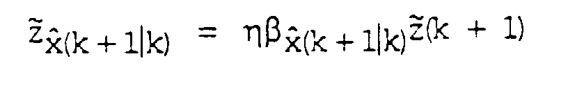
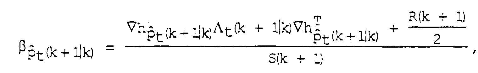 une incertitude de position
 une incertitude de situation
 une erreur du système
 une erreur de mesure R (k+1) et avec
-
- une différence de mesure (MR-MP) par rapport au temps k+1,
-
- un écartement du point de repère déterminé à l'avance calculé
(MP) par rapport au temps k+1 avec
- x and(k + 1|k)
- une position propre déterminée à l'avance (P2P) de l'unité par rapport au temps k+1,
- p andt(k + 1|k)
- une position de points de repère déterminée à l'avance (LP) de
l'unité par rapport au temps k+1,

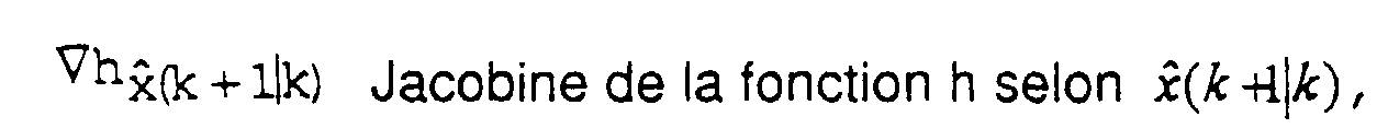
- P(k + 1|k)
- matrice de covariance (U2P) de x and(k + 1|k) par rapport au temps k+1,
- Λt(k + 1|k)
- matrice de covariance (ULP) de p andt (k + 1|k) par rapport au temps k+1,
- η
- facteur de convergence avec 0 ≤ η ≤ 1,
-
- Procédé selon la revendication 7,
dans lequel l'équation R (k+1) = 0 s'applique.
Applications Claiming Priority (2)
| Application Number | Priority Date | Filing Date | Title |
|---|---|---|---|
| DE4324531 | 1993-07-21 | ||
| DE4324531A DE4324531C1 (de) | 1993-07-21 | 1993-07-21 | Verfahren zur Erstellung einer Umgebungskarte und zur Bestimmung einer Eigenposition in der Umgebung durch eine selbstbewegliche Einheit |
Publications (3)
| Publication Number | Publication Date |
|---|---|
| EP0635773A2 EP0635773A2 (fr) | 1995-01-25 |
| EP0635773A3 EP0635773A3 (fr) | 1996-02-14 |
| EP0635773B1 true EP0635773B1 (fr) | 1999-09-29 |
Family
ID=6493395
Family Applications (1)
| Application Number | Title | Priority Date | Filing Date |
|---|---|---|---|
| EP94110598A Expired - Lifetime EP0635773B1 (fr) | 1993-07-21 | 1994-07-07 | Procédé d'établissement d'une carte de l'environnement et de détermination d'une position dans l'environnement au moyen d'un appareil automoteur |
Country Status (3)
| Country | Link |
|---|---|
| EP (1) | EP0635773B1 (fr) |
| DE (2) | DE4324531C1 (fr) |
| ES (1) | ES2138016T3 (fr) |
Cited By (1)
| Publication number | Priority date | Publication date | Assignee | Title |
|---|---|---|---|---|
| EP2752726A1 (fr) | 2013-01-08 | 2014-07-09 | Cleanfix Reinigungssysteme AG | Machine de traitement de sol et procédé de traitement de surfaces de sol |
Families Citing this family (14)
| Publication number | Priority date | Publication date | Assignee | Title |
|---|---|---|---|---|
| DE4415419A1 (de) * | 1994-05-02 | 1995-11-09 | Horn Wolfgang | Positionsmesseinrichtung |
| EP0779998B1 (fr) * | 1994-09-06 | 1998-03-25 | Siemens Aktiengesellschaft | Procede de determination de la position d'un point de repere dans la carte de l'environnement d'une unite automobile qui determine dynamiquement la distance qui la separe du point de repere |
| US5572221A (en) * | 1994-10-26 | 1996-11-05 | Telefonaktiebolaget Lm Ericsson | Method and apparatus for detecting and predicting motion of mobile terminals |
| DE19521358C1 (de) * | 1995-06-12 | 1996-09-05 | Siemens Ag | Verfahren zur Schlupfermittlung einer autonomen mobilen Einheit mit Dreiradkinematik |
| SE9601440D0 (sv) * | 1996-04-15 | 1996-04-15 | Apogeum Ab | Förfarande för positionsbestämning av ett flertal fasta objekt |
| DE10213535A1 (de) | 2002-03-26 | 2003-10-16 | Siemens Ag | Vorrichtung zur positionsabhängigen Informationsdarstellung |
| DE10220936A1 (de) * | 2002-05-10 | 2003-12-04 | Siemens Ag | Vorrichtung zur Lokalisierung mit festen und/oder veränderlichen Landmarken |
| DE10234730A1 (de) * | 2002-07-30 | 2004-02-19 | Josef Schreiner | Verfahren zur Positionsbestimmung eines Transportfahrzeuges |
| DE102005004155A1 (de) * | 2005-01-28 | 2006-08-03 | Siemens Ag | Positionsbestimmung mittels eines Funkortungssystems, insbesondere mittels LPR, trotz begrenztzeitigem Ausfall der Funkortungskomponenten |
| DE102014226186A1 (de) * | 2014-12-17 | 2016-06-23 | Bayerische Motoren Werke Aktiengesellschaft | Verbesserungen hochgenauer Karten |
| JP6384604B2 (ja) * | 2015-05-28 | 2018-09-05 | 日産自動車株式会社 | 自己位置推定装置及び自己位置推定方法 |
| US10468062B1 (en) * | 2018-04-03 | 2019-11-05 | Zoox, Inc. | Detecting errors in sensor data |
| DE102020131997A1 (de) | 2020-12-02 | 2022-06-02 | Bayerische Motoren Werke Aktiengesellschaft | Positionierung bezüglich Landmarken |
| DE102020132397A1 (de) * | 2020-12-07 | 2022-06-09 | Iav Gmbh Ingenieurgesellschaft Auto Und Verkehr | Verfahren, Steuergerät und Fahrzeug zur Validierung der Lokalisierung eines Fahrzeuges durch Referenzierung zu statischen Objekten im Umfeld |
Family Cites Families (3)
| Publication number | Priority date | Publication date | Assignee | Title |
|---|---|---|---|---|
| US4751658A (en) * | 1986-05-16 | 1988-06-14 | Denning Mobile Robotics, Inc. | Obstacle avoidance system |
| US4809178A (en) * | 1986-05-22 | 1989-02-28 | Kabushiki Kaisha Toyota Chuo Kenkyusho | Obstacle data processing system for unmanned vehicle |
| DE3709627A1 (de) * | 1987-03-24 | 1988-10-13 | Fraunhofer Ges Forschung | Selbstfahrendes fahrzeug |
-
1993
- 1993-07-21 DE DE4324531A patent/DE4324531C1/de not_active Expired - Fee Related
-
1994
- 1994-07-07 ES ES94110598T patent/ES2138016T3/es not_active Expired - Lifetime
- 1994-07-07 EP EP94110598A patent/EP0635773B1/fr not_active Expired - Lifetime
- 1994-07-07 DE DE59408780T patent/DE59408780D1/de not_active Expired - Lifetime
Cited By (1)
| Publication number | Priority date | Publication date | Assignee | Title |
|---|---|---|---|---|
| EP2752726A1 (fr) | 2013-01-08 | 2014-07-09 | Cleanfix Reinigungssysteme AG | Machine de traitement de sol et procédé de traitement de surfaces de sol |
Also Published As
| Publication number | Publication date |
|---|---|
| ES2138016T3 (es) | 2000-01-01 |
| EP0635773A3 (fr) | 1996-02-14 |
| EP0635773A2 (fr) | 1995-01-25 |
| DE59408780D1 (de) | 1999-11-04 |
| DE4324531C1 (de) | 1994-12-01 |
Similar Documents
| Publication | Publication Date | Title |
|---|---|---|
| DE4408328C2 (de) | Verfahren zum Aufbau einer zellular strukturierten Umgebungskarte von einer selbstbeweglichen mobilen Einheit, welche sich mit Hilfe von auf Wellenreflexion basierenden Sensoren orientiert | |
| EP0635773B1 (fr) | Procédé d'établissement d'une carte de l'environnement et de détermination d'une position dans l'environnement au moyen d'un appareil automoteur | |
| DE69712906T2 (de) | Von der umgebung unabhängiges positionsbestimmungssystem | |
| EP0779998B1 (fr) | Procede de determination de la position d'un point de repere dans la carte de l'environnement d'une unite automobile qui determine dynamiquement la distance qui la separe du point de repere | |
| EP3662229B1 (fr) | Procédé de détermination de la position d'un robot, dispositif de détermination de la position d'un robot et robot | |
| DE3686213T2 (de) | Navigationseinrichtung. | |
| EP3659001A1 (fr) | Magnétomètre pour la navigation de robot | |
| DE69213696T2 (de) | Verfahren und Rechengerät mit parallelen Prozessoren zur Bestimmung der dreidimensionalen Koordinaten von objekten mittels Daten von zweidimensionalen Sensoren | |
| DE102019000804A1 (de) | Verfahren und Vorrichtung zur präzisen Positionsbestimmung und Erstellung von hochaktuellen Karten mit Sensorfusion | |
| DE102022208089B4 (de) | Vorrichtung und Verfahren zum Steuern eines Roboters | |
| WO2023126115A1 (fr) | Procédé et système de navigation de robots logistiques mobiles | |
| DE102018123393A1 (de) | Erkennung von Parkflächen | |
| DE102019132150A1 (de) | Verfahren zum automatischen Kalibrieren eines Umfeldsensors, insbesondere eines Lidar-Sensors, eines Fahrzeugs auf Grundlage von Belegungskarten sowie Recheneinrichtung | |
| DE102020201785B4 (de) | Marker zur Definition der Bewegungstrajektorie eines Fahrzeugs | |
| EP4697116A2 (fr) | Procédé et système de navigation d'un chariot de manutention | |
| WO2018037050A1 (fr) | Procédé pour créer un plan numérique des voies d'un ensemble voies ferrées | |
| DE102023128626A1 (de) | Multimodale Zustandsschätzung mit maskierten Sensormessungen | |
| DE212019000129U1 (de) | System zur Inspektion eines Elektroenergiesystems mittels eines unbemannten Luftfahrzeugs | |
| EP1468341B1 (fr) | Procede, dispositif et programme informatique comprenant des moyens de codage de programmes et produit programme d'ordinateur permettant de planifier des trajectoires respectivement constituees de plusieurs trajectoires partielles pour une unite mobile sur une surface totale | |
| EP4004491B1 (fr) | Procédé de localisation d'un véhicule | |
| DE102008008499A1 (de) | Verfahren zur rechnergestützten Berechnung der Bewegung eines Objekts aus Sensordaten | |
| DE102023107422A1 (de) | Verbesserte navigation, lokalisierung und bahnplanung für autonome roboter | |
| DE102016222664A1 (de) | Verfahren zur Installation eines Lokalisierungssystems | |
| DE102016222156A1 (de) | Verfahren und Steuereinheit zur Steuerung eines autonomen Transportfahrzeugs | |
| EP0557592A1 (fr) | Dispositif pour calibrer un appareil de mesure |
Legal Events
| Date | Code | Title | Description |
|---|---|---|---|
| PUAI | Public reference made under article 153(3) epc to a published international application that has entered the european phase |
Free format text: ORIGINAL CODE: 0009012 |
|
| AK | Designated contracting states |
Kind code of ref document: A2 Designated state(s): DE ES FR GB SE |
|
| PUAL | Search report despatched |
Free format text: ORIGINAL CODE: 0009013 |
|
| AK | Designated contracting states |
Kind code of ref document: A3 Designated state(s): DE ES FR GB SE |
|
| 17P | Request for examination filed |
Effective date: 19960307 |
|
| R17P | Request for examination filed (corrected) |
Effective date: 19960306 |
|
| RAP1 | Party data changed (applicant data changed or rights of an application transferred) |
Owner name: BOSCH-SIEMENS HAUSGERAETE GMBH |
|
| RAP1 | Party data changed (applicant data changed or rights of an application transferred) |
Owner name: SIEMENS AKTIENGESELLSCHAFT |
|
| 17Q | First examination report despatched |
Effective date: 19980319 |
|
| GRAG | Despatch of communication of intention to grant |
Free format text: ORIGINAL CODE: EPIDOS AGRA |
|
| GRAG | Despatch of communication of intention to grant |
Free format text: ORIGINAL CODE: EPIDOS AGRA |
|
| GRAH | Despatch of communication of intention to grant a patent |
Free format text: ORIGINAL CODE: EPIDOS IGRA |
|
| GRAH | Despatch of communication of intention to grant a patent |
Free format text: ORIGINAL CODE: EPIDOS IGRA |
|
| GRAA | (expected) grant |
Free format text: ORIGINAL CODE: 0009210 |
|
| AK | Designated contracting states |
Kind code of ref document: B1 Designated state(s): DE ES FR GB SE |
|
| REF | Corresponds to: |
Ref document number: 59408780 Country of ref document: DE Date of ref document: 19991104 |
|
| ET | Fr: translation filed | ||
| GBT | Gb: translation of ep patent filed (gb section 77(6)(a)/1977) |
Effective date: 19991202 |
|
| REG | Reference to a national code |
Ref country code: ES Ref legal event code: FG2A Ref document number: 2138016 Country of ref document: ES Kind code of ref document: T3 |
|
| PLBE | No opposition filed within time limit |
Free format text: ORIGINAL CODE: 0009261 |
|
| STAA | Information on the status of an ep patent application or granted ep patent |
Free format text: STATUS: NO OPPOSITION FILED WITHIN TIME LIMIT |
|
| 26N | No opposition filed | ||
| REG | Reference to a national code |
Ref country code: GB Ref legal event code: IF02 |
|
| PGFP | Annual fee paid to national office [announced via postgrant information from national office to epo] |
Ref country code: SE Payment date: 20090709 Year of fee payment: 16 |
|
| PG25 | Lapsed in a contracting state [announced via postgrant information from national office to epo] |
Ref country code: SE Free format text: LAPSE BECAUSE OF NON-PAYMENT OF DUE FEES Effective date: 20100708 |
|
| PGFP | Annual fee paid to national office [announced via postgrant information from national office to epo] |
Ref country code: ES Payment date: 20130807 Year of fee payment: 20 Ref country code: DE Payment date: 20130918 Year of fee payment: 20 |
|
| PGFP | Annual fee paid to national office [announced via postgrant information from national office to epo] |
Ref country code: FR Payment date: 20130724 Year of fee payment: 20 Ref country code: GB Payment date: 20130710 Year of fee payment: 20 |
|
| REG | Reference to a national code |
Ref country code: DE Ref legal event code: R071 Ref document number: 59408780 Country of ref document: DE |
|
| REG | Reference to a national code |
Ref country code: GB Ref legal event code: PE20 Expiry date: 20140706 |
|
| PG25 | Lapsed in a contracting state [announced via postgrant information from national office to epo] |
Ref country code: DE Free format text: LAPSE BECAUSE OF EXPIRATION OF PROTECTION Effective date: 20140708 |
|
| REG | Reference to a national code |
Ref country code: ES Ref legal event code: FD2A Effective date: 20141120 |
|
| PG25 | Lapsed in a contracting state [announced via postgrant information from national office to epo] |
Ref country code: GB Free format text: LAPSE BECAUSE OF EXPIRATION OF PROTECTION Effective date: 20140706 |
|
| PG25 | Lapsed in a contracting state [announced via postgrant information from national office to epo] |
Ref country code: ES Free format text: LAPSE BECAUSE OF EXPIRATION OF PROTECTION Effective date: 20140708 |