EP4004491B1 - Procédé de localisation d'un véhicule - Google Patents
Procédé de localisation d'un véhicule Download PDFInfo
- Publication number
- EP4004491B1 EP4004491B1 EP20733798.1A EP20733798A EP4004491B1 EP 4004491 B1 EP4004491 B1 EP 4004491B1 EP 20733798 A EP20733798 A EP 20733798A EP 4004491 B1 EP4004491 B1 EP 4004491B1
- Authority
- EP
- European Patent Office
- Prior art keywords
- vehicle
- determined
- external database
- objects
- map
- Prior art date
- Legal status (The legal status is an assumption and is not a legal conclusion. Google has not performed a legal analysis and makes no representation as to the accuracy of the status listed.)
- Active
Links
Images
Classifications
-
- G—PHYSICS
- G01—MEASURING; TESTING
- G01C—MEASURING DISTANCES, LEVELS OR BEARINGS; SURVEYING; NAVIGATION; GYROSCOPIC INSTRUMENTS; PHOTOGRAMMETRY OR VIDEOGRAMMETRY
- G01C21/00—Navigation; Navigational instruments not provided for in groups G01C1/00 - G01C19/00
- G01C21/26—Navigation; Navigational instruments not provided for in groups G01C1/00 - G01C19/00 specially adapted for navigation in a road network
- G01C21/28—Navigation; Navigational instruments not provided for in groups G01C1/00 - G01C19/00 specially adapted for navigation in a road network with correlation of data from several navigational instruments
- G01C21/30—Map- or contour-matching
-
- G—PHYSICS
- G01—MEASURING; TESTING
- G01C—MEASURING DISTANCES, LEVELS OR BEARINGS; SURVEYING; NAVIGATION; GYROSCOPIC INSTRUMENTS; PHOTOGRAMMETRY OR VIDEOGRAMMETRY
- G01C21/00—Navigation; Navigational instruments not provided for in groups G01C1/00 - G01C19/00
- G01C21/38—Electronic maps specially adapted for navigation; Updating thereof
- G01C21/3804—Creation or updating of map data
- G01C21/3833—Creation or updating of map data characterised by the source of data
- G01C21/3837—Data obtained from a single source
Definitions
- the invention relates to a method for localizing a vehicle, which makes it possible to determine the position of the vehicle in the vehicle itself.
- US 2019/056737 A1 describes a vehicle, a system and a method for operating the vehicle.
- US 2013/131985 A1 describes a portable electronic image capture and processing system (or vision enhancement system) that guides visually impaired persons through their environment, providing the user with information about nearby objects of interest, potentially dangerous obstacles, their location, and possible paths to their destination.
- WO 2018/191818 A1 describes systems and methods for an autonomous, self-driving material handling vehicle with mapping of an industrial facility.
- Determining the exact position of a vehicle is of great importance in many areas of application of modern telematics, for example in autonomous driving or navigation and in the use of complex driver assistance systems.
- For autonomous vehicle localization in a vehicle itself it is necessary to specify or estimate the actual vehicle position as well as the direction of movement of the vehicle with high accuracy.
- high demands are also placed on the robustness of a localization process. Localization accuracy is usually required to be in the centimeter range.
- the localization systems and methods known to date show weaknesses when using a previously created database.
- the performance of known localization systems and methods depends on the quality of a previously created database that contains a model of a vehicle's surroundings. If the data in the database contains only a small amount of error, the known localization systems and methods are susceptible to incorrect position determinations, so that the actual lane of a vehicle is lost. Furthermore, known localization systems and methods fail in particular when the actual surrounding scenery has changed since the database with the model of the environment was created.
- An aim of the present invention is to provide a method for localizing a vehicle which provides reliable positioning results even when a database provided by a server contains inaccuracies in the description of the model of the vehicle's surroundings.
- the procedure for locating a vehicle it is first checked whether an external database created by an external server and whose data represents a model of the vehicle's environment in which the vehicle is available for locating the vehicle. If it has been determined that the external database is actually available in the vehicle, the next step is to check whether the external database can be used to locate the vehicle.
- the vehicle is located using a position of the vehicle determined using the external database. If, on the other hand, it is determined that the external database cannot be used to locate the vehicle, the vehicle is located by determining the position of the vehicle using a map of the surroundings of the vehicle, which map was created in the vehicle while the vehicle was traveling.
- the localization of the vehicle in the vehicle while driving can thus be done in two possible ways.
- an external server provides an external database with data that represents an accurate model of the vehicle's surroundings
- the vehicle can be localized by a control computer in the vehicle using the database.
- an optical method can be used in the vehicle, in which objects that stand out particularly well from a scene are first detected.
- a camera in the vehicle first takes an image of the vehicle's surroundings.
- feature points and/or objects are extracted and compared with the environment model provided by the external database.
- the feature points can, for example, describe edges or corners of objects in the scene or other image areas that stand out in the scene.
- the feature points and/or objects identified in the recorded image are compared with feature points and/or objects in the environment model in the external database.
- the vehicle position can ultimately be determined by comparing the feature points and/or objects recorded in the captured image of the vehicle's current surroundings with the feature points and/or objects contained in the database's environment model.
- the specified method variant only provides correct position data if the external database provided by the server has a high degree of accuracy with respect to the actual surroundings of the vehicle. Therefore, if a control computer of the vehicle determines that the data of the external database provided by the server do not match the actual surroundings of the vehicle or only match them inadequately, the method for locating the vehicle is modified according to the invention.
- a (dynamic) map of the vehicle's surroundings be created in the vehicle itself by a control computer of the vehicle and that the position of the vehicle be determined using the map created in the vehicle itself.
- images of the vehicle's surroundings are taken using a vehicle camera and evaluated by the control computer.
- feature points and/or objects are extracted from the recorded images. These feature points and/or objects are detected for all recorded images while the vehicle is driving.
- control computer determines which feature points and/or objects in the images taken one after the other correspond to one another. Using the corresponding feature points and/or objects in the images taken, the control computer can generate and evaluate a dynamic map of the vehicle's surroundings while the vehicle is driving in order to determine the vehicle's position. The (dynamic) map is created and compared by the control computer during one and the same journey and evaluated to locate the vehicle's position.
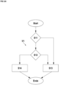
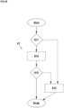
- the Figures 1A and 1B each explain an embodiment of a method V1 for locating a vehicle with high accuracy.
- the position of the vehicle can be determined very precisely even if the external database of the vehicle's environment model provided by a server is faulty.
- the individual method steps are carried out in the vehicle with the help of a control computer, for example with the help of an ADAS control unit.
- a method step S11 it is checked whether an external database, which has been created by an external server and whose data represents a model of the vehicle's surroundings, is available in the vehicle for locating the vehicle. If it is determined that the external database is available in the vehicle, a subsequent method step S12 checks whether the external database can be used to locate the vehicle.
- the vehicle is then located either in a step S13 by using the position of the vehicle that was determined with the aid of a map of the vehicle's surroundings that was created in the vehicle while the vehicle was traveling, if it was previously determined in method step S13 that the external database cannot be used to locate the vehicle.
- the vehicle can be located in a method step S14 by using a position of the vehicle that was determined with the aid of the external database, if it was previously determined in method step S12 that the external database can be used to locate the vehicle.
- the external database provided by the server cannot be used for position determination in particular if a data set in the database is incomplete or of poor quality. Furthermore, the database provided by the server cannot be used if the current scene in which the vehicle is located does not match the environment model of the database provided by the server. In addition, the external database provided by the server cannot be used if the current The vehicle's surroundings have few structures or textures.
- a (dynamic) map of the vehicle's surroundings is created by a control computer in the vehicle in method step S13 while the vehicle is traveling. The position of the vehicle is then determined using this map created in the vehicle. At the same time, the (dynamic) map is updated during the journey. The creation of the (dynamic) map and the localization of the vehicle thus take place almost in parallel during the same journey.
- method step S11 If it has been determined in method step S11 that an external database created by an external server and transmitted to the vehicle is available in the vehicle, but it is determined in method step S12 that the external database cannot be used to locate the vehicle, a (dynamic) map of the surroundings of the vehicle is also created in method step S13 while the vehicle is traveling and the position of the vehicle is determined using this map.
- method step S11 If, however, it is determined in method step S11 that an external database containing an environmental model of the vehicle is present in the vehicle and it is determined in method step S12 that this external database can actually be used to localize the vehicle, the position of the vehicle is determined in method step S14 using the external database.
- a camera in the vehicle first takes a picture of the vehicle's surroundings.
- the image data in the image are evaluated in the vehicle using the vehicle's control computer and compared with the data in the external database.
- feature points and/or objects are detected and extracted in the recorded image.
- the feature points and/or objects extracted in the recorded image are compared with feature points and/or objects determined from the external database in order to find feature points and/or objects that correspond to one another.
- the feature points and/or objects that correspond to each other are found using a matching process. Feature points and/or objects that do not correspond to each other or outliers are excluded from the process for localizing the vehicle.
- a chi-square test can be used for this purpose, for example.
- successive images of the surrounding scenery are recorded by a vehicle camera, for example a mono camera, while the vehicle is driving.
- the image data contained in the images are then evaluated in the vehicle using the vehicle's control computer.
- feature points and/or objects are extracted from the recorded images and compared with one another in order to find feature points and/or objects that correspond to one another in the various images.
- the feature points can be, for example, edges or corners of an object present in the vehicle's surroundings or protruding image areas.
- the corresponding feature points and/or objects are thus also determined in method step S13 by a matching process between the images taken at different times during the journey.
- the vehicle's control computer creates the (dynamic) map in the vehicle by determining a three-dimensional position in the vehicle's surroundings for each of the corresponding feature points and/or for each of the corresponding objects.
- the position of the vehicle can be determined with high precision both in method step S13 and in method step S14.
- the in Figure 1B The second embodiment of the method shown differs from that shown in Figure 1A
- the first embodiment of the method shown in the drawing is characterized in that the method step S14 is already carried out after the method step S11.
- the method step S11 it is first checked whether an external database, which has been created by an external server and whose data represents a model of an environment of the vehicle, is available in the vehicle for Localization of the vehicle is available. If it is determined that there is no external database in the vehicle, the vehicle is localized according to method step S13. In this case, the position of the vehicle is determined using the (dynamic) map that was created in the vehicle during the journey.
- the position of the vehicle is first determined using the external database in method step S14. Using the determined position, it is then checked in method step S12 whether the external database can be used to locate the vehicle. If the check in method step S12 has determined that the external database can be used to locate the vehicle, the vehicle is located using the position of the vehicle that was previously determined in method step S14 using the external database.
- the position of the vehicle is determined in particular by creating the map in the vehicle if it is determined in method step S12 that the position previously determined in method step S14 with the aid of the external database has insufficient accuracy.
- the vehicle is located in method step S13 by using the position of the vehicle that was determined using the (dynamic) map of the vehicle's surroundings that was created in the vehicle while the vehicle was traveling.
- Determining the position of the vehicle using process steps S13 or S14 corresponds to the process sequence as described in the Figure 1A for the process steps S13 and S14.
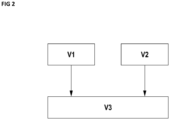
- both the method step S13 and the method step S14 have a relatively high computing time. If it is assumed that the vehicle continues to move during the evaluation and calculations of the individual method steps of the method sequence V1, has moved, it is not possible to determine exactly where the vehicle is currently located. It is only possible to determine where the vehicle was a certain time ago, i.e. at the beginning of the calculation time for the procedure V1.
- a movement or a state of movement of the vehicle is determined by evaluating sensor data provided by vehicle sensors in the vehicle. For this purpose, data from vehicle sensors, for example from steering wheel sensors, wheel sensors or an inertial measuring unit, are evaluated. Starting from a known fixed point, which is connected to the Figure 1 Once the position has been determined using the specified procedure V1, a further, current position of the vehicle can be determined or estimated using dead reckoning depending on the detected movement of the vehicle. Using the movement of the vehicle, a further, current position of the vehicle, including altitude information, can thus be approximately determined or estimated.
- an error in the position estimated using dead reckoning can be determined.
- the further position approximately determined using procedure V2 can be corrected using the position of the vehicle, which was determined using the external database or using the map created in the vehicle in procedure V1. Kalman filtering can be used for correction.
Landscapes
- Engineering & Computer Science (AREA)
- Radar, Positioning & Navigation (AREA)
- Remote Sensing (AREA)
- Automation & Control Theory (AREA)
- Physics & Mathematics (AREA)
- General Physics & Mathematics (AREA)
- Navigation (AREA)
- Traffic Control Systems (AREA)
Claims (13)
- Procédé de localisation d'un véhicule, comprenant :- le fait d'opérer une vérification (S11) pour savoir si une base de données externe, qui a été créée par un serveur externe et dont les données représentent un modèle d'un environnement du véhicule, est disponible dans le véhicule pour la localisation du véhicule,- le fait d'opérer une vérification (S12) pour savoir si la base de données externe est utilisable pour la localisation du véhicule lorsqu'il a été constaté au préalable que la base de données externe est disponible dans le véhicule,- le fait de prendre une image de l'environnement du véhicule par une caméra située dans le véhicule,- le fait de localiser (S14) le véhicule en utilisant une position du véhicule, qui a été déterminée à l'aide de l'image enregistrée et de la base de données externe lorsqu'il a été constaté au préalable que la base de données externe peut être utilisée pour la localisation du véhicule, et le fait de localiser (S13) le véhicule en utilisant la position du véhicule, qui a été déterminée à l'aide de l'image enregistrée et d'une carte d'un environnement du véhicule, qui a été créée dans le véhicule pendant le trajet du véhicule, lorsqu'il a été constaté au préalable que la base de données externe ne peut pas être utilisée pour la localisation du véhicule.
- Procédé selon la revendication 1, dans lequel la position du véhicule est déterminée en créant la carte dans le véhicule lorsqu'il est constaté que la position déterminée à l'aide de la base de données externe présente une précision insuffisante.
- Procédé selon l'une quelconque des revendications 1 ou 2, dans lequel la base de données externe fournie par le serveur ne peut pas alors être utilisée pour définir la position lorsqu'un ensemble de données de la base de données n'est pas complet.
- Procédé selon l'une quelconque des revendications 1 à 3, dans lequel la position du véhicule est déterminée en créant la carte dans le véhicule lorsqu'il a été constaté que l'environnement du véhicule ne concorde pas avec le modèle de l'environnement, qui est représenté par les données de la base de données externe.
- Procédé selon l'une quelconque des revendications 1 à 4, dans lequel la position du véhicule est déterminée en créant la carte dans le véhicule lorsqu'il a été constaté que l'environnement du véhicule ne présente aucune texture ou un nombre inférieur à un nombre prédéfini de textures.
- Procédé selon l'une quelconque des revendications 1 à 5, dans lequel la position du véhicule est déterminée à l'aide de la base de données externe en ce que des données d'image présentes sur l'image sont évaluées et sont comparées aux données de la base de données externe.
- Procédé selon la revendication 6, dans lequel des points de caractéristique et/ou des objets sont extraits sur l'image enregistrée et sont mis en regard avec des points de caractéristique et/ou des objets qui sont déterminés à partir de la base de données externe pour trouver des points de caractéristique et/ou des objets correspondant les uns aux autres sur l'image enregistrée et dans la base de données externe.
- Procédé selon la revendication 7, dans lequel des points de caractéristique et/ou des objets ne correspondant pas les uns aux autres sont exclus du procédé de localisation du véhicule.
- Procédé selon l'une quelconque des revendications 1 à 8, dans lequel la carte est créée dans le véhicule en ce que pendant le trajet du véhicule, des images successives sont enregistrées par une caméra du véhicule et des données d'image présentes sur les images sont évaluées.
- Procédé selon la revendication 9, dans lequel des points de caractéristique et/ou des objets sont extraits dans les images enregistrées et sont mis en regard entre eux pour trouver des points de caractéristique et/ou des objets correspondant les uns aux autres sur les images enregistrées.
- Procédé selon la revendication 10, dans lequel la carte est créée dans le véhicule en ce qu'une position tridimensionnelle dans l'environnement du véhicule est déterminée pour chacun des points de caractéristique correspondant les uns aux autres et/ou pour chacun des objets correspondant les uns aux autres.
- Procédé selon l'une quelconque des revendications 1 à 11, comprenant :- la détermination d'un déplacement du véhicule en évaluant des données de capteur, qui sont fournies par des capteurs de véhicule du véhicule dans le véhicule,- la détermination d'une autre position du véhicule en fonction du déplacement déterminé du véhicule.
- Procédé selon la revendication 12, comprenant en outre :- la correction de l'autre position déterminée du véhicule en utilisant la position du véhicule qui a été déterminée à l'aide de la base de données externe ou de la carte créée dans le véhicule.
Applications Claiming Priority (2)
| Application Number | Priority Date | Filing Date | Title |
|---|---|---|---|
| DE102019209117.2A DE102019209117A1 (de) | 2019-06-25 | 2019-06-25 | Verfahren zur Lokalisierung eines Fahrzeugs |
| PCT/EP2020/067002 WO2020260134A1 (fr) | 2019-06-25 | 2020-06-18 | Procédé de localisation d'un véhicule |
Publications (3)
| Publication Number | Publication Date |
|---|---|
| EP4004491A1 EP4004491A1 (fr) | 2022-06-01 |
| EP4004491B1 true EP4004491B1 (fr) | 2025-01-08 |
| EP4004491C0 EP4004491C0 (fr) | 2025-01-08 |
Family
ID=71108641
Family Applications (1)
| Application Number | Title | Priority Date | Filing Date |
|---|---|---|---|
| EP20733798.1A Active EP4004491B1 (fr) | 2019-06-25 | 2020-06-18 | Procédé de localisation d'un véhicule |
Country Status (3)
| Country | Link |
|---|---|
| EP (1) | EP4004491B1 (fr) |
| DE (1) | DE102019209117A1 (fr) |
| WO (1) | WO2020260134A1 (fr) |
Families Citing this family (1)
| Publication number | Priority date | Publication date | Assignee | Title |
|---|---|---|---|---|
| DE102021208832A1 (de) | 2021-08-12 | 2023-02-16 | Robert Bosch Gesellschaft mit beschränkter Haftung | Vervollständigen von merkmalsbasierten Lokalisierungskarten |
Citations (1)
| Publication number | Priority date | Publication date | Assignee | Title |
|---|---|---|---|---|
| WO2018191818A1 (fr) * | 2017-04-18 | 2018-10-25 | Clearpath Robotics Inc. | Véhicule de transport de matériau autonome sans conducteur |
Family Cites Families (9)
| Publication number | Priority date | Publication date | Assignee | Title |
|---|---|---|---|---|
| US5359529A (en) * | 1992-05-15 | 1994-10-25 | Zexel Corporation | Route guidance on/off-route state filter |
| DE102008053531A1 (de) * | 2007-11-02 | 2009-05-14 | Continental Engineering Services Gmbh | Verifikation von digitalen Karten |
| US20130131985A1 (en) * | 2011-04-11 | 2013-05-23 | James D. Weiland | Wearable electronic image acquisition and enhancement system and method for image acquisition and visual enhancement |
| KR20160002178A (ko) * | 2014-06-30 | 2016-01-07 | 현대자동차주식회사 | 자차 위치 인식 장치 및 방법 |
| DE102014015073B4 (de) * | 2014-10-11 | 2021-02-25 | Audi Ag | Verfahren zur Aktualisierung und/oder Erweiterung eines Kartendatensatzes einer begrenzten Umgebung |
| DE102015217371A1 (de) * | 2015-09-11 | 2017-03-16 | Continental Automotive Gmbh | Verfahren zum automatisierten Fahren mit Nutzung von Kartendaten |
| DE102017211613A1 (de) * | 2017-07-07 | 2019-01-10 | Robert Bosch Gmbh | Verfahren zur Verifizierung einer digitalen Karte eines höher automatisierten Fahrzeugs (HAF), insbesondere eines hochautomatisierten Fahrzeugs |
| US10474149B2 (en) * | 2017-08-18 | 2019-11-12 | GM Global Technology Operations LLC | Autonomous behavior control using policy triggering and execution |
| KR102323394B1 (ko) * | 2018-01-22 | 2021-11-08 | 삼성전자주식회사 | 차량의 주행을 보조하는 장치 및 방법 |
-
2019
- 2019-06-25 DE DE102019209117.2A patent/DE102019209117A1/de active Pending
-
2020
- 2020-06-18 EP EP20733798.1A patent/EP4004491B1/fr active Active
- 2020-06-18 WO PCT/EP2020/067002 patent/WO2020260134A1/fr not_active Ceased
Patent Citations (1)
| Publication number | Priority date | Publication date | Assignee | Title |
|---|---|---|---|---|
| WO2018191818A1 (fr) * | 2017-04-18 | 2018-10-25 | Clearpath Robotics Inc. | Véhicule de transport de matériau autonome sans conducteur |
Also Published As
| Publication number | Publication date |
|---|---|
| WO2020260134A1 (fr) | 2020-12-30 |
| EP4004491C0 (fr) | 2025-01-08 |
| DE102019209117A1 (de) | 2020-12-31 |
| EP4004491A1 (fr) | 2022-06-01 |
Similar Documents
| Publication | Publication Date | Title |
|---|---|---|
| DE102015214338A1 (de) | Bestimmung einer Anordnungsinformation für ein Fahrzeug | |
| EP3440431A1 (fr) | Procédé de détermination d'une pose d'un véhicule fonctionnant au moins de façon partiellement automatique dans un environnement au moyen de repères | |
| DE102017210070A1 (de) | Verfahren zum Erstellen einer digitalen Karte für ein automatisiertes Fahrzeug | |
| DE102019207870A1 (de) | Verfahren zur Erstellung einer Umgebungskarte für die Verwendung bei der autonomen Navigation eines mobilen Roboters | |
| DE102021214441A1 (de) | Verfahren zur Korrektur einer Orientierungswinkel-Ermittlung eines Sensorsystems einer Arbeitsmaschine | |
| DE102018222169A1 (de) | Bordeigenes visuelles Ermitteln kinematischer Messgrößen eines Schienenfahrzeugs | |
| DE102014207694B4 (de) | Verfahren zum Evaluieren der Errechnung von Umfeldmodellen durch Fahrzeuge | |
| EP2381207A1 (fr) | Mesure de cible 3D et orientation de cible à partir de données IR | |
| DE102018132921A1 (de) | Verfahren zum Betreiben eines Feldgeräts der Automatisierungstechnik in einer Augmented-Reality/Mixed-Reality- Umgebung | |
| DE102010042821B4 (de) | Verfahren und Vorrichtung zur Bestimmung einer Basisbreite eines Stereo-Erfassungssystems | |
| DE102016223526A1 (de) | Verfahren und Vorrichtung zum Bestimmen einer ersten hochgenauen Position eines Fahrzeugs | |
| EP4148386B1 (fr) | Détermination d'une position initiale absolue d'un véhicule | |
| WO2016000919A1 (fr) | Procédé de détermination, dans un système principal, et de fourniture à un véhicule, d'un ensemble de données décrivant un point de repère pour la détermination de position propre par le véhicule | |
| WO2020260134A1 (fr) | Procédé de localisation d'un véhicule | |
| WO2018172240A1 (fr) | Procédé et dispositif d'évaluation permettant de détecter un environnement d'un véhicule et véhicule | |
| DE102020006160A1 (de) | Verfahren zur Lageerkennung eines Objekts mittels eines Lageerfassungssystems, Verfahren zum Bearbeiten eines Objekts sowie Lageerfassungssystem | |
| WO2020104263A1 (fr) | Procédé, appareil de commande, système et programme informatique permettant de déterminer des points d'objet caractéristiques d'un objet cible, ainsi que procédé de positionnement d'un véhicule à moteur de manière assistée par caméra | |
| DE102016222664A1 (de) | Verfahren zur Installation eines Lokalisierungssystems | |
| DE102012214579A1 (de) | Containeranlage und deren Betrieb | |
| DE102017217063A1 (de) | Erkennungssystem, Arbeitsverfahren und Trainingsverfahren zum Erzeugen eines 3D-Modells mit Referenzdaten | |
| DE102007021107B4 (de) | Vorrichtung und Verfahren zum Bestimmen des Hauptpunktes eines Kamerasystems | |
| DE102017007764A1 (de) | Verfahren und Vorrichtung zum Generieren einer sensorspezifischen Sensormerkmalkarte einer Umgebung eines Fahrzeugs | |
| DE102006051539A1 (de) | Verfahren und Vorrichtung zur luftbildgestützten Umgebungserfassung bei Kraftfahrzeugen | |
| DE102020213111A1 (de) | Verfahren und System zur Bestimmung einer Pose oder Position eines mobilen Endgeräts | |
| DE102018217194A1 (de) | Verfahren zum Lokalisieren eines Fahrzeugs |
Legal Events
| Date | Code | Title | Description |
|---|---|---|---|
| STAA | Information on the status of an ep patent application or granted ep patent |
Free format text: STATUS: UNKNOWN |
|
| STAA | Information on the status of an ep patent application or granted ep patent |
Free format text: STATUS: THE INTERNATIONAL PUBLICATION HAS BEEN MADE |
|
| PUAI | Public reference made under article 153(3) epc to a published international application that has entered the european phase |
Free format text: ORIGINAL CODE: 0009012 |
|
| STAA | Information on the status of an ep patent application or granted ep patent |
Free format text: STATUS: REQUEST FOR EXAMINATION WAS MADE |
|
| 17P | Request for examination filed |
Effective date: 20220421 |
|
| AK | Designated contracting states |
Kind code of ref document: A1 Designated state(s): AL AT BE BG CH CY CZ DE DK EE ES FI FR GB GR HR HU IE IS IT LI LT LU LV MC MK MT NL NO PL PT RO RS SE SI SK SM TR |
|
| DAV | Request for validation of the european patent (deleted) | ||
| DAX | Request for extension of the european patent (deleted) | ||
| RIC1 | Information provided on ipc code assigned before grant |
Ipc: G01C 21/00 20060101ALI20230914BHEP Ipc: G01C 21/30 20060101AFI20230914BHEP |
|
| STAA | Information on the status of an ep patent application or granted ep patent |
Free format text: STATUS: EXAMINATION IS IN PROGRESS |
|
| 17Q | First examination report despatched |
Effective date: 20231025 |
|
| 111L | Licence recorded |
Designated state(s): AL AT BE BG CH CY CZ DE DK EE ES FI FR GB GR HR HU IE IS IT LT LU LV MC MK MT NL NO PL PT RO RS SE SI SK SM TR Free format text: EXCLUSIVE LICENSE Name of requester: QUALCOMM TECHNOLOGIES, INC., US Effective date: 20231103 |
|
| GRAP | Despatch of communication of intention to grant a patent |
Free format text: ORIGINAL CODE: EPIDOSNIGR1 |
|
| STAA | Information on the status of an ep patent application or granted ep patent |
Free format text: STATUS: GRANT OF PATENT IS INTENDED |
|
| INTG | Intention to grant announced |
Effective date: 20240801 |
|
| GRAS | Grant fee paid |
Free format text: ORIGINAL CODE: EPIDOSNIGR3 |
|
| GRAA | (expected) grant |
Free format text: ORIGINAL CODE: 0009210 |
|
| STAA | Information on the status of an ep patent application or granted ep patent |
Free format text: STATUS: THE PATENT HAS BEEN GRANTED |
|
| 111L | Licence recorded |
Designated state(s): AL AT BE BG CH CY CZ DE DK EE ES FI FR GB GR HR HU IE IS IT LT LU LV MC MK MT NL NO PL PT RO RS SE SI SK SM TR Free format text: EXCLUSIVE LICENSE Name of requester: QUALCOMM TECHNOLOGIES, INC., US Effective date: 20231103 |
|
| AK | Designated contracting states |
Kind code of ref document: B1 Designated state(s): AL AT BE BG CH CY CZ DE DK EE ES FI FR GB GR HR HU IE IS IT LI LT LU LV MC MK MT NL NO PL PT RO RS SE SI SK SM TR |
|
| REG | Reference to a national code |
Ref country code: GB Ref legal event code: FG4D Free format text: NOT ENGLISH |
|
| REG | Reference to a national code |
Ref country code: CH Ref legal event code: EP |
|
| REG | Reference to a national code |
Ref country code: DE Ref legal event code: R096 Ref document number: 502020010156 Country of ref document: DE |
|
| REG | Reference to a national code |
Ref country code: IE Ref legal event code: FG4D Free format text: LANGUAGE OF EP DOCUMENT: GERMAN |
|
| U01 | Request for unitary effect filed |
Effective date: 20250127 |
|
| U07 | Unitary effect registered |
Designated state(s): AT BE BG DE DK EE FI FR IT LT LU LV MT NL PT RO SE SI Effective date: 20250131 |
|
| RAP2 | Party data changed (patent owner data changed or rights of a patent transferred) |
Owner name: CONTINENTAL AUTOMOTIVE TECHNOLOGIES GMBH |
|
| U1K | Transfer of rights of the unitary patent after the registration of the unitary effect |
Owner name: CONTINENTAL AUTOMOTIVE TECHNOLOGIES GMBH; DE |
|
| U20 | Renewal fee for the european patent with unitary effect paid |
Year of fee payment: 6 Effective date: 20250512 |
|
| PG25 | Lapsed in a contracting state [announced via postgrant information from national office to epo] |
Ref country code: RS Free format text: LAPSE BECAUSE OF FAILURE TO SUBMIT A TRANSLATION OF THE DESCRIPTION OR TO PAY THE FEE WITHIN THE PRESCRIBED TIME-LIMIT Effective date: 20250408 |
|
| PG25 | Lapsed in a contracting state [announced via postgrant information from national office to epo] |
Ref country code: PL Free format text: LAPSE BECAUSE OF FAILURE TO SUBMIT A TRANSLATION OF THE DESCRIPTION OR TO PAY THE FEE WITHIN THE PRESCRIBED TIME-LIMIT Effective date: 20250108 |
|
| PG25 | Lapsed in a contracting state [announced via postgrant information from national office to epo] |
Ref country code: ES Free format text: LAPSE BECAUSE OF FAILURE TO SUBMIT A TRANSLATION OF THE DESCRIPTION OR TO PAY THE FEE WITHIN THE PRESCRIBED TIME-LIMIT Effective date: 20250108 |
|
| PGFP | Annual fee paid to national office [announced via postgrant information from national office to epo] |
Ref country code: GB Payment date: 20250508 Year of fee payment: 6 |
|
| PG25 | Lapsed in a contracting state [announced via postgrant information from national office to epo] |
Ref country code: NO Free format text: LAPSE BECAUSE OF FAILURE TO SUBMIT A TRANSLATION OF THE DESCRIPTION OR TO PAY THE FEE WITHIN THE PRESCRIBED TIME-LIMIT Effective date: 20250408 Ref country code: IS Free format text: LAPSE BECAUSE OF FAILURE TO SUBMIT A TRANSLATION OF THE DESCRIPTION OR TO PAY THE FEE WITHIN THE PRESCRIBED TIME-LIMIT Effective date: 20250508 |
|
| PG25 | Lapsed in a contracting state [announced via postgrant information from national office to epo] |
Ref country code: HR Free format text: LAPSE BECAUSE OF FAILURE TO SUBMIT A TRANSLATION OF THE DESCRIPTION OR TO PAY THE FEE WITHIN THE PRESCRIBED TIME-LIMIT Effective date: 20250108 |
|
| PG25 | Lapsed in a contracting state [announced via postgrant information from national office to epo] |
Ref country code: GR Free format text: LAPSE BECAUSE OF FAILURE TO SUBMIT A TRANSLATION OF THE DESCRIPTION OR TO PAY THE FEE WITHIN THE PRESCRIBED TIME-LIMIT Effective date: 20250409 |
|
| PGFP | Annual fee paid to national office [announced via postgrant information from national office to epo] |
Ref country code: IE Payment date: 20250514 Year of fee payment: 6 |
|
| PG25 | Lapsed in a contracting state [announced via postgrant information from national office to epo] |
Ref country code: SM Free format text: LAPSE BECAUSE OF FAILURE TO SUBMIT A TRANSLATION OF THE DESCRIPTION OR TO PAY THE FEE WITHIN THE PRESCRIBED TIME-LIMIT Effective date: 20250108 |
|
| PG25 | Lapsed in a contracting state [announced via postgrant information from national office to epo] |
Ref country code: CZ Free format text: LAPSE BECAUSE OF FAILURE TO SUBMIT A TRANSLATION OF THE DESCRIPTION OR TO PAY THE FEE WITHIN THE PRESCRIBED TIME-LIMIT Effective date: 20250108 |
|
| PG25 | Lapsed in a contracting state [announced via postgrant information from national office to epo] |
Ref country code: SK Free format text: LAPSE BECAUSE OF FAILURE TO SUBMIT A TRANSLATION OF THE DESCRIPTION OR TO PAY THE FEE WITHIN THE PRESCRIBED TIME-LIMIT Effective date: 20250108 |
|
| PLBE | No opposition filed within time limit |
Free format text: ORIGINAL CODE: 0009261 |
|
| STAA | Information on the status of an ep patent application or granted ep patent |
Free format text: STATUS: NO OPPOSITION FILED WITHIN TIME LIMIT |
|
| REG | Reference to a national code |
Ref country code: CH Ref legal event code: L10 Free format text: ST27 STATUS EVENT CODE: U-0-0-L10-L00 (AS PROVIDED BY THE NATIONAL OFFICE) Effective date: 20251119 |
|
| 26N | No opposition filed |
Effective date: 20251009 |
|
| REG | Reference to a national code |
Ref country code: GB Ref legal event code: 732E Free format text: REGISTERED BETWEEN 20251204 AND 20251210 |
|
| REG | Reference to a national code |
Ref country code: CH Ref legal event code: H13 Free format text: ST27 STATUS EVENT CODE: U-0-0-H10-H13 (AS PROVIDED BY THE NATIONAL OFFICE) Effective date: 20260127 |
|
| PG25 | Lapsed in a contracting state [announced via postgrant information from national office to epo] |
Ref country code: MC Free format text: LAPSE BECAUSE OF FAILURE TO SUBMIT A TRANSLATION OF THE DESCRIPTION OR TO PAY THE FEE WITHIN THE PRESCRIBED TIME-LIMIT Effective date: 20250108 |
|
| U1H | Name or address of the proprietor changed after the registration of the unitary effect |
Owner name: AUMOVIO GERMANY GMBH; DE |
|
| PG25 | Lapsed in a contracting state [announced via postgrant information from national office to epo] |
Ref country code: CH Free format text: LAPSE BECAUSE OF NON-PAYMENT OF DUE FEES Effective date: 20250630 |