EP0843285A2 - Verfahren zur Herstellung von Kartenrasterdaten - Google Patents
Verfahren zur Herstellung von Kartenrasterdaten Download PDFInfo
- Publication number
- EP0843285A2 EP0843285A2 EP97120292A EP97120292A EP0843285A2 EP 0843285 A2 EP0843285 A2 EP 0843285A2 EP 97120292 A EP97120292 A EP 97120292A EP 97120292 A EP97120292 A EP 97120292A EP 0843285 A2 EP0843285 A2 EP 0843285A2
- Authority
- EP
- European Patent Office
- Prior art keywords
- map
- data
- coordinates
- latitude
- longitude
- Prior art date
- Legal status (The legal status is an assumption and is not a legal conclusion. Google has not performed a legal analysis and makes no representation as to the accuracy of the status listed.)
- Withdrawn
Links
Images


Classifications
-
- G—PHYSICS
- G06—COMPUTING OR CALCULATING; COUNTING
- G06T—IMAGE DATA PROCESSING OR GENERATION, IN GENERAL
- G06T3/00—Geometric image transformations in the plane of the image
Definitions
- the present invention relates to a method of preparation of raster map data used in map display device or the like.
- a method of preparation of raster map data for determining the coordinates of longitude and latitude of electronic data map by indicating objects in existing map.
- the raster map data is the map data used in image housing map display device or taxi map display system.
- a conventional method of preparing raster map data is realized by input of coordinates of latitude and longitude of four corners of a paper map.
- the method of preparation of raster map data of the invention is characterized by preparing an image file from a paper map, displaying existing map data and this prepared image file simultaneously, designating two or more corresponding objects, providing the image file with coordinates, and preparing raster map data.
- raster map data can be prepared from an arbitrary map by a simple operation by, for example, clicking the corresponding objects on the simultaneously displayed existing map data and image file by a mouse.
- the map to be used may be a map with unknown coordinates of four corners, a map of unknown system of coordinates or drafting method, or aerial photograph or topographic map.
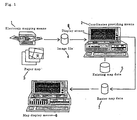
- Fig. 1 is a system diagram showing an embodiment of method of preparation of raster map data according the invention.
- Fig. 2 is a diagram showing an example of operation and display of coordinates providing means in a first embodiment and a second embodiment of the invention.
- Fig. 3 is a diagram showing an example of operation and display of coordinates providing means in a third embodiment of the invention.
- Fig. 4 is a diagram showing an example of display of existing map data and simplified image file for explaining the correction method of distortion of a parallelogram in a fourth embodiment of the invention.
- Fig. 5 is a diagram showing an example of display of existing map data and simplified image file for explaining the correction method of distortion of a trapezoid in a fifth embodiment of the invention.
- Fig. 6 is a diagram showing an example of display of existing map data and simplified image file for explaining the correction method of distortion of a graphic pattern in a sixth embodiment of the invention.
- Fig. 1 is a system diagram showing an embodiment of method of preparation of raster map data according the invention. First, referring to Fig. 1, a first embodiment is described below.
- Fig. 1 by electronic mapping means 1, for example, a scanner, an image file 4 of electronic data map is prepared from a paper map 3.
- Coordinate providing means 2 displays both the image file 4 and existing map data 5 simultaneously on a display screen 8 as shown in Fig. 2. The operator clicks the corresponding two objects on the two displayed map data by using a mouse to relate with each other.
- the dot coordinates of the lower left corner of the electronic data map is supposed to be (0 [dot], 0 [dot]).
- raster map data can be prepared from an ordinary paper map.
- Fig. 1 coordinates providing means 2 and map display means 6 are depicted as different terminals, but it is also possible to perform the operation of two means by using a same terminal. Moreover, if the paper map is available in an electronic format such as image file, the electronic mapping means 1 is not needed. In Fig. 2, two maps are displayed side by side, but they may be overlapped in display.
- an existing map may be pointed by a digitizer or the like, and the longitude and latitude may be taken in.
- a pointing device such as light pen and cross hair cursor may be used.
- the coordinates on the screen may be also entered from the keyboard.
- the image file map is free from distortion or rotation.
- the number of dots mx per unit latitude or the number of dots my per unit longitude is not determined, and therefore when selecting two points, it is important to select points not located on the same horizontal line or vertical line.
- the error is large, and the two points are preferred to be apart from each other as far as possible.
- the electronic data map of the image file 4 and existing map data 5 are simultaneously displayed in the coordinates providing means 2 as shown in Fig. 2.
- the latitude and longitude of the two points a, b on the electronic data map are known.
- the distance per second of latitude is always constant, and the distance per second of longitude can be calculated when the latitude is known, and therefore if the absolute values of latitude and longitude are known, the distance per unit latitude and the distance per unit longitude will be determined. Therefore, when two points a, b are designated, the aspect ratio of a rectangle having line segment ab as diagonal line is determined, and therefore if the aspect ratio of the rectangle of the electronic data map of the image file 4 does not coincide with the calculated value, it is known that the electronic data map is rotated. Accordingly, by rotating the electronic data map so as to match with the aspect ratio of the rectangle, an electronic data map in correct direction is obtained. In this way, by processing same as in the first embodiment after correcting the rotation of the electronic data map, the number of dots per second of latitude and the number of dots per second of longitude will be obtained.
- the electronic data map is only rotated without distortion, by designating two object points a and b, the rotation of the electronic data map can be corrected, and an electronic data map provided with latitude and longitude coordinates in correct direction can be prepared.
- FIG. 3 shows a display screen displaying the image file 4 and existing map data 5 simultaneously in this case.
- three objects are related on the image file and existing map data. That is, as compared with the case in which the objects at points a and b are processed by corresponding, dividing into a section of a and c and a section of c and b, the same processing as explained in the first embodiment is executed.
- the dot interpolating interval is shorter, thereby decreasing effects of errors due to difference in the system of coordinates, paper distortion, drafting error, or electronic mapping error.
- a fourth embodiment of the invention is described below.
- the fourth embodiment is intended to correct distortion and rotation of parallelogram of electronic data map and provide with latitude and longitude coordinates.
- Fig. 4 if three points c, a, b orthogonally crossing in the existing map data 5 are distorted to cross obliquely as in points c, a, b on the image file 4, the distortion can be corrected by transforming the coordinates so that the three points c, a, b on the image file 4 may cross orthogonally.
- This fifth embodiment is to correct the distortion of a rectangle into a trapezoid, instead of the parallelogram mentioned above.
- a distortion-free photograph is obtained when the camera is set in the perpendicular direction, but if the shooting direction is deviated from the perpendicular direction, a rectangular topography is distorted into a trapezoid. In such a case, the trapezoid can be corrected to the rectangle by designating four points as the objects.
- Fig. 5 shows a mode of correction of trapezoidal distortion by designating four objects in this embodiment of the invention.
- an image file 4 of electronic data map created from an aerial photograph and existing map data 5 of the corresponding region are simultaneously displayed on a display screen by the coordinates providing means 2 as shown in the embodiment in Fig. 1 same as in Fig. 2.
- the objects a, b, c, d of the existing map data 5 are designed to compose a rectangle, but it is not limited to a rectangle alone, and by designating proper four points and determining the latitude and longitude coordinates on the image file 4, the lattice supposed to be a rectangle is distorted into a trapezoid, which is a general case as experience often.
- a correct topographic map By detecting trapezoidal distortion of the latitude and longitude coordinates of the image file 4, when the coordinates are transformed to correct it, a correct topographic map will be obtained. For example, in the case of Fig. 5, by processing so as to expand in the lateral direction as going upward on the screen, the trapezoid can be corrected into a rectangle. After thus correcting into a rectangle of a same aspect ratio, by processing same as in the first embodiment, the latitude and longitude coordinates can be given to the electronic data map of the image file.
- a sixth embodiment of the invention is described below.
- a distorted topographic map can be provided with precise coordinates.
- Fig. 6 is a diagram for explaining the sixth embodiment of the invention, showing provision with latitude and longitude coordinates by designating five or more targets.
- the graphic pattern will be rectangular.
- the aspect ratio of this rectangle may be same as the aspect ratio of the existing map data
- a correct topographic map is obtained.
- a topographic map of correct azimuth is obtained.
- the paper map or aerial photograph is taken in by an image scanner or the like to plot electronic data map of image file, but it is evident that it can be used in application of coordinates of latitude and longitude to the map data of image file initially existing as electronic data, such as image data of aerial photograph taken by a digital camera.
- the invention can apply latitude and longitude coordinates to the electronic data map of image file created from an arbitrary paper map and prepare raster map data, only by relating two or more objects on the existing map data and the electronic data map of image file displayed simultaneously by the coordinates providing means.
- the invention can create raster map data.
- image data such as aerial photograph, satellite photograph, and sketch.
- the electronic data map is provided with latitude and longitude coordinates, but instead of the number of dots, of course, other scale may be also used.
Landscapes
- Physics & Mathematics (AREA)
- General Physics & Mathematics (AREA)
- Engineering & Computer Science (AREA)
- Theoretical Computer Science (AREA)
- Processing Or Creating Images (AREA)
- Instructional Devices (AREA)
Applications Claiming Priority (3)
| Application Number | Priority Date | Filing Date | Title |
|---|---|---|---|
| JP32214296 | 1996-11-19 | ||
| JP8322142A JPH10149092A (ja) | 1996-11-19 | 1996-11-19 | ラスタ地図データ作成方法 |
| JP322142/96 | 1996-11-19 |
Publications (2)
| Publication Number | Publication Date |
|---|---|
| EP0843285A2 true EP0843285A2 (de) | 1998-05-20 |
| EP0843285A3 EP0843285A3 (de) | 1999-10-06 |
Family
ID=18140403
Family Applications (1)
| Application Number | Title | Priority Date | Filing Date |
|---|---|---|---|
| EP97120292A Withdrawn EP0843285A3 (de) | 1996-11-19 | 1997-11-19 | Verfahren zur Herstellung von Kartenrasterdaten |
Country Status (2)
| Country | Link |
|---|---|
| EP (1) | EP0843285A3 (de) |
| JP (1) | JPH10149092A (de) |
Cited By (2)
| Publication number | Priority date | Publication date | Assignee | Title |
|---|---|---|---|---|
| CN112200714A (zh) * | 2020-09-27 | 2021-01-08 | 龙睿 | 一种基于精准矢量数图转换的投影的方法 |
| CN117252941A (zh) * | 2023-09-18 | 2023-12-19 | 青岛卓易策略数据信息技术有限公司 | 一种格栅地图绘制方法 |
Families Citing this family (1)
| Publication number | Priority date | Publication date | Assignee | Title |
|---|---|---|---|---|
| JP2007132851A (ja) * | 2005-11-11 | 2007-05-31 | Ps Trust:Kk | ナビゲーションプログラム及び装置 |
Family Cites Families (3)
| Publication number | Priority date | Publication date | Assignee | Title |
|---|---|---|---|---|
| US3748644A (en) * | 1969-12-31 | 1973-07-24 | Westinghouse Electric Corp | Automatic registration of points in two separate images |
| DE4028214C2 (de) * | 1990-09-06 | 1996-05-30 | Nuclear Cargo & Service Gmbh | Verfahren zur Umsetzung von in Werten eines geographischen Koordinatensystems erzeugten Standortdaten in eine auf einem karthesischen Koordinatensystem beruhende Rasterform |
| US5487139A (en) * | 1991-09-10 | 1996-01-23 | Niagara Mohawk Power Corporation | Method and system for generating a raster display having expandable graphic representations |
-
1996
- 1996-11-19 JP JP8322142A patent/JPH10149092A/ja active Pending
-
1997
- 1997-11-19 EP EP97120292A patent/EP0843285A3/de not_active Withdrawn
Cited By (3)
| Publication number | Priority date | Publication date | Assignee | Title |
|---|---|---|---|---|
| CN112200714A (zh) * | 2020-09-27 | 2021-01-08 | 龙睿 | 一种基于精准矢量数图转换的投影的方法 |
| CN117252941A (zh) * | 2023-09-18 | 2023-12-19 | 青岛卓易策略数据信息技术有限公司 | 一种格栅地图绘制方法 |
| CN117252941B (zh) * | 2023-09-18 | 2024-05-31 | 青岛卓易策略数据信息技术有限公司 | 一种格栅地图绘制方法 |
Also Published As
| Publication number | Publication date |
|---|---|
| JPH10149092A (ja) | 1998-06-02 |
| EP0843285A3 (de) | 1999-10-06 |
Similar Documents
| Publication | Publication Date | Title |
|---|---|---|
| US7792331B2 (en) | Composition of raster and vector graphics in geographic information systems | |
| JP2917155B2 (ja) | 画像結合装置及び方法 | |
| US4682160A (en) | Real time perspective display employing digital map generator | |
| EP0539144B1 (de) | Navigationssystem | |
| US4084184A (en) | Tv object locator and image identifier | |
| JPH07107548B2 (ja) | 人工衛星による測位方法 | |
| US7015967B1 (en) | Image formation system | |
| JP3225882B2 (ja) | 景観ラベリングシステム | |
| JP2010117291A (ja) | ナビゲーション装置 | |
| KR100373615B1 (ko) | 촬영 화상을 사용한 지도 작성 방법, 장치 및 촬영 화상의일그러짐 보정 방법 | |
| US20020009699A1 (en) | Data receiving device and image forming apparatus using same | |
| JP3931480B2 (ja) | 地図作成方法 | |
| EP0843285A2 (de) | Verfahren zur Herstellung von Kartenrasterdaten | |
| JP2002341757A (ja) | 地図作成システム及び記録媒体 | |
| JP3490774B2 (ja) | ジオスペシフィックテクスチャ生成の方法 | |
| JP2913814B2 (ja) | 地図データベース作成・修正システム | |
| JPH0555915B2 (de) | ||
| US20030117658A1 (en) | Method for processing map information | |
| US20150325045A1 (en) | Map drawing device | |
| JPS6236272B2 (de) | ||
| US20070003911A1 (en) | Method and system for cartographic projection of the terrestrial globe and map produced by this method | |
| JP3298972B2 (ja) | 図形処理方法 | |
| Dowman et al. | Photogrammetric applications of Landsat MSS imagery | |
| JP2000348160A (ja) | 地理情報システムの画像ファイル管理方法及び画像処理方法 | |
| JP4833787B2 (ja) | 境界特定装置、筆界特定装置、境界特定方法、筆界特定方法、及びプログラム |
Legal Events
| Date | Code | Title | Description |
|---|---|---|---|
| PUAI | Public reference made under article 153(3) epc to a published international application that has entered the european phase |
Free format text: ORIGINAL CODE: 0009012 |
|
| AK | Designated contracting states |
Kind code of ref document: A2 Designated state(s): DE FR GB NL |
|
| AX | Request for extension of the european patent |
Free format text: AL;LT;LV;MK;RO;SI |
|
| RIN1 | Information on inventor provided before grant (corrected) |
Inventor name: OHNISHI, HIROFUMI |
|
| PUAL | Search report despatched |
Free format text: ORIGINAL CODE: 0009013 |
|
| AK | Designated contracting states |
Kind code of ref document: A3 Designated state(s): AT BE CH DE DK ES FI FR GB GR IE IT LI LU MC NL PT SE |
|
| AX | Request for extension of the european patent |
Free format text: AL;LT;LV;MK;RO;SI |
|
| AKX | Designation fees paid |
Free format text: DE FR GB NL |
|
| STAA | Information on the status of an ep patent application or granted ep patent |
Free format text: STATUS: THE APPLICATION IS DEEMED TO BE WITHDRAWN |
|
| 18D | Application deemed to be withdrawn |
Effective date: 20000407 |